
 Submit Manuscript
 Peer Review
 Editor Work
2019 Vol. 8, No. 3
 Previous Issue
2019, 8(3): 281-302.
 Abstract
 1979KB
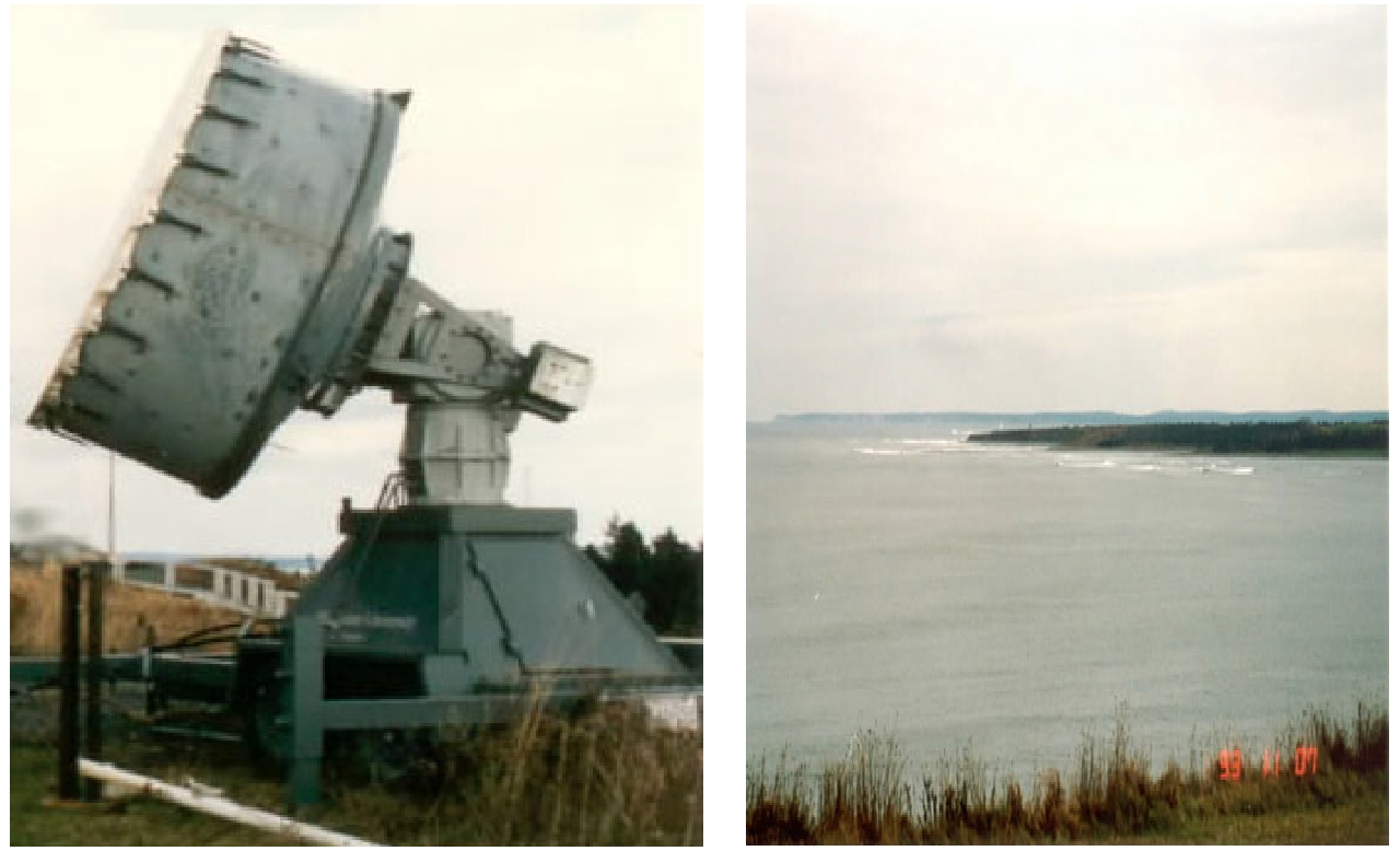
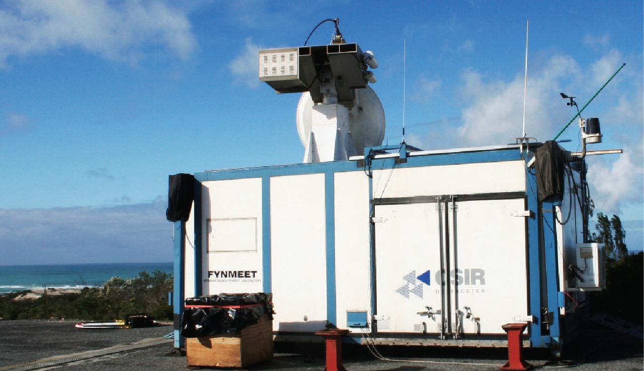
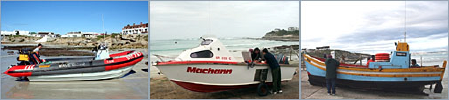
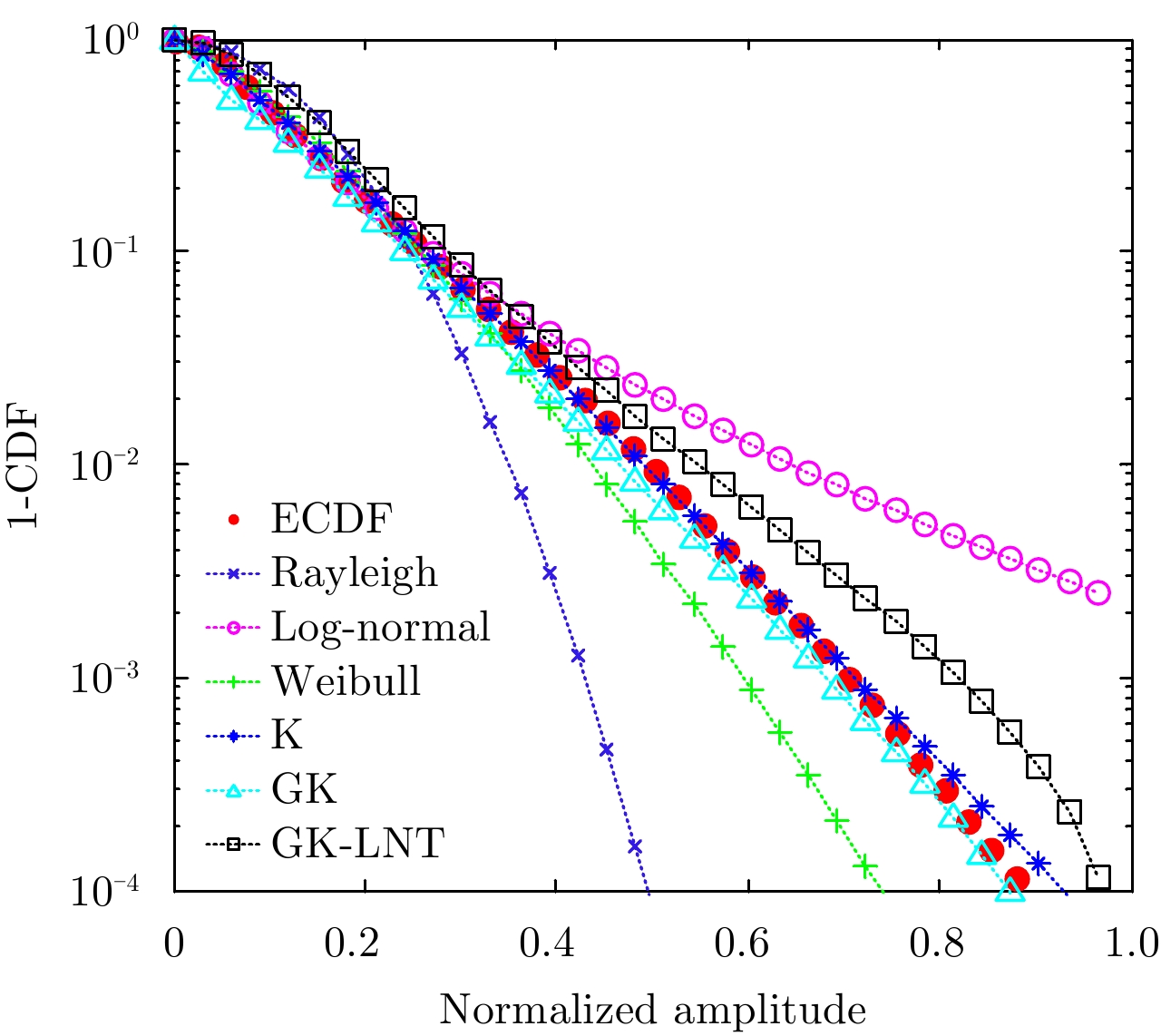
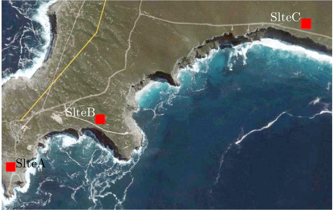
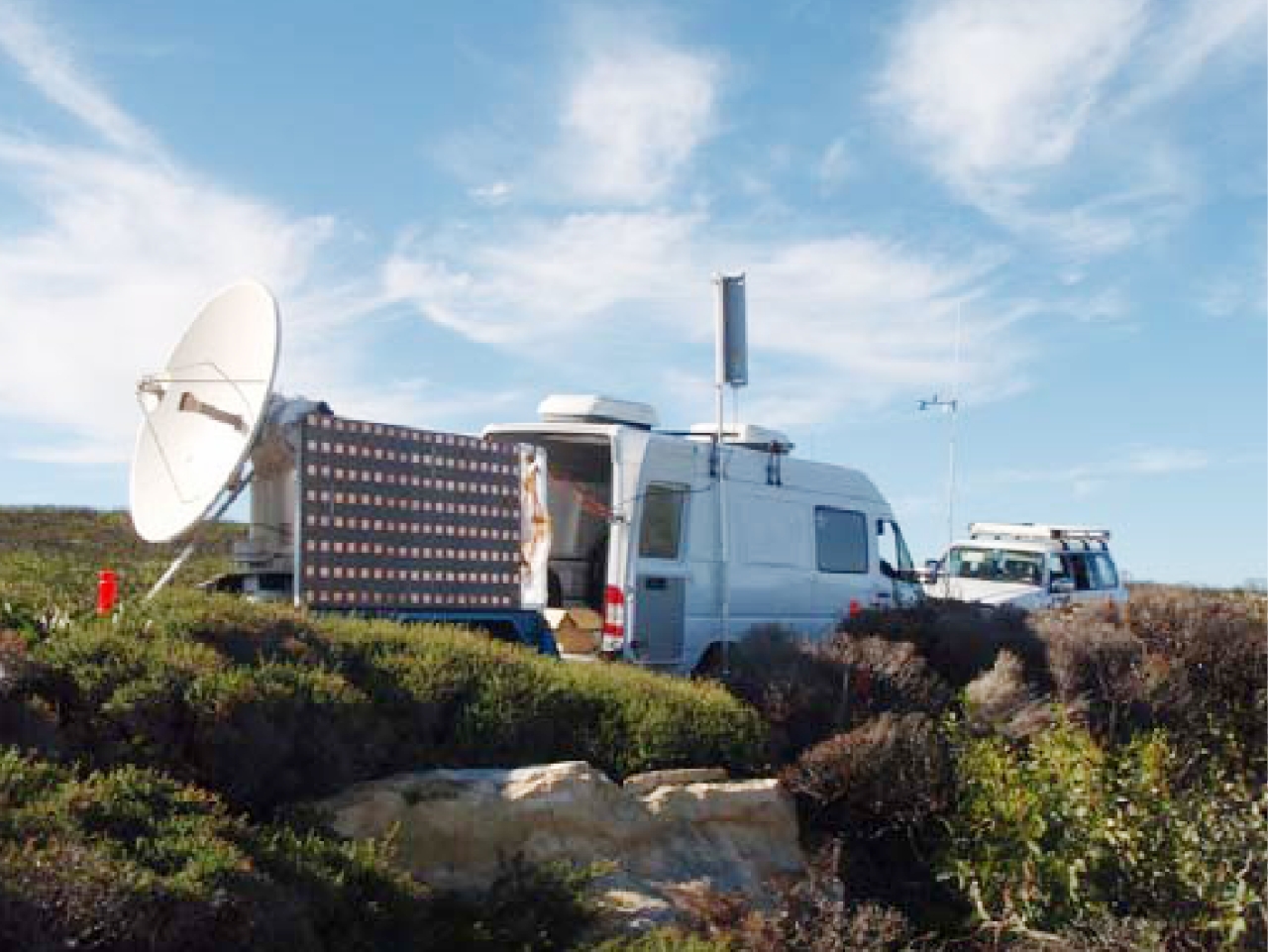
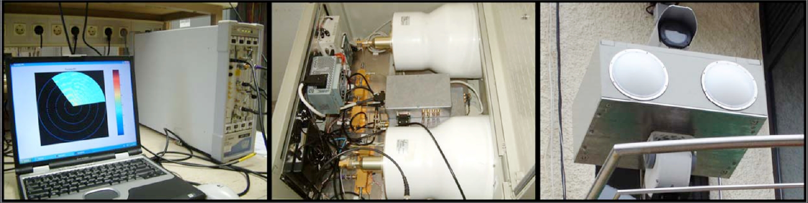
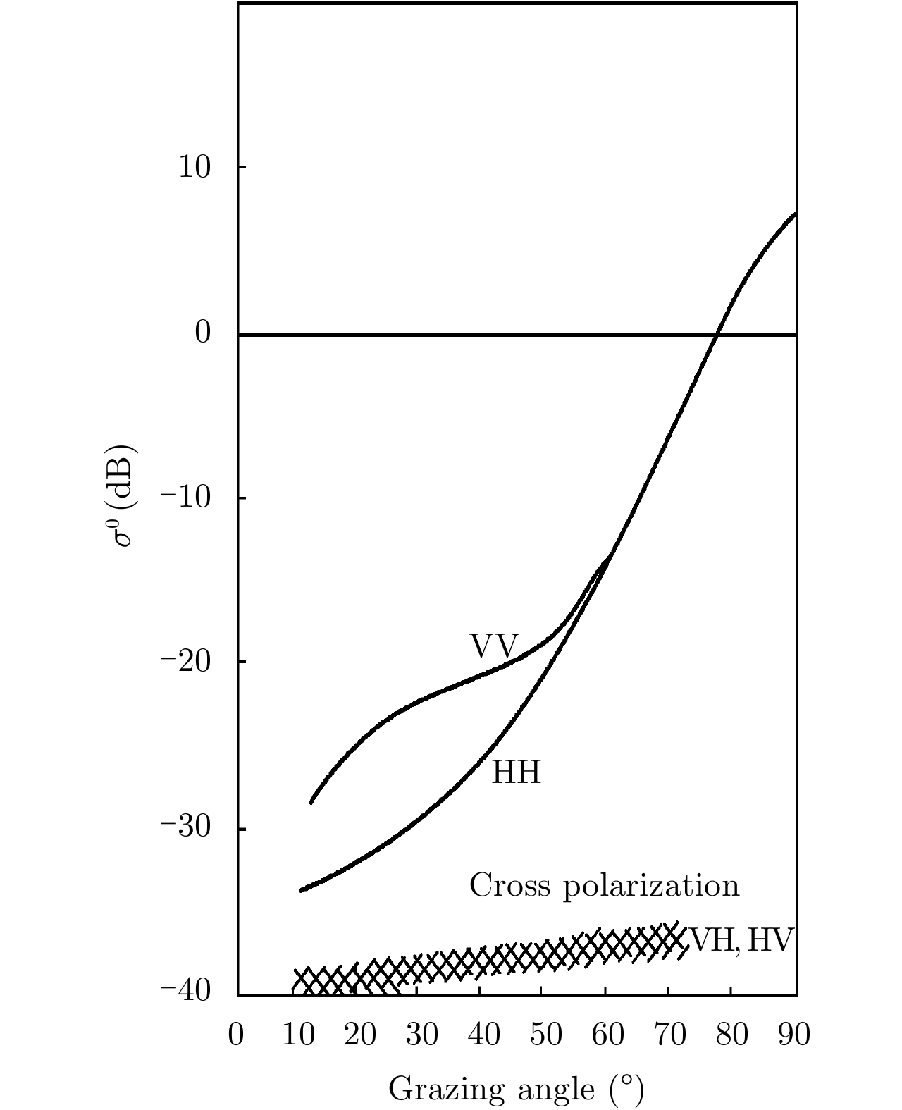
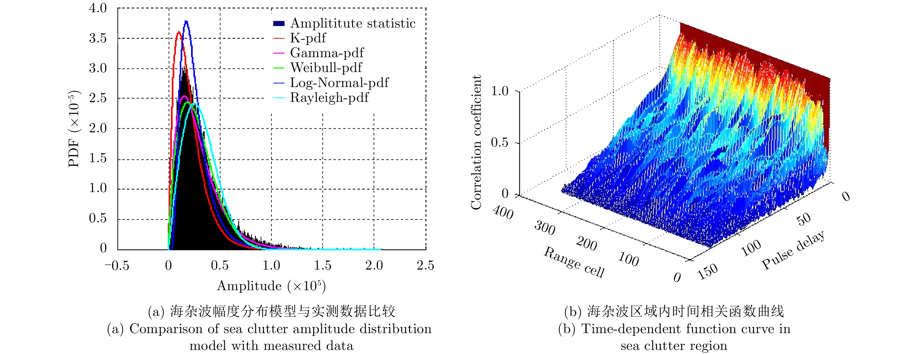
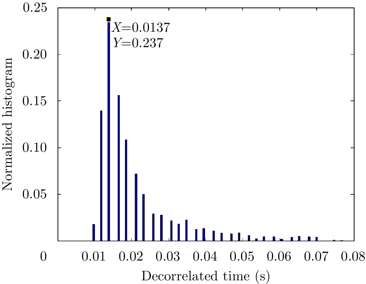
In complex marine environments, sea clutter greatly affects the detection performance of maritime targets. Because the influencing factors of sea clutter are numerous and the mechanism is complex, there are great difficulties in feature description and sea clutter suppression, and it is necessary to carry out long-term, systematic, continuous, and in-depth research. Carrying out sea clutter measurement experiments and obtaining measurement data under the influence of different parameters is an important prerequisite for supporting this research. This paper mainly focuses on the sea clutter measurements that have been carried out. First, typical experiments in various countries such as Canada, South Africa, Australia, the United States, Spain, and Germany are categorized and summarized from the aspects of shore-based experiment and airborne experiment. Then, sea clutter measurement experiments with wave tank conducted by the United States and Japan are reviewed, and domestic sea clutter measurement experiments as well as the construction of the maritime target detection experimental center in Yantai are briefly introduced. Finally, the future research directions that should be emphasized are projected: more systematic and continuous sea clutter measurement experiments need to be conducted; experiment and data analysis under explicit task background need to be strengthened; and sea clutter and target datasets that meet the requirement of intelligent radar applications need to be urgently constructed.
In complex marine environments, sea clutter greatly affects the detection performance of maritime targets. Because the influencing factors of sea clutter are numerous and the mechanism is complex, there are great difficulties in feature description and sea clutter suppression, and it is necessary to carry out long-term, systematic, continuous, and in-depth research. Carrying out sea clutter measurement experiments and obtaining measurement data under the influence of different parameters is an important prerequisite for supporting this research. This paper mainly focuses on the sea clutter measurements that have been carried out. First, typical experiments in various countries such as Canada, South Africa, Australia, the United States, Spain, and Germany are categorized and summarized from the aspects of shore-based experiment and airborne experiment. Then, sea clutter measurement experiments with wave tank conducted by the United States and Japan are reviewed, and domestic sea clutter measurement experiments as well as the construction of the maritime target detection experimental center in Yantai are briefly introduced. Finally, the future research directions that should be emphasized are projected: more systematic and continuous sea clutter measurement experiments need to be conducted; experiment and data analysis under explicit task background need to be strengthened; and sea clutter and target datasets that meet the requirement of intelligent radar applications need to be urgently constructed.


2019, 8(3): 303-317.
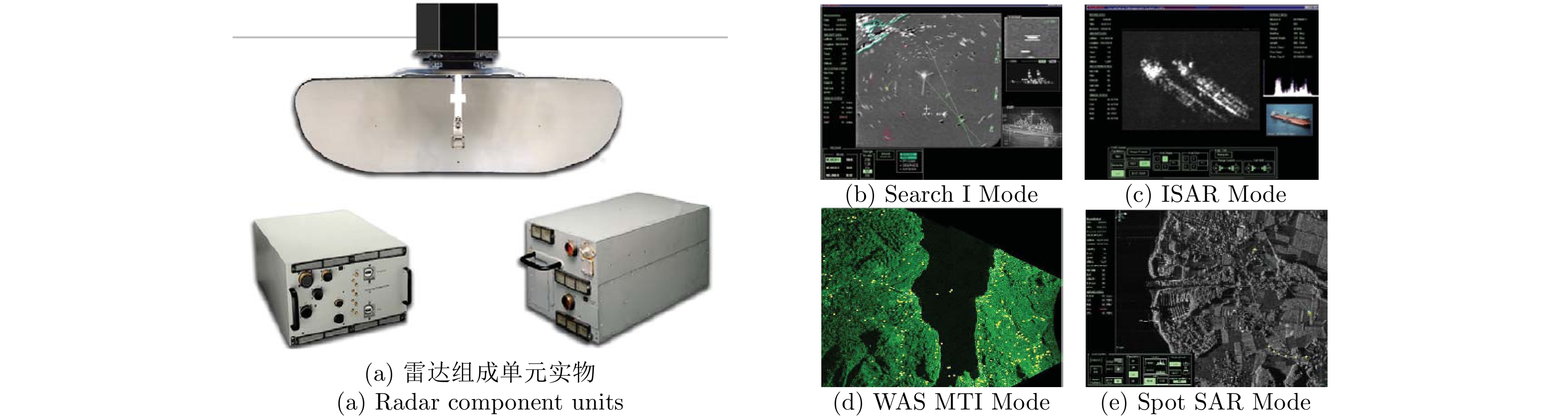
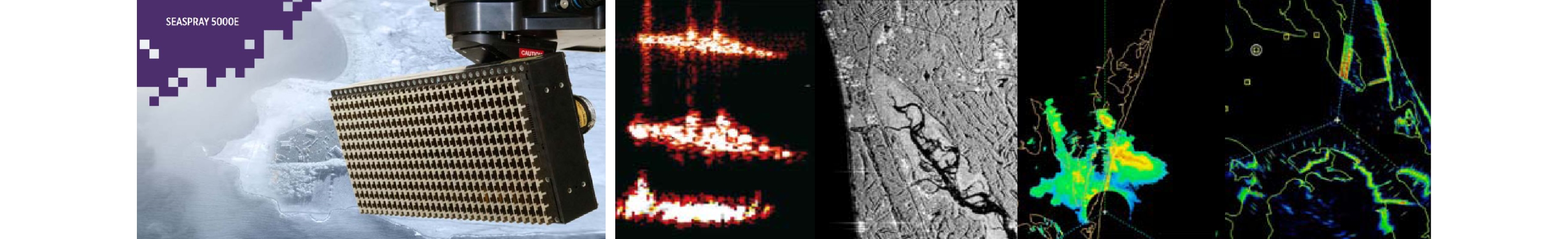
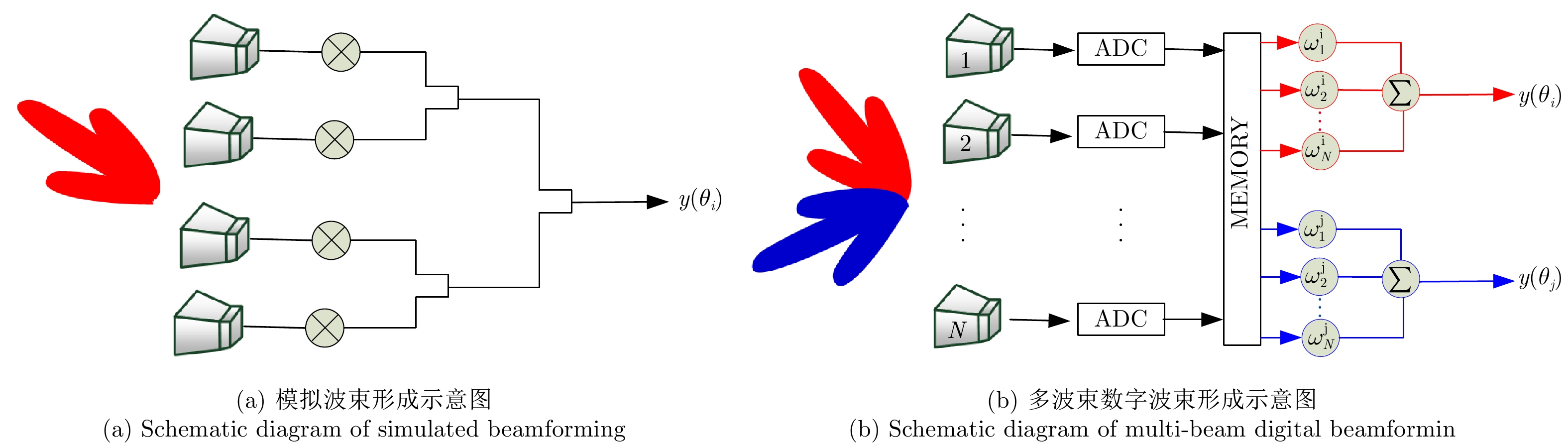
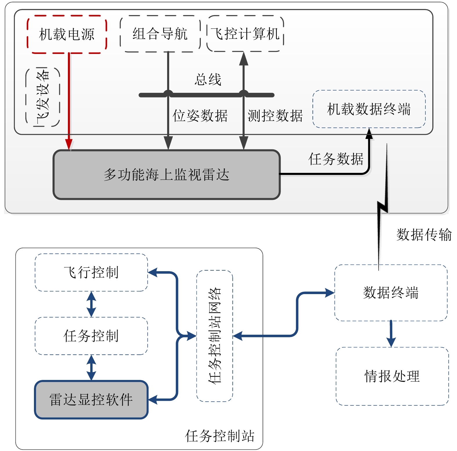
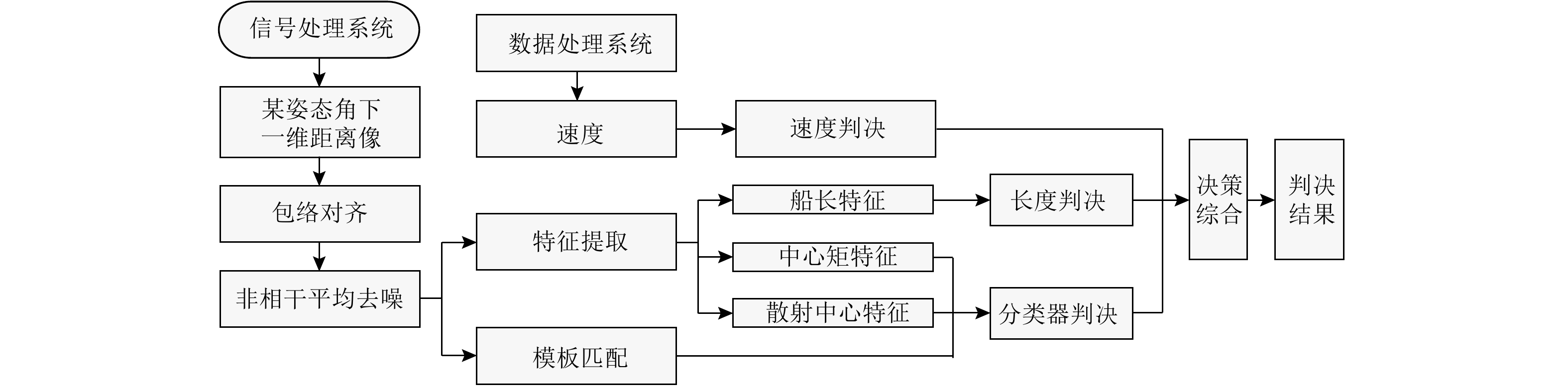
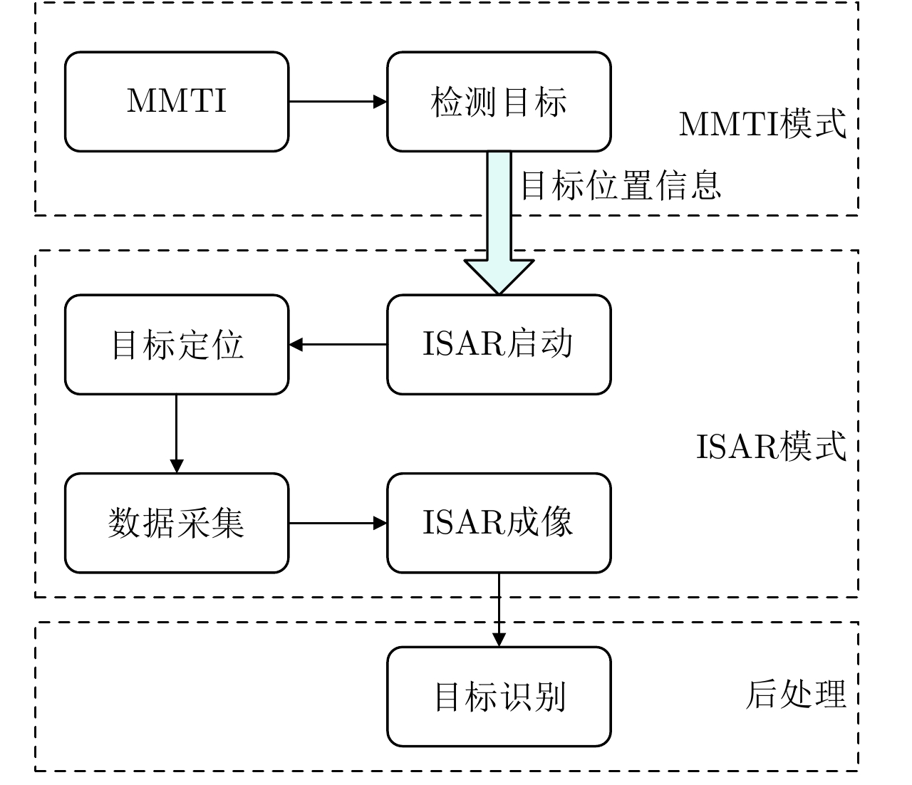
As the main task load of the airborne platform for sea detection, the airborne multi-functional marine surveillance radar system has the following characteristics: the ability to operate in all weather conditions regularly, a wide detection range, and a complex and changeable working environment. Moreover, the system has a wide area coverage, great application prospects, and plays an important role in marine combat. According to the system characteristics and the advantages of the multi-functional marine surveillance radar, the selection of radar system, working parameters, and the working mode design of the system are discussed. The problems of slow target detection, ineffective tracking and target identification in strong sea clutter, which affects the key performance of the system, and technical ways to solve them are analyzed.
As the main task load of the airborne platform for sea detection, the airborne multi-functional marine surveillance radar system has the following characteristics: the ability to operate in all weather conditions regularly, a wide detection range, and a complex and changeable working environment. Moreover, the system has a wide area coverage, great application prospects, and plays an important role in marine combat. According to the system characteristics and the advantages of the multi-functional marine surveillance radar, the selection of radar system, working parameters, and the working mode design of the system are discussed. The problems of slow target detection, ineffective tracking and target identification in strong sea clutter, which affects the key performance of the system, and technical ways to solve them are analyzed.


2019, 8(3): 318-325.
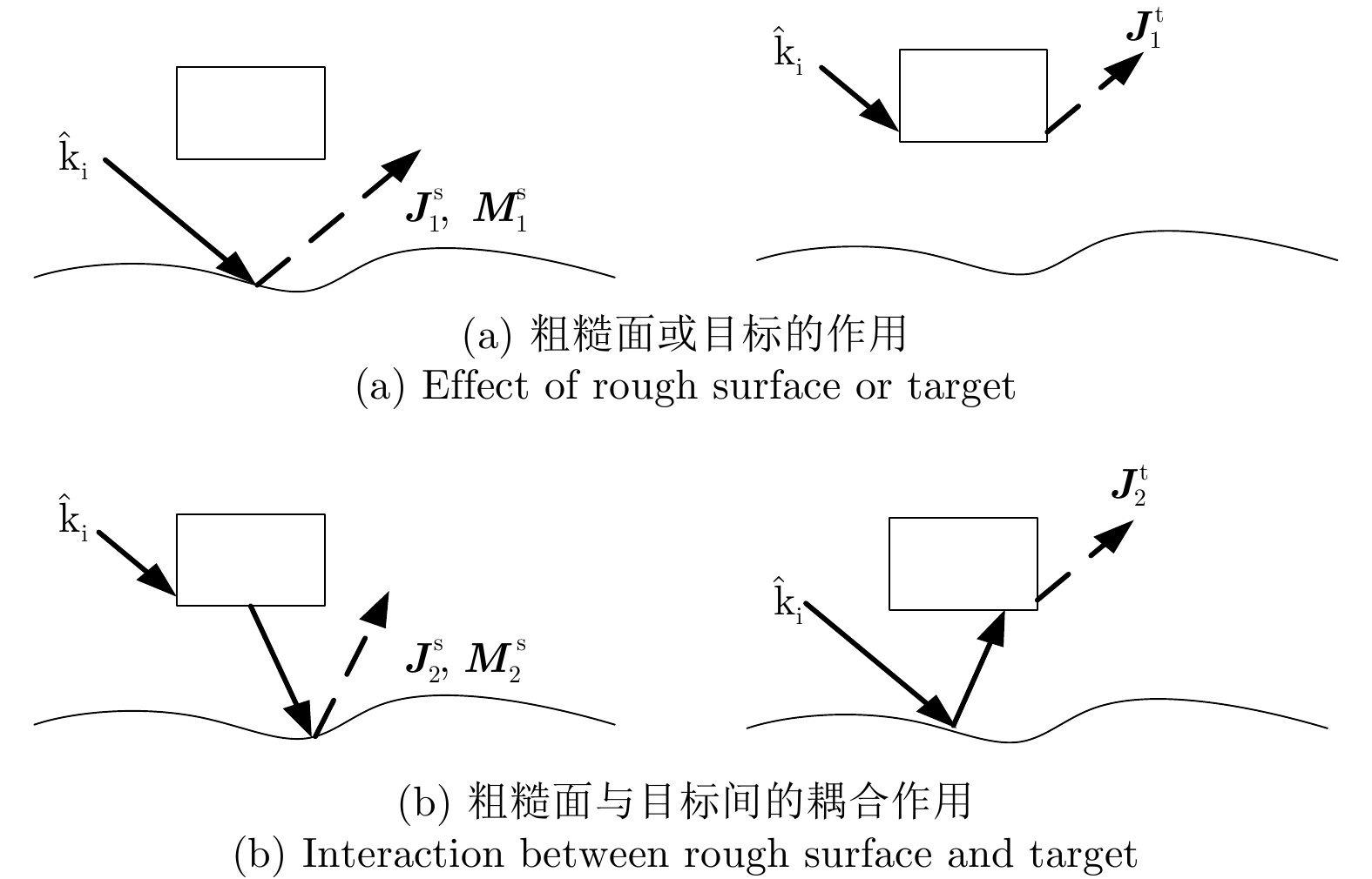
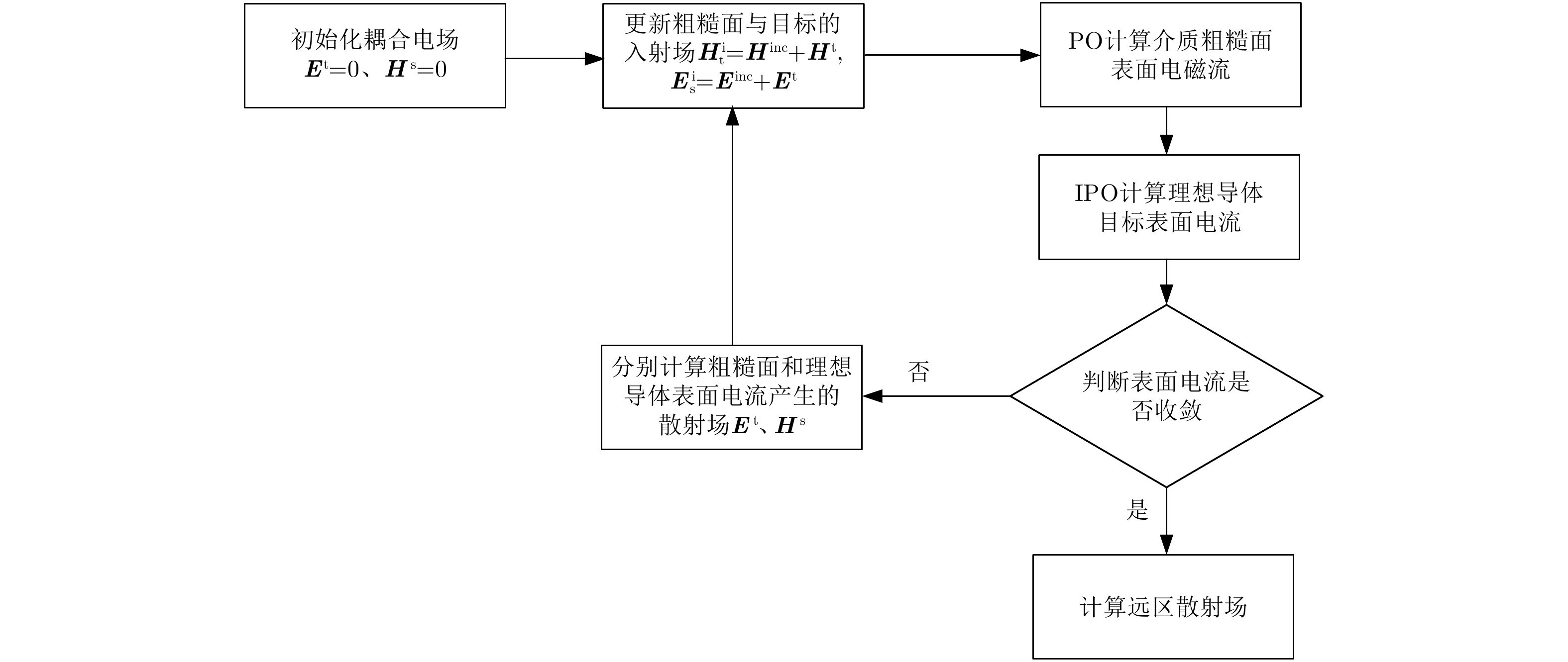
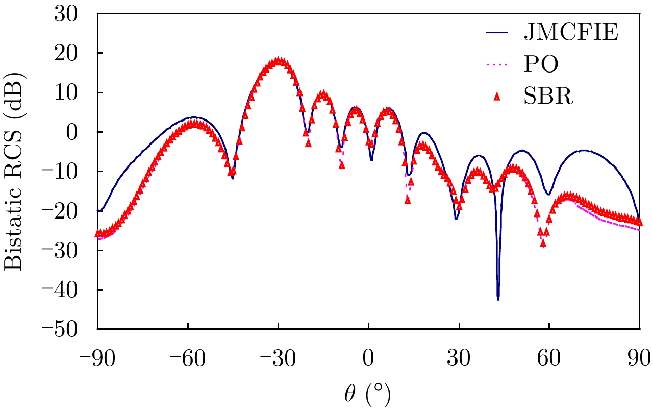
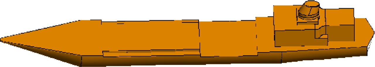
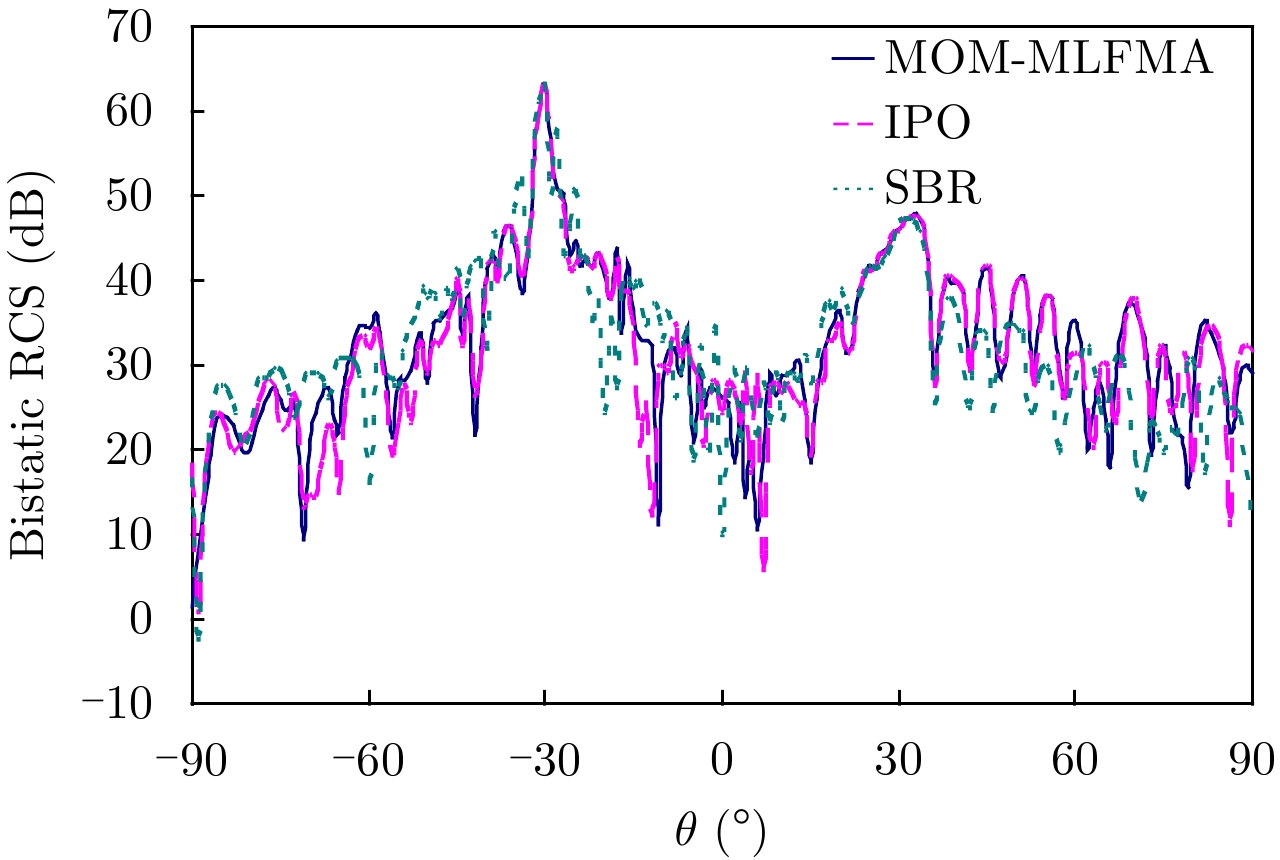
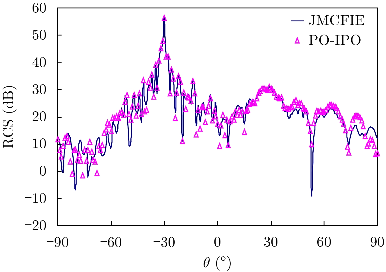
The study on the composite ElectroMagnetic (EM) scattering characteristics of electrically large ships over a random rough surface is significant in the fields of microwave remote sensing, target recognition, and radar imaging. In this paper, an efficient PO-IPO hybrid method is proposed to analyze the scattering from complex targets over the sea surface. The PO method can be used to analyze the scattering from an electrically large sea surface. However, low accuracy will be achieved for targets with complex structures. Therefore, the IPO is applied for computation herein. In the numerical results, several high-frequency methods (PO, IPO, PO-PO, and PO-IPO) are used to analyze the scattering characteristics of targets over the sea surface. Notably, the tapered wave is used as the source in the numerical results, which can restrain the EM reflection and edge diffraction. The results also indicate that the proposed PO-IPO can be used as an efficient tool to obtain the scattering characteristics of complex targets over the sea surface.
The study on the composite ElectroMagnetic (EM) scattering characteristics of electrically large ships over a random rough surface is significant in the fields of microwave remote sensing, target recognition, and radar imaging. In this paper, an efficient PO-IPO hybrid method is proposed to analyze the scattering from complex targets over the sea surface. The PO method can be used to analyze the scattering from an electrically large sea surface. However, low accuracy will be achieved for targets with complex structures. Therefore, the IPO is applied for computation herein. In the numerical results, several high-frequency methods (PO, IPO, PO-PO, and PO-IPO) are used to analyze the scattering characteristics of targets over the sea surface. Notably, the tapered wave is used as the source in the numerical results, which can restrain the EM reflection and edge diffraction. The results also indicate that the proposed PO-IPO can be used as an efficient tool to obtain the scattering characteristics of complex targets over the sea surface.


2019, 8(3): 326-334.
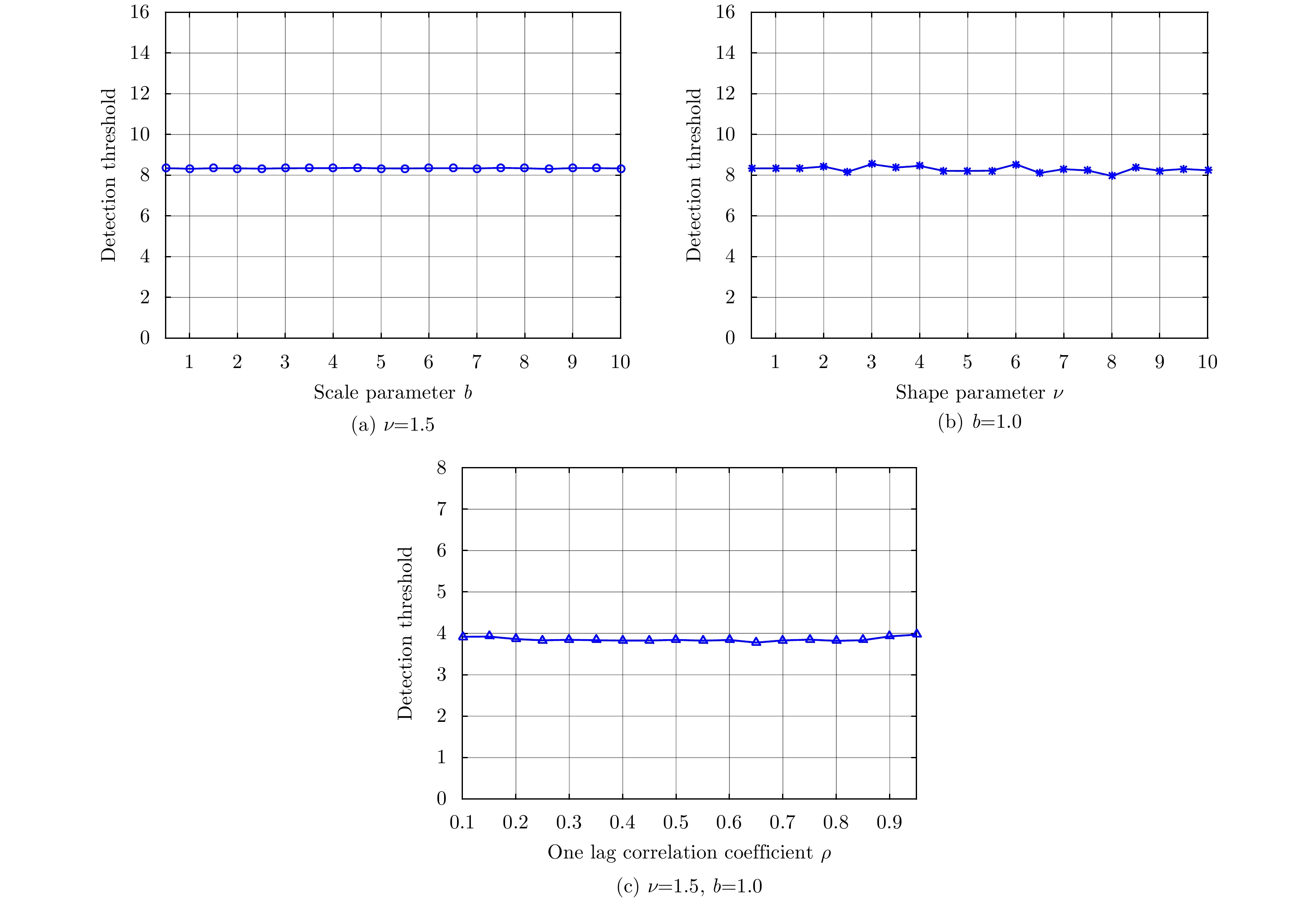
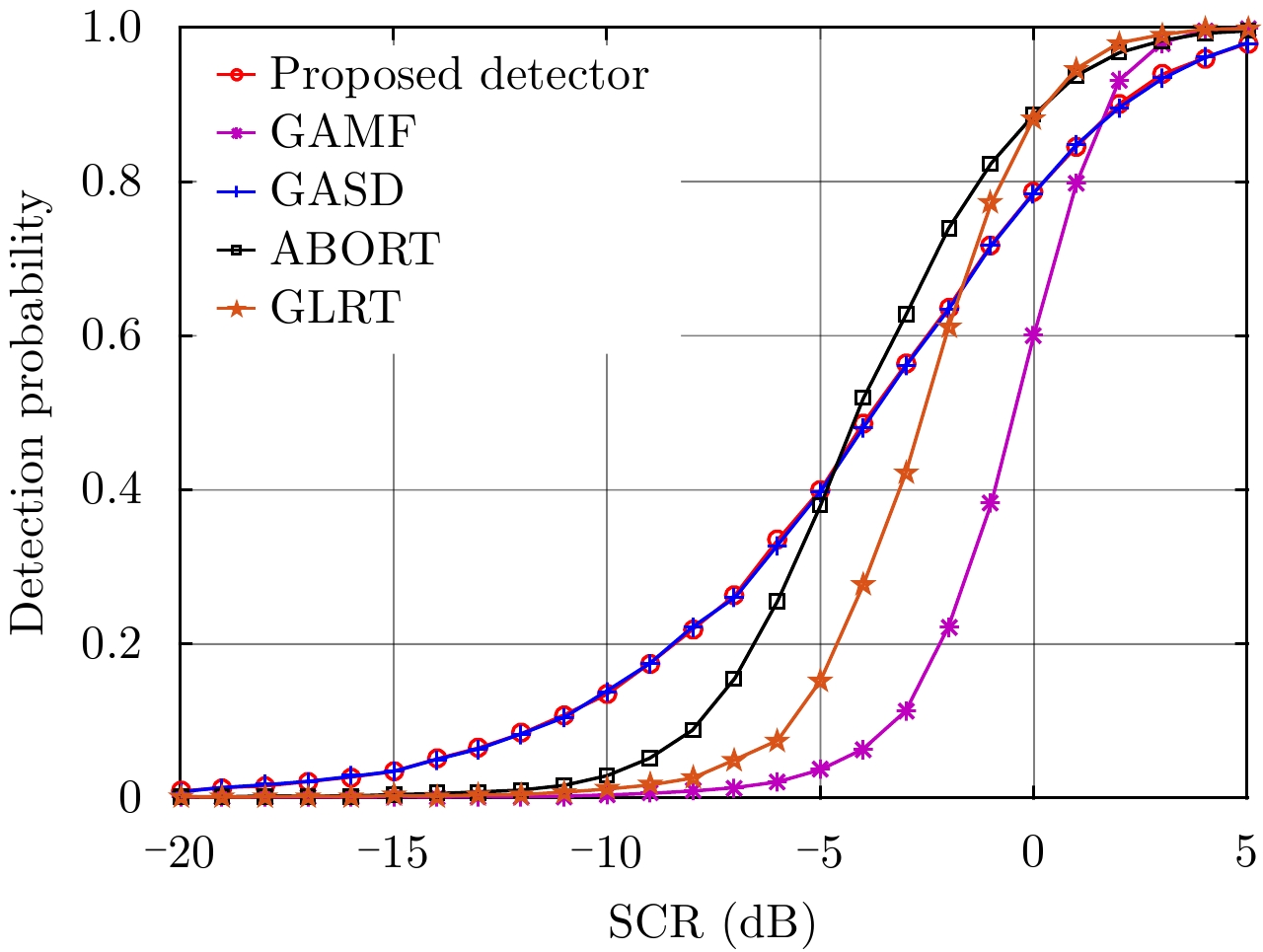
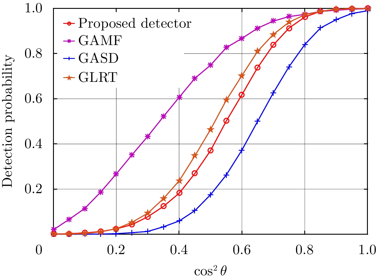
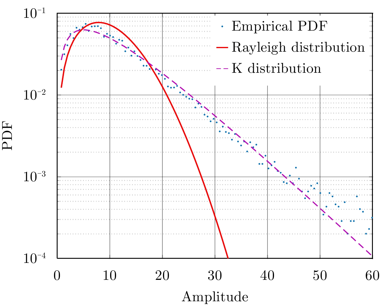
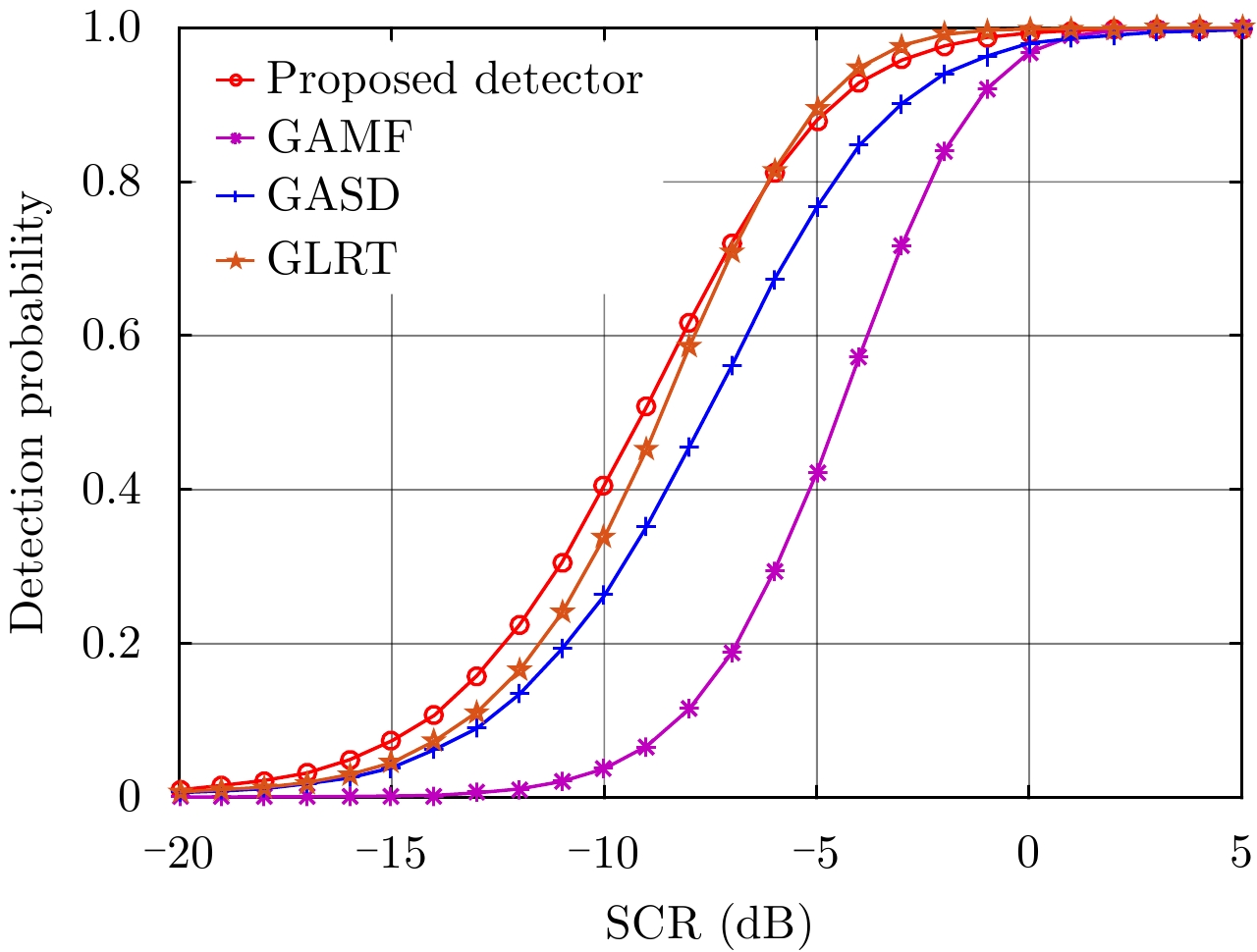
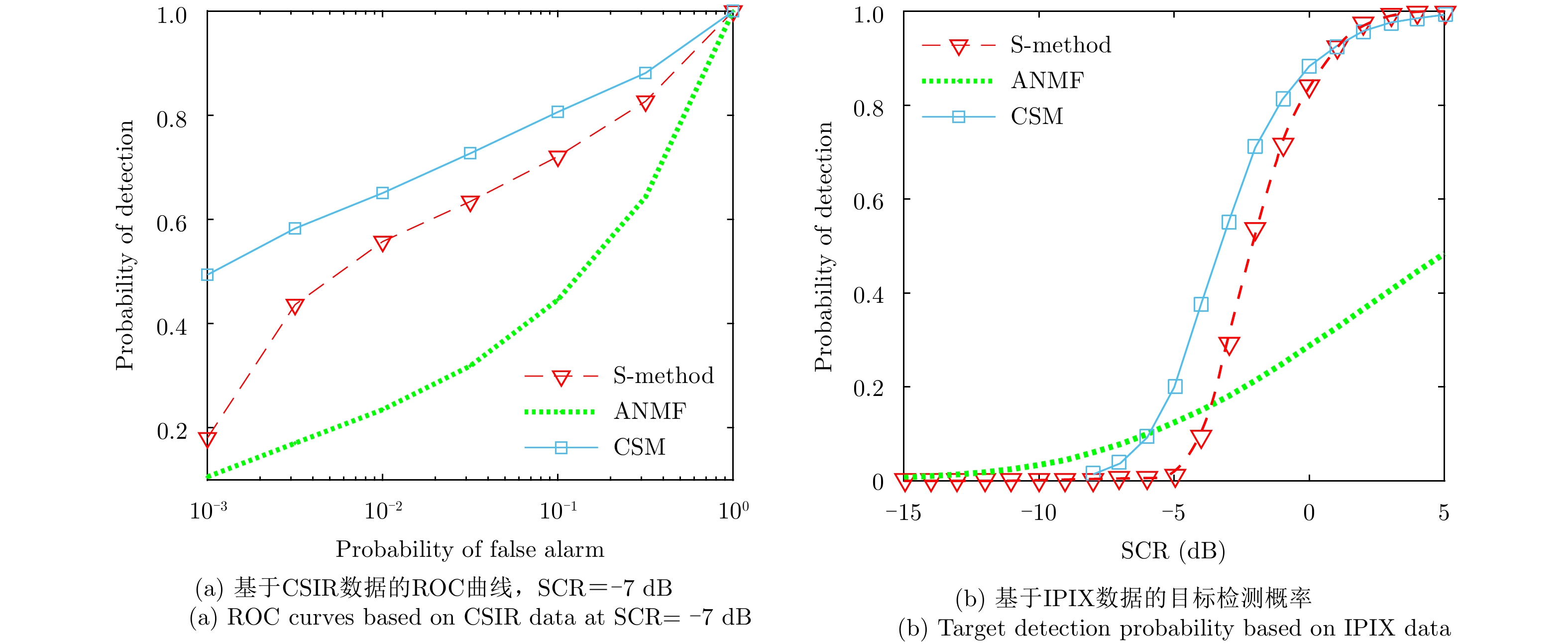
Because of the improvement in radar resolution and decrease in grazing angle, the amplitude distribution of sea clutter obviously deviates from the Rayleigh distribution and presents a significant non-Gaussian feature. In this case, the compound Gaussian model is widely used. This study investigates the problem of detecting a target when signal mismatches occur in compound Gaussian clutter and proposes a selective detector to reject mismatched signals embedded in compound Gaussian clutter based on the so-called two-step Generalized Likelihood Ratio Test (GLRT). To design the selective detector, we modified the original hypothesis test by injecting a fictitious interference under the null hypothesis. These unwanted signals are assumed to be orthogonal to the nominal steering vector in the whitened subspace. The proposed detector has a Constant False Alarm Rate (CFAR) with respect to the statistics of the texture and covariance matrix. Finally, to demonstrate the effectiveness of the proposed detector, a Monte Carlo simulation is conducted to assess its performance based on the simulated and measured sea clutter data. The experimental results show that the proposed detector effectively improves the selectivity of the mismatched signals together with the detection of matched signals in a range spread target of 1~3 dB.
Because of the improvement in radar resolution and decrease in grazing angle, the amplitude distribution of sea clutter obviously deviates from the Rayleigh distribution and presents a significant non-Gaussian feature. In this case, the compound Gaussian model is widely used. This study investigates the problem of detecting a target when signal mismatches occur in compound Gaussian clutter and proposes a selective detector to reject mismatched signals embedded in compound Gaussian clutter based on the so-called two-step Generalized Likelihood Ratio Test (GLRT). To design the selective detector, we modified the original hypothesis test by injecting a fictitious interference under the null hypothesis. These unwanted signals are assumed to be orthogonal to the nominal steering vector in the whitened subspace. The proposed detector has a Constant False Alarm Rate (CFAR) with respect to the statistics of the texture and covariance matrix. Finally, to demonstrate the effectiveness of the proposed detector, a Monte Carlo simulation is conducted to assess its performance based on the simulated and measured sea clutter data. The experimental results show that the proposed detector effectively improves the selectivity of the mismatched signals together with the detection of matched signals in a range spread target of 1~3 dB.


2019, 8(3): 335-343.
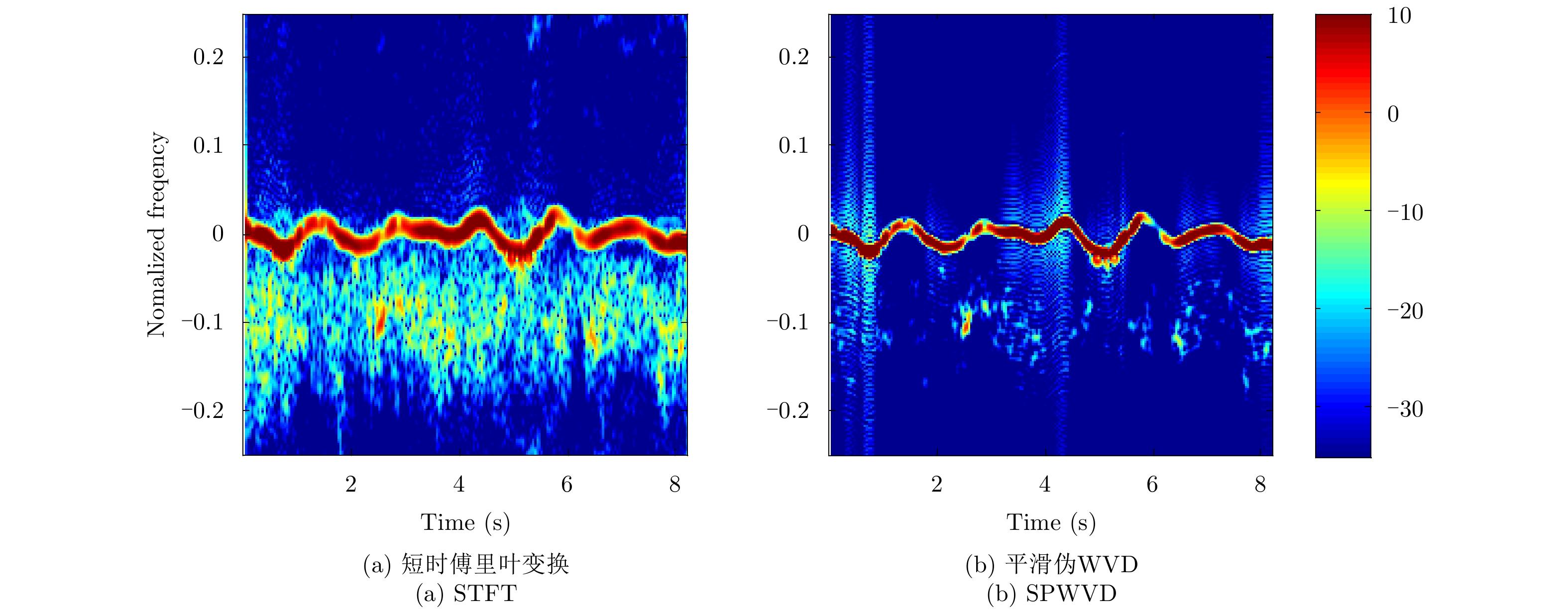
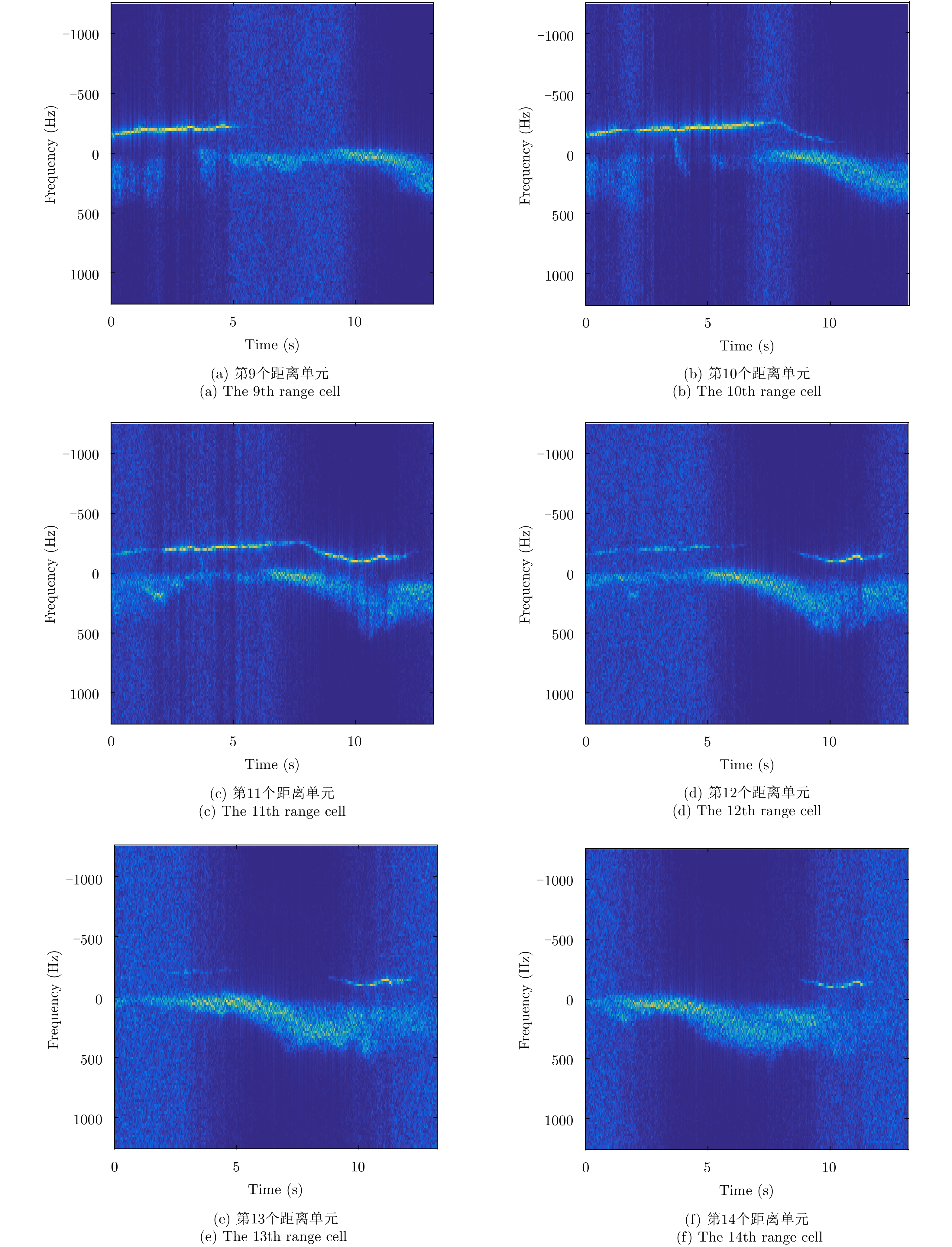
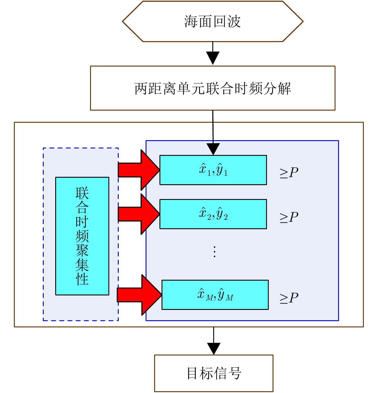
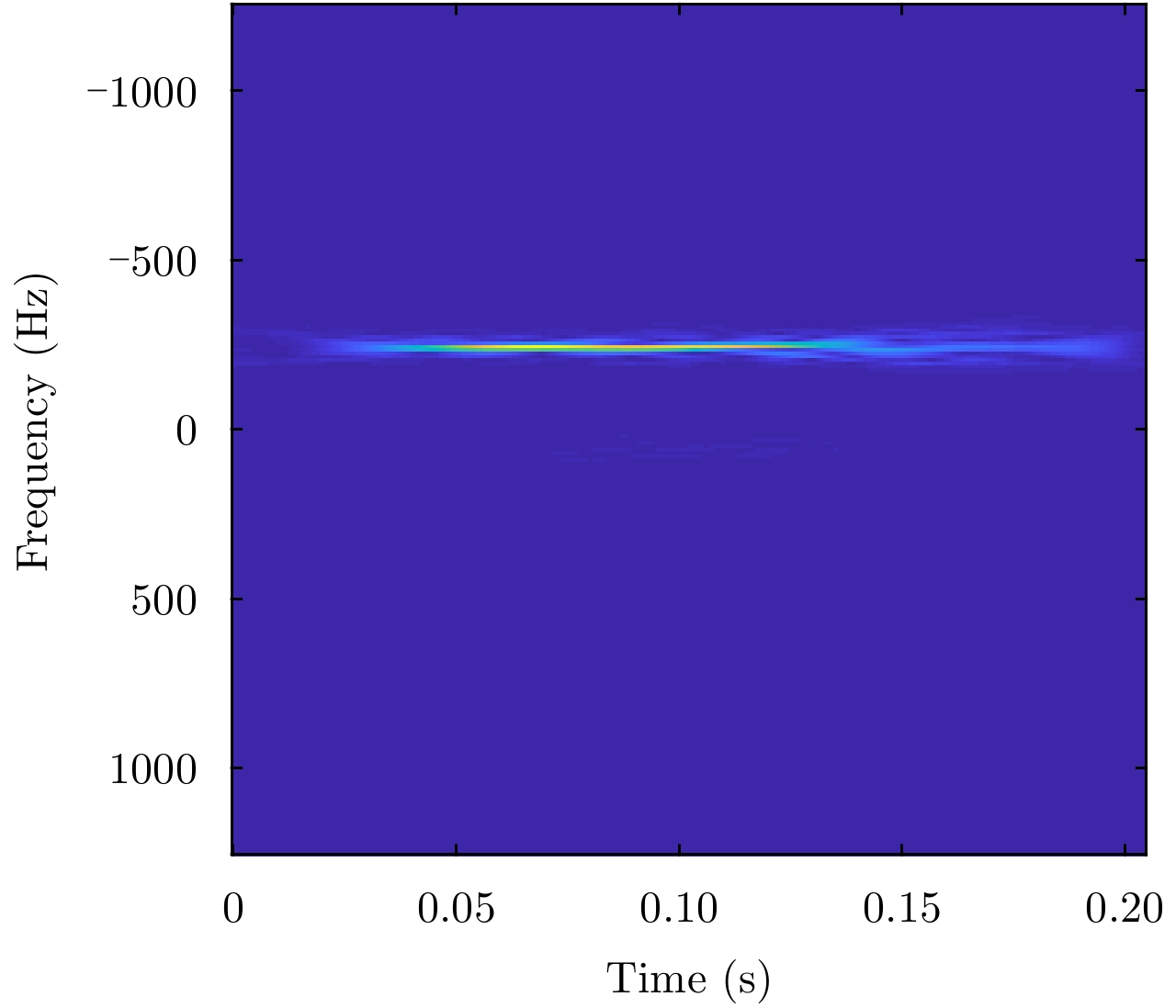
The target on the sea destroys the movement of the sea and affects an area around the target. Therefore, radar echoes from a target on the sea can be found in several successive range cells. Analysis of the echoes shows that the echoes of the target have a long range correlation in space. In this paper, we propose a target detection method by using the joint space-time-frequency decomposition, according to the diffidence between the target echoes and the sea clutter. Therein, the cross S-Method is proposed, which can be considered as the summation of the cross Wigner-Ville representations of the signal components and the sea clutter components, respectively. By using the inverse transform of the cross Wigner-Ville representation, we decompose the echoes from successive range cells. Then a signature, revealing the cross time-frequency concentration, is used to find the signal component in the decomposed signal components. The proposed method is evaluated by the X-band sea echoes with a simulated target or a real target. Results demonstrate that the proposed method not only detects the weak target in high accuracy, but also provides its instantaneous state.
The target on the sea destroys the movement of the sea and affects an area around the target. Therefore, radar echoes from a target on the sea can be found in several successive range cells. Analysis of the echoes shows that the echoes of the target have a long range correlation in space. In this paper, we propose a target detection method by using the joint space-time-frequency decomposition, according to the diffidence between the target echoes and the sea clutter. Therein, the cross S-Method is proposed, which can be considered as the summation of the cross Wigner-Ville representations of the signal components and the sea clutter components, respectively. By using the inverse transform of the cross Wigner-Ville representation, we decompose the echoes from successive range cells. Then a signature, revealing the cross time-frequency concentration, is used to find the signal component in the decomposed signal components. The proposed method is evaluated by the X-band sea echoes with a simulated target or a real target. Results demonstrate that the proposed method not only detects the weak target in high accuracy, but also provides its instantaneous state.


2019, 8(3): 344-354.
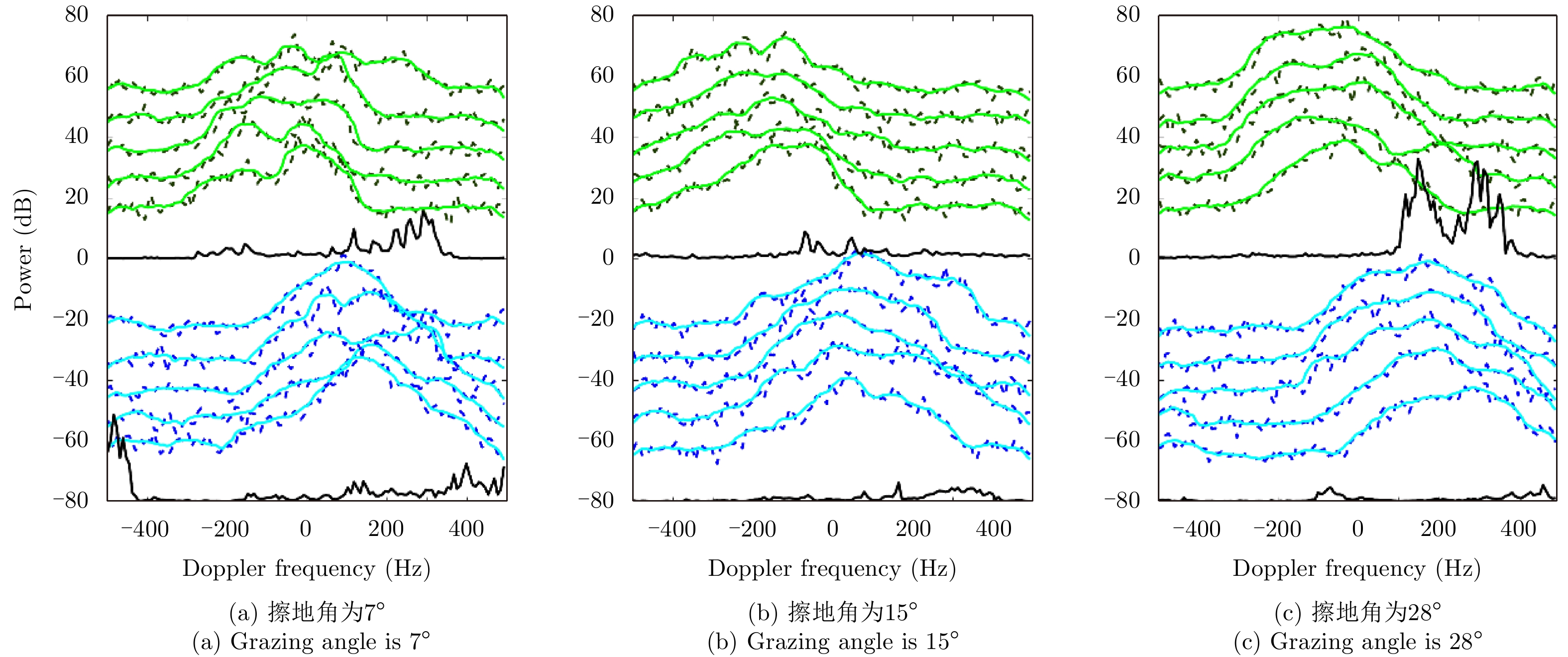
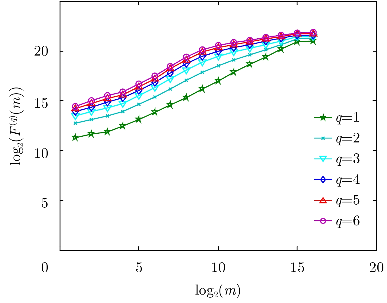
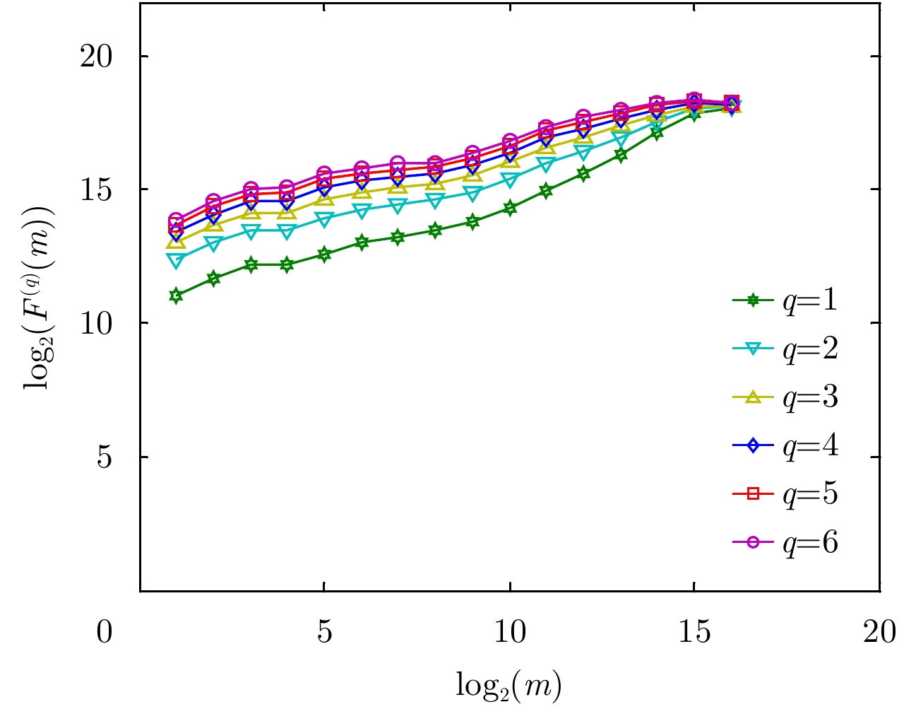
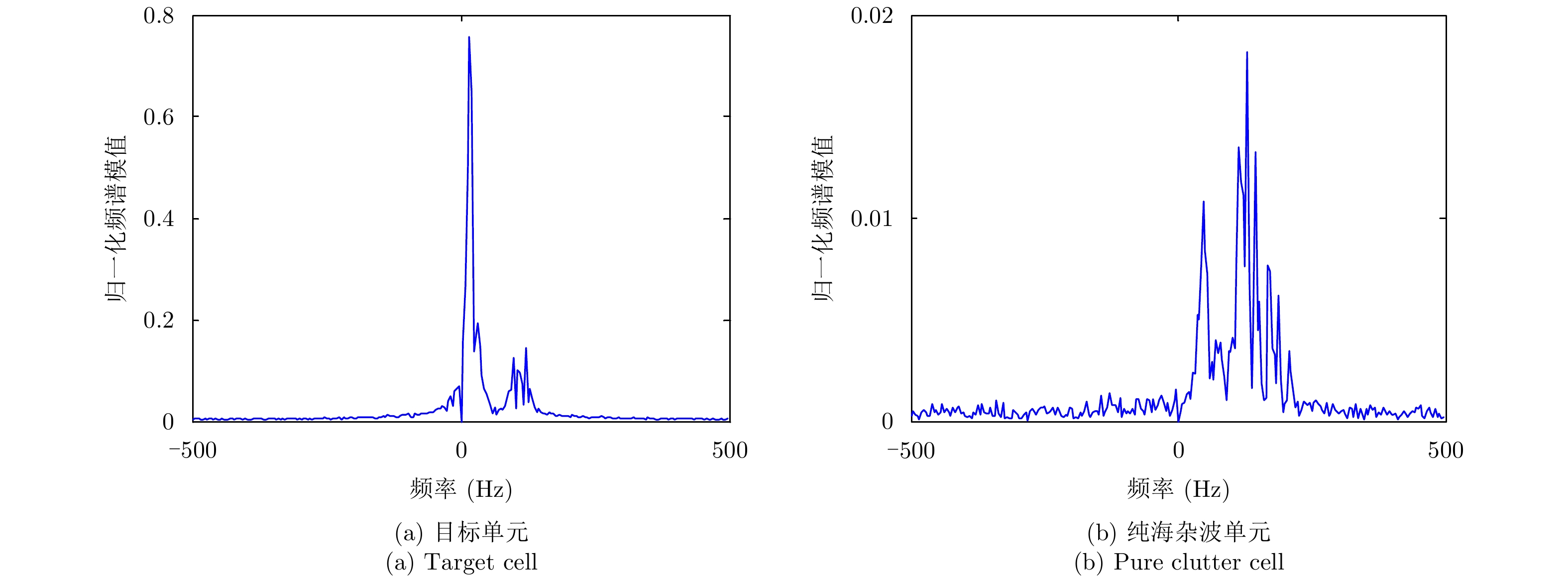
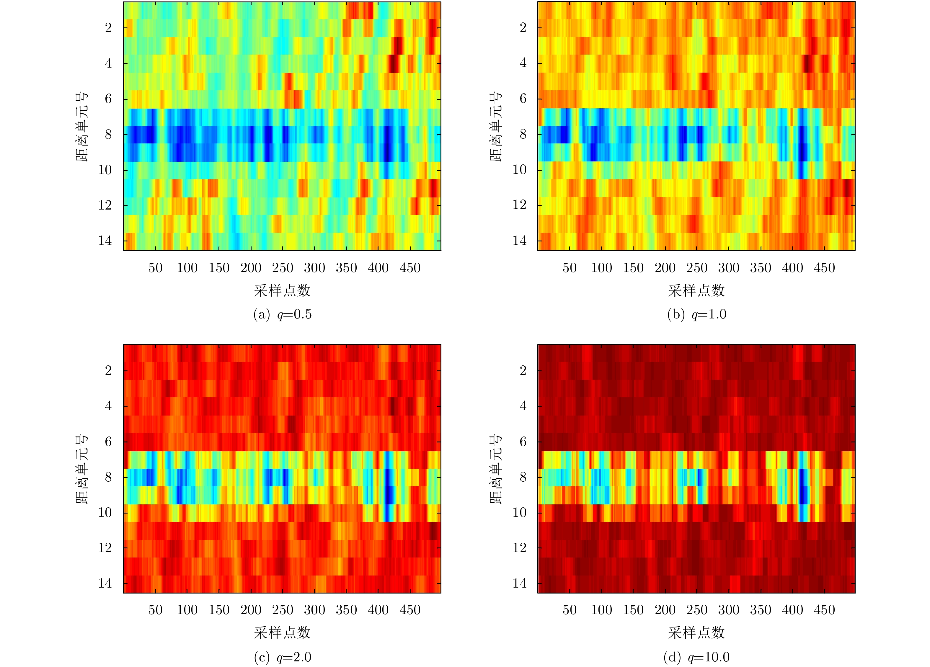
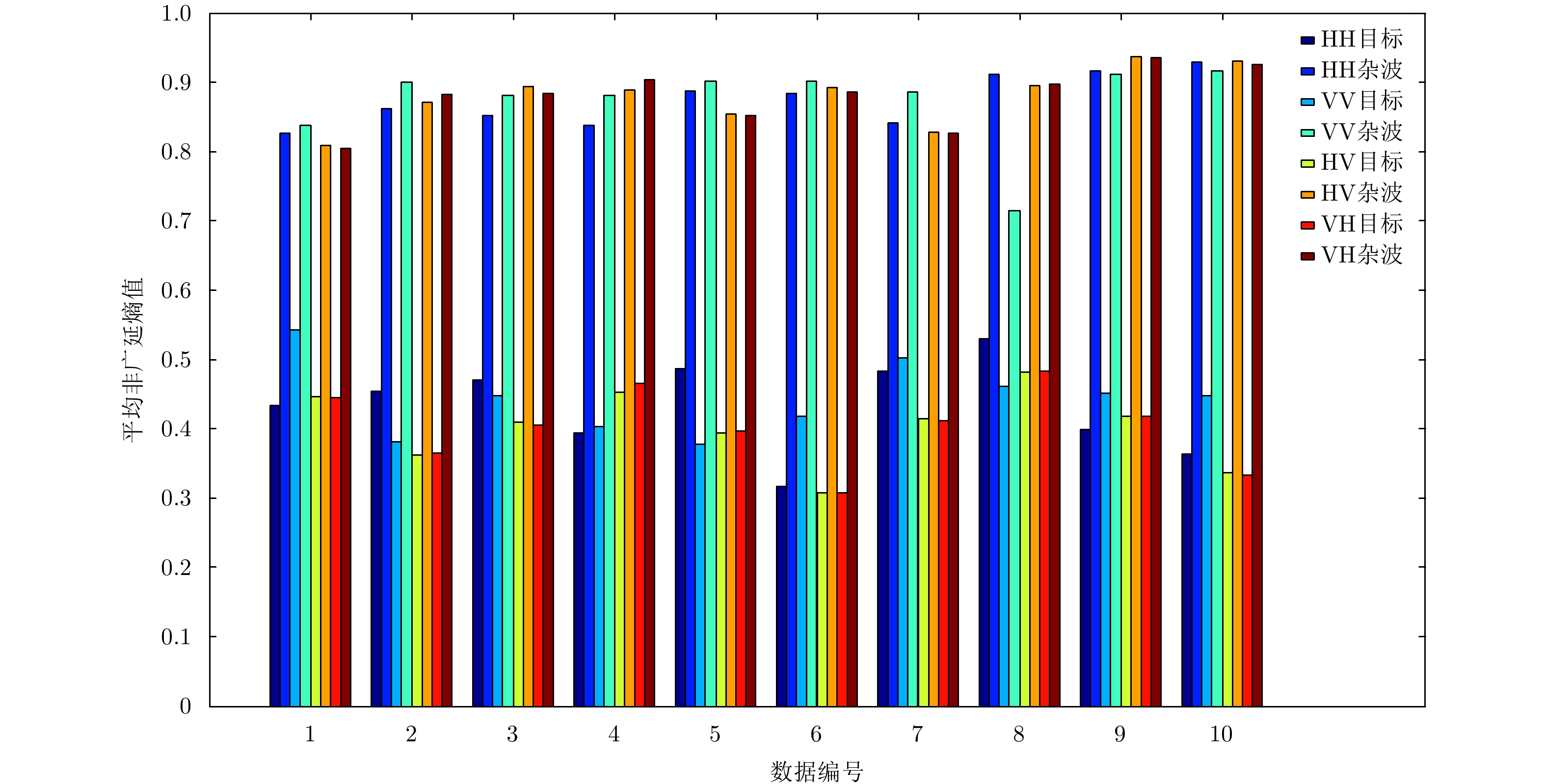
According to the different concentration levels of Doppler spectrum between sea clutter and target, small target in sea clutter background can be detected using Shannon entropy. However, Shannon entropy is merely a special case of Tsallis entropy and cannot reflect the multifractality of sea clutter. In this paper, the relation between Tsallis entropy and the generalized fractal dimension is first presented, and then the Doppler spectrum’s concentrative level and multifractality of sea clutter are combined; finally an algorithm for detecting small target in sea clutter background based on Tsallis entropy of Doppler spectrum rather than of Shannon entropy is proposed. By comparison via IPIX dataset, the detection’s performance of Tsallis entropy is better than that of Shannon entropy and Hurst exponent as per short observations.
According to the different concentration levels of Doppler spectrum between sea clutter and target, small target in sea clutter background can be detected using Shannon entropy. However, Shannon entropy is merely a special case of Tsallis entropy and cannot reflect the multifractality of sea clutter. In this paper, the relation between Tsallis entropy and the generalized fractal dimension is first presented, and then the Doppler spectrum’s concentrative level and multifractality of sea clutter are combined; finally an algorithm for detecting small target in sea clutter background based on Tsallis entropy of Doppler spectrum rather than of Shannon entropy is proposed. By comparison via IPIX dataset, the detection’s performance of Tsallis entropy is better than that of Shannon entropy and Hurst exponent as per short observations.


2019, 8(3): 355-365.
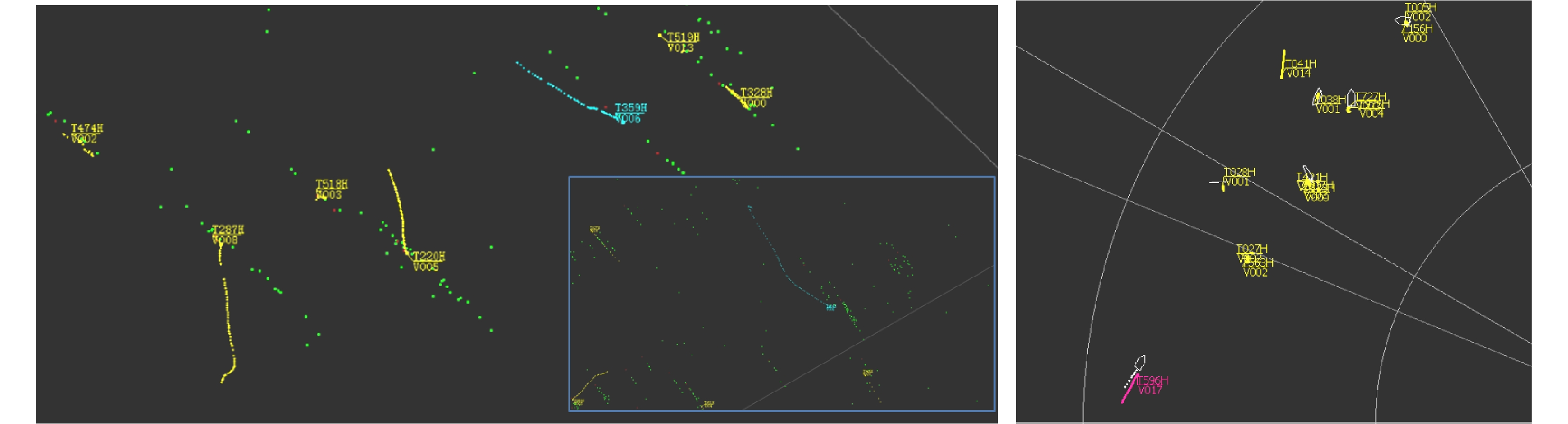
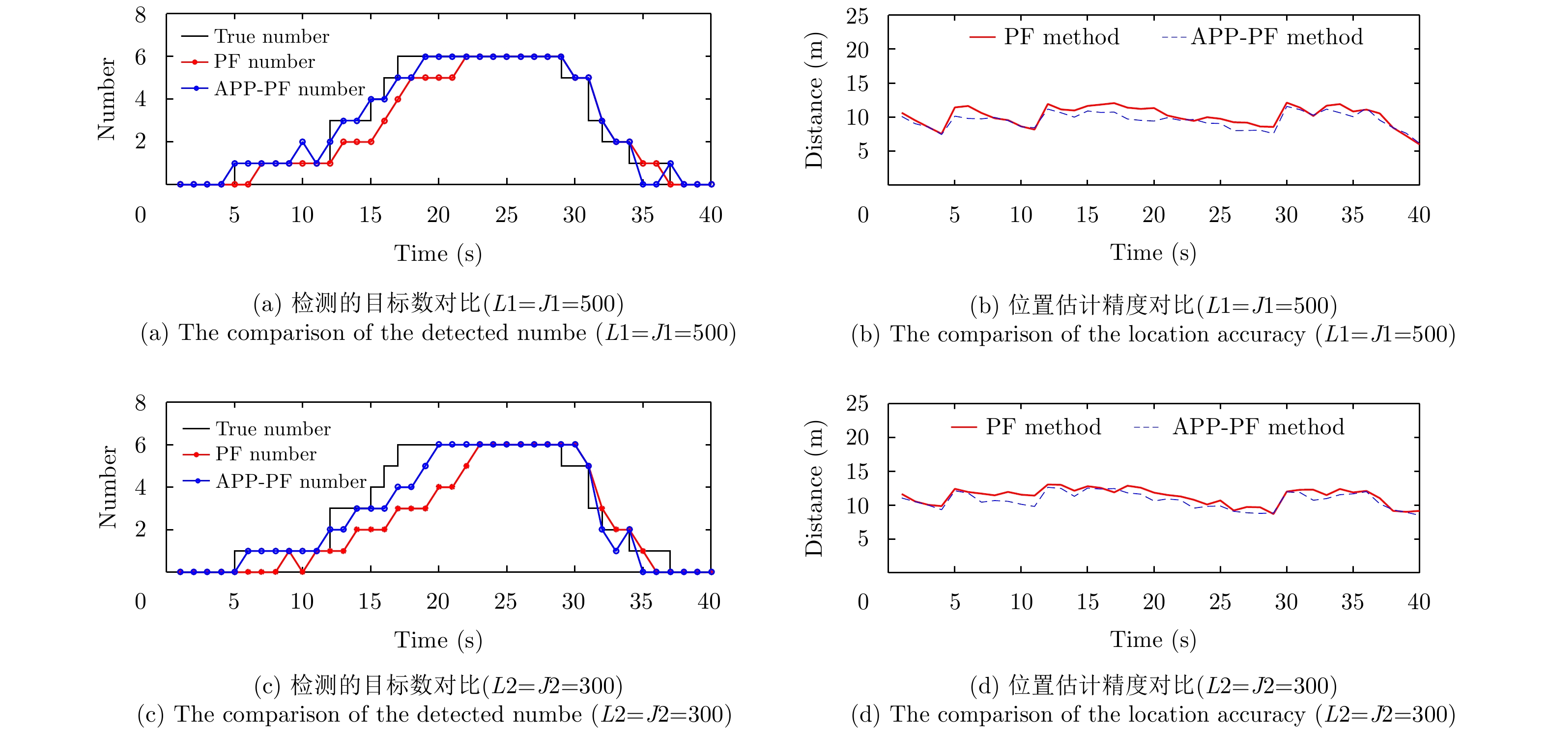
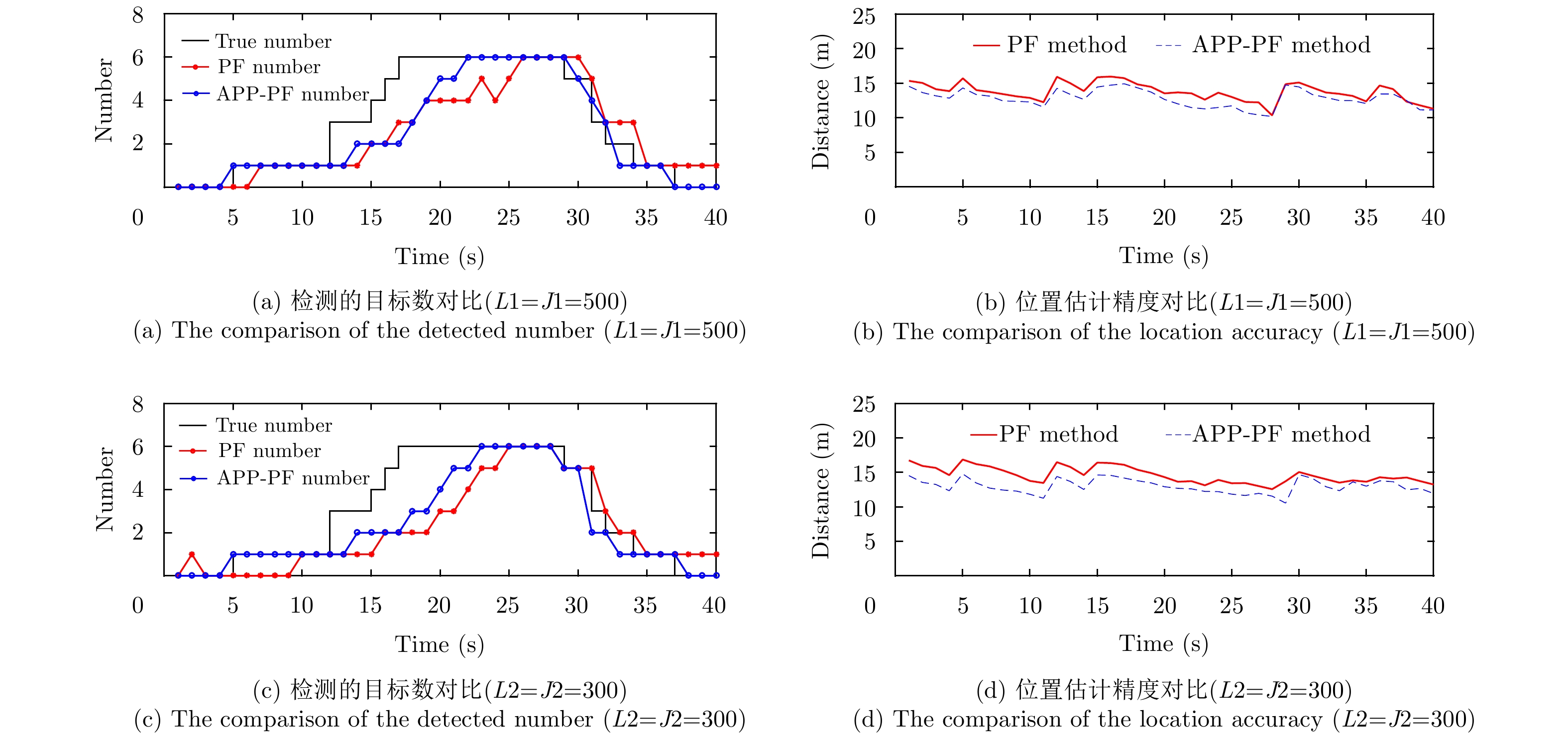
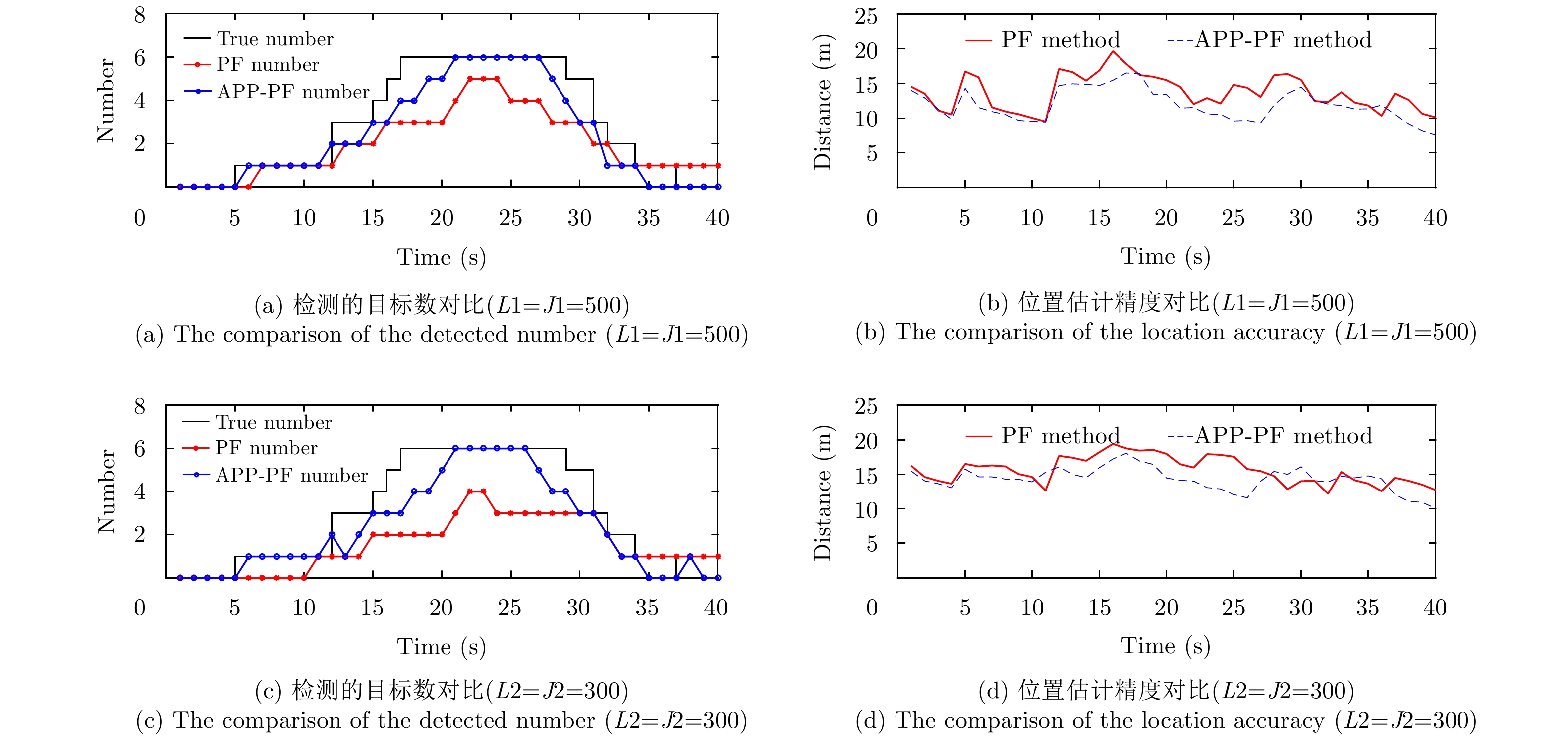
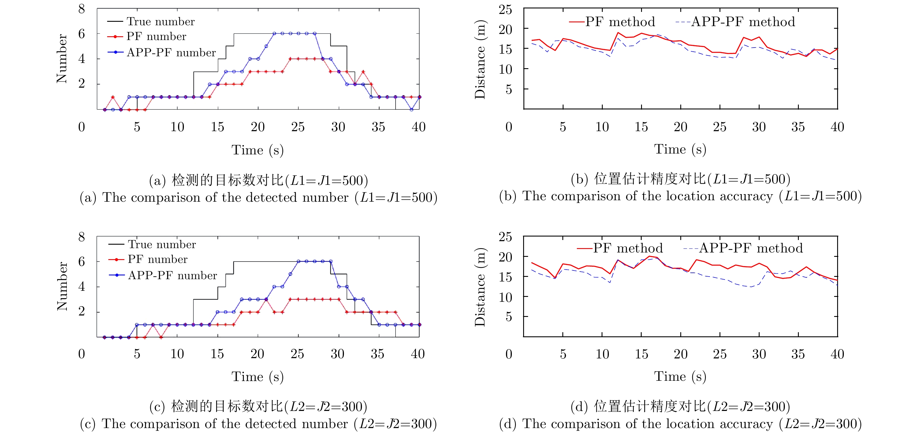
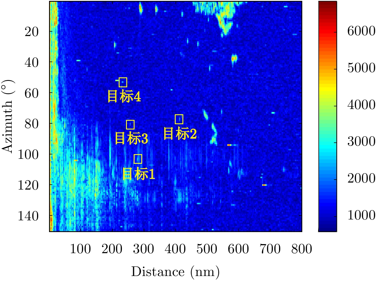
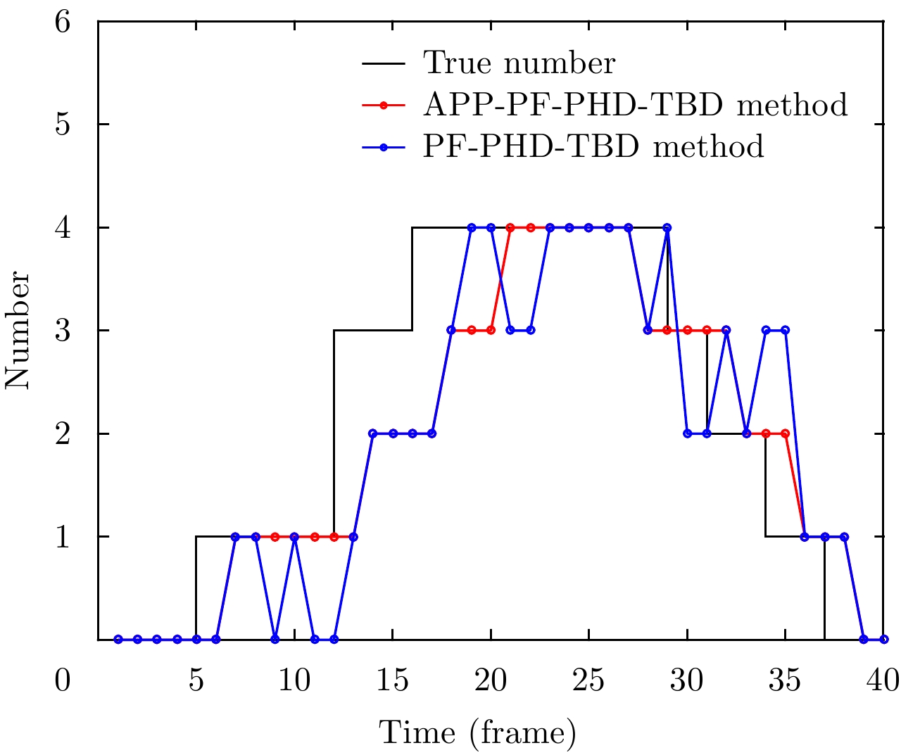
Under the clutter background condition, the existing particle filter pre-detection tracking algorithm based on Probability Hypothesis Density (PHD) filtering is not accurate enough to estimate the number of targets in dense multi-objectives. In this study, the concept of two-layer particle is introduced. The Auxiliary Particle Filter (APF) based on Parallel Partition (PP) theory is applied to PHD-TBD. The Auxiliary Parallel Partition Particle Filter (which is based on APF and PP) Track-Before-Detect based on the Probability Hypothesis Density filter (APP-PF-PHD-TBD) algorithm is proposed to improve the target number and state estimation accuracy. The simulation results show that, compared with the existing PHD-filtering-based particle filter track-before-detect algorithm, the proposed algorithm has significant performance advantages in target number and state estimation accuracy. These advantages are particularly obvious in dense target scenarios. Finally, the sea clutter background data obtained using the navigation radar prove that the proposed algorithm outperforms the existing PHD-filtering-based particle filter track-before-detect algorithm in application.
Under the clutter background condition, the existing particle filter pre-detection tracking algorithm based on Probability Hypothesis Density (PHD) filtering is not accurate enough to estimate the number of targets in dense multi-objectives. In this study, the concept of two-layer particle is introduced. The Auxiliary Particle Filter (APF) based on Parallel Partition (PP) theory is applied to PHD-TBD. The Auxiliary Parallel Partition Particle Filter (which is based on APF and PP) Track-Before-Detect based on the Probability Hypothesis Density filter (APP-PF-PHD-TBD) algorithm is proposed to improve the target number and state estimation accuracy. The simulation results show that, compared with the existing PHD-filtering-based particle filter track-before-detect algorithm, the proposed algorithm has significant performance advantages in target number and state estimation accuracy. These advantages are particularly obvious in dense target scenarios. Finally, the sea clutter background data obtained using the navigation radar prove that the proposed algorithm outperforms the existing PHD-filtering-based particle filter track-before-detect algorithm in application.


2019, 8(3): 366-372.
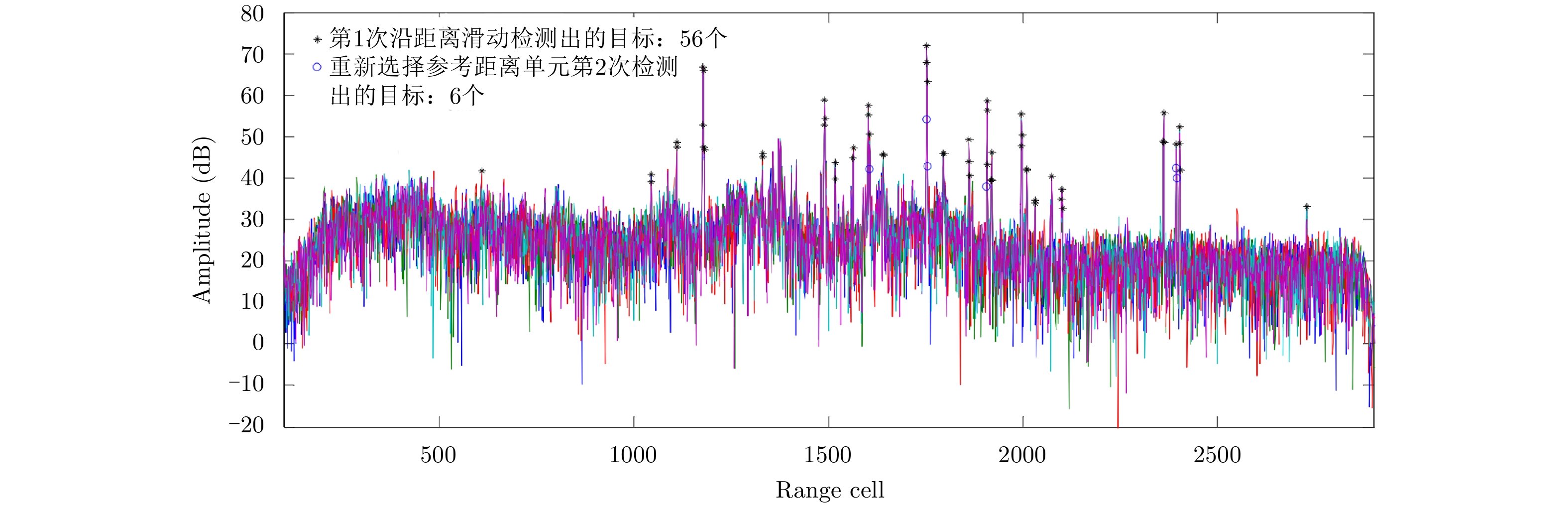
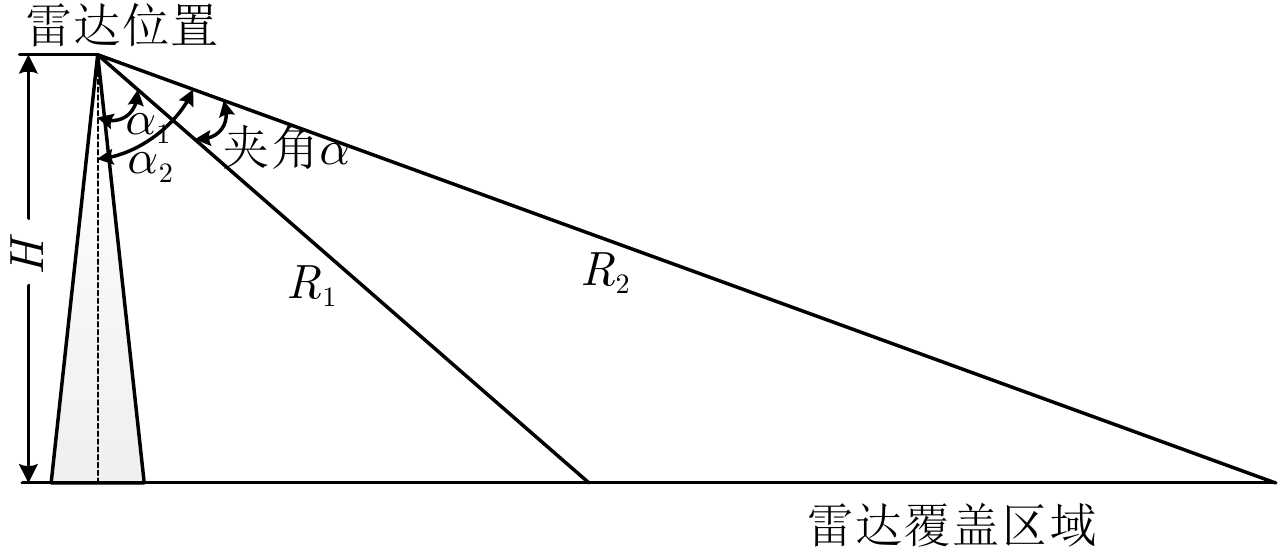
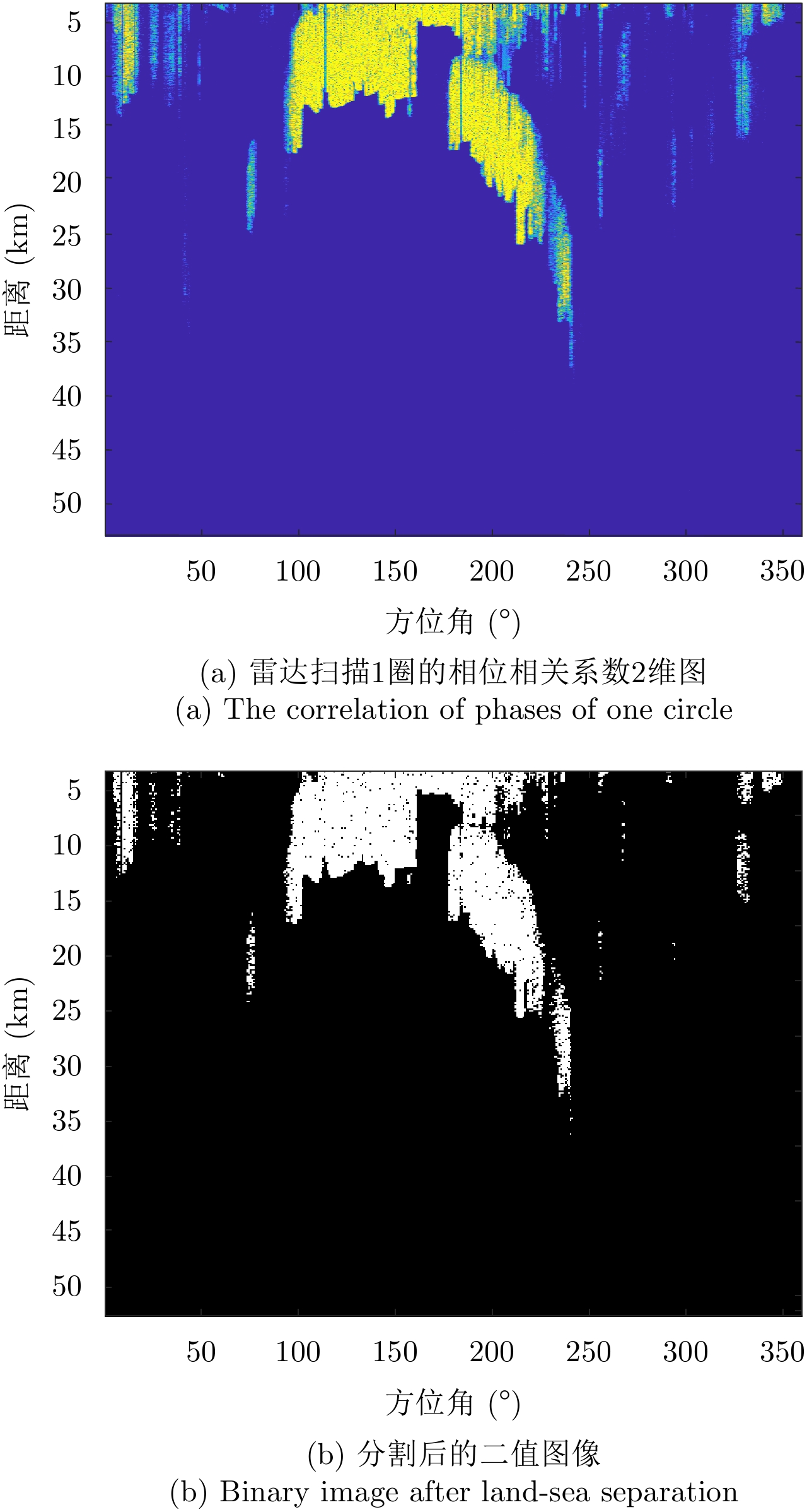
Adaptive detection can effectively improve the detection performance of marine surveillance radars; however, the islands or lands introduce discrete or flaky strong clutter, which may result in wrong covariance matrix estimation. Meanwhile, the complexity of the sea clutter complicates the use of a single model to describe the whole sea clutter. To solve the problem of serious degradation of clutter suppression performance when non-uniform samples participate in covariance matrix estimation and inaccuracy of sea clutter modeling, a land-sea separation and sea surface zoning algorithms are proposed for sea surface target detection. First, the land clutter and sea clutter are distinguished according to the characteristics that the phases of land echo sequences are strongly correlated while the phases of ocean echo sequences are random. Second, the sea surface is zoned according to the rubbing angle; further, the optimal distribution suited for each sea clutter zone is fitted and the appropriate adaptive detection method is selected according to the clutter distribution. Finally, the proposed algorithm is validated based on the measured data of an S-band radar. The results show that the proposed algorithm can effectively improve the detection performance of sea surface targets compared with the traditional detection algorithm.
Adaptive detection can effectively improve the detection performance of marine surveillance radars; however, the islands or lands introduce discrete or flaky strong clutter, which may result in wrong covariance matrix estimation. Meanwhile, the complexity of the sea clutter complicates the use of a single model to describe the whole sea clutter. To solve the problem of serious degradation of clutter suppression performance when non-uniform samples participate in covariance matrix estimation and inaccuracy of sea clutter modeling, a land-sea separation and sea surface zoning algorithms are proposed for sea surface target detection. First, the land clutter and sea clutter are distinguished according to the characteristics that the phases of land echo sequences are strongly correlated while the phases of ocean echo sequences are random. Second, the sea surface is zoned according to the rubbing angle; further, the optimal distribution suited for each sea clutter zone is fitted and the appropriate adaptive detection method is selected according to the clutter distribution. Finally, the proposed algorithm is validated based on the measured data of an S-band radar. The results show that the proposed algorithm can effectively improve the detection performance of sea surface targets compared with the traditional detection algorithm.


2019, 8(3): 373-381.
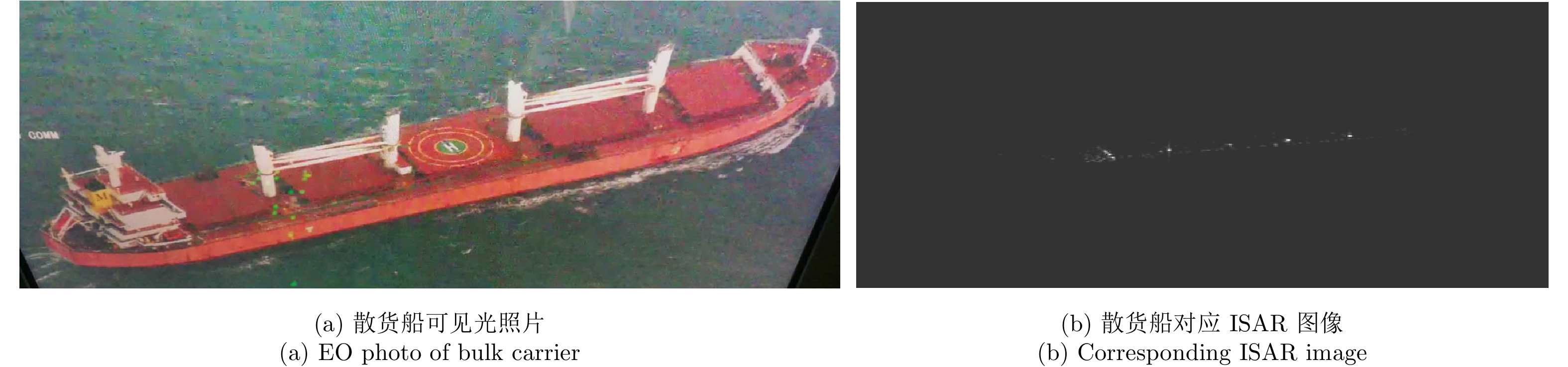
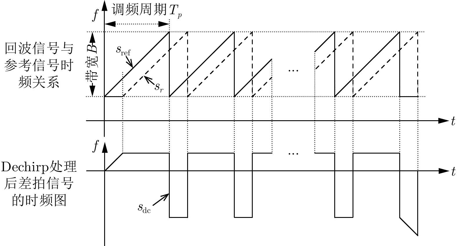
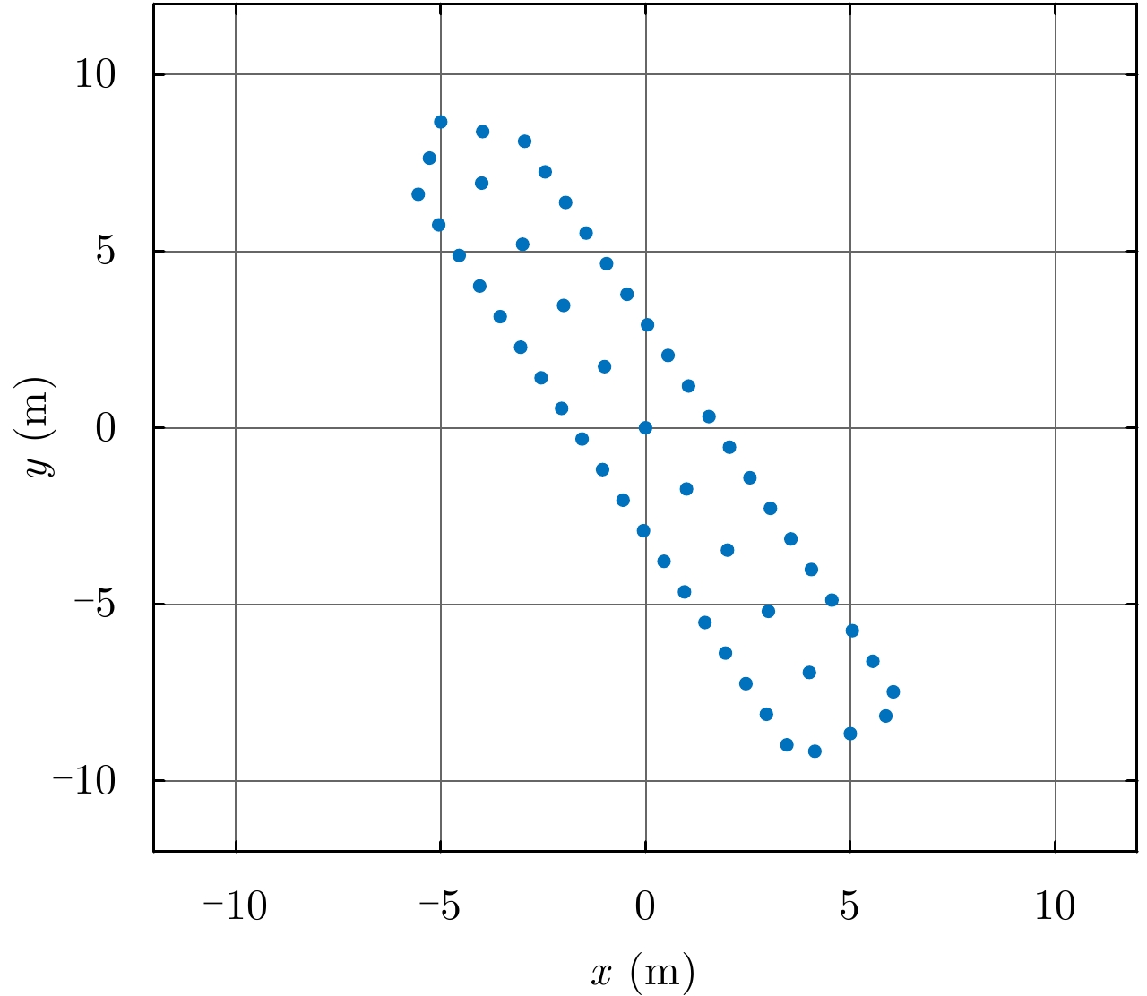
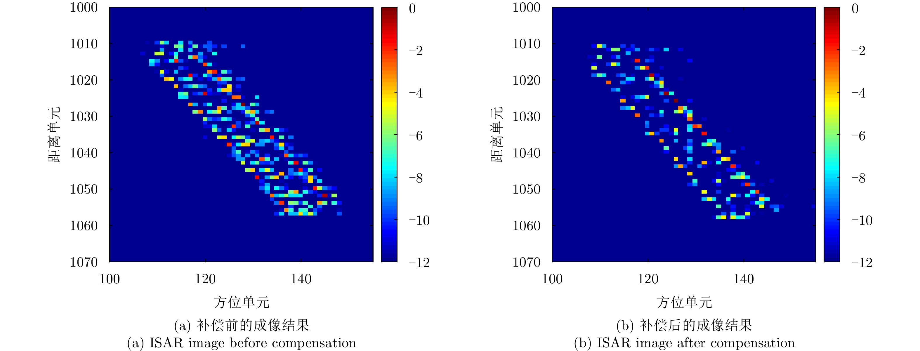
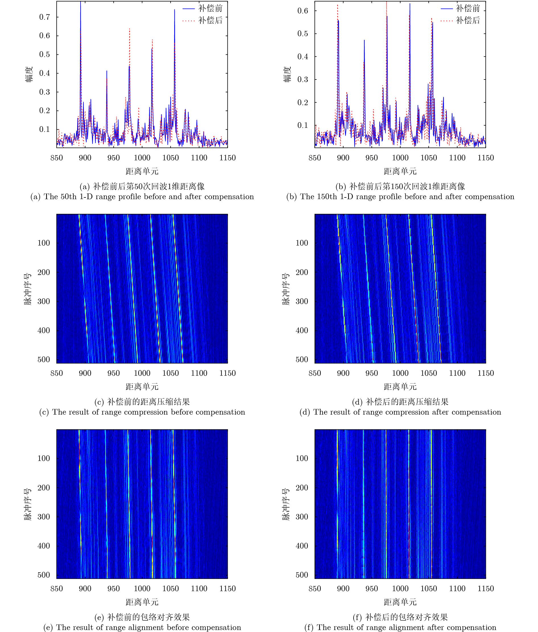
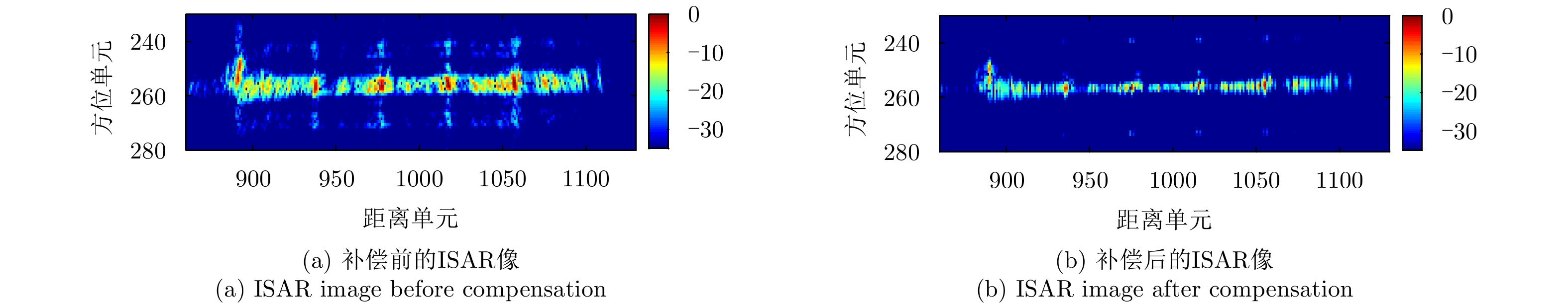
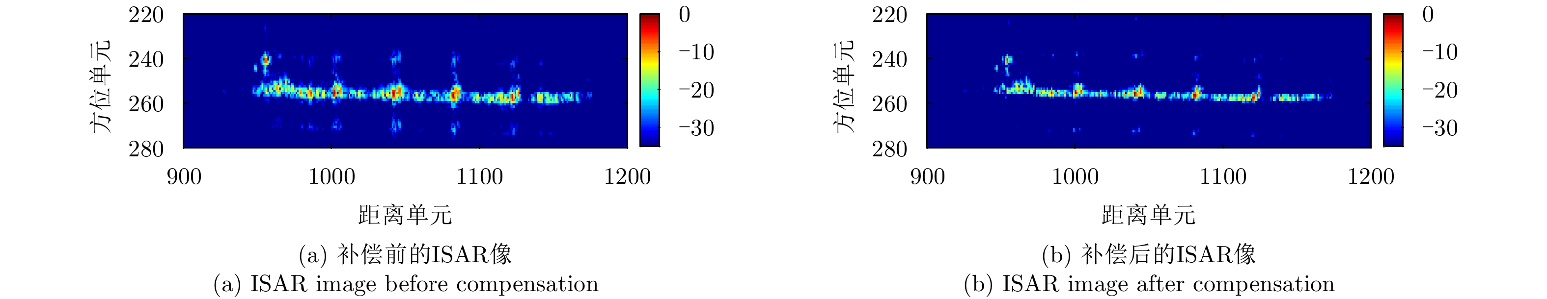
Given its advantages of low cost, low weight, and low power consumption, Frequency Modulated Continuous Wave-Inverse Synthetic Aperture Radar (FMCW-ISAR) has been widely used for imaging many kinds of targets. Since the FMCW signal can be regarded as a pulse signal whose duty ratio is one and pulse duration is relatively long, the motion of targets usually cannot be neglected. In this circumstance, the stop-go assumption is not valid, so ISAR images obtained using the traditional Range-Doppler (R-D) procedure exhibit two-dimensional blurring, which results in decreased resolution. In this paper, we investigate the blur problems of FMCW-ISAR in imaging ship targets, and construct a target motion model. Then, we analyze the influence of the in-pulse motion component in range profiles and final images. We propose a corresponding in-pulse compensation method to improve the resolution of ISAR images. A comparison with the imaging results of real measured echo data verifies the effectiveness of the proposed method in diminishing the 1-D-profile broadening and improving image quality.
Given its advantages of low cost, low weight, and low power consumption, Frequency Modulated Continuous Wave-Inverse Synthetic Aperture Radar (FMCW-ISAR) has been widely used for imaging many kinds of targets. Since the FMCW signal can be regarded as a pulse signal whose duty ratio is one and pulse duration is relatively long, the motion of targets usually cannot be neglected. In this circumstance, the stop-go assumption is not valid, so ISAR images obtained using the traditional Range-Doppler (R-D) procedure exhibit two-dimensional blurring, which results in decreased resolution. In this paper, we investigate the blur problems of FMCW-ISAR in imaging ship targets, and construct a target motion model. Then, we analyze the influence of the in-pulse motion component in range profiles and final images. We propose a corresponding in-pulse compensation method to improve the resolution of ISAR images. A comparison with the imaging results of real measured echo data verifies the effectiveness of the proposed method in diminishing the 1-D-profile broadening and improving image quality.


2019, 8(3): 382-390.
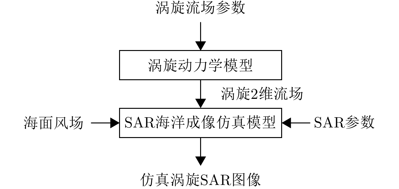
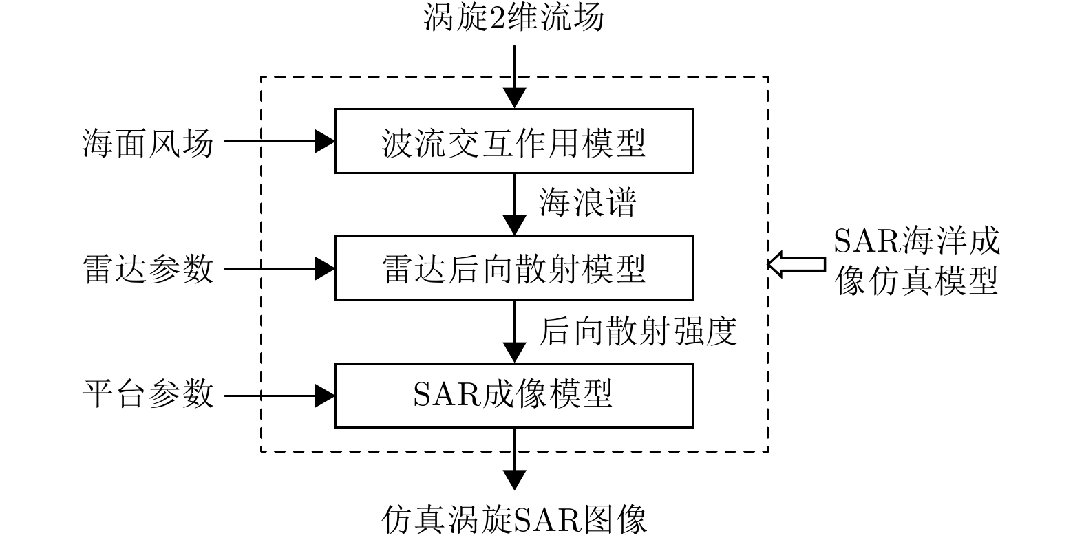
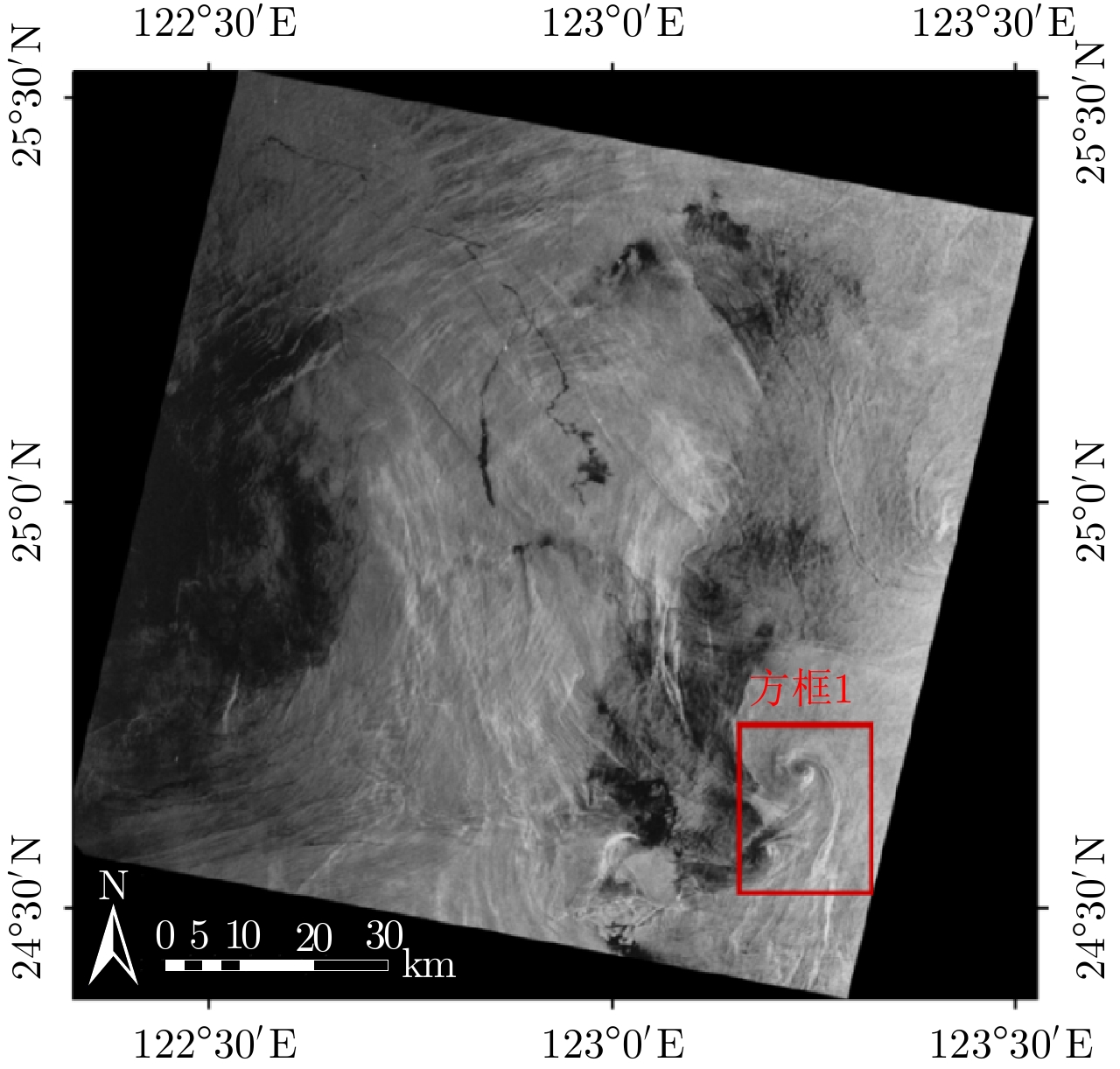
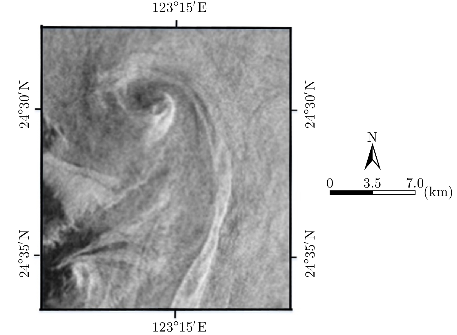
Oceanic eddies, which play an important role in ocean thermal cycling, is a significant branch of oceanic scientific research. Synthetic Aperture Radar (SAR) provides a large number of images for the observation and investigation of oceanic eddies. However, SAR imagery of oceanic eddies is affected by various environmental factors; as such, it is difficult to interpret eddy features from SAR images. Alternatively, simulated SAR images can be used to investigate eddy features; however, few methods have been established for simulating SAR images for oceanic eddies. To better interpret the eddy features in real SAR images, an SAR image simulation method for oceanic eddies is proposed in this paper. First, a two-dimensional eddy surface current field was built based on the Burgers-Rott vortex model in hydrodynamics; SAR eddy images were then simulated according to the given eddy current field, wind field, and radar parameters. Images of cyclonic and anticyclonic eddies were simulated and evaluated. In addition, a standard for evaluating the similarity between real and simulated SAR eddy images was established. The features of the simulated SAR eddy images show good similarity with the real SAR eddy images, which validates the effectiveness of the proposed simulation method.
Oceanic eddies, which play an important role in ocean thermal cycling, is a significant branch of oceanic scientific research. Synthetic Aperture Radar (SAR) provides a large number of images for the observation and investigation of oceanic eddies. However, SAR imagery of oceanic eddies is affected by various environmental factors; as such, it is difficult to interpret eddy features from SAR images. Alternatively, simulated SAR images can be used to investigate eddy features; however, few methods have been established for simulating SAR images for oceanic eddies. To better interpret the eddy features in real SAR images, an SAR image simulation method for oceanic eddies is proposed in this paper. First, a two-dimensional eddy surface current field was built based on the Burgers-Rott vortex model in hydrodynamics; SAR eddy images were then simulated according to the given eddy current field, wind field, and radar parameters. Images of cyclonic and anticyclonic eddies were simulated and evaluated. In addition, a standard for evaluating the similarity between real and simulated SAR eddy images was established. The features of the simulated SAR eddy images show good similarity with the real SAR eddy images, which validates the effectiveness of the proposed simulation method.


2019, 8(3): 391-399.
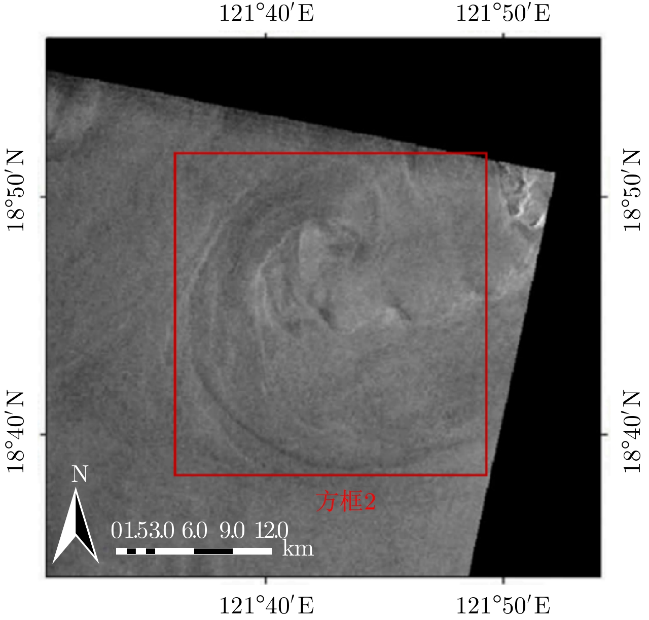
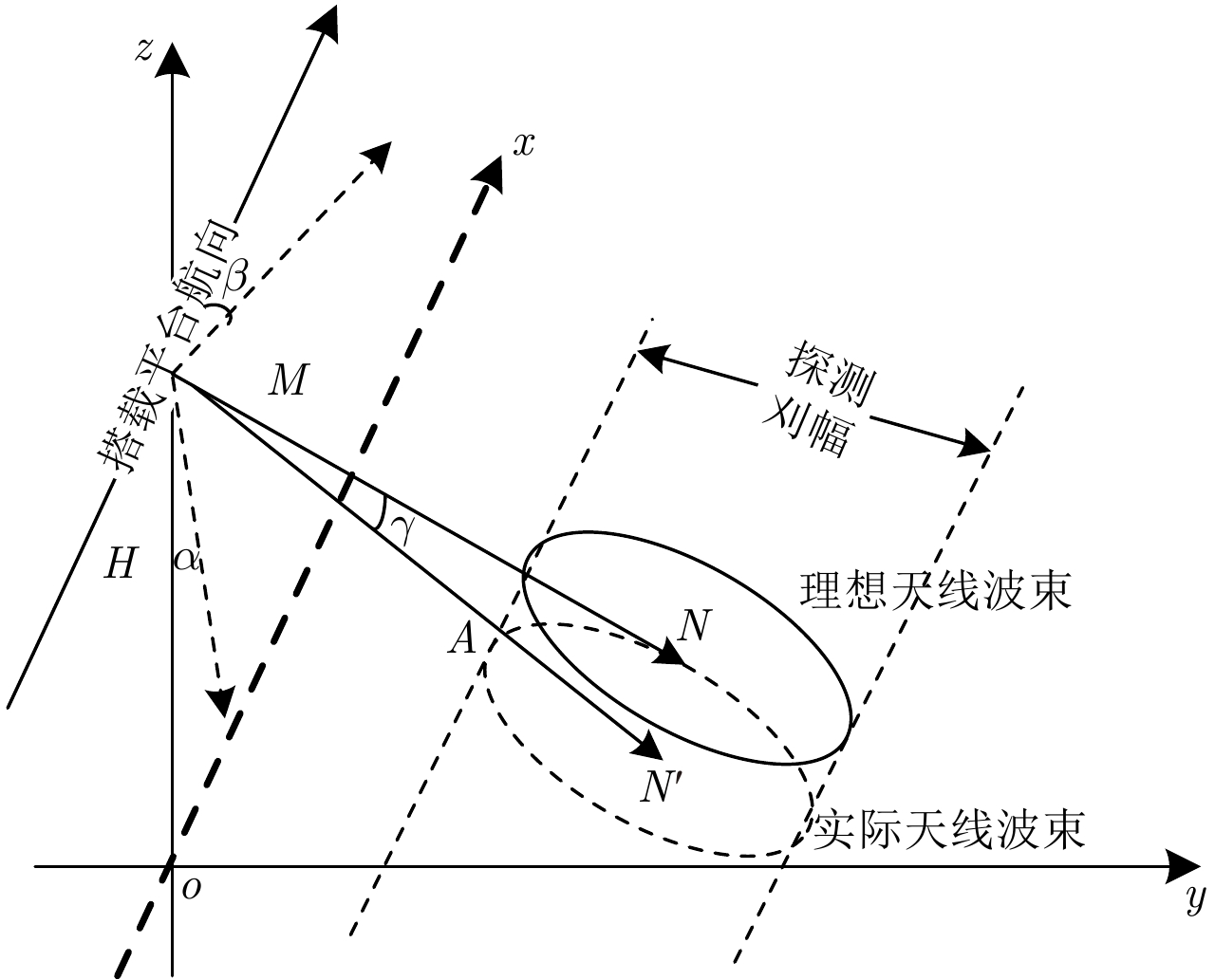
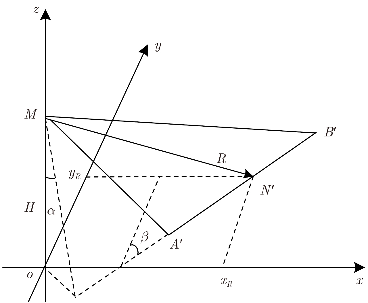
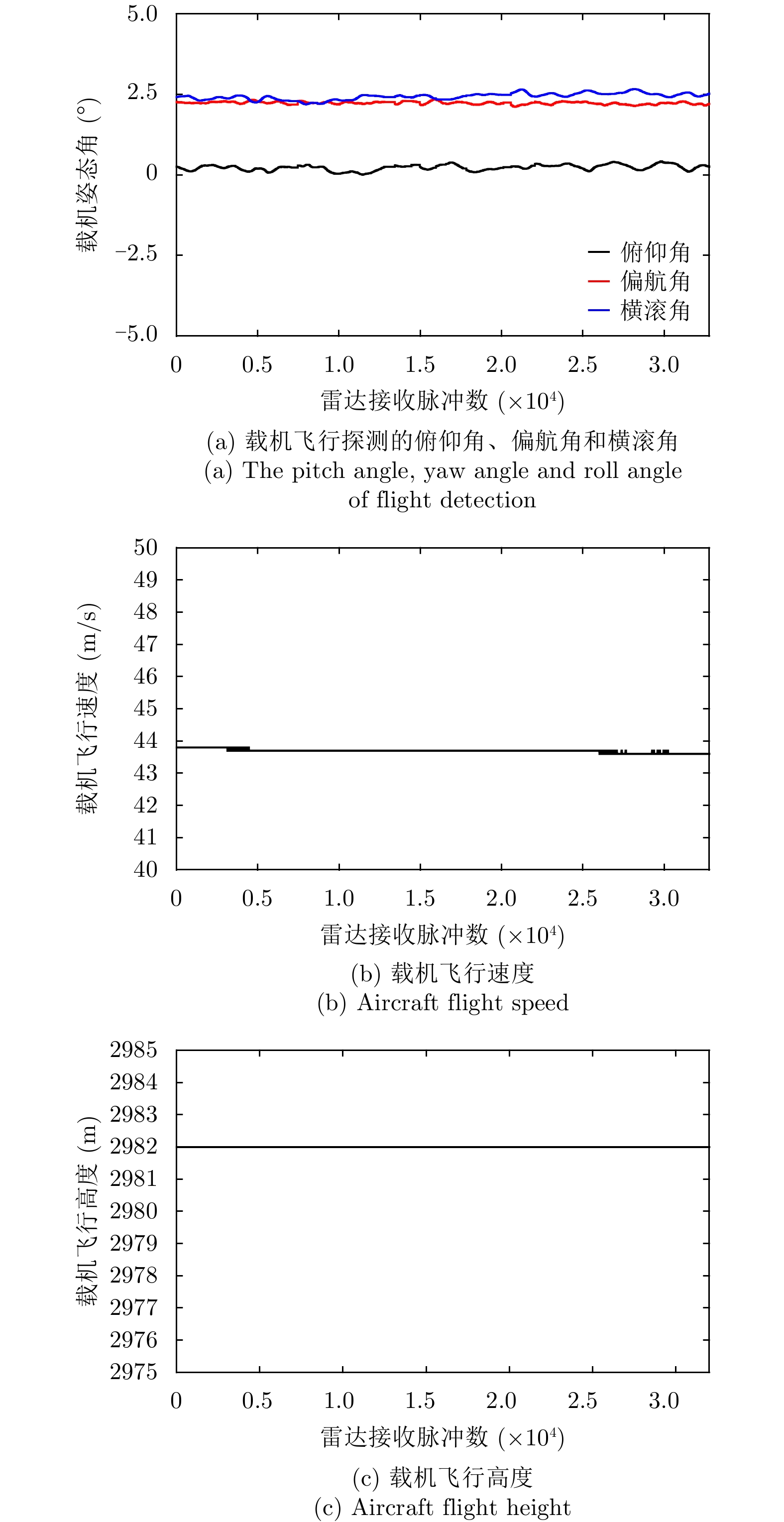
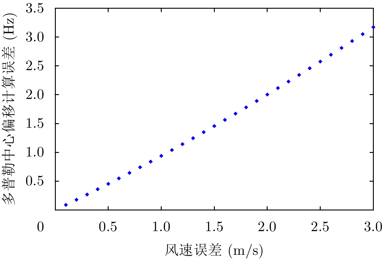
Doppler center shift is an important parameter for Synthetic Aperture Radar(SAR) to retrieve ocean surface wind field and ocean surface current field. We present a calculation method of Doppler centroid shift for airborne side-looking SAR. We compute Doppler centroid frequency by aircraft motion status data and ocean detection echo data respectively, and make difference to solve the Doppler centroid shift. In order to remove the influence of noise, we add wavelet analysis in Doppler spectrum analysis method to improve Doppler centroid frequency accuracy from ocean detection echo data. We carry out flight detection experiment by airborne SAR to obtain the Doppler centroid shift, while put buoy wind direction and wind speed in detection area into CDOP geophysical model function to simulate the Doppler centroid shift as compared to the validation true value. Flight detection results of 9 group data show that the calculation error absolute value of Doppler centroid shift are less than 2 Hz, and the RMS error is 1.4 Hz. It is meets the accuracy requirements of marine environmental factors retrieval, and proves the effective of Doppler centroid shift calculation method. In practical applications, the accuracy of Doppler centroid shift calculation is the key to the application of marine environment research, which requires high-precision platform motion data and sounding echo data to ensure application value.
Doppler center shift is an important parameter for Synthetic Aperture Radar(SAR) to retrieve ocean surface wind field and ocean surface current field. We present a calculation method of Doppler centroid shift for airborne side-looking SAR. We compute Doppler centroid frequency by aircraft motion status data and ocean detection echo data respectively, and make difference to solve the Doppler centroid shift. In order to remove the influence of noise, we add wavelet analysis in Doppler spectrum analysis method to improve Doppler centroid frequency accuracy from ocean detection echo data. We carry out flight detection experiment by airborne SAR to obtain the Doppler centroid shift, while put buoy wind direction and wind speed in detection area into CDOP geophysical model function to simulate the Doppler centroid shift as compared to the validation true value. Flight detection results of 9 group data show that the calculation error absolute value of Doppler centroid shift are less than 2 Hz, and the RMS error is 1.4 Hz. It is meets the accuracy requirements of marine environmental factors retrieval, and proves the effective of Doppler centroid shift calculation method. In practical applications, the accuracy of Doppler centroid shift calculation is the key to the application of marine environment research, which requires high-precision platform motion data and sounding echo data to ensure application value.


2019, 8(3): 400-412.
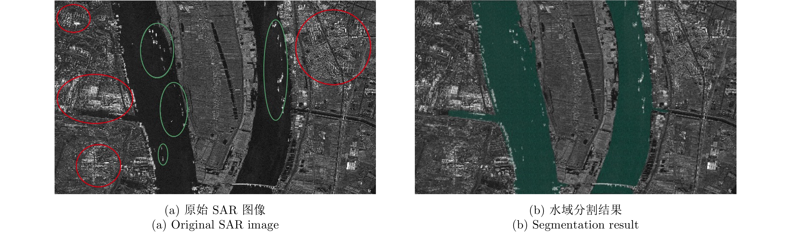
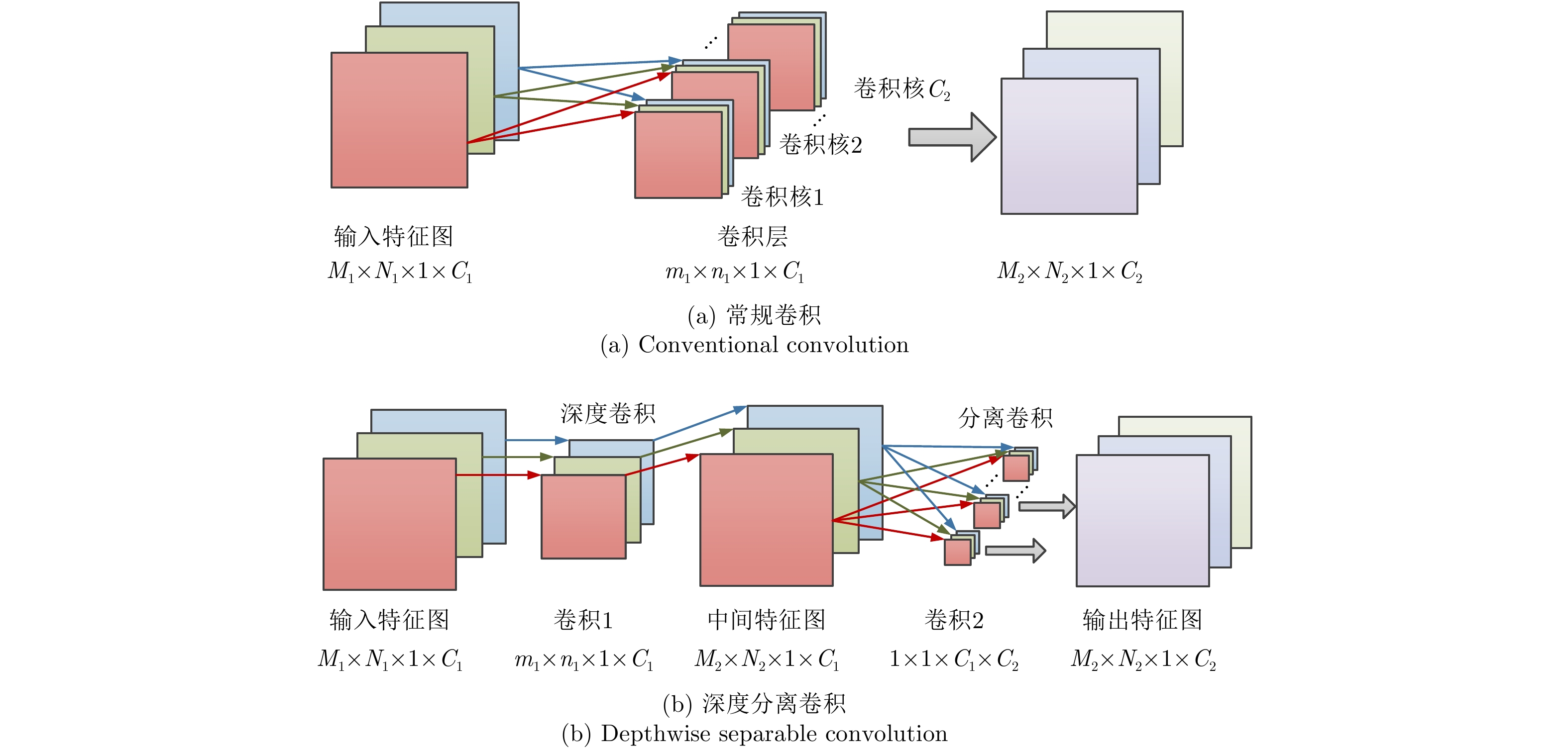
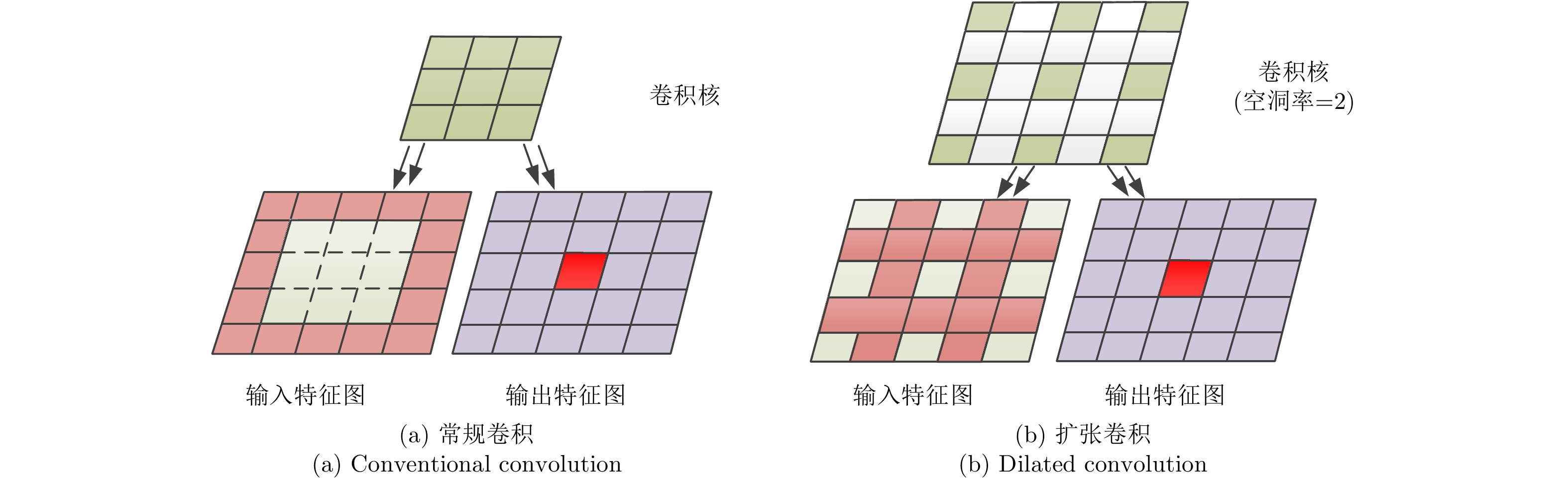
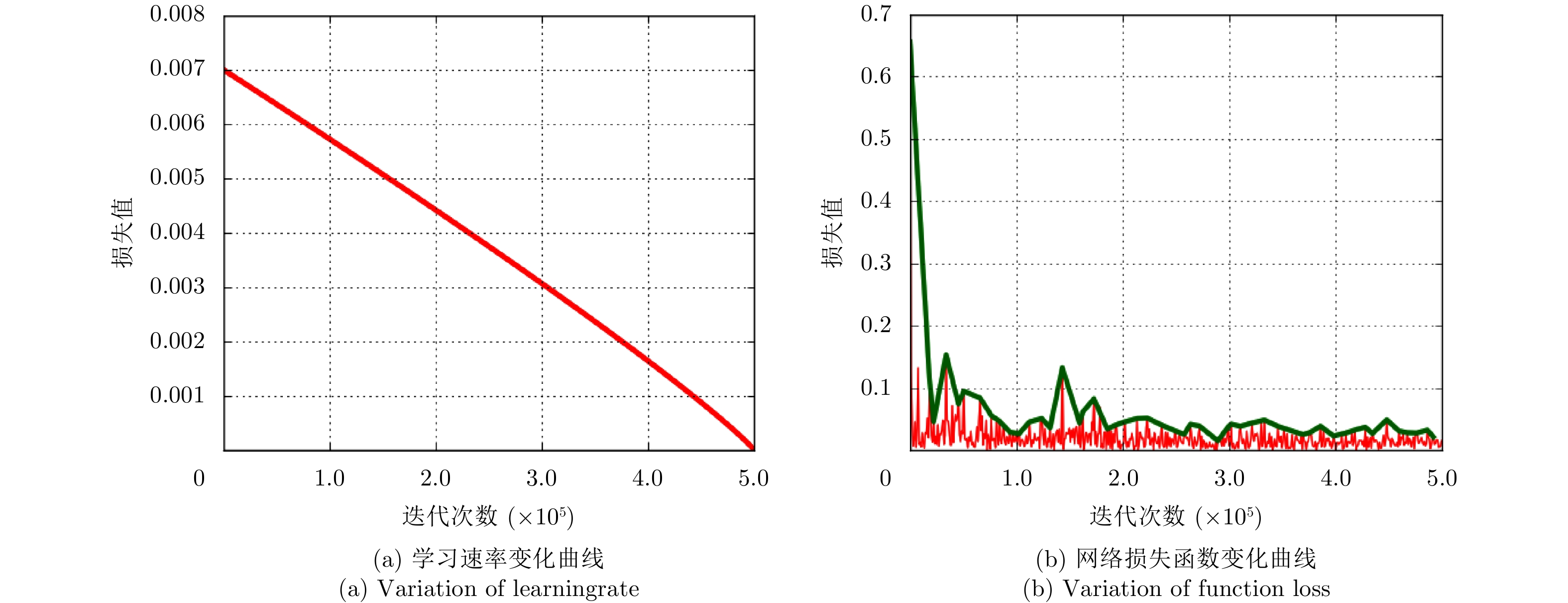
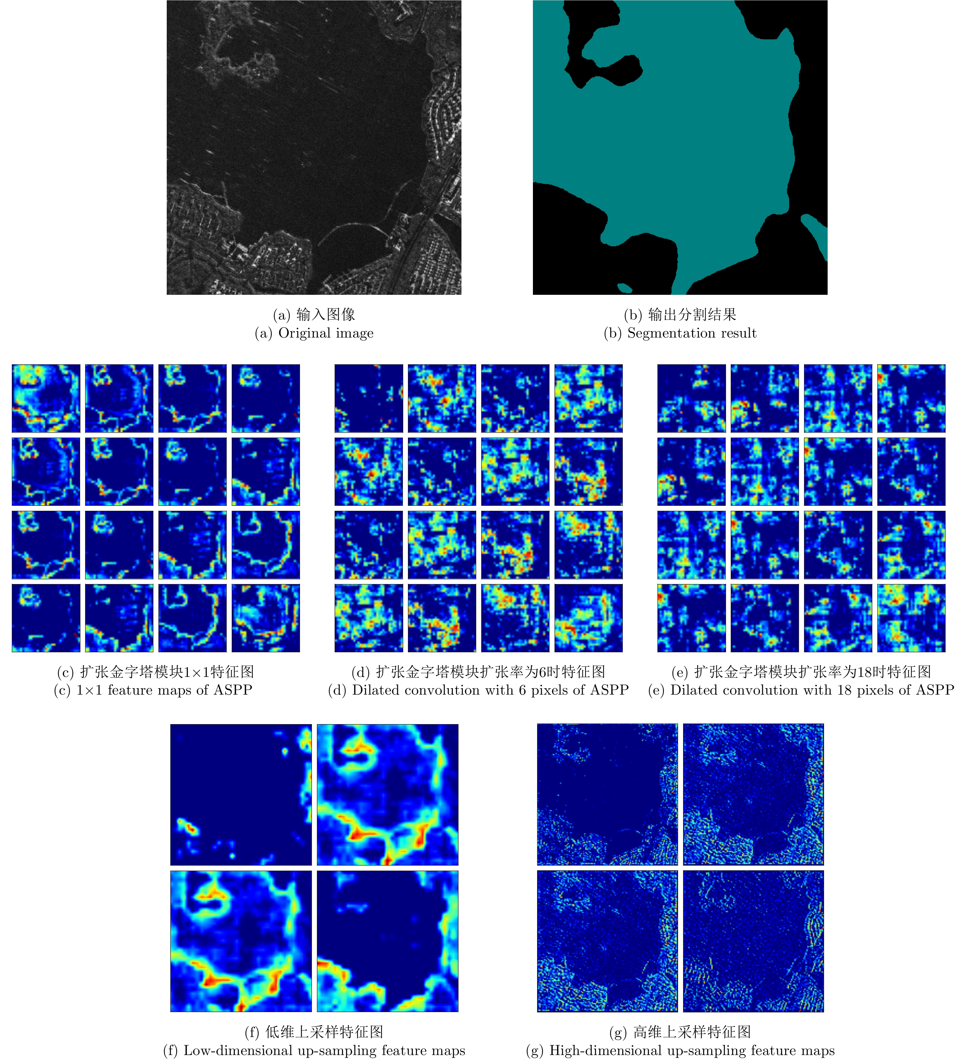
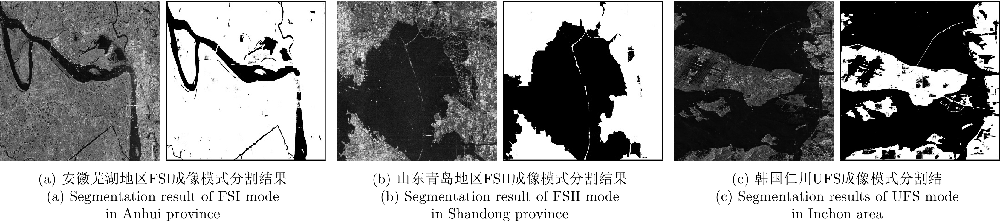
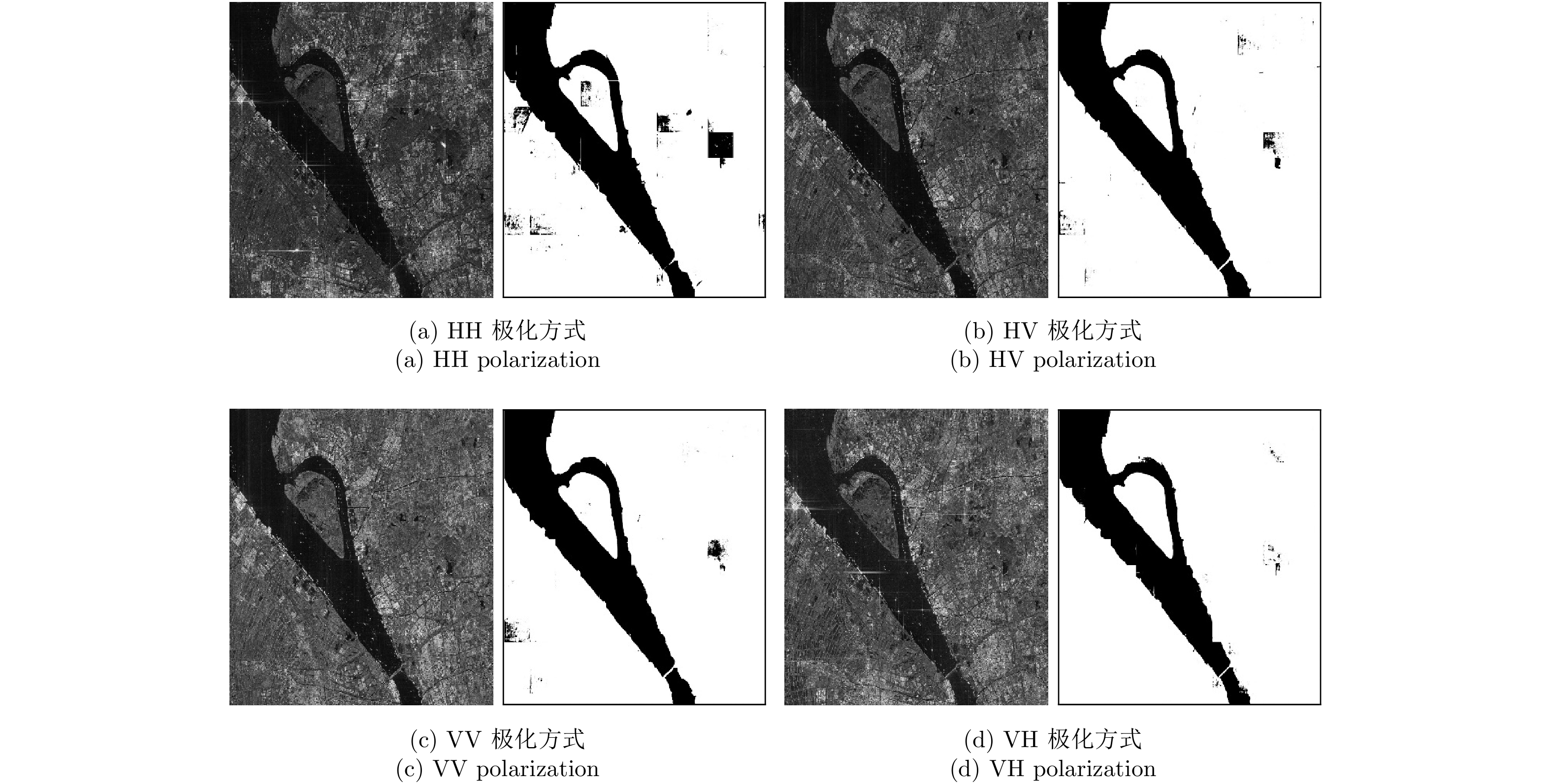
Water segmentation of real SAR images is of great significance in military and civilian applications such as ship target detection and disaster monitoring. To solve the issues of poor robustness and inaccurate segmentation of traditional water segmentation algorithms, this paper first establishes a SAR water segmentation dataset based on the GF3 satellite and then presents a segmentation network architecture based on depthwise separable convolution. The network takes real SAR images as inputs, extracts high-dimensional features through depthwise separable and dilated convolutions, constructs an up-sampling and decoding module based on bilinear interpolation, and then outputs the corresponding segmentation results. The segmentation results of a water segmentation dataset show that the proposed segmentation method remarkably improves the segmentation accuracy, the segmentation robustness and running speed than traditional method. Therefore, the findings demonstrate the excellent practical engineering value of the proposed algorithm.
Water segmentation of real SAR images is of great significance in military and civilian applications such as ship target detection and disaster monitoring. To solve the issues of poor robustness and inaccurate segmentation of traditional water segmentation algorithms, this paper first establishes a SAR water segmentation dataset based on the GF3 satellite and then presents a segmentation network architecture based on depthwise separable convolution. The network takes real SAR images as inputs, extracts high-dimensional features through depthwise separable and dilated convolutions, constructs an up-sampling and decoding module based on bilinear interpolation, and then outputs the corresponding segmentation results. The segmentation results of a water segmentation dataset show that the proposed segmentation method remarkably improves the segmentation accuracy, the segmentation robustness and running speed than traditional method. Therefore, the findings demonstrate the excellent practical engineering value of the proposed algorithm.


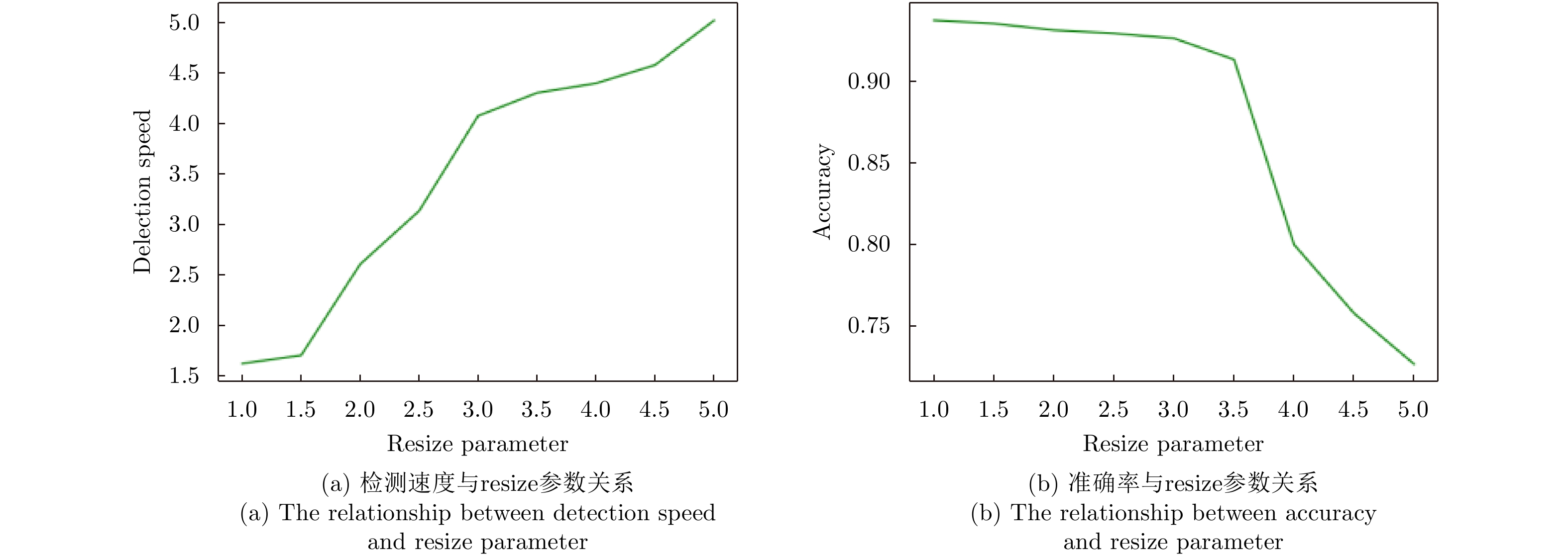
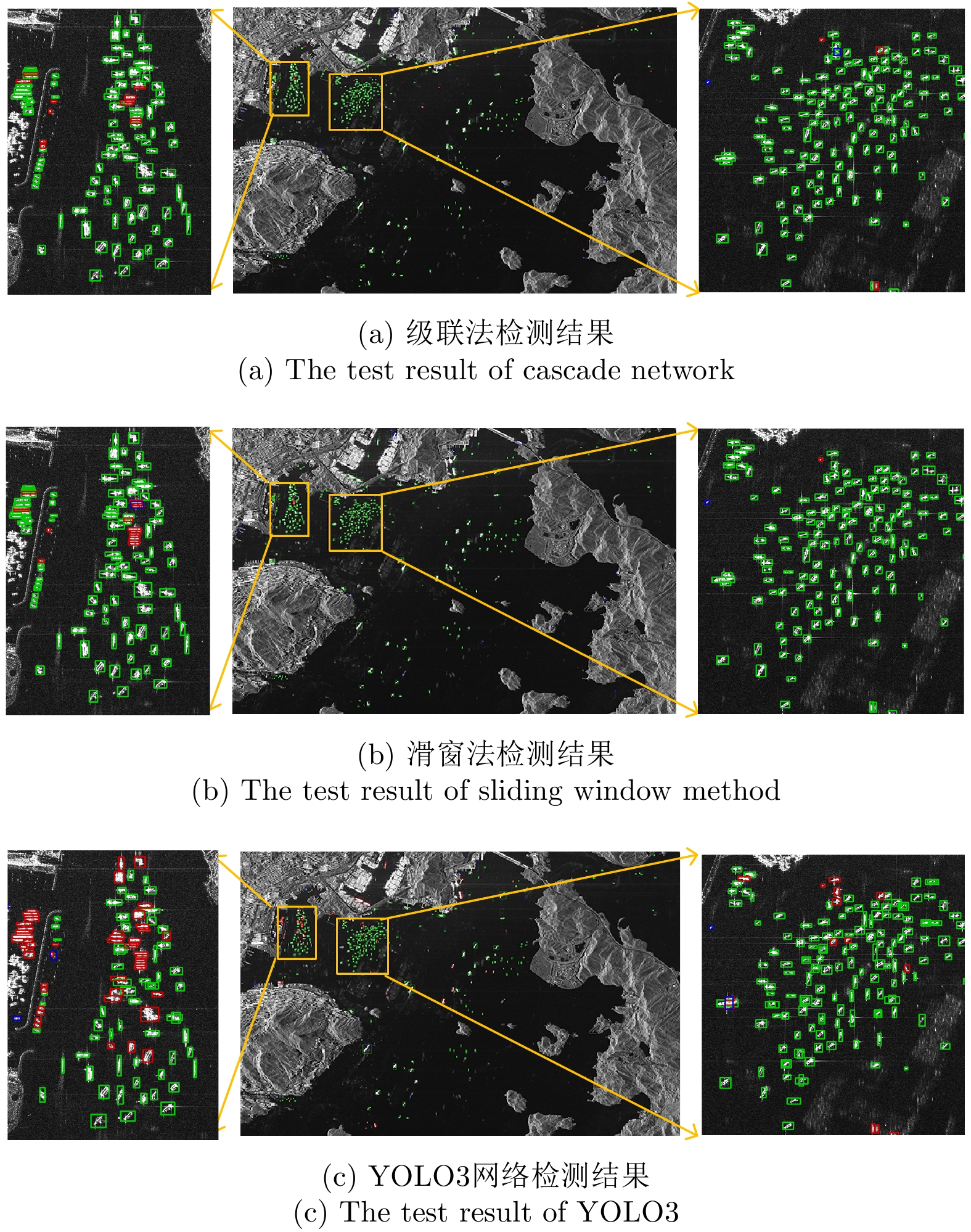
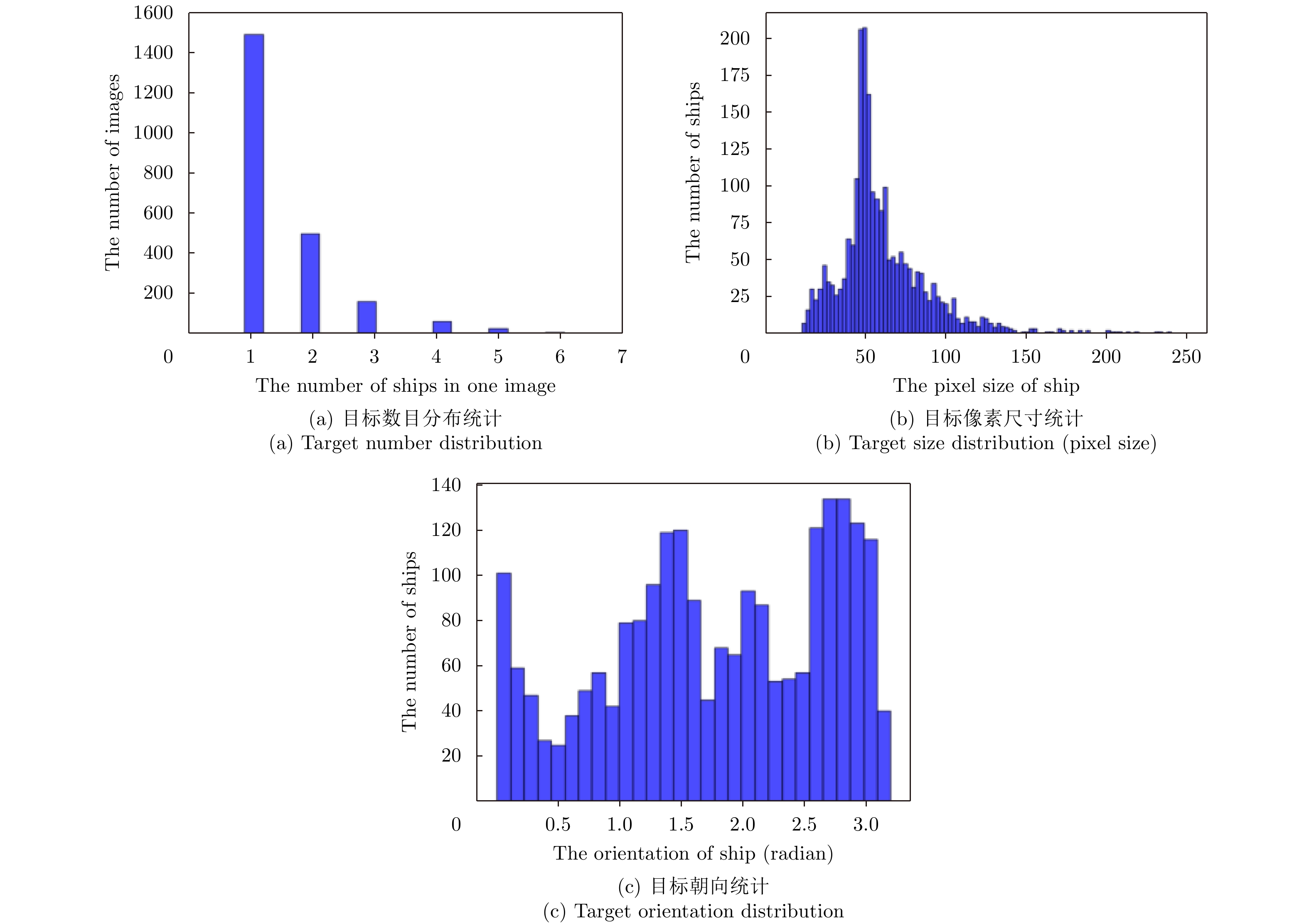
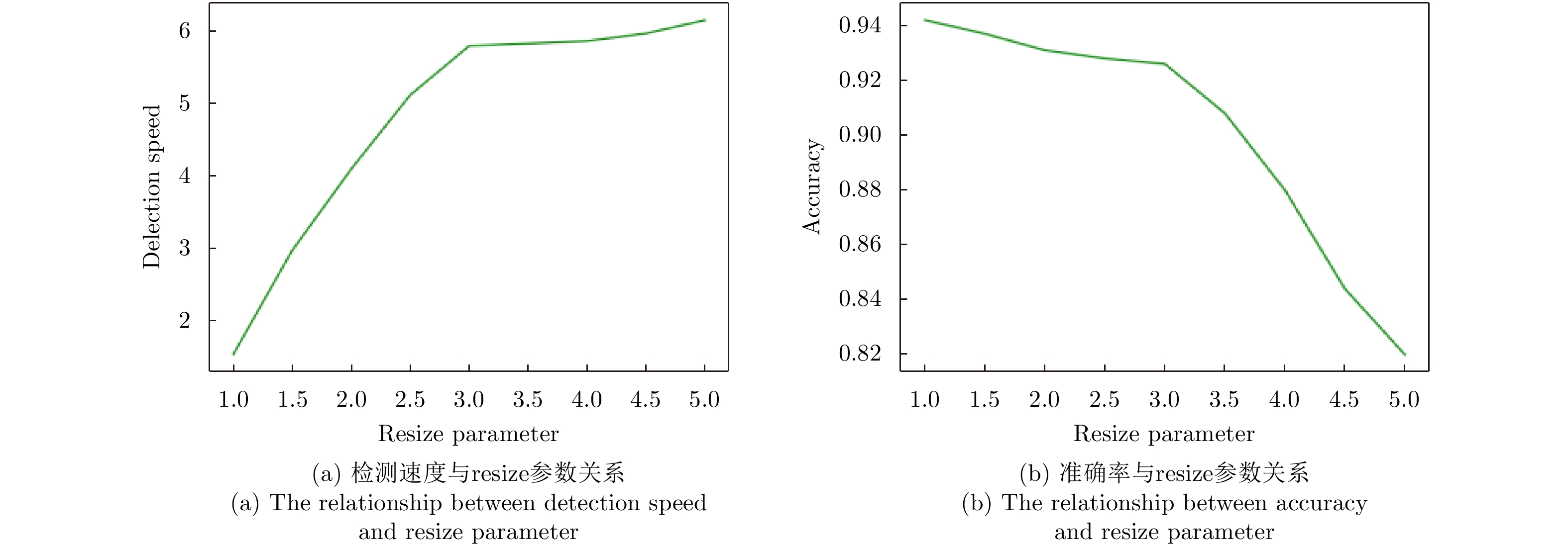
2019, 8(3): 413-424.
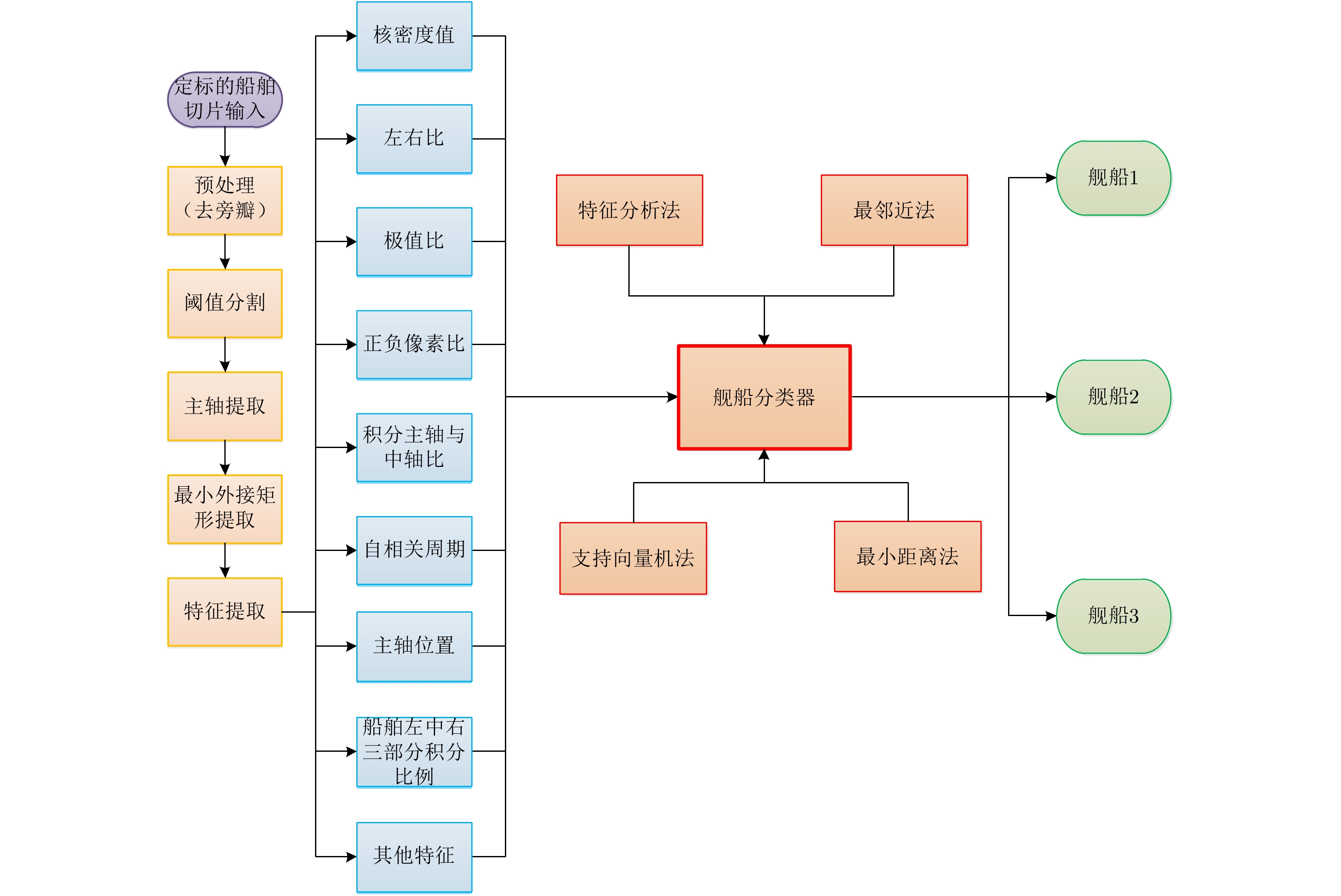
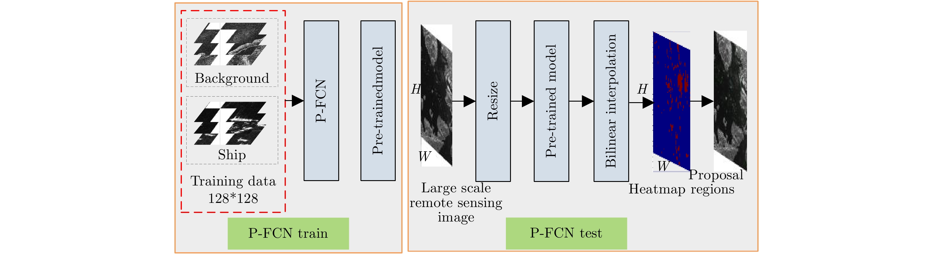
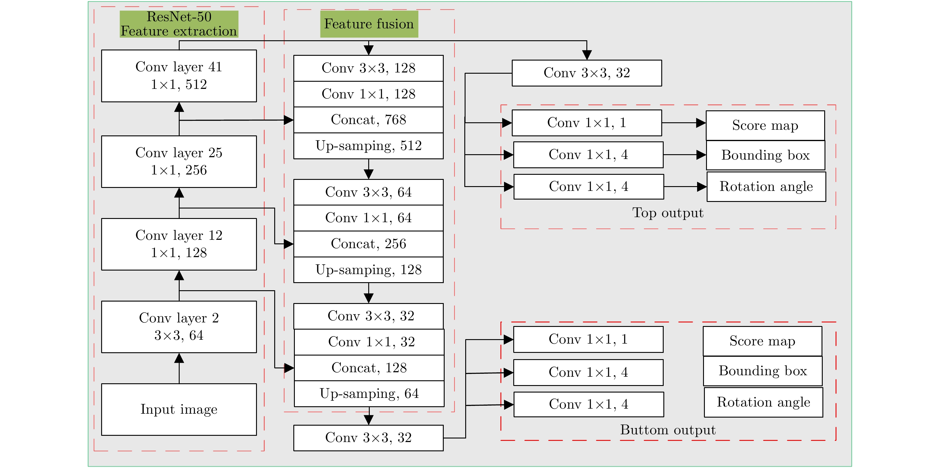
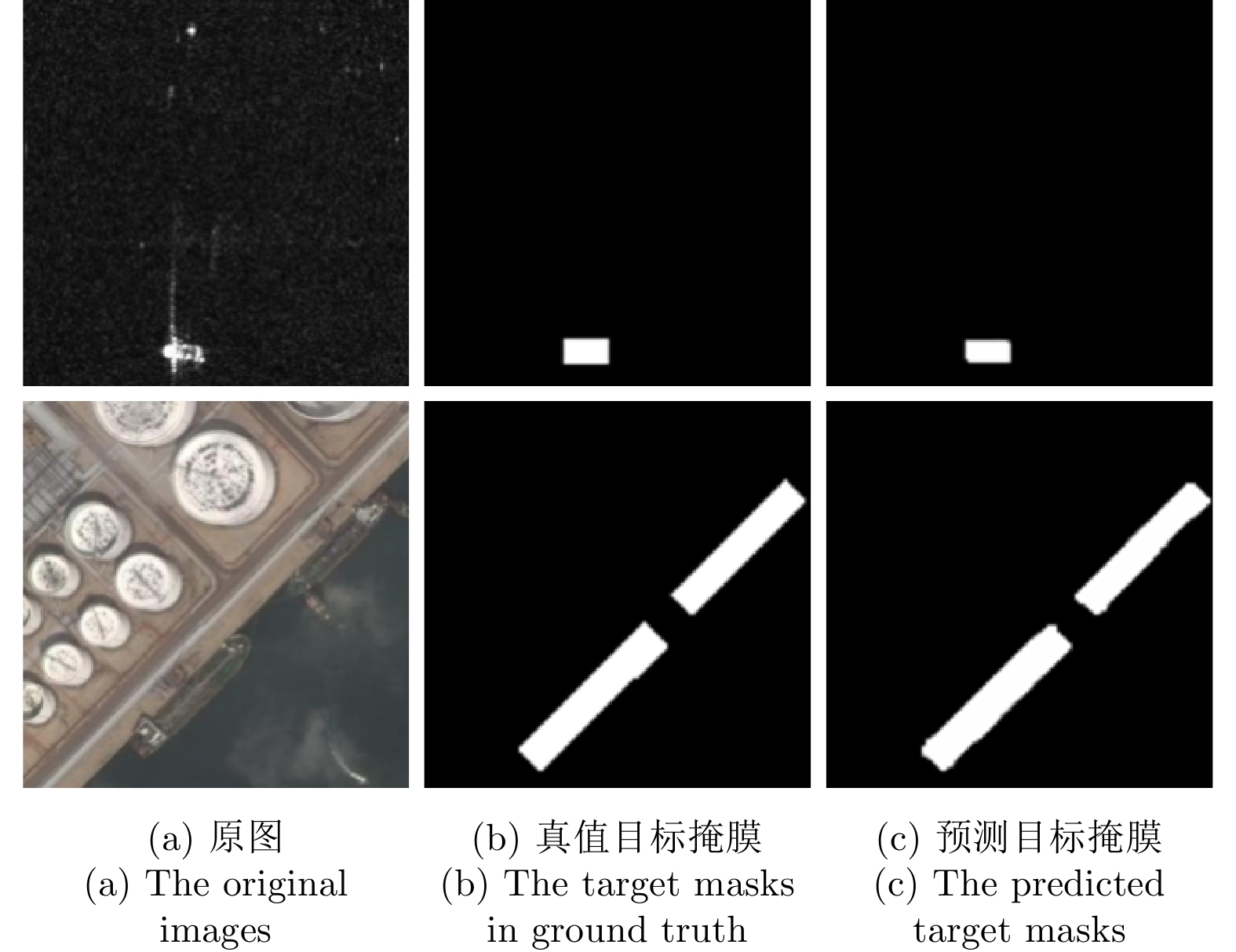
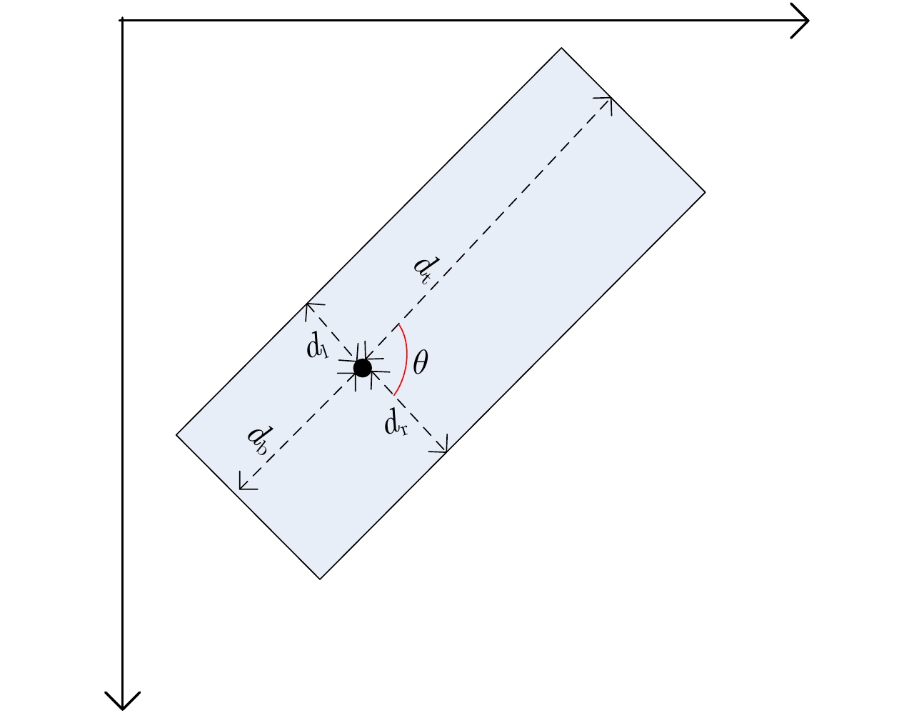
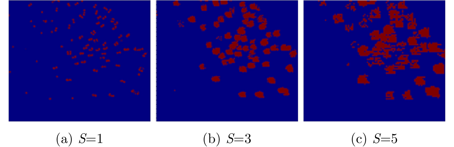
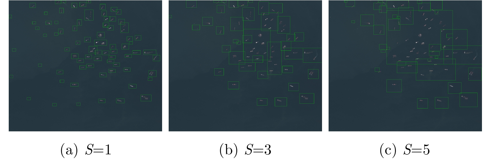
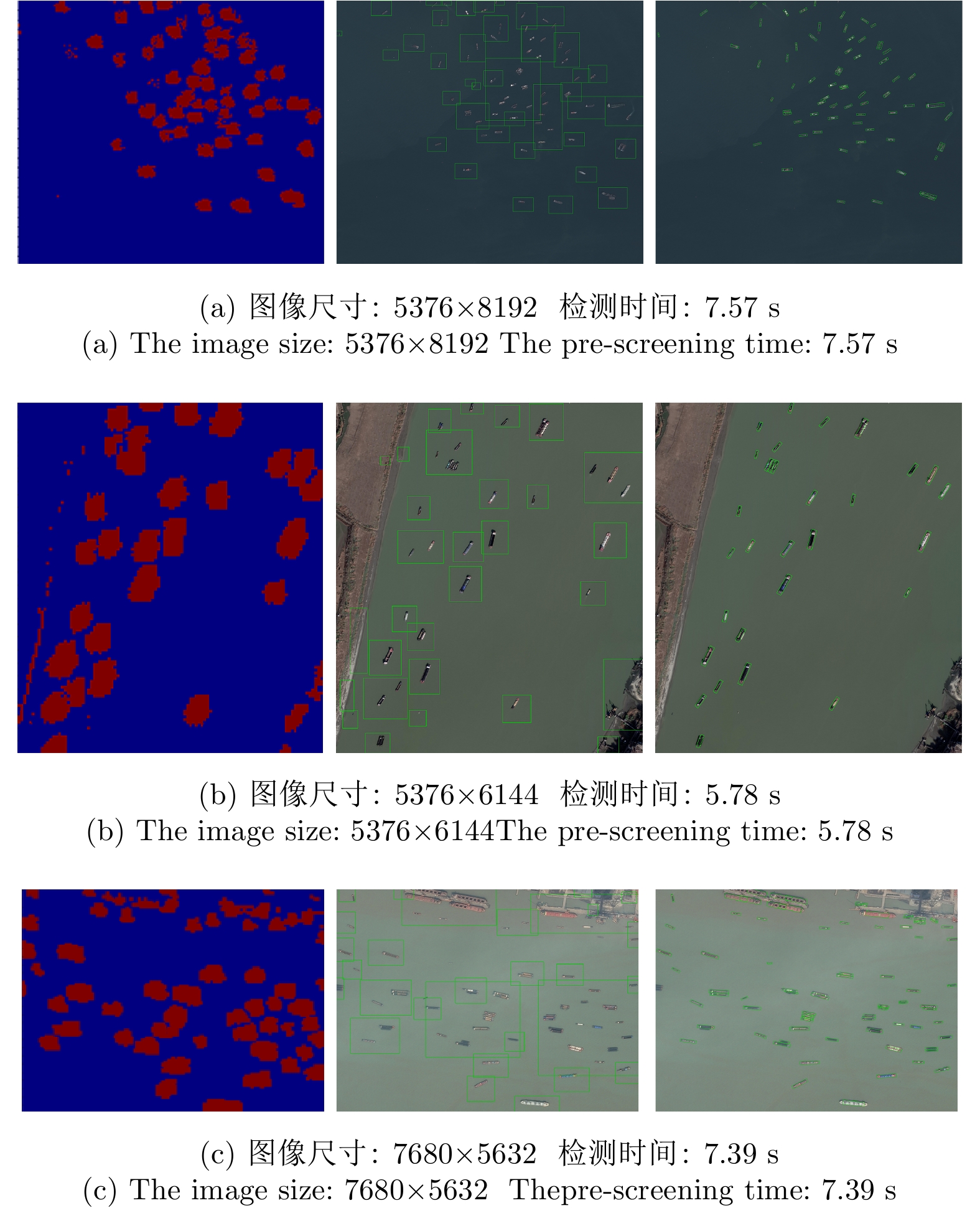
For the fast detection of ships in large-scale remote sensing images, a cascade convolutional neural network is proposed, which is a cascade combination of two Fully Convolutional Neural networks (FCNs), the target FCN for Prescreening (P-FCN), and the target FCN for Detection (D-FCN). The P-FCN is a lightweight image classification network that is responsible for the rapid pre-screening of possible ship areas in large-scale images. The region proposals generated by the P-FCN have less redundancy, which can reduce the computational burden of the D-FCN. The D-FCN is an improved U-Net that can accurately detect arbitrary-oriented ships by adding target masks and ship orientation estimation layers to the traditional U-Net structure for multitask learning. In our experiment, TerraSAR-X remote sensing images and the optical remote sensing images obtained from the 91 satellite map software and the DOTA dataset were used to test the network. The results show that the detection accuracy of our method was 0.928 and 0.926 for synthetic aperture radar images and optical images, respectively, which were close to the performance of the traditional sliding window method. However, the running time of the proposed method was only about 1/3 of that of the sliding window method. Therefore, the cascade convolutional neural network can significantly improve the target detection efficiency while maintaining the detection accuracy and can realize the rapid detection of ship targets in large-scale remote sensing images.
For the fast detection of ships in large-scale remote sensing images, a cascade convolutional neural network is proposed, which is a cascade combination of two Fully Convolutional Neural networks (FCNs), the target FCN for Prescreening (P-FCN), and the target FCN for Detection (D-FCN). The P-FCN is a lightweight image classification network that is responsible for the rapid pre-screening of possible ship areas in large-scale images. The region proposals generated by the P-FCN have less redundancy, which can reduce the computational burden of the D-FCN. The D-FCN is an improved U-Net that can accurately detect arbitrary-oriented ships by adding target masks and ship orientation estimation layers to the traditional U-Net structure for multitask learning. In our experiment, TerraSAR-X remote sensing images and the optical remote sensing images obtained from the 91 satellite map software and the DOTA dataset were used to test the network. The results show that the detection accuracy of our method was 0.928 and 0.926 for synthetic aperture radar images and optical images, respectively, which were close to the performance of the traditional sliding window method. However, the running time of the proposed method was only about 1/3 of that of the sliding window method. Therefore, the cascade convolutional neural network can significantly improve the target detection efficiency while maintaining the detection accuracy and can realize the rapid detection of ship targets in large-scale remote sensing images.


 微信 | 公众平台

