
 Submit Manuscript
 Peer Review
 Editor Work
2018 Vol. 7, No. 6
 Previous Issue
2018, 7(6): 633-654.
 Abstract
 4515KB
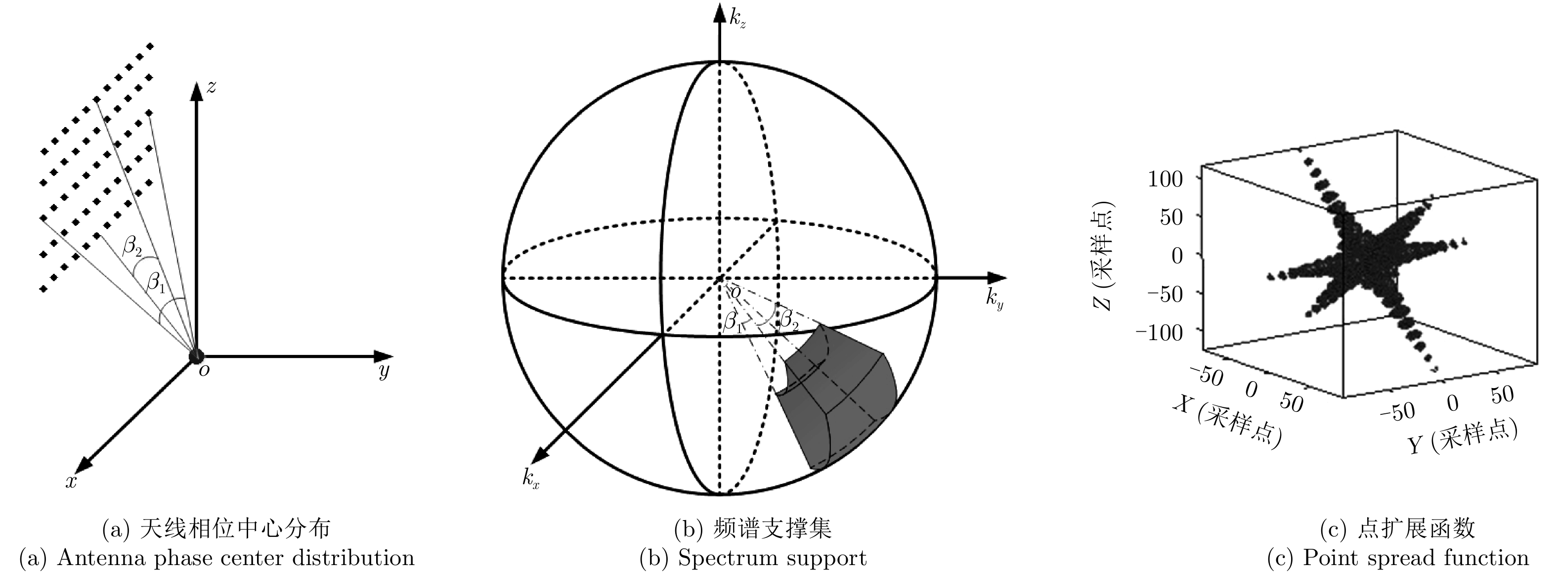
Conventional Synthetic Aperture Radar (SAR) moves along a straight line and forms a linear synthetic apertures. It can only obtain the two-dimensional (2-D) image of illuminated scene that is the projection of the three-dimensional (3-D) real scene onto a slant plane. The slant plane 2-D SAR image, however, suffers from layover and foreshortening effects. 3-D SAR imaging enables 3-D resolving capability by extending the acquisition of frequency information from 2-D to 3-D. It can obtain the 3-D distribution of scattering centers; therefore, it solves the geometric deformation problems of layover and foreshortening. 3-D SAR imaging has become a trending topic in research on SAR techniques worldwide. In this paper, we first introduced the concept of 3-D SAR imaging and several typical 3-D SAR imaging modes. Furthermore, it provides a discussion on research progress at home and abroad, particularly focusing on the progress of our research team. Finally, future research prospects are presented.
Conventional Synthetic Aperture Radar (SAR) moves along a straight line and forms a linear synthetic apertures. It can only obtain the two-dimensional (2-D) image of illuminated scene that is the projection of the three-dimensional (3-D) real scene onto a slant plane. The slant plane 2-D SAR image, however, suffers from layover and foreshortening effects. 3-D SAR imaging enables 3-D resolving capability by extending the acquisition of frequency information from 2-D to 3-D. It can obtain the 3-D distribution of scattering centers; therefore, it solves the geometric deformation problems of layover and foreshortening. 3-D SAR imaging has become a trending topic in research on SAR techniques worldwide. In this paper, we first introduced the concept of 3-D SAR imaging and several typical 3-D SAR imaging modes. Furthermore, it provides a discussion on research progress at home and abroad, particularly focusing on the progress of our research team. Finally, future research prospects are presented.


2018, 7(6): 655-663.
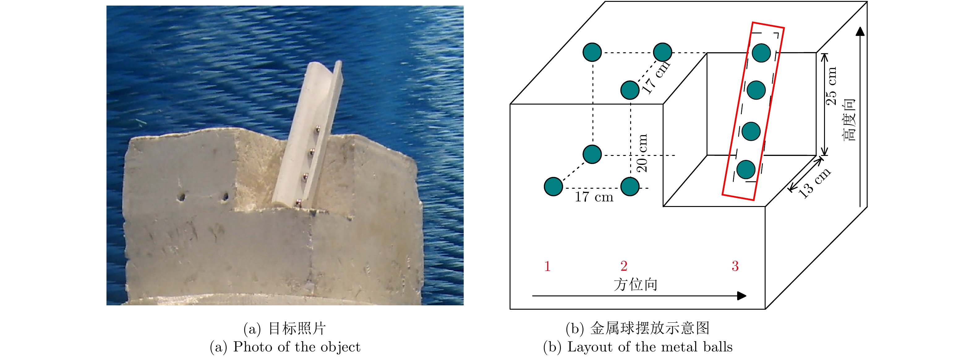
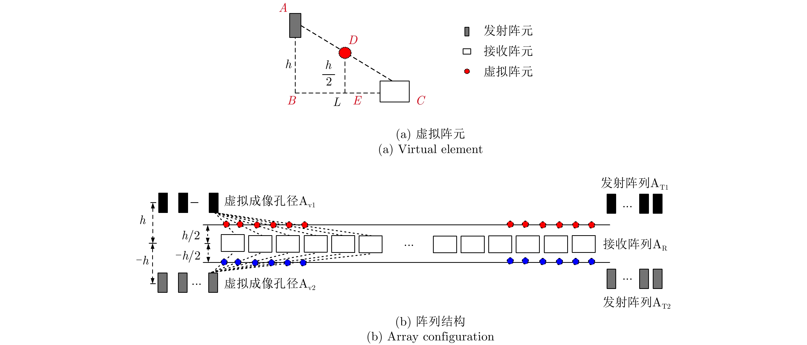
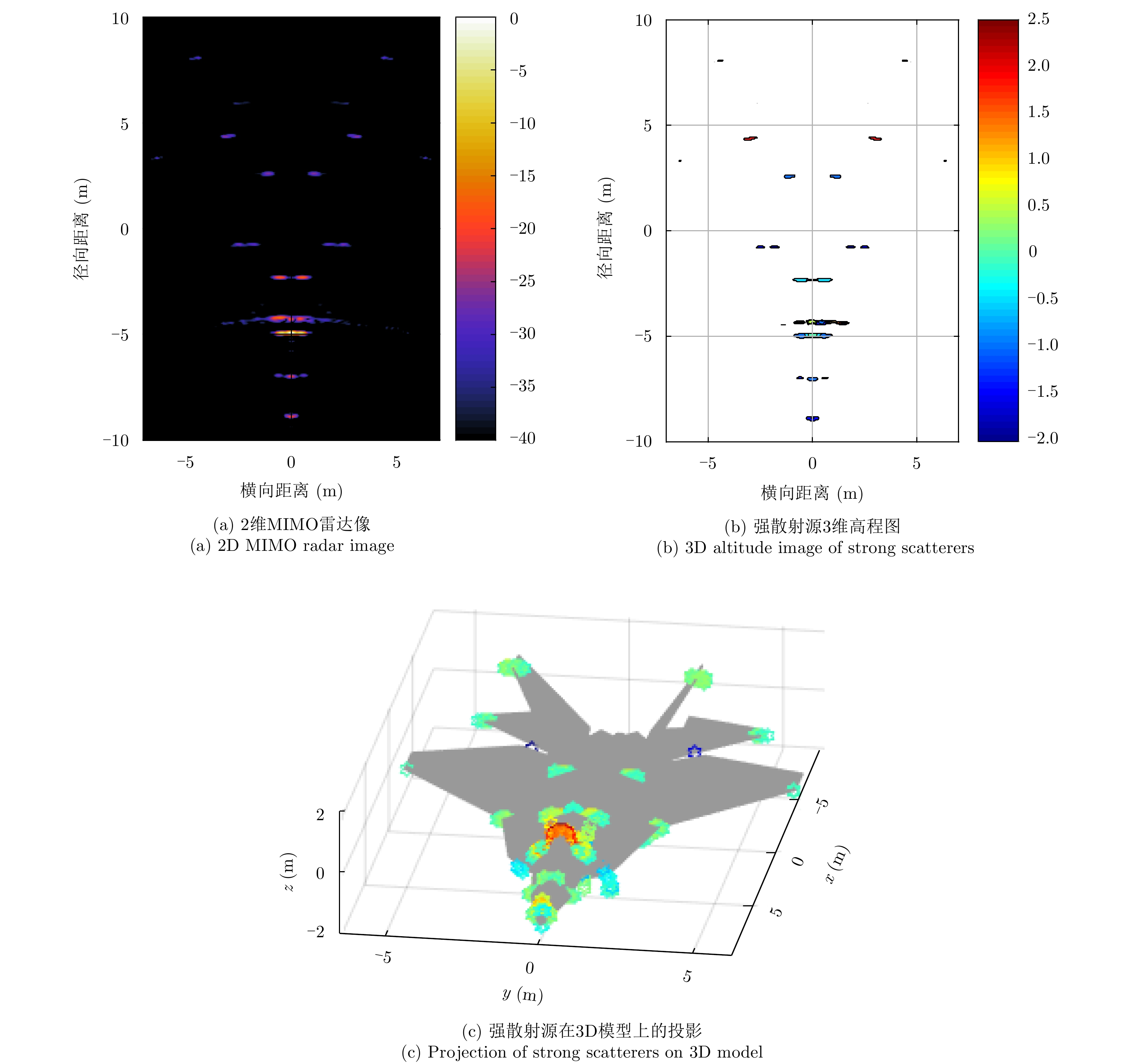
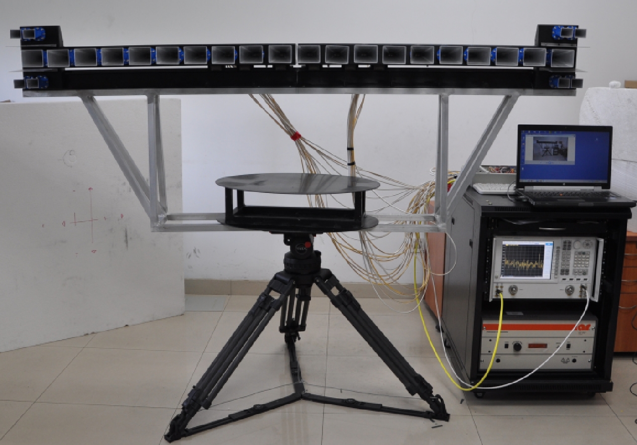
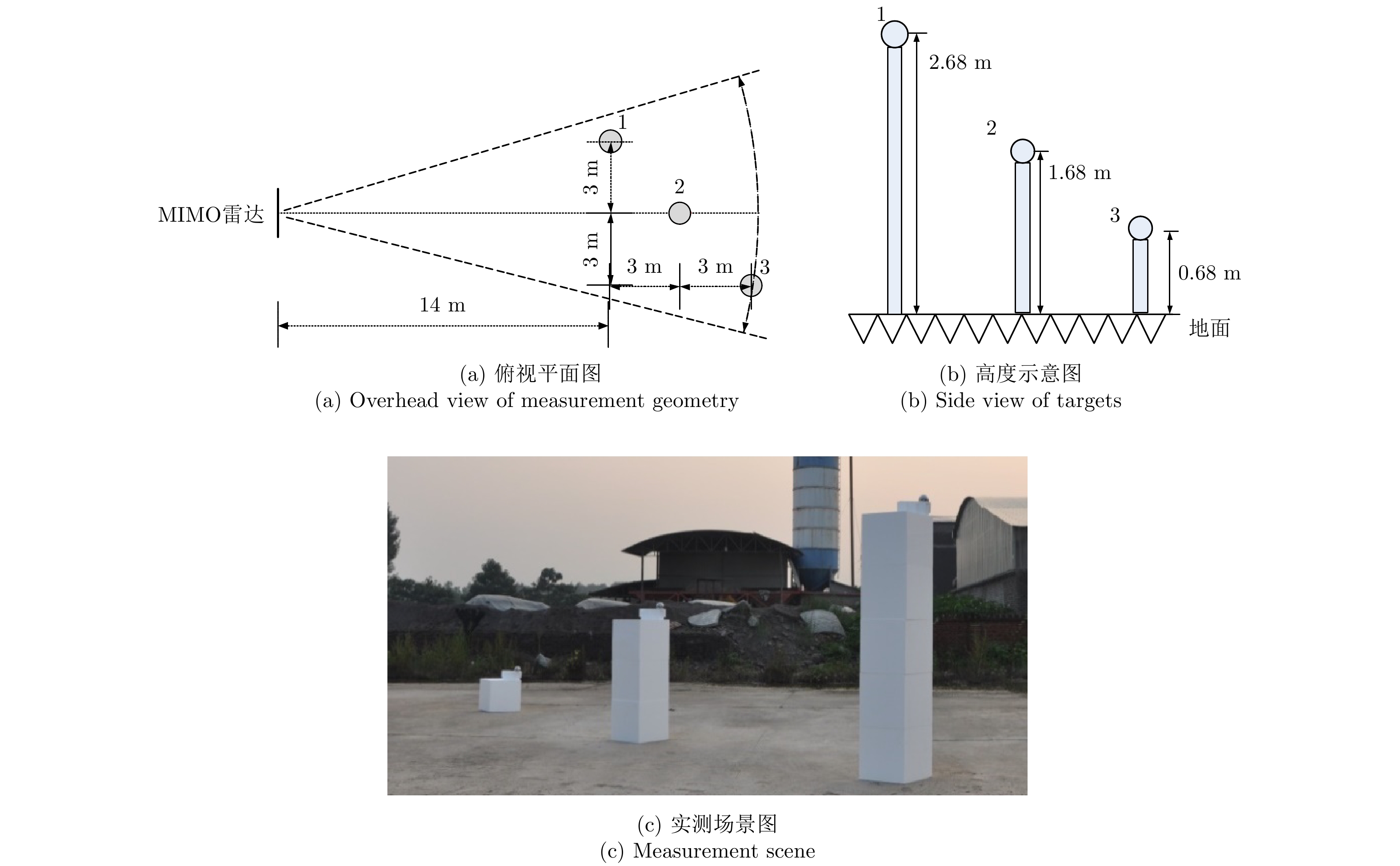
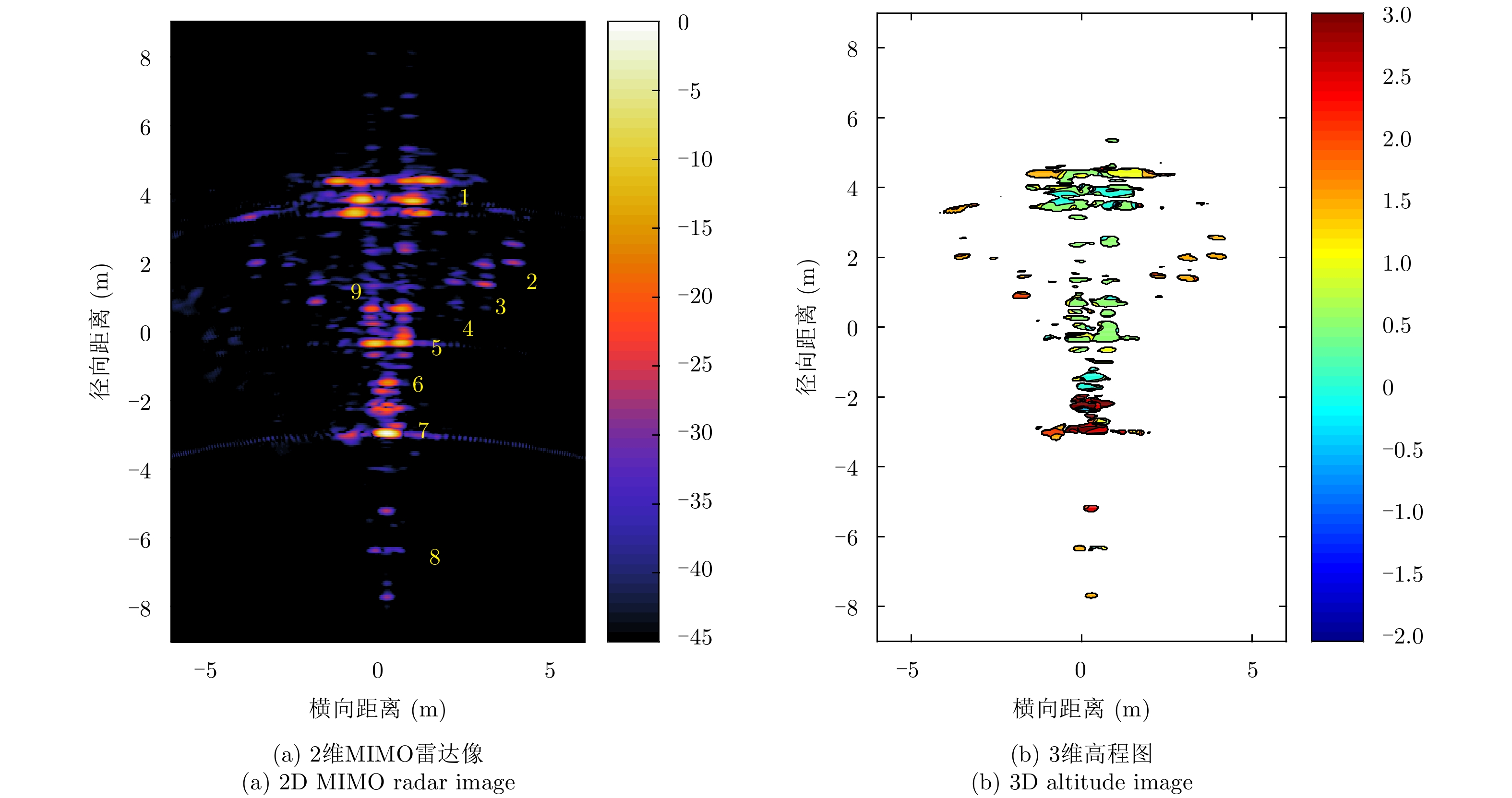
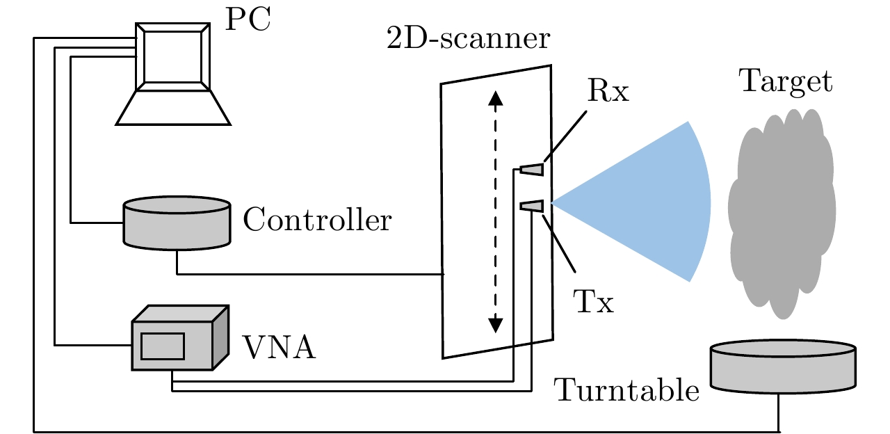
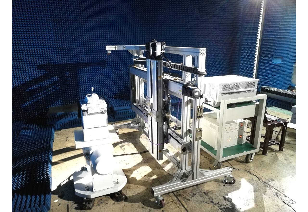
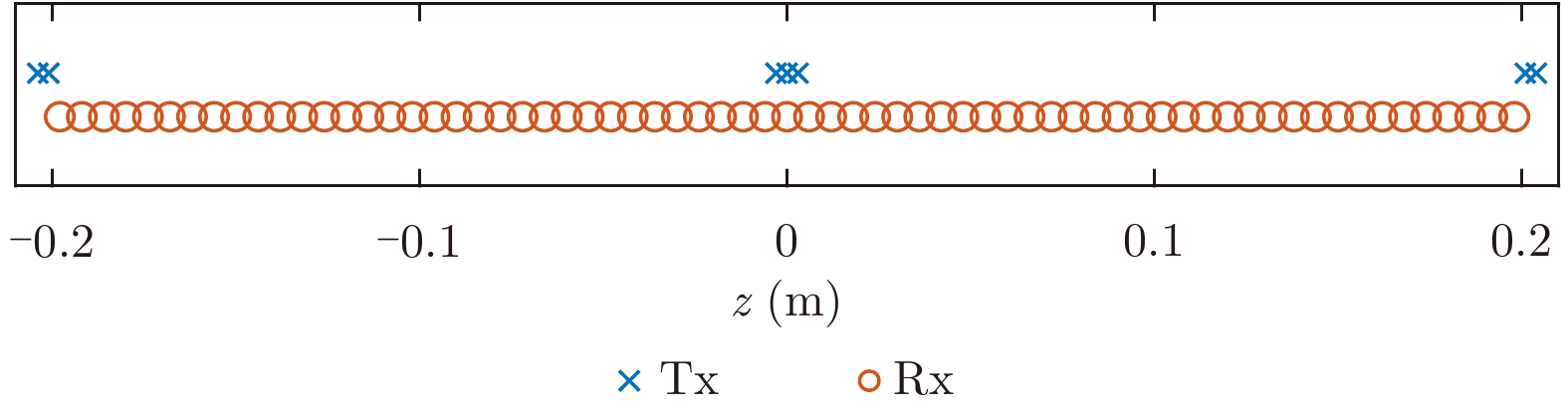
Two-dimensional (2D) Synthetic Aperture Radar (SAR) and Inverse SAR (ISAR) imaging is of importance for diagnostic studies of target scattering mechanisms. Rail SAR and turntable ISAR are currently widely applied techniques for high resolution diagnostic imaging of complex targets. Three-dimensional (3D) imagery has the advantage of providing scattering magnitude and exact positions in altitude and in down-range and cross-range for each scattering center on a complex target. Thus, development of various 3D imaging radar systems for diagnostic measurements is attracting increasing attention from radar researchers. In this work, a novel 3D imaging method based on Multiple-Input Multiple-Output (MIMO) radar and interferometric SAR processing is proposed. First, a MIMO array capable of interferometric measurement with high aperture utilization ratio is designed and tested. Then, a signal model for interferometric MIMO radar is formulated. The relation between interferometric phase and scatterer altitude is specifically analyzed, and a 3D image formation algorithm is developed. Finally, a numerical simulation and field data acquired using experimental MIMO radar system are presented to demonstrate the feasibility and usefulness of the proposed method for target scattering diagnosis. The proposed method has more advantages than current 3D imaging techniques, such as high measurement efficiency, low research and development cost, and strong environmental adaptability.
Two-dimensional (2D) Synthetic Aperture Radar (SAR) and Inverse SAR (ISAR) imaging is of importance for diagnostic studies of target scattering mechanisms. Rail SAR and turntable ISAR are currently widely applied techniques for high resolution diagnostic imaging of complex targets. Three-dimensional (3D) imagery has the advantage of providing scattering magnitude and exact positions in altitude and in down-range and cross-range for each scattering center on a complex target. Thus, development of various 3D imaging radar systems for diagnostic measurements is attracting increasing attention from radar researchers. In this work, a novel 3D imaging method based on Multiple-Input Multiple-Output (MIMO) radar and interferometric SAR processing is proposed. First, a MIMO array capable of interferometric measurement with high aperture utilization ratio is designed and tested. Then, a signal model for interferometric MIMO radar is formulated. The relation between interferometric phase and scatterer altitude is specifically analyzed, and a 3D image formation algorithm is developed. Finally, a numerical simulation and field data acquired using experimental MIMO radar system are presented to demonstrate the feasibility and usefulness of the proposed method for target scattering diagnosis. The proposed method has more advantages than current 3D imaging techniques, such as high measurement efficiency, low research and development cost, and strong environmental adaptability.


2018, 7(6): 664-675.
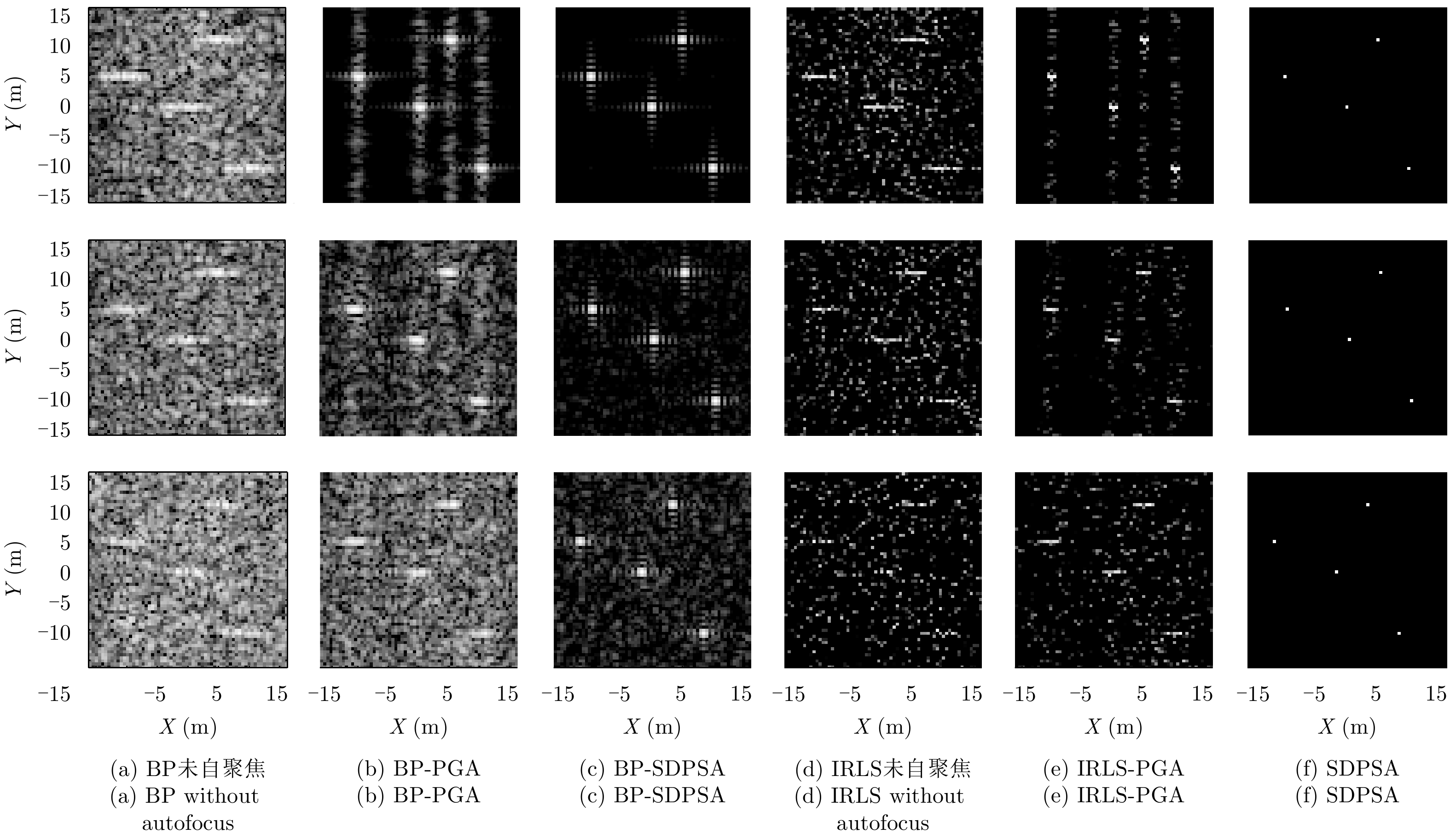
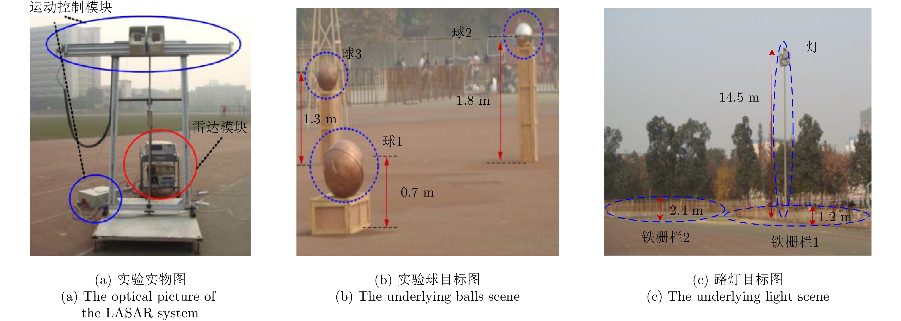
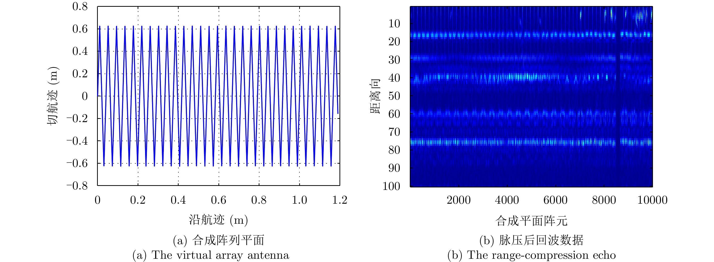
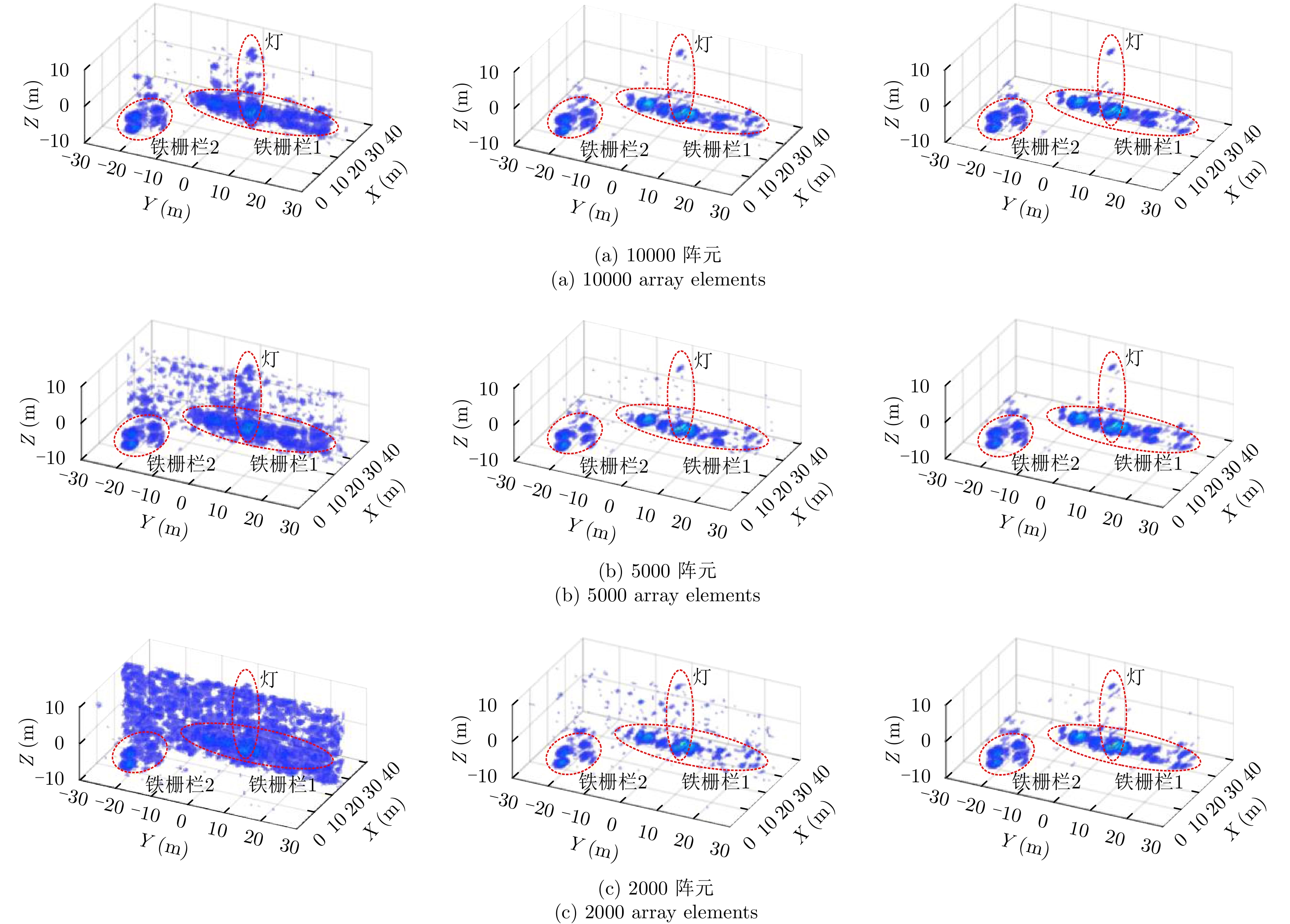
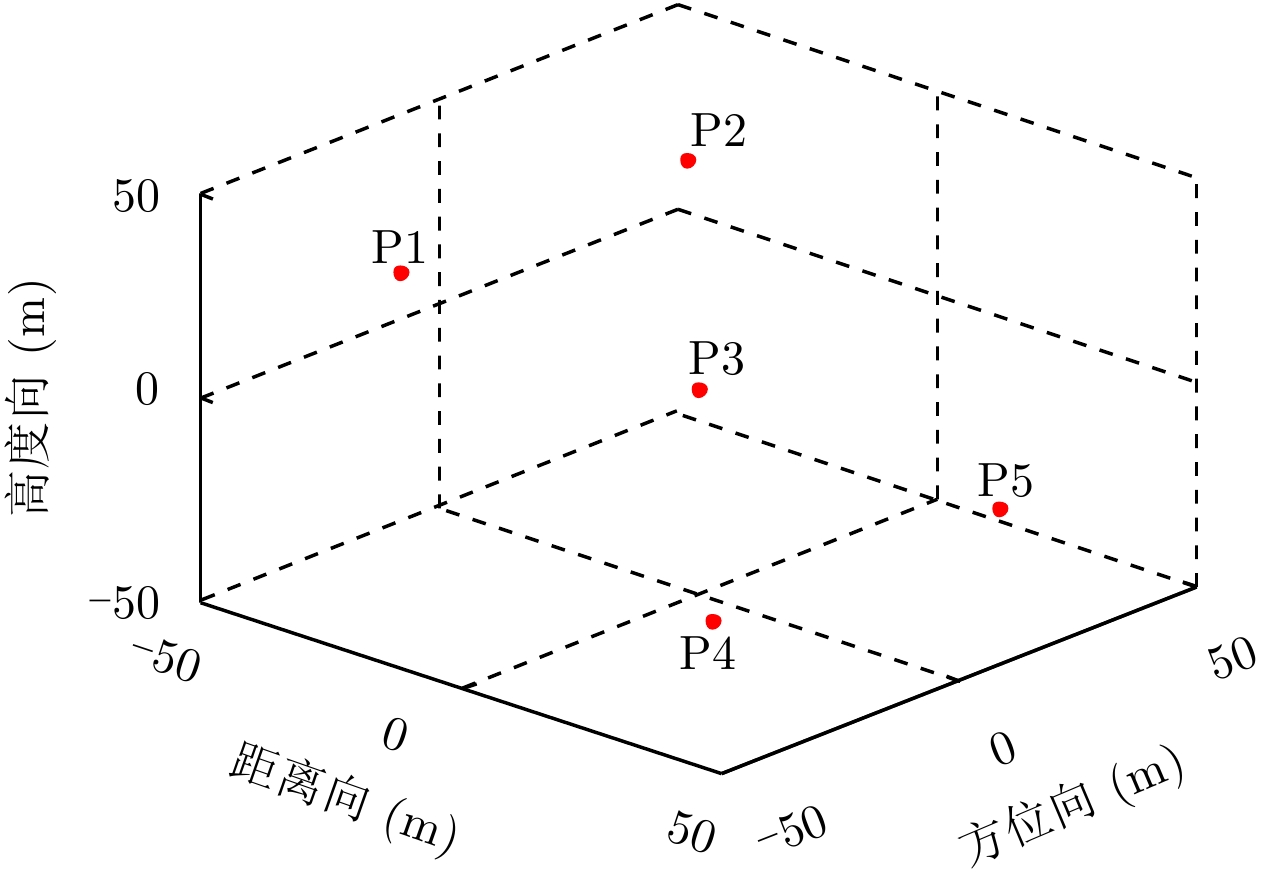
Linear Array Synthetic Aperture Radar (LASAR) is a novel and promising radar imaging technique. In recent years, Compressed Sensing (CS) sparse recovery has been a research focus for high-resolution three-Dimensional (3-D) LASAR imaging. Compared with the traditional two-Dimensional (2-D) SAR imaging, LASAR suffers from many problems, including under-sampling data and multi-dimensional and higher-order phase errors due to its sparse Linear Array Antenna (LAA) and the joint 2-D motions of the platform and LAA. The conventional autofocusing methods of 2-D SAR may be not suitable for CS-based LASAR 3-D sparse autofocusing. To address the multi-dimensional and higher-order phase errors in LASAR 3-D imaging with respect to under-sampling data, in this paper, we propose a sparse autofocusing algorithm based on semi-definite programming for CS-based LASAR imaging. First, by combining CS-based imaging theory, image maximum sharpness, and the minimum square error principle, we construct a LASAR phase-error estimation model based on under-sampled data. Next, we use semi-definite programming relaxation to estimate the phase errors. Lastly, we employ an iterated approximation method to improve the precision of the phase-error estimation and achieve the final CS-based LASAR autofocusing. To further improve the efficiency of the algorithm, we select only the dominant scattering areas for LASAR phase-error estimation. We present our simulation and experimental results to confirm the effectiveness of out proposed algorithm.
Linear Array Synthetic Aperture Radar (LASAR) is a novel and promising radar imaging technique. In recent years, Compressed Sensing (CS) sparse recovery has been a research focus for high-resolution three-Dimensional (3-D) LASAR imaging. Compared with the traditional two-Dimensional (2-D) SAR imaging, LASAR suffers from many problems, including under-sampling data and multi-dimensional and higher-order phase errors due to its sparse Linear Array Antenna (LAA) and the joint 2-D motions of the platform and LAA. The conventional autofocusing methods of 2-D SAR may be not suitable for CS-based LASAR 3-D sparse autofocusing. To address the multi-dimensional and higher-order phase errors in LASAR 3-D imaging with respect to under-sampling data, in this paper, we propose a sparse autofocusing algorithm based on semi-definite programming for CS-based LASAR imaging. First, by combining CS-based imaging theory, image maximum sharpness, and the minimum square error principle, we construct a LASAR phase-error estimation model based on under-sampled data. Next, we use semi-definite programming relaxation to estimate the phase errors. Lastly, we employ an iterated approximation method to improve the precision of the phase-error estimation and achieve the final CS-based LASAR autofocusing. To further improve the efficiency of the algorithm, we select only the dominant scattering areas for LASAR phase-error estimation. We present our simulation and experimental results to confirm the effectiveness of out proposed algorithm.


2018, 7(6): 676-684.
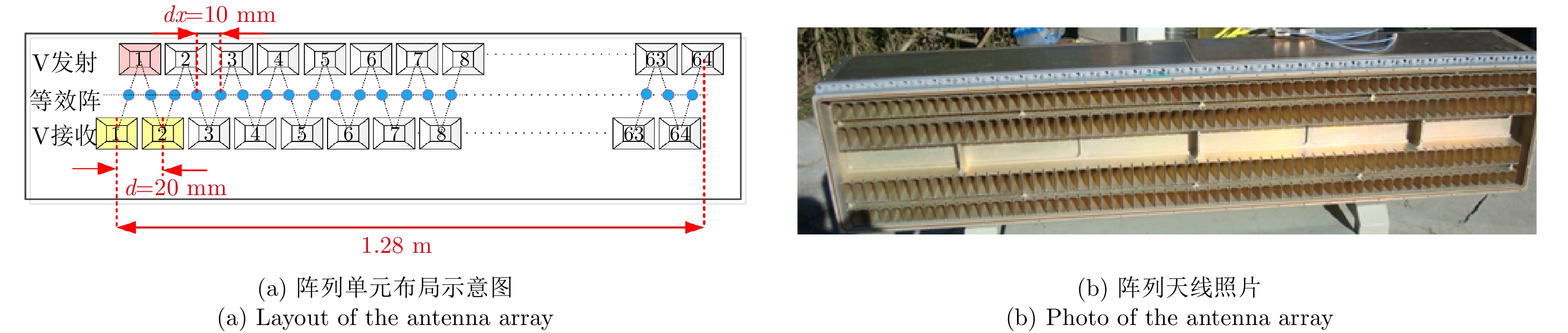
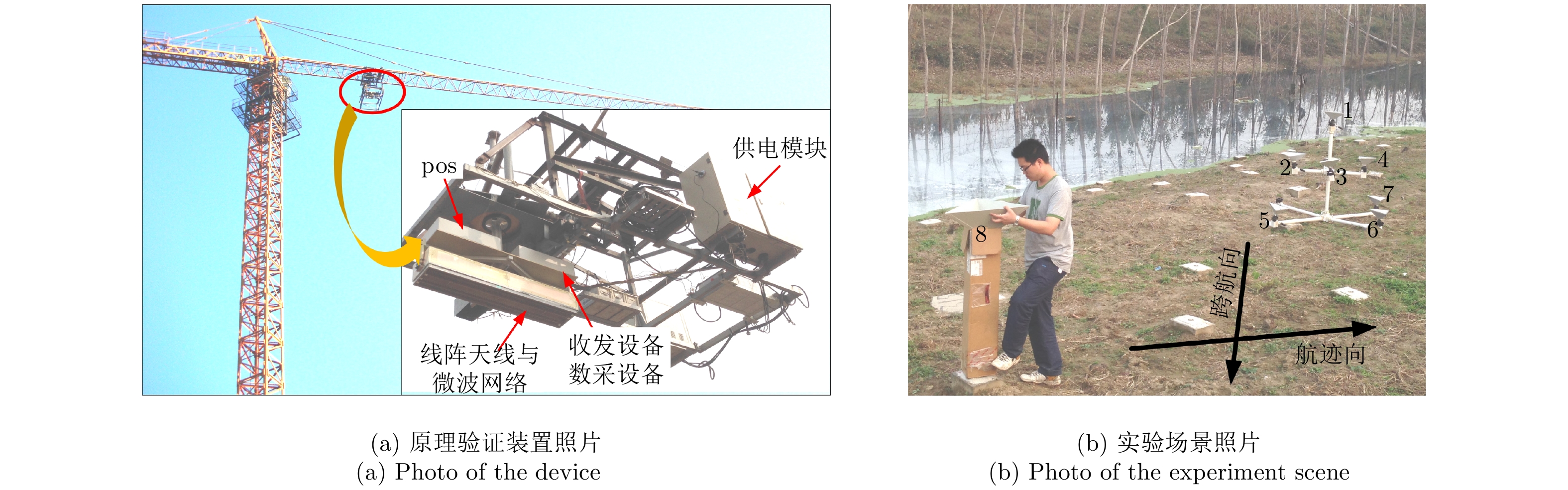
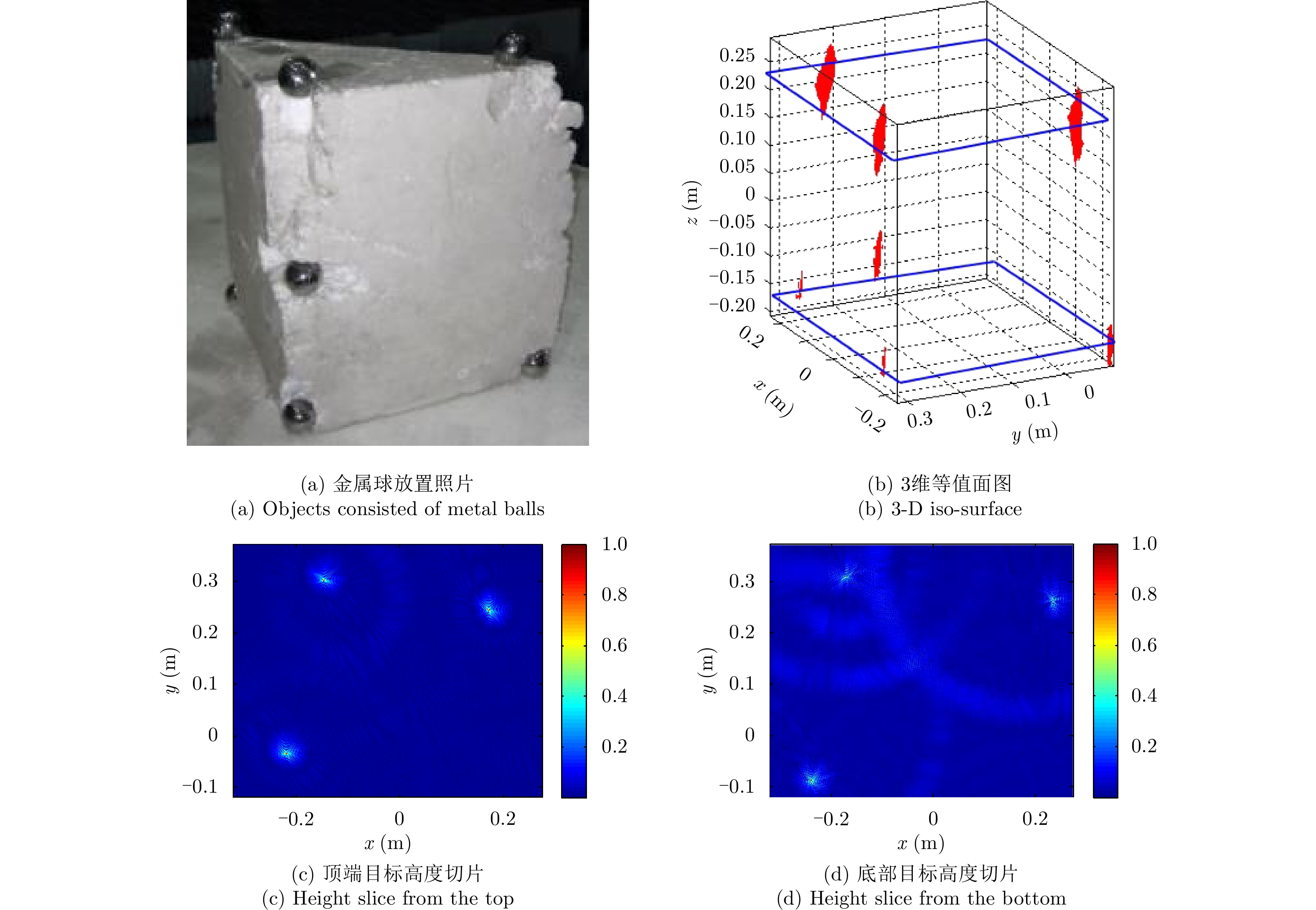
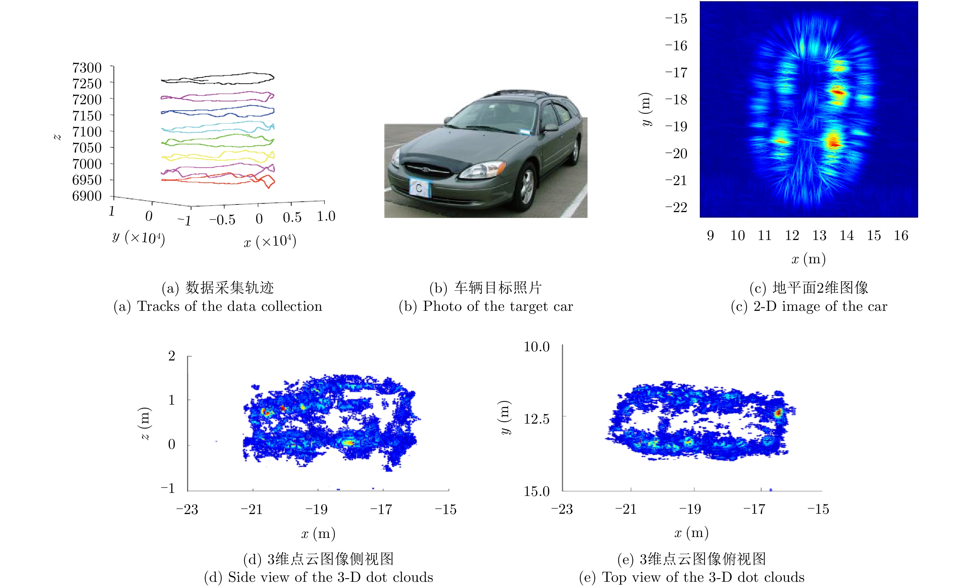
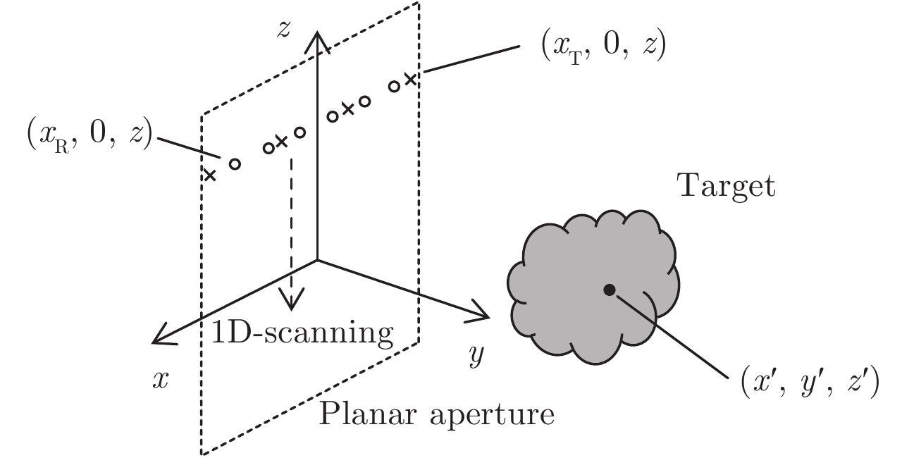
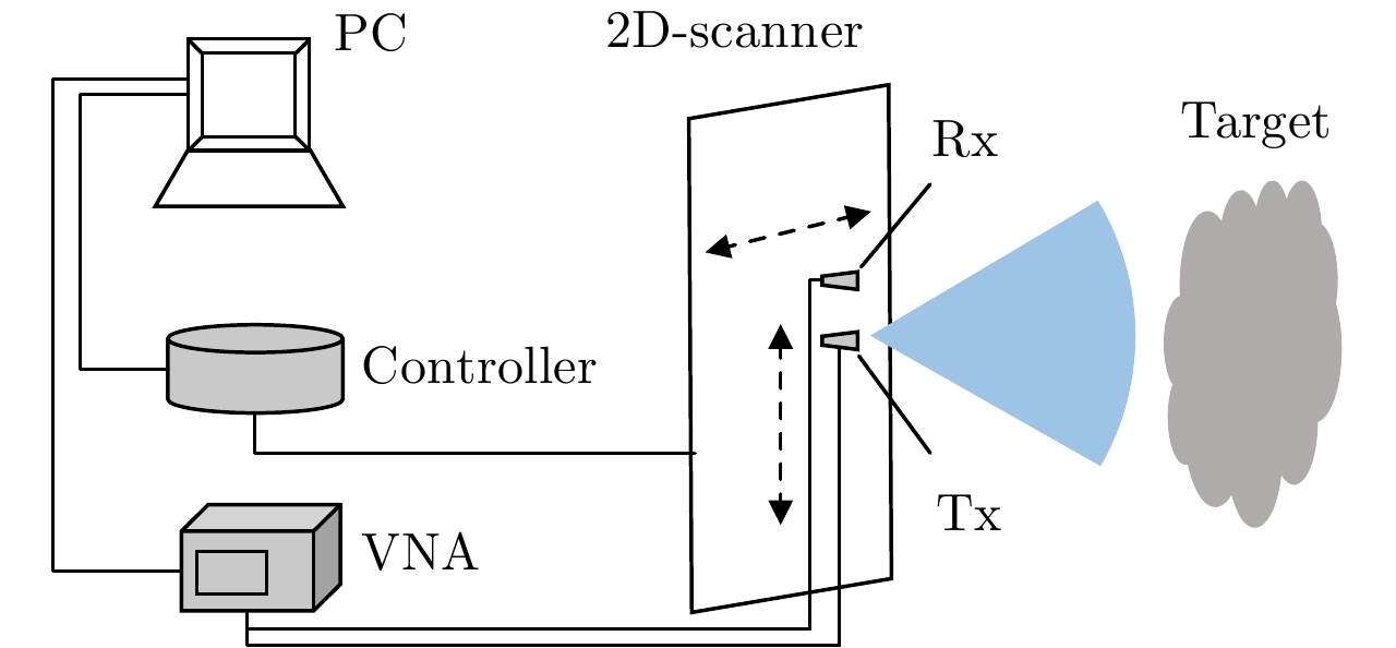
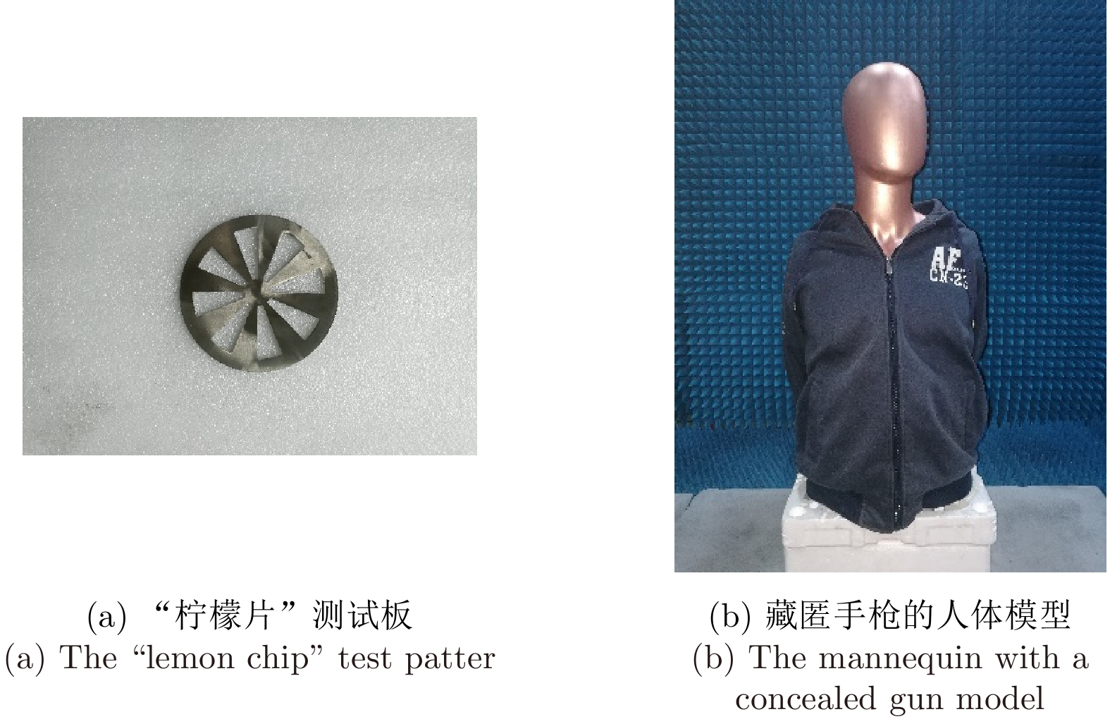
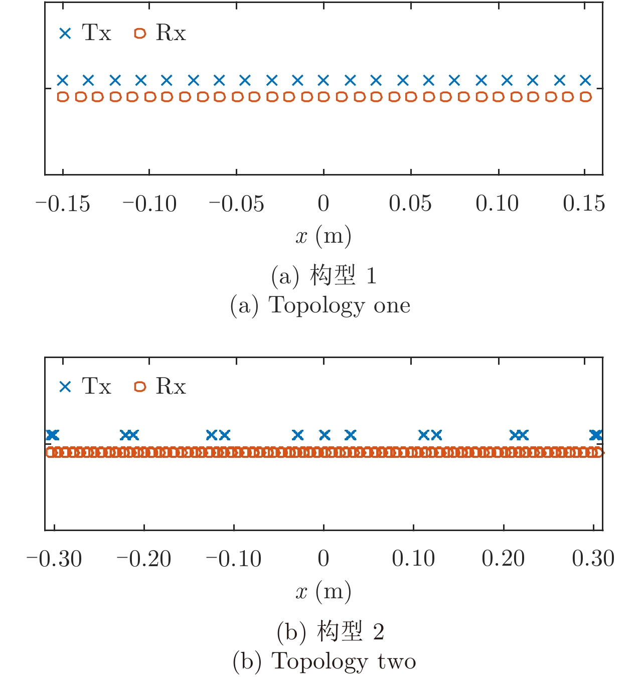
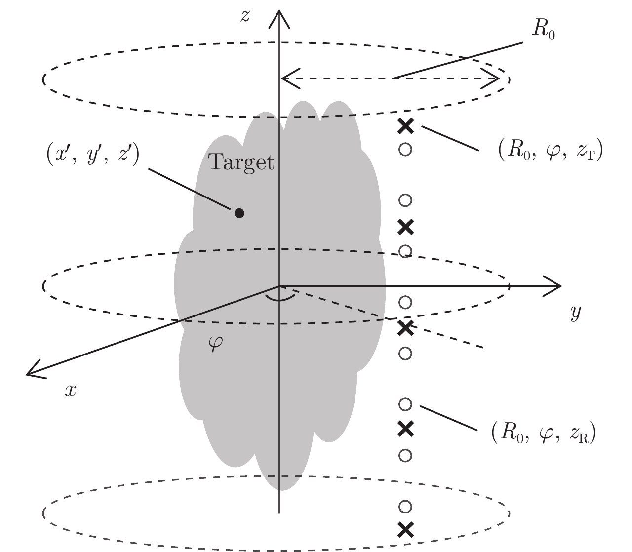
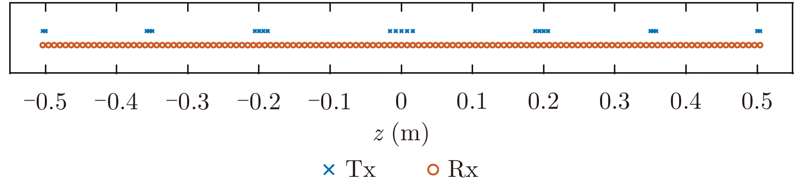
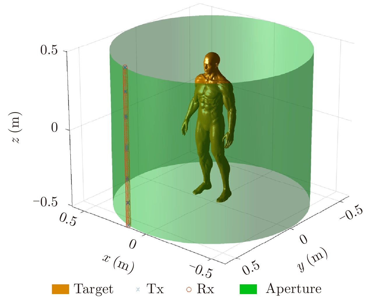
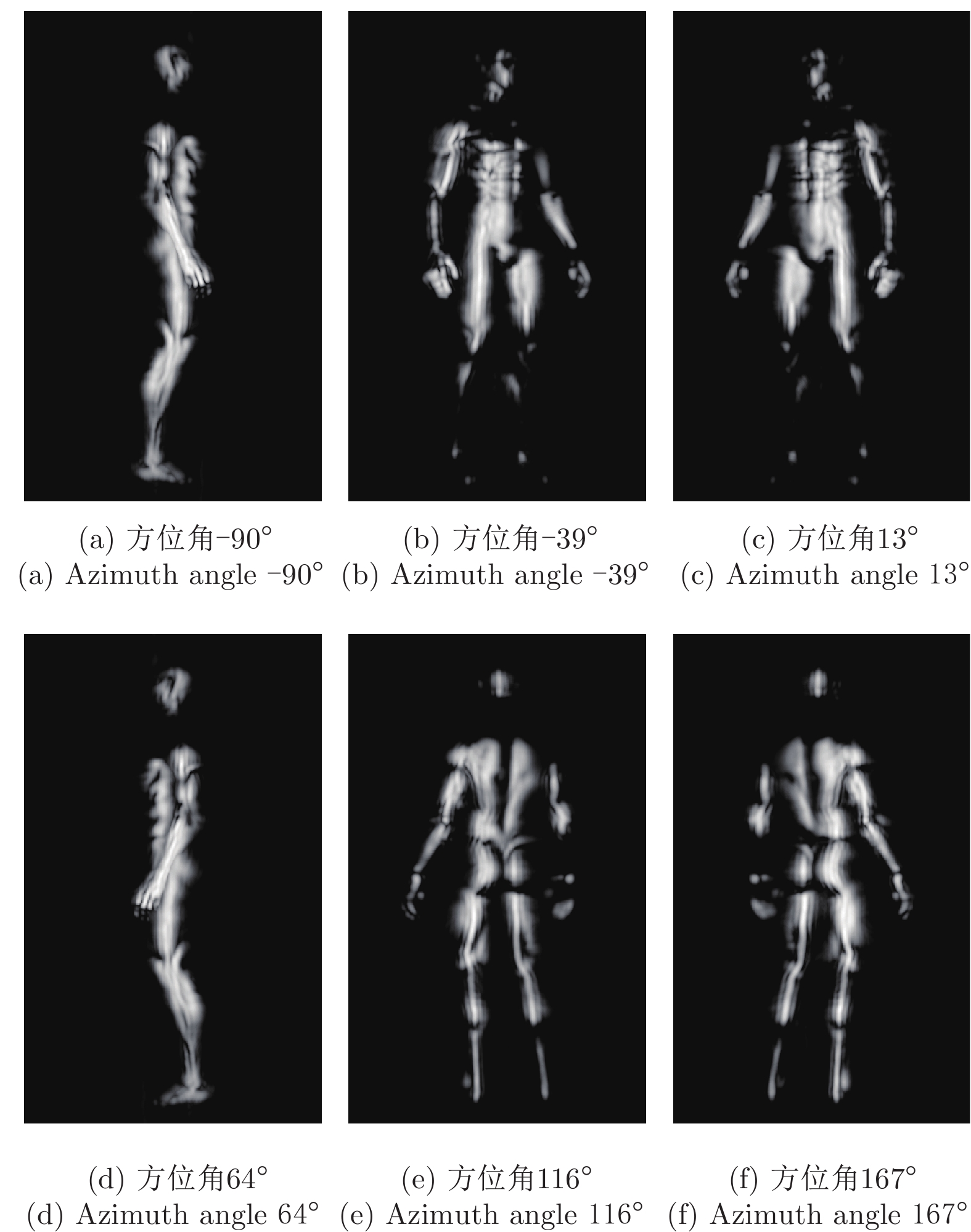
Near-field 3-D imaging based on a scanning array is an important application of Synthetic Aperture Radar (SAR) 3-D imaging technology for civil use. Compared with Single-Input-Single-Output (SISO) arrays, a Multi-Input-Multi-Output (MIMO) scanning system is a special imaging method characterized by high imaging quality, high array efficiency, loose requirements for antenna spacing and low cost. In this paper, two imaging regimes, namely, MIMO-planar scanning and MIMO cylindrical scanning, are described in terms of signal models, imaging algorithms, experimental systems, and imaging results. The results show the great application potential of the imaging technology in various scenarios.
Near-field 3-D imaging based on a scanning array is an important application of Synthetic Aperture Radar (SAR) 3-D imaging technology for civil use. Compared with Single-Input-Single-Output (SISO) arrays, a Multi-Input-Multi-Output (MIMO) scanning system is a special imaging method characterized by high imaging quality, high array efficiency, loose requirements for antenna spacing and low cost. In this paper, two imaging regimes, namely, MIMO-planar scanning and MIMO cylindrical scanning, are described in terms of signal models, imaging algorithms, experimental systems, and imaging results. The results show the great application potential of the imaging technology in various scenarios.


2018, 7(6): 685-695.
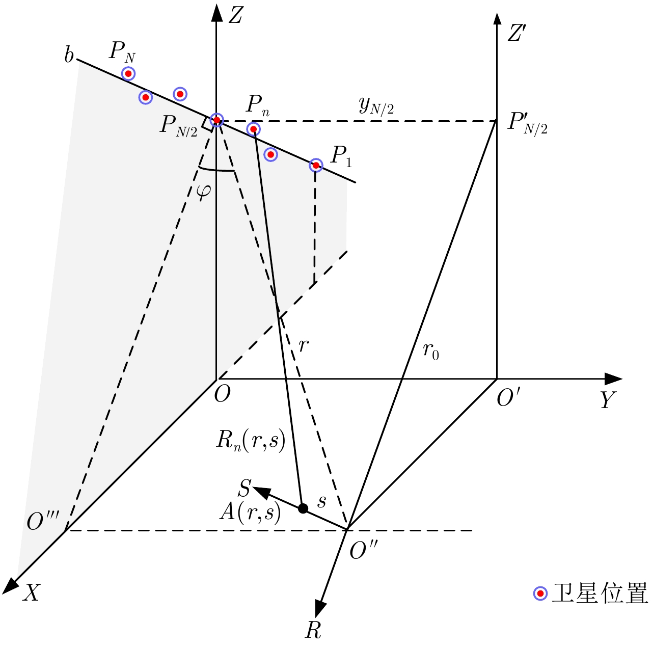
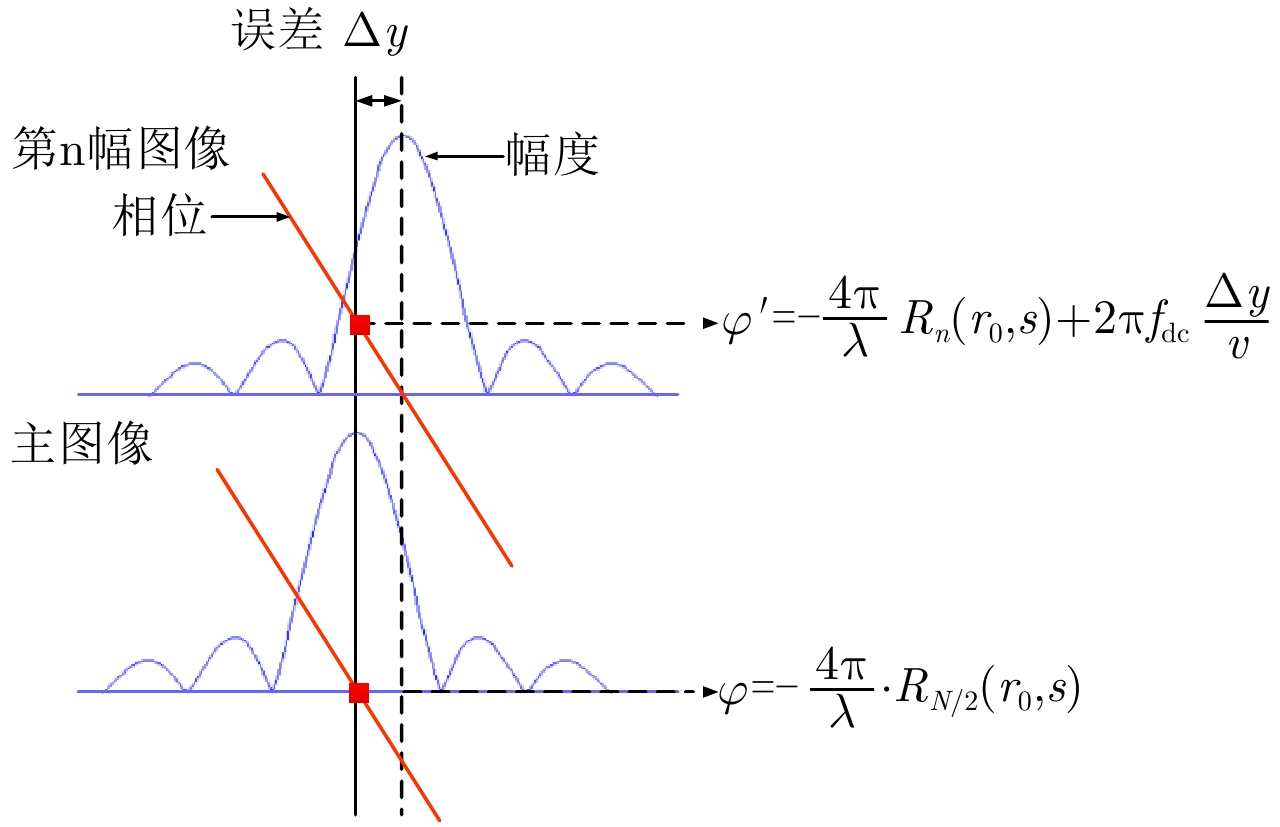
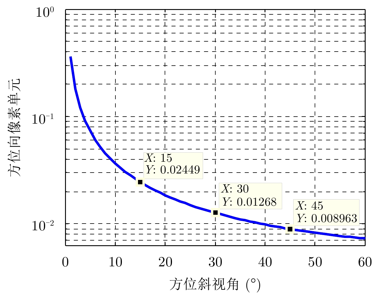
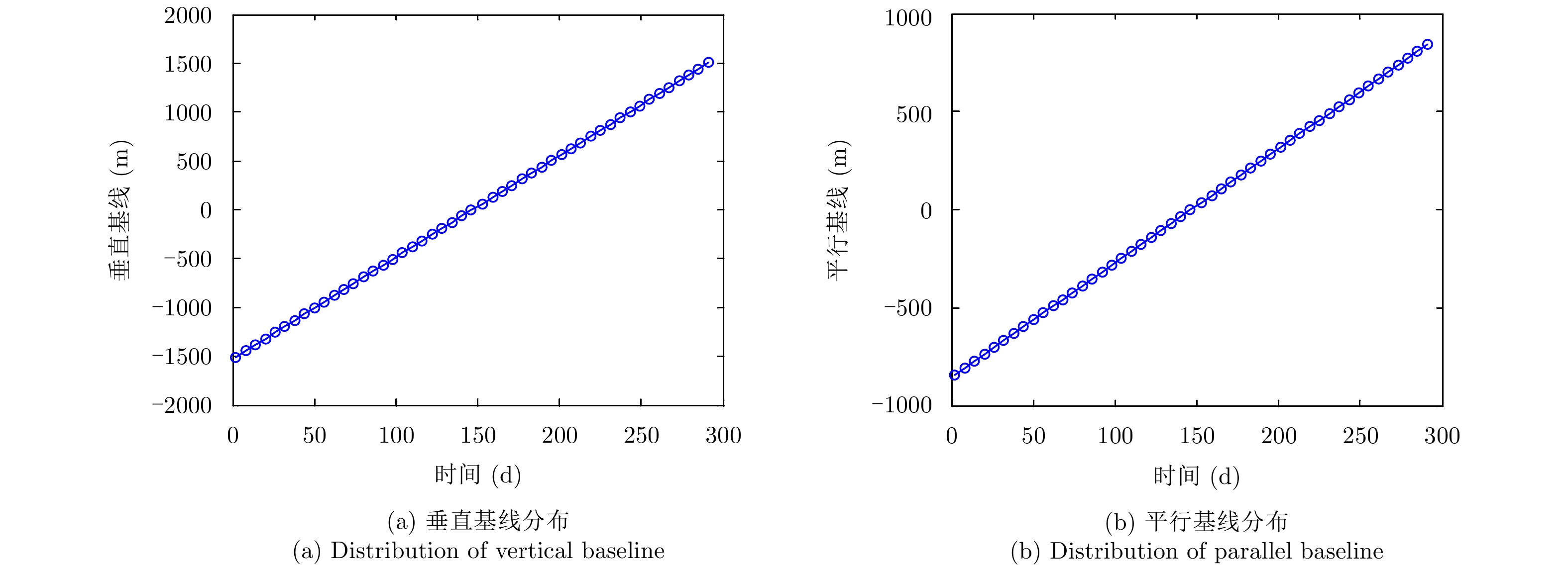
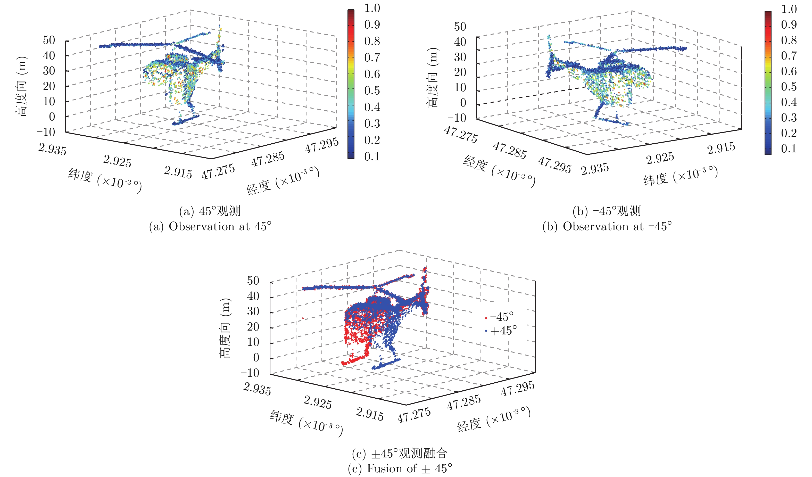
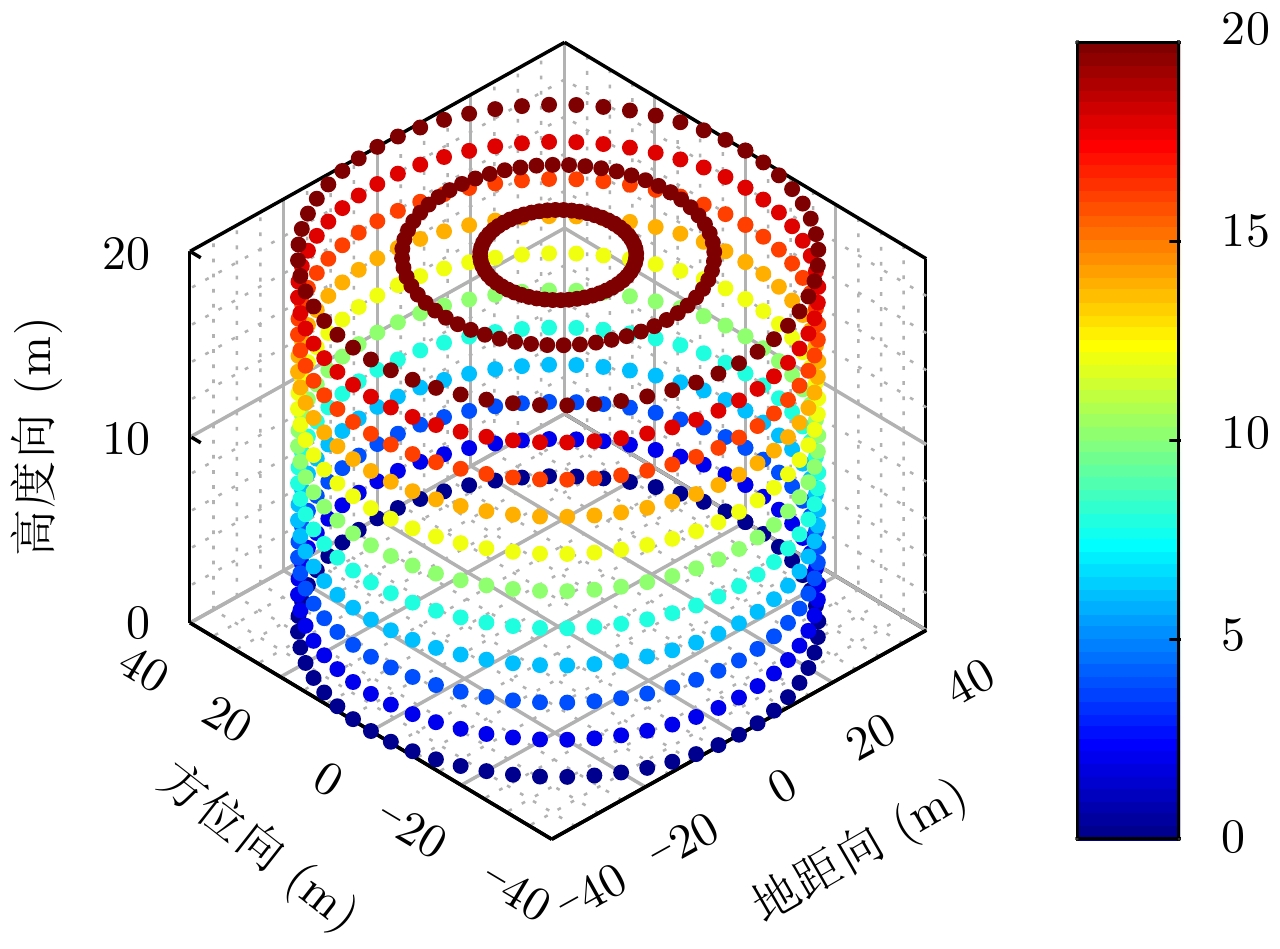
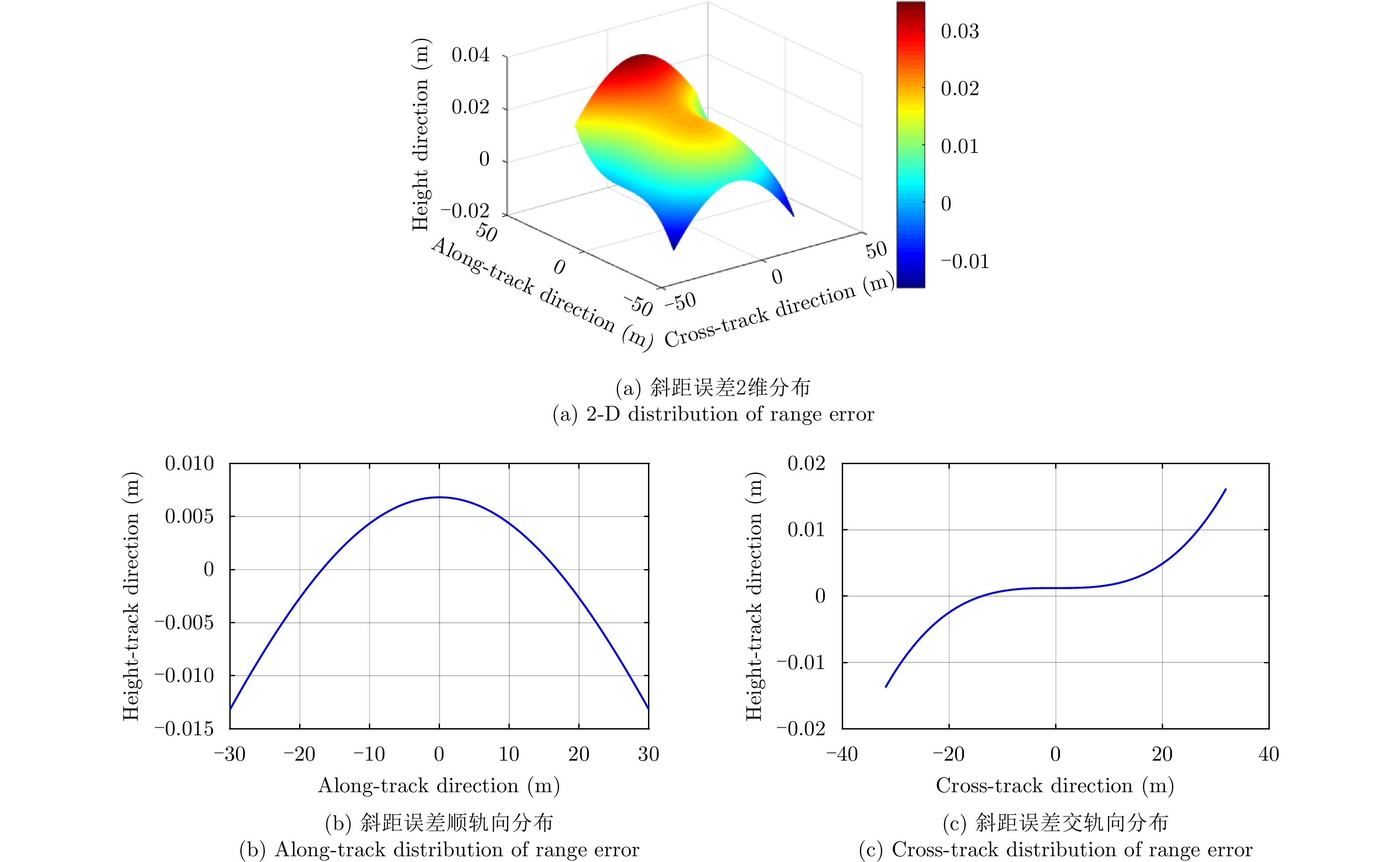
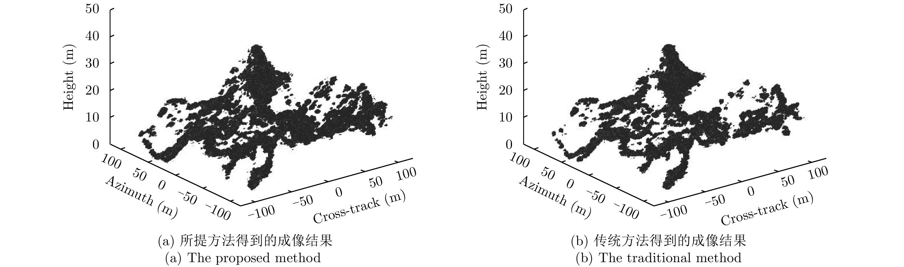
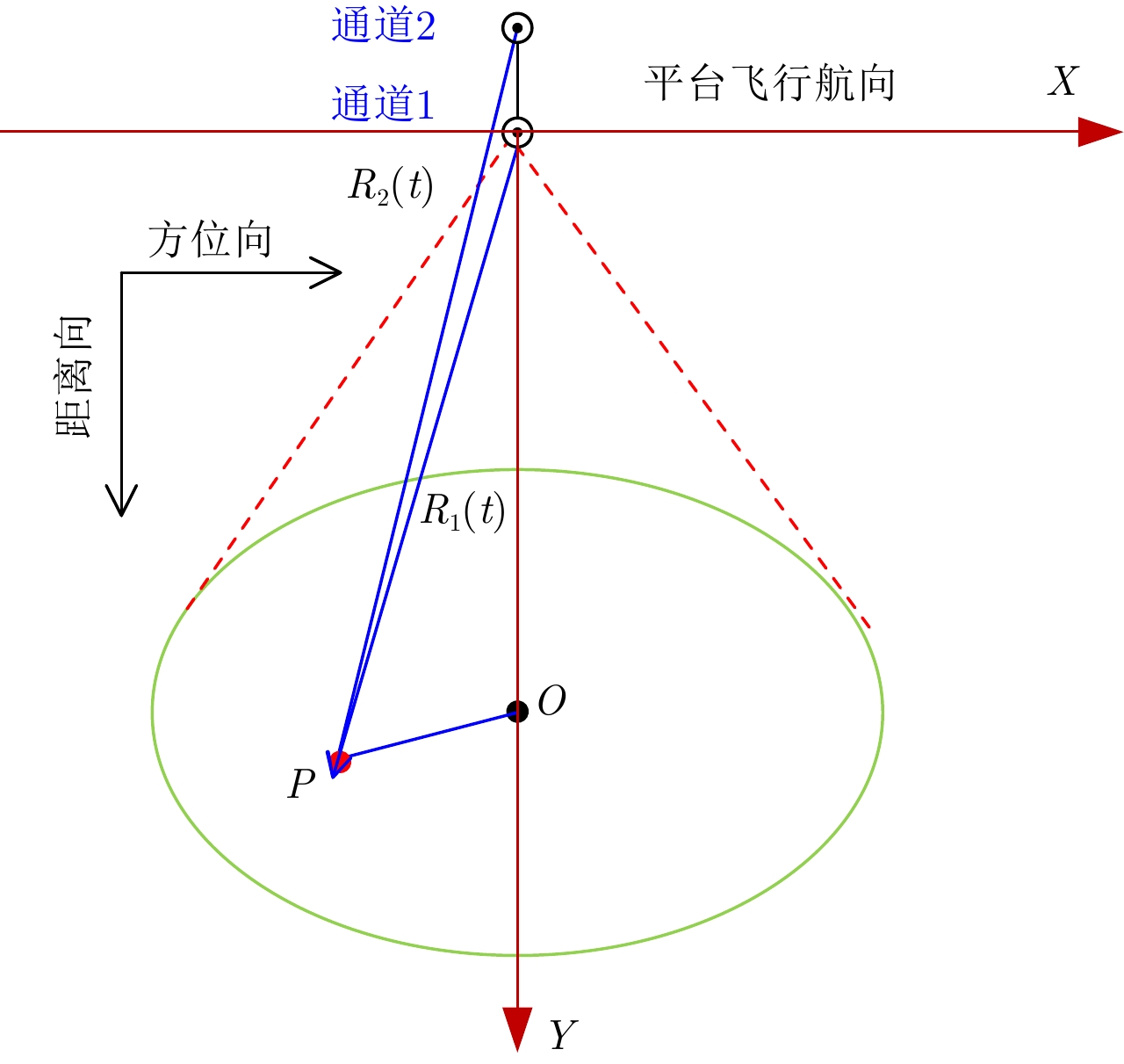
Traditional spaceborne Synthetic Aperture Radar (SAR) can acquire three-dimensional (3D) images by using multi-baseline SAR data, which solves the problem of layover in two-dimensional (2D) SAR image, however, there is still a problem of insufficient information acquisition caused by occlusion. Considering this, a 3D imaging algorithm for multi-azimuth-angle multi-baseline spaceborne SAR is proposed in this paper; this algorithm not only solves the problem of layover, but also reduces the occlusion area by fusing the 3D point clouds obtained under different azimuth angles and improves the information acquisition ability of spaceborne SAR. First, the observation model of multi-azimuth-angle multi-baseline spaceborne SAR is established, and it shows that the mathematical signal models of the multi-baseline SAR in the squint mode and broadside mode are the same, which provides theoretical support for the direct application of broadside 3D imaging algorithm to the 3D processing of squint mode. On this basis, the 3D imaging algorithm and processing flow of multi-azimuth-angle multi-baseline spaceborne SAR are presented. Finally, the effectivenesses of the squint 3D imaging method and 3D point clouds fusion method are verified by point targets simulation experiment with 45° azimuth angle and helicopter simulation experiments with 45° and –45° azimuth angles, respectively.
Traditional spaceborne Synthetic Aperture Radar (SAR) can acquire three-dimensional (3D) images by using multi-baseline SAR data, which solves the problem of layover in two-dimensional (2D) SAR image, however, there is still a problem of insufficient information acquisition caused by occlusion. Considering this, a 3D imaging algorithm for multi-azimuth-angle multi-baseline spaceborne SAR is proposed in this paper; this algorithm not only solves the problem of layover, but also reduces the occlusion area by fusing the 3D point clouds obtained under different azimuth angles and improves the information acquisition ability of spaceborne SAR. First, the observation model of multi-azimuth-angle multi-baseline spaceborne SAR is established, and it shows that the mathematical signal models of the multi-baseline SAR in the squint mode and broadside mode are the same, which provides theoretical support for the direct application of broadside 3D imaging algorithm to the 3D processing of squint mode. On this basis, the 3D imaging algorithm and processing flow of multi-azimuth-angle multi-baseline spaceborne SAR are presented. Finally, the effectivenesses of the squint 3D imaging method and 3D point clouds fusion method are verified by point targets simulation experiment with 45° azimuth angle and helicopter simulation experiments with 45° and –45° azimuth angles, respectively.


2018, 7(6): 696-704.
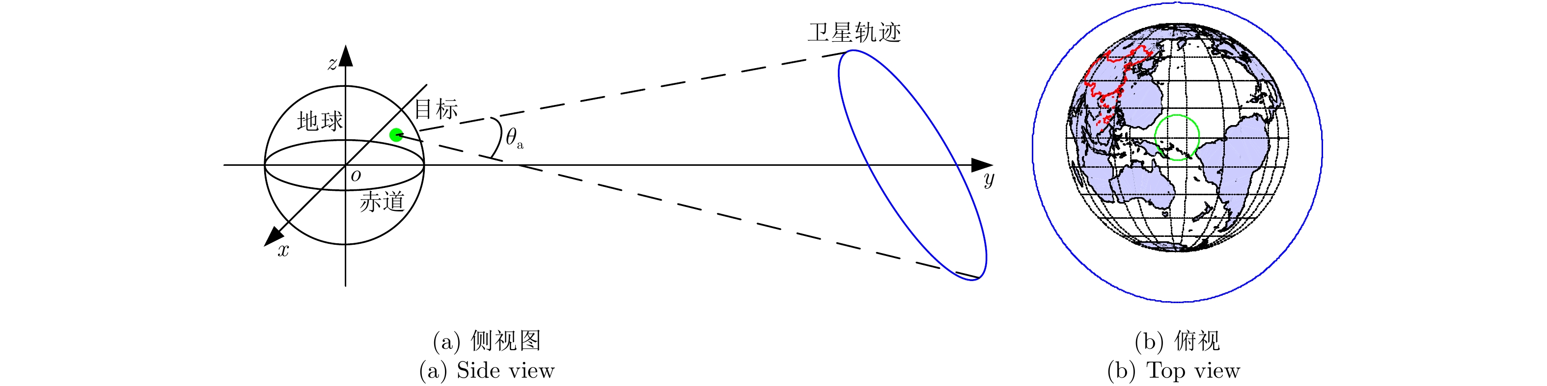
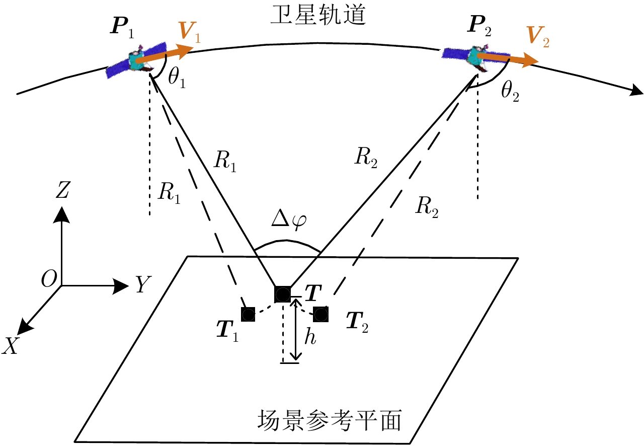
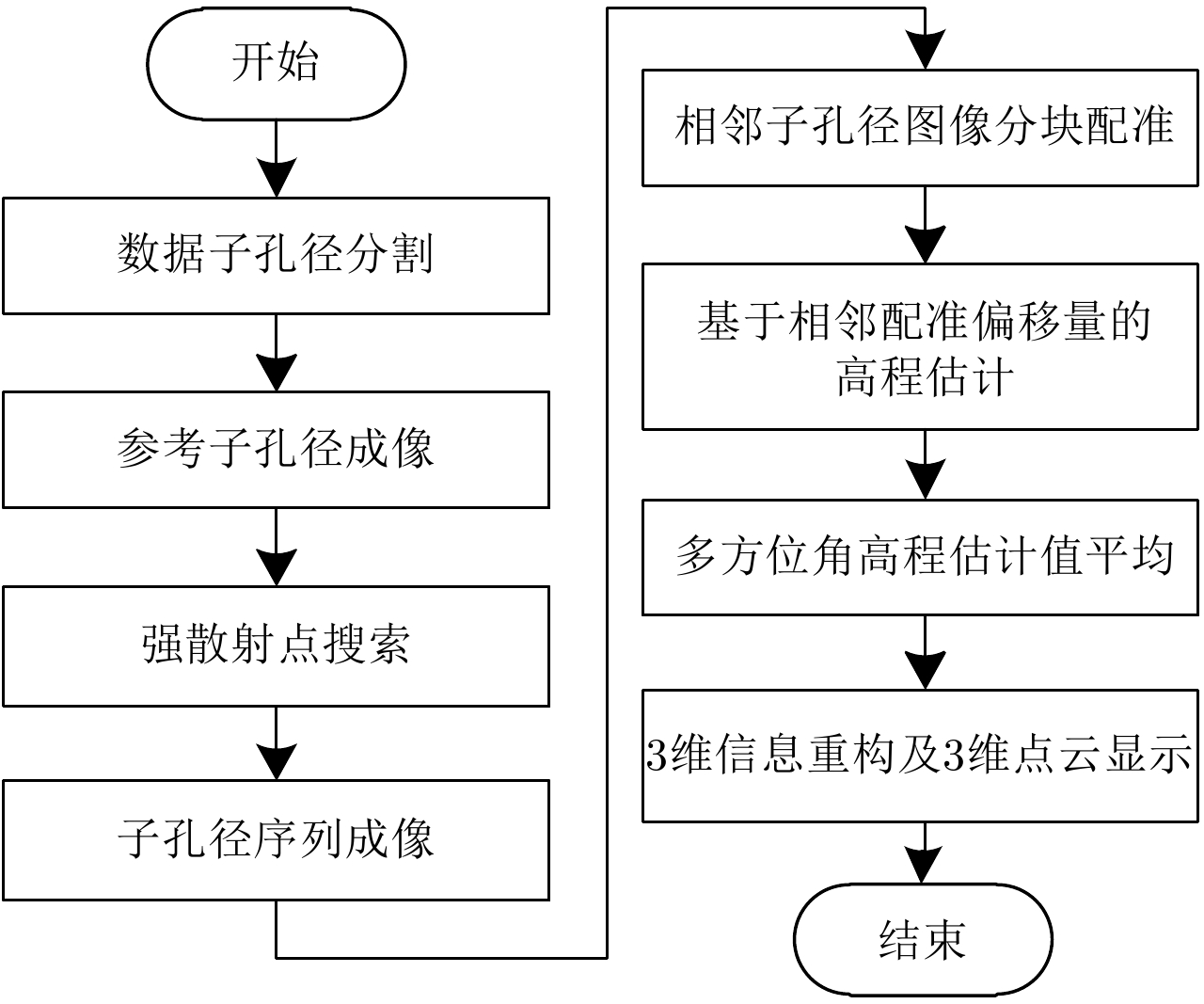
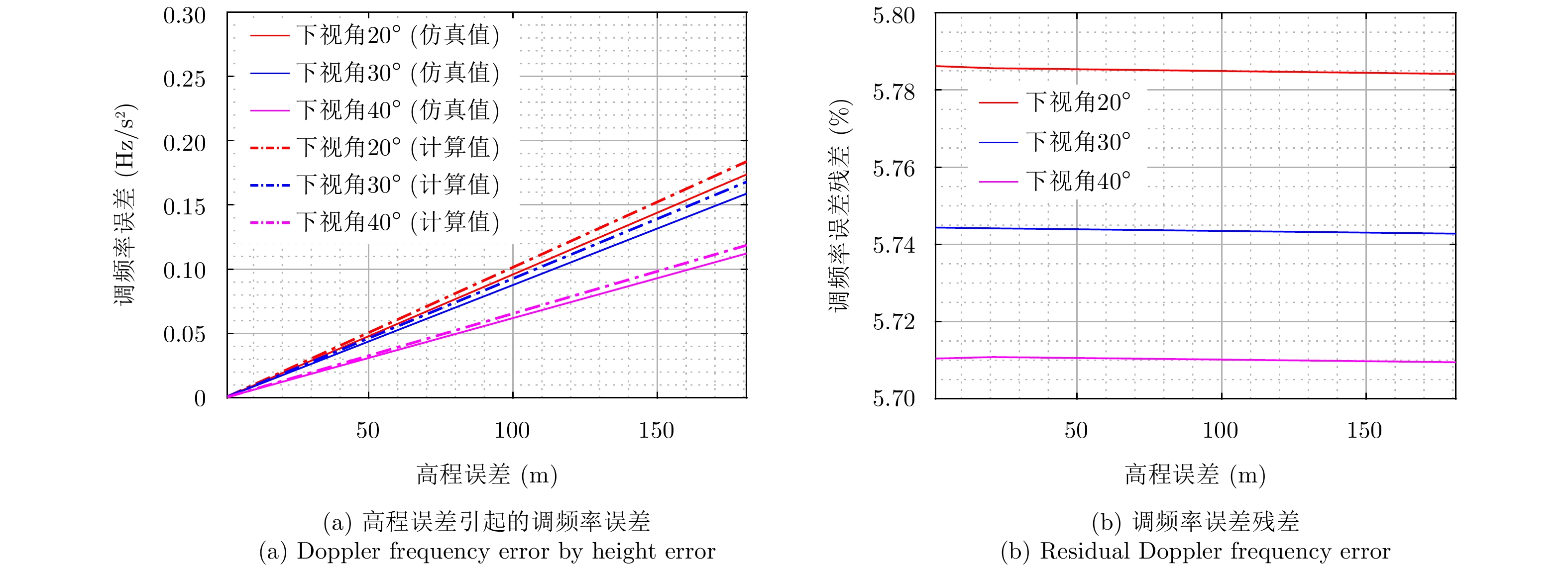
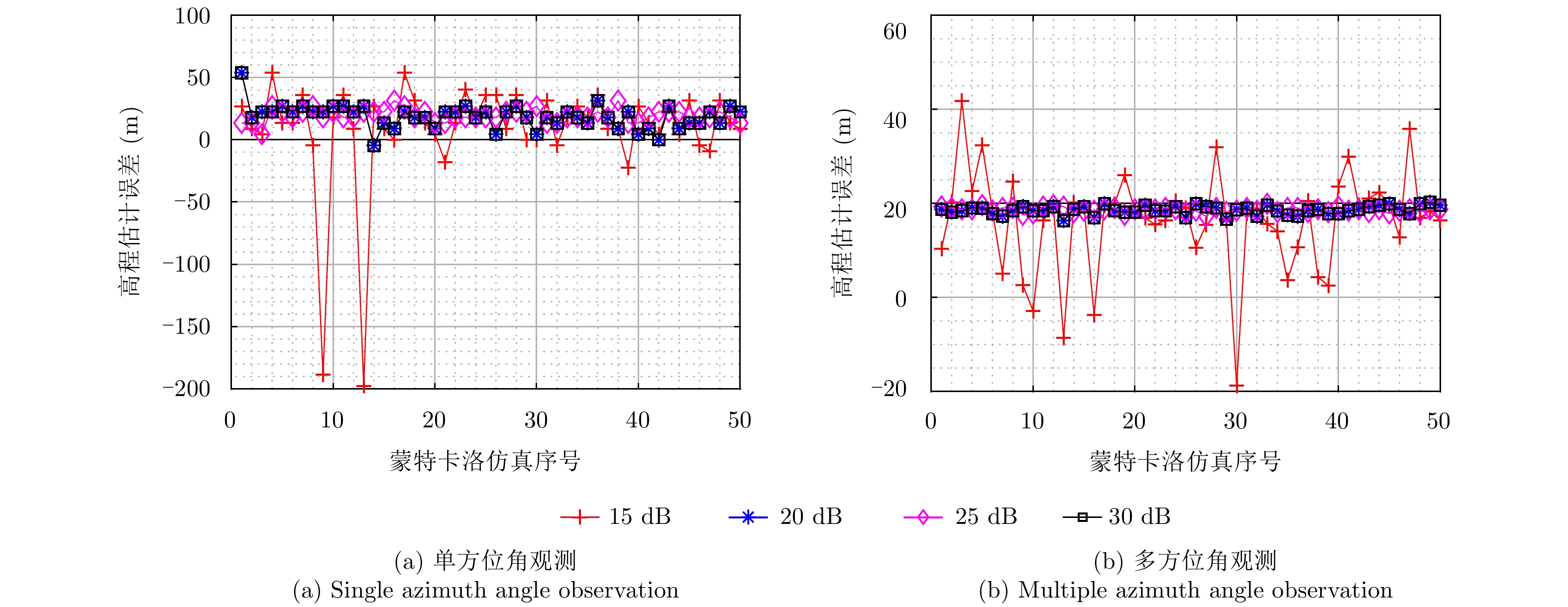
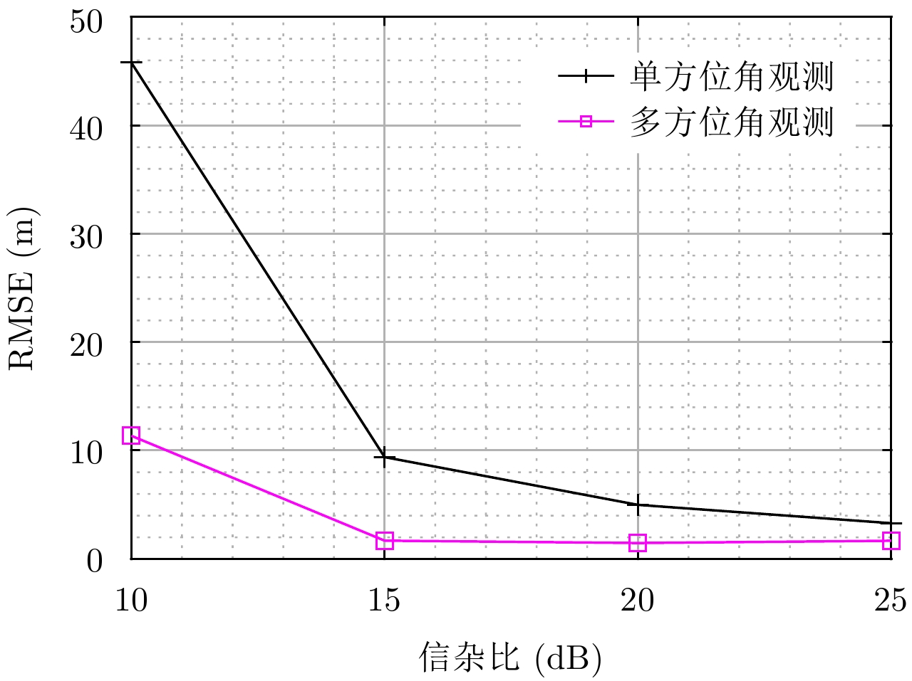
Using azimuth beam steering, space-borne Synthetic Aperture Radar (SAR) can observe from multiple azimuth angle in single pass. During multiple azimuth angle observation, the satellite orbit is equivalent to long three-dimensional (3-D) curvilinear array, which has the potential for 3-D imaging. Sampling by space-borne multiple azimuth angle SAR is sparse in height dimension, which makes unambiguous 3-D imaging by 3-D fast Fourier transform infeasible. Besides, the complex relationship between the targets’ projection in multi-angle SAR images and the height error is difficult to determine. To overcome this limitation, in this paper, we present a 3-D imaging method based on joint multiple azimuth angle Doppler frequency rate estimation. First, a relationship is proposed between the height error and Doppler frequency rate at different azimuth angle. Then, the Doppler frequency modulation rate error is estimated by Map Drift (MD) technique. Next, the height estimation results of different azimuth angle are combined to improve the estimation accuracy. From the estimated height and the target location in the SAR images, 3-D geometric information is retrieved and 3-D imaging is achieved. Our simulation experiments validate that the height estimation can achieve an accuracy of few meters with the proposed method.
Using azimuth beam steering, space-borne Synthetic Aperture Radar (SAR) can observe from multiple azimuth angle in single pass. During multiple azimuth angle observation, the satellite orbit is equivalent to long three-dimensional (3-D) curvilinear array, which has the potential for 3-D imaging. Sampling by space-borne multiple azimuth angle SAR is sparse in height dimension, which makes unambiguous 3-D imaging by 3-D fast Fourier transform infeasible. Besides, the complex relationship between the targets’ projection in multi-angle SAR images and the height error is difficult to determine. To overcome this limitation, in this paper, we present a 3-D imaging method based on joint multiple azimuth angle Doppler frequency rate estimation. First, a relationship is proposed between the height error and Doppler frequency rate at different azimuth angle. Then, the Doppler frequency modulation rate error is estimated by Map Drift (MD) technique. Next, the height estimation results of different azimuth angle are combined to improve the estimation accuracy. From the estimated height and the target location in the SAR images, 3-D geometric information is retrieved and 3-D imaging is achieved. Our simulation experiments validate that the height estimation can achieve an accuracy of few meters with the proposed method.

2018, 7(6): 705-716.
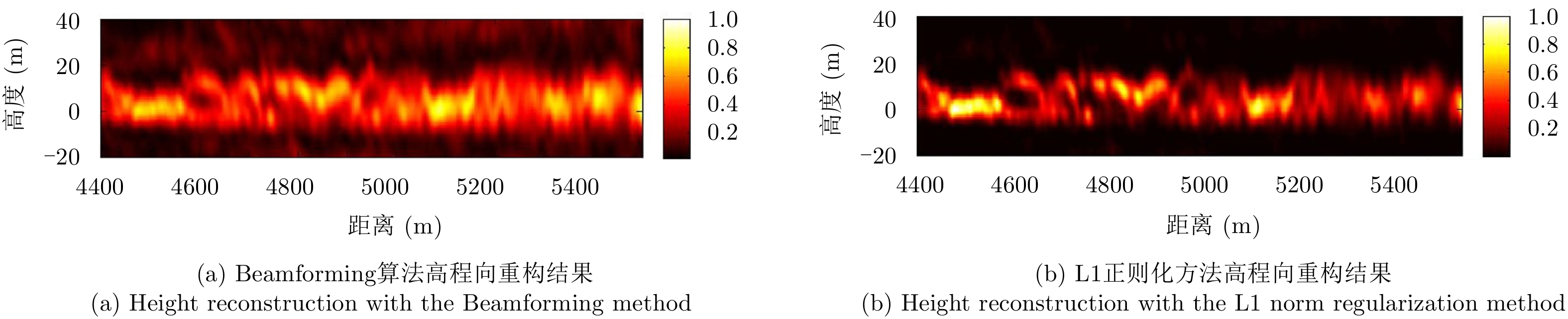
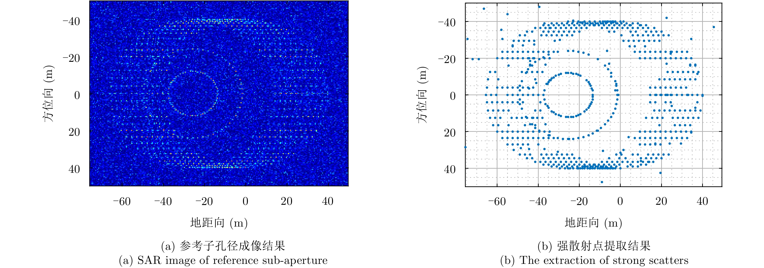
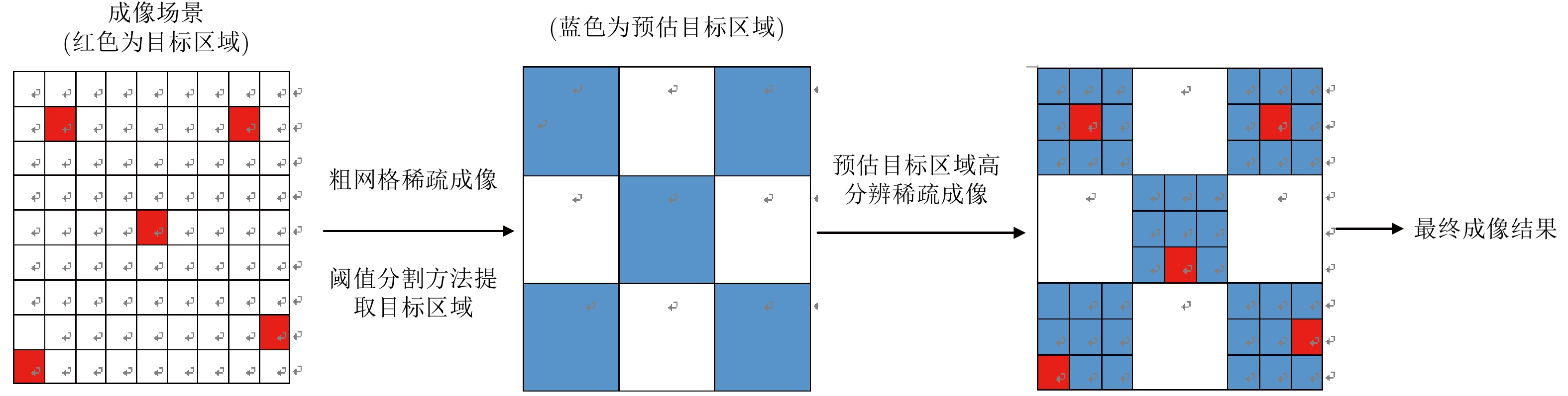
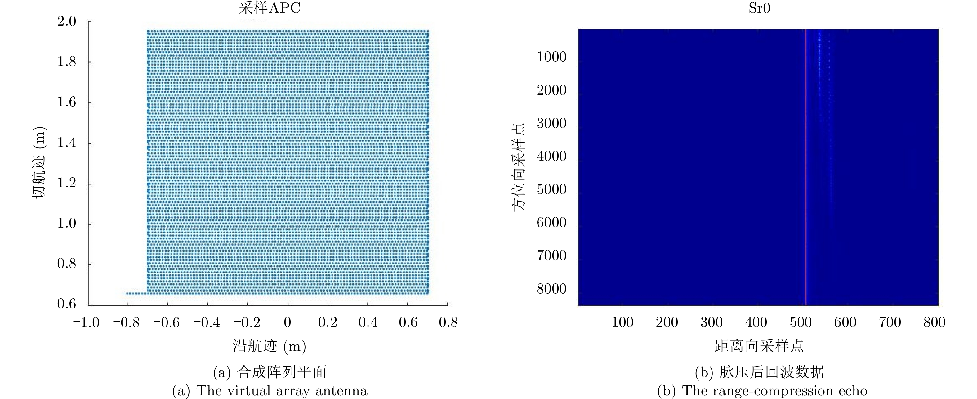
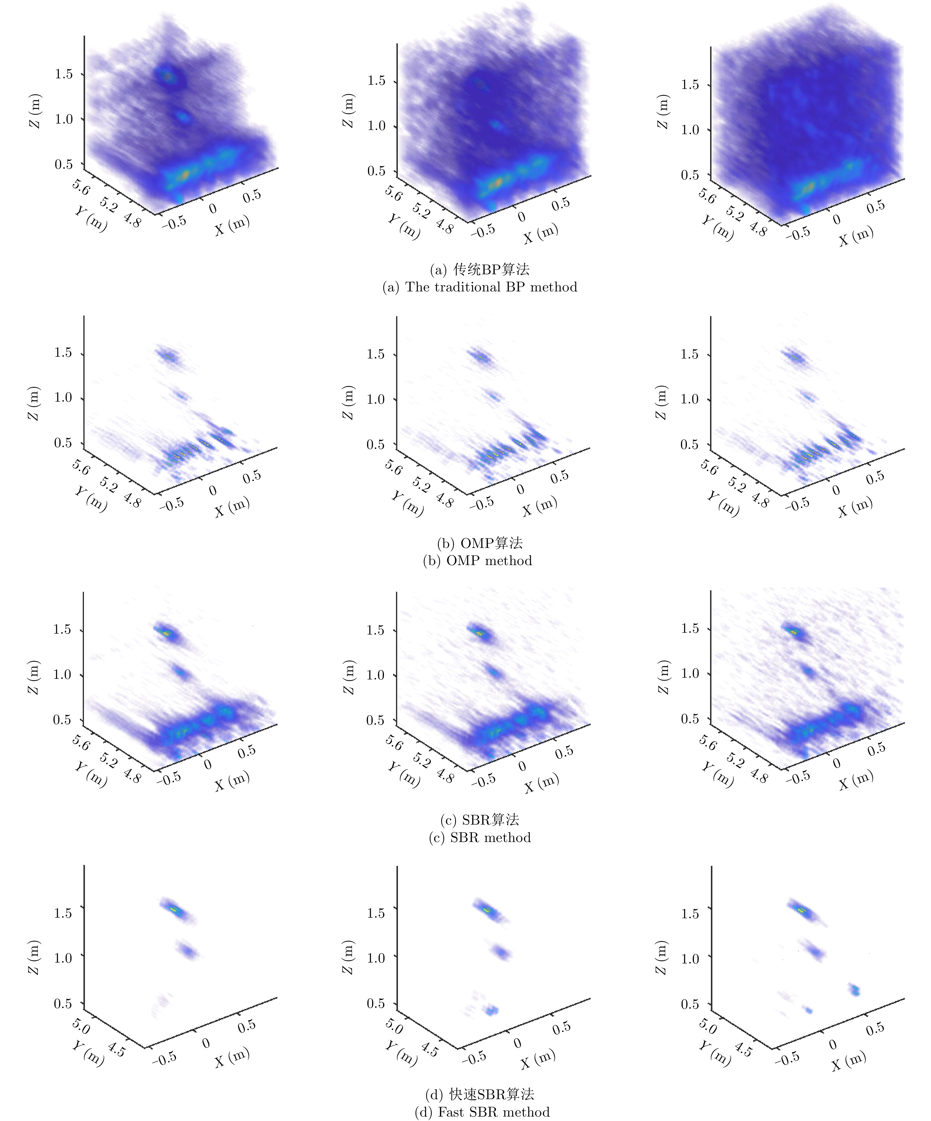
Linear Array Synthetic Aperture Radar (LASAR) is a novel and promising radar imaging technique. It is difficult to achieve high-resolution LASAR three-dimensional (3D) imaging using the traditional imaging methods based on match filter, because of limitations by the sizes of the linear array antenna and the platform. In this paper, by exploiting the prior distribution of the LASAR echoes and the observed scene, an LASAR high-resolution 3D algorithm based on sparse Bayesian regularization is proposed. The algorithm first combines the Bayesian principle and maximum likelihood estimation theory, and then a sparse Bayesian minimum cost function is constructed for LASAR target recovery. Second, using an iterative regularization reconstruction method, high-resolution imaging of LASAR sparse targets is achieved by solving a joint-norms optimization problem. In addition, for the problem of a large amount of sparse Bayesian regularization imaging, combined with the position prediction fast imaging idea, the threshold segmentation algorithm is used to extract the strong target of sparse coarse imaging, and then the algorithm operation efficiency is improved. Simulation and experiment results are presented to confirm the effectiveness of the algorithm.
Linear Array Synthetic Aperture Radar (LASAR) is a novel and promising radar imaging technique. It is difficult to achieve high-resolution LASAR three-dimensional (3D) imaging using the traditional imaging methods based on match filter, because of limitations by the sizes of the linear array antenna and the platform. In this paper, by exploiting the prior distribution of the LASAR echoes and the observed scene, an LASAR high-resolution 3D algorithm based on sparse Bayesian regularization is proposed. The algorithm first combines the Bayesian principle and maximum likelihood estimation theory, and then a sparse Bayesian minimum cost function is constructed for LASAR target recovery. Second, using an iterative regularization reconstruction method, high-resolution imaging of LASAR sparse targets is achieved by solving a joint-norms optimization problem. In addition, for the problem of a large amount of sparse Bayesian regularization imaging, combined with the position prediction fast imaging idea, the threshold segmentation algorithm is used to extract the strong target of sparse coarse imaging, and then the algorithm operation efficiency is improved. Simulation and experiment results are presented to confirm the effectiveness of the algorithm.


2018, 7(6): 717-729.
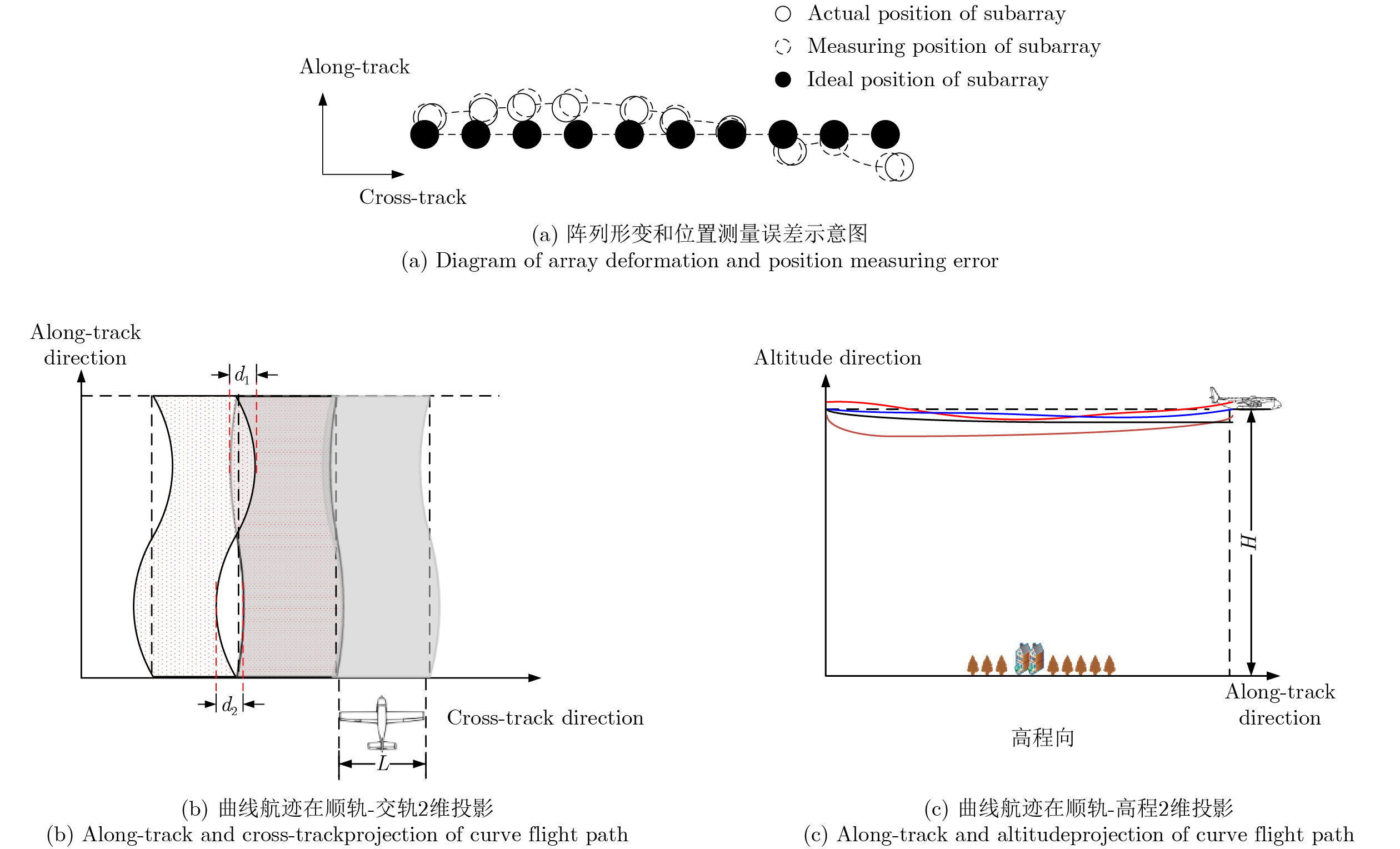
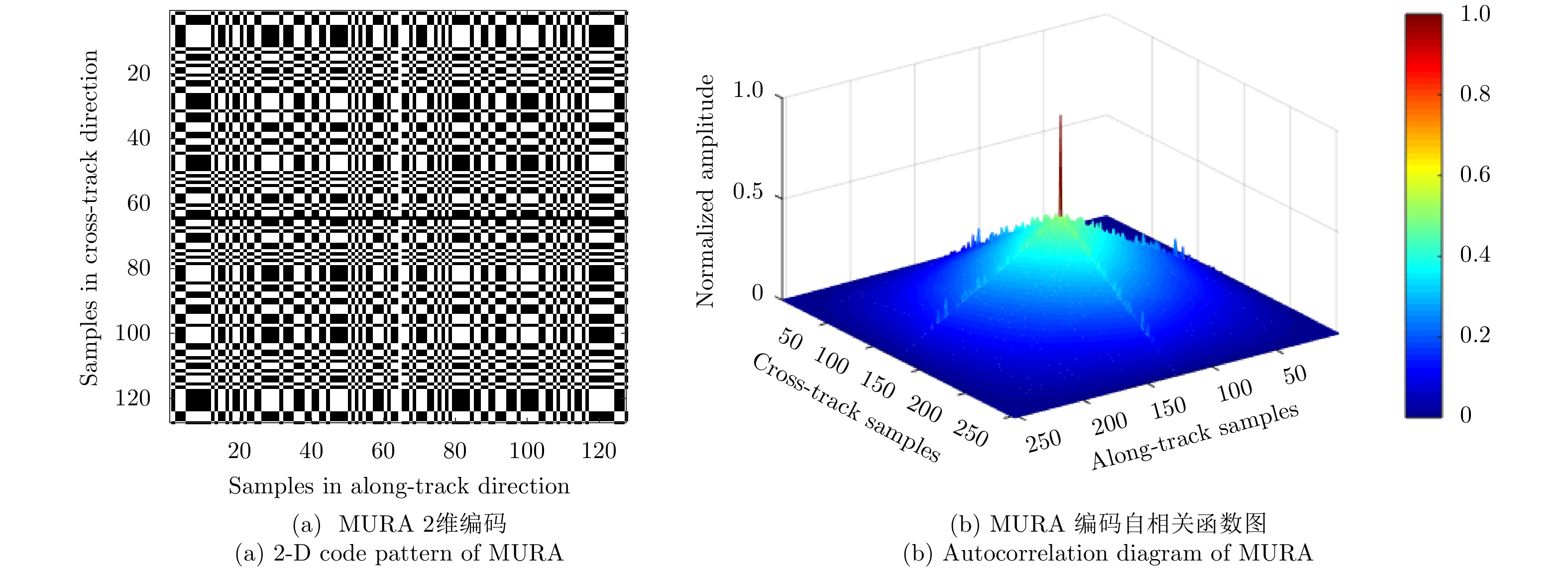
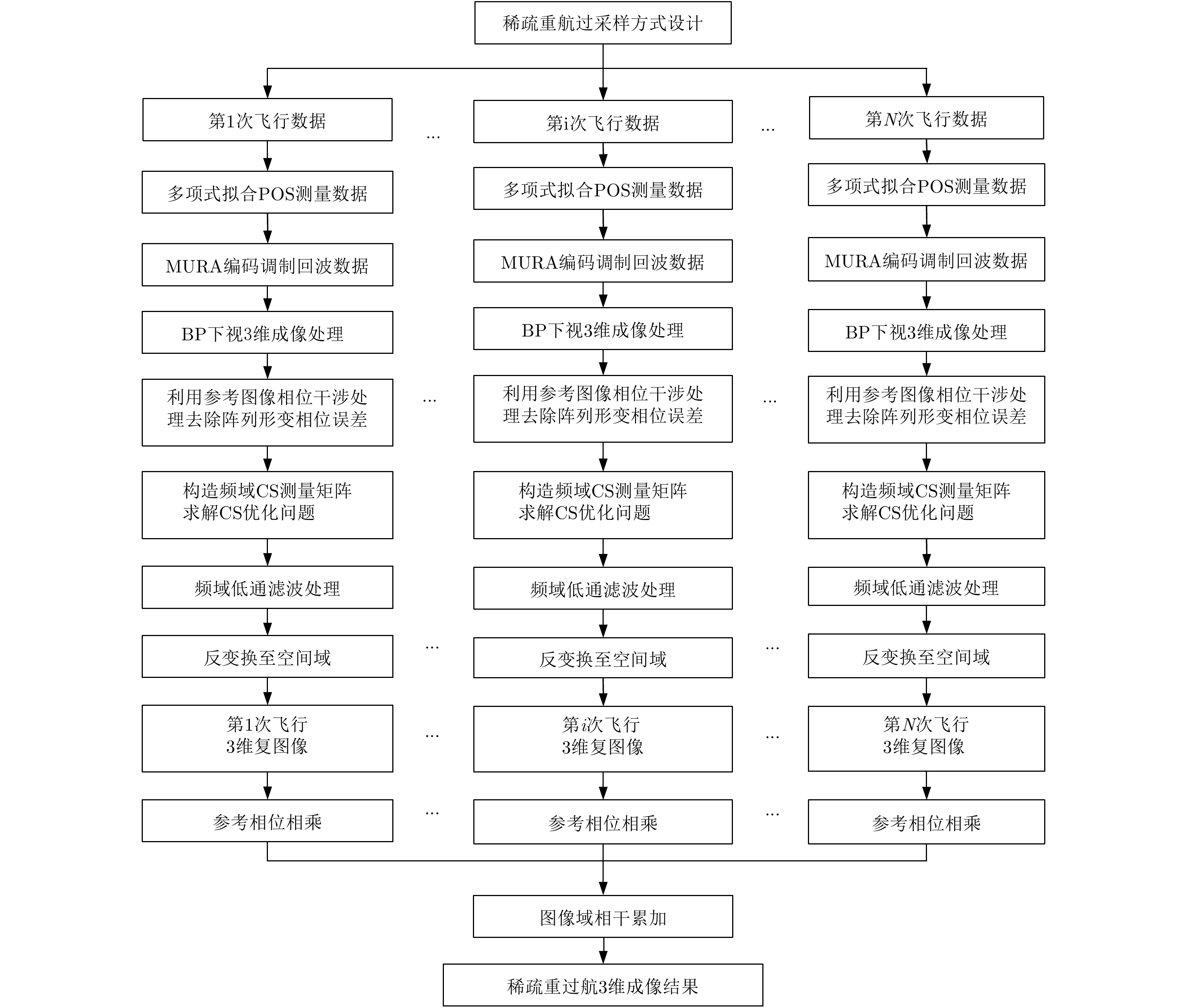
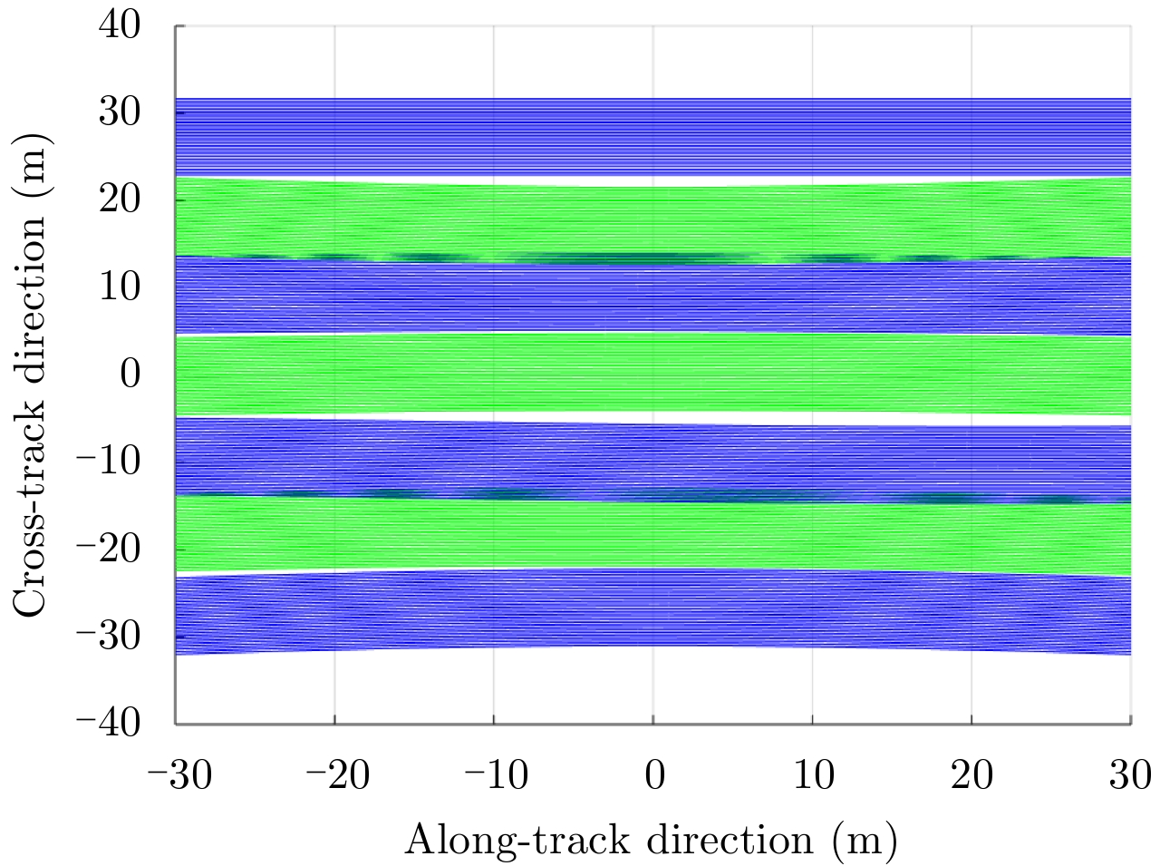
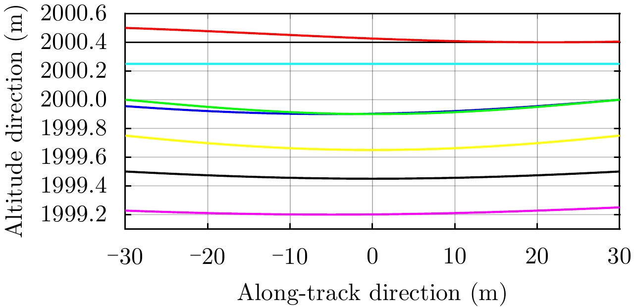
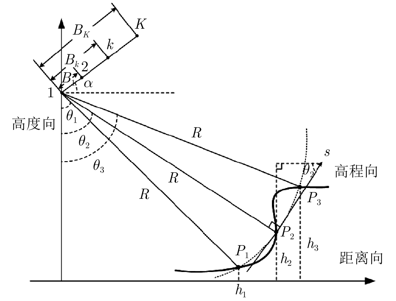
In this study, we adopt a criterion of Barker code to generate a high-resolution image from sparse flight samples to establish a three-dimensional (3-D) imaging model of airborne array SAR. Under the condition of motion error, we utilize the Modified Uniformly Redundant Arrays (MURA) modulation and 3-D Back Projection (BP) algorithm to obtain 3-D complex image pairs under each flight. Based on interferometry and Compressed Sensing (CS) in frequency domain, the array deformation error compensation is realized. The phases of 3-D complex image formed by the echo corresponding to negative MURA modulation are referred to perform phase compensation on each single-pass complex image to restore the image phase relation of each flight. Coherent accumulation of each complex image is implemented to realize high-resolution 3-D imaging under sparse flight sampling. Simulation analysis and experimental data verify the feasibility of the proposed method.
In this study, we adopt a criterion of Barker code to generate a high-resolution image from sparse flight samples to establish a three-dimensional (3-D) imaging model of airborne array SAR. Under the condition of motion error, we utilize the Modified Uniformly Redundant Arrays (MURA) modulation and 3-D Back Projection (BP) algorithm to obtain 3-D complex image pairs under each flight. Based on interferometry and Compressed Sensing (CS) in frequency domain, the array deformation error compensation is realized. The phases of 3-D complex image formed by the echo corresponding to negative MURA modulation are referred to perform phase compensation on each single-pass complex image to restore the image phase relation of each flight. Coherent accumulation of each complex image is implemented to realize high-resolution 3-D imaging under sparse flight sampling. Simulation analysis and experimental data verify the feasibility of the proposed method.


2018, 7(6): 730-739.
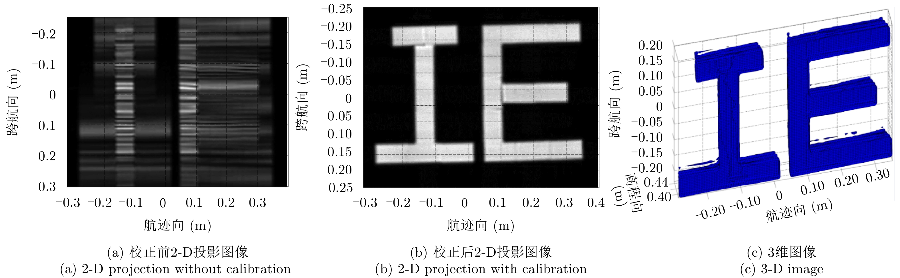
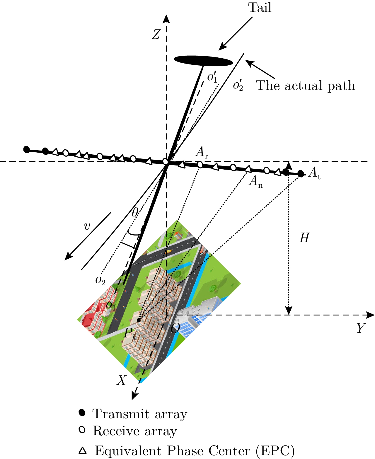
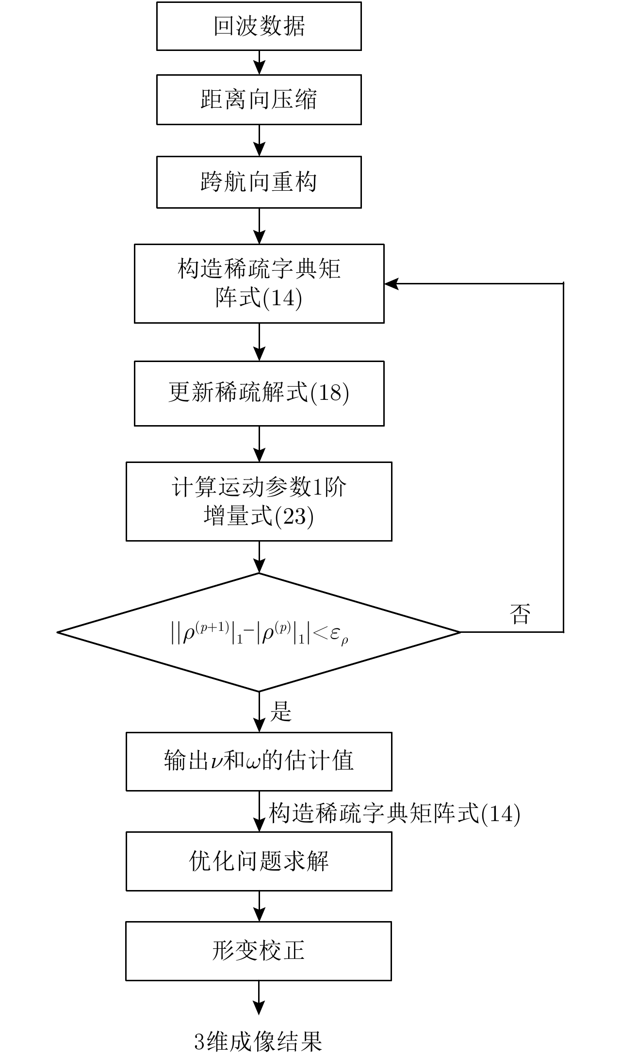
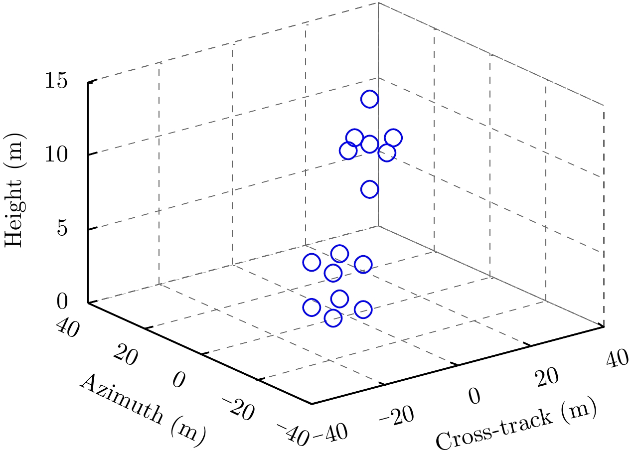
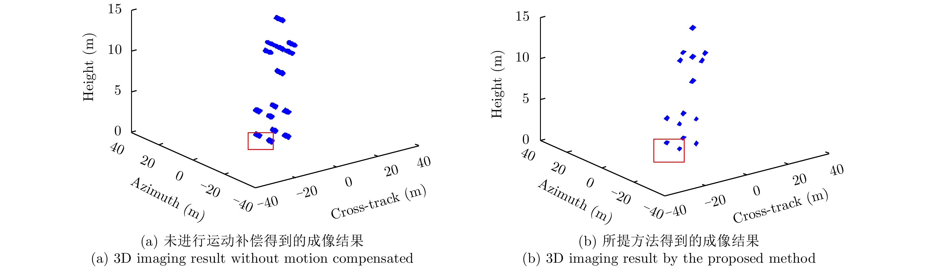
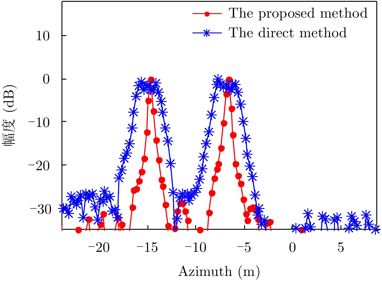
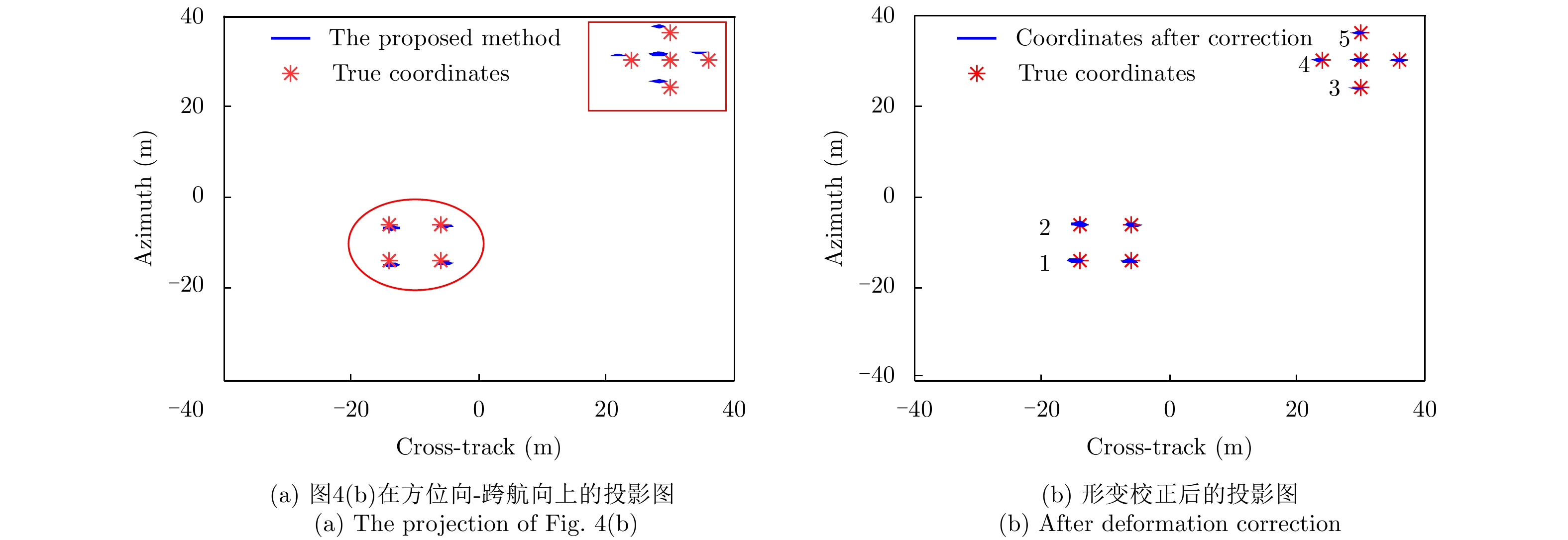
In the presence of yaw angular velocity, a body will deviate from its ideal flight path, which will affect imaging of Downward-Looking Sparse Linear Array 3D Synthetic Aperture Radar (DLSLA 3D SAR). In this paper, an imaging model including yaw rate is established. Furthermore, Doppler frequency modulation, which is related to cross-track coordinates and not azimuth coordinates, was theoretically calculated. Thus, a cross-track signal could be reconstructed to obtain the cross-track coordinates before azimuth signal compression. Based on the parametric sparse representation, the velocity and yaw rate of the platform were estimated, and the azimuth signal was compressed. Moreover, a deformation correction method is proposed to correct image deformation. The simulation results demonstrate the validity of the proposed method.
In the presence of yaw angular velocity, a body will deviate from its ideal flight path, which will affect imaging of Downward-Looking Sparse Linear Array 3D Synthetic Aperture Radar (DLSLA 3D SAR). In this paper, an imaging model including yaw rate is established. Furthermore, Doppler frequency modulation, which is related to cross-track coordinates and not azimuth coordinates, was theoretically calculated. Thus, a cross-track signal could be reconstructed to obtain the cross-track coordinates before azimuth signal compression. Based on the parametric sparse representation, the velocity and yaw rate of the platform were estimated, and the azimuth signal was compressed. Moreover, a deformation correction method is proposed to correct image deformation. The simulation results demonstrate the validity of the proposed method.


2018, 7(6): 740-749.
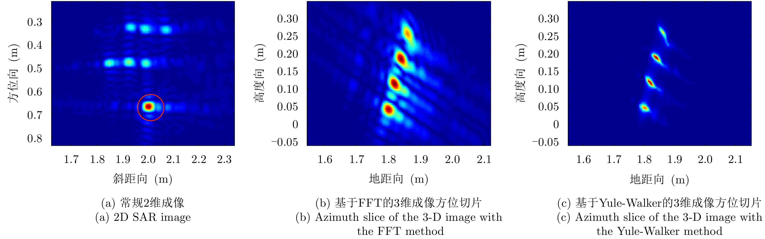
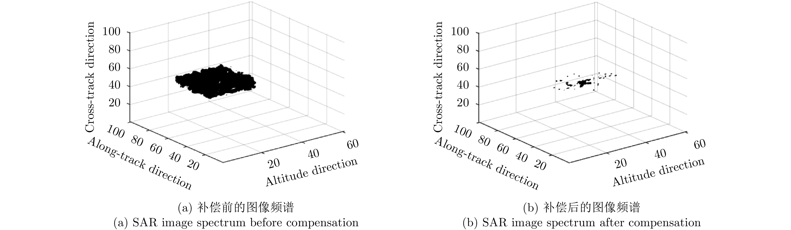
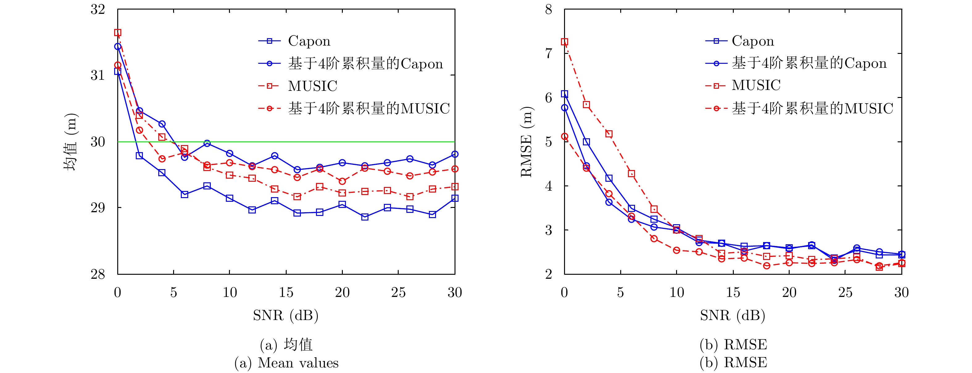
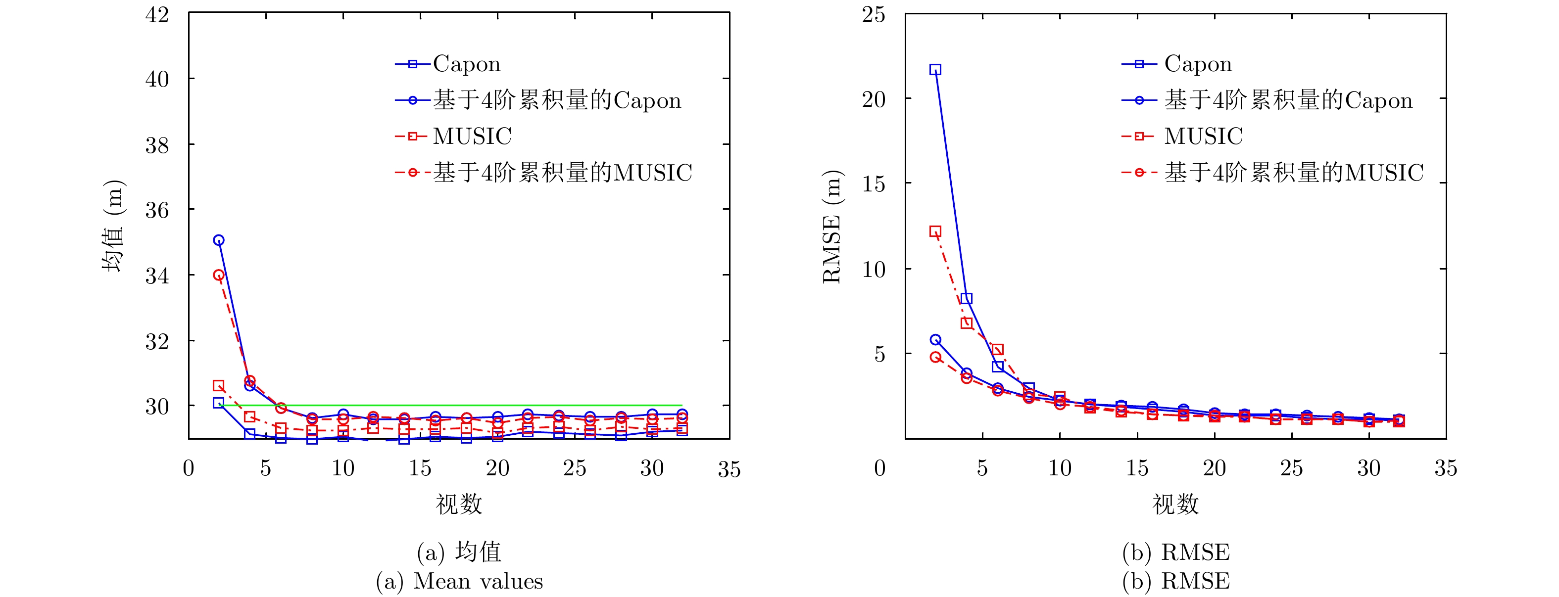
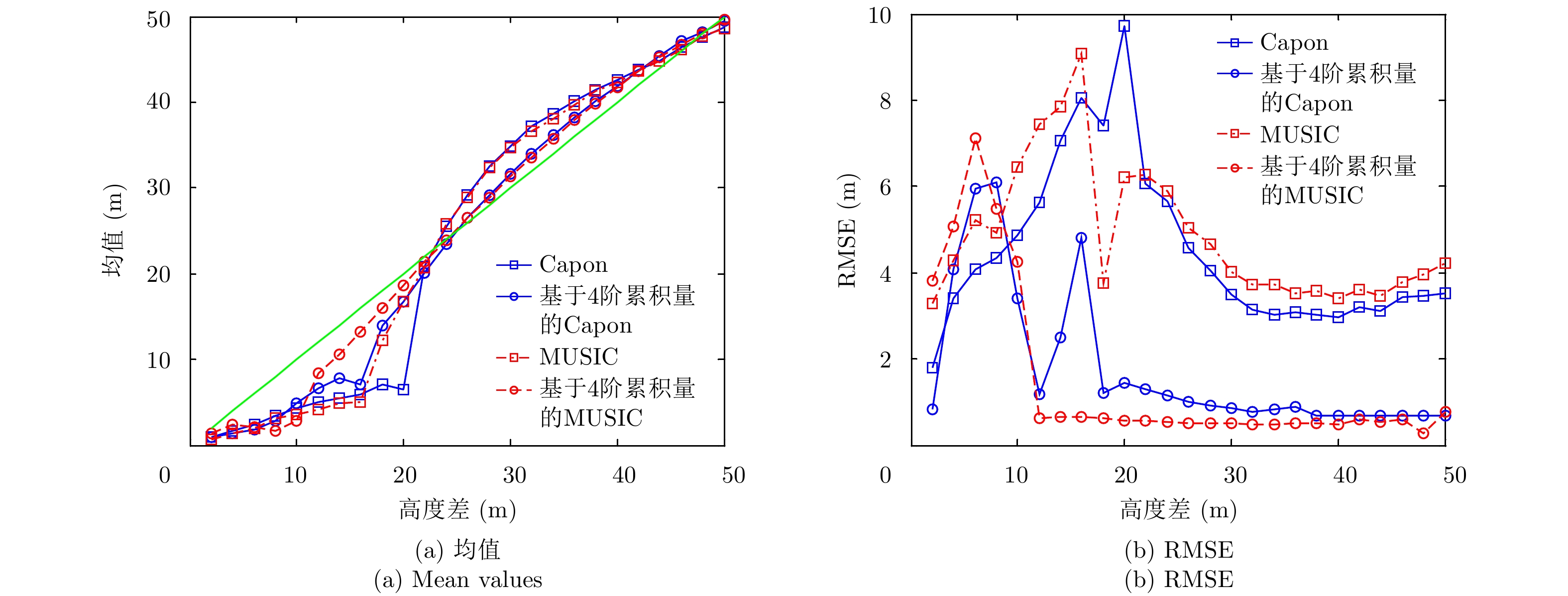
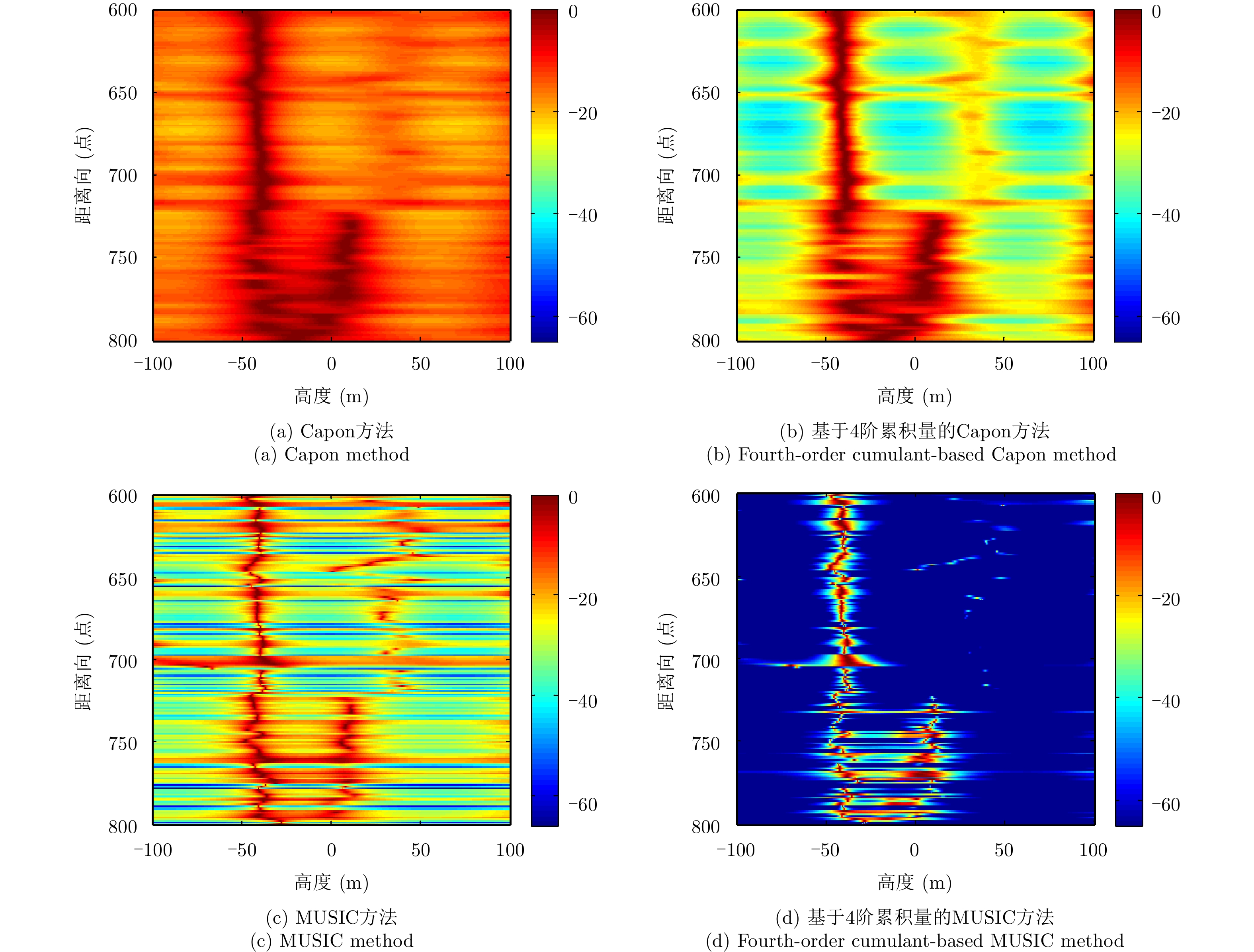
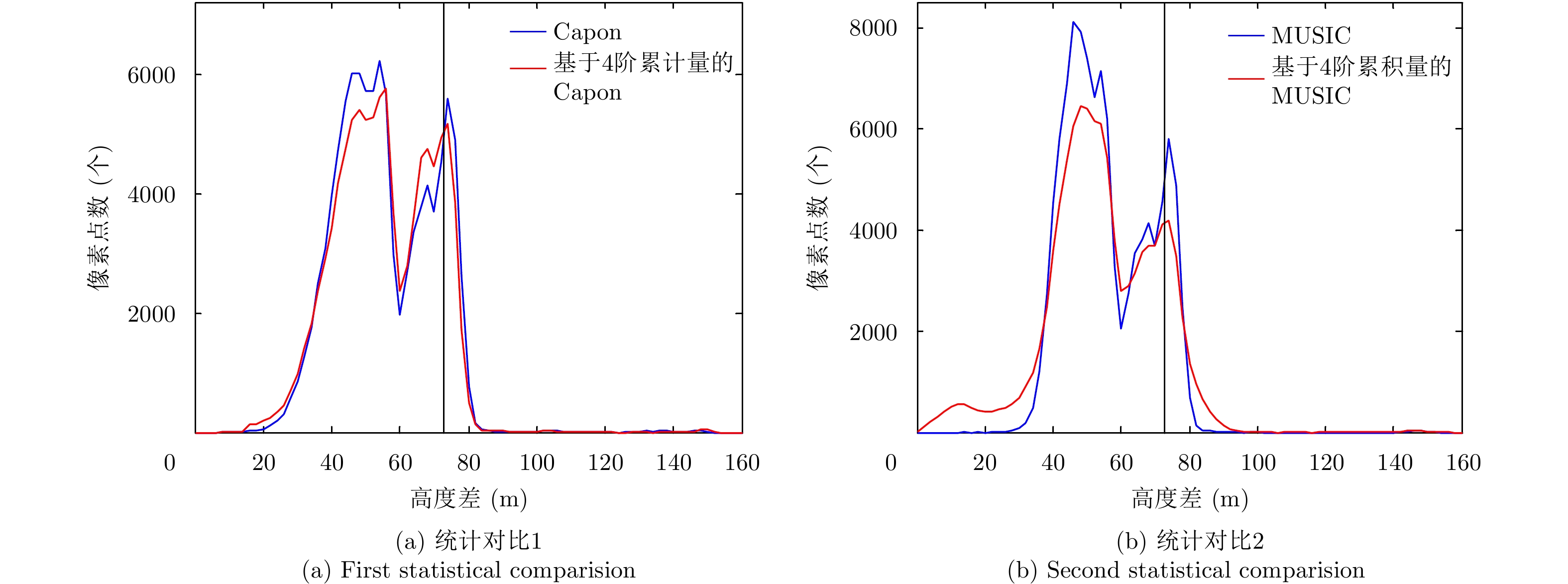
Layover is a difficult problem in SAR imaging technology. Airborne multi-baseline SAR systems are constrained by non-uniform baselines that are also few in number, which means the measured scattering point height is characterized by unacceptable error and poor resolution when using traditional spectrum estimation methods. To solve these problems, in this paper, we combine fourth-order cumulant statistical properties with traditional spectrum estimation methods. With its blind Gaussian noise characteristic, non-uniform virtual array extension of the fourth-order cumulant, and traditional Capon and MUSIC spectrum estimation approaches, the proposed method can effectively remove the Gaussian noise, while also improving the measurement accuracy and resolution of the scattering point heights. The simulation and real-data experimental results validate the effectiveness of our proposal.
Layover is a difficult problem in SAR imaging technology. Airborne multi-baseline SAR systems are constrained by non-uniform baselines that are also few in number, which means the measured scattering point height is characterized by unacceptable error and poor resolution when using traditional spectrum estimation methods. To solve these problems, in this paper, we combine fourth-order cumulant statistical properties with traditional spectrum estimation methods. With its blind Gaussian noise characteristic, non-uniform virtual array extension of the fourth-order cumulant, and traditional Capon and MUSIC spectrum estimation approaches, the proposed method can effectively remove the Gaussian noise, while also improving the measurement accuracy and resolution of the scattering point heights. The simulation and real-data experimental results validate the effectiveness of our proposal.


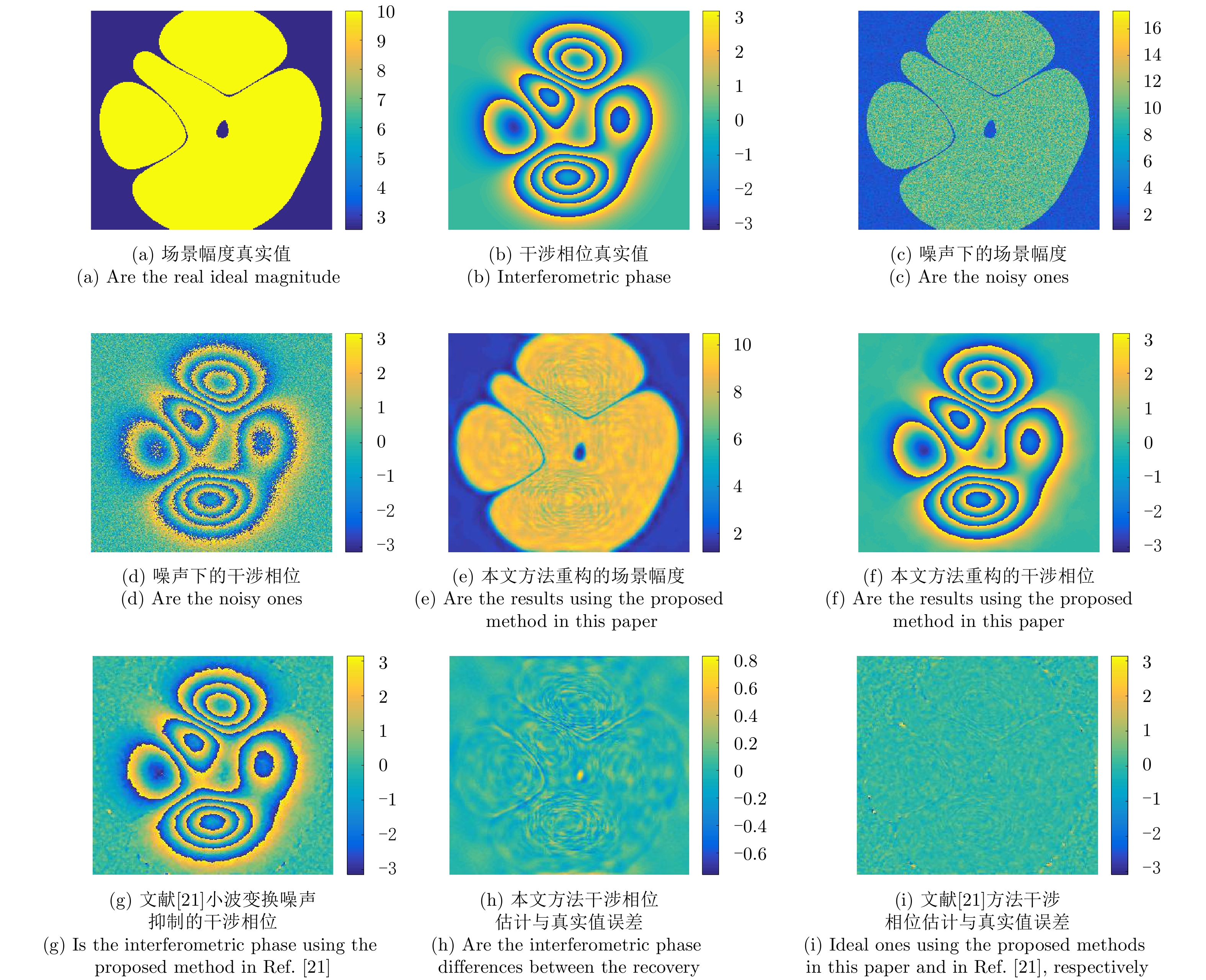
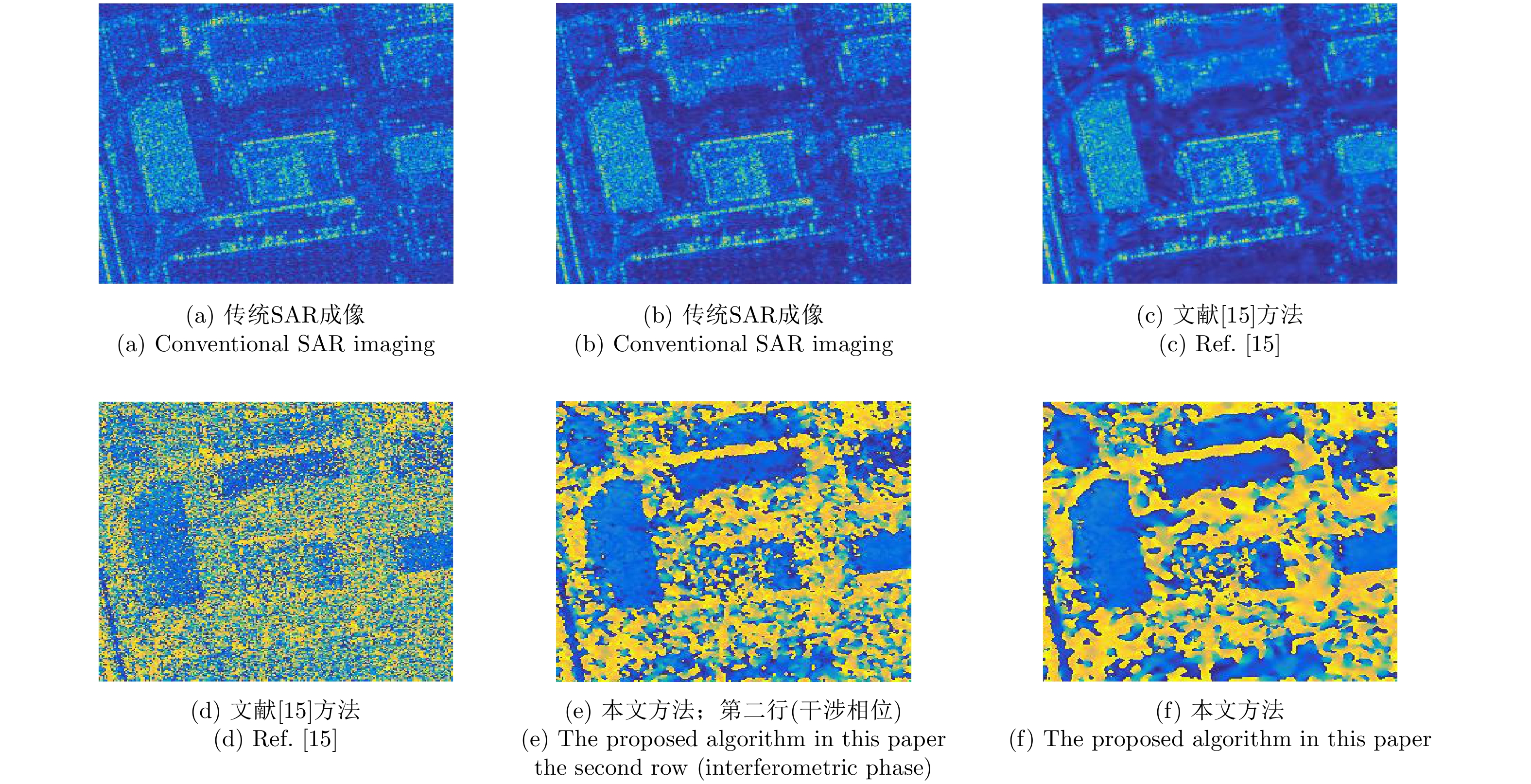
2018, 7(6): 750-757.
A novel sparse Bayesian learning approach with a joint sparsity model is proposed for Interferometric Synthetic Aperture Radar (InSAR) image formation to realize the feature enhancements of interferometric phase denoising and speckle reduction. Using Bayesian rules, sparse image formation is achieved using a hierarchical statistical model. In particular, structured sparsity with joint channels is imposed on the InSAR images. During sparse imaging, an Expectation-Maximization (EM) method is employed for image formation and hyper-parameter estimation. Using joint sparsity statistics, the performance of the noise reduction on the magnitude and phase of InSAR images can be improved. Finally, experimental analysis is performed using simulated and measured data to confirm the effectiveness of the proposed algorithm.
A novel sparse Bayesian learning approach with a joint sparsity model is proposed for Interferometric Synthetic Aperture Radar (InSAR) image formation to realize the feature enhancements of interferometric phase denoising and speckle reduction. Using Bayesian rules, sparse image formation is achieved using a hierarchical statistical model. In particular, structured sparsity with joint channels is imposed on the InSAR images. During sparse imaging, an Expectation-Maximization (EM) method is employed for image formation and hyper-parameter estimation. Using joint sparsity statistics, the performance of the noise reduction on the magnitude and phase of InSAR images can be improved. Finally, experimental analysis is performed using simulated and measured data to confirm the effectiveness of the proposed algorithm.


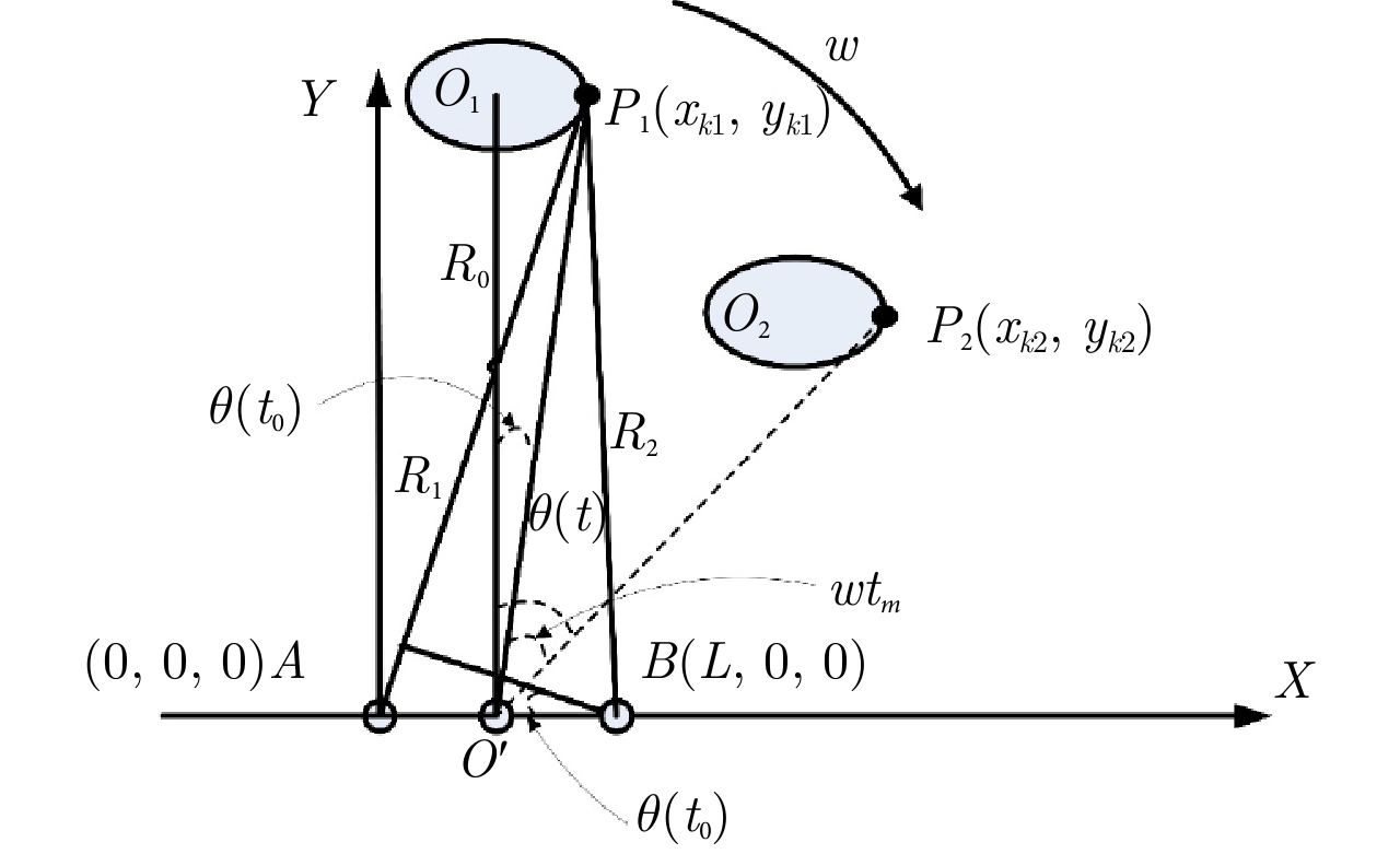
2018, 7(6): 758-769.
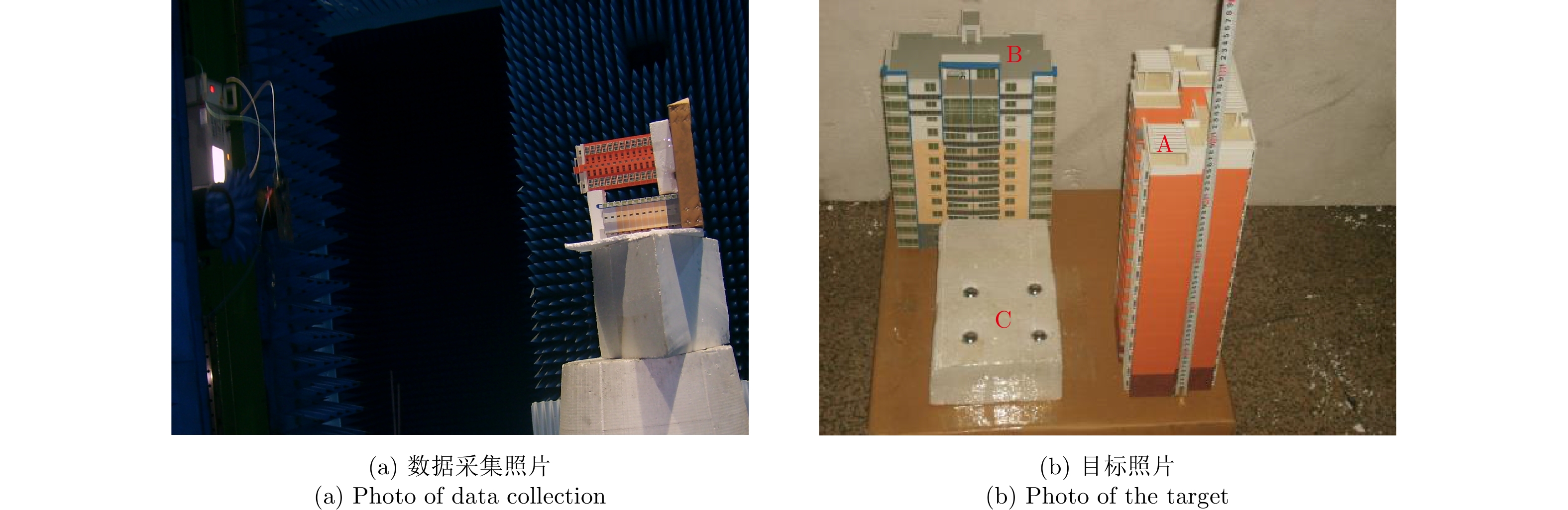
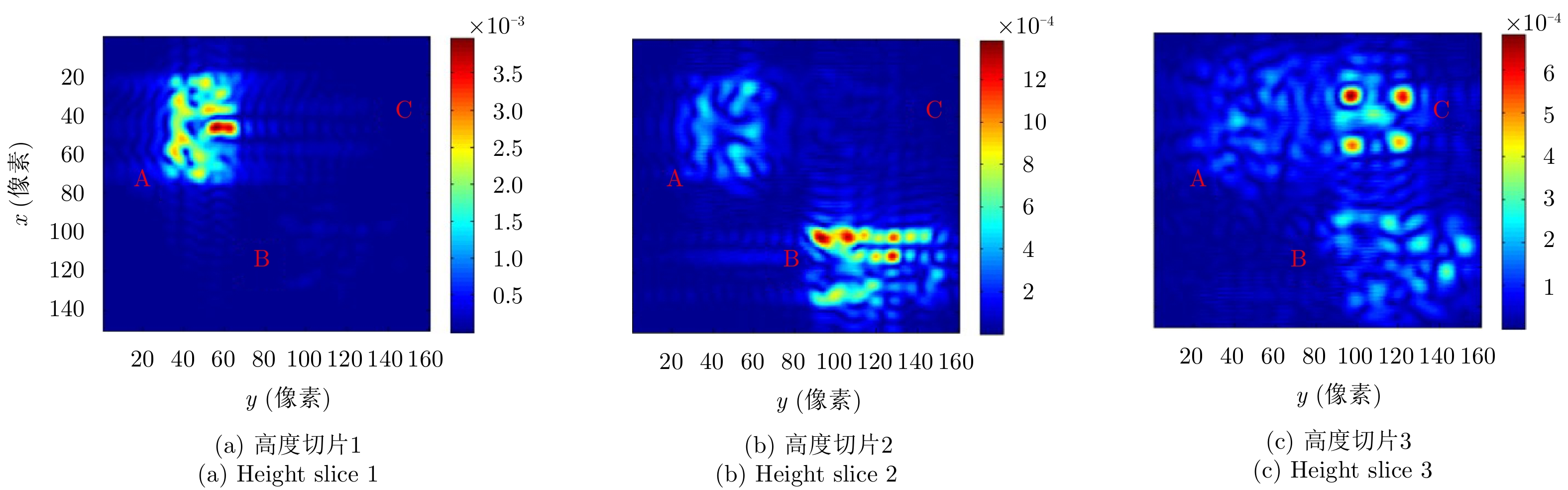
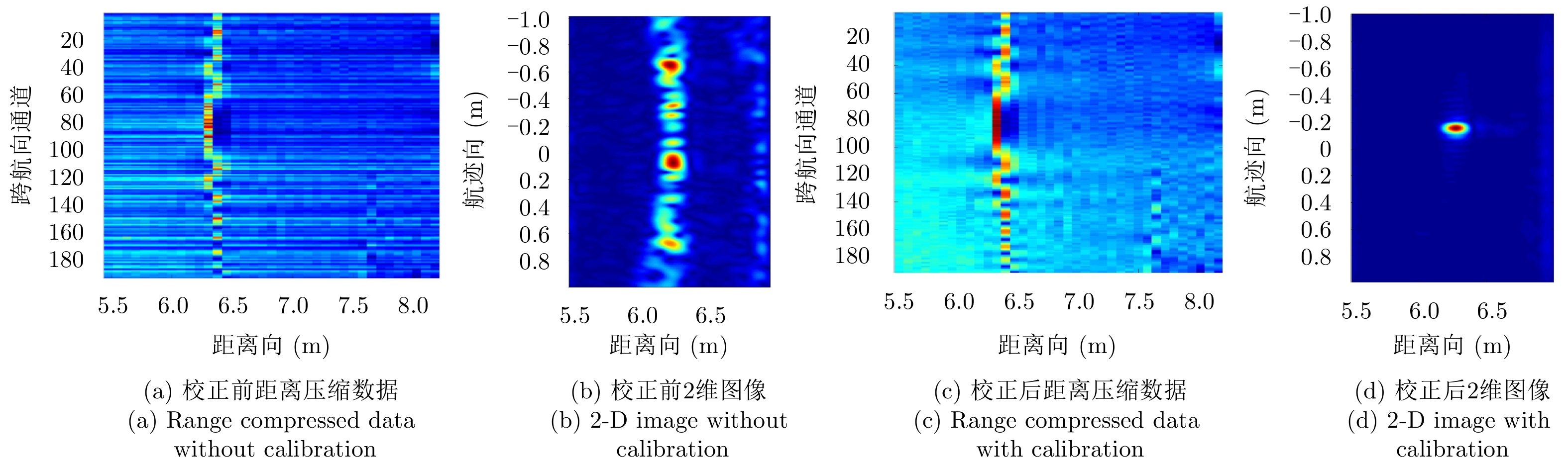
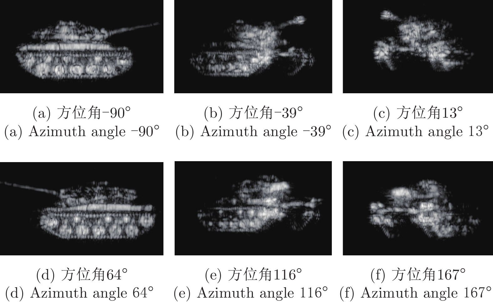
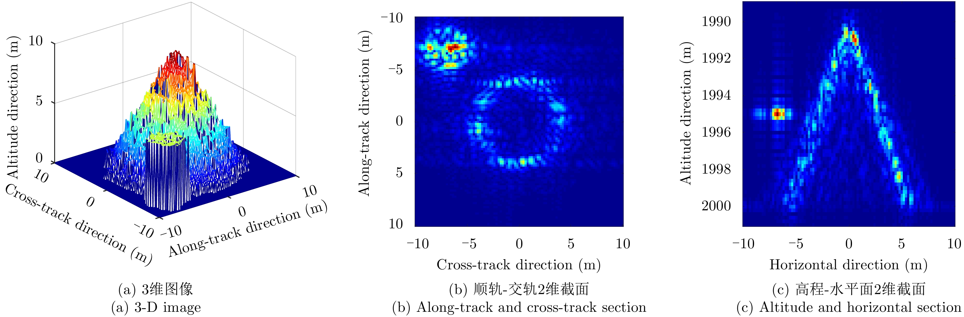
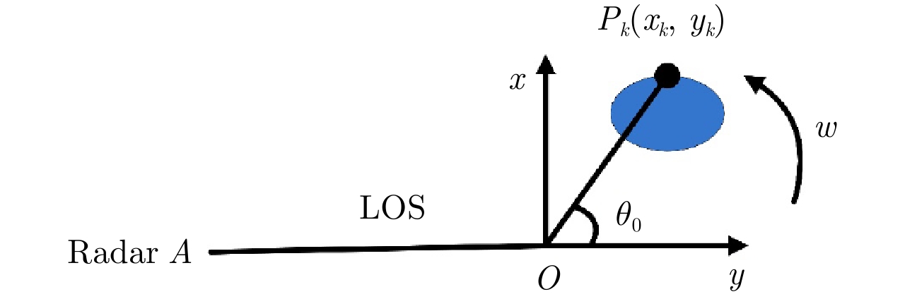
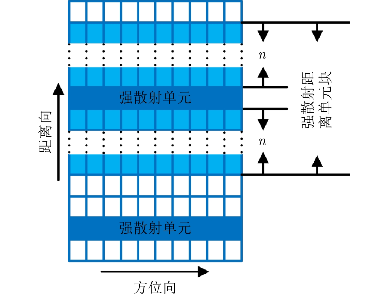
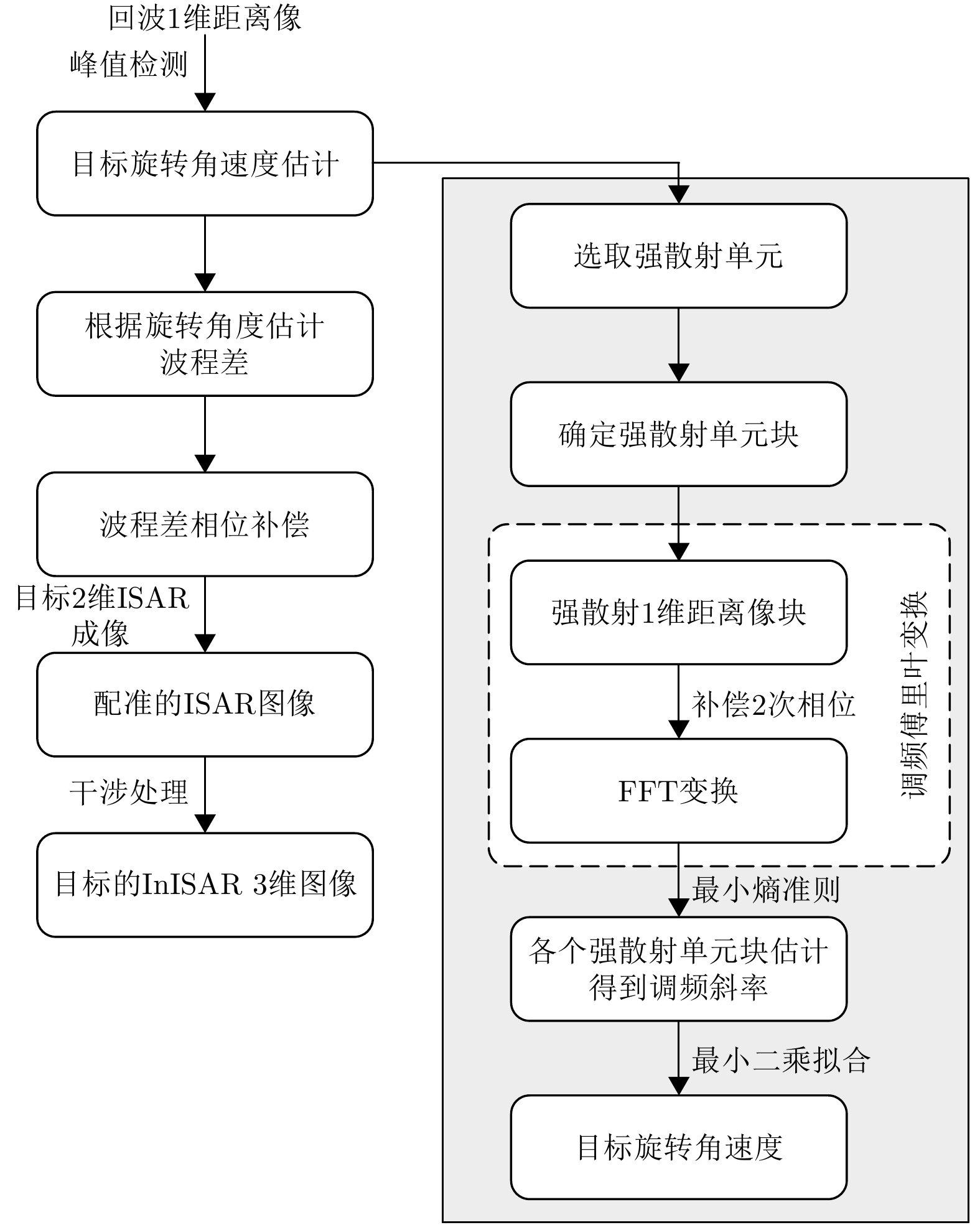
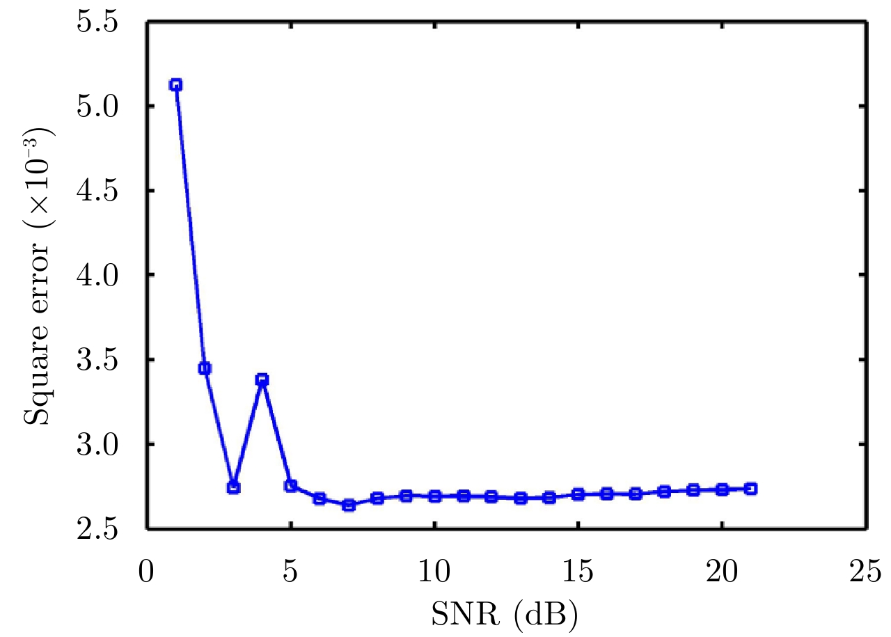
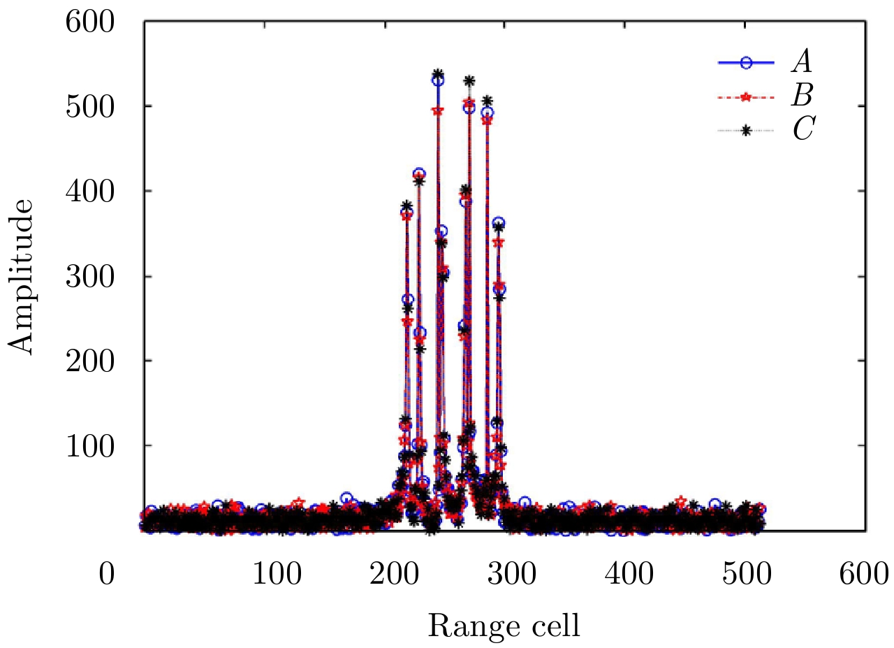
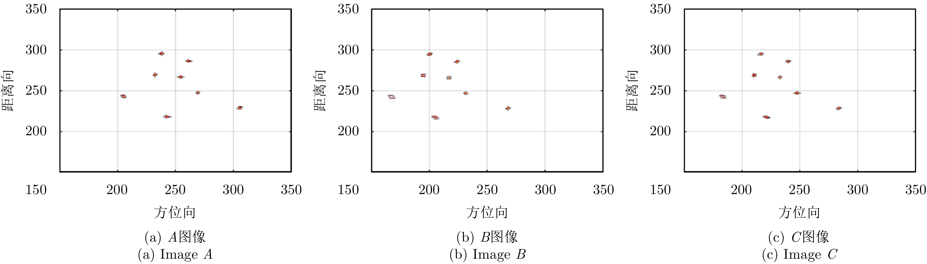
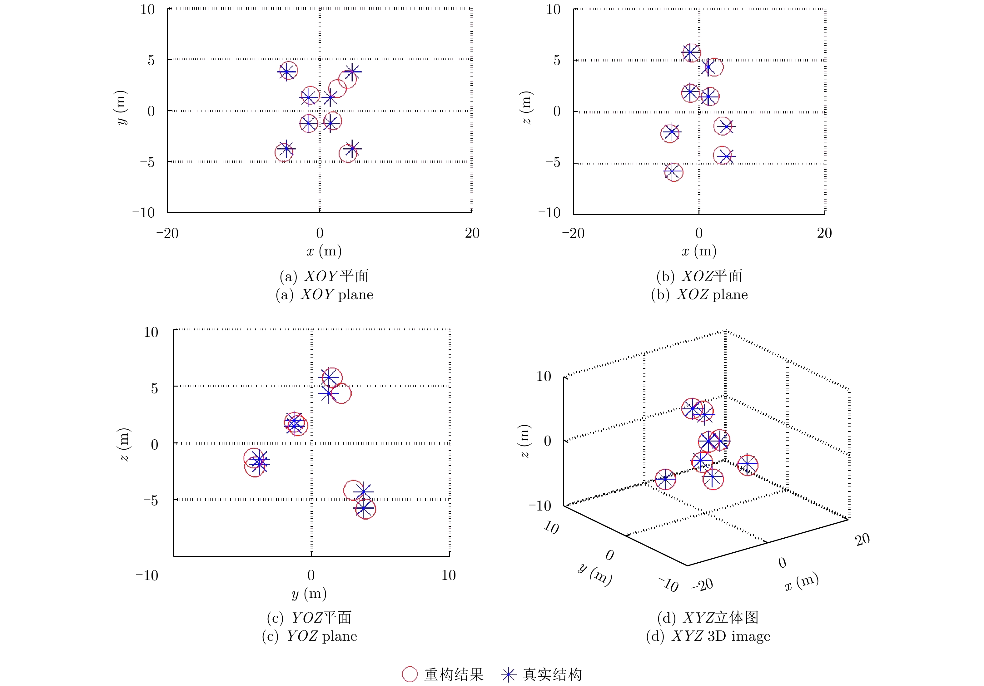
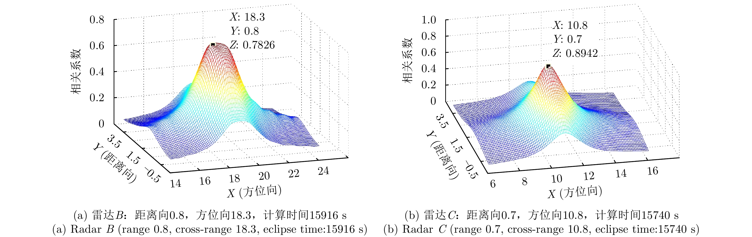
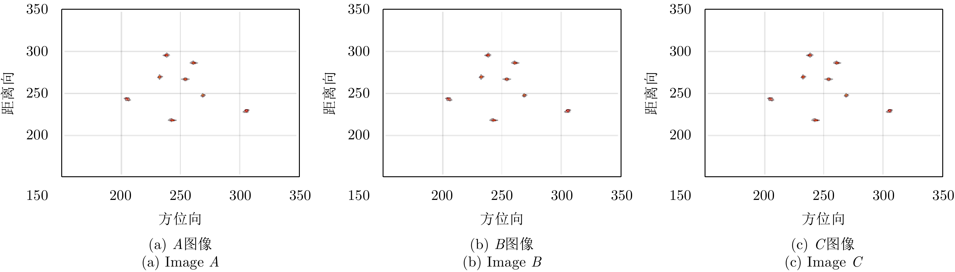
In Interferometric Inverse Synthetic Aperture Radar (InISAR) three-Dimensional (3D) imaging, Inverse Synthetic Aperture Radar (ISAR) image registration is a key process. It arranges similar scatterers in different ISAR images on the same pixel cell, which completes the interferometric processing for similar scatterers to obtain their 3D coordinates. This paper analyses the ISAR image mismatch caused by the difference of the wave path between the scatterer and different radars and then proposes a new ISAR image registration method that consists of three steps, based on wave path difference compensation. First, chirp Fourier transform is used to estimate the rotational angular velocity of the target. Second, the compensation phase is constructed according to the rotational angular velocity to eliminate the wave path difference between scatterer and different radars. Finally, two-Dimensional (2D) Fourier transform can yield ISAR images without mismatch. The proposed method can directly achieve ISAR image registration in an echo field. After image registration based on this method, the scatterers match-up well. But after image registration based on the correlation method, the scatterers have a mismatch of about one pixel cell. Compared to the correlation method, this method can achieve image registration more efficiently. Finally, the 3D imaging error (0.3034) based on this method is smaller than that (45.8529) of the correlation method.
In Interferometric Inverse Synthetic Aperture Radar (InISAR) three-Dimensional (3D) imaging, Inverse Synthetic Aperture Radar (ISAR) image registration is a key process. It arranges similar scatterers in different ISAR images on the same pixel cell, which completes the interferometric processing for similar scatterers to obtain their 3D coordinates. This paper analyses the ISAR image mismatch caused by the difference of the wave path between the scatterer and different radars and then proposes a new ISAR image registration method that consists of three steps, based on wave path difference compensation. First, chirp Fourier transform is used to estimate the rotational angular velocity of the target. Second, the compensation phase is constructed according to the rotational angular velocity to eliminate the wave path difference between scatterer and different radars. Finally, two-Dimensional (2D) Fourier transform can yield ISAR images without mismatch. The proposed method can directly achieve ISAR image registration in an echo field. After image registration based on this method, the scatterers match-up well. But after image registration based on the correlation method, the scatterers have a mismatch of about one pixel cell. Compared to the correlation method, this method can achieve image registration more efficiently. Finally, the 3D imaging error (0.3034) based on this method is smaller than that (45.8529) of the correlation method.


2018, 7(6): 770-776.
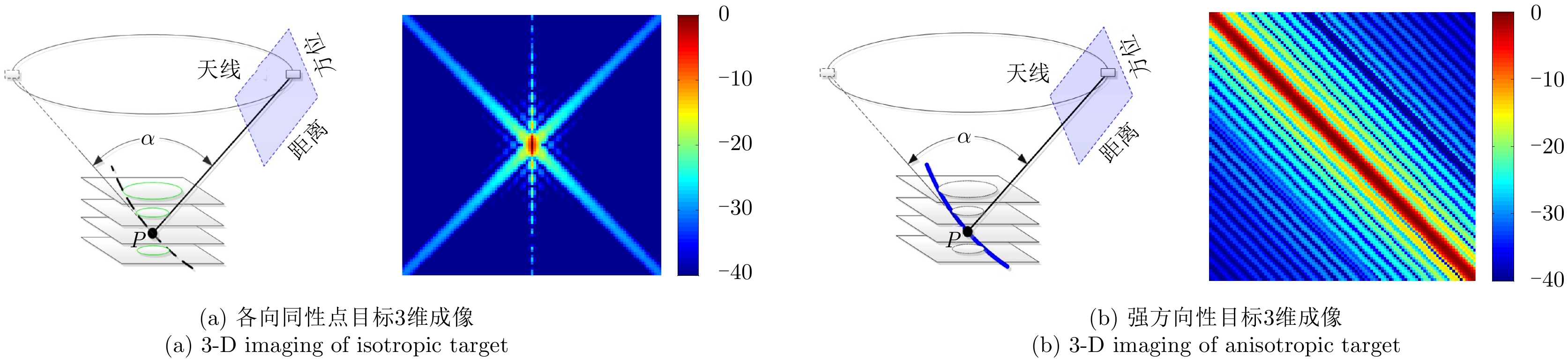
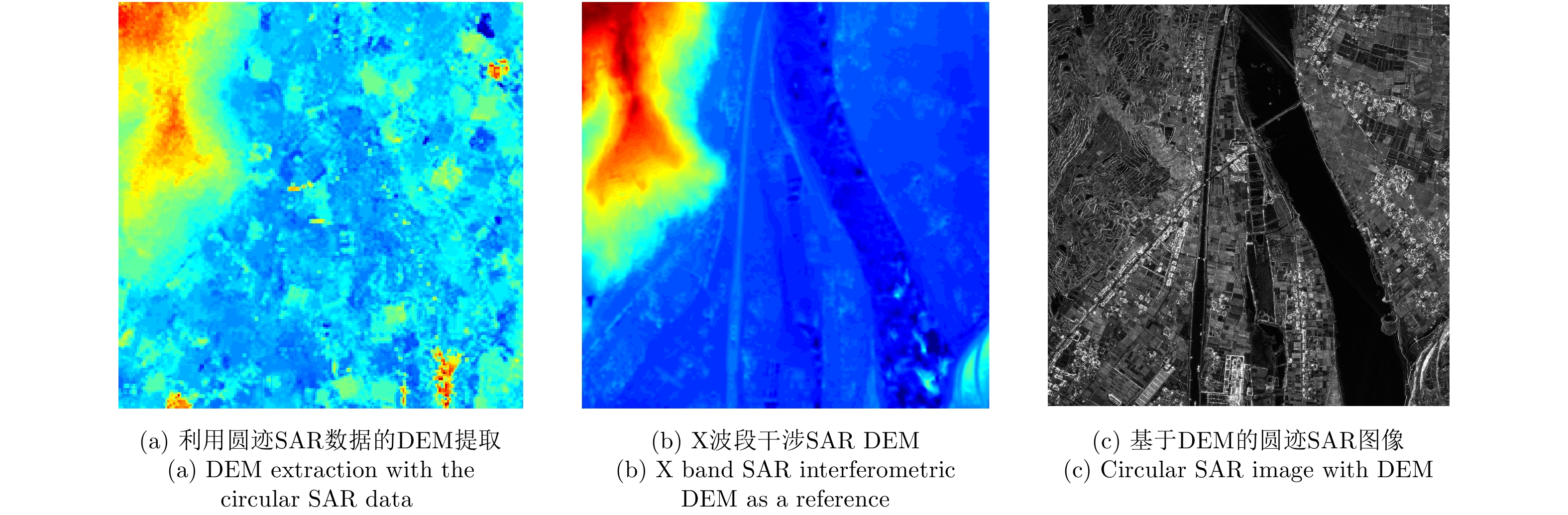
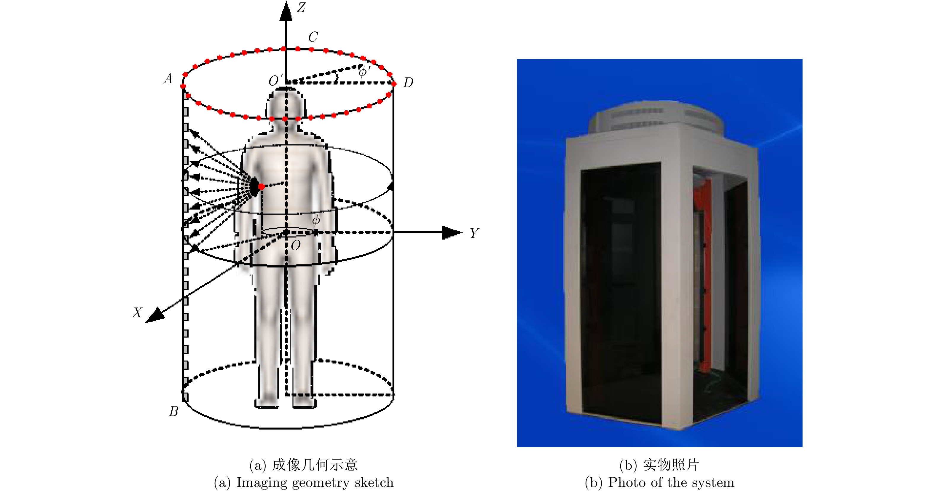
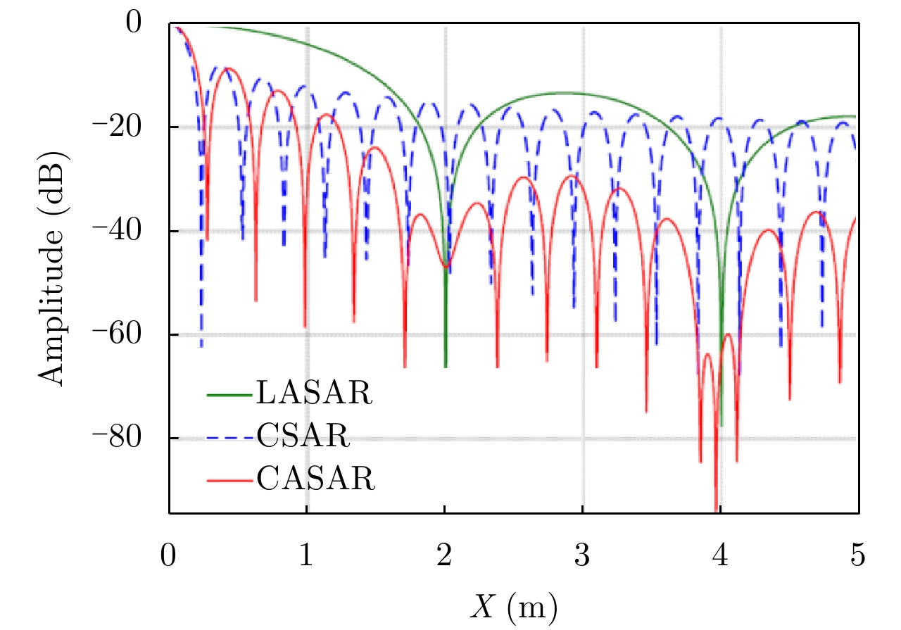
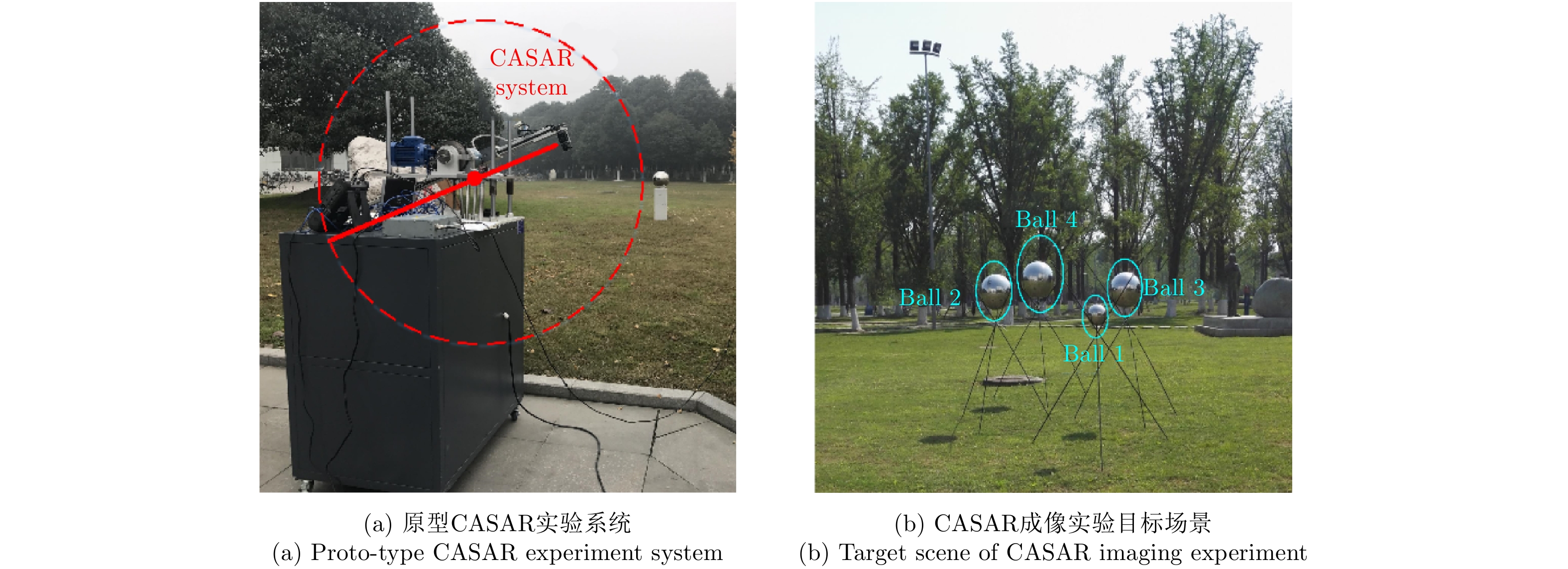
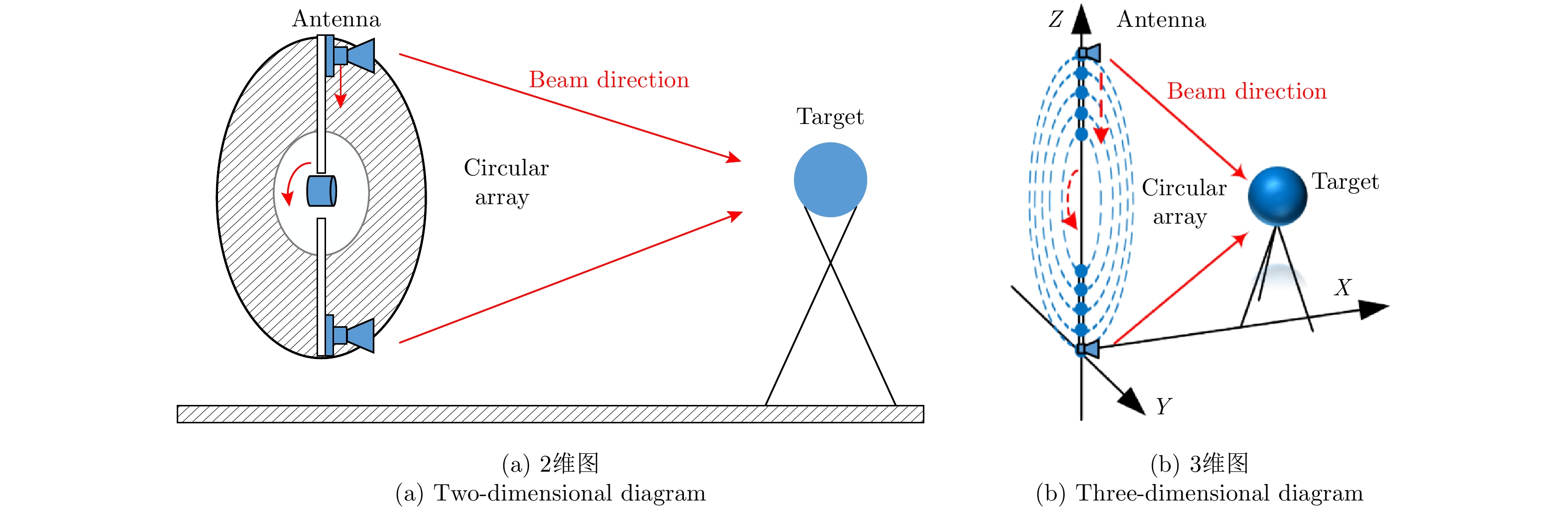
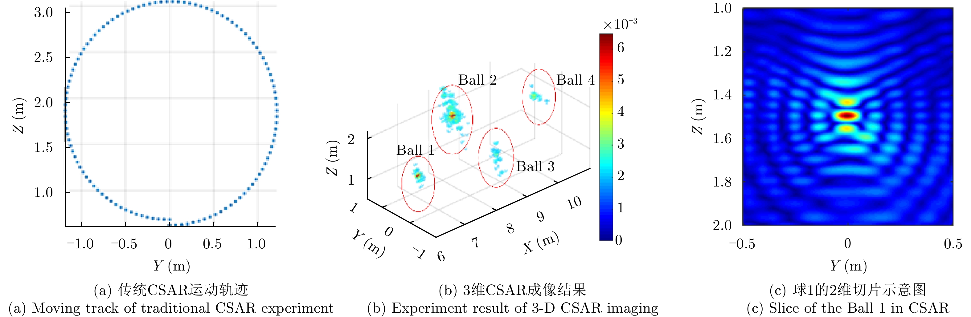
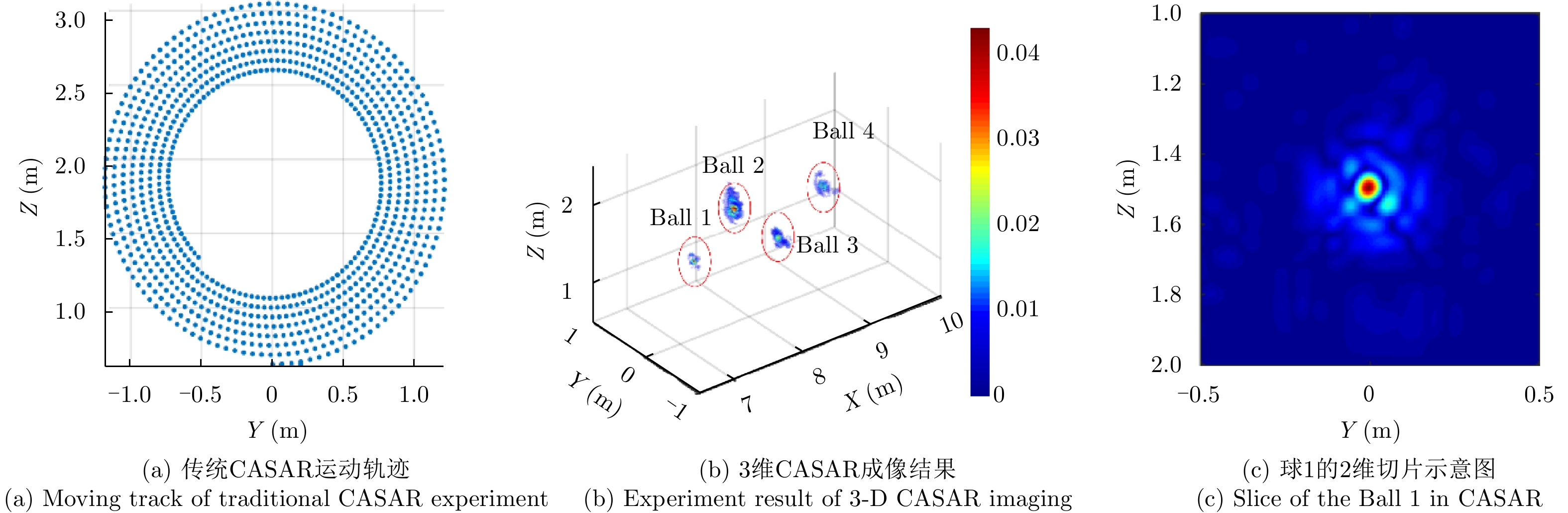
Array Synthetic Aperture Radar (ASAR) system radar imaging field has gained attention because of its three-dimensional (3-D) imaging ability. A novel Circular Array SAR (CASAR) system is employed for 3-D high-resolution radar imaging to overcome the drawbacks exhibited by linear array SAR in high-resolution imaging and by circular SAR in side-lobe suppression. Point Spread Function (PSF) model based on the CASAR system is derived, and the advantages of the new configuration of the circular array in 3-D imaging are theoretically analyzed. Prototype CASAR experimental system is built on the basis of the abovementioned analysis. PSF simulation experiments and outdoor 3-D CASAR imaging experiments under outdoor conditions are performed to verify performance of the CASAR system in 3-D SAR imaging. Compared imaging results acquired using linear array SAR, circular SAR, and CASAR system proves that the CASAR system has high-resolution 3-D SAR images and demonstrates effective side-lobe suppression capability.
Array Synthetic Aperture Radar (ASAR) system radar imaging field has gained attention because of its three-dimensional (3-D) imaging ability. A novel Circular Array SAR (CASAR) system is employed for 3-D high-resolution radar imaging to overcome the drawbacks exhibited by linear array SAR in high-resolution imaging and by circular SAR in side-lobe suppression. Point Spread Function (PSF) model based on the CASAR system is derived, and the advantages of the new configuration of the circular array in 3-D imaging are theoretically analyzed. Prototype CASAR experimental system is built on the basis of the abovementioned analysis. PSF simulation experiments and outdoor 3-D CASAR imaging experiments under outdoor conditions are performed to verify performance of the CASAR system in 3-D SAR imaging. Compared imaging results acquired using linear array SAR, circular SAR, and CASAR system proves that the CASAR system has high-resolution 3-D SAR images and demonstrates effective side-lobe suppression capability.


 微信 | 公众平台

