
 Submit Manuscript
 Peer Review
 Editor Work
- Home
- Articles & Issues
-
Data
- Dataset of Radar Detecting Sea
- SAR Dataset
- SARGroundObjectsTypes
- SARMV3D
- AIRSAT Constellation SAR Land Cover Classification Dataset
- 3DRIED
- UWB-HA4D
- LLS-LFMCWR
- FAIR-CSAR
- MSAR
- SDD-SAR
- FUSAR
- SpaceborneSAR3Dimaging
- Sea-land Segmentation
- SAR Multi-domain Ship Detection Dataset
- SAR-Airport
- Hilly and mountainous farmland time-series SAR and ground quadrat dataset
- SAR images for interference detection and suppression
- HP-SAR Evaluation & Analytical Dataset
- GDHuiYan-ATRNet
- Multi-System Maritime Low Observable Target Dataset
- DatasetinthePaper
- DatasetintheCompetition
- Report
- Course
- About
- Publish
- Editorial Board
- Chinese
| Citation: | Zhou Chaowei, Li Zhenfang, Wang Yuekun, Xie Jinwei. Space-borne SAR Three-dimensional Imaging by Joint Multiple Azimuth Angle Doppler Frequency Rate Estimation[J]. Journal of Radars, 2018, 7(6): 696-704. doi: 10.12000/JR18094

|
Space-borne SAR Three-dimensional Imaging by Joint Multiple Azimuth Angle Doppler Frequency Rate Estimation
DOI: 10.12000/JR18094 CSTR: 32380.14.JR18094
-
Abstract
Using azimuth beam steering, space-borne Synthetic Aperture Radar (SAR) can observe from multiple azimuth angle in single pass. During multiple azimuth angle observation, the satellite orbit is equivalent to long three-dimensional (3-D) curvilinear array, which has the potential for 3-D imaging. Sampling by space-borne multiple azimuth angle SAR is sparse in height dimension, which makes unambiguous 3-D imaging by 3-D fast Fourier transform infeasible. Besides, the complex relationship between the targets’ projection in multi-angle SAR images and the height error is difficult to determine. To overcome this limitation, in this paper, we present a 3-D imaging method based on joint multiple azimuth angle Doppler frequency rate estimation. First, a relationship is proposed between the height error and Doppler frequency rate at different azimuth angle. Then, the Doppler frequency modulation rate error is estimated by Map Drift (MD) technique. Next, the height estimation results of different azimuth angle are combined to improve the estimation accuracy. From the estimated height and the target location in the SAR images, 3-D geometric information is retrieved and 3-D imaging is achieved. Our simulation experiments validate that the height estimation can achieve an accuracy of few meters with the proposed method. -

-
References
[1] 杨汝良, 李海英, 李世强, 等. 高分辨率微波成像[M]. 北京: 国防工业出版社, 2013: VII–IX.Yang Ru-liang, Li Hai-ying, Li Shi-qiang, et al.. High Resolution Microwave Imaging[M]. Beijing: National Defense Industry Press, 2013: VII–IX.[2] 侯建国, 张勤, 杨成生. InSAR技术及其在地质灾害中的应用[J]. 测绘与空间地理信息, 2007, 30(6): 28–30, 35. DOI: 10.3969/j.issn.1672-5867.2007.06.008Hou Jian-guo, Zhang Qin, and Yang Cheng-sheng. Introduction to InSAR and its applications in geohazards[J]. Geomatics&Spatial Information Technology, 2007, 30(6): 28–30, 35. DOI: 10.3969/j.issn.1672-5867.2007.06.008[3] Krieger G, Hajnsek I, Younis M, et al. Interferometric synthetic aperture radar (SAR) missions employing formation flying[J]. Proceedings of the IEEE, 2010, 98(5): 816–843. DOI: 10.1109/JPROC.2009.2038948[4] Reigber A and Moreira A. First demonstration of airborne SAR tomography using multibaseline L-band data[J]. IEEE Transactions on Geoscience and Remote Sensing, 2000, 38(5): 2142–2152. DOI: 10.1109/36.868873[5] Poncos V. On the use of TerraSAR-X and Radarsat-2 spotlight data for persistent scatterers and tomographic analysis[C]. Proceedings of IEEE International Geoscience and Remote Sensing Symposium, Munich, Germany, 2012.[6] 周汉飞, 李禹, 粟毅. 利用多角度SAR数据实现三维成像[J]. 电子与信息学报, 2013, 35(10): 2467–2474. DOI: 10.3724/SP.J.1146.2012.01534Zhou Han-fei, Li Yu, and Su Yi. Three-dimensional imaging with multi-aspect SAR data[J]. Journal of Electronics&Information Technology, 2013, 35(10): 2467–2474. DOI: 10.3724/SP.J.1146.2012.01534[7] 周汉飞, 李禹, 粟毅. 基于压缩感知的多角度SAR特征提取[J]. 电子学报, 2013, 41(3): 543–548. DOI: 10.3969/j.issn.0372-2112.2013.03.021Zhou Han-fei, Li Yu, and Su Yi. Multi-aspect SAR feature extraction based on compressive sensing[J]. Acta Electronica Sinica, 2013, 41(3): 543–548. DOI: 10.3969/j.issn.0372-2112.2013.03.021[8] 洪文. 圆迹SAR成像技术研究进展[J]. 雷达学报, 2012, 1(2): 124–135. DOI: 10.3724/SP.J.1300.2012.20046Hong Wen. Progress in circular SAR imaging technique[J]. Journal of Radars, 2012, 1(2): 124–135. DOI: 10.3724/SP.J.1300.2012.20046[9] Ertin E, Austin C D, Sharma S, et al.. GOTCHA experience report: Three-dimensional SAR imaging with complete circular apertures[C]. Proceedings of SPIE 6568, Algorithms for Synthetic Aperture Radar Imagery XIV, Orlando, United States, 2007: 656802. DOI: 10.1117/12.723245.[10] Knaell K. Three-dimensional SAR from curvilinear apertures[C]. Proceedings of the 1996 IEEE National Radar Conference, Ann Arbor, USA, 1996: 220–225. DOI: 10.1109/NRC.1996.510684.[11] 何峰, 杨阳, 董臻, 等. 曲线合成孔径雷达三维成像研究进展与展望[J]. 雷达学报, 2015, 4(2): 130–135. DOI: 10.12000/JR14119He Feng, Yang Yang, Dong Zhen, et al. Progress and prospects of curvilinear SAR 3-D imaging[J]. Journal of Radars, 2015, 4(2): 130–135. DOI: 10.12000/JR14119[12] Ferrara M, Jackson J A, and Austin C. Enhancement of multi-pass 3D circular SAR images using sparse reconstruction techniques[C]. Proceedings of SPIE 7337, Algorithms for Synthetic Aperture Radar Imagery XVI, Orlando, Florida, United States, 2009: 733702. DOI: 10.1117/12.820256.[13] Zhang J Q, Suo Z Y, Li Z F, et al. DEM Generation using circular SAR data based on low-rank and sparse matrix decomposition[J]. IEEE Geoscience and Remote Sensing Letters, 2018, 15(5): 724–728. DOI: 10.1109/LGRS.2018.2809905[14] Chen L P, An D X, Huang X T, et al. A 3D reconstruction strategy of vehicle outline based on single-pass single-polarization CSAR data[J]. IEEE Transactions on Image Processing, 2017, 26(11): 5545–5554. DOI: 10.1109/TIP.2017.2738566[15] Dungan K E and Potter L C. 3-D imaging of vehicles using wide aperture radar[J]. IEEE Transactions on Aerospace and Electronic Systems, 2011, 47(1): 187–200. DOI: 10.1109/TAES.2011.5705669[16] Duque S, Breit H, Balss U, et al. Absolute height estimation using a single TerraSAR-X staring spotlight acquisition[J]. IEEE Geoscience and Remote Sensing Letters, 2015, 12(8): 1735–1739. DOI: 10.1109/LGRS.2015.2422893[17] Curlander J C. Location of spaceborne SAR imagery[J]. IEEE Transactions on Geoscience and Remote Sensing, 1982, GE-20(3): 359–364. DOI: 10.1109/TGRS.1982.350455[18] Ferretti A, Monti-Guarnieri A, Prati C, et al.. InSAR Principles - Guidelines for SAR Interferometry Processing and Interpretation[M]. The Netherlands: ESA Publications, 2007.[19] Cumming I G, Wong F H, 洪文, 胡东辉. 合成孔径雷达成像: 算法与实现[M]. 北京: 电子工业出版社, 2012: 385–389.Cumming I G, Wong F H, Hong Wen, Hu Dong-hui. Digital Processing of Synthetic Aperture Radar Data: Algorithms and Implementation[M]. Beijing: Publishing House of Electronics Industry, 2012: 385–389.[20] Menon K R, Balakrishnan N, Janakiraman M, et al. Characterization of fluctuation statistics of radar clutter for Indian terrain[J]. IEEE Transactions on Geoscience and Remote Sensing, 1995, 33(2): 317–324. DOI: 10.1109/36.377931 -
Proportional views

- Publishing Ethics
- Journal Insights
- Abstracting & Indexing
- Peer Review Policies
- Guide for Authors
- Conference
- ISSN 2095-283X (Print)ISSN 2097-339X (Online)
- CN 10-1030/TN
- CODEN LXEUAO
About Journal
- Sponsor: China Radio Detection and Ranging Industry Association (CRIA)
- Phone: 010-58887062
- Email:radars@aircas.ac.cn
- Publisher: Leida Xuebao Bianjibu (Editorial office of the Journal of Radars)
Contacts Us

京ICP备20021838号-14
Supported by: Beijing Renhe Information Technology Co. Ltd

Export File
Citation
Format
Content
 DownLoad:


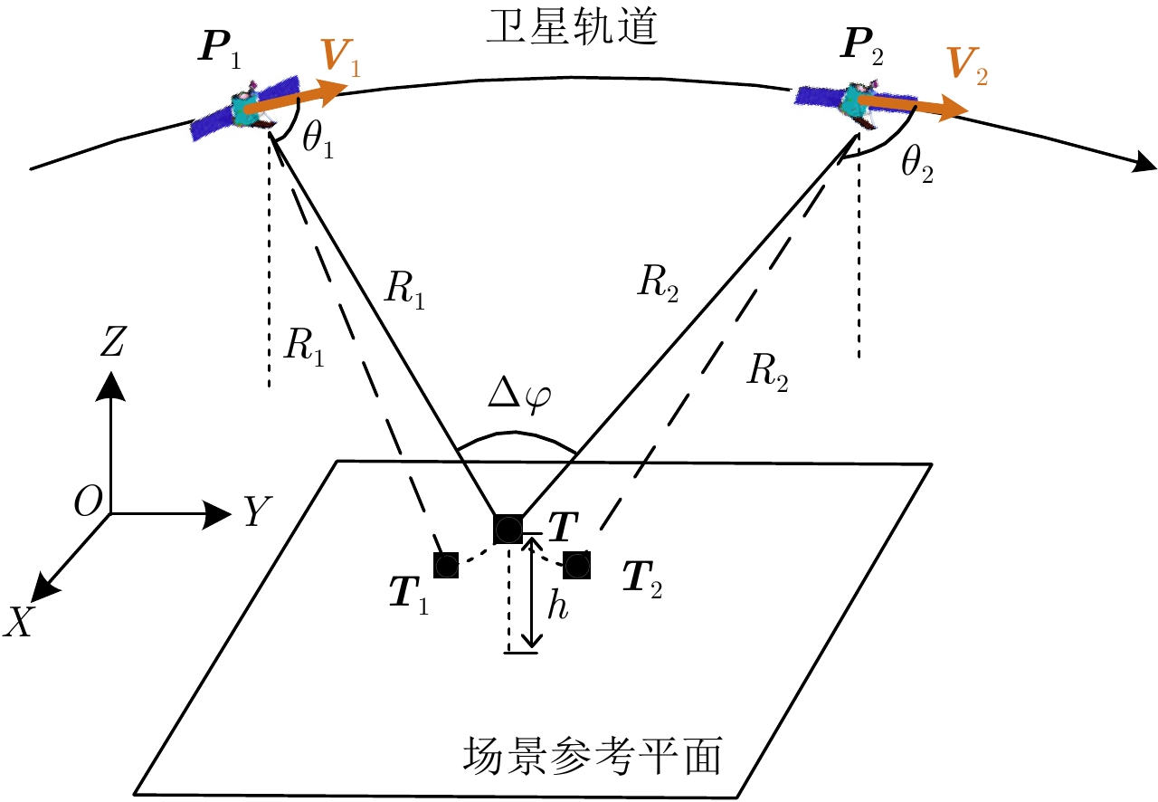
- Figure 1. Space-borne SAR multiple azimuth angle observation geometry
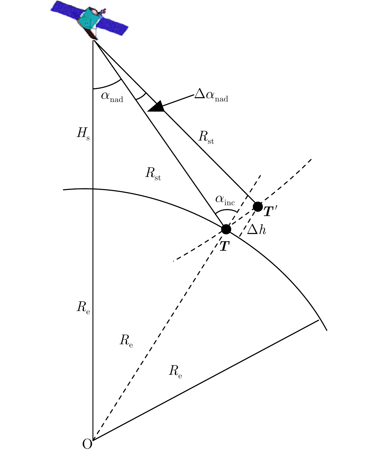
- Figure 2. The geometry of height error and nadir angle error
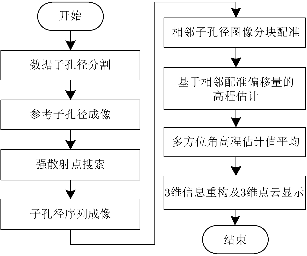
- Figure 4. The schematic diagram of space-borne SAR 3-D imaging method by multiple azimuth angle observation
- Figure 3. The relationship between Doppler frequency error and height in different nadir angles
- Figure 5. Height estimation RMSE in various signal noise ratio
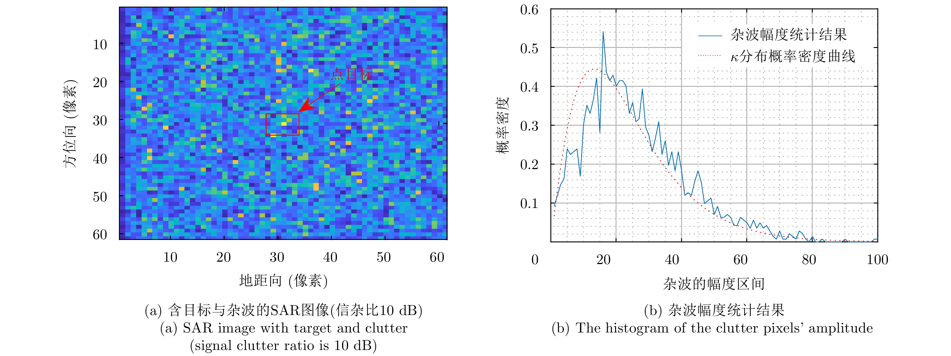
- Figure 6. Simulation result of clutter
- Figure 7. Monte Carlo height estimation record in various signal clutter ratio
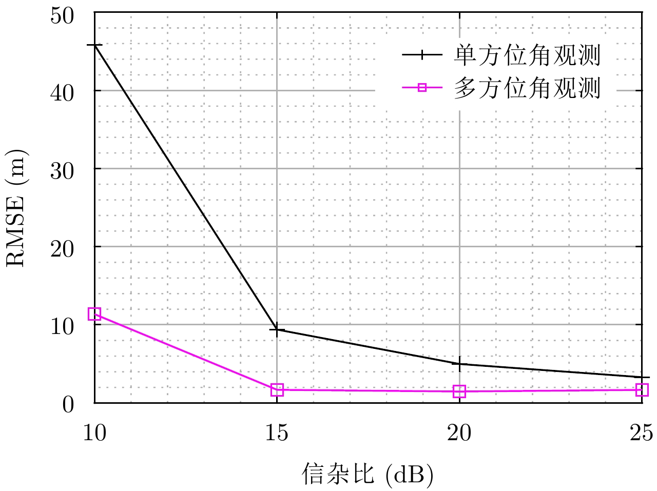
- Figure 8. Height estimation RMSE in various signal clutter ratio
- Figure 9. The model of cylider scatter array
- Figure 10.