
 作者中心
作者中心 专家审稿
专家审稿 责编办公
责编办公 编辑办公
编辑办公
Three-dimensional Imaging Algorithm for Multi-azimuth-angle Multi-baseline Spaceborne Synthetic Aperture Radar
-
摘要: 传统星载合成孔径雷达(Sythetic Aperture Radar, SAR)采用多基线的方式可获取目标区域的3维图像,解决了SAR 2维图像中的叠掩问题,但仍存在因遮挡导致的信息获取不足的问题。为此,该文首次提出了多方位角多基线星载SAR 3维成像方法,其不仅解决了叠掩问题,还通过融合不同方位角下获取的3维点云减少了遮挡区域,提升了星载SAR信息获取能力。文中首先建立多方位角多基线星载SAR空间观测模型,并通过推导论证斜视多基线观测和正侧视多基线观测具有相同的数学信号模型,为直接将正侧视时的3维成像方法应用于斜视时的3维处理提供理论支撑;在此基础上,给出多方位角多基线星载SAR 3维成像方法及处理流程,其包括SAR斜视3维处理和多方位角3维点云融合两个步骤;最后,通过方位角45°下的点阵目标实验验证SAR斜视3维处理方法的有效性,并利用方位角45°和–45°下的直升机目标仿真验证多方位角3维点云融合方法的有效性。Abstract: Traditional spaceborne Synthetic Aperture Radar (SAR) can acquire three-dimensional (3D) images by using multi-baseline SAR data, which solves the problem of layover in two-dimensional (2D) SAR image, however, there is still a problem of insufficient information acquisition caused by occlusion. Considering this, a 3D imaging algorithm for multi-azimuth-angle multi-baseline spaceborne SAR is proposed in this paper; this algorithm not only solves the problem of layover, but also reduces the occlusion area by fusing the 3D point clouds obtained under different azimuth angles and improves the information acquisition ability of spaceborne SAR. First, the observation model of multi-azimuth-angle multi-baseline spaceborne SAR is established, and it shows that the mathematical signal models of the multi-baseline SAR in the squint mode and broadside mode are the same, which provides theoretical support for the direct application of broadside 3D imaging algorithm to the 3D processing of squint mode. On this basis, the 3D imaging algorithm and processing flow of multi-azimuth-angle multi-baseline spaceborne SAR are presented. Finally, the effectivenesses of the squint 3D imaging method and 3D point clouds fusion method are verified by point targets simulation experiment with 45° azimuth angle and helicopter simulation experiments with 45° and –45° azimuth angles, respectively.
-
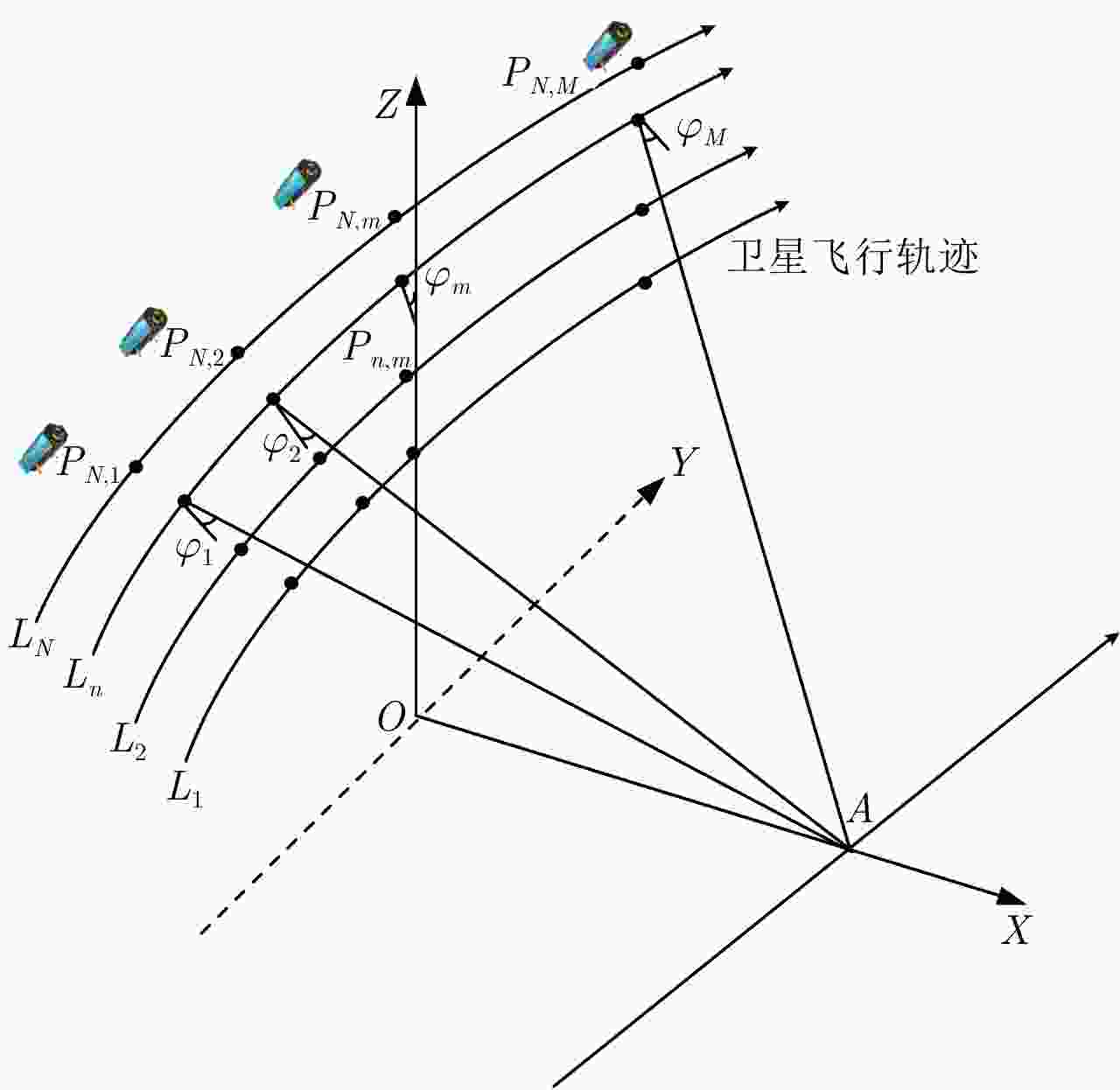
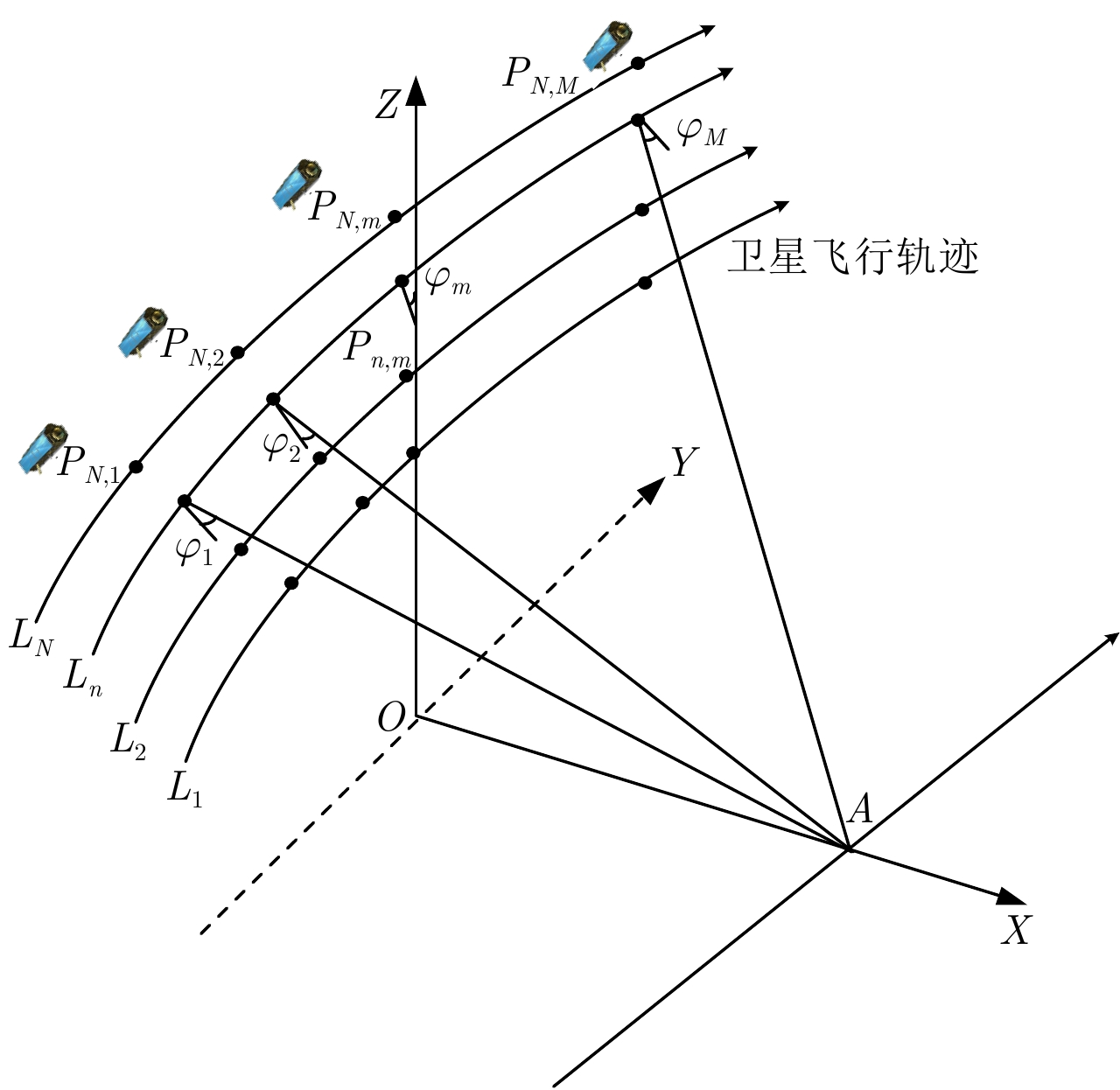
图 1 多方位角多基线星载SAR观测模型
Figure 1. Obsevation model of multi-azimuth-angle multi-baseline spaceborne SAR
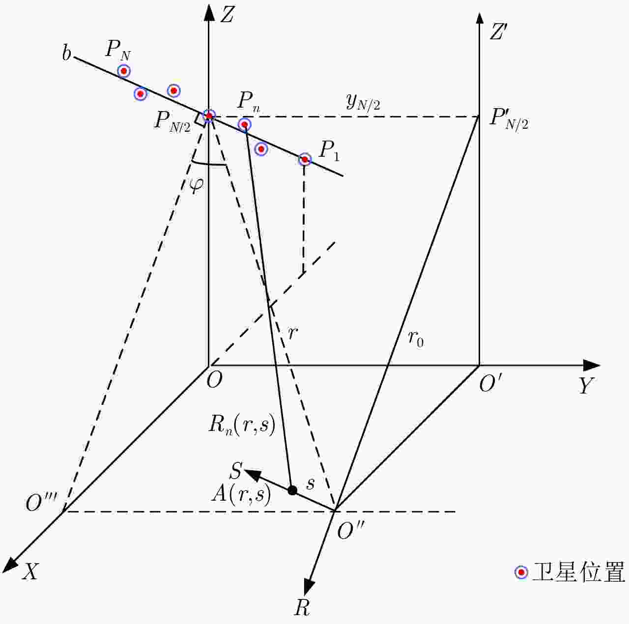
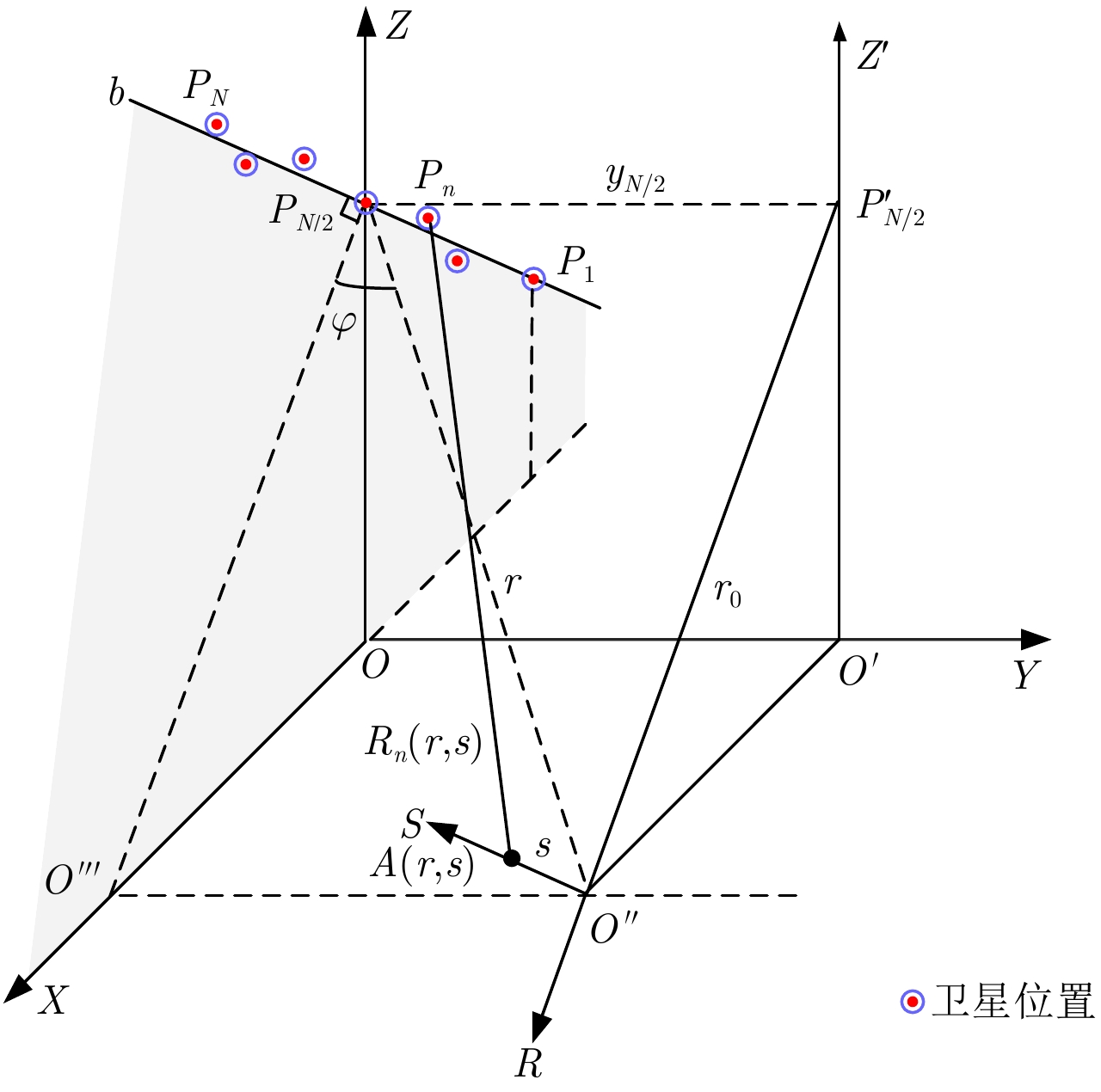
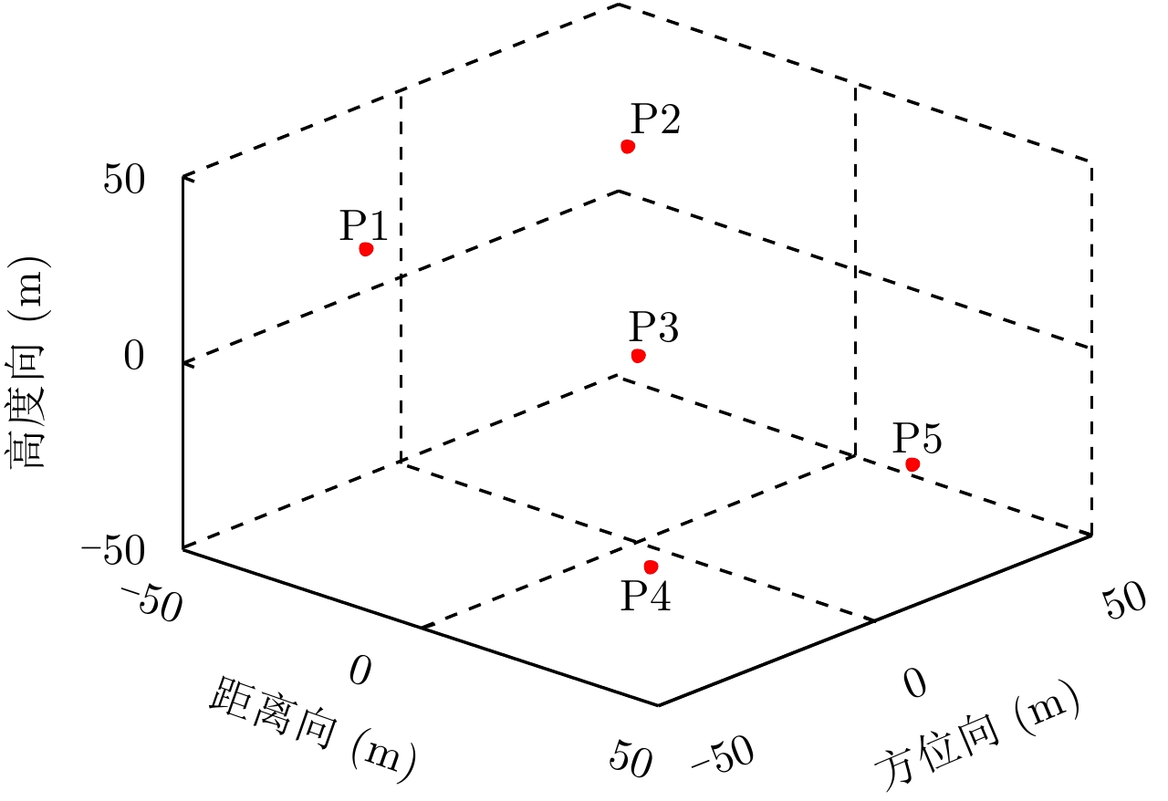
图 2 斜视多基线星载SAR 3维成像几何模型
Figure 2. 3D imaging geometry of squinted multi-baseline spaceborne SAR

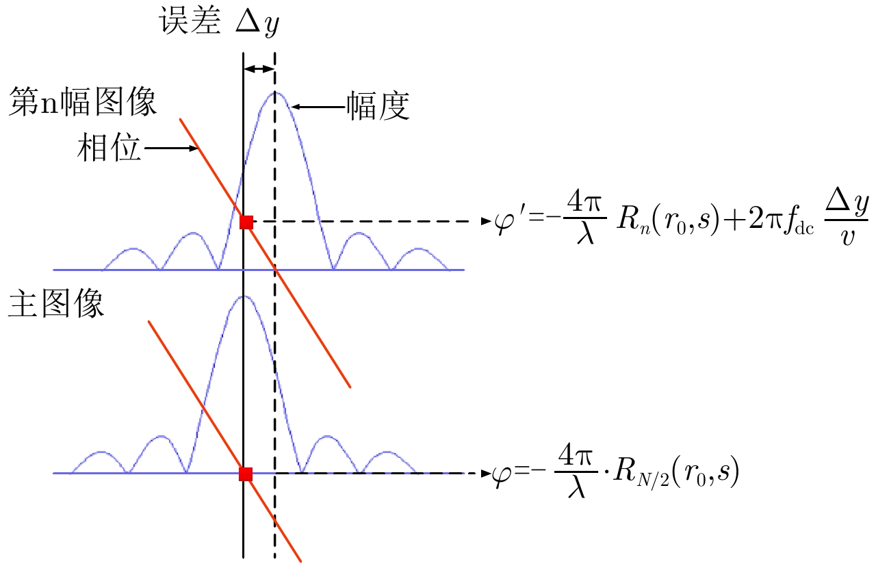
图 4 方位向配准精度随方位角的变化关系图
Figure 4. The relationship between azimuth registration accuracy and azimuth angle
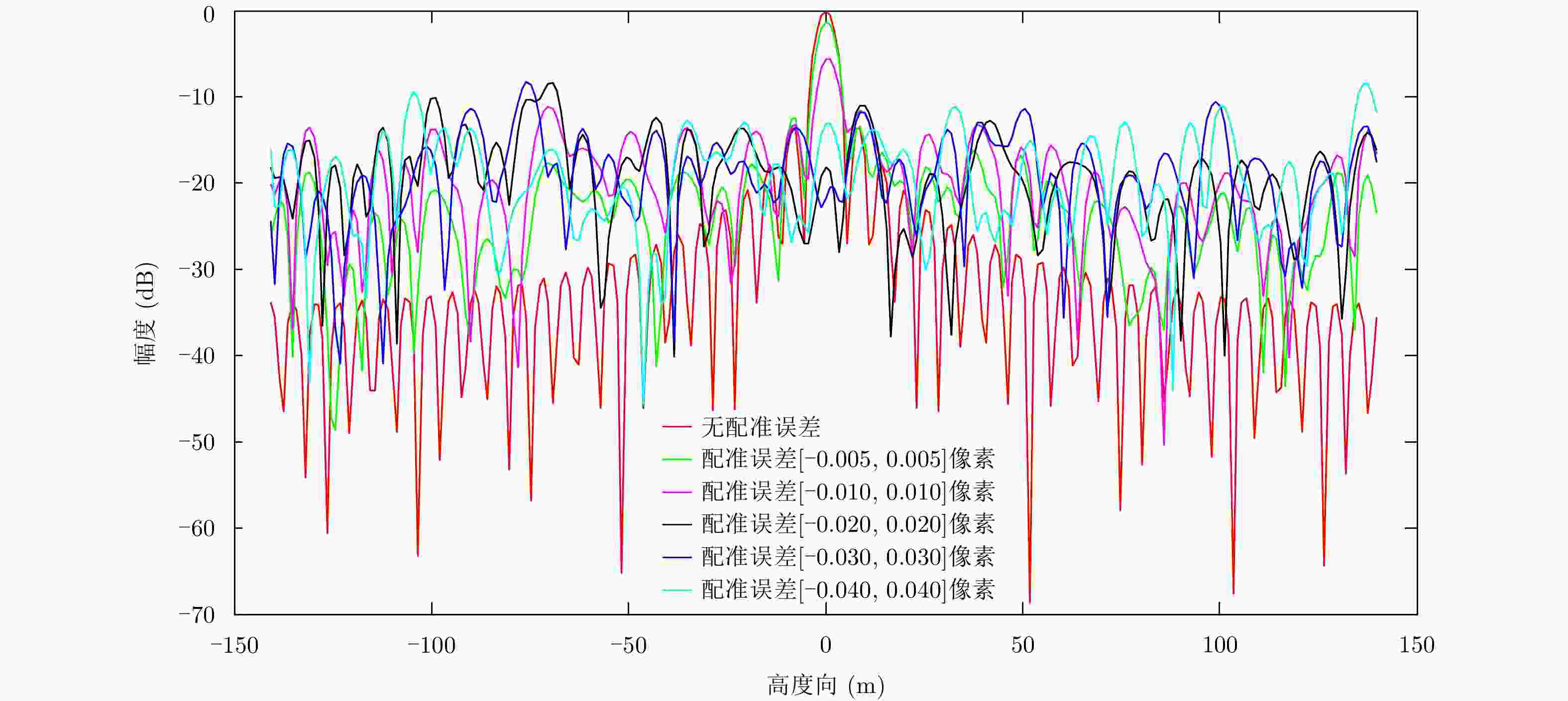
图 5 方位向配准误差对高度成像影响分析结果
Figure 5. Effect of azimuth registration error on elevation imaging
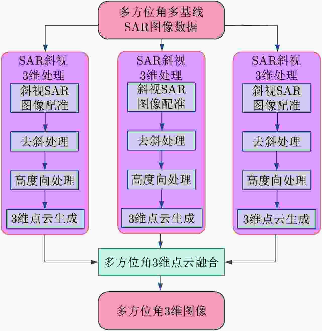
图 6 多方位角多基线星载SAR 3维成像处理流程
Figure 6. 3D imaging flowchar of multi-azimuth-angle multi-baseline spaceborne SAR
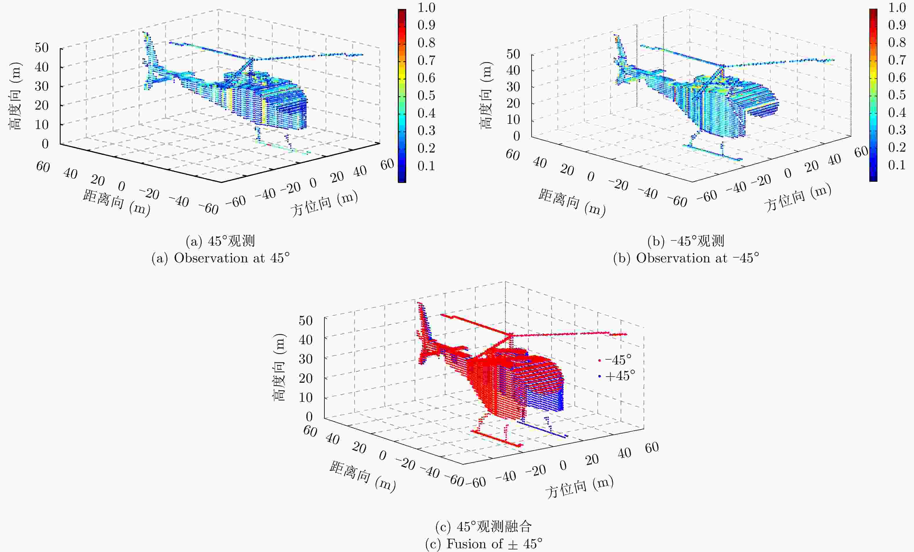
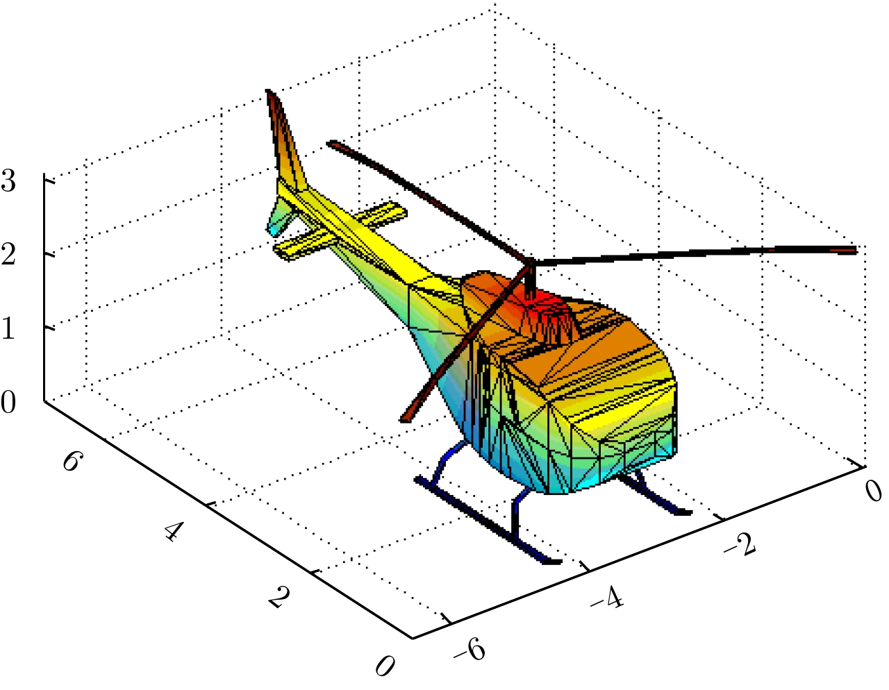
图 11 直升机模型电磁散射仿真结果
Figure 11. Simulation results of electromagnetic scattering from helicopter model
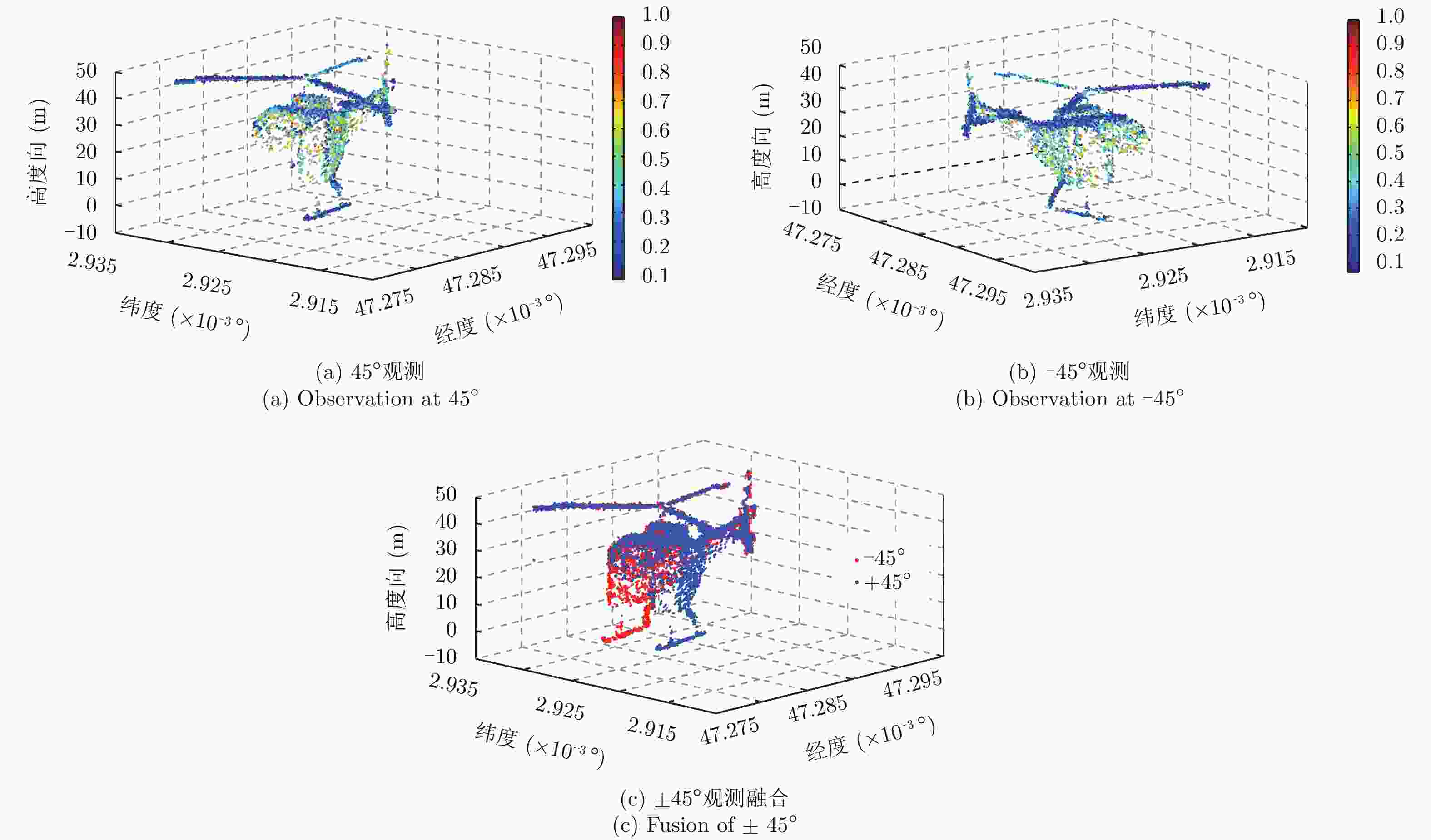
图 12 直升机目标45°和–45° 3维成像结果
Figure 12. 3D imaging result of the helicopter target at ±45°
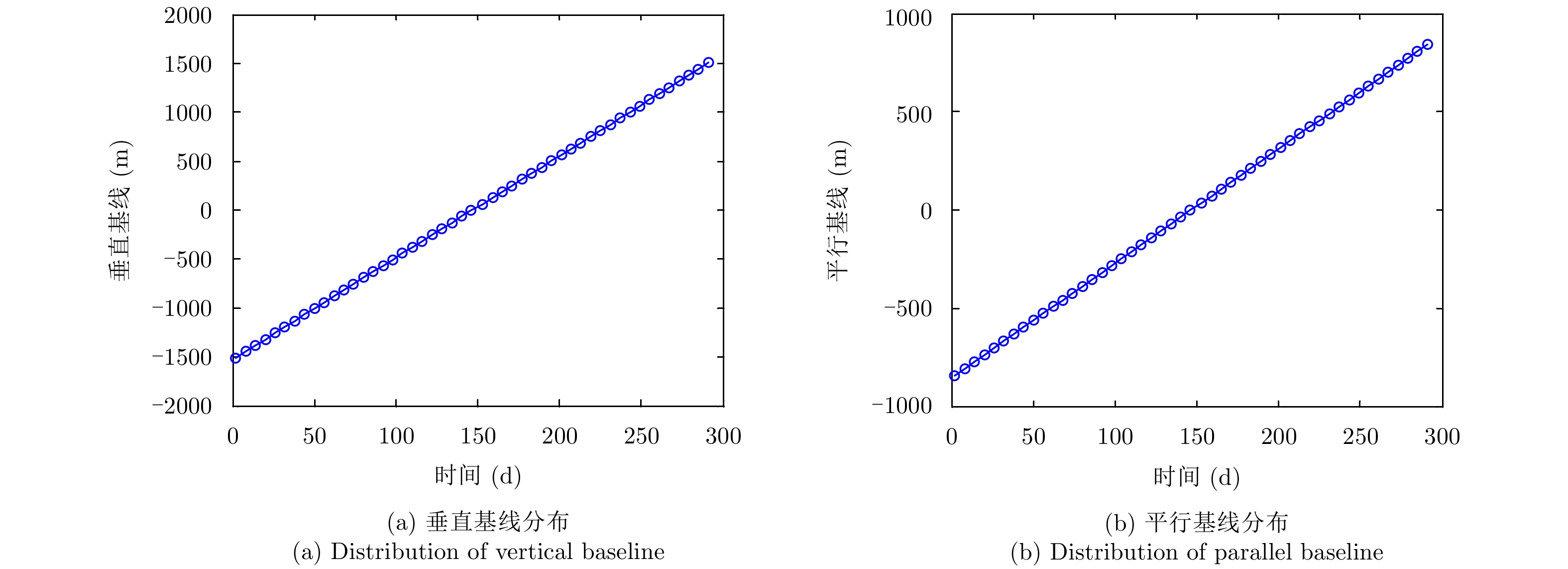
表 1 仿真参数
Table 1. Simulation parameters
参数 参数值 中心视角(°) 30 波长(m) 0.03 带宽(MHz) 300 采样率(MHz) 360 天线长度(m) 6 脉冲重复频率(Hz) 3000 轨道高度(km) 520 偏心率 0.0011 升交点赤径(°) 0 轨道倾角(°) 97.44 近地点幅角(°) 90 方位角(°) –45~45  下载: 导出CSV
-
[1] 李春升, 王伟杰, 王鹏波, 等. 星载SAR技术的现状与发展趋势[J]. 电子与信息学报, 2016, 38(1): 229–240. DOI: 10.11999/JEIT151116Li Chun-sheng, Wang Wei-jie, Wang Peng-bo, et al. Current situation and development trends of spaceborne SAR technology[J]. Journal of Electronics&Information Technology, 2016, 38(1): 229–240. DOI: 10.11999/JEIT151116 [2] Jung H S, Lu Z, Shepherd A, et al. Simulation of the SuperSAR multi-azimuth synthetic aperture radar imaging system for precise measurement of three-dimensional earth surface displacement[J]. IEEE Transactions on Geoscience and Remote Sensing, 2015, 53(11): 6196–6206. DOI: 10.1109/TGRS.2015.2435776 [3] Zhu X X and Bamler R. Very high resolution spaceborne SAR tomography in urban environment[J]. IEEE Transactions on Geoscience and Remote Sensing, 2010, 48(12): 4296–4308. DOI: 10.1109/TGRS.2010.2050487 [4] Zhu X X, Shahzad M, and Bamler R. From TomoSAR point clouds to objects: Façade reconstruction[C]. Proceedings of 2012 Tyrrhenian Workshop on Advances in Radar and Remote Sensing, Naples, Italy, 2012: 106–113. [5] Shahzad M, Zhu X X, and Bamler R. Façade structure reconstruction using spaceborne TomoSAR point clouds[C]. Proceedings of 2012 IEEE International Geoscience and Remote Sensing Symposium, Munich, Germany, 2012: 467–470. DOI: 10.1109/IGARRSS.2012.6351385. [6] Wang Y Y and Zhu X X. Feature-based fusion of tomosar point clouds from multiview TerraSAR-X data stacks[C]. Proceedings of 2013 IEEE International Geoscience and Remote Sensing Symposium, Melbourne, Australia, 2013: 85–88. DOI: 10.1109/IGARSS.2013.6721098. [7] Zhu X X and Shahzad M. Facade reconstruction using multiview spaceborne TomoSAR point clouds[J]. IEEE Transactions on Geoscience and Remote Sensing, 2014, 52(6): 3541–3552. DOI: 10.1109/TGRS.2013.2273619 [8] Fornaro G, Serafino F, and Soldovieri F. Three-dimensional focusing with multipass SAR data[J]. IEEE Transactions on Geoscience and Remote Sensing, 2003, 41(3): 507–517. DOI: 10.1109/TGRS.2003.809934 [9] 孙希龙. SAR层析与差分层析成像技术研究[D]. [博士论文], 国防科学技术大学, 2012.Sun Xi-long. Research on SAR tomography and differential SAR tomography imaging technology[D]. [Ph.D. dissertation], National University of Defense Technology, 2012. [10] Curlander J C and McDonough R N. Synthetic Aperture Radar: Systems and Signal Processing[M]. New York: John Wiley & Sons, 1991. [11] Bara M, Scheiber R, Broquetas A, et al. Interferometric SAR signal analysis in the presence of squint[J]. IEEE Transactions on Geoscience and Remote Sensing, 2000, 38(5): 2164–2178. DOI: 10.1109/36.868875 [12] Schmitt M. Reconstruction of urban surface models from multi-aspect and multi-baseline interferometric SAR[D]. [Ph.D. dissertation], Technische Universität München, 2014. [13] 周月琴, 郑肇葆, 李德仁, 等. SAR图像立体定位原理与精度分析[J]. 遥感学报, 1998, 2(4): 245–250. DOI: 10.11834/jrs.19980402Zhou Yue-qin, Zheng Zhao-bao, Li De-ren, et al. Stereopair positioning algorithm for SAR images and its accuracy analysis model[J]. Journal of Remote Sensing, 1998, 2(4): 245–250. DOI: 10.11834/jrs.19980402 [14] 王青松, 黄海风, 董臻. 星载干涉合成孔径雷达[M]. 北京: 科学出版社, 2012.Wang Qing-song, Huang Hai-feng, and Dong Zhen. Spaceborne Interferometric SAR[M]. Beijing: Science Press, 2012. [15] 王金峰. SAR层析三维成像技术研究[D]. [博士论文], 电子科技大学, 2010.Wang Jin-feng. Study of three-dimentional synthetic aperture radar tomography imaging technology[D]. [Ph.D. dissertation], University of Electronic Science and Technology of China, 2010. [16] Moreira A and Scheiber R. A new method for accurate co-registration of interferometric SAR images[C]. 1998 IEEE International Geoscience and Remote Sensing. Symposium Proceedings, Seattle, USA, 1998, 2: 1091–1093. DOI: 10.1109/IGARSS.1998.699682. [17] Yee K. Numerical solution of initial boundary value problems involving maxwell’s equations in isotropic media[J]. IEEE Transactions on Antennas and Propagation, 1966, 14(3): 302–307. DOI: 10.1109/TAP.1966.1138693 -


计量
- 文章访问数:
- HTML全文浏览量:
- PDF下载量:
- 被引次数: 0

