
 Submit Manuscript
 Peer Review
 Editor Work
2017 Vol. 6, No. 6
 Previous Issue
 Abstract
 2316KB
Used to suppress strong clutter and jamming in airborne radar data, Space Time Adaptive Processing (STAP) is a multidimensional adaptive filtering technique that simultaneously combines signals from elements of an antenna array and multiple pulses of coherent radar waveforms. As a key technology for improving the performance of airborne radar, it has attracted much attention in the field of radar research and from powerful military nations in recent years. In this paper, the research and development status of STAP technology is reviewed including methodologies, experimental systems, and applications and we focus on the key technical problems encountered during its development. Then, the application of STAP technology in equipment is introduced. Finally, the next development trends, future directions, and areas worthy of further research are presented.
Used to suppress strong clutter and jamming in airborne radar data, Space Time Adaptive Processing (STAP) is a multidimensional adaptive filtering technique that simultaneously combines signals from elements of an antenna array and multiple pulses of coherent radar waveforms. As a key technology for improving the performance of airborne radar, it has attracted much attention in the field of radar research and from powerful military nations in recent years. In this paper, the research and development status of STAP technology is reviewed including methodologies, experimental systems, and applications and we focus on the key technical problems encountered during its development. Then, the application of STAP technology in equipment is introduced. Finally, the next development trends, future directions, and areas worthy of further research are presented.
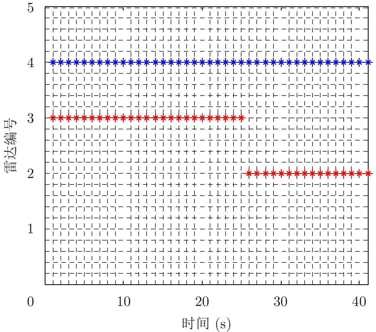
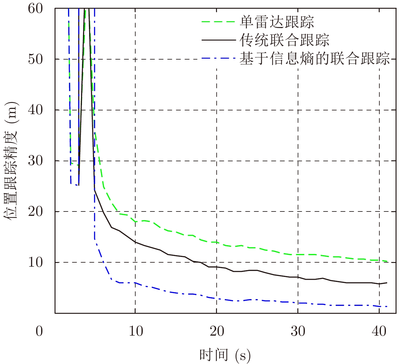
Nowadays, the battlefield environment has become much more complex and variable. This paper presents a quantitative method and lower bound for the amount of target information acquired from multiple radar observations to adaptively and dynamically organize the detection of battlefield resources based on the principle of information entropy. Furthermore, for minimizing the given information entropy’s lower bound for target measurement at every moment, a method to dynamically and adaptively select radars with a high amount of information for target tracking is proposed. The simulation results indicate that the proposed method has higher tracking accuracy than that of tracking without adaptive radar selection based on entropy.
Nowadays, the battlefield environment has become much more complex and variable. This paper presents a quantitative method and lower bound for the amount of target information acquired from multiple radar observations to adaptively and dynamically organize the detection of battlefield resources based on the principle of information entropy. Furthermore, for minimizing the given information entropy’s lower bound for target measurement at every moment, a method to dynamically and adaptively select radars with a high amount of information for target tracking is proposed. The simulation results indicate that the proposed method has higher tracking accuracy than that of tracking without adaptive radar selection based on entropy.


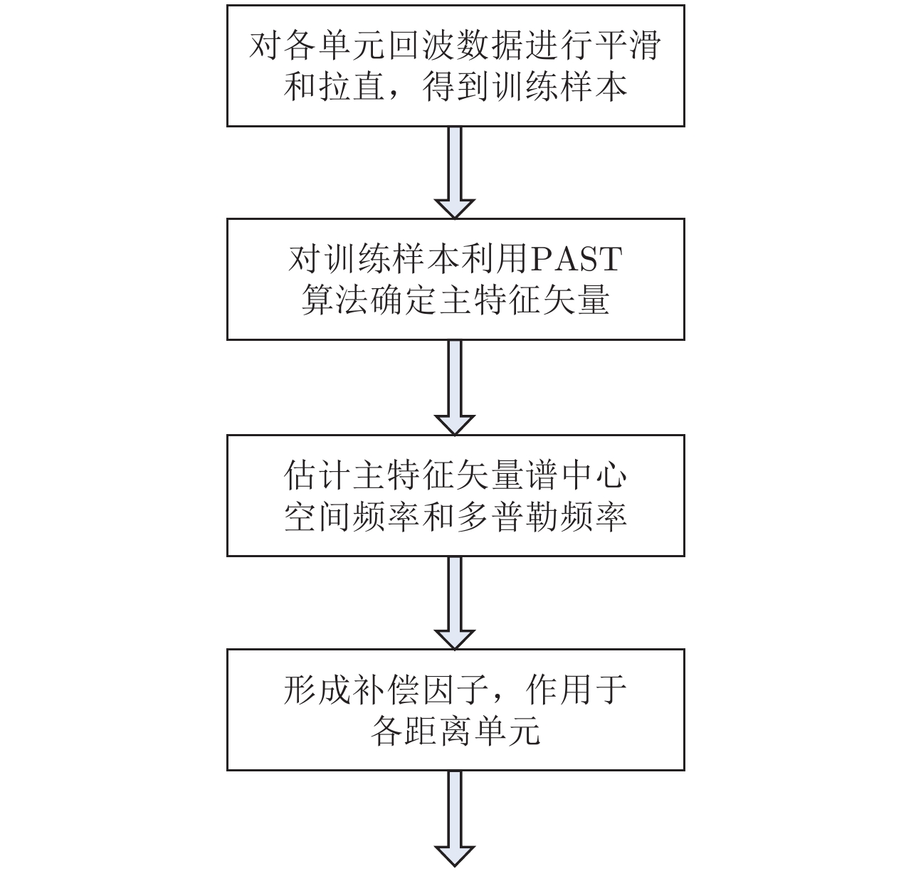
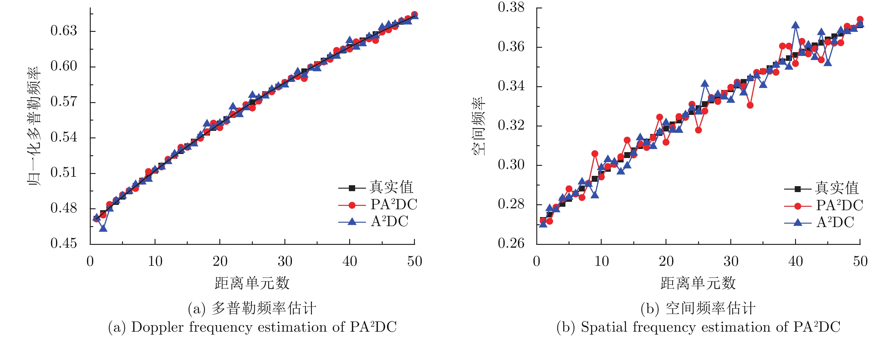
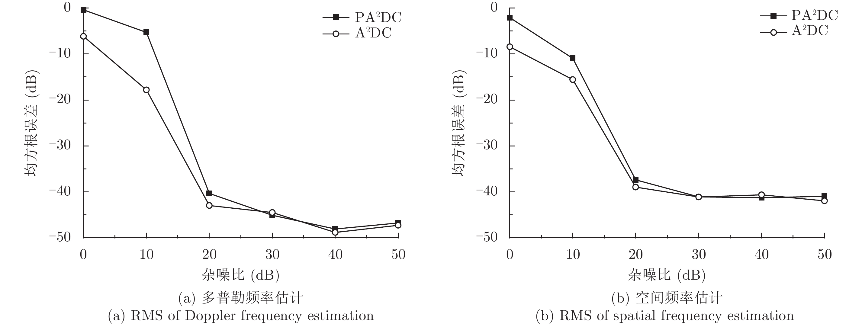
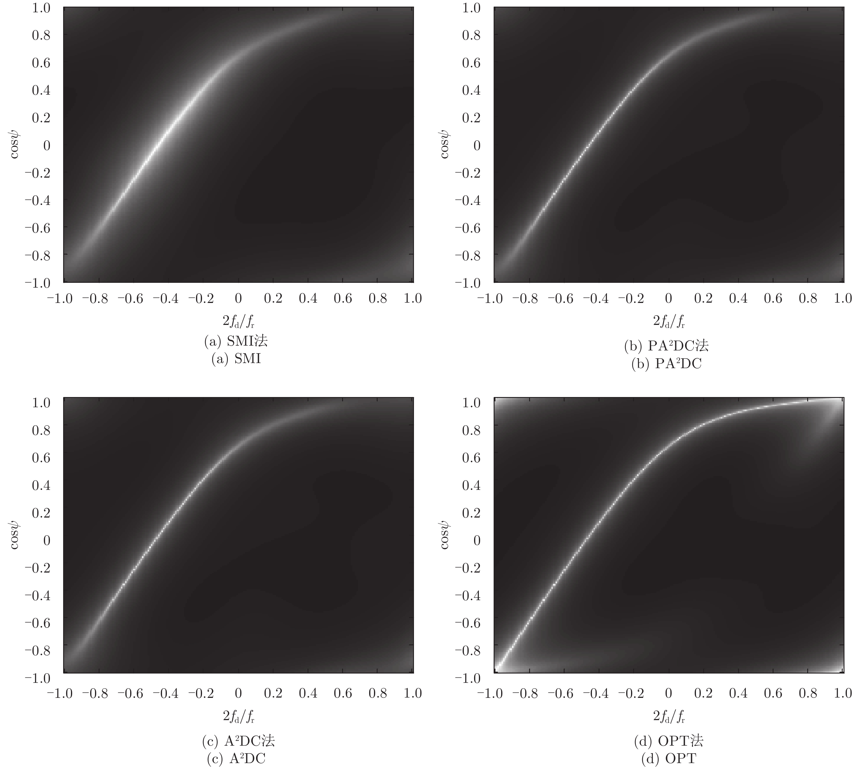
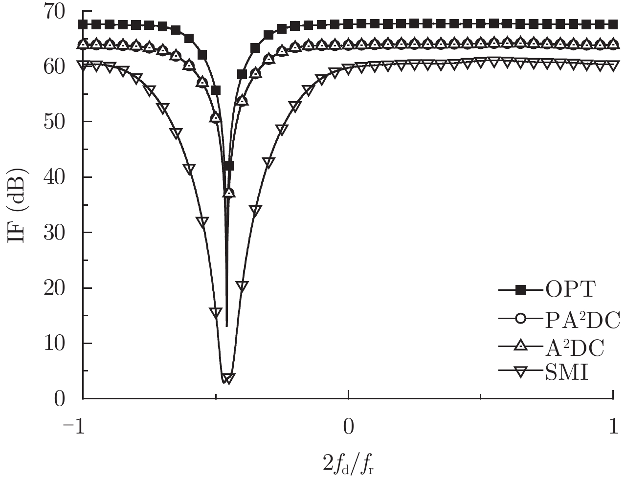
The adaptive angle-Doppler compensation method adaptively extracts requisite information based on the data itself, thereby avoiding the problem of performance degradation due to inertial system error. However, this method requires the estimation and eigen decomposition of a sample covariance matrix, which has high computational complexity and limits its real-time application. In this paper, we investigate an adaptive angle-Doppler compensation method based on Projection Approximation Subspace Tracking (PAST). This method uses cyclic iterative processing to quickly estimate the positions of the spectral center of the maximum eigenvector in each range cell, thereby avoiding the computational burden of matrix estimation and eigen decompositon. Then, the spectral centers of all range cells are overlapped by two-dimensional compensation. Our simulation results demonstrate that the proposed method can effectively reduce the nonhomogeneity of airborne bistatic radar, with a performance is similar to that of eigen-decomposition algorithms, but with a reduced computational load and easy implementation.
The adaptive angle-Doppler compensation method adaptively extracts requisite information based on the data itself, thereby avoiding the problem of performance degradation due to inertial system error. However, this method requires the estimation and eigen decomposition of a sample covariance matrix, which has high computational complexity and limits its real-time application. In this paper, we investigate an adaptive angle-Doppler compensation method based on Projection Approximation Subspace Tracking (PAST). This method uses cyclic iterative processing to quickly estimate the positions of the spectral center of the maximum eigenvector in each range cell, thereby avoiding the computational burden of matrix estimation and eigen decompositon. Then, the spectral centers of all range cells are overlapped by two-dimensional compensation. Our simulation results demonstrate that the proposed method can effectively reduce the nonhomogeneity of airborne bistatic radar, with a performance is similar to that of eigen-decomposition algorithms, but with a reduced computational load and easy implementation.

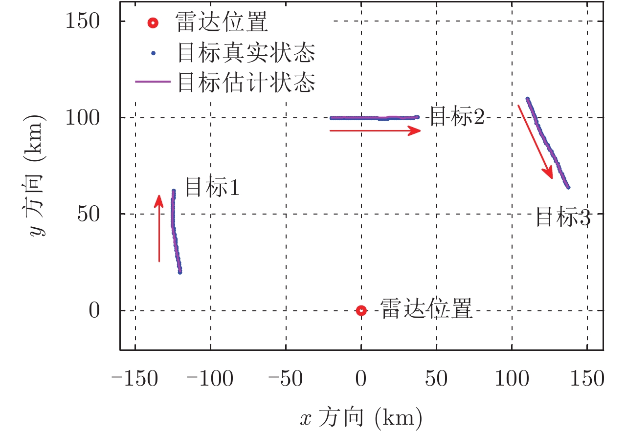
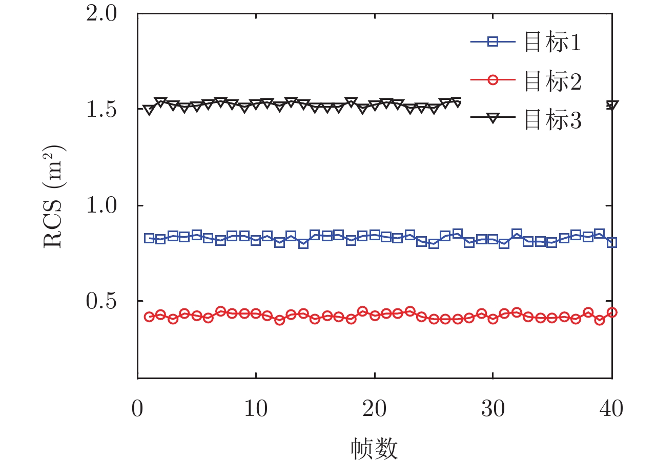
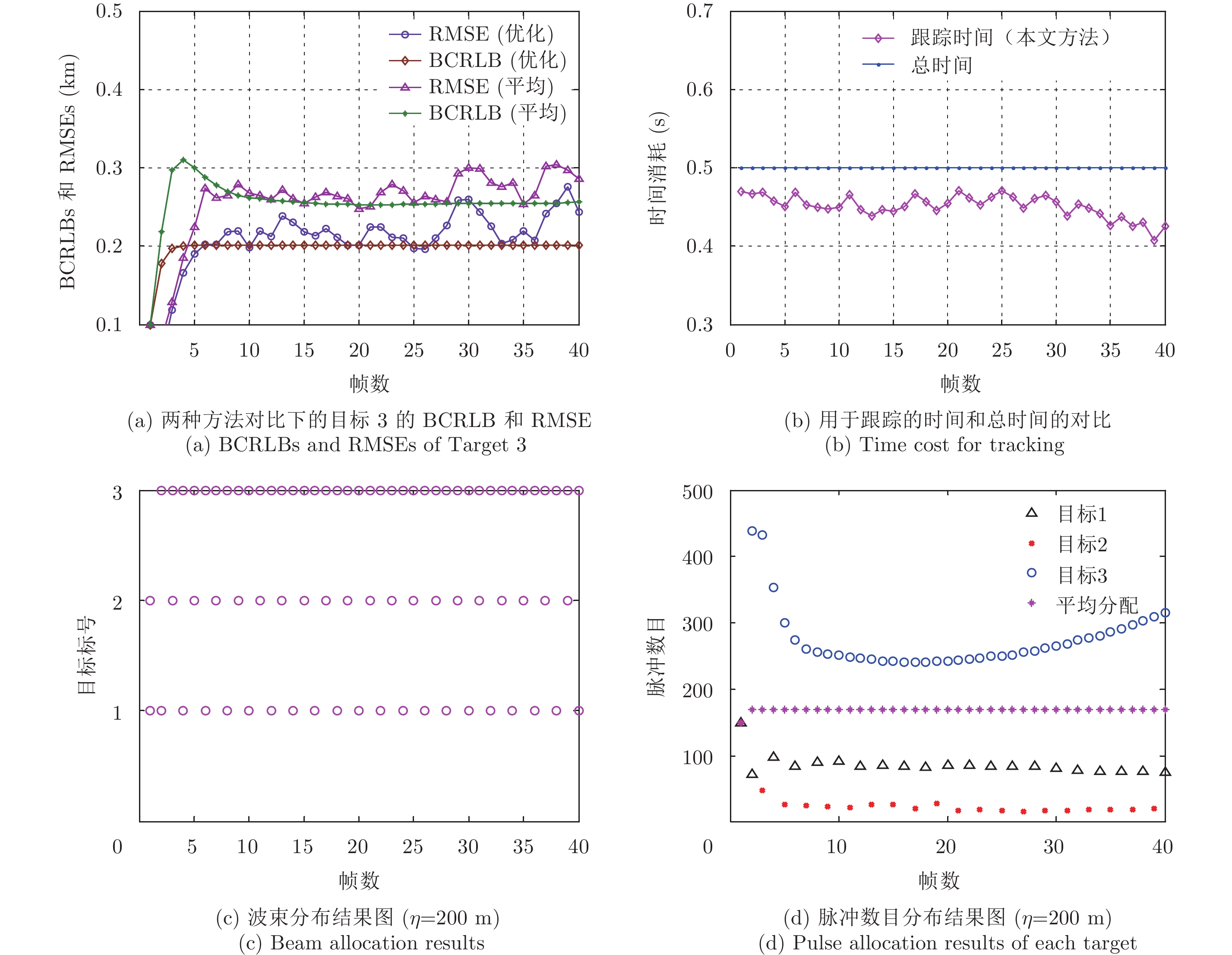
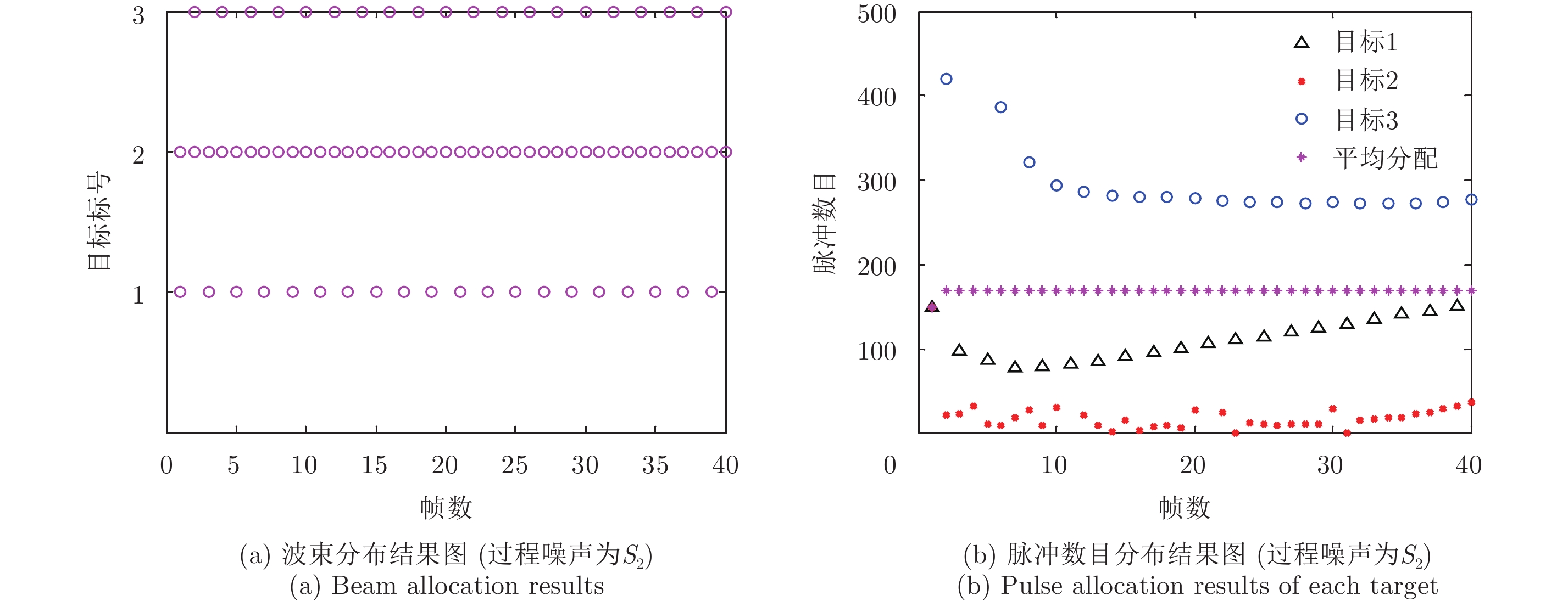
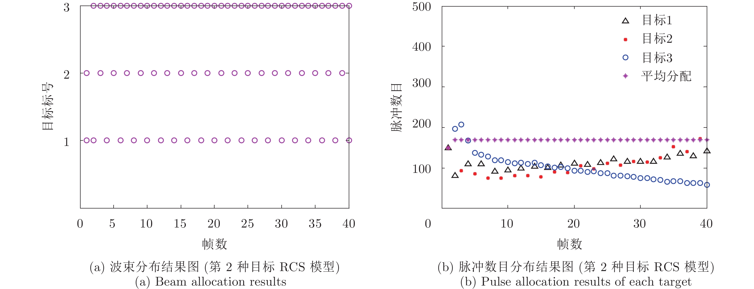
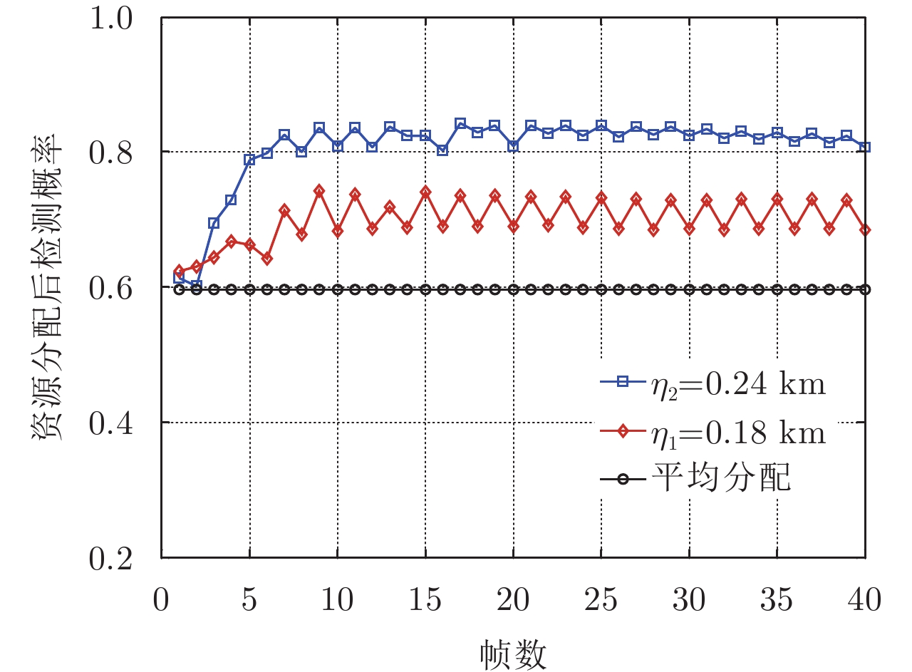
Phased array radar can simultaneously form multiple beams that can scan without inertia allowing for flexible pointing. In this paper, we propose a joint beam and dwell time allocation strategy for multi-target tracking in a phased array radar system to achieve multi-target tracking with less system resources. First, we formulate an optimization problem for minimizing the total dwell time on all targets while guaranteeing to meet a predetermined target-tracking accuracy requirement. The Bayesian Cramer-Rao Lower Bound (BCRLB) is introduced as the tracking performance metric since it provides a lower bound for the error of target state estimate. Second, after proving the optimization problem is nonconvex, we propose a two-step decomposition algorithm which is first to determine the beam pointing and then allocate the beam dwell time to solve it. Finally, we achieve multi-target tracking based on the resource allocation results. Simulation results show that our optimization strategy is effective in saving resources and is favorable for achieving a better tracking performance of worse targets as compared to an operating mode wherein uniform resource allocation occurs.
Phased array radar can simultaneously form multiple beams that can scan without inertia allowing for flexible pointing. In this paper, we propose a joint beam and dwell time allocation strategy for multi-target tracking in a phased array radar system to achieve multi-target tracking with less system resources. First, we formulate an optimization problem for minimizing the total dwell time on all targets while guaranteeing to meet a predetermined target-tracking accuracy requirement. The Bayesian Cramer-Rao Lower Bound (BCRLB) is introduced as the tracking performance metric since it provides a lower bound for the error of target state estimate. Second, after proving the optimization problem is nonconvex, we propose a two-step decomposition algorithm which is first to determine the beam pointing and then allocate the beam dwell time to solve it. Finally, we achieve multi-target tracking based on the resource allocation results. Simulation results show that our optimization strategy is effective in saving resources and is favorable for achieving a better tracking performance of worse targets as compared to an operating mode wherein uniform resource allocation occurs.

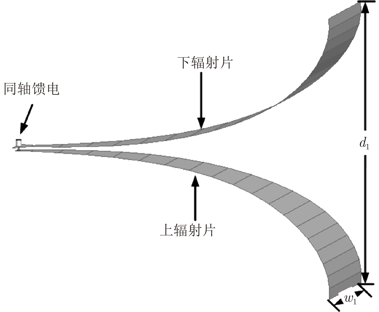
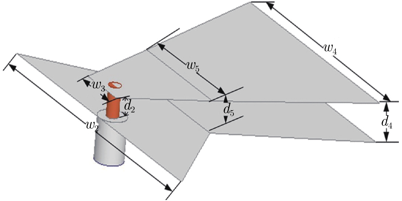
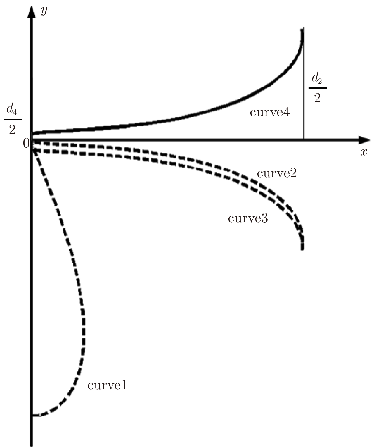
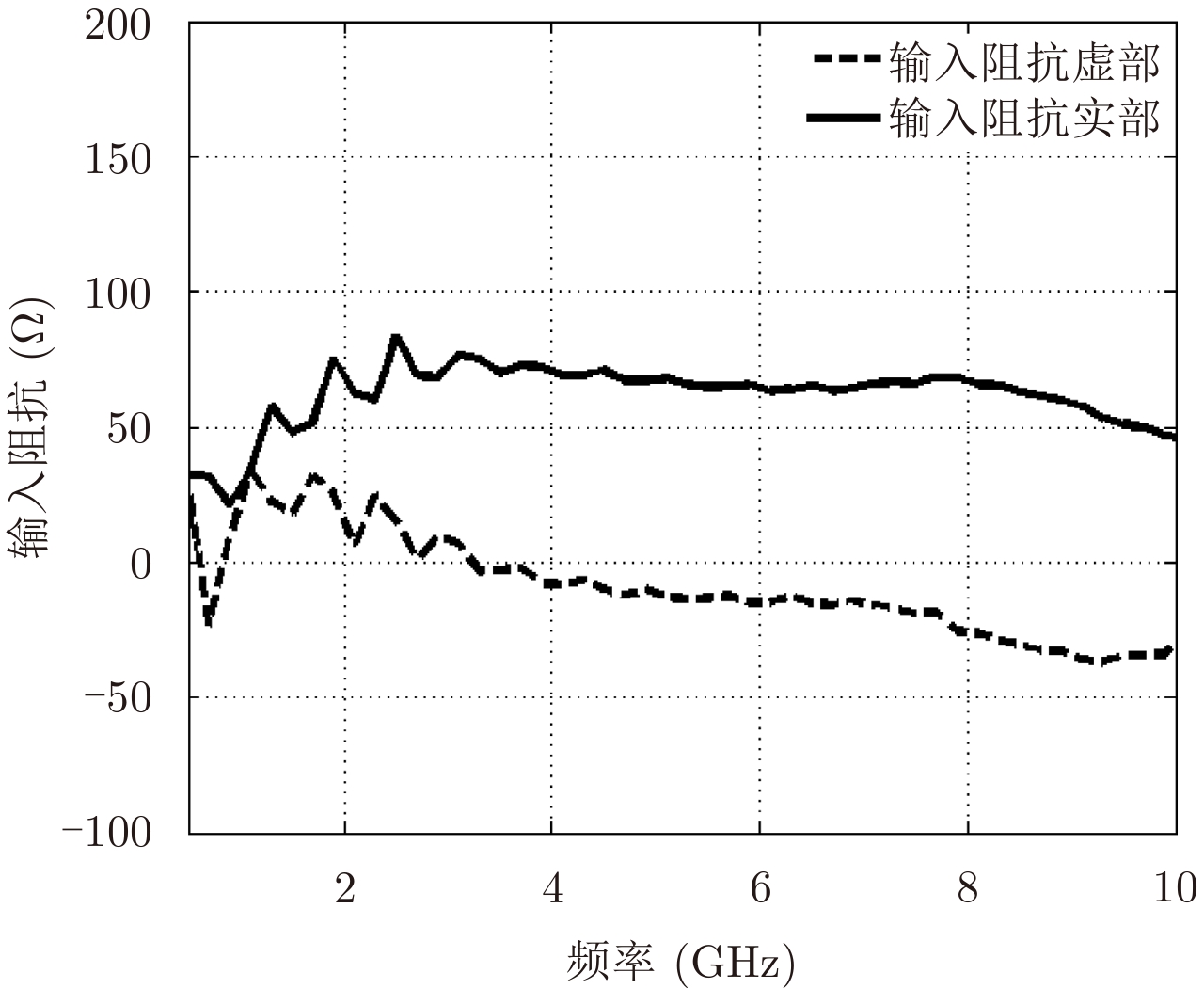
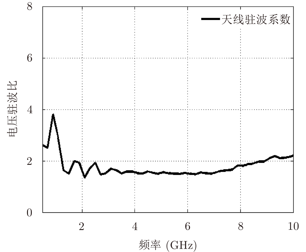
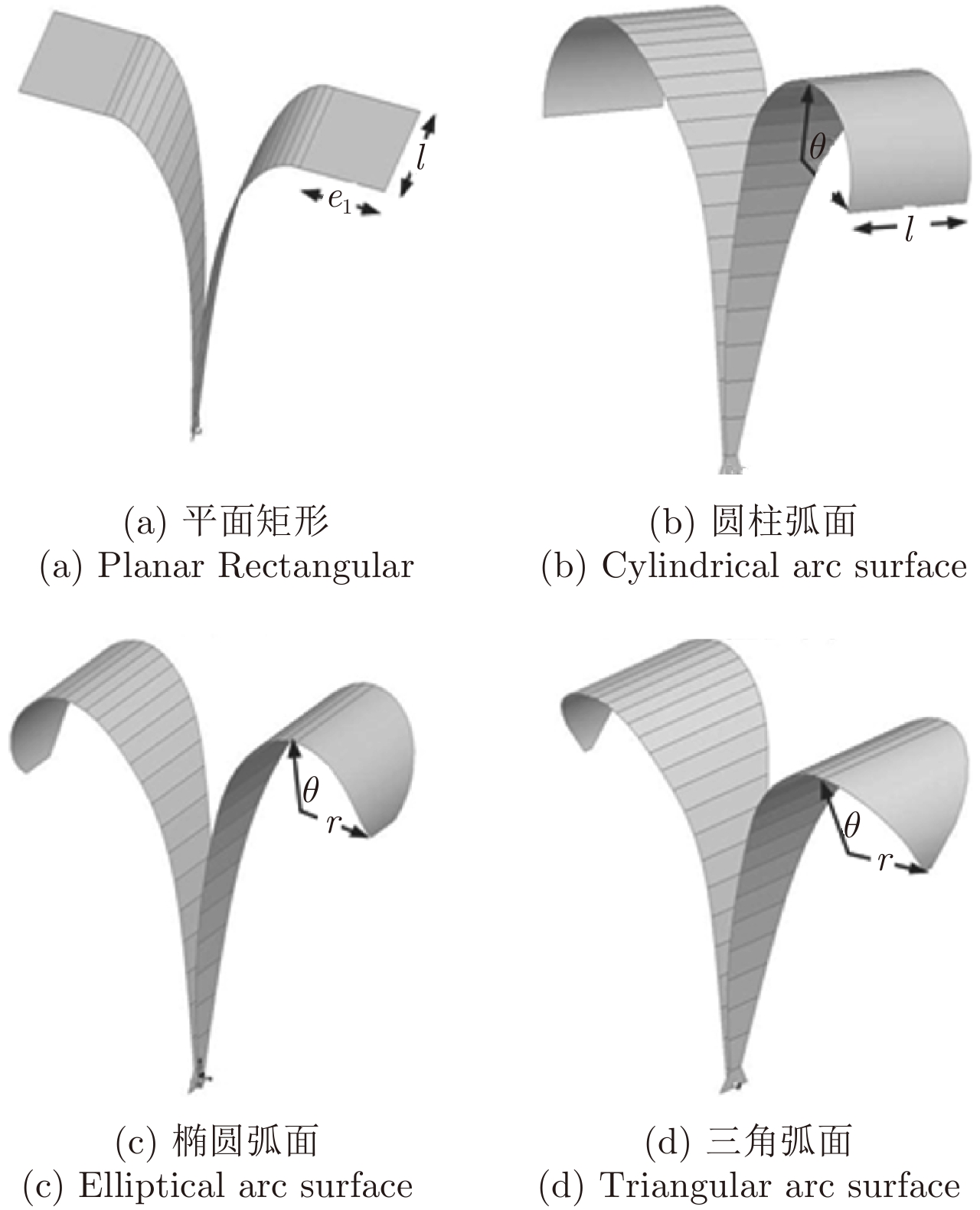
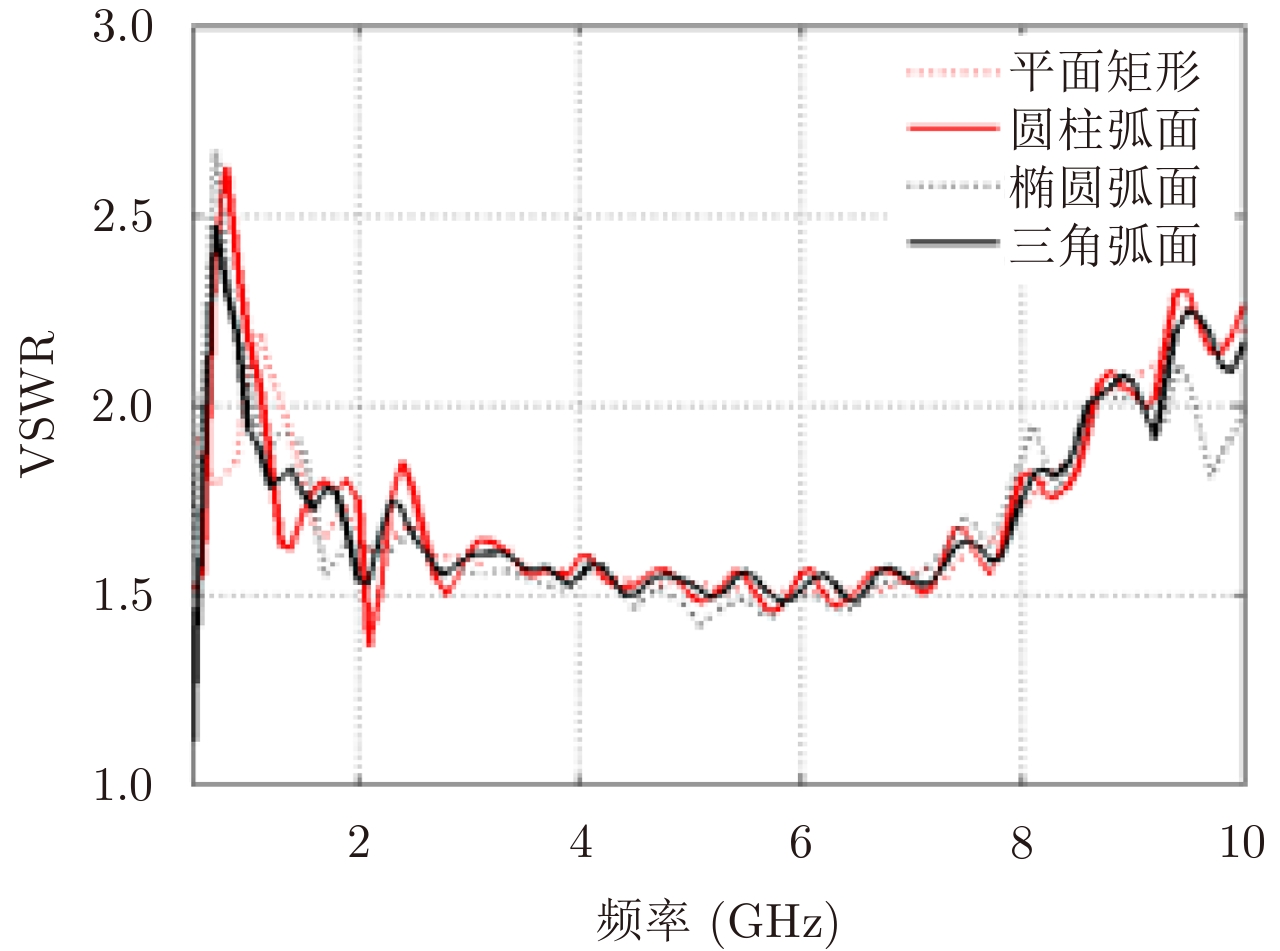
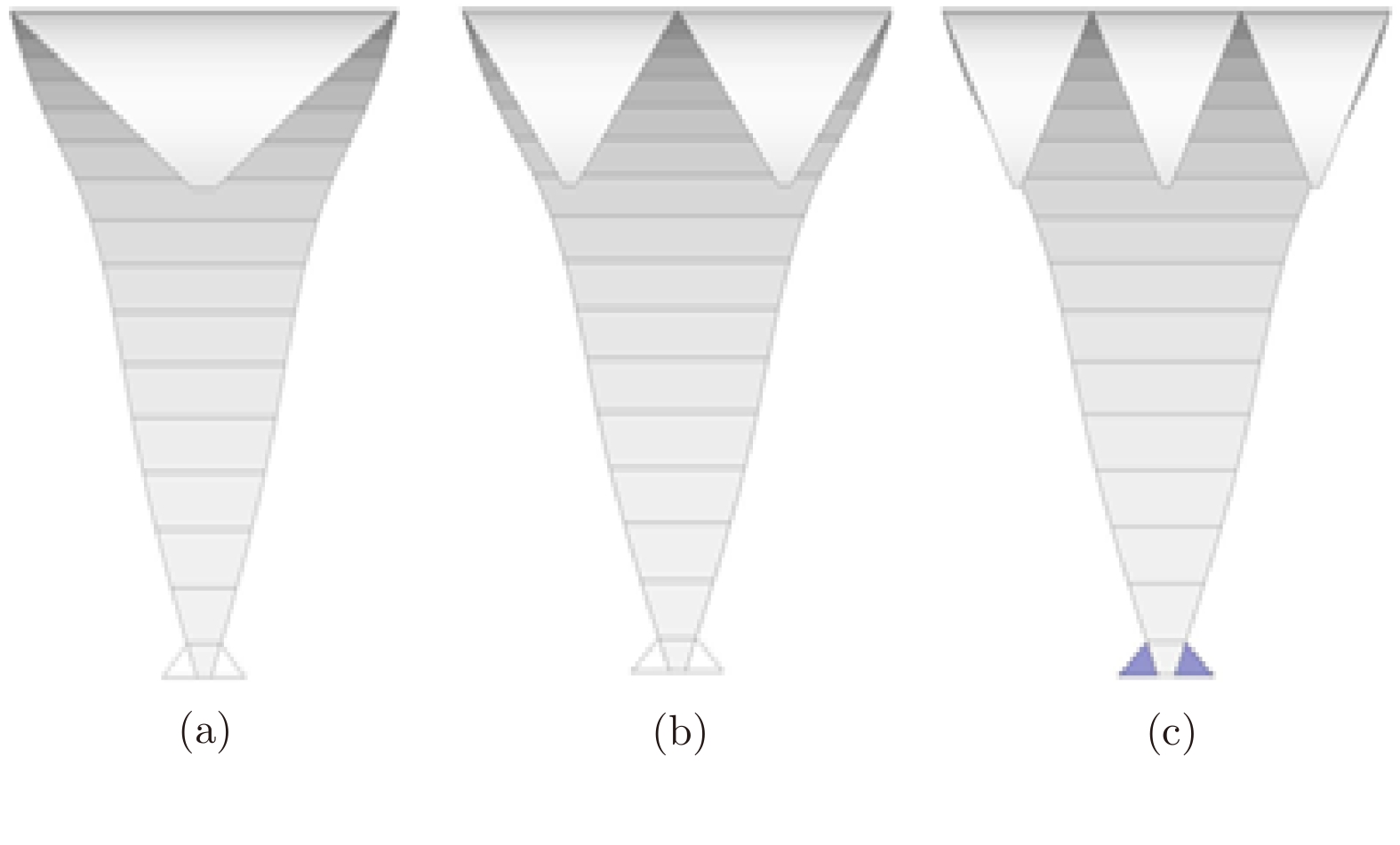
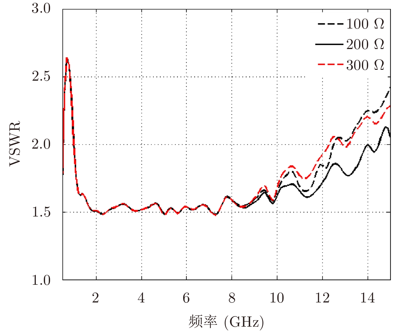
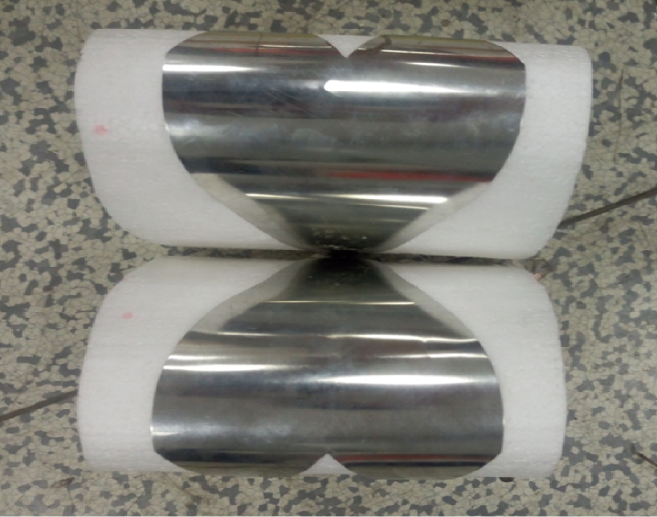
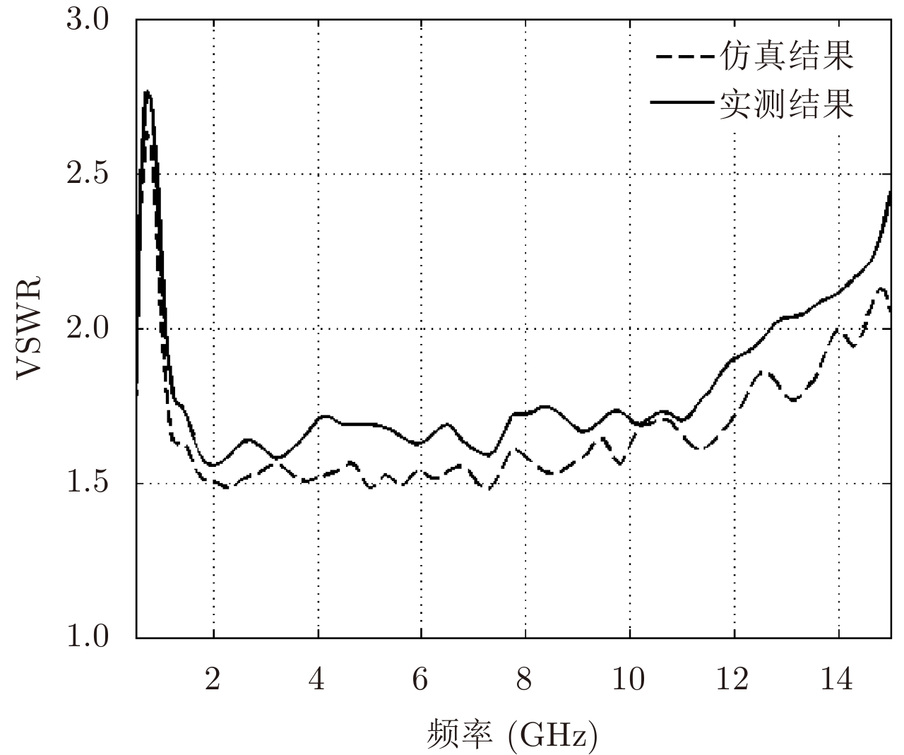
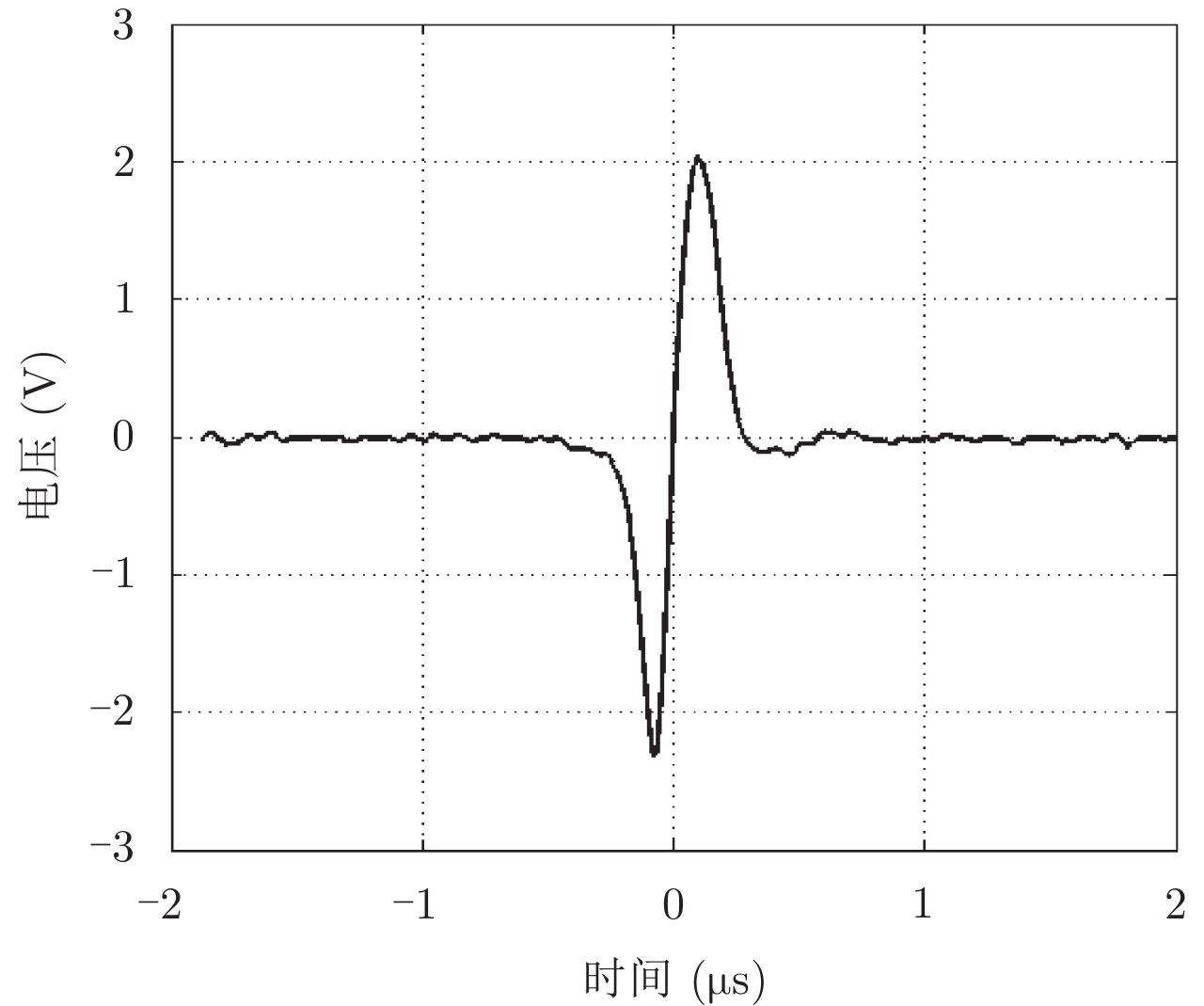
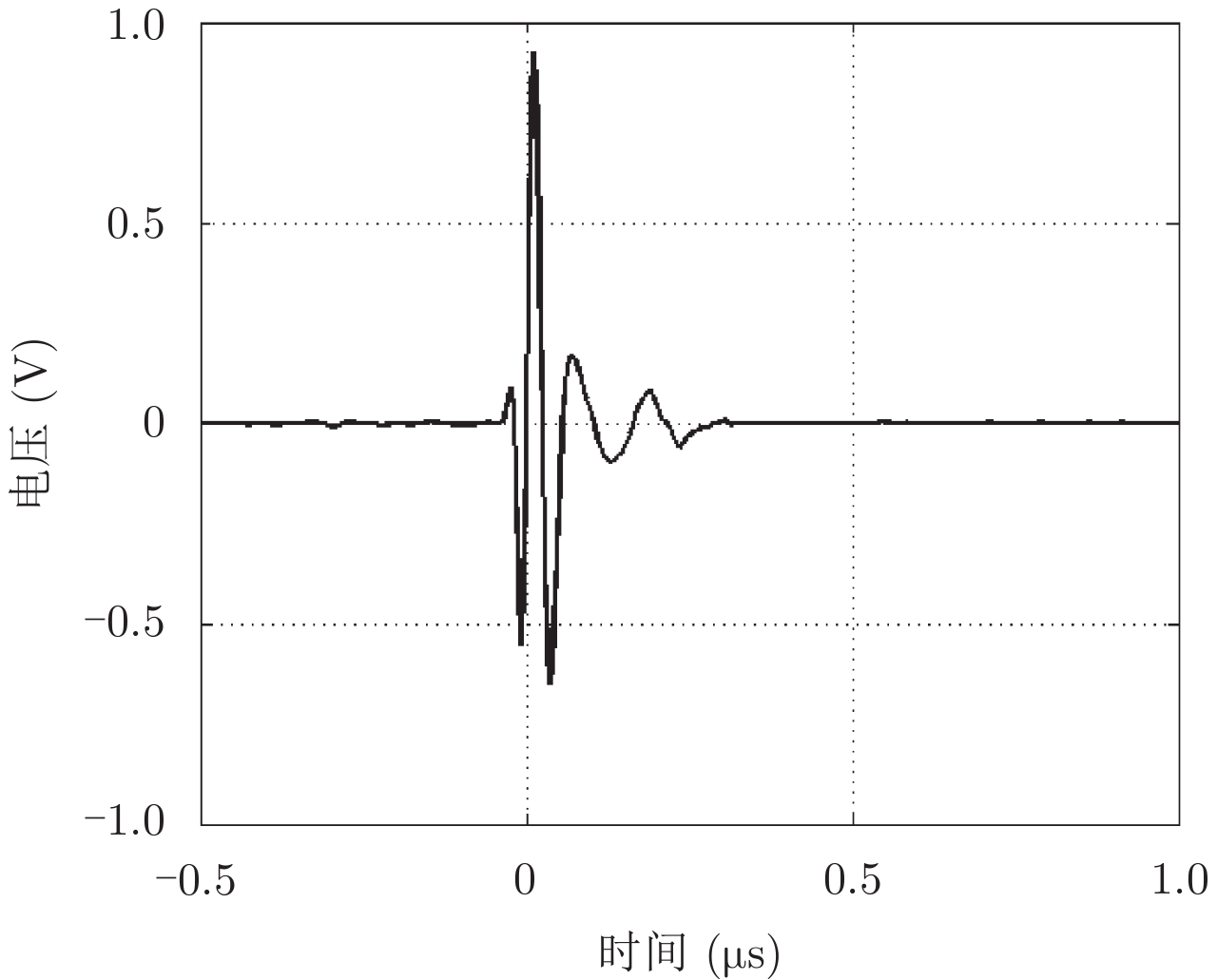
Based on transmission line theory and impedance transition, we design an ultra-wideband Transverse ElectroMagnetic (TEM) horn antenna that takes advantage of index gradient structure and loading techniques and is optimized for highway Ground Penetrating Radar (GPR) applications. We use numerical simulation to analyze the effects of different curved surfaces as an extension of the antenna and further improve the antenna performance by the use of a metallic reflective cavity and distributed resistor loading. We then fabricated an antenna based on the optimization results and determined the Voltage Standing Wave Ratio (VSWR) of the antenna to be less than 2 for bandwidths ranging from 0.9–12.6 GHz. The waveform fidelity of the antenna is also good and when we applied this antenna to highway scenarios, it achieved good results.
Based on transmission line theory and impedance transition, we design an ultra-wideband Transverse ElectroMagnetic (TEM) horn antenna that takes advantage of index gradient structure and loading techniques and is optimized for highway Ground Penetrating Radar (GPR) applications. We use numerical simulation to analyze the effects of different curved surfaces as an extension of the antenna and further improve the antenna performance by the use of a metallic reflective cavity and distributed resistor loading. We then fabricated an antenna based on the optimization results and determined the Voltage Standing Wave Ratio (VSWR) of the antenna to be less than 2 for bandwidths ranging from 0.9–12.6 GHz. The waveform fidelity of the antenna is also good and when we applied this antenna to highway scenarios, it achieved good results.


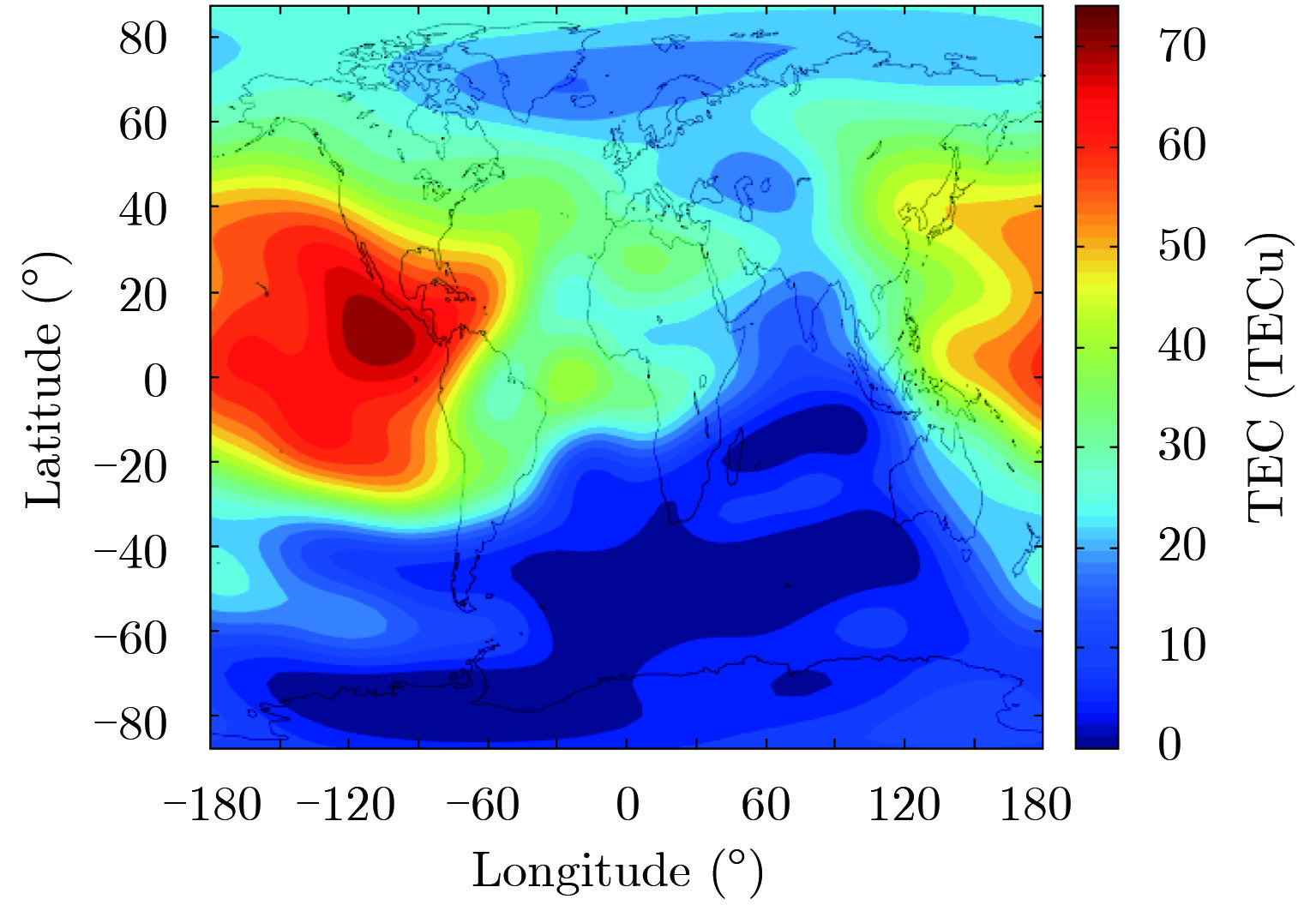
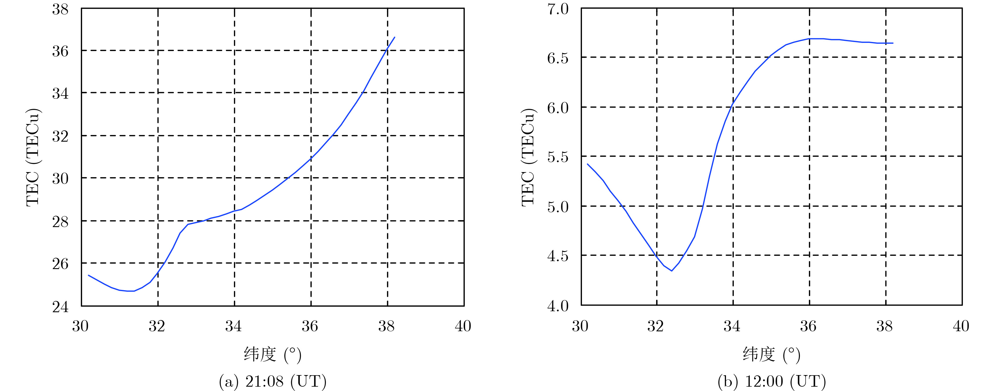
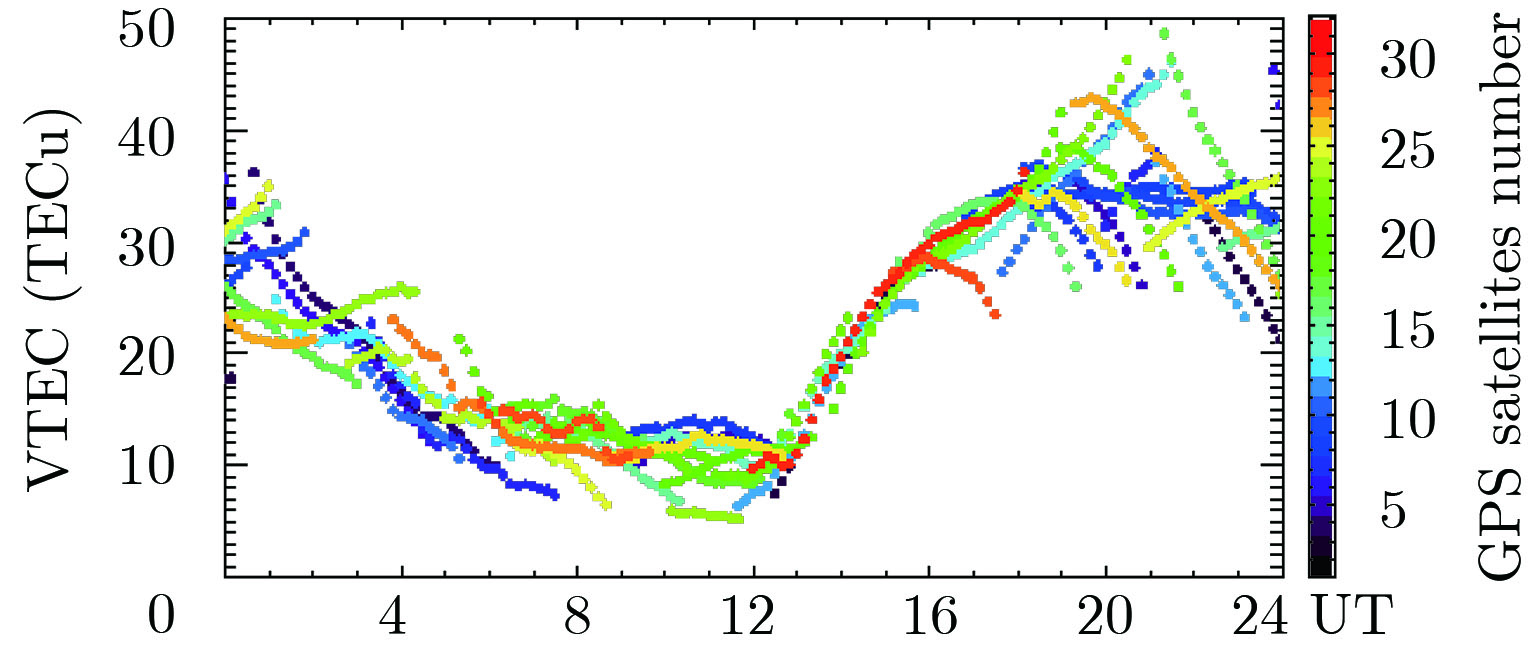
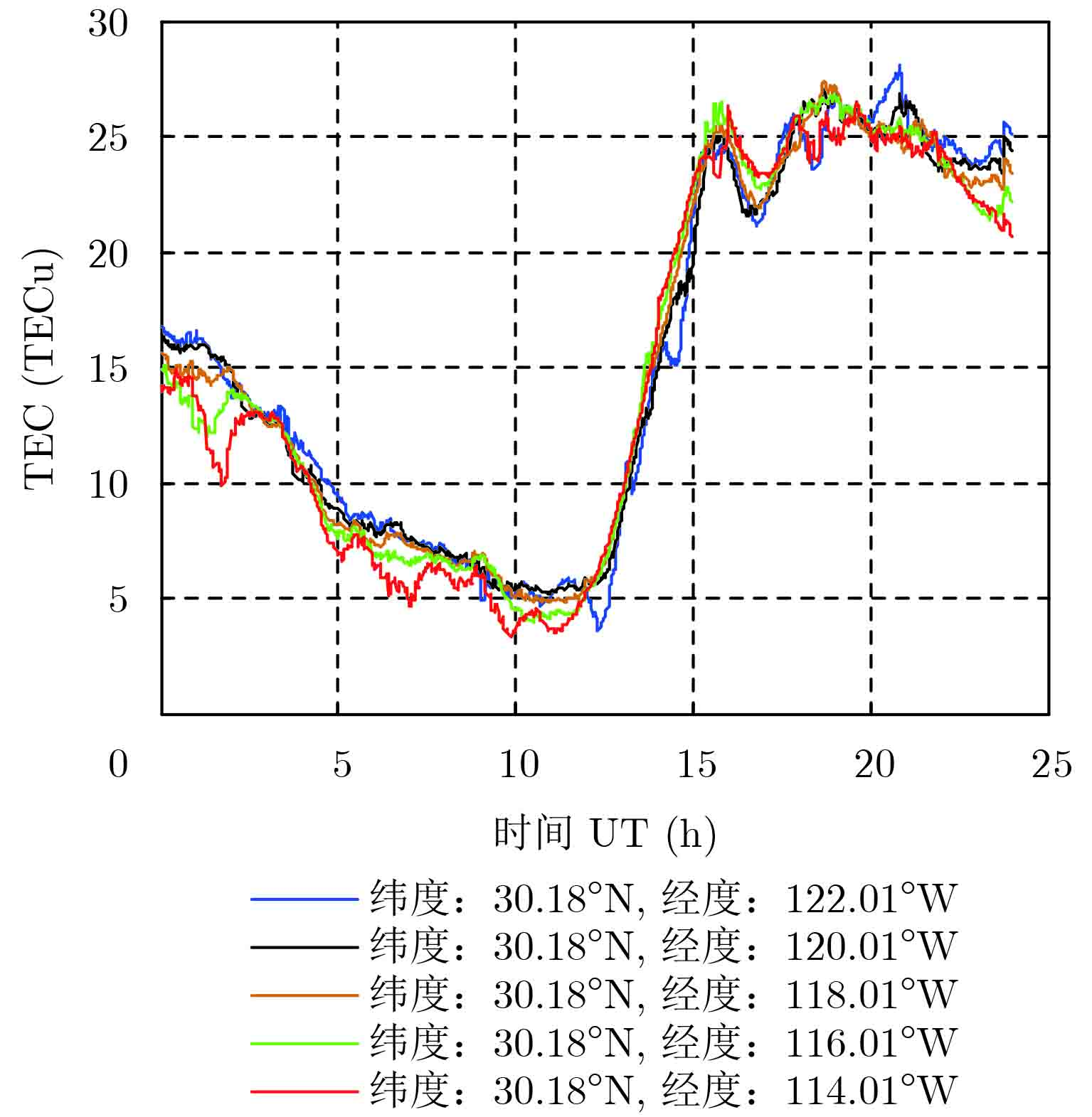
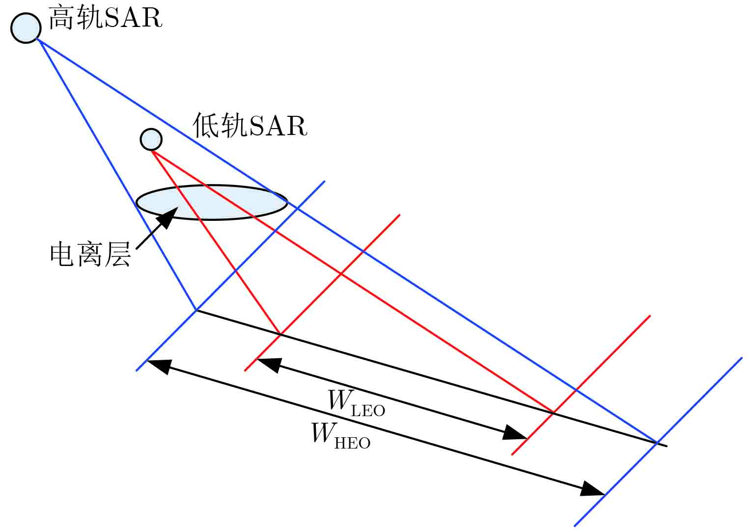
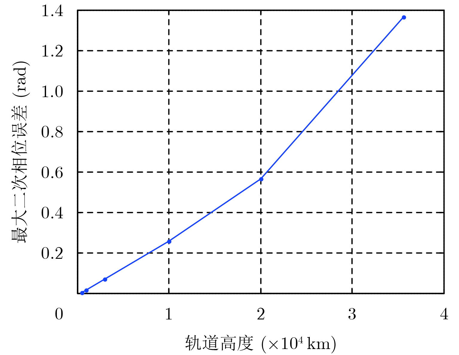
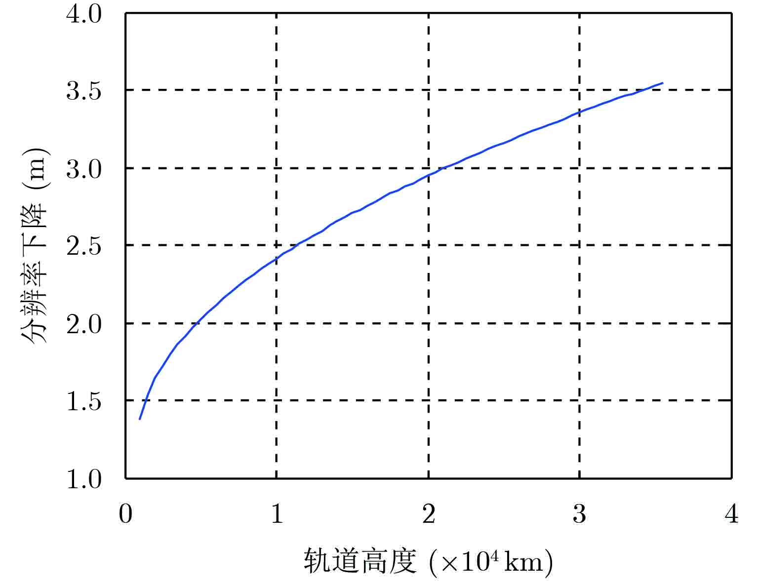
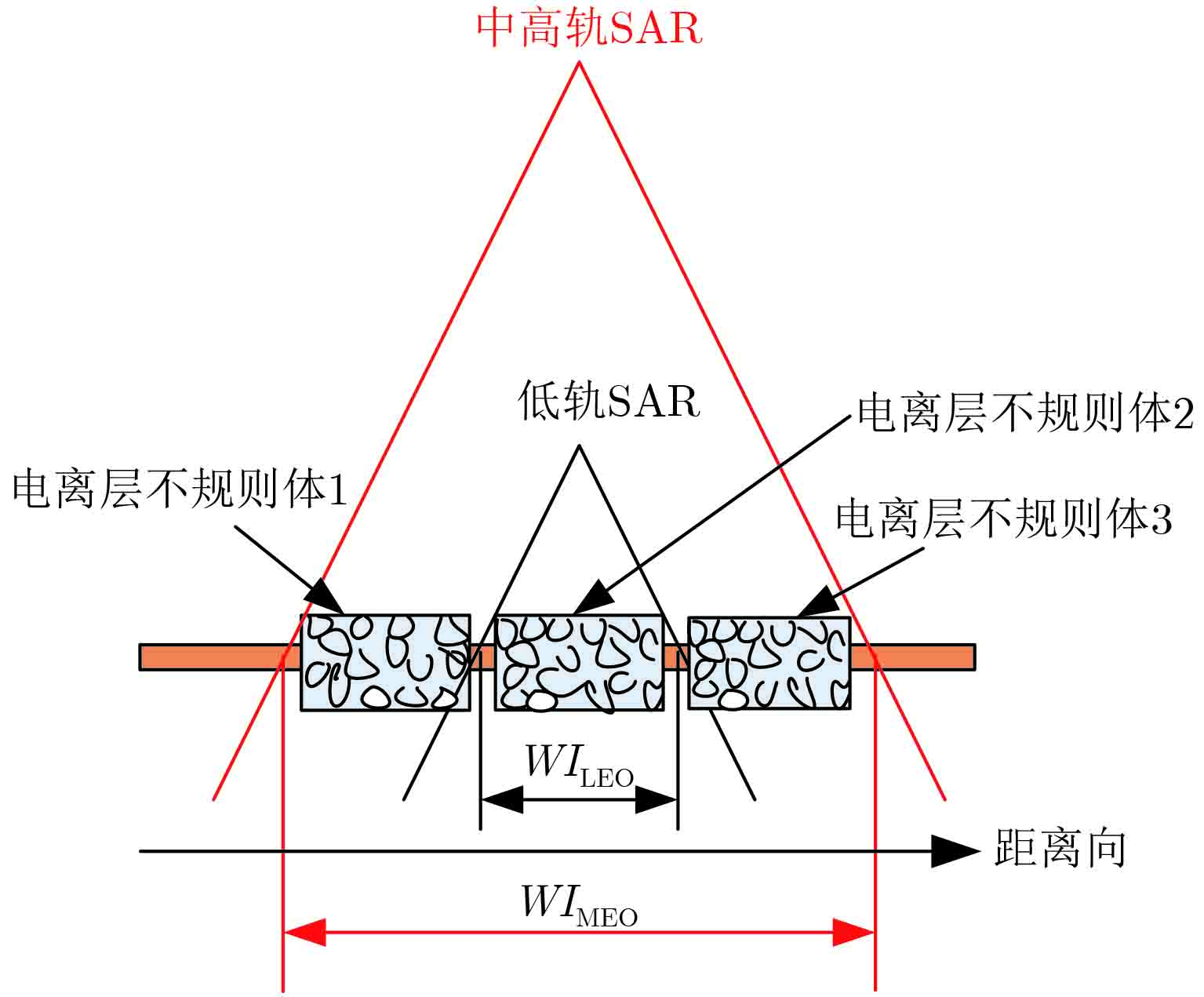
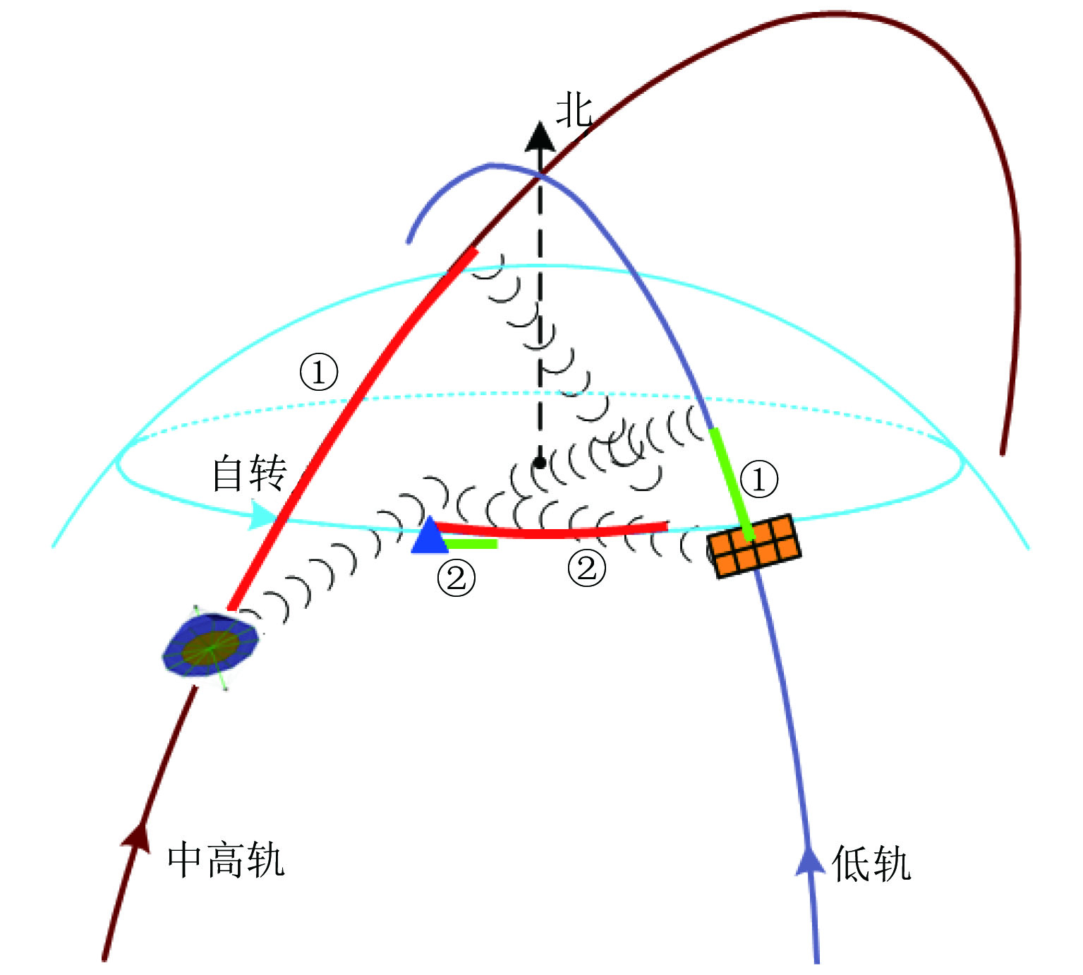
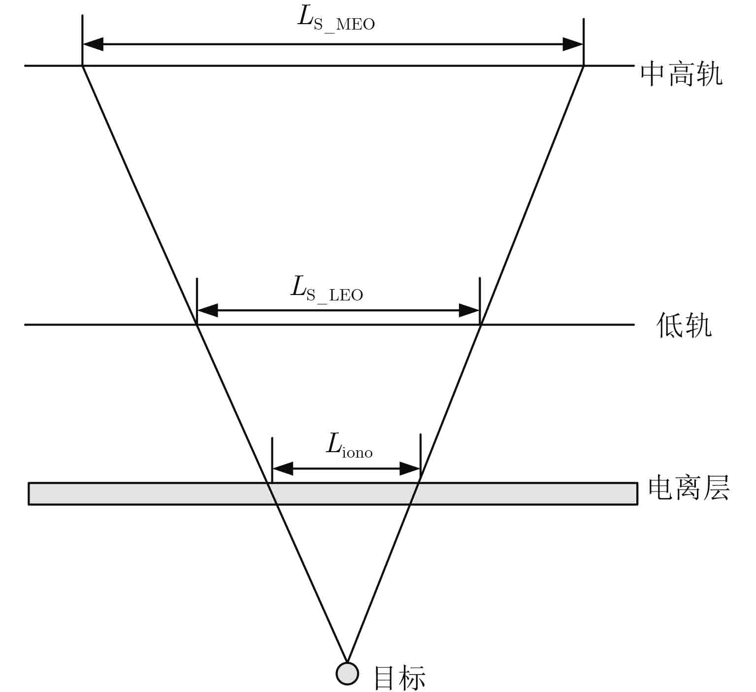
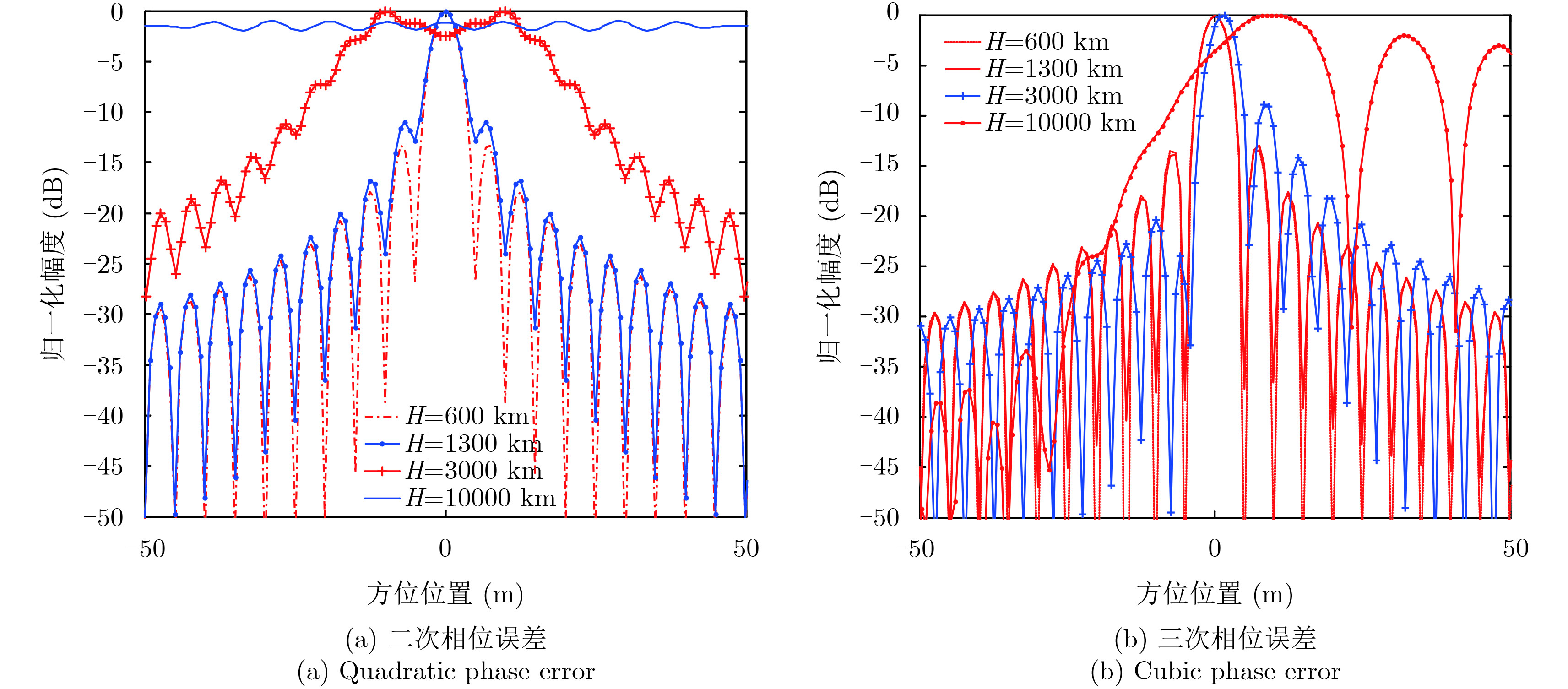
The Medium-Earth-Orbit SAR (MEOSAR) is one of the potential spaceborne SAR of next-generation owing to its excellent performance. Ionospheric effects analysis is one of the critical techniques for the development of MEOSAR. The spatio-temporal variability of the ionosphere is analyzed using the measured ionosphere data. The factors and the mechanism of ionospheric effects on MEOSAR are studied based on the spatio-temporal variability of the ionosphere and the characteristics of MEOSAR such as long synthetic aperture time, wide swath, and high orbit. The results reveal that there are many differences in the ionospheric effects between MEOSAR and LEOSAR.
The Medium-Earth-Orbit SAR (MEOSAR) is one of the potential spaceborne SAR of next-generation owing to its excellent performance. Ionospheric effects analysis is one of the critical techniques for the development of MEOSAR. The spatio-temporal variability of the ionosphere is analyzed using the measured ionosphere data. The factors and the mechanism of ionospheric effects on MEOSAR are studied based on the spatio-temporal variability of the ionosphere and the characteristics of MEOSAR such as long synthetic aperture time, wide swath, and high orbit. The results reveal that there are many differences in the ionospheric effects between MEOSAR and LEOSAR.


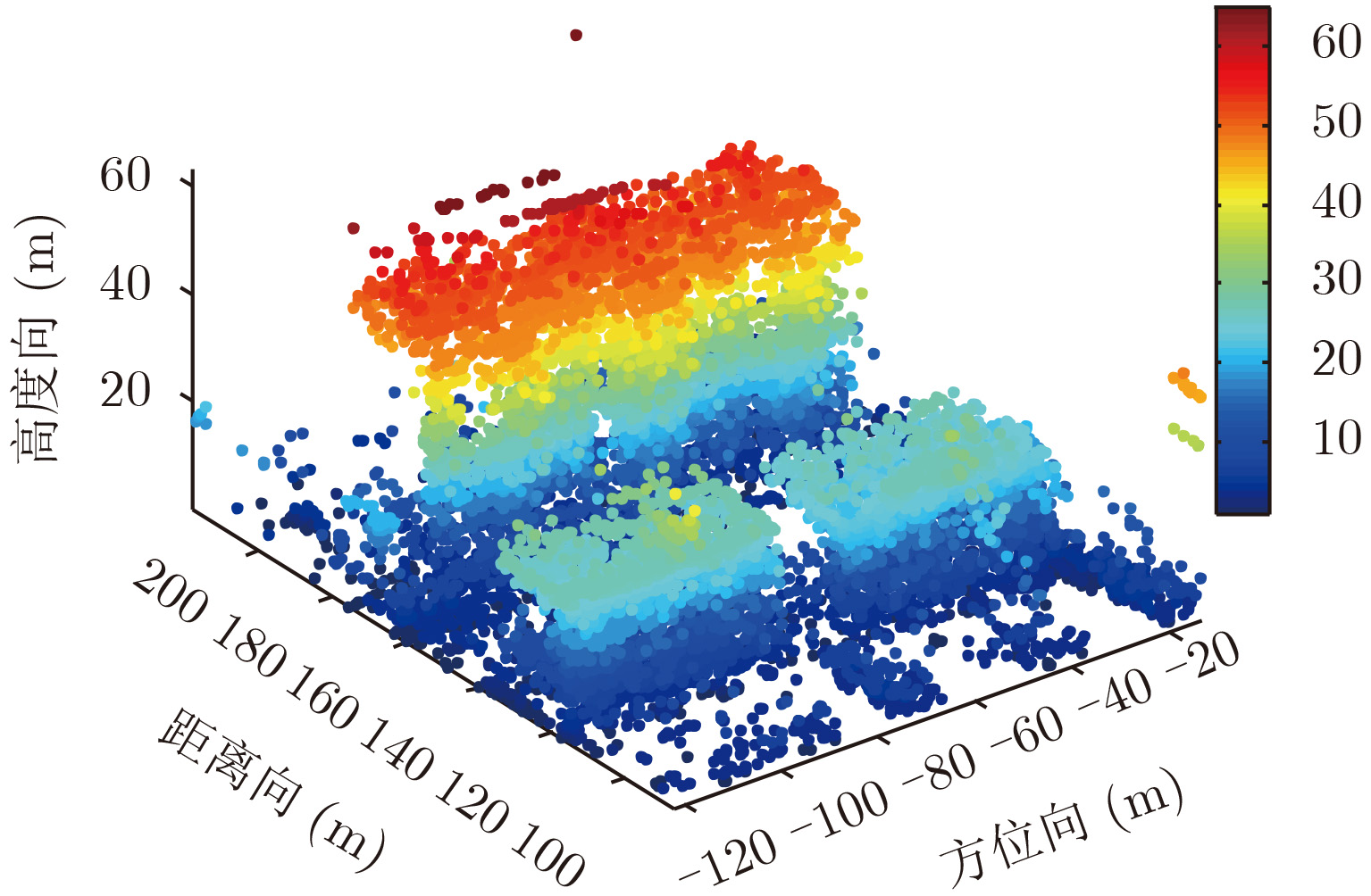
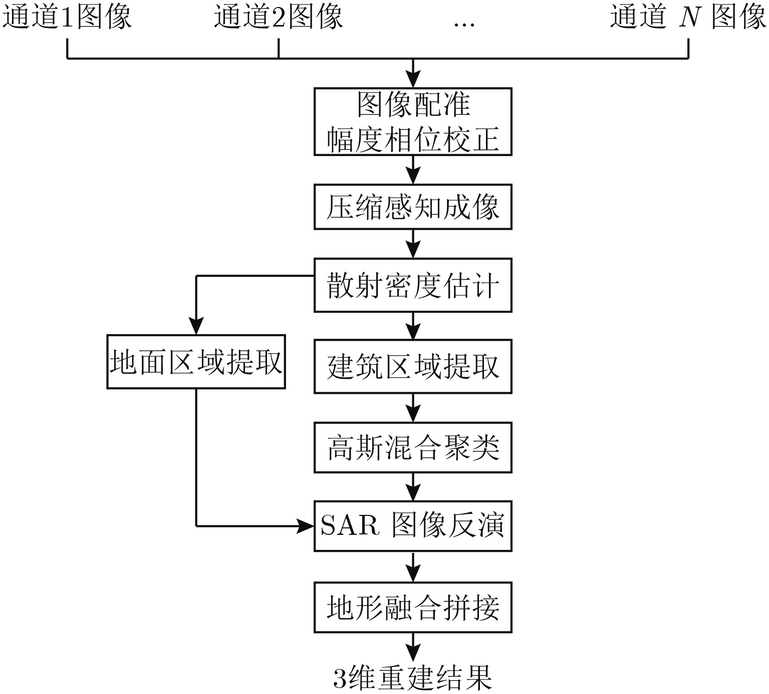
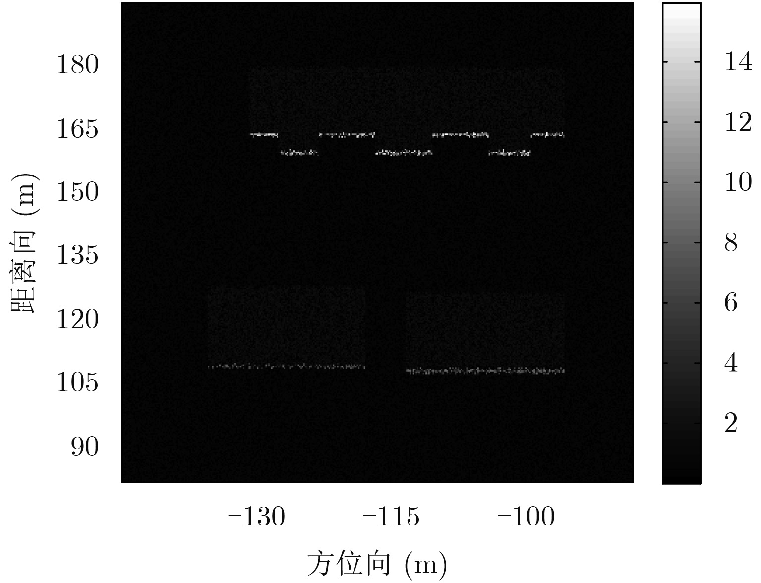
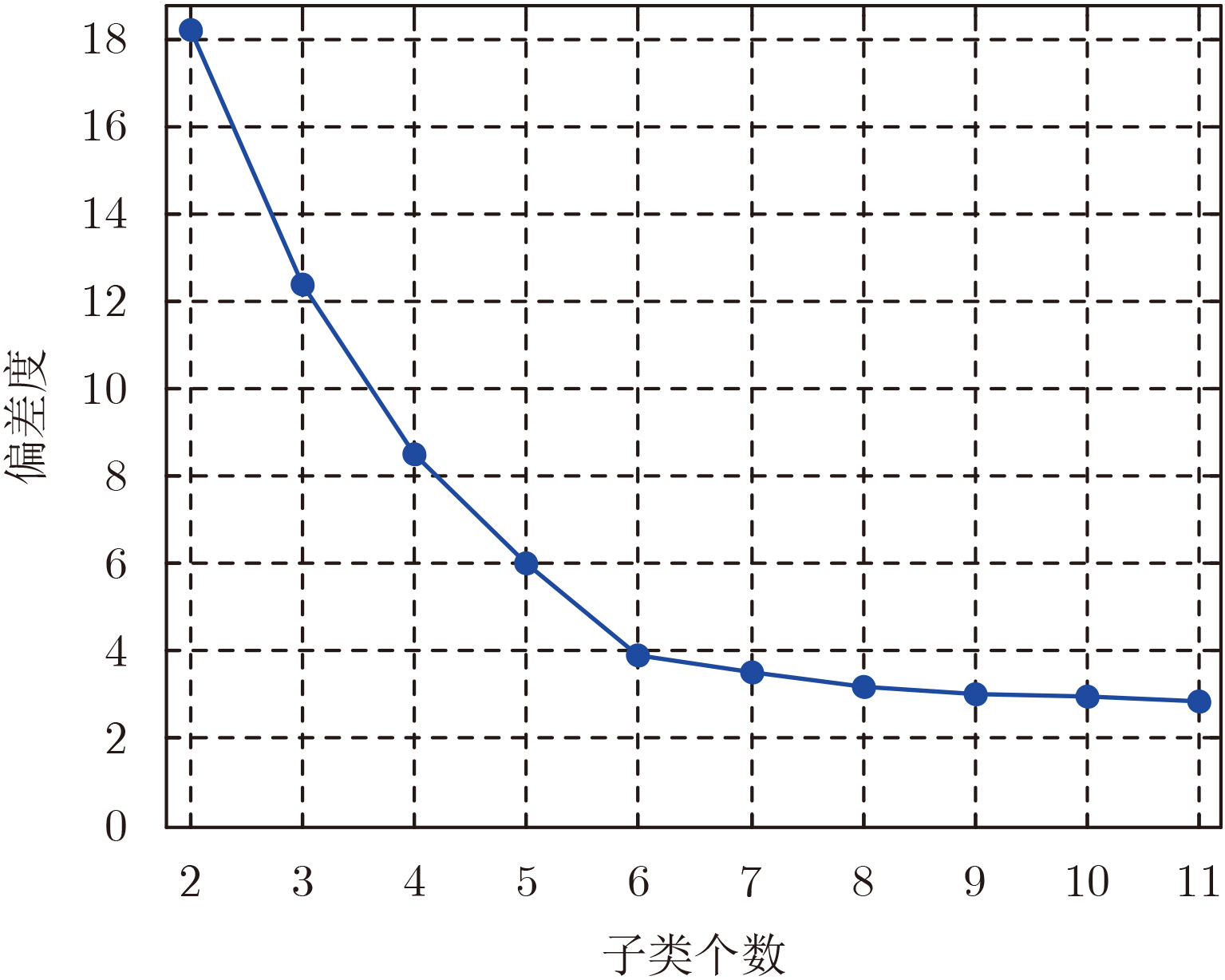
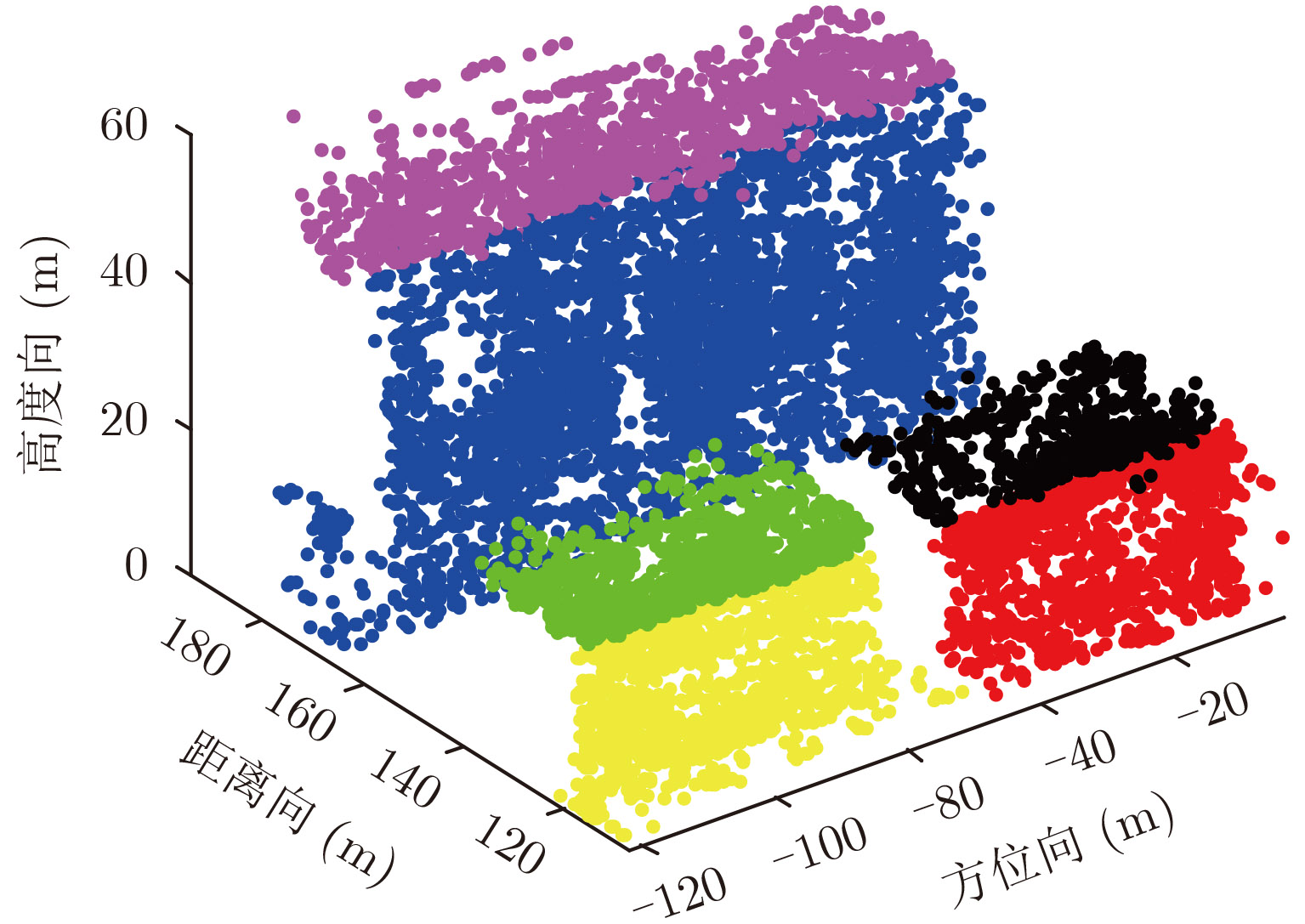
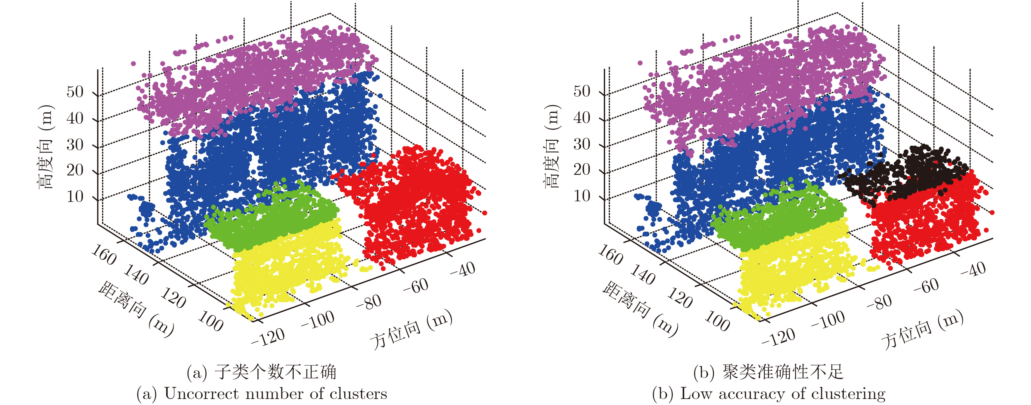
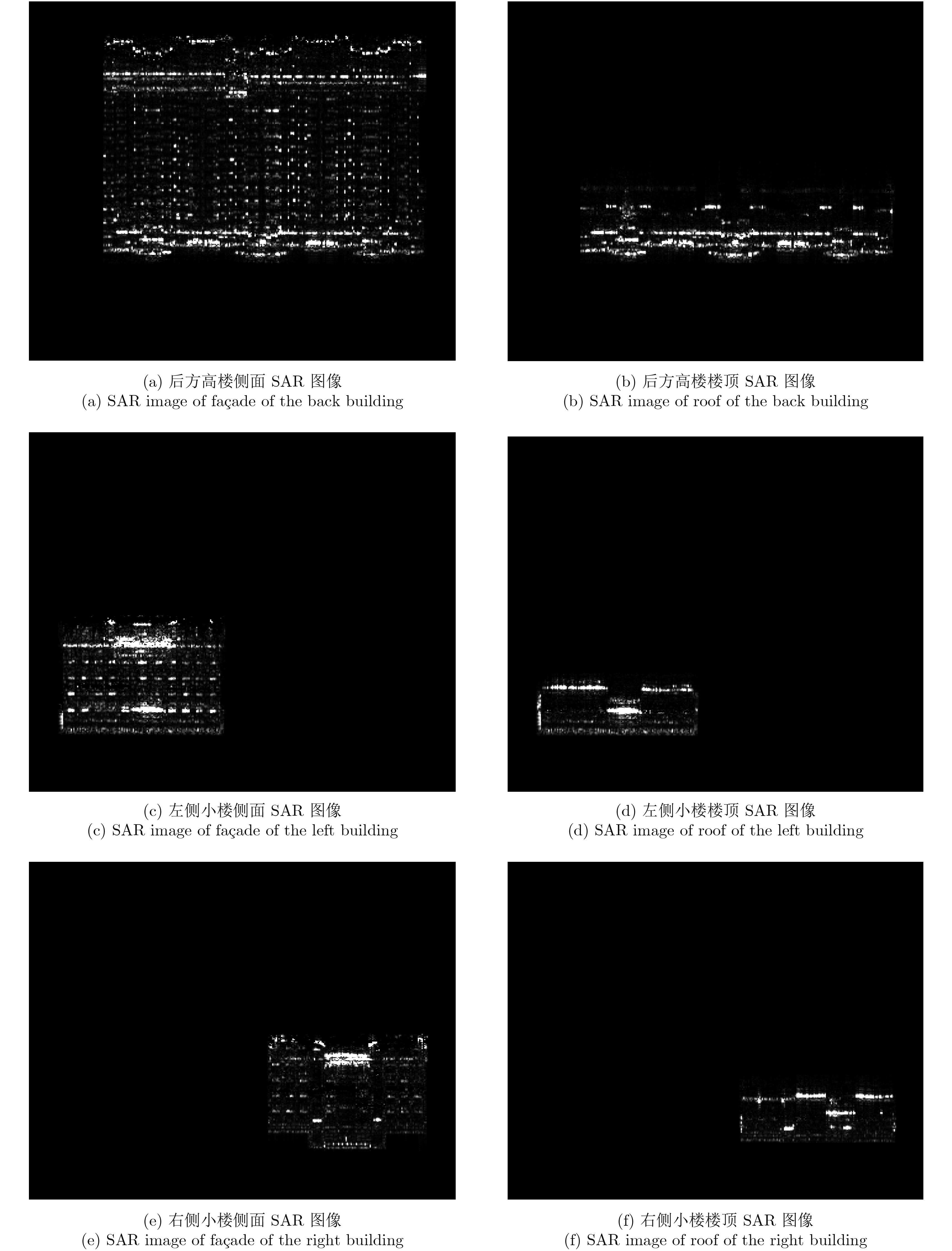
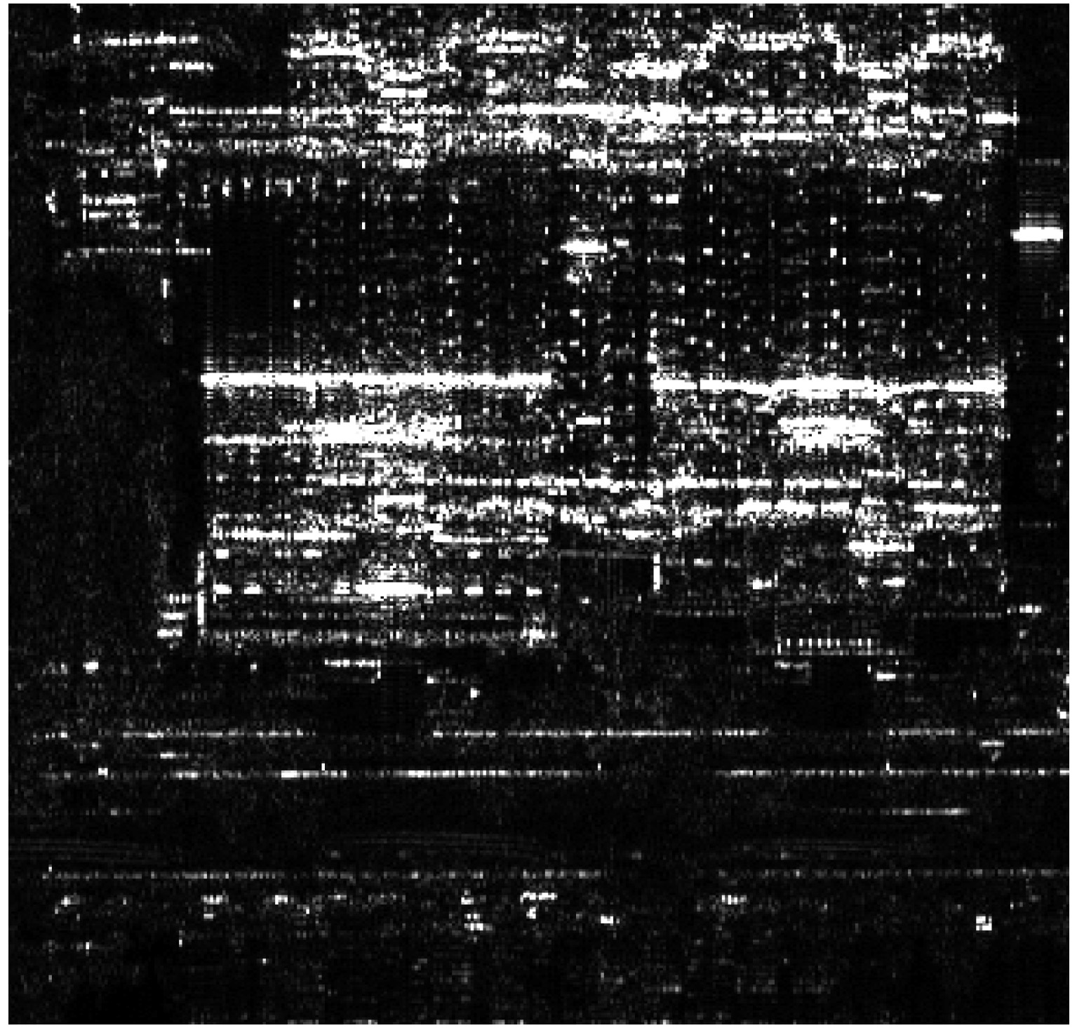
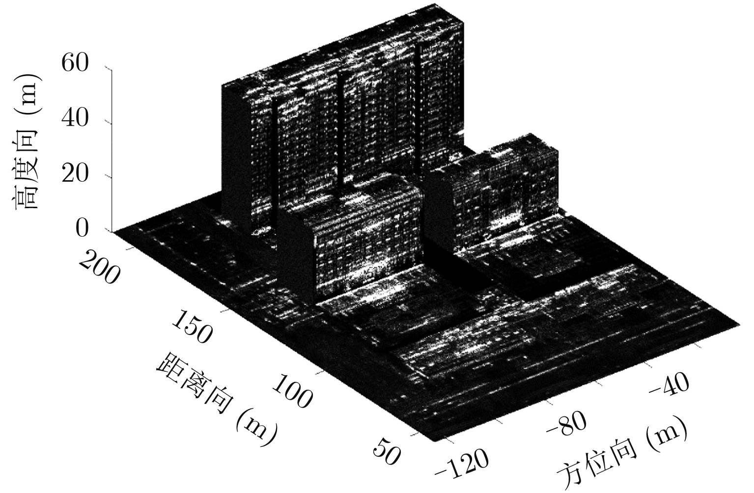
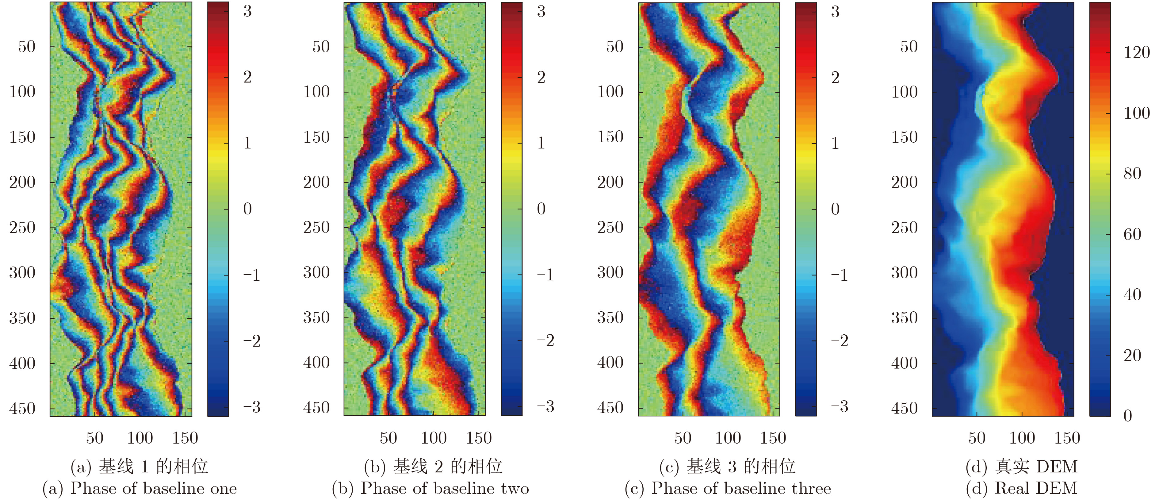
Array InSAR can generate 3D point clouds with the use of SAR images of the observed scene, which are obtained using multiple channels in a single flight. Its resolution power in elevation enables one to solve the layover problem. However, due to the limited number of arrays and the short baseline length, the resolution power in elevation is restricted. Together with the layover phenomenon of the urban buildings, the result of 3D reconstruction suffers from poor accuracy in positioning, and it is difficult to extract the effective characteristics of the buildings. In view of this situation, this paper proposed a 3D reconstruction method of array InSAR based on Gaussian mixture model clustering. First, the 3D point clouds of the observed scene are obtained by an algorithm with super-resolution based on compressive sensing, and then the scatters of buildings are extracted by density estimation; after which the method of Gaussian mixture model clustering is used to classify the 3D point clouds of the buildings. Finally, the inverse SAR images of each region are obtained by using the system parameters, and the 3D reconstruction of the buildings is completed. Based on the actual data of the first domestic 3D imaging experiment by airborne array InSAR, the validity of the algorithm is confirmed and the 3D imaging results of the buildings are obtained.
Array InSAR can generate 3D point clouds with the use of SAR images of the observed scene, which are obtained using multiple channels in a single flight. Its resolution power in elevation enables one to solve the layover problem. However, due to the limited number of arrays and the short baseline length, the resolution power in elevation is restricted. Together with the layover phenomenon of the urban buildings, the result of 3D reconstruction suffers from poor accuracy in positioning, and it is difficult to extract the effective characteristics of the buildings. In view of this situation, this paper proposed a 3D reconstruction method of array InSAR based on Gaussian mixture model clustering. First, the 3D point clouds of the observed scene are obtained by an algorithm with super-resolution based on compressive sensing, and then the scatters of buildings are extracted by density estimation; after which the method of Gaussian mixture model clustering is used to classify the 3D point clouds of the buildings. Finally, the inverse SAR images of each region are obtained by using the system parameters, and the 3D reconstruction of the buildings is completed. Based on the actual data of the first domestic 3D imaging experiment by airborne array InSAR, the validity of the algorithm is confirmed and the 3D imaging results of the buildings are obtained.


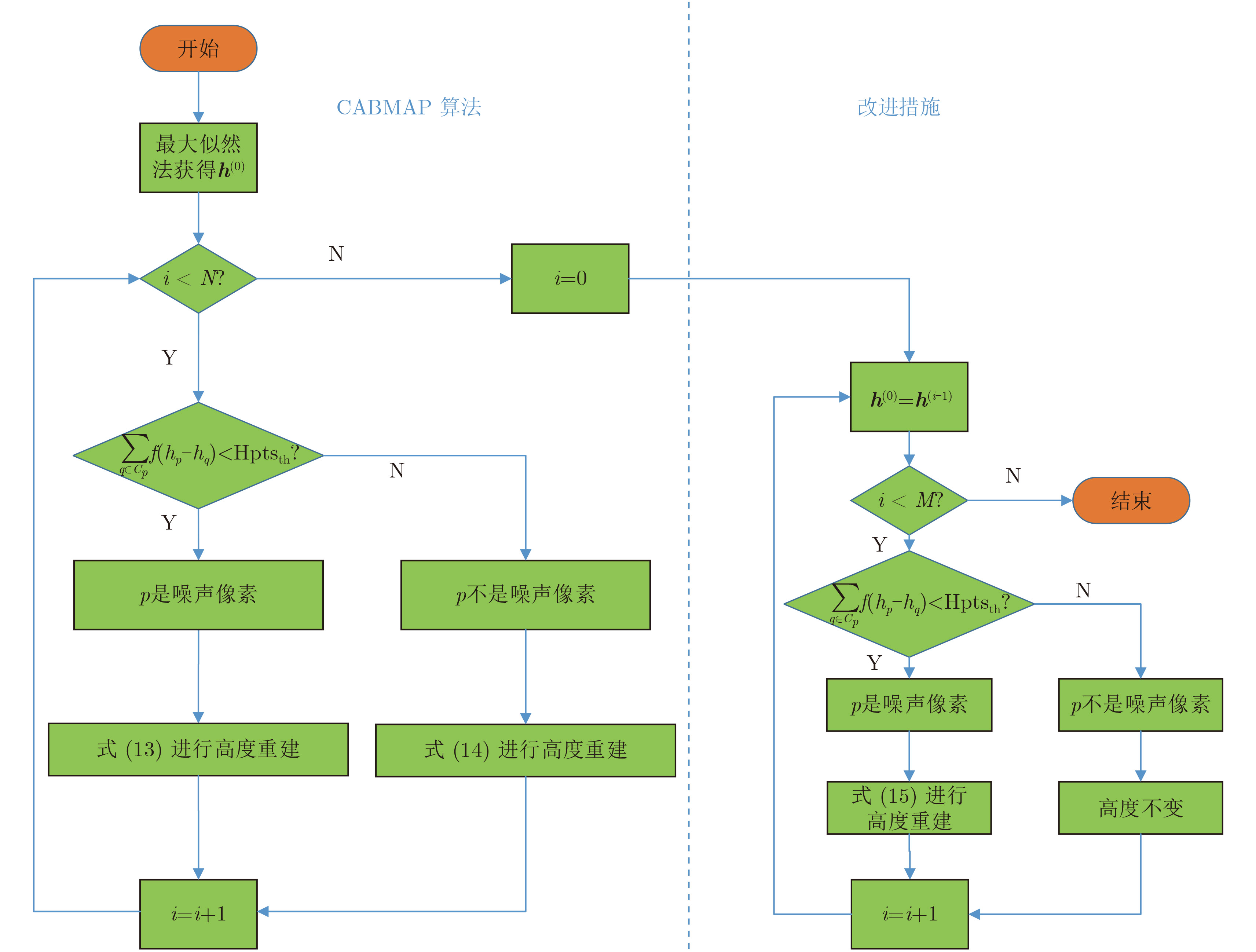
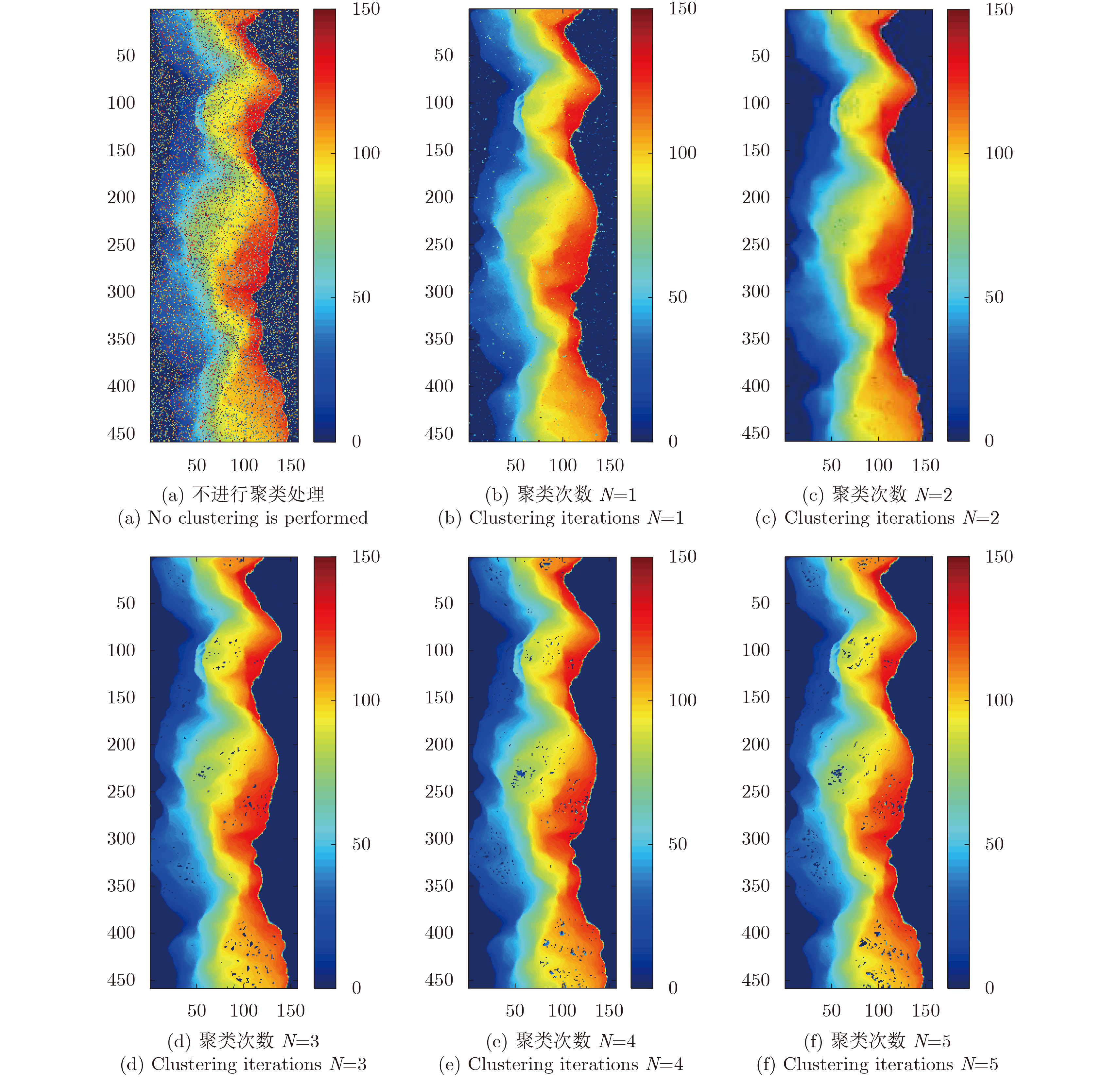
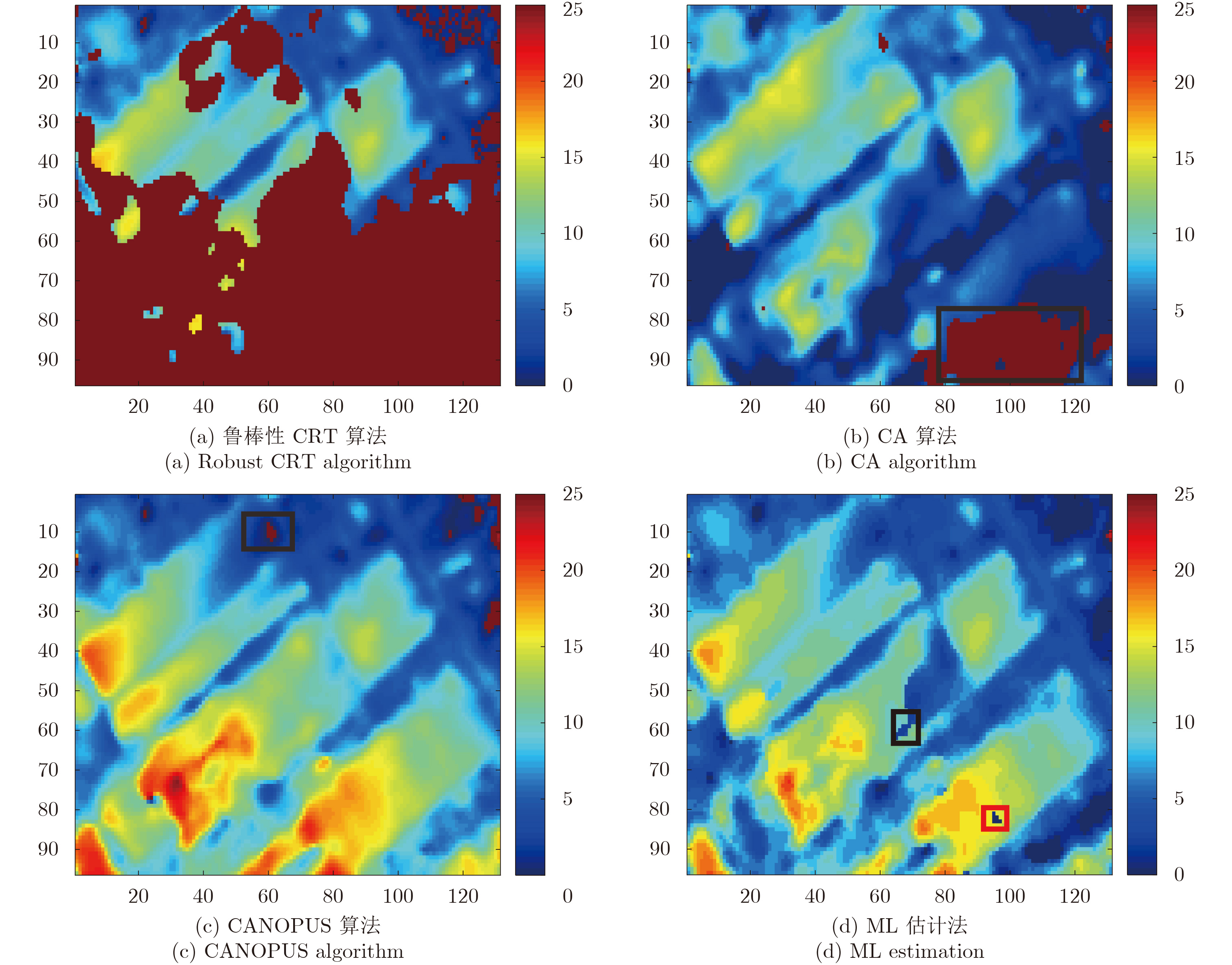
The multi-baseline InSAR can effectively reduce the adverse effect caused by the abrupt change of the target and the large noise disturbance and can obtain the Digital Elevation Model (DEM) that is more accurate than the single baseline InSAR. Traditional multi-baseline height reconstruction algorithm based on Maximum Likelihood (ML) estimation is poorly reconstructed in the case of fewer channels, and the height reconstruction algorithm based on Maximum A Posteriori estimation (MAP) has a long runtime defect; to solve this problem, this study proposes the cluster analysis based on maximum a posteriori algorithm. This algorithm uses the ML estimation to obtain a rough DEM. Based on this result, the noise pixels in the neighborhood in each iteration process are determined by cluster analysis. Finally, through the calculation of posterior probability to complete the reconstruction, an optimized method is adopted to improve the accuracy. Experiments reveal that the algorithm retains the speed of the ML method as well as the high precision of the MAP estimation, thus maintaining accuracy and high operating efficiency.
The multi-baseline InSAR can effectively reduce the adverse effect caused by the abrupt change of the target and the large noise disturbance and can obtain the Digital Elevation Model (DEM) that is more accurate than the single baseline InSAR. Traditional multi-baseline height reconstruction algorithm based on Maximum Likelihood (ML) estimation is poorly reconstructed in the case of fewer channels, and the height reconstruction algorithm based on Maximum A Posteriori estimation (MAP) has a long runtime defect; to solve this problem, this study proposes the cluster analysis based on maximum a posteriori algorithm. This algorithm uses the ML estimation to obtain a rough DEM. Based on this result, the noise pixels in the neighborhood in each iteration process are determined by cluster analysis. Finally, through the calculation of posterior probability to complete the reconstruction, an optimized method is adopted to improve the accuracy. Experiments reveal that the algorithm retains the speed of the ML method as well as the high precision of the MAP estimation, thus maintaining accuracy and high operating efficiency.


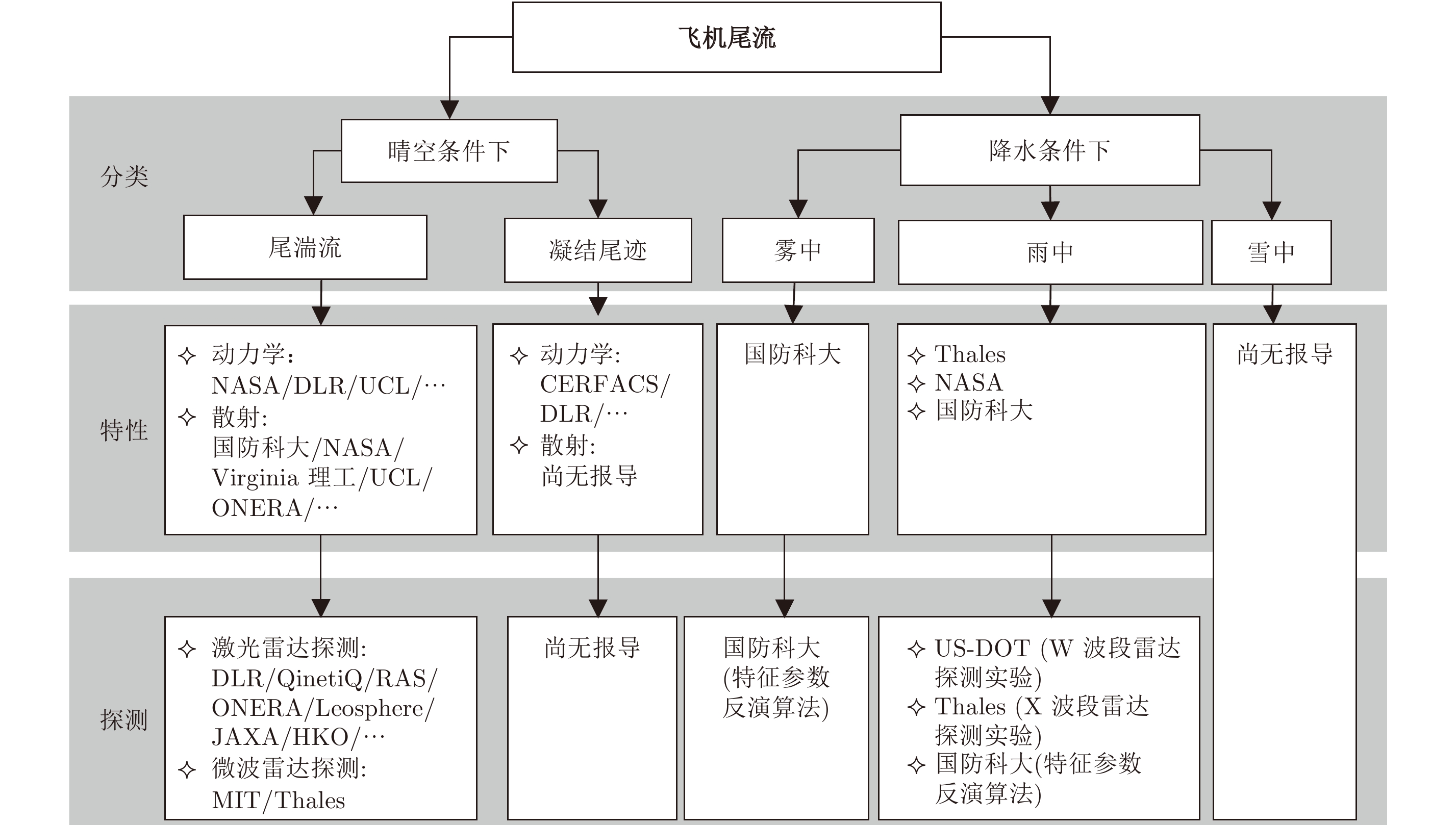
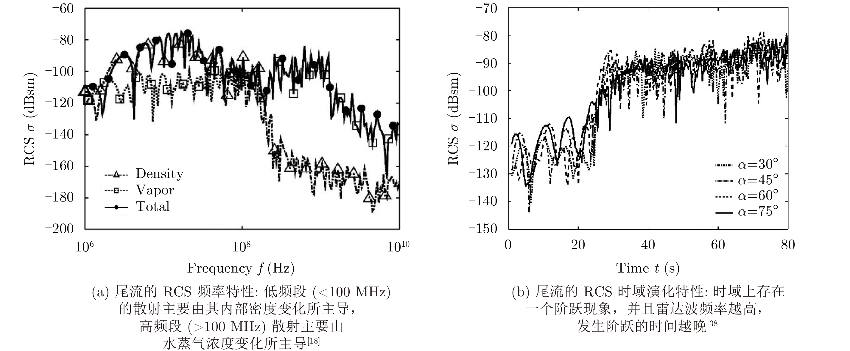
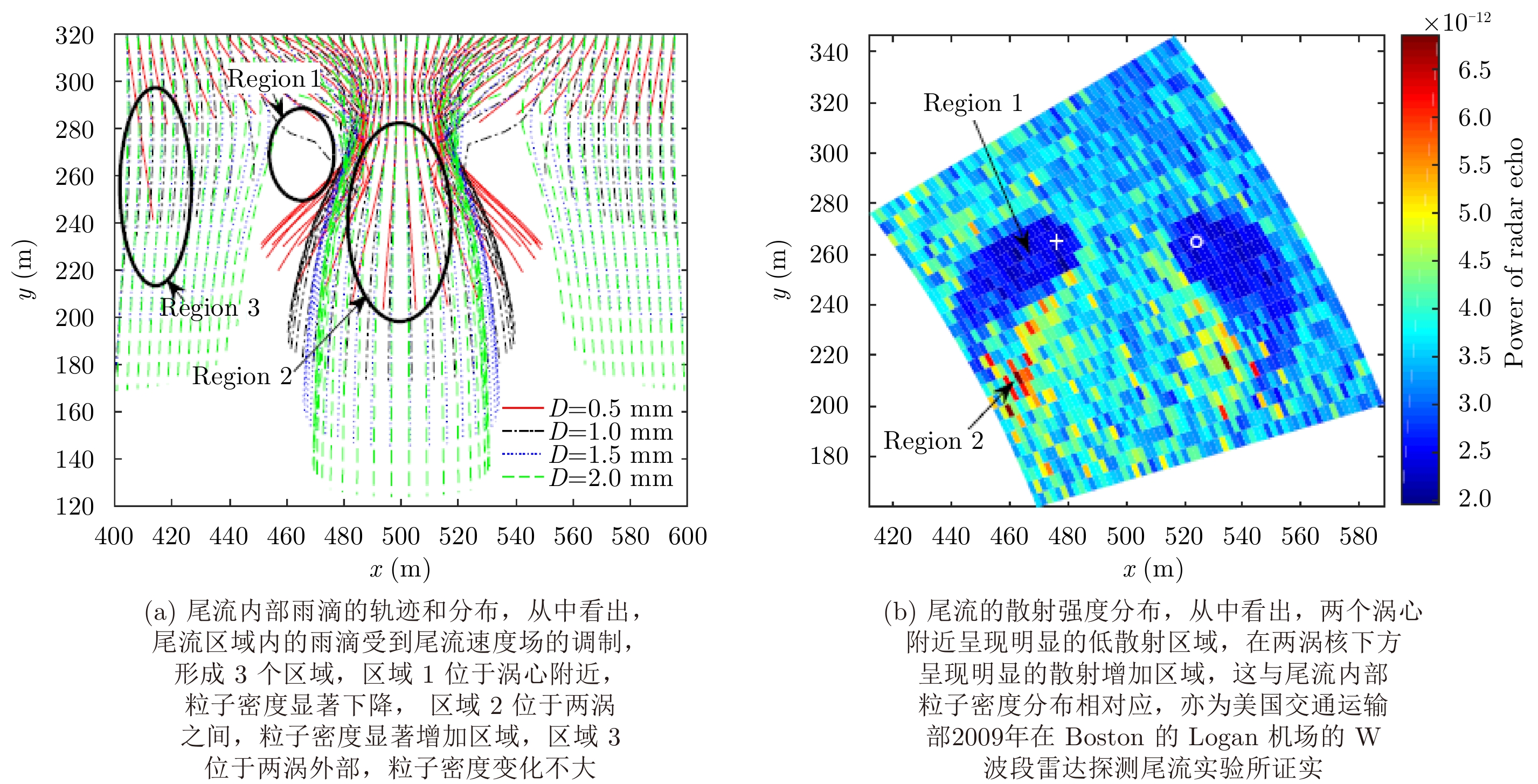
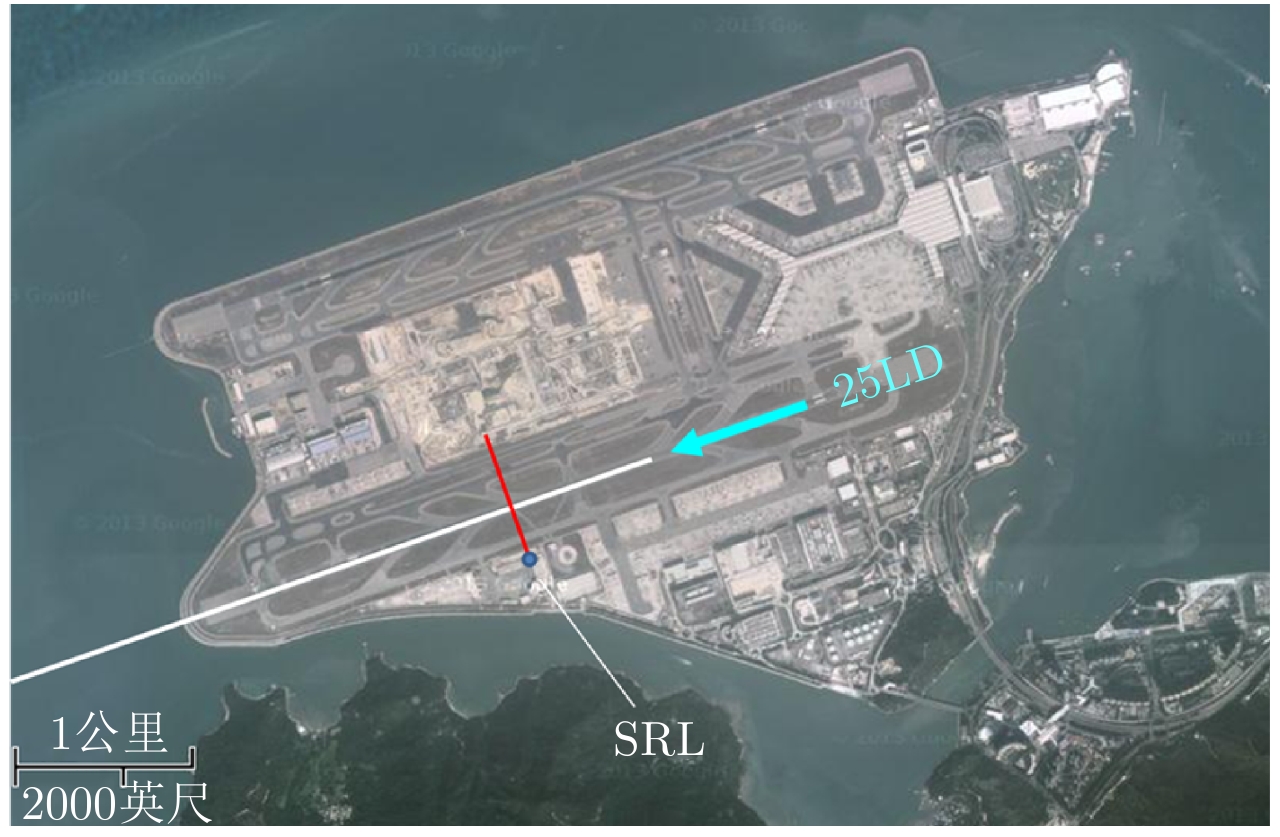
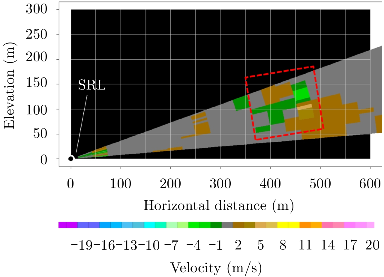
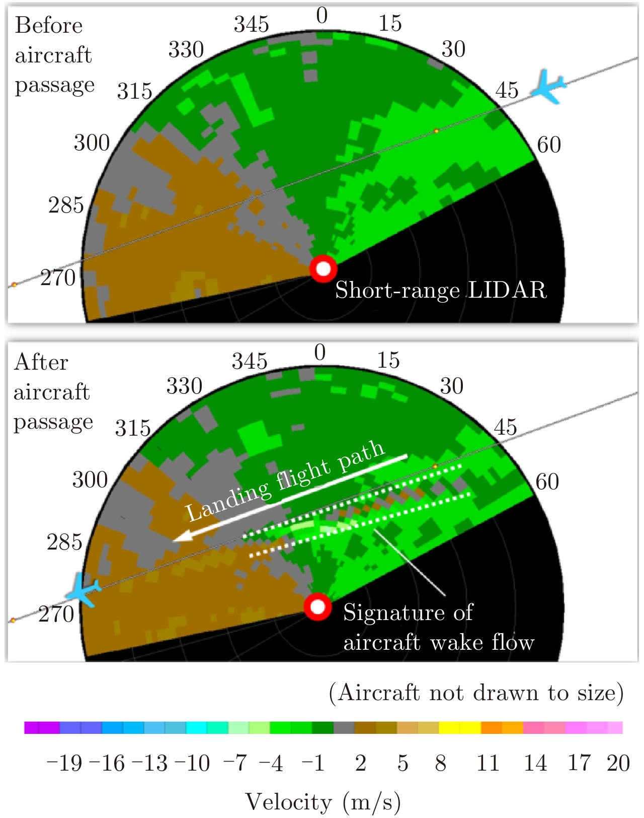
Aircraft wake vortex is a pair of strong counter-rotating vortices and has attracted considerable attention in various fields including aviation safety and atmospheric physics. The characteristics and detection of wake vortex act as the basis for both behavior prediction as well as hazard assessment. This paper provides a short survey of the characteristics and detection researches. Initially, the wake vortex is classified as clear-air wake vortex (i.e., wake turbulence and contrail) and precipitation wake vortex (i.e., under rainy, foggy or snowy condition). Subsequently, the dynamics and scattering are introduced, and the main verdicts are: the radar (radio detection and ranging) scattering of wake vortex is relatively weak under clear air conditions, but the Lidar (Light detection and ranging) scattering is appreciable owing to the presence of particles such as aerosols. Wake vortices under precipitation conditions and contrails possess relatively good radar reflectivity owing the strong scattering characteristics of precipitation droplets and ice crystals. Furthermore, we have introduced a joint detection scheme of Lidar and radar for wake vortex along with parameter-retrieval algorithms. Finally, we have presented our conclusions and intended future research.
Aircraft wake vortex is a pair of strong counter-rotating vortices and has attracted considerable attention in various fields including aviation safety and atmospheric physics. The characteristics and detection of wake vortex act as the basis for both behavior prediction as well as hazard assessment. This paper provides a short survey of the characteristics and detection researches. Initially, the wake vortex is classified as clear-air wake vortex (i.e., wake turbulence and contrail) and precipitation wake vortex (i.e., under rainy, foggy or snowy condition). Subsequently, the dynamics and scattering are introduced, and the main verdicts are: the radar (radio detection and ranging) scattering of wake vortex is relatively weak under clear air conditions, but the Lidar (Light detection and ranging) scattering is appreciable owing to the presence of particles such as aerosols. Wake vortices under precipitation conditions and contrails possess relatively good radar reflectivity owing the strong scattering characteristics of precipitation droplets and ice crystals. Furthermore, we have introduced a joint detection scheme of Lidar and radar for wake vortex along with parameter-retrieval algorithms. Finally, we have presented our conclusions and intended future research.


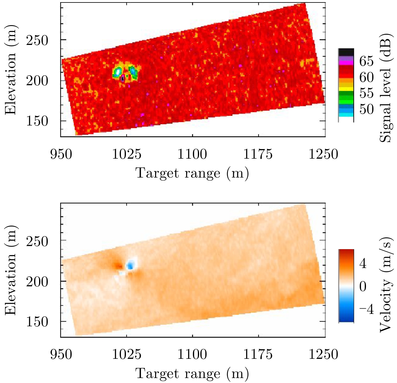
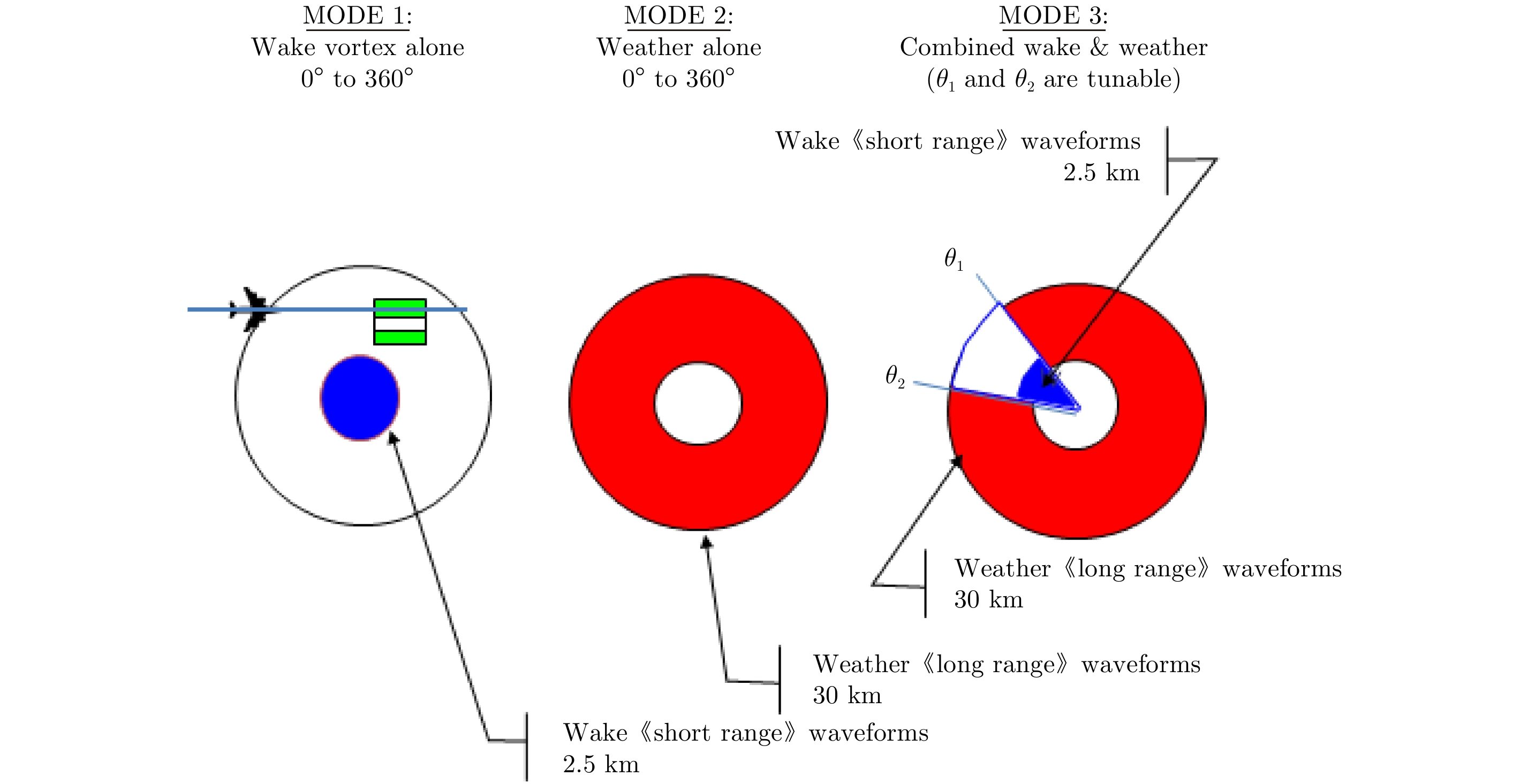
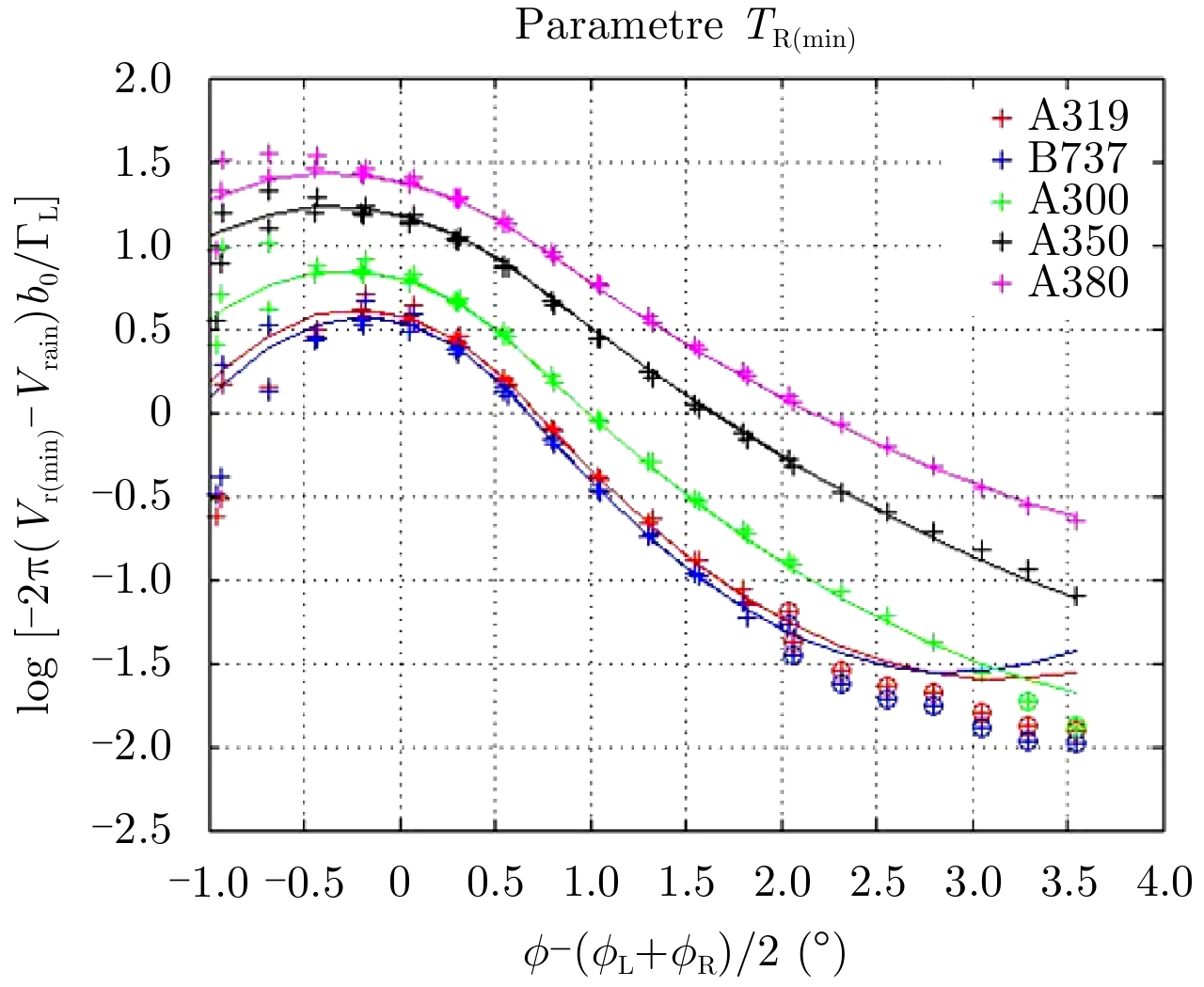
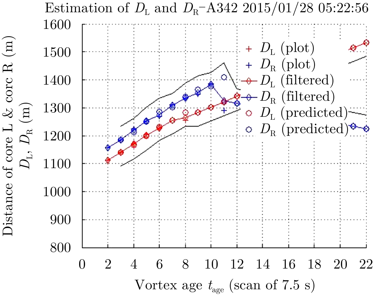
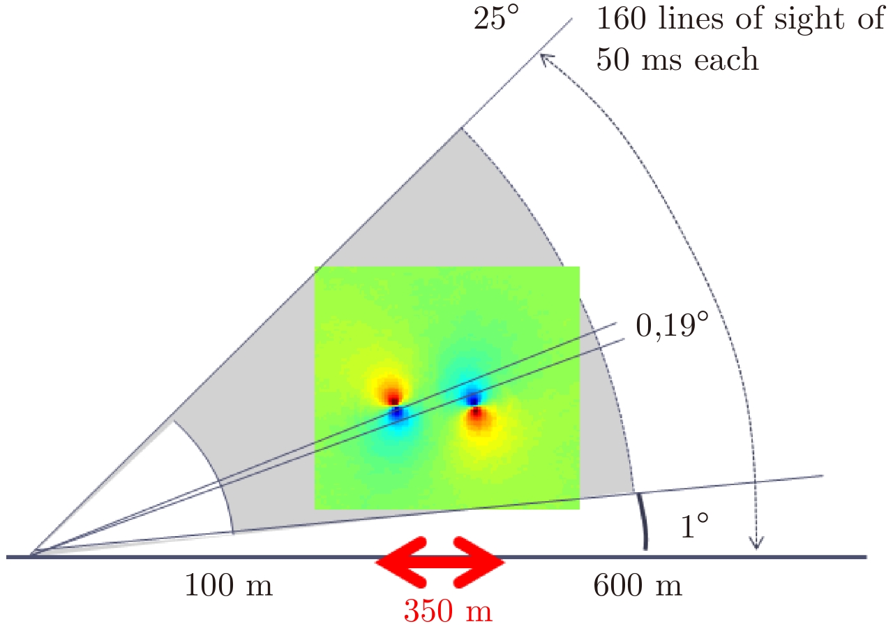
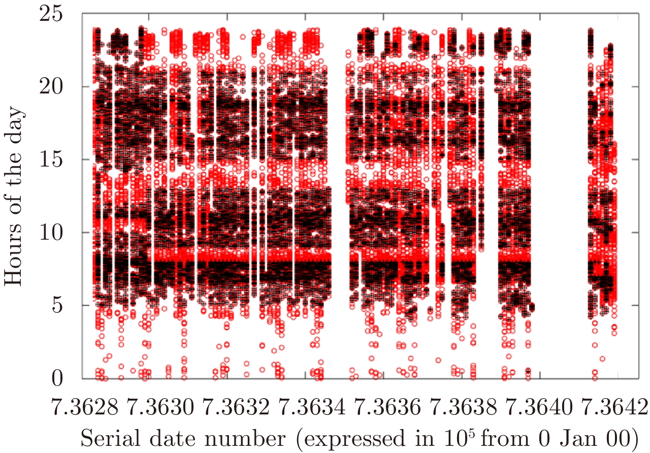
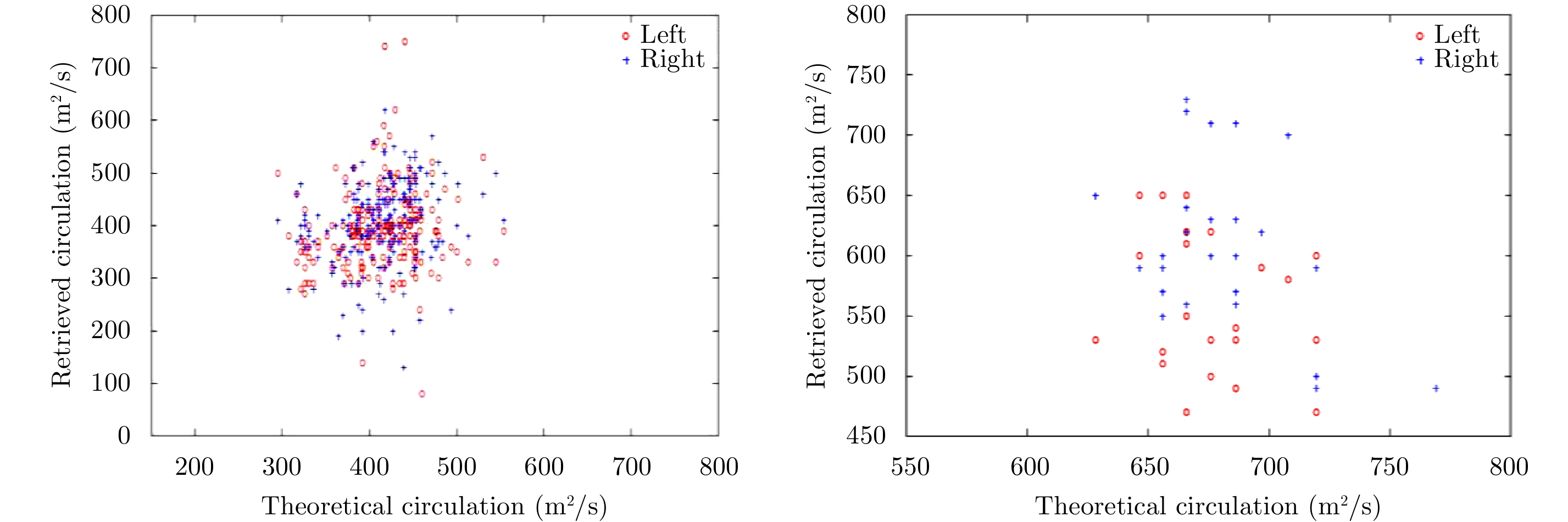
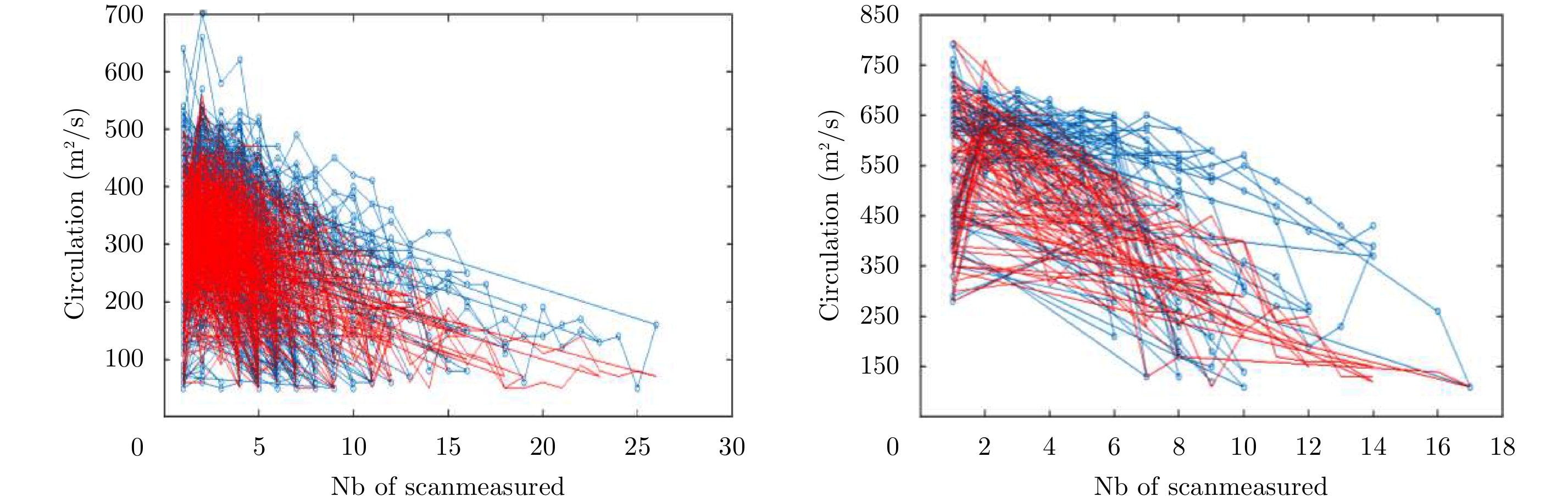
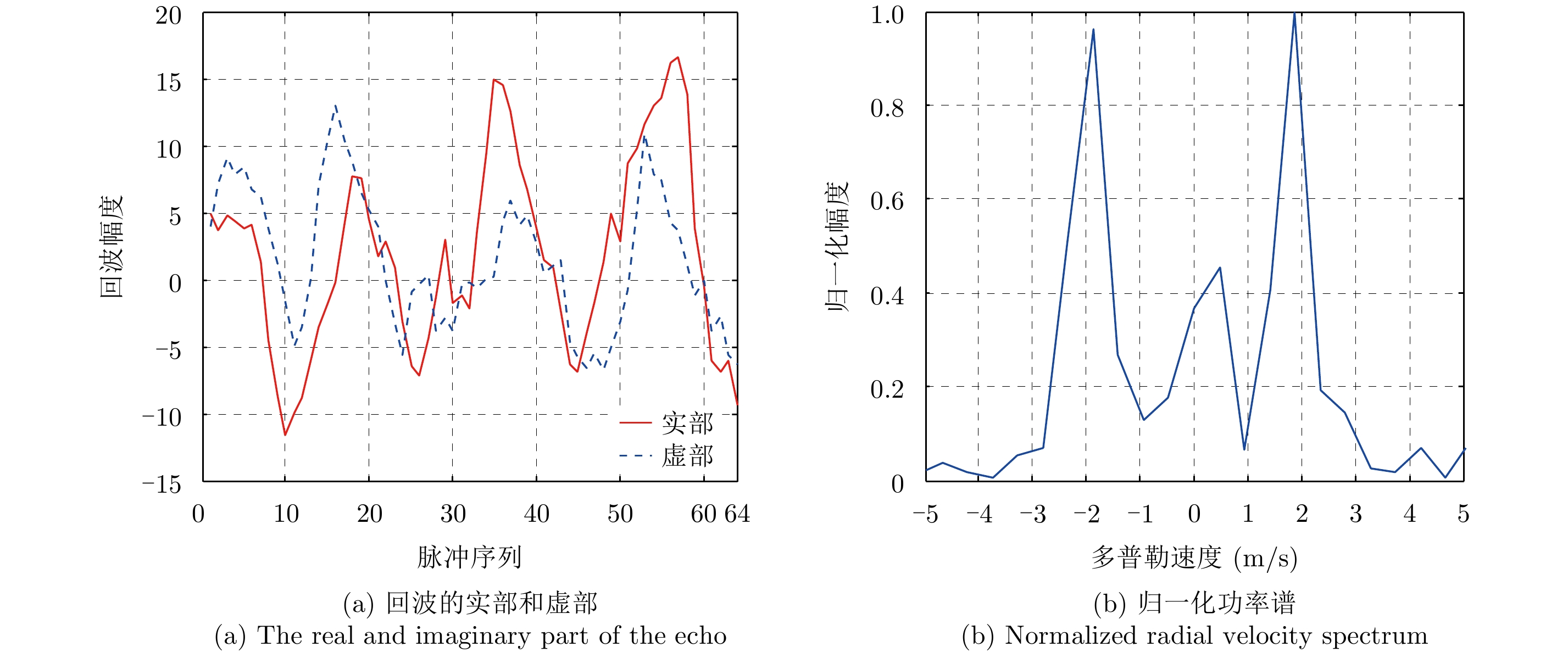
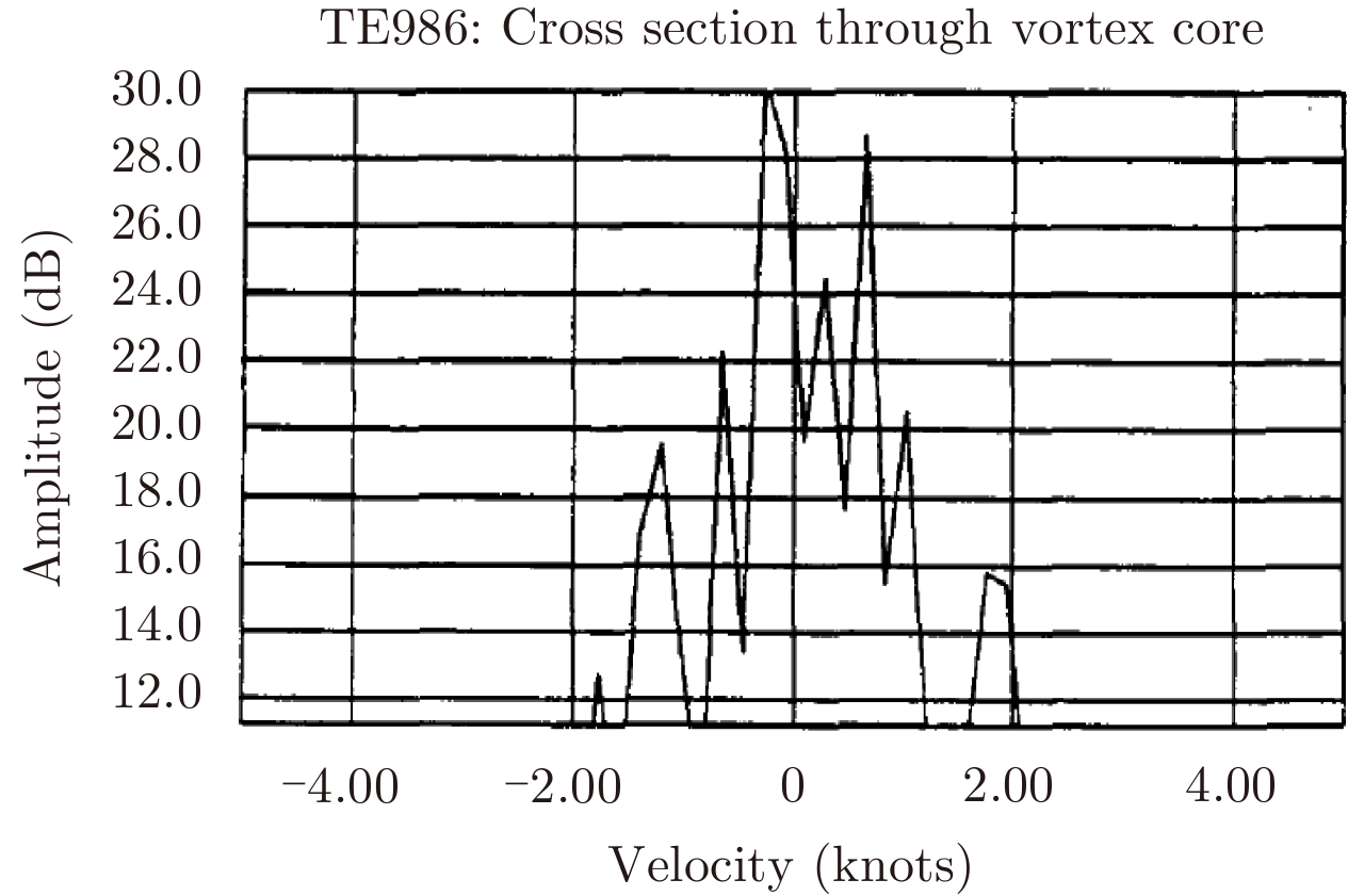
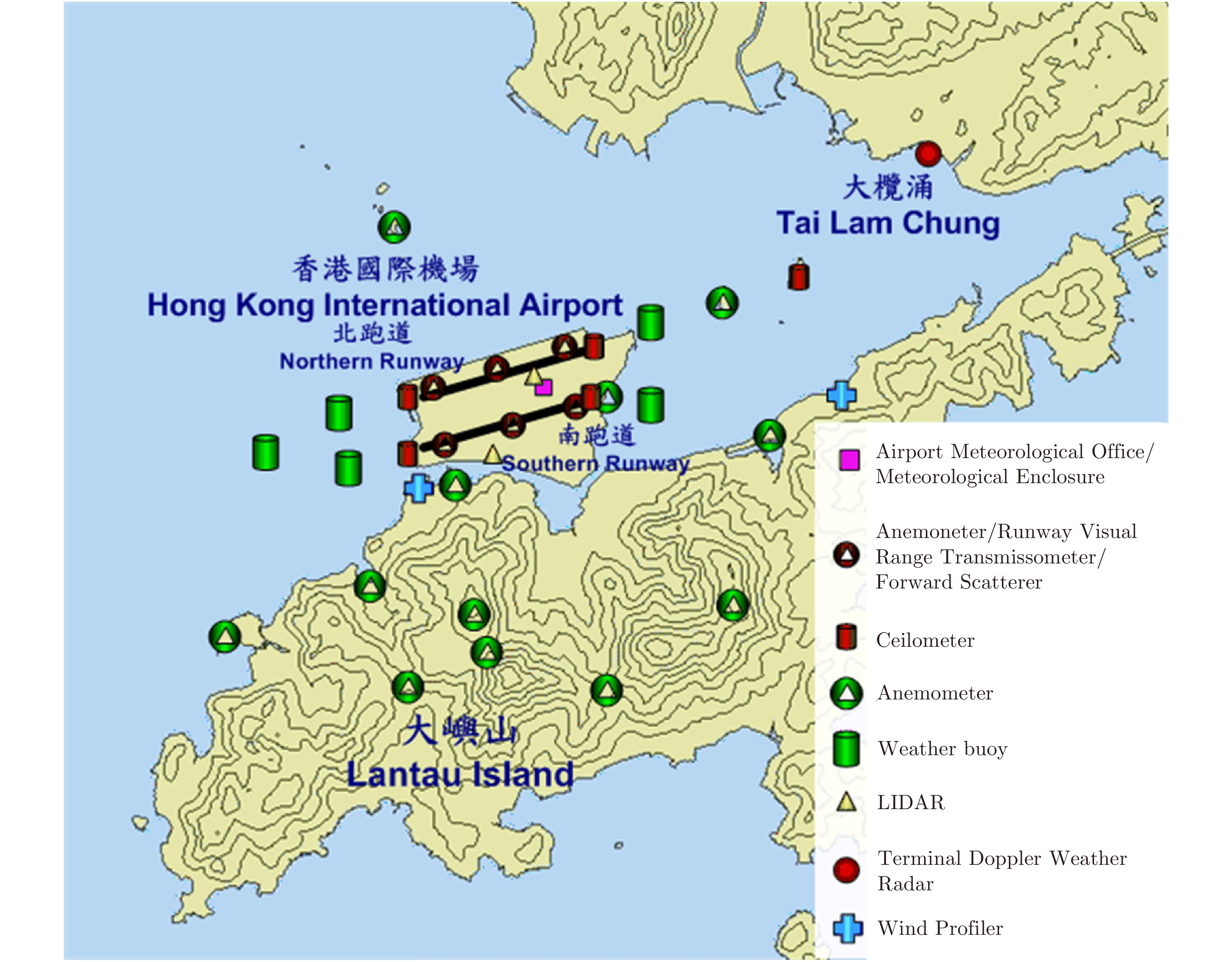
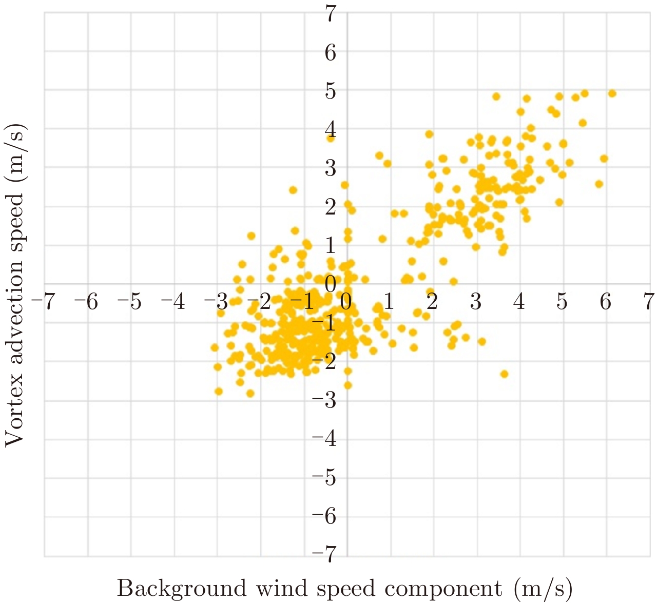
At airports, runway operation is the limiting factor for the overall throughput; specifically the fixed and overly conservative ICAO wake turbulence separation minima. The wake turbulence hazardous flows can dissipate quicker because of decay due to air turbulence or be transported out of the way on oncoming traffic by cross-wind, yet wake turbulence separation minima do not take into account wind conditions. Indeed, for safety reasons, most airports assume a worst-case scenario and use conservative separations; the interval between aircraft taking off or landing therefore often amounts to several minutes. However, with the aid of accurate wind data and precise measurements of wake vortex by radar sensors, more efficient intervals can be set, particularly when weather conditions are stable. Depending on traffic volume, these adjustments can generate capacity gains, which have major commercial benefits. This paper presents the use of Electronic scanning radar for detecting wake vortices. In this method, the raindrops Doppler spectrogram is used to retrieve the strength of the wake vortex. Numerical simulation are performed to establish an empirical model used during the retrieval method. This paper presents also the results obtained during the trials of the PARIS-CDG data set recorded from October 2014 to November 2015 with an X-band RADAR developed and deployed by THALES.
At airports, runway operation is the limiting factor for the overall throughput; specifically the fixed and overly conservative ICAO wake turbulence separation minima. The wake turbulence hazardous flows can dissipate quicker because of decay due to air turbulence or be transported out of the way on oncoming traffic by cross-wind, yet wake turbulence separation minima do not take into account wind conditions. Indeed, for safety reasons, most airports assume a worst-case scenario and use conservative separations; the interval between aircraft taking off or landing therefore often amounts to several minutes. However, with the aid of accurate wind data and precise measurements of wake vortex by radar sensors, more efficient intervals can be set, particularly when weather conditions are stable. Depending on traffic volume, these adjustments can generate capacity gains, which have major commercial benefits. This paper presents the use of Electronic scanning radar for detecting wake vortices. In this method, the raindrops Doppler spectrogram is used to retrieve the strength of the wake vortex. Numerical simulation are performed to establish an empirical model used during the retrieval method. This paper presents also the results obtained during the trials of the PARIS-CDG data set recorded from October 2014 to November 2015 with an X-band RADAR developed and deployed by THALES.


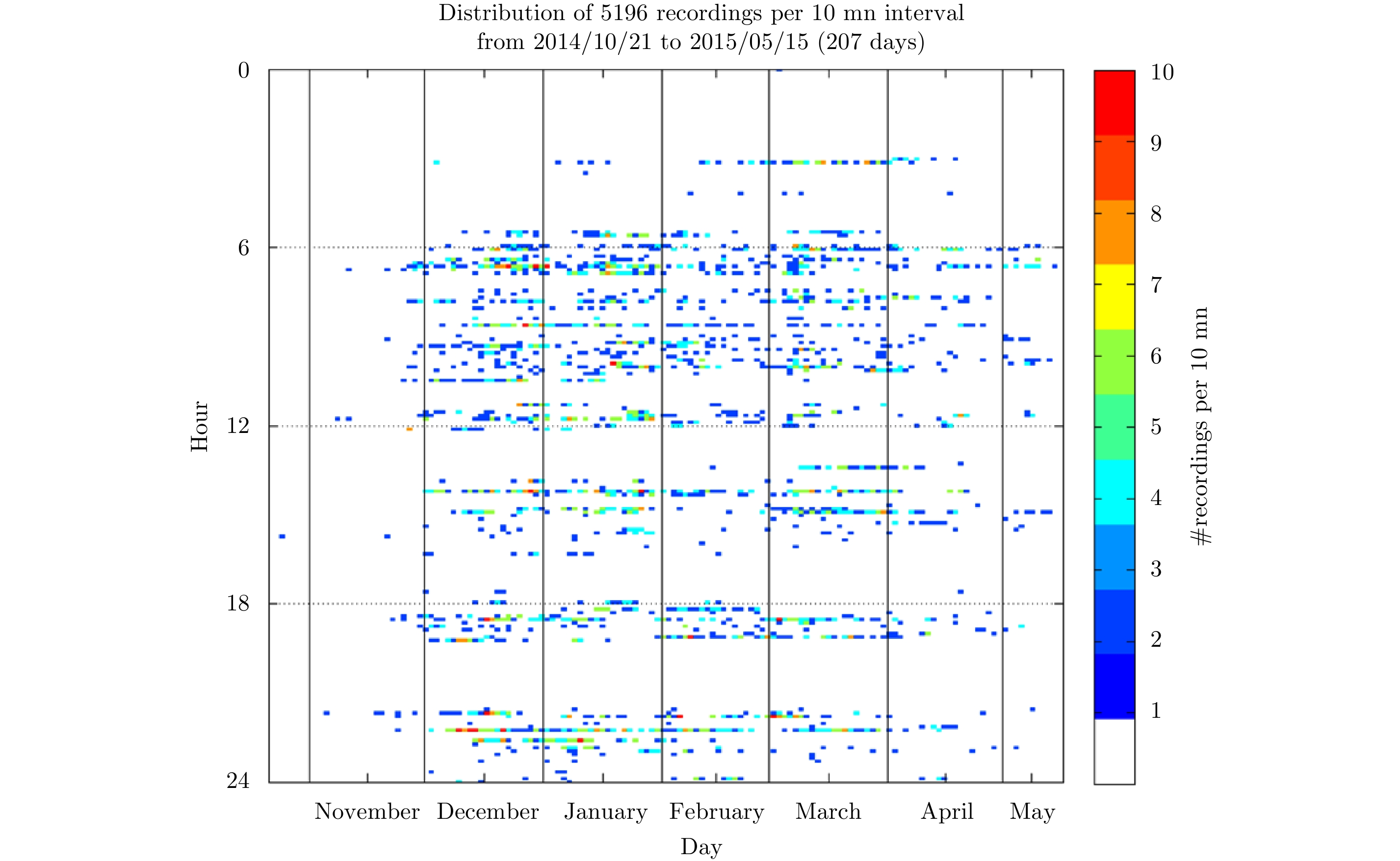
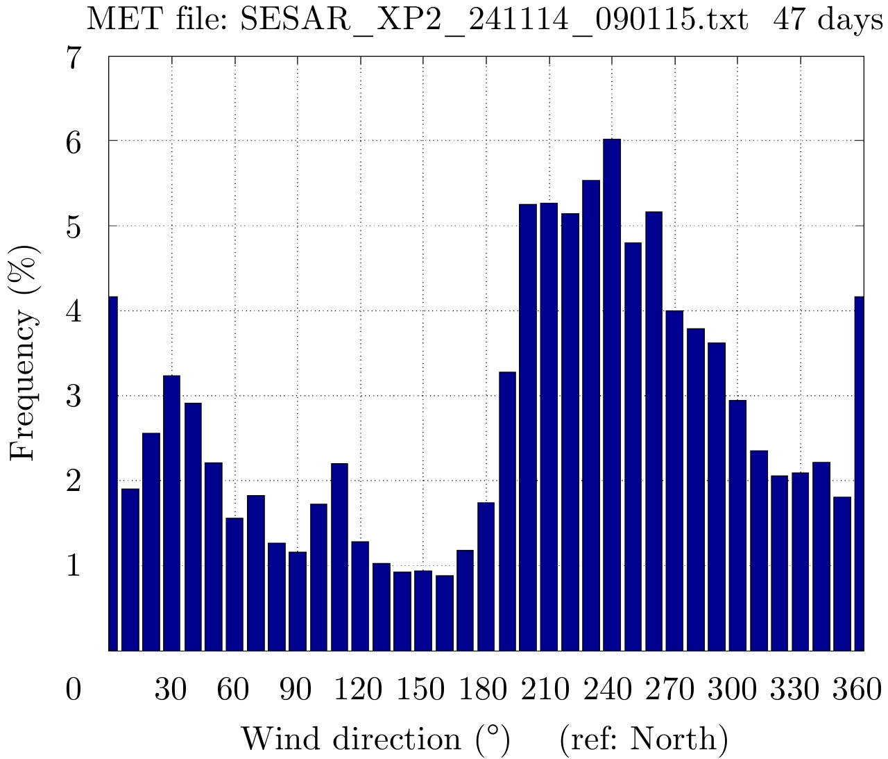
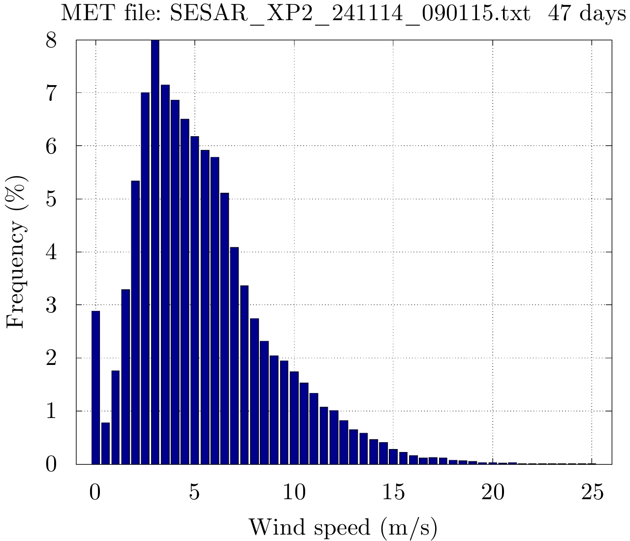


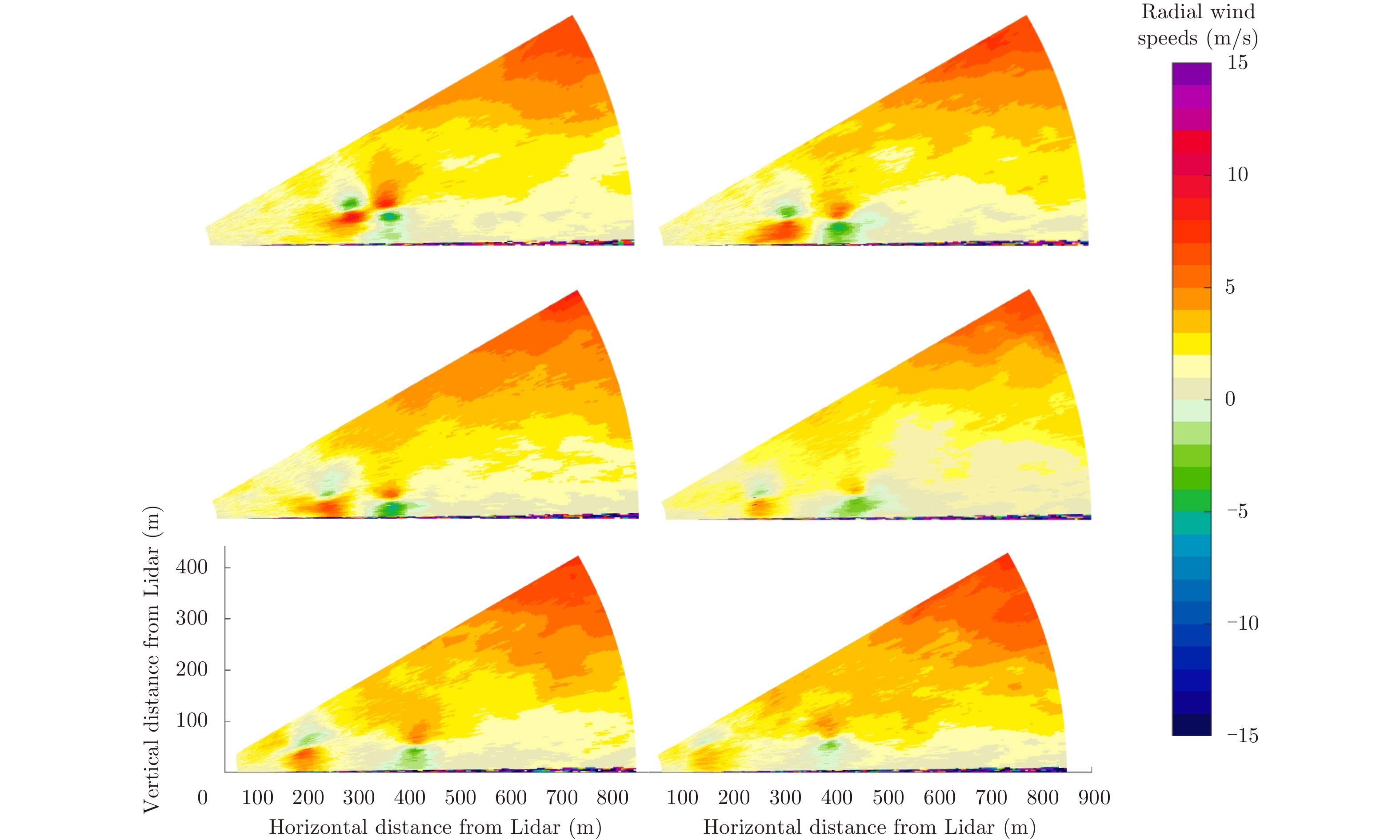
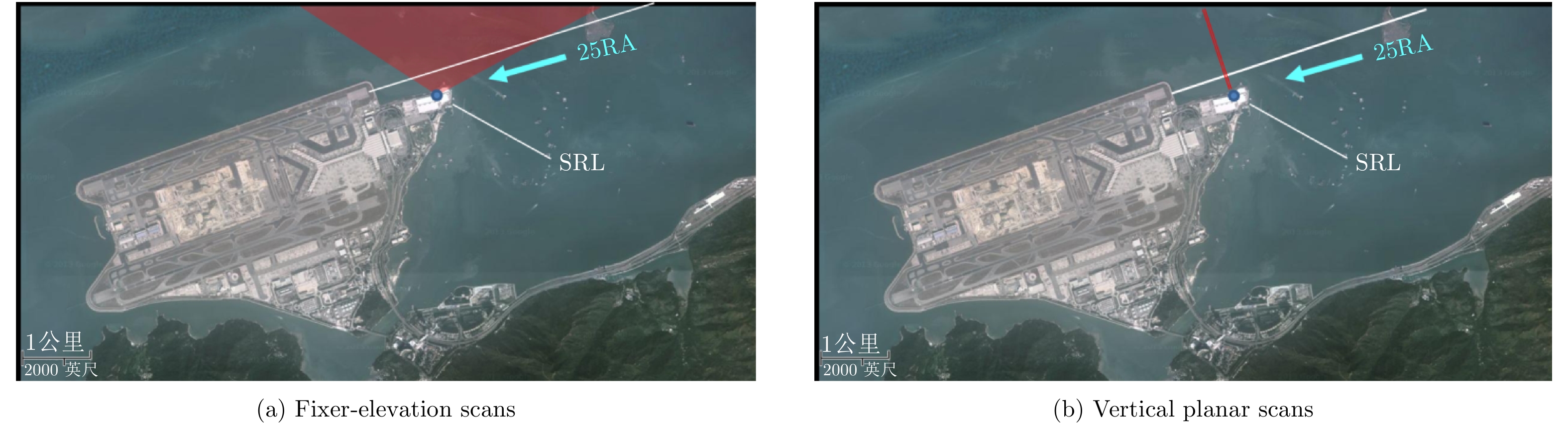
Numerous studies have been performed to better understand the behavior of wake vortices with regards to aircraft characteristics and weather conditionsover the pastten years. These studies have led to the development of the aircraft RECATegorization (RECAT) programs in Europe and in USA. Its phase one focused on redefining distance separation matrix with six static aircraft wake turbulence categories instead of three with the current International Civil Aviation Organization (ICAO) regulations. In Europe, the RECAT-EU regulation is now entering under operational implementation atseveral key airports. As proven by several research projects in the past, LIght Detection And Ranging (LIDAR) sensors are considered as the ground truth wake vortex measurements for assessing the safety impact of a new wake turbulence regulation at an airport in quantifying the risks given the local specificities. LIDAR’s can also be used to perform risk monitoring after the implementation. In this paper, the principle to measure wake vortices with scanning coherent Doppler LIDARs is described as well as its dedicated post-processing. Finally the use of WINDCUBELIDAR based solution for supporting the implementation of new wake turbulenceregulation is described along with satisfyingresults that have permitted the monitoring of the wake vortex encounter risk after the implementation of a new wake turbulence regulation.
Numerous studies have been performed to better understand the behavior of wake vortices with regards to aircraft characteristics and weather conditionsover the pastten years. These studies have led to the development of the aircraft RECATegorization (RECAT) programs in Europe and in USA. Its phase one focused on redefining distance separation matrix with six static aircraft wake turbulence categories instead of three with the current International Civil Aviation Organization (ICAO) regulations. In Europe, the RECAT-EU regulation is now entering under operational implementation atseveral key airports. As proven by several research projects in the past, LIght Detection And Ranging (LIDAR) sensors are considered as the ground truth wake vortex measurements for assessing the safety impact of a new wake turbulence regulation at an airport in quantifying the risks given the local specificities. LIDAR’s can also be used to perform risk monitoring after the implementation. In this paper, the principle to measure wake vortices with scanning coherent Doppler LIDARs is described as well as its dedicated post-processing. Finally the use of WINDCUBELIDAR based solution for supporting the implementation of new wake turbulenceregulation is described along with satisfyingresults that have permitted the monitoring of the wake vortex encounter risk after the implementation of a new wake turbulence regulation.


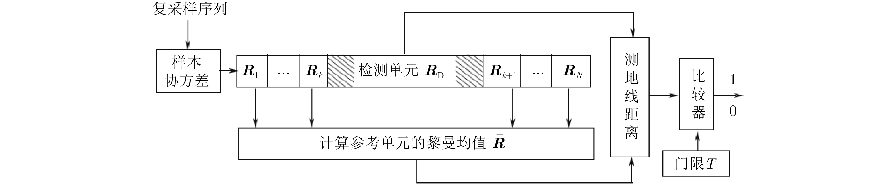
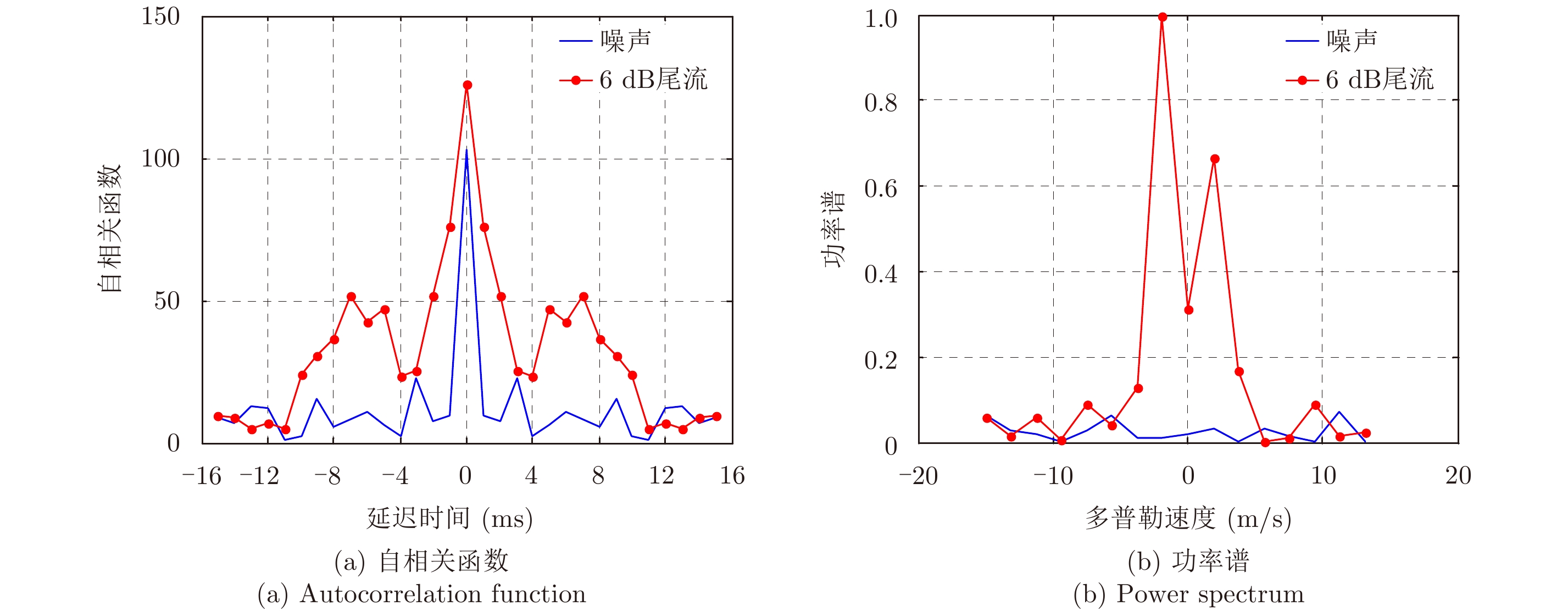
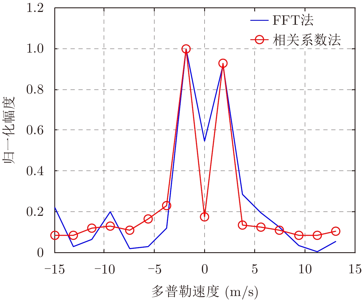
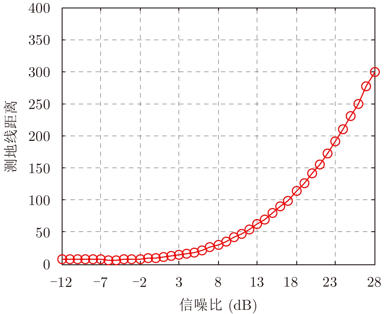
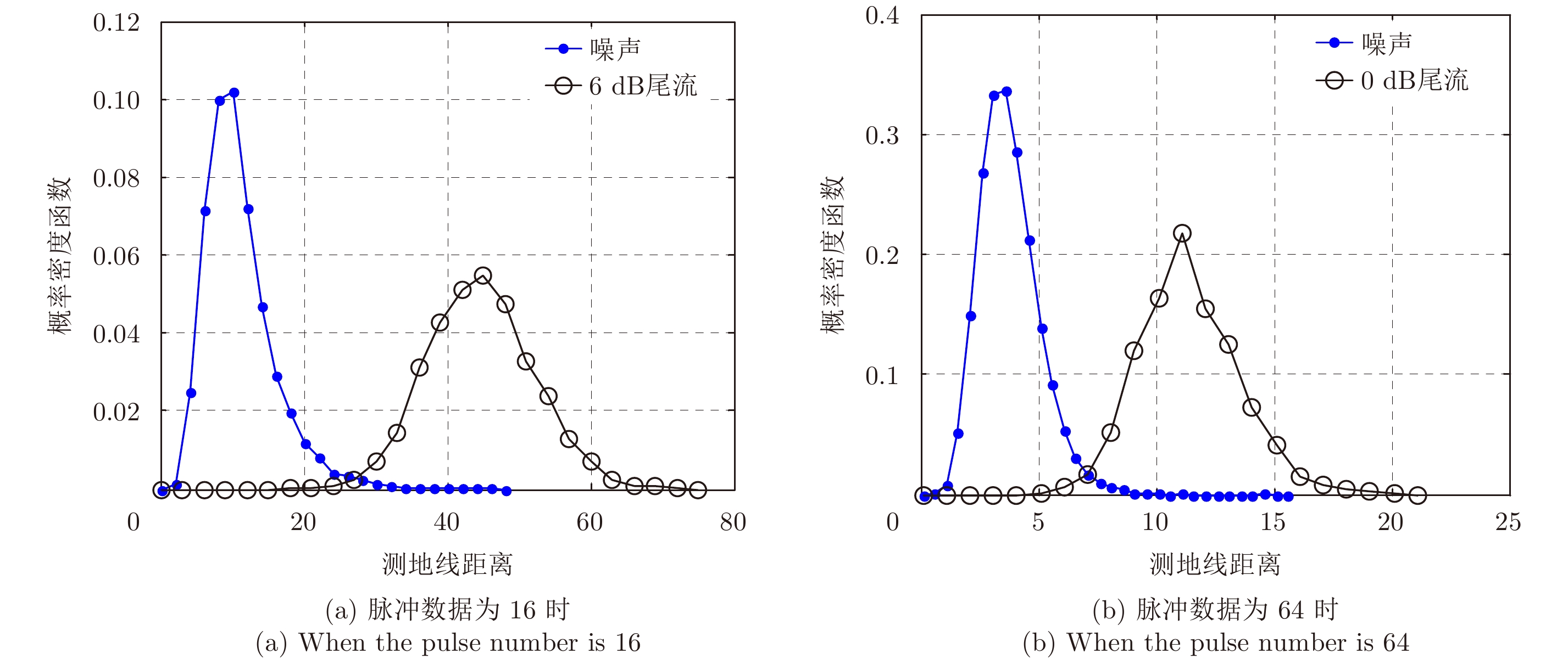
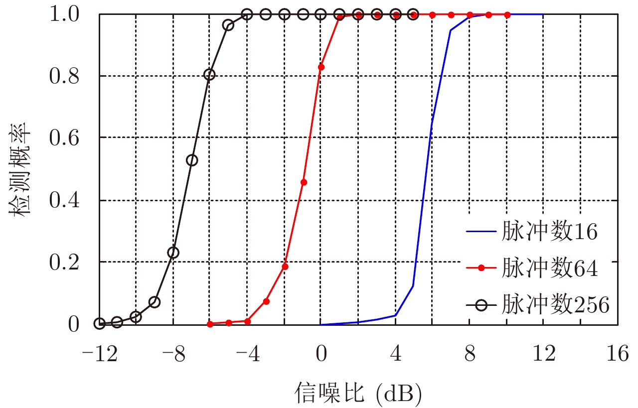
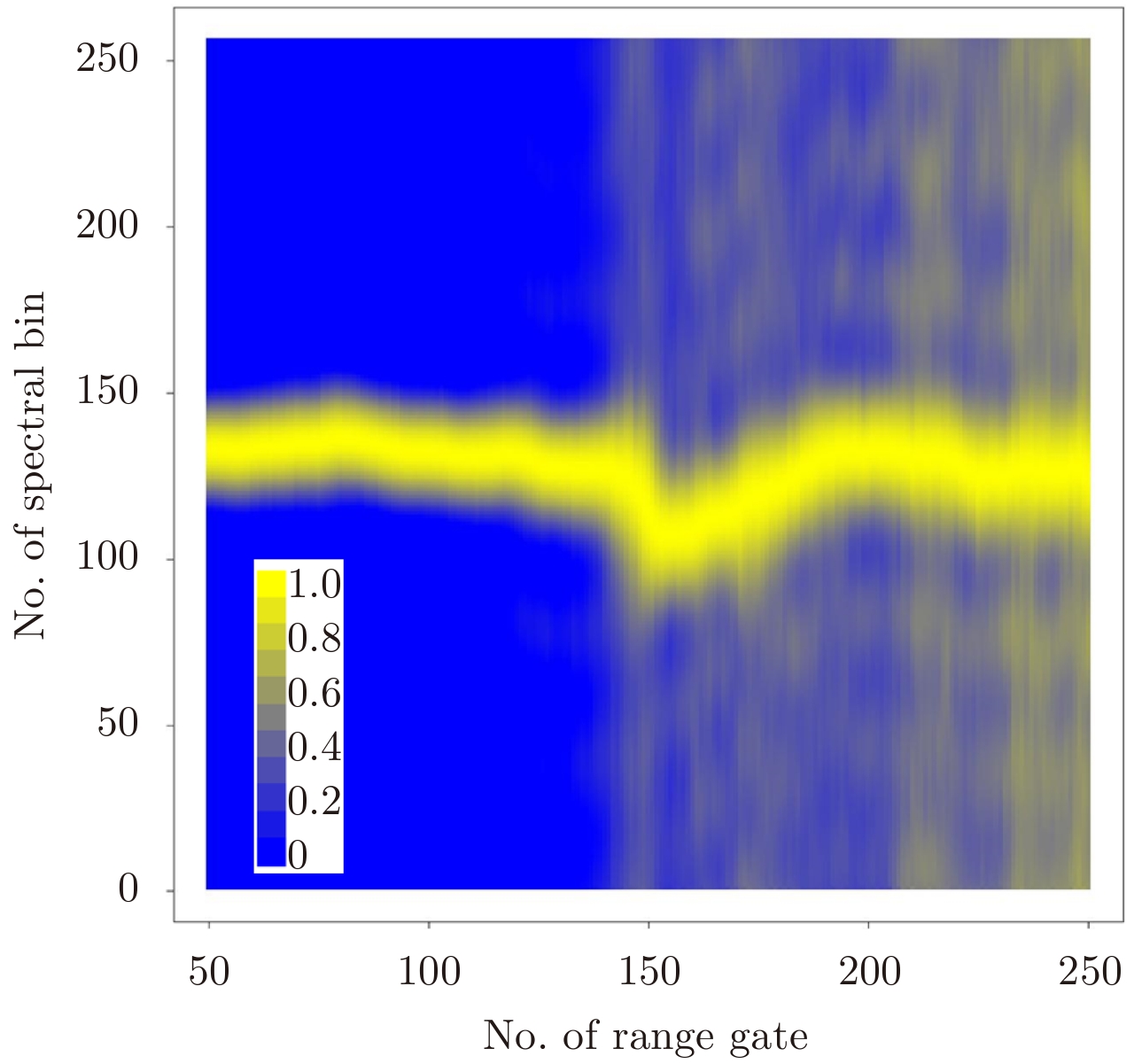
The application of matrix information geometry to radar signal processing and target detection is a new and interesting subject. Wake vortices are Doppler-spread after Fourier transform. The traditional Moving Target Detection (MTD) method cannot adequately accumulate returns power of the whole spectrum. Based on matrix information geometry, a matrix Constant False Alarm Rate (CFAR) detection method is proposed to improve the detection performance of a weak wake target. In this method, covariance matrices of the observed data can be constructed into a matrix manifold; compared with CFAR detection, the geodesic distance between the covariance matrix in the detection cell and the mean of covariance matrices in the secondary cell is regarded as the detection statistics. Using simulated wake vortices, the return data in background noise and the iterative estimation performance of Riemannian mean are analyzed; the geodesic distance of covariance matrices of target return and noise with varying signal-noise rate is analyzed; and the detection performance of the matrix CFAR and the conventional MTD method is compared.
The application of matrix information geometry to radar signal processing and target detection is a new and interesting subject. Wake vortices are Doppler-spread after Fourier transform. The traditional Moving Target Detection (MTD) method cannot adequately accumulate returns power of the whole spectrum. Based on matrix information geometry, a matrix Constant False Alarm Rate (CFAR) detection method is proposed to improve the detection performance of a weak wake target. In this method, covariance matrices of the observed data can be constructed into a matrix manifold; compared with CFAR detection, the geodesic distance between the covariance matrix in the detection cell and the mean of covariance matrices in the secondary cell is regarded as the detection statistics. Using simulated wake vortices, the return data in background noise and the iterative estimation performance of Riemannian mean are analyzed; the geodesic distance of covariance matrices of target return and noise with varying signal-noise rate is analyzed; and the detection performance of the matrix CFAR and the conventional MTD method is compared.


 微信 | 公众平台

