
 作者中心
作者中心 专家审稿
专家审稿 责编办公
责编办公 编辑办公
编辑办公
-
摘要: 随着现代合成孔径雷达(SAR)三维成像系统对成像精度、效率及稳健性要求的不断提高,传统匹配滤波与压缩感知等方法三维成像性能受限。近年来,深度学习技术的迅猛发展为SAR三维成像提供了新的解决路径,通过将神经网络与雷达成像物理模型深度融合,形成了数据驱动与模型驱动协同的学习成像新范式。该文系统综述了深度学习在SAR三维成像中的研究进展,重点围绕超分辨成像与增强成像两大核心问题,基于前馈神经网络和深度展开网络的超分辨三维成像方法、多通道数据预处理和点云后处理三维增强成像方法论述了目前SAR三维成像方向的研究进展和研究热点,并综述了目前行业已公开发布的SAR三维成像数据集。此外,该文还探讨了当前深度学习SAR三维成像在高泛化高精度深度学习SAR超分辨三维成像技术研究、深度学习SAR高度维解模糊技术研究、深度学习SAR三维成像与图像增强一体化研究、深度学习SAR三维成像数据集构建等方面存在的研究挑战,并对未来发展趋势提出展望,旨在为相关领域学者提供研究参考和技术引导。Abstract: With the increasing demands on imaging accuracy, efficiency, and robustness in modern three-Dimensional (3D) Synthetic Aperture Radar (SAR) imaging systems, the performance of traditional 3D imaging methods, such as matched filtering and compressed sensing, has become limited in these aspects. In recent years, the rapid development of Deep Learning (DL) technology has provided new theoretical solutions for SAR 3D imaging by enabling the integration of neural networks with physical radar imaging models, leading to the emergence of a learning-based imaging paradigm that combines data-driven and model-driven approaches. This paper systematically reviews recent research progress in DL-based SAR 3D imaging. Focusing on two core issues, namely super-resolution imaging and enhanced imaging, this paper discusses current research advances and hotspots in SAR 3D imaging. These include super-resolution 3D imaging methods based on feedforward neural networks and deep unfolding networks, as well as 3D enhancement techniques such as multichannel data preprocessing and point cloud post-processing. This paper also summarizes publicly available datasets for SAR 3D imaging. In addition, this paper explores current research challenges in DL SAR 3D imaging, including high-generalization and high-precision DL SAR super-resolution 3D imaging technology, DL SAR elevation dimension disambiguation technology, integrated study of DL SAR 3D imaging and image enhancement, and the construction of DL SAR 3D imaging datasets. This paper provides an outlook on future development trends, aiming to offer research references and technical guidance for scholars in related fields.
-
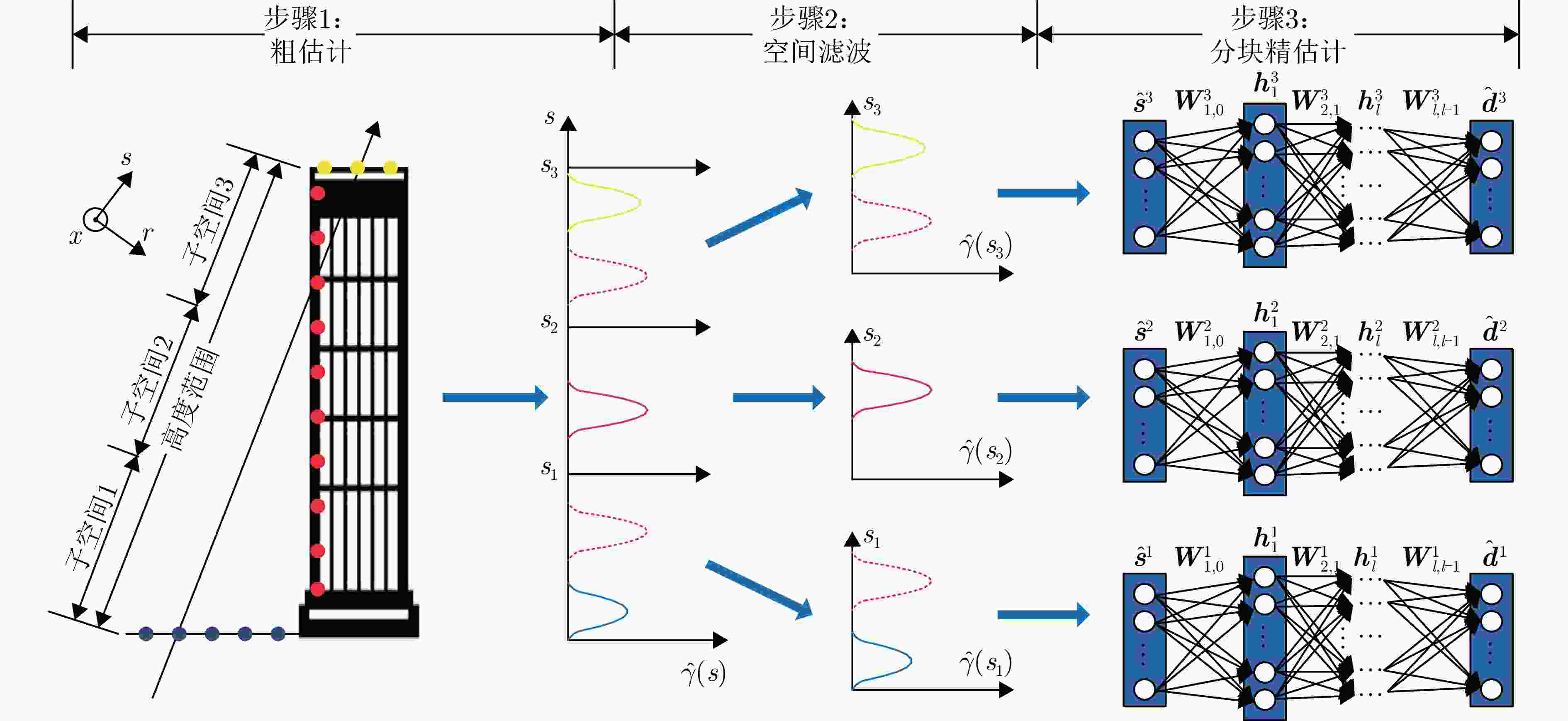
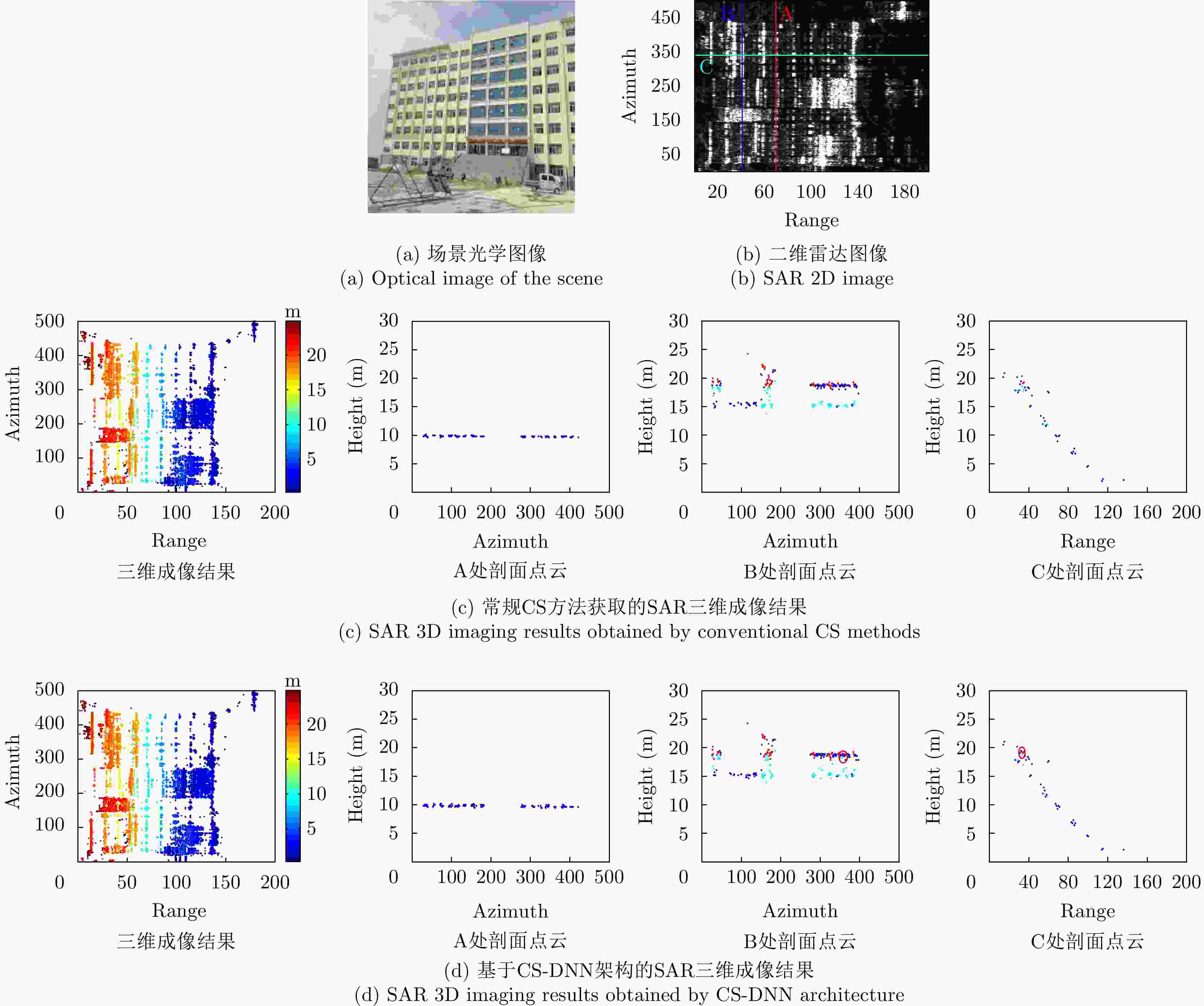
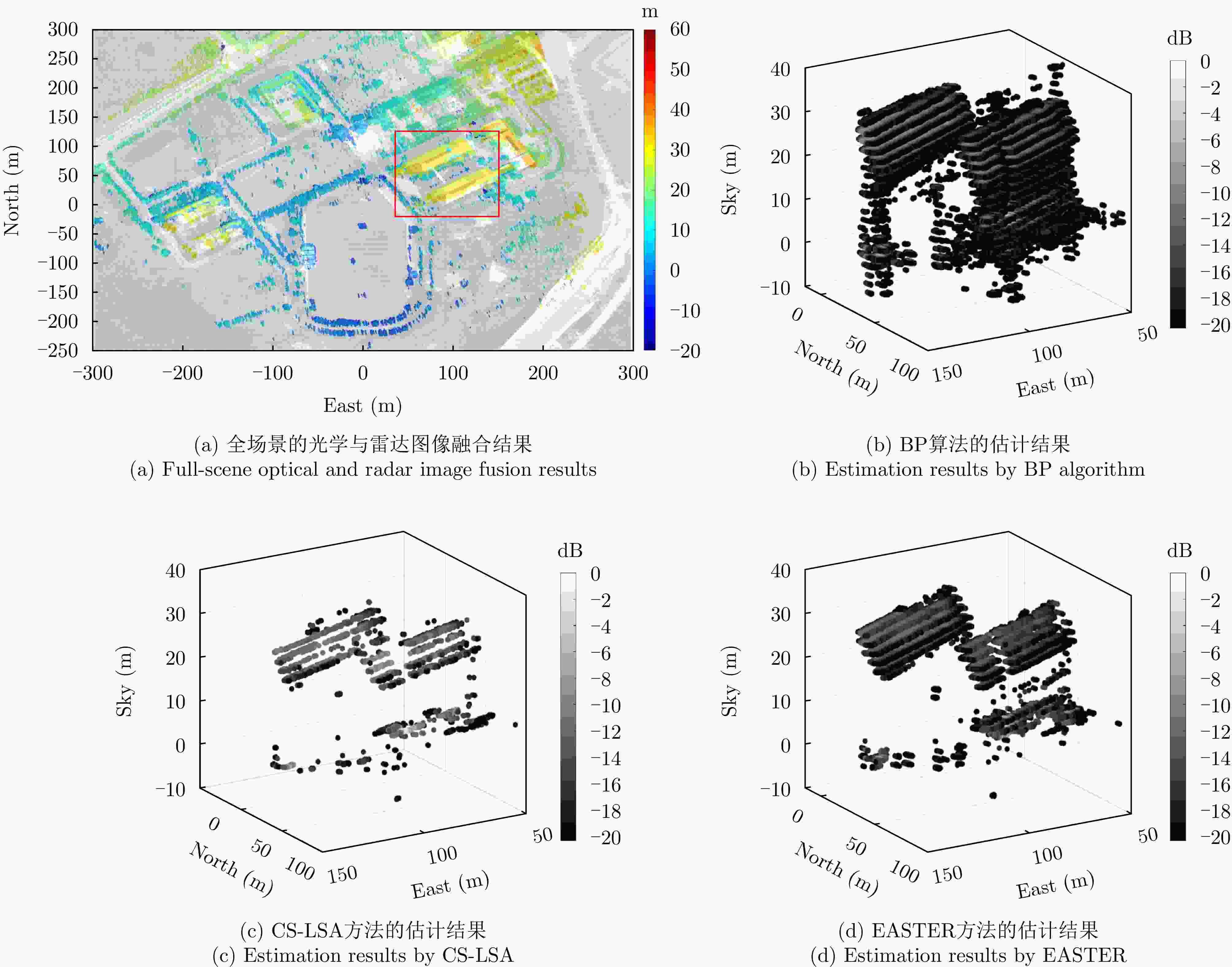
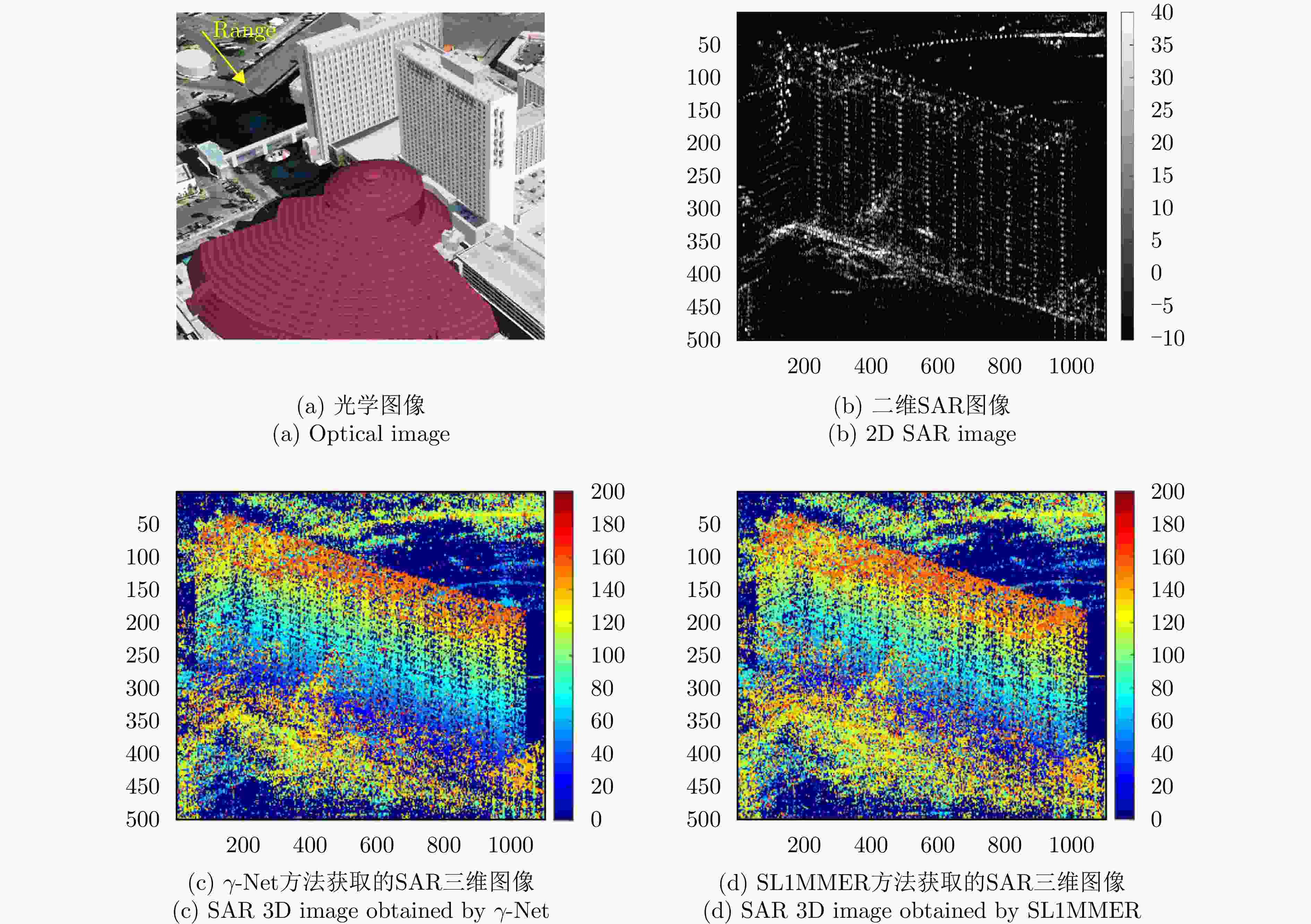
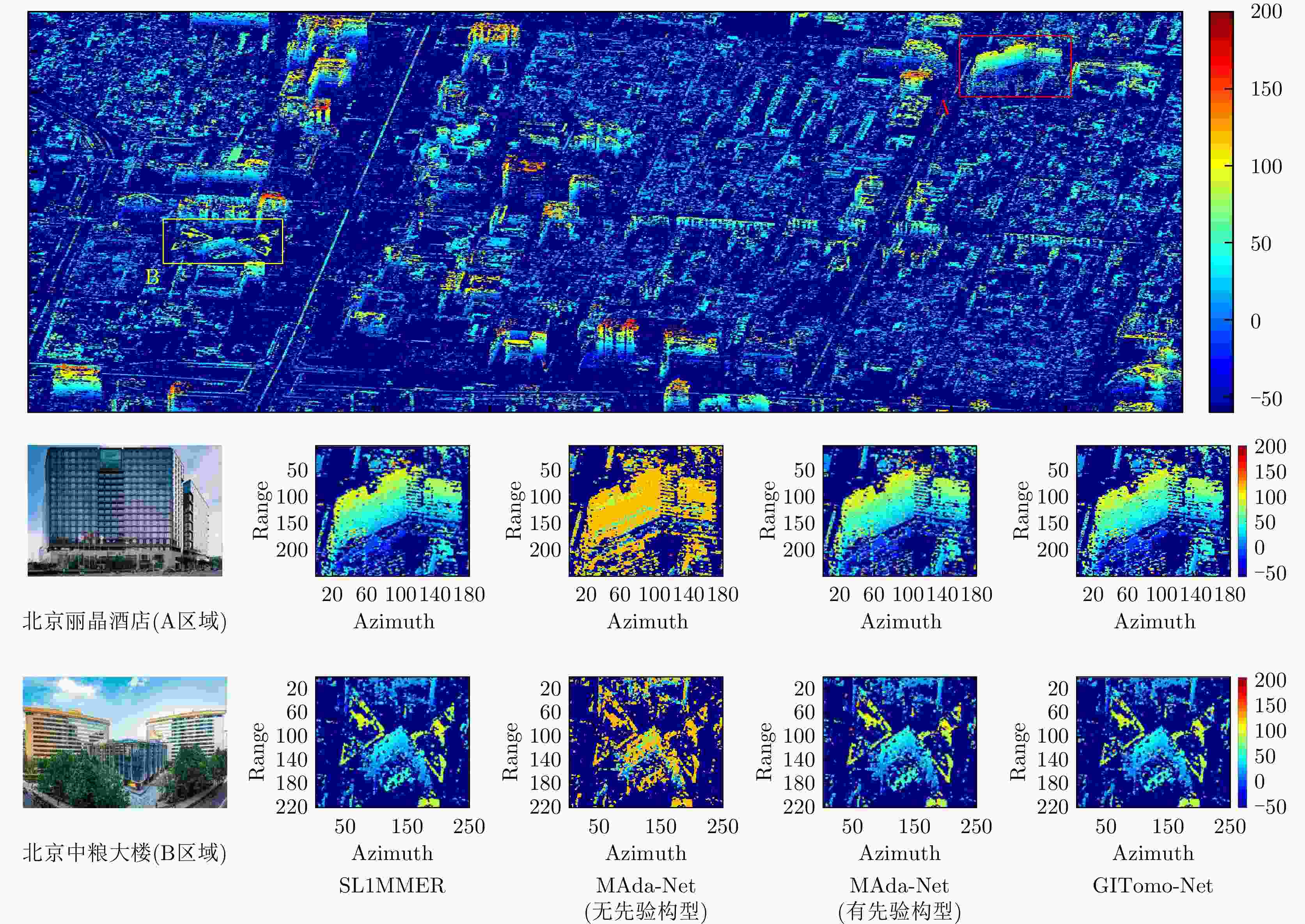
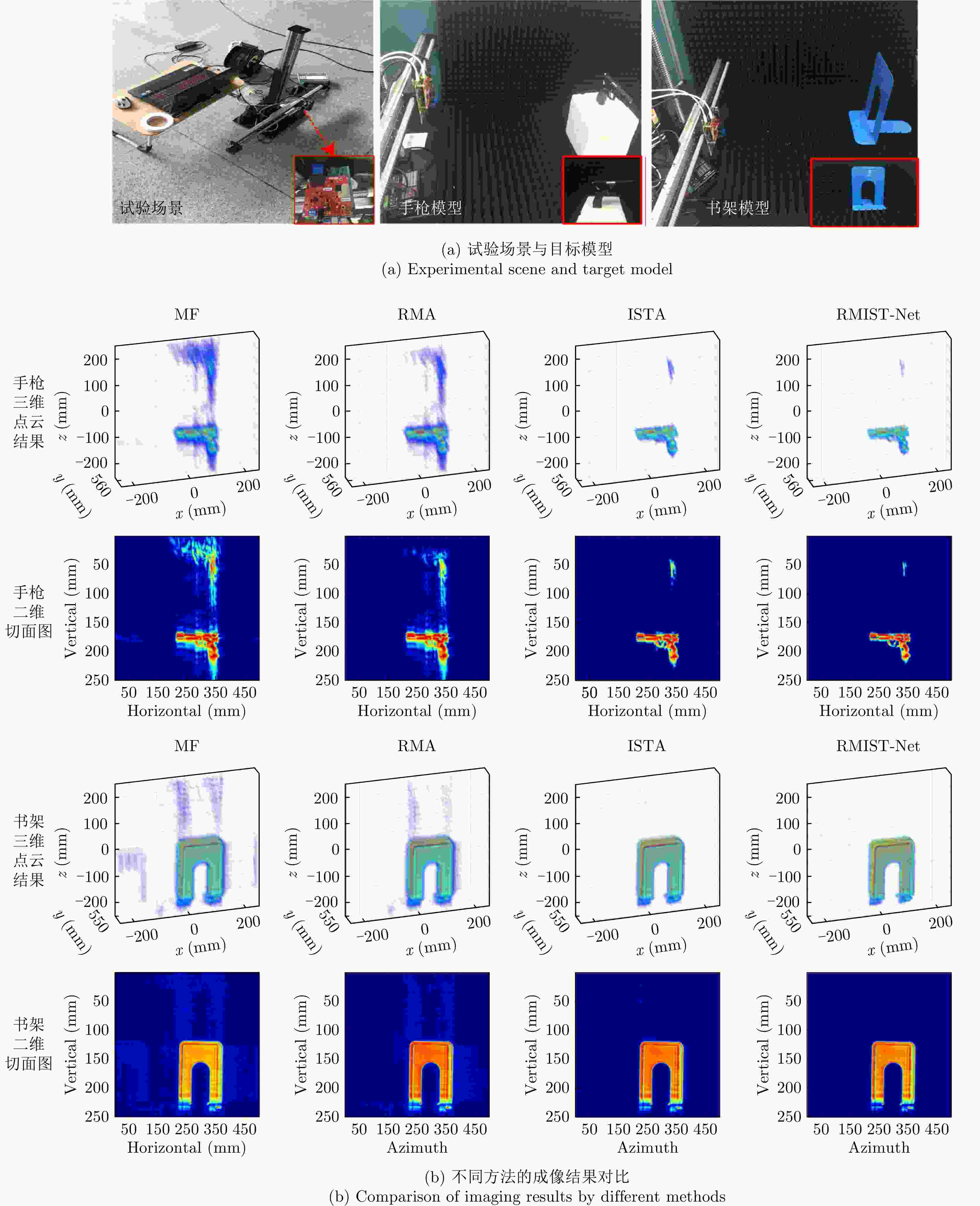
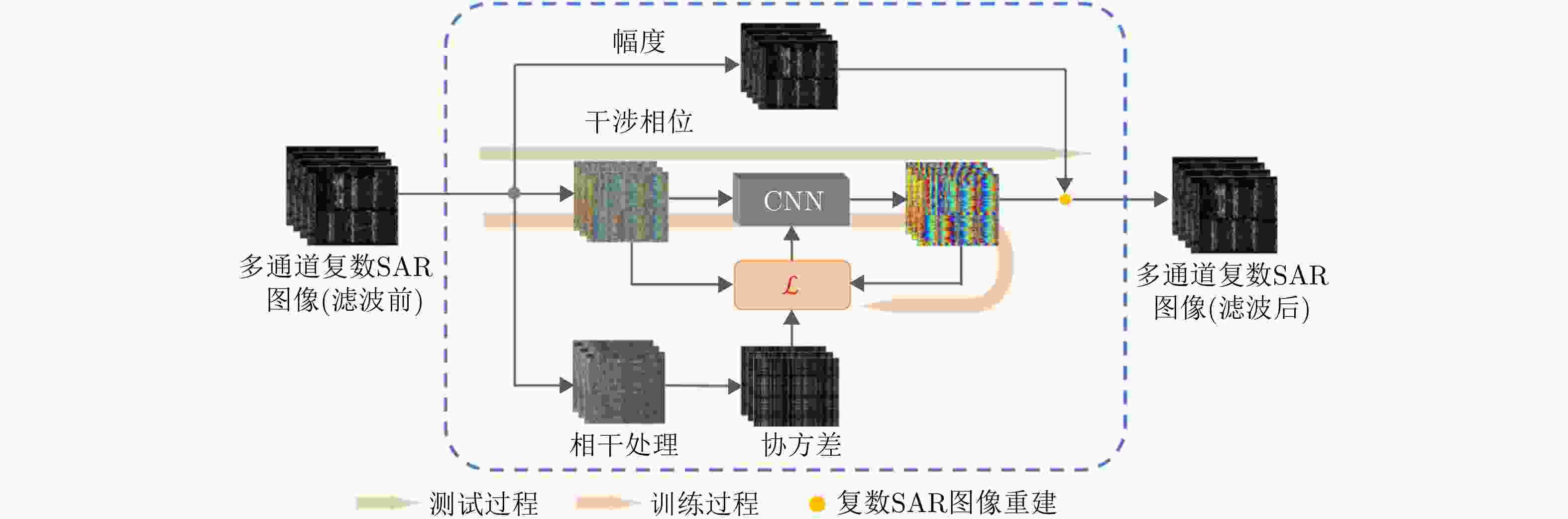
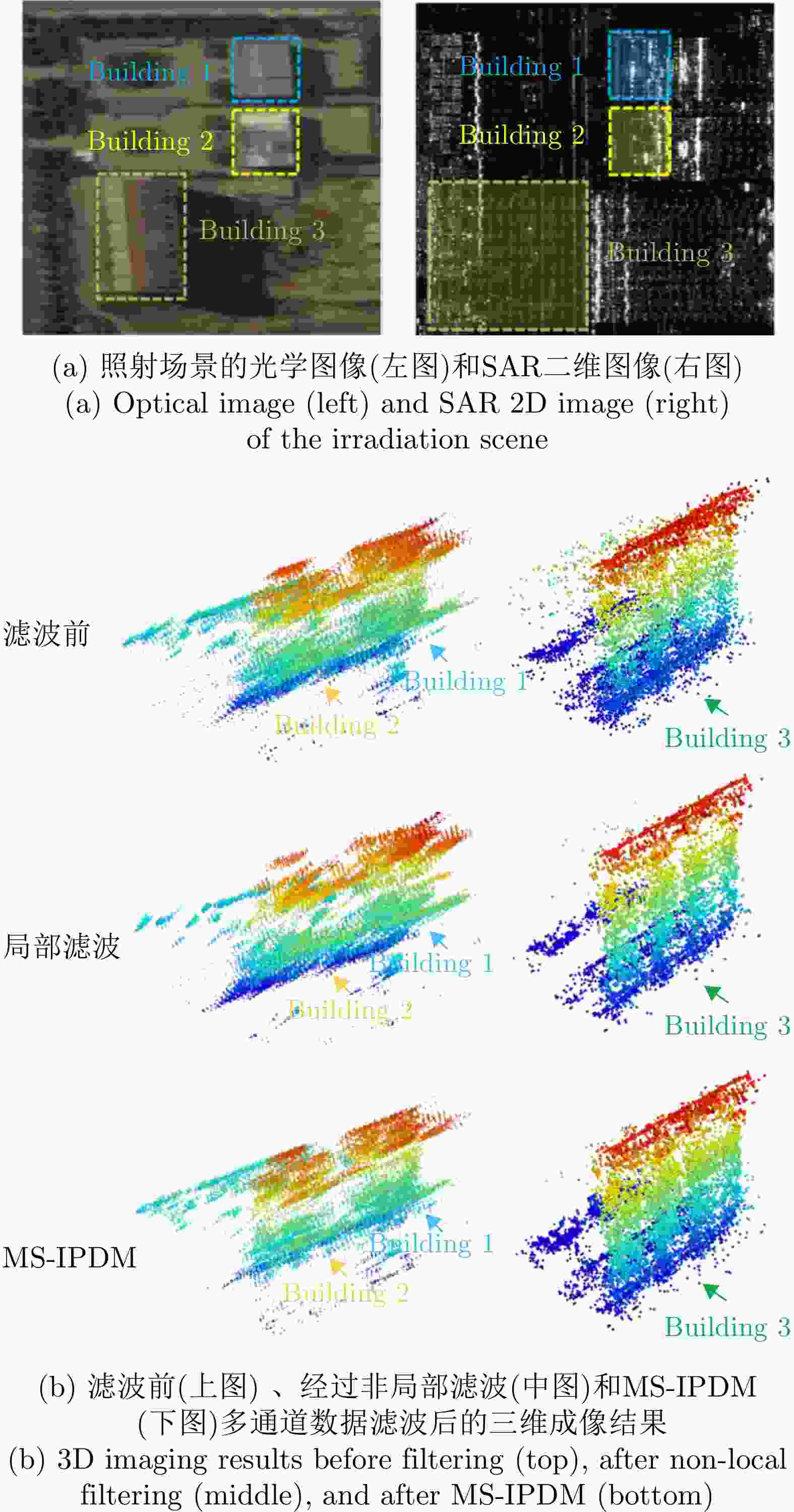

表 1 图6中多航过无人机大合成孔径角SAR三维成像试验的性能指标对比
Table 1. Performance metrics comparison for the multi-pass UAV large synthetic aperture angle SAR 3D imaging experiment by in Fig. 6
方法 SSIM CD (m) 时间(s) BP 0.84 1.12 2.69 CS-LSA 0.83 0.88 6998.75 EASTER 0.92 0.80 11.02  下载: 导出CSV
表 2 图8中北京TerraSAR-X三维成像结果的精度对比
Table 2. Accuracy comparison of the Beijing TerraSAR-X 3D imaging results in Fig. 8
方法 AG/IE 时间(s) 区域 A 区域 B SL1MMER 6.43/2.85 3.39/1.72 13928.25 MAda-Net (无先验构型) × × 236.43 MAda-Net (有先验构型) 7.48/2.76 4.06/1.69 GITomo-Net 7.11/2.85 3.90/1.73 269.88
下载: 导出CSV
表 3 深度学习远场SAR超分辨三维成像方法泛化性对比
Table 3. Comparative analysis of generalization in SAR far-field 3D imaging using deep unfolding networks
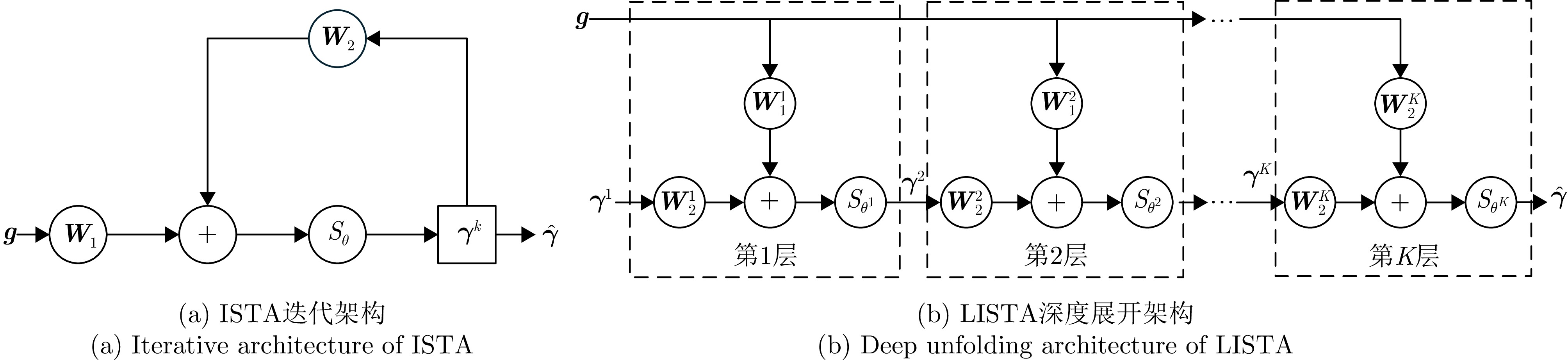
网络结构 成像模型 方法 特点 泛化性 前馈神经网络 单标签分类模型 TSNN[42] 高度维单假设体散射 差 多标签分类模型 CS-DNN架构[27] 利用CS空间滤波后进行多标签分类 中 MLC-Net[44] 网络训练需要观测先验 逐网格点二分类模型 EASTER[43] 针对大合成孔径角,训练无须观测先验 好 深度展开结构 固定构型的稀疏成像模型 AMP-Net[36] 基于AMP深度展开 中 CV-LISTA[35], γ-Net[52], ATASI-Net[54],
AETomo-Net[53], Ada-CLISTAT[55]基于ISTA深度展开 Gated RNN[56] 循环神经网络架构,考虑历史信息 ADMM-Net[37,38] 基于ADMM深度展开 考虑空变构型的稀疏成像模型 MAda-Net[57] 将观测特征与网络参数结合 好 GITomo-Net[58] 网络训练不依赖构型先验
下载: 导出CSV
表 4 图9中近场毫米波SAR三维成像试验成像性能比较
Table 4. Imaging performance comparison of the near-field millimeter-wave SAR 3D imaging experiment conducted in Fig. 9
目标 MF RMA ISTA RMIST-Net ENT 对比度 时间(s) ENT 对比度 时间(s) ENT 对比度 时间(s) ENT 对比度 时间(s) 手枪模型 0.27 8.27 0.06 0.67 9.08 0.11 0.10 12.06 2.33 0.07 14.19 0.07 书架模型 0.66 3.70 0.06 1.19 3.72 0.11 0.50 3.85 2.34 0.35 4.03 0.06 注:加粗数值表示最佳指标值。
下载: 导出CSV
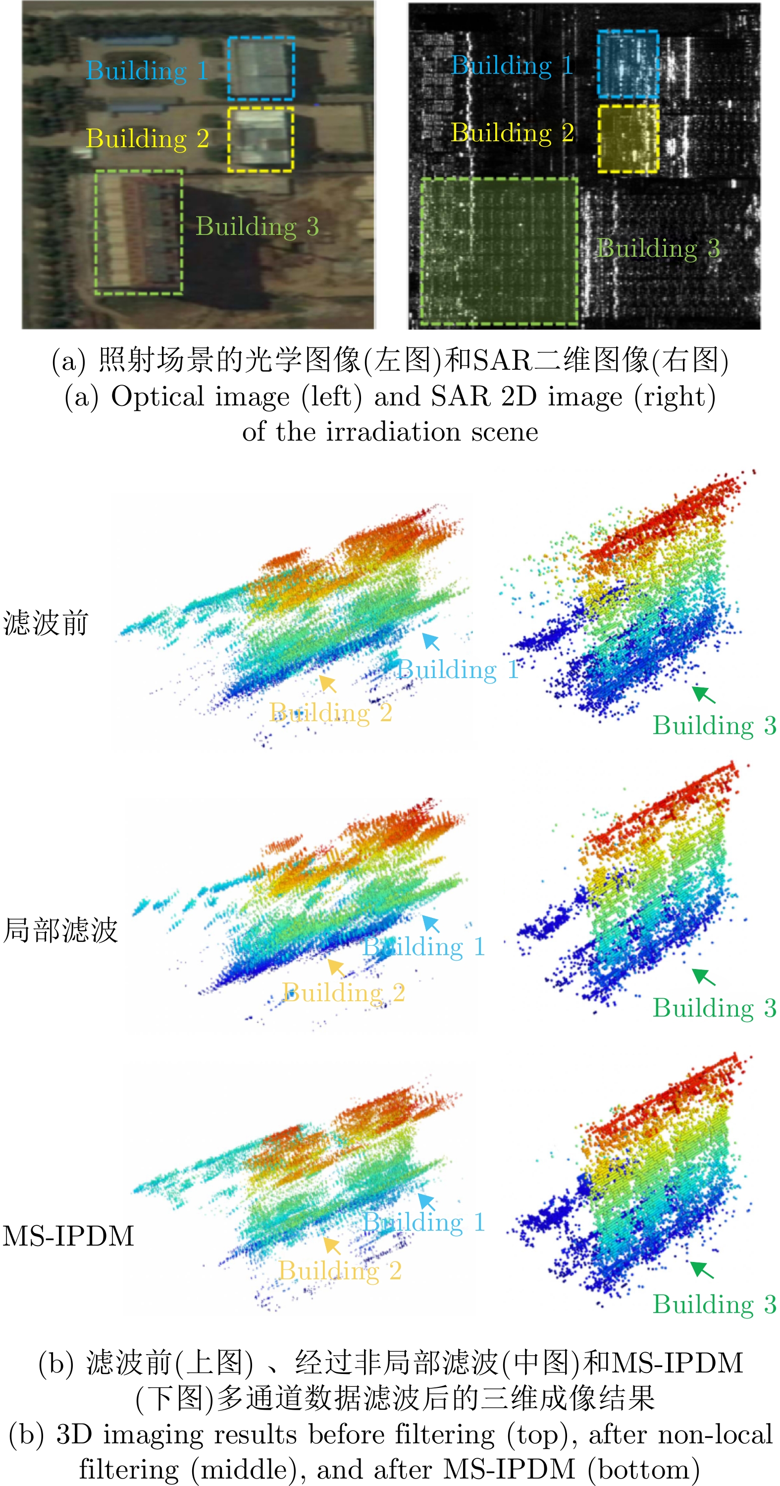
表 5 对图11中的不同滤波方法获取的三维SAR成像结果的性能指标对比
Table 5. The comparison of the 3D SAR imaging results obtained using different filtering methods in Fig. 11
方法 MAEb1 MAEb2 MAEb3 STDb1 STDb2 STDb3 未滤波 1.4485 1.5230 2.9150 1.9082 2.0038 1.5016 非局部滤波 1.1293 1.3801 1.3675 1.4727 1.7815 1.9897 MS-IPDM 1.1133 1.4453 1.2105 1.1689 1.5850 1.3184 注:加粗数值表示最佳指标值。
下载: 导出CSV
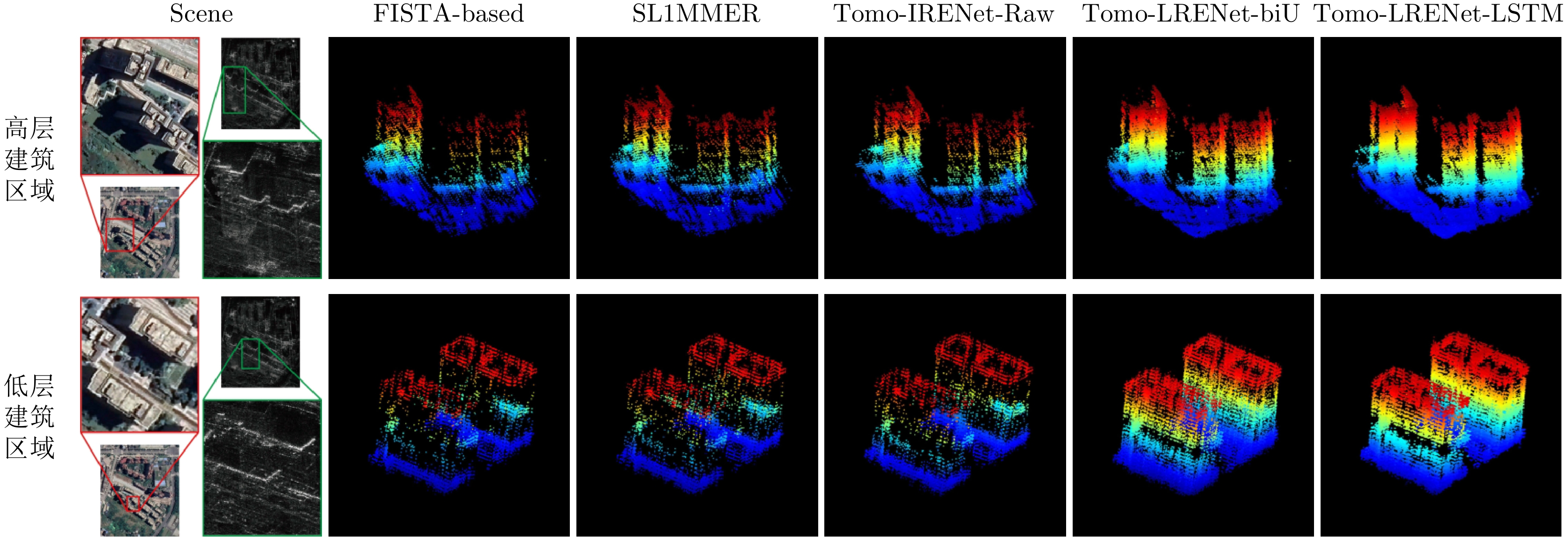
表 6 文献[32]中对多种不同方法的SAR三维成像性能的对比
Table 6. Ref. [32] presents a comparison of the SAR 3D imaging performance of multiple different method
方法 性能 分辨能力 离群值抑制 重建精度 重建效率 FISTA ↑ ↑ ↑ ↑ SL1MMER ↑↑ ↑ ↑ ↑ Tomo-IRENet-Raw ↑ ↑ ↑ ↑↑↑↑ Tomo-LRENet-biU ↑↑↑ ↑↑ ↑↑↑ ↑↑↑ Tomo-LRENet-LSTM ↑↑↑ ↑↑↑ ↑↑↑↑ ↑↑↑↑ 注:符号 ↑ 表示同一方面各方法间的相对比较,箭头数量仅表示相对优劣程度,比较仅在同一列内进行。
下载: 导出CSV
表 7 SAR三维成像数据集获取途径
Table 7. SAR 3D imaging dataset acquisition methods
数据集 单位 获取途径 GOTCHA 美国空军实验室 https://www.sdms.afrl.af.mil/index.php?collection=gotcha (SDMS)FMCW SAR 美国密歇根大学 https://github.com/AdityaMuppala/FMCW-SAR-3D-FFT (Github)SARMV3D-Imaging-1.0 空天院 https://radars.ac.cn/web/data/getData?newsColumnId=aac4fc85-5950-432a-8ca2-bf14608d4461 (雷达学报)SARMV3D-Imaging-2.0 空天院 https://radars.ac.cn/web/data/getData?newsColumnId=f9286c6f-a287-4e5f-be76-105b07677c3c (雷达学报)SARMV3D-Imaging-3.0 空天院 https://radars.ac.cn/web/data/getData?newsColumnId=1cbc9f2d-f2ee-4748-9972-748c007f697f (雷达学报)高分辨三维毫米波雷达
数据集1.0电子科技大学 https://radars.ac.cn/web/data/getData?dataType=3DRIED (雷达学报)涪城一号SAR三维成像
数据集1.0南京航空航天大学 https://radars.ac.cn/web/data/getData?dataType=SpaceborneSAR3Dimaging (雷达学报)DistUAV-Tomo3D-1.0 北京理工大学 https://signal.ejournal.org.cn/datasetcn?columnId=7cd9c1df-d080-4fa6-8a2d-4cd8b4010a1a
(信号处理)3DSARBuSim1.0 中山大学 https://www.scidb.cn/en/detail?dataSetId=89df9949f42d4e69958ccadf7b67f05c
(电子与信息学报)
下载: 导出CSV
-
[1] FORNARO G, SERAFINO F, and SOLDOVIERI F. Three-dimensional focusing with multipass SAR data[J]. IEEE Transactions on Geoscience and Remote Sensing, 2003, 41(3): 507–517. doi: 10.1109/TGRS.2003.809934. [2] NANNINI M, SCHEIBER R, HORN R, et al. First 3-D reconstructions of targets hidden beneath foliage by means of polarimetric SAR tomography[J]. IEEE Geoscience and Remote Sensing Letters, 2012, 9(1): 60–64. doi: 10.1109/LGRS.2011.2160329. [3] ANTONELLO G, CASAGLI N, FARINA P, et al. Ground-based SAR interferometry for monitoring mass movements[J]. Landslides, 2004, 1(1): 21–28. doi: 10.1007/s10346-003-0009-6. [4] LIU Peiyao, ZHU Kaiwen, WANG Zhen, et al. Ground-based radar three-dimensional imaging for moon under sparse observations[C]. IET International Radar Conference (IRC 2023), Chongqing, China, 2023: 4183–4188. doi: 10.1049/icp.2024.1786. [5] 李烈辰, 李道京. 基于压缩感知的连续场景稀疏阵列SAR三维成像[J]. 电子与信息学报, 2014, 36(9): 2166–2172. doi: 10.3724/SP.J.1146.2013.01645.LI Liechen and LI Daojing. Sparse array SAR 3D imaging for continuous scene based on compressed sensing[J]. Journal of Electronics & Information Technology, 2014, 36(9): 2166–2172. doi: 10.3724/SP.J.1146.2013.01645. [6] REIGBER A and MOREIRA A. First demonstration of airborne SAR tomography using multibaseline L-band data[J]. IEEE Transactions on Geoscience and Remote Sensing, 2000, 38(5): 2142–2152. doi: 10.1109/36.868873. [7] WANG Yan, DING Zegang, LI Linghao, et al. First demonstration of single-pass distributed SAR tomographic imaging with a P-band UAV SAR prototype[J]. IEEE Transactions on Geoscience and Remote Sensing, 2022, 60: 5238618. doi: 10.1109/TGRS.2022.3221859. [8] BUDILLON A, EVANGELISTA A, and SCHIRINZI G. SAR tomography from sparse samples[C]. 2009 IEEE International Geoscience and Remote Sensing Symposium, Cape Town, South Africa, 2009: IV-865–IV-868. doi: 10.1109/IGARSS.2009.5417514. [9] ZHU Xiaoxiang and BAMLER R. Very high resolution SAR tomography via compressive sensing[C]. 6th International Workshop on Advanced Optical Metrology on Fringe 2009, Frascati, Italy, 2009. [10] 赵克祥, 毕辉, 张冰尘. 基于快速阈值迭代的SAR层析成像处理方法[J]. 系统工程与电子技术, 2017, 39(5): 1019–1023. doi: 10.3969/j.issn.1001-506X.2017.05.11.ZHAO Kexiang, BI Hui, and ZHANG Bingchen. SAR tomography method based on fast iterative shrinkage-thresholding[J]. Systems Engineering and Electronics, 2017, 39(5): 1019–1023. doi: 10.3969/j.issn.1001-506X.2017.05.11. [11] WANG Xiao, XU Feng, and JIN Yaqiu. The iterative reweighted alternating direction method of multipliers for separating structural layovers in SAR tomography[J]. IEEE Geoscience and Remote Sensing Letters, 2017, 14(11): 1883–1887. doi: 10.1109/LGRS.2017.2694825. [12] WANG Xiao and XU Feng. Tomographic SAR inversion by atomic-norm minimization-the gridless compressive sensing approach[J]. IEEE Transactions on Geoscience and Remote Sensing, 2022, 60: 5239113. doi: 10.1109/TGRS.2022.3223524. [13] LIU Minkun, WAND Yan, DING Zegang, et al. Atomic norm minimization based fast off-grid tomographic SAR imaging with nonuniform sampling[J]. IEEE Transactions on Geoscience and Remote Sensing, 2024, 62: 5203517. doi: 10.1109/TGRS.2024.3358863. [14] ZHANG Siqian, ZHU Yutao, DONG Ganggang, et al. Truncated SVD-based compressive sensing for downward-looking three-dimensional SAR imaging with uniform/nonuniform linear array[J]. IEEE Geoscience and Remote Sensing Letters, 2015, 12(9): 1853–1857. doi: 10.1109/LGRS.2015.2431254. [15] ZHU Xiaoxiang and BAMLER R. Demonstration of super-resolution for tomographic SAR imaging in urban environment[J]. IEEE Transactions on Geoscience and Remote Sensing, 2012, 50(8): 3150–3157. doi: 10.1109/TGRS.2011.2177843. [16] ZHU Xiaoxiang and BAMLER R. Super-resolution power and robustness of compressive sensing for spectral estimation with application to spaceborne tomographic SAR[J]. IEEE Transactions on Geoscience and Remote Sensing, 2012, 50(1): 247–258. doi: 10.1109/TGRS.2011.2160183. [17] HUANG Yue, FERRO-FAMIL L, and REIGBER A. Under-foliage object imaging using SAR tomography and polarimetric spectral estimators[J]. IEEE Transactions on Geoscience and Remote Sensing, 2012, 50(6): 2213–2225. doi: 10.1109/TGRS.2011.2171494. [18] SHI Yilei, ZHU Xiaoxiang, and BAMLER R. Nonlocal compressive sensing-based SAR tomography[J]. IEEE Transactions on Geoscience and Remote Sensing, 2019, 57(5): 3015–3024. doi: 10.1109/TGRS.2018.2879382. [19] RAMBOUR C, DENIS L, TUPIN F, et al. Introducing spatial regularization in SAR tomography reconstruction[J]. IEEE Transactions on Geoscience and Remote Sensing, 2019, 57(11): 8600–8617. doi: 10.1109/TGRS.2019.2921756. [20] LIN Bo, LI Chao, JI Yicai, et al. A millimeter-wave 3D imaging algorithm for MIMO synthetic aperture radar[J]. Sensors, 2023, 23(13): 5979. doi: 10.3390/s23135979. [21] WANG Mou, WEI Shunjun, SHI Jun, et al. 3-D SAR imaging via perceptual learning framework with adaptive sparse prior[J]. IEEE Transactions on Geoscience and Remote Sensing, 2023, 61: 5202716. doi: 10.1109/TGRS.2023.3237660. [22] HAN Dong, ZHOU Liangjiang, JIAO Zekun, et al. Efficient 3D image reconstruction of airborne TomoSAR based on back projection and improved adaptive ISTA[J]. IEEE Access, 2021, 9: 47399–47410. doi: 10.1109/ACCESS.2021.3066984. [23] KHALIL ALSMADI M, OMAR K B, NOAH S A, et al. Performance comparison of multi-layer perceptron (back propagation, delta rule and perceptron) algorithms in neural networks[C]. 2009 IEEE International Advance Computing Conference, Patiala, India, 2009: 296–299. doi: 10.1109/IADCC.2009.4809024. [24] 周飞燕, 金林鹏, 董军. 卷积神经网络研究综述[J]. 计算机学报, 2017, 40(6): 1229–1251. doi: 10.11897/SP.J.1016.2017.01229.ZHOU Feiyan, JIN Linpeng, and DONG Jun. Review of convolutional neural network[J]. Chinese Journal of Computers, 2017, 40(6): 1229–1251. doi: 10.11897/SP.J.1016.2017.01229. [25] 刘建伟, 宋志妍. 循环神经网络研究综述[J]. 控制与决策, 2022, 37(11): 2753–2768. doi: 10.13195/j.kzyjc.2021.1241.LIU Jianwei and SONG Zhiyan. Overview of recurrent neural networks[J]. Control and Decision, 2022, 37(11): 2753–2768. doi: 10.13195/j.kzyjc.2021.1241. [26] 王坤峰, 苟超, 段艳杰, 等. 生成式对抗网络GAN的研究进展与展望[J]. 自动化学报, 2017, 43(3): 321–332. doi: 10.16383/j.aas.2017.y000003.WANG Kunfeng, GOU Chao, DUAN Yanjie, et al. Generative adversarial networks: The state of the art and beyond[J]. Acta Automatica Sinica, 2017, 43(3): 321–332. doi: 10.16383/j.aas.2017.y000003. [27] WU Chunxiao, ZHANG Zenghui, CHEN Longyong, et al. Super-resolution for MIMO array SAR 3-D imaging based on compressive sensing and deep neural network[J]. IEEE Journal of Selected Topics in Applied Earth Observations and Remote Sensing, 2020, 13: 3109–3124. doi: 10.1109/JSTARS.2020.3000760. [28] SHEN Rong, WEI Shunjun, ZHOU Zichen, et al. Image enhancement of 3-D SAR via U-net framework[C]. IGARSS 2022–2022 IEEE International Geoscience and Remote Sensing Symposium, Kuala Lumpur, Malaysia, 2022: 947–950. doi: 10.1109/IGARSS46834.2022.9884760. [29] SERAFÍN-GARCÍA S A, NANNINI M, HÄNSCH R, et al. Deep-learning-based view interpolation toward improved TomoSAR focusing[J]. IEEE Geoscience and Remote Sensing Letters, 2024, 21: 4014205. doi: 10.1109/LGRS.2024.3424195. [30] KUMAR S V, SUN Xinyao, WANG Zheng, et al. A U-net approach for InSAR phase unwrapping and denoising[J]. Remote Sensing, 2023, 15(21): 5081. doi: 10.3390/rs15215081. [31] ZENG Tianjiao, ZHAN Xu, REN Yu, et al. Exploring spatial feature regularization in deep-learning-based TomoSAR reconstruction: A preliminary study and performance analysis[J]. IEEE Transactions on Geoscience and Remote Sensing, 2025, 63: 5201227. doi: 10.1109/TGRS.2024.3521278. [32] LIU Liang, REN Yu, ZHANG Xiaoling, et al. Towards realistic TomoSAR reconstruction through light reconstruction and enhancement[C]. 2024 IEEE International Conference on Signal, Information and Data Processing (ICSIDP), Zhuhai, China, 2024: 1–5. doi: 10.1109/ICSIDP62679.2024.10869124. [33] WANG Shihong, GUO Jiayi, ZHANG Yueting, et al. TomoSAR 3D reconstruction for buildings using very few tracks of observation: A conditional generative adversarial network approach[J]. Remote Sensing, 2021, 13(24): 5055. doi: 10.3390/rs13245055. [34] WANG Mou, HU Yifei, WEI Shunjun, et al. Unsupervised 3D SAR imaging network based on generative adversary learning[J]. IEEE Transactions on Antennas and Propagation, 2025, 73(7): 4621–4636. doi: 10.1109/TAP.2025.3547742. [35] QIAN Kun, WANG Yuanyuan, SHI Yilei, et al. Super-resolving SAR tomography using deep learning[C]. 2021 IEEE International Geoscience and Remote Sensing Symposium IGARSS, Brussels, Belgium, 2021: 4810–4813. doi: 10.1109/IGARSS47720.2021.9554165. [36] GAO Jingkun, YE Yu, LI Shizhong, et al. Fast super-resolution 3D SAR imaging using an unfolded deep network[C]. 2019 IEEE International Conference on Signal, Information and Data Processing (ICSIDP), Chongqing, China, 2019: 1–5. doi: 10.1109/ICSIDP47821.2019.9173392. [37] SHEN Rong, WEI Shunjun, WEN Yanbo, et al. A 3-D imaging method of building with TomoSAR based on DUADMM-net[C]. IGARSS 2023–2023 IEEE International Geoscience and Remote Sensing Symposium, Pasadena, USA, 2023: 7933–7936. doi: 10.1109/IGARSS52108.2023.10282080. [38] LIU Changhao, WANG Yan, DING Zegang, et al. Analysis of deep learning 3-D imaging methods based on UAV SAR[C]. IGARSS 2022–2022 IEEE International Geoscience and Remote Sensing Symposium, Kuala Lumpur, Malaysia, 2022: 2951–2954. doi: 10.1109/IGARSS46834.2022.9883292. [39] BEBIS G and GEORGIOPOULOS M. Feed-forward neural networks[J]. IEEE Potentials, 1994, 13(4): 27–31. doi: 10.1109/45.329294. [40] POPESCU M C, BALAS V E, PERESCU-POPESCU L, et al. Multilayer perceptron and neural networks[J]. WSEAS Transactions on Circuits and Systems, 2009, 8(7): 579–588. doi: 10.5555/1639537.1639542. [41] WU Jianxin. Introduction to convolutional neural networks[J]. National Key Lab for Novel Software Technology, Nanjing University, China, 2017, 5(23): 495. [42] BUDILLON A, JOHNSY A C, SCHIRINZI G, et al. SAR tomography based on deep learning[C]. IGARSS 2019–2019 IEEE International Geoscience and Remote Sensing Symposium, Yokohama, Japan, 2019: 3625–3628. doi: 10.1109/IGARSS.2019.8900616. [43] LIU Changhao, WANG Yan, ZHANG Guangbin, et al. High resolution large elevation synthetic aperture tomographic SAR imaging with classifier-based imaging architecture[J]. IEEE Journal of Selected Topics in Applied Earth Observations and Remote Sensing, 2025, 18: 20666–20677. doi: 10.1109/JSTARS.2025.3593845. [44] OUYANG Depeng, ZHANG Yueting, GUO Jiayi, et al. MLC-net: A sparse reconstruction network for TomoSAR imaging based on multi-label classification neural network[J]. ISPRS Journal of Photogrammetry and Remote Sensing, 2025, 220: 85–99. doi: 10.1016/j.isprsjprs.2024.11.018. [45] ZENG Tao, LIU Minkun, WANG Yan, et al. Tomographic SAR imaging with large elevation aperture: A P-band small UAV demonstration[J]. Science China Information Sciences, 2022, 65(3): 132303. doi: 10.1007/s11432-021-3391-2. [46] RANGAN S, SCHNITER P, and FLETCHER A K. Vector approximate message passing[J]. IEEE Transactions on Information Theory, 2019, 65(10): 6664–6684. doi: 10.1109/TIT.2019.2916359. [47] BREDIES K and LORENZ D A. Linear convergence of iterative soft-thresholding[J]. Journal of Fourier Analysis and Applications, 2008, 14(5): 813–837. doi: 10.1007/s00041-008-9041-1. [48] BOYD S, PARIKH N, CHU E, et al. Distributed optimization and statistical learning via the alternating direction method of multipliers[J]. Foundations and Trends® in Machine Learning, 2011, 3(1): 1–122. doi: 10.1561/2200000016. [49] TROPP J A and GILBERT A C. Signal recovery from random measurements via orthogonal matching pursuit[J]. IEEE Transactions on Information Theory, 2007, 53(12): 4655–4666. doi: 10.1109/TIT.2007.909108. [50] WIPF D P and RAO B D. Sparse Bayesian learning for basis selection[J]. IEEE Transactions on Signal Processing, 2004, 52(8): 2153–2164. doi: 10.1109/TSP.2004.831016. [51] GREGOR K and LECUN Y. Learning fast approximations of sparse coding[C]. The 27th International Conference on International Conference on Machine Learning, Haifa, Israel: Omnipress, 2010: 399–406. doi: 10.5555/3104322.3104374. [52] QIAN Kun, WANG Yuanyuan, SHI Yilei, et al. γ-net: Superresolving SAR tomographic inversion via deep learning[J]. IEEE Transactions on Geoscience and Remote Sensing, 2022, 60: 4706116. doi: 10.1109/TGRS.2022.3164193. [53] REN Yu, ZHANG Xiaoling, HU Yunqiao, et al. AETomo-Net: A novel deep learning network for tomographic SAR imaging based on multi-dimensional features[C]. IGARSS 2022–2022 IEEE International Geoscience and Remote Sensing Symposium, Kuala Lumpur, Malaysia, 2022: 3464–3467. doi: 10.1109/IGARSS46834.2022.9884512. [54] WANG Muhan, ZHANG Zhe, QIU Xiaolan, et al. ATASI-Net: An efficient sparse reconstruction network for tomographic SAR imaging with adaptive threshold[J]. IEEE Transactions on Geoscience and Remote Sensing, 2023, 61: 4701918. doi: 10.1109/TGRS.2023.3268132. [55] MA Qian, HU Zhongyuan, WANG Chuxin, et al. An adaptive complex LISTA network exploiting Toeplitz structure for TomoSAR 3D reconstruction[C]. 2025 25th International Conference on Digital Signal Processing (DSP), Pylos, Greece, 2025: 1–5. doi: 10.1109/DSP65409.2025.11075068. [56] QIAN Kun, WANG Yuanyuan, JUNG P, et al. Basis pursuit denoising via recurrent neural network applied to super-resolving SAR tomography[J]. IEEE Transactions on Geoscience and Remote Sensing, 2022, 60: 4710015. doi: 10.1109/TGRS.2022.3221185. [57] WANG Yan, LIU Changhao, ZHU Rui, et al. MAda-Net: Model-adaptive deep learning imaging for SAR tomography[J]. IEEE Transactions on Geoscience and Remote Sensing, 2023, 61: 5202413. doi: 10.1109/TGRS.2023.3239405. [58] LIU Changhao, WANG Yan, ZHANG Guangbin, et al. GITomo-Net: Geometry-independent deep learning imaging method for SAR tomography[J]. ISPRS Journal of Photogrammetry and Remote Sensing, 2025, 220: 608–620. doi: 10.1016/j.isprsjprs.2025.01.004. [59] WANG Mou, WEI Shunjun, SHI Jun, et al. CSR-Net: A novel complex-valued network for fast and precise 3-D microwave sparse reconstruction[J]. IEEE Journal of Selected Topics in Applied Earth Observations and Remote Sensing, 2020, 13: 4476–4492. doi: 10.1109/JSTARS.2020.3014696. [60] BECK A and TEBOULLE M. A fast iterative shrinkage-thresholding algorithm for linear inverse problems[J]. SIAM Journal on Imaging Sciences, 2009, 2(1): 183–202. doi: 10.1137/080716542. [61] WANG Mou, WEI Shunjun, LIANG Jiadian, et al. TPSSI-Net: Fast and enhanced two-path iterative network for 3D SAR sparse imaging[J]. IEEE Transactions on Image Processing, 2021, 30: 7317–7332. doi: 10.1109/TIP.2021.3104168. [62] WANG Mou, WEI Shunjun, LIANG Jiadian, et al. RMIST-Net: Joint range migration and sparse reconstruction network for 3-D mmW imaging[J]. IEEE Transactions on Geoscience and Remote Sensing, 2022, 60: 5205117. doi: 10.1109/TGRS.2021.3068405. [63] YANIK M E, WANG Dan, and TORLAK M. Development and demonstration of MIMO-SAR mmWave imaging testbeds[J]. IEEE Access, 2020, 8: 126019–126038. doi: 10.1109/ACCESS.2020.3007877. [64] LOPEZ-SANCHEZ J M and FORTUNY-GUASCH J. 3-D radar imaging using range migration techniques[J]. IEEE Transactions on Antennas and Propagation, 2000, 48(5): 728–737. doi: 10.1109/8.855491. [65] WANG Mou, WEI Shunjun, ZHOU Zichen, et al. CTV-Net: Complex-valued TV-driven network with nested topology for 3-D SAR imaging[J]. IEEE Transactions on Neural Networks and Learning Systems, 2024, 35(4): 5588–5602. doi: 10.1109/TNNLS.2022.3208252. [66] WANG Mou, WEI Shunjun, LIANG Jiadian, et al. Lightweight FISTA-inspired sparse reconstruction network for mmW 3-D holography[J]. IEEE Transactions on Geoscience and Remote Sensing, 2022, 60: 5211620. doi: 10.1109/TGRS.2021.3093307. [67] DEL CAMPO G M, NANNINI M, and REIGBER A. Statistical regularization for enhanced TomoSAR imaging[J]. IEEE Journal of Selected Topics in Applied Earth Observations and Remote Sensing, 2020, 13: 1567–1589. doi: 10.1109/JSTARS.2020.2970595. [68] FU Kun, ZHANG Yue, SUN Xian, et al. A coarse-to-fine method for building reconstruction from HR SAR layover map using restricted parametric geometrical models[J]. IEEE Geoscience and Remote Sensing Letters, 2016, 13(12): 2004–2008. doi: 10.1109/LGRS.2016.2621054. [69] TIAN Ye, DING Chibiao, SHI Minan, et al. Layover detection using neural network based on expert knowledge[J]. Remote Sensing, 2022, 14(23): 6087. doi: 10.3390/rs14236087. [70] 田野, 丁赤飚, 张福博, 等. 一种基于深度学习的SAR城市建筑区域叠掩精确检测方法[J]. 雷达学报, 2023, 12(2): 441–455. doi: 10.12000/JR23033.TIAN Ye, DING Chibiao, ZHANG Fubo, et al. SAR building area layover detection based on deep learning[J]. Journal of Radars, 2023, 12(2): 441–455. doi: 10.12000/JR23033. [71] DUAN Haoxuan, LIU Yuzhou, ZHANG Hong, et al. Large-area urban TomoSAR method with limited a priori knowledge and a complex deep learning model[J]. International Journal of Applied Earth Observation and Geoinformation, 2025, 139: 104521. doi: 10.1016/j.jag.2025.104521. [72] MUKHERJEE S, ZIMMER A, KOTTAYIL N K, et al. CNN-based InSAR denoising and coherence metric[C]. 2018 IEEE SENSORS, New Delhi, India, 2018: 1–4. doi: 10.1109/ICSENS.2018.8589920. [73] LI Jie, XU Zhongqiu, LI Zhiyuan, et al. A CNN-based multichannel interferometric phase denoising method applied to TomoSAR imaging[C]. IGARSS 2022–2022 IEEE International Geoscience and Remote Sensing Symposium, Kuala Lumpur, Malaysia, 2022: 3448–3451. doi: 10.1109/IGARSS46834.2022.9884475. [74] LI Jie, XU Zhongqiu, LI Zhiyuan, et al. An unsupervised CNN-based multichannel interferometric phase denoising method applied to TomoSAR imaging[J]. IEEE Journal of Selected Topics in Applied Earth Observations and Remote Sensing, 2023, 16: 3784–3796. doi: 10.1109/JSTARS.2023.3263964. [75] SHI Yilei, WANG Yuanyuan, ZHU Xiaoxiang, et al. Non-local SAR tomography for large-scale urban mapping[C]. IGARSS 2019–2019 IEEE International Geoscience and Remote Sensing Symposium, Yokohama, Japan, 2019: 5197–5200. doi: 10.1109/IGARSS.2019.8897890. [76] VITALE S, FERRAIOLI G, PASCAZIO V, et al. InSAR-MONet: Interferometric SAR phase denoising using a multiobjective neural network[J]. IEEE Transactions on Geoscience and Remote Sensing, 2022, 60: 5239814. doi: 10.1109/TGRS.2022.3224303. [77] ZHANG Qi, JIANG Houjun, and WANG Teng. A semi-supervised self-boosting learning method for InSAR phase denoising[J]. IEEE Transactions on Geoscience and Remote Sensing, 2025, 63: 5513916. doi: 10.1109/TGRS.2025.3568932. [78] AGHABABAEI H, FERRAIOLI G, VITALE S, et al. A deep learning solution for phase screen estimation in SAR tomography[J]. IEEE Geoscience and Remote Sensing Letters, 2025, 22: 4007605. doi: 10.1109/LGRS.2025.3555441. [79] ZHANG Siqian, DONG Ganggang, and KUANG Gangyao. Matrix completion for downward-looking 3-D SAR imaging with a random sparse linear array[J]. IEEE Transactions on Geoscience and Remote Sensing, 2018, 56(4): 1994–2006. doi: 10.1109/TGRS.2017.2771826. [80] ZHOU Siyan, LI Yanlei, ZHANG Fubo, et al. Automatic regularization of TomoSAR point clouds for buildings using neural networks[J]. Sensors, 2019, 19(17): 3748. doi: 10.3390/s19173748. [81] ERTIN E, AUSTIN C D, SHARMA S, et al. GOTCHA experience report: Three-dimensional SAR imaging with complete circular apertures[C]. Algorithms for Synthetic Aperture Radar Imagery XIV, Orlando, USA, 2007: 656802. doi: 10.1117/12.723245. [82] MUPPALA A V, NASHASHIBI A Y, AFSHARI E, et al. Fast-Fourier time-domain SAR reconstruction for millimeter-wave FMCW 3-D imaging[J]. IEEE Transactions on Microwave Theory and Techniques, 2024, 72(12): 7028–7038. doi: 10.1109/TMTT.2024.3406938. [83] 仇晓兰, 焦泽坤, 彭凌霄, 等. SARMV3D-1.0: SAR微波视觉三维成像数据集[J]. 雷达学报, 2021, 10(4): 485–498. doi: 10.12000/JR21112.QIU Xiaolan, JIAO Zekun, PENG Lingxiao, et al. SARMV3D-1.0: Synthetic aperture radar microwave vision 3D imaging dataset[J]. Journal of Radars, 2021, 10(4): 485–498. doi: 10.12000/JR21112. [84] 仇晓兰, 焦泽坤, 杨振礼, 等. 微波视觉三维SAR关键技术及实验系统初步进展[J]. 雷达学报, 2022, 11(1): 1–19. doi: 10.12000/JR22027.QIU Xiaolan, JIAO Zekun, YANG Zhenli, et al. Key technology and preliminary progress of microwave vision 3D SAR experimental system[J]. Journal of Radars, 2022, 11(1): 1–19. doi: 10.12000/JR22027. [85] 仇晓兰, 罗一通, 宋舒洁, 等. 微波视觉三维SAR实验系统及其全极化数据处理方法[J]. 雷达学报(中英文), 2024, 13(5): 941–954. doi: 10.12000/JR24137.QIU Xiaolan, LUO Yitong, SONG Shujie, et al. Microwave vision three-dimensional SAR experimental system and full-polarimetric data processing method[J]. Journal of Radars, 2024, 13(5): 941–954. doi: 10.12000/JR24137. [86] WEI Shunjun, ZHOU Zichen, WANG Mou, et al. 3DRIED: A high-resolution 3-D millimeter-wave radar dataset dedicated to imaging and evaluation[J]. Remote Sensing, 2021, 13(17): 3366. doi: 10.3390/rs13173366. [87] BI Hui, JIN Shuang, XU Weihao, et al. First three-dimensional imaging experiment of Chinese commercial SAR satellite Fucheng-1[J]. Science China Information Sciences, 2025, 68(7): 177301. doi: 10.1007/s11432-024-4418-8. [88] 王岩, 刘常浩, 王昊泽, 等. DistUAV-Tomo3D-1.0: 分布式无人机雷达多发多收单航过层析三维成像数据集[J]. 信号处理, 2025, 41(8): 1436–1442. doi: 10.12466/xhcl.2025.08.012.WANG Yan, LIU Changhao, WANG Haoze, et al. DistUAV-Tomo3D-1.0: Distributed UAV radar multiple transmit-receive single-pass tomographic SAR 3D imaging dataset[J]. Journal of Signal Processing, 2025, 41(8): 1436–1442. doi: 10.12466/xhcl.2025.08.012. [89] 焦润之, 邓嘉, 韩亚权, 等. 3DSARBuSim 1.0: 人造建筑高分辨星载SAR三维成像仿真数据集[J]. 电子与信息学报, 2024, 46(7): 2681–2693. doi: 10.11999/JEIT230882.JIAO Runzhi, DENG Jia, HAN Yaquan, et al. 3DSARBuSim 1.0: High-resolution space borne SAR 3D imaging simulation dataset of man-made buildings[J]. Journal of Electronics & Information Technology, 2024, 46(7): 2681–2693. doi: 10.11999/JEIT230882. [90] WEI Lianhuan, FENG Qiuyue, LIU Shanjun, et al. Minimum redundancy array — a baseline optimization strategy for urban SAR tomography[J]. Remote Sensing, 2020, 12(18): 3100. doi: 10.3390/rs12183100. [91] LI Ying, WANG Yan, DING Zegang, et al. Dual-frequency SAR tomography with long sparse non-uniform baseline in ground-based lunar mapping[C]. 2021 IEEE International Geoscience and Remote Sensing Symposium IGARSS, Brussels, Belgium, 2021: 2915–2918. doi: 10.1109/IGARSS47720.2021.9553160. -


计量
- 文章访问数:
- HTML全文浏览量:
- PDF下载量:
- 被引次数: 0

