
 作者中心
作者中心 专家审稿
专家审稿 责编办公
责编办公 编辑办公
编辑办公
A Baseline Design Method for Interferometric SAR Ocean Current Measurements Using a Dual-satellite Distributed System
-
摘要: 传统星载SAR单基线顺轨干涉体制因基线固定难以满足复杂海况下海面流场测量需求。针对分布式SAR卫星系统多基线协同测流基线设计的问题,该文在干涉相干性与测流敏感性双重约束下,提出一种面向海流测量的多基线优化设计方法,并推导了多基线加权最小二乘融合反演海面流场的理论精度上界。结果表明,该方法可显著降低径向流速误差;当基线数量增加到一定程度后,精度逼近理论上限。不同海况下,融合误差均满足0.1 m/s的测速精度要求,且X频段和C频段需求的短基线较Ku频段更长。该方法可以有效支撑分布式干涉SAR海流测量卫星系统设计。Abstract: Due to their fixed baselines, traditional single-baseline spaceborne along-track interferometric Synthetic Aperture Radar (SAR) systems struggle to meet the measurement requirements for ocean surface current, particularly under complex sea conditions. To overcome this limitation and optimize multi-baseline designs for distributed SAR satellite systems, this study introduces a multi-baseline optimization method for ocean current measurements. The method operates under the dual constraints of interferometric coherence and current measurement sensitivity. The study also derives the theoretical upper bound of accuracy for multi-baseline weighted least squares fusion inversion of ocean surface current. Results show that this method significantly reduces radial current velocity error, with accuracy approaching the theoretical upper limit as the number of baselines increases. Under various sea conditions, the fusion error meets the required velocity measurement accuracy of 0.1 m/s. Notably, the X and C-band require longer baselines than the Ku-band. This method effectively supports the design of distributed interferometric SAR satellite systems for ocean current measurements.
-
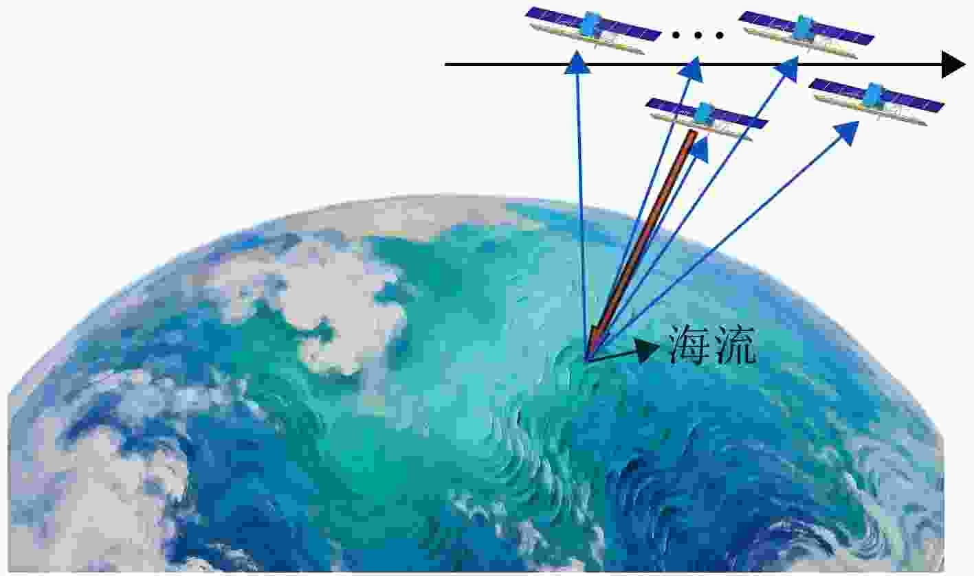
图 1 一发M 收星座在轨测流示意图
Figure 1. Schematic diagram of on-orbit current measurement of the M receiving constellation
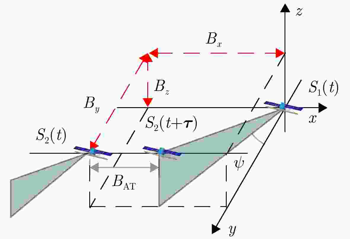
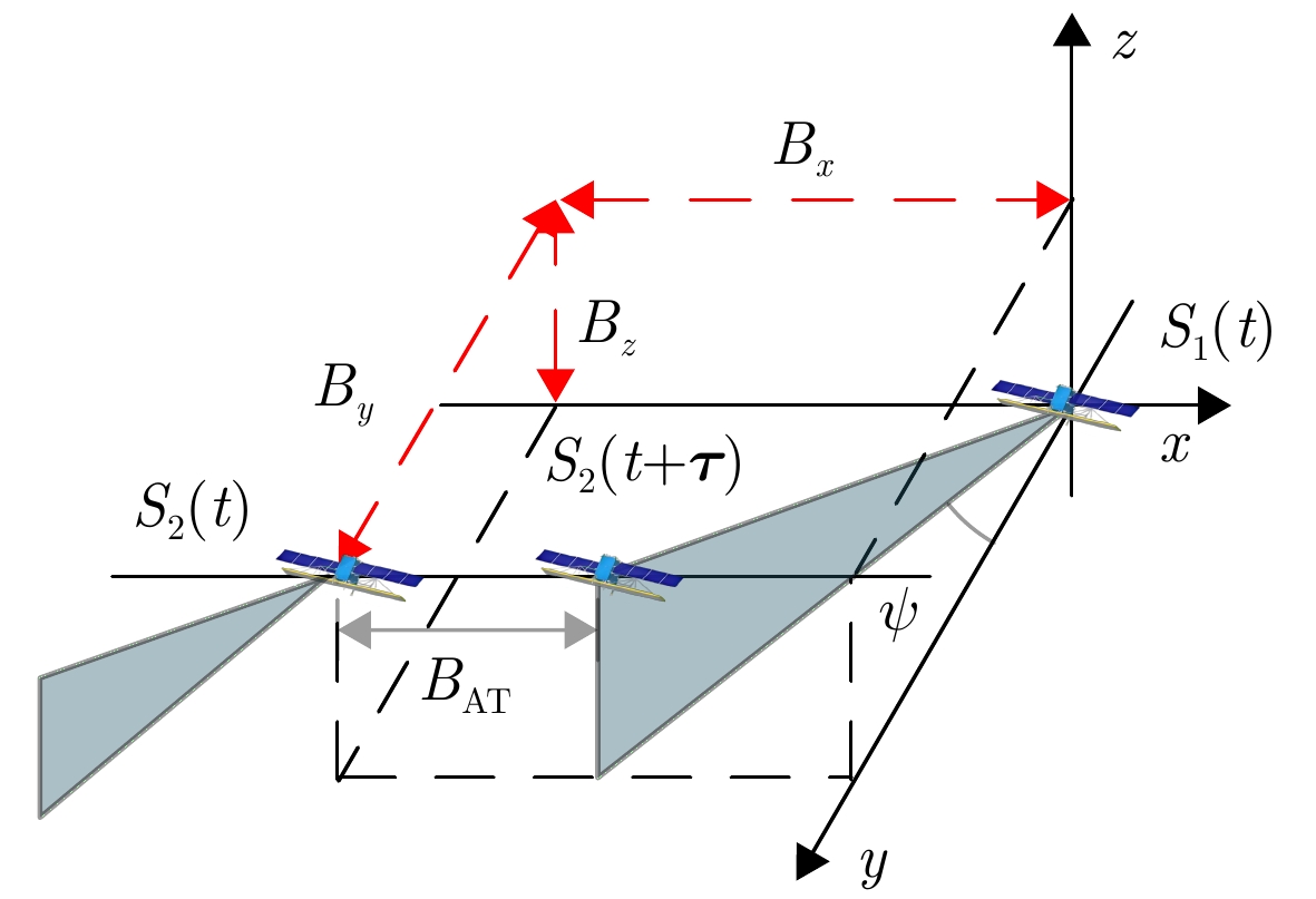
图 2 混合基线斜视卫星几何示意图
Figure 2. Schematic diagram of the geometry of a hybrid baseline strabismus satellite
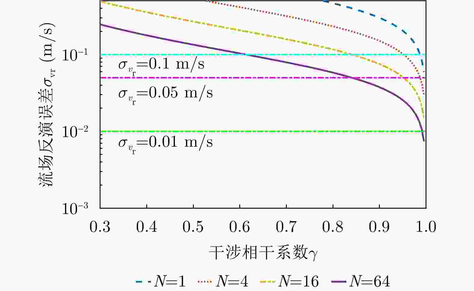
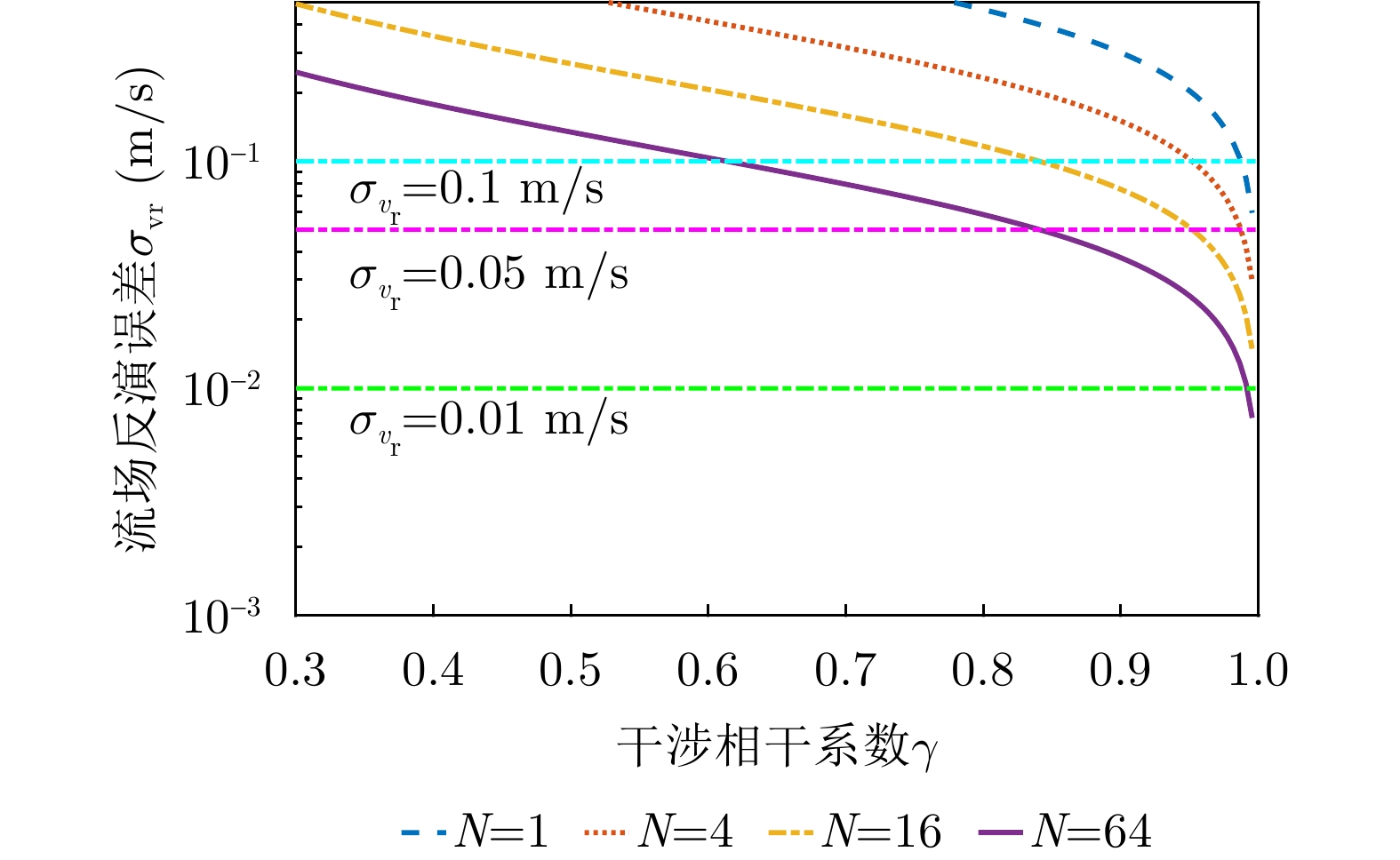
图 3 不同多视数,流场测量误差随相干系数变化
Figure 3. OSC measurement error variation with coherence coefficient under different multi-look numbers
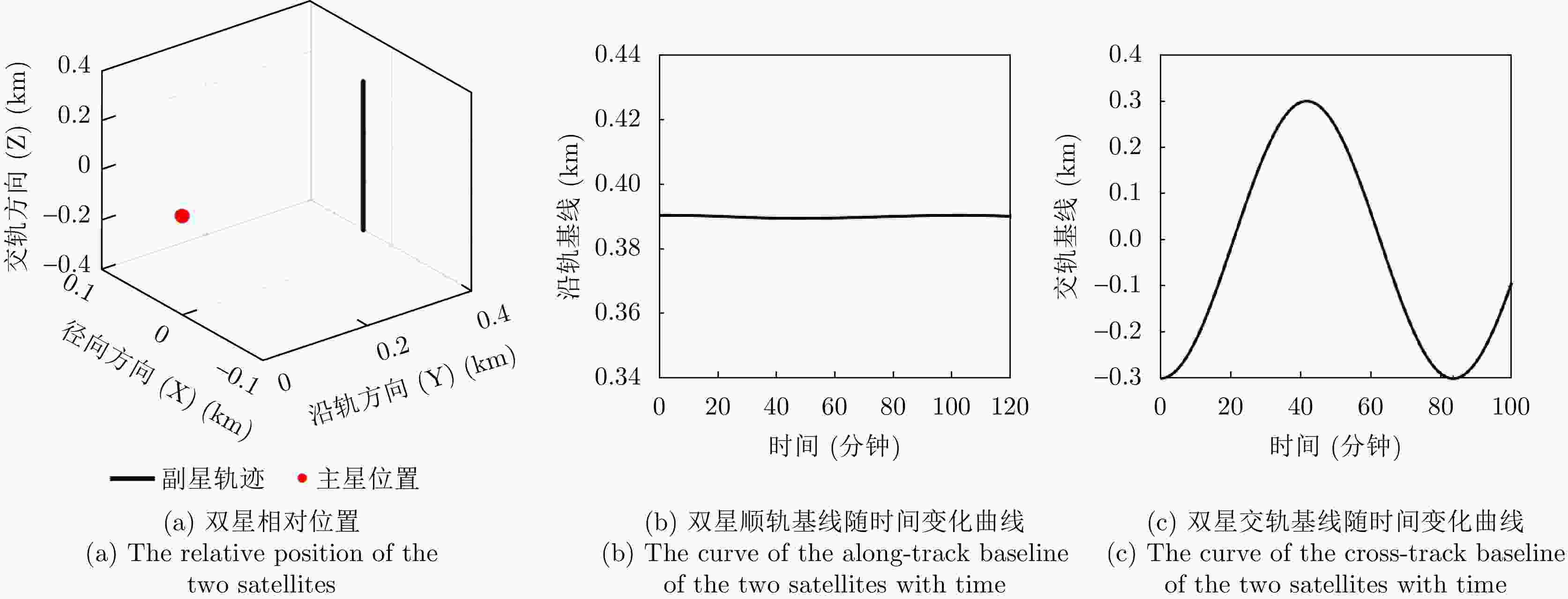
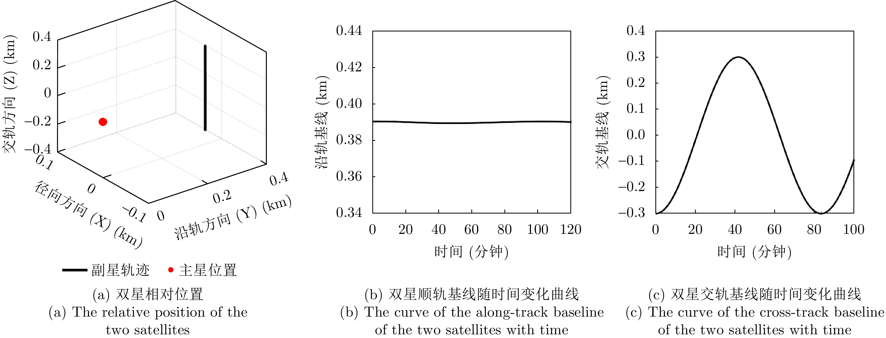
图 4 一个轨道周期交轨钟摆双星相对位置和基线示意图
Figure 4. Schematic diagram of relative position and baseline of pendulum
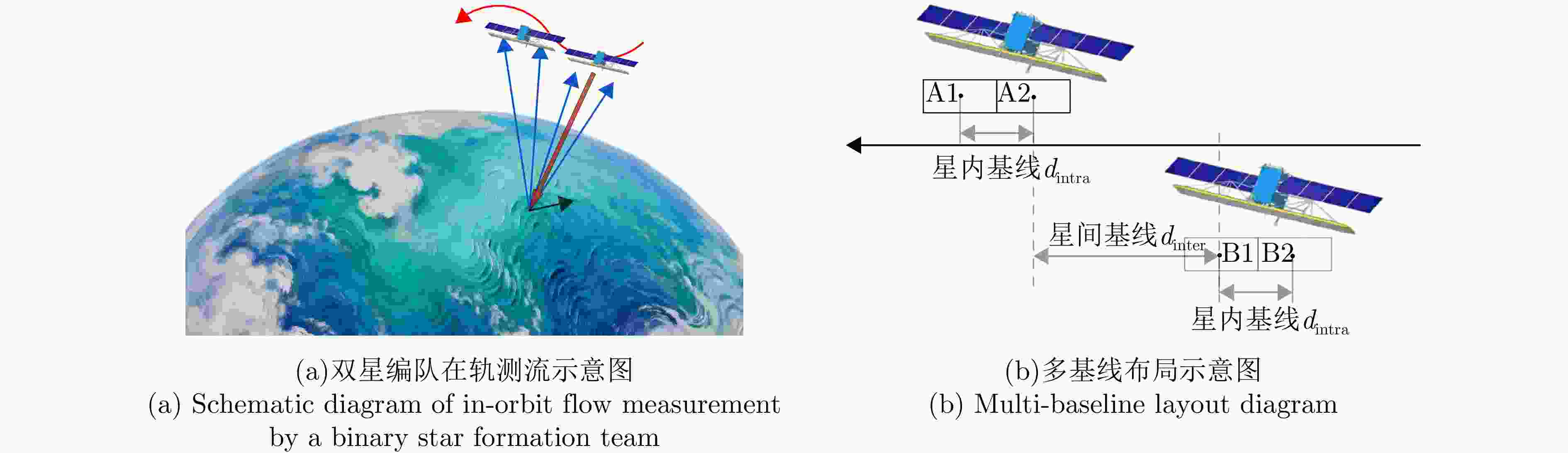
图 5 一种典型分布式SAR卫星系统几何构型示意图
Figure 5. Schematic illustration of a representative geometric configuration for a distributed SAR system
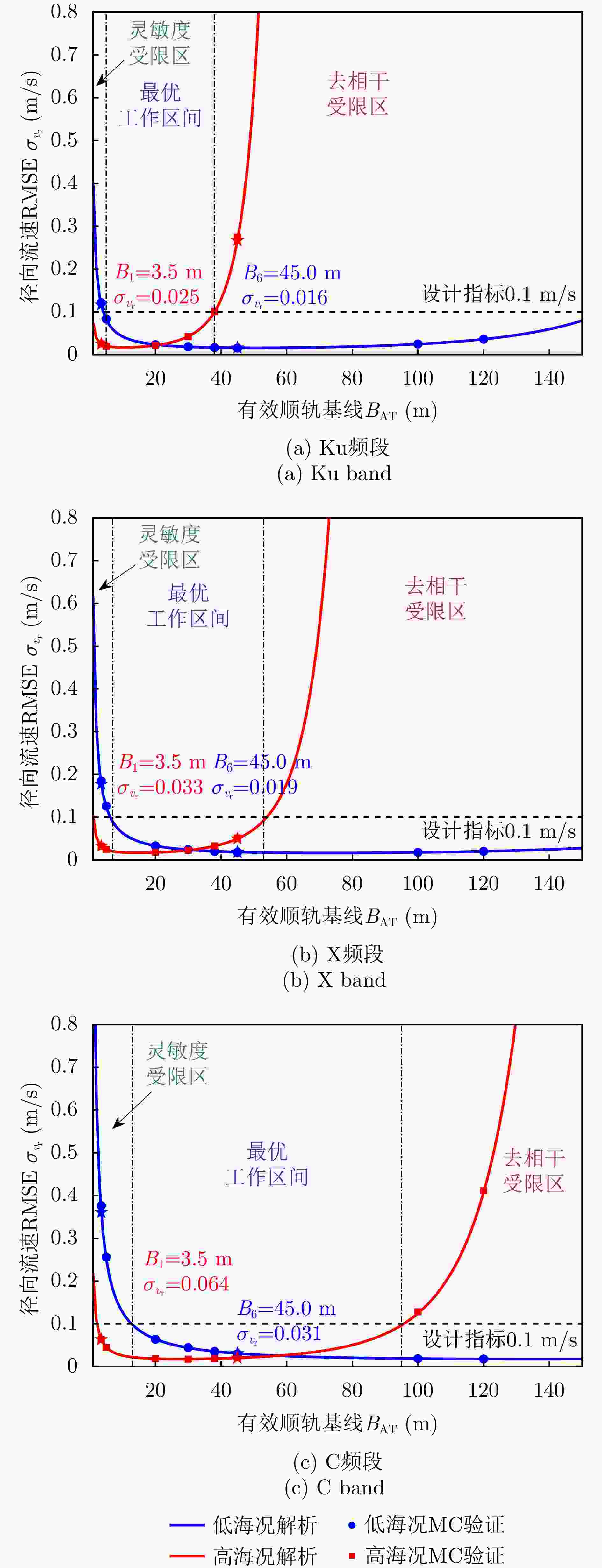
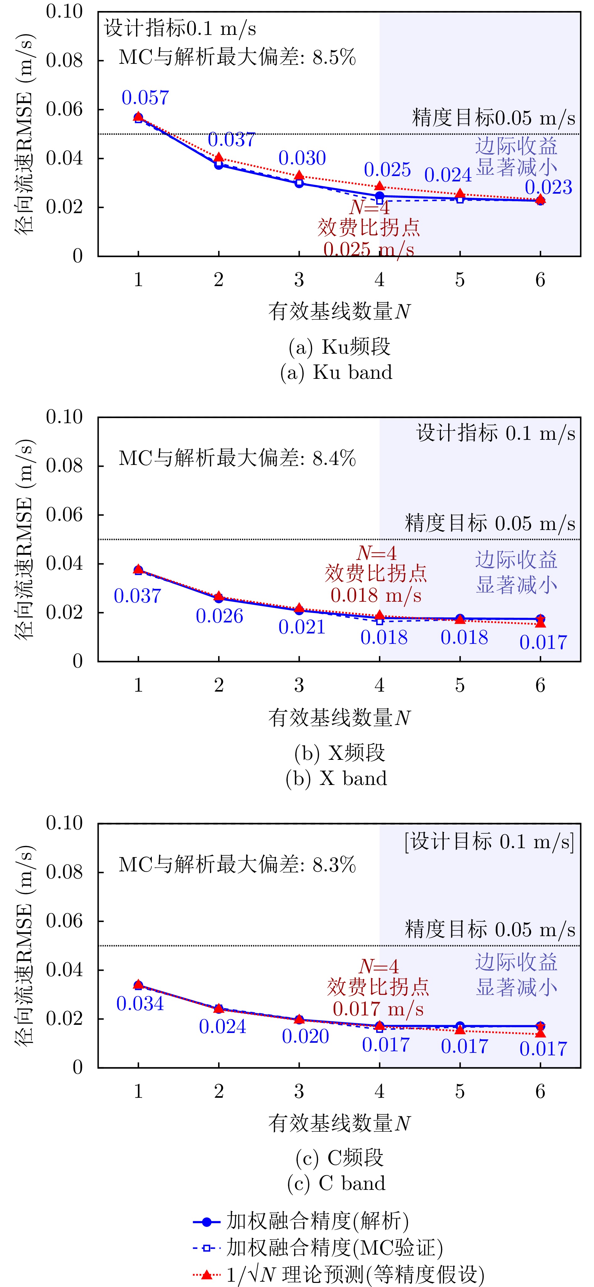
图 6 单基线流速测量RMSE随有效基线长度变化示意图
Figure 6. Single-baseline velocity measurement RMSE variation with effective baseline length
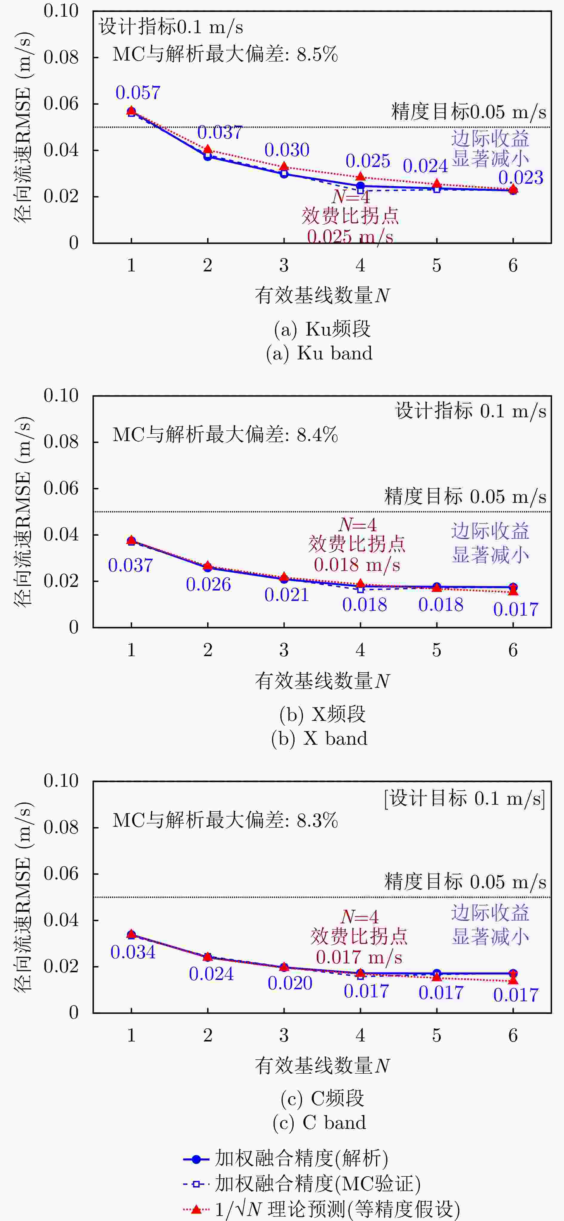
图 7 多基线加权融合精度随基线数量的收敛特性示意图
Figure 7. Convergence characteristics of multi-baseline weighted fusion accuracy with the number of baselines
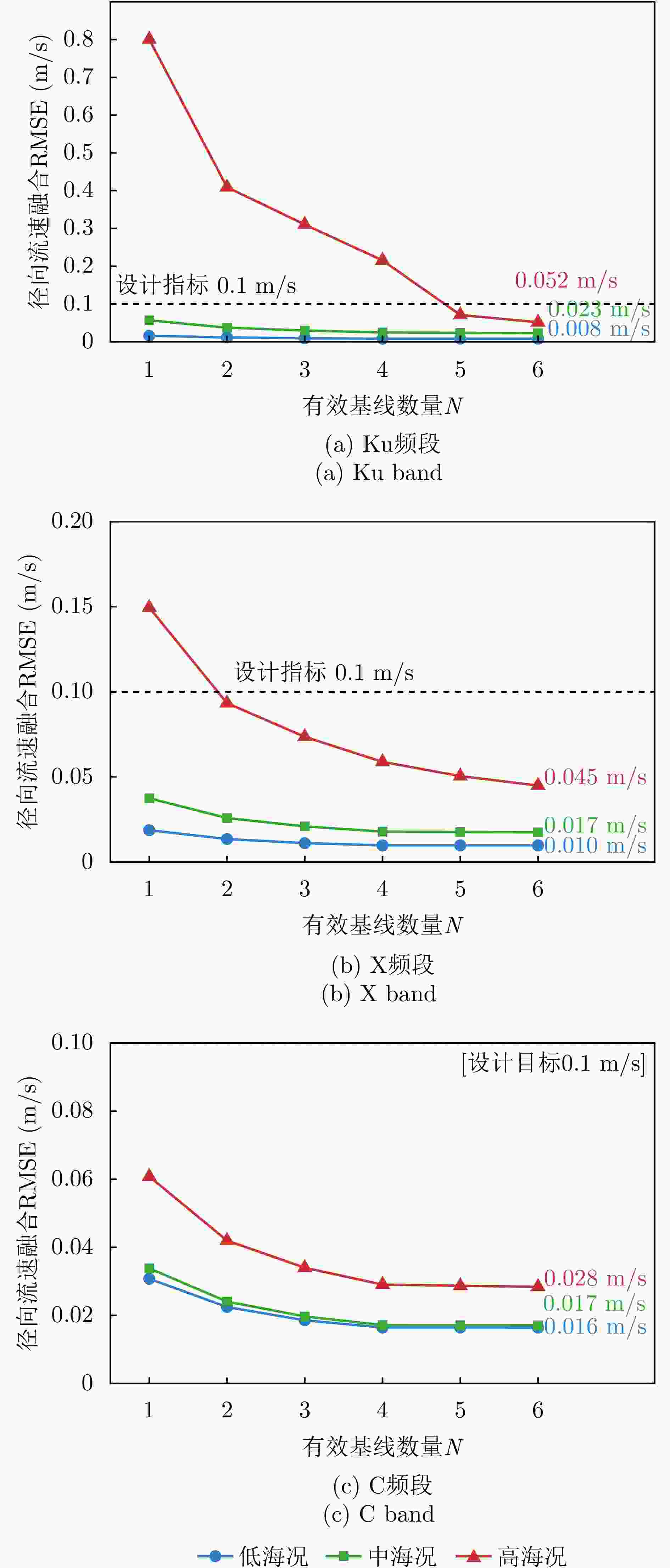
图 8 不同海况下多基线加权融合精度随基线数量变化曲线示意图
Figure 8. Schematic of the variation curve of multi-baseline weighted fusion accuracy with baseline number under different sea states
表 1 交轨钟摆双星编队轨道六根数
Table 1. The orbital elements of the pendulum
卫星 半长轴(km) 离心率 轨道倾角(°) 近地点辐角(°) 升交点赤经(°) 平近点角(°) 主星 7133.137 0.0001 97.4 0 0 0 辅星 7133.137 0.0001 97.4 0 0.0024 0.0031  下载: 导出CSV
表 2 系统仿真参数
Table 2. System simulation parameters
参数 数值 波长$ \lambda $ 0.022 m 卫星飞行速度$ {V}_{\text{s}} $ 7400 m/s斜视角$ \psi $ 45° 入射角$ {\theta }_{{i}} $ 30° 轨道高度$ {H} $ 755 km 风速$ {U}_{10} $ 3~12 m/s 径向流速$ {v}_{{\mathrm{r}}} $ 0.05~2.00 m/s 海面散射系数$ {\sigma }^{0} $ −12.5~−6.2 dB 噪声等效后向散射系数NESZ −20 dB 等效多视数$ {N}_{\text{L}} $ 1600 处理去相干$ {\gamma }_{\text{proc}} $ 0.98 垂直基线去相干$ {\gamma }_{\text{B}} $ 0.97
下载: 导出CSV
表 3 6条基线时间去相干系数汇总表
Table 3. Summary of time decorrelation coefficients for six rear-vew baselines
基线 天线对 物理基线长度(m) 有效顺轨基线长度 时间基线(ms) $ {\gamma }_{\text{temp}} $ 适用场景 $ {\text{B}}_{1} $ A1-A2 3.5 159 $ \lambda $ 0.473 0.992 全海况,高相干 $ {\text{B}}_{2} $ A2-B1 338 1727 $ \lambda $5.135 0.377 中-低海况 $ {\text{B}}_{3} $ B1-B2 3.5 159 $ \lambda $ 0.473 0.992 全海况,高相干 $ {\text{B}}_{4} $ A1-B1 341.5 1886 $ \lambda $ 5.608 0.313 中-低海况 $ {\text{B}}_{5} $ A2-B2 341.5 1886 $ \lambda $ 5.608 0.313 中-低海况 $ {\text{B}}_{6} $ A1-B2 345 2045 $ \lambda $ 6.081 0.255 中-低海况,高测流敏感性
下载: 导出CSV
表 4 各干涉通道总相干性对比表
Table 4. Verification of total coherence for each interferometric channel
通道 海况$ {U}_{10} $ (m/s) $ {\gamma }_{\text{SNR}} $ $ {\gamma }_{\text{temp}} $ $ {\gamma }_{\text{total}} $ 是否满足 $ \geq 0.3 $ 短基线(B1) 3 0.85 1.00 0.81 √ 7 0.93 0.99 0.88 √ 12 0.96 0.98 0.89 √ 长基线(B6) 3 0.85 0.78 0.63 √ 7 0.93 0.25 0.23 × 12 0.96 0.02 0.02 ×
下载: 导出CSV
表 5 各通道干涉相位模糊约束对比表
Table 5. Verification of interferometric phase ambiguity constraints for each channel
通道 $ {\phi }_{\text{max}} $ (rad) $ {\phi }_{\text{max}} \lt \text{π} $ 备注 短(B1) 0.27 √ 高相干,无模糊 中(B2) 2.93 √ 接近$ \text{π} $,利用B1解缠 长(B6) 3.47 × 超出$ \text{π} $,利用B1/B2逐级解缠
下载: 导出CSV
表 6 各通道径向流速测量精度对比表
Table 6. Verification of phase ambiguity constraints for each channel
通道 $ {\gamma }_{\text{total}} $ $ {\sigma }_{\phi } $ (rad) $ {\sigma }_{{{v}_{{\mathrm{r}}}}} $ (m/s) 备注 短基线(B1) 0.88 0.013 0.096 高相干,低测流敏感性 长基线(B6) 0.23 0.102 0.059 低相干,高测流敏感性 融合(等效) — — 0.027 六基线加权融合后精度
下载: 导出CSV
-
[1] AMANI M, GHORBANIAN A, ASGARIMEHR M, et al. Remote sensing systems for ocean: A review (Part 1: Passive systems)[J]. IEEE Journal of Selected Topics in Applied Earth Observations and Remote Sensing, 2022, 15: 210–234. doi: 10.1109/JSTARS.2021.3130789. [2] AMANI M, MOHSENI F, LAYEGH N F, et al. Remote sensing systems for ocean: A review (Part 2: Active systems)[J]. IEEE Journal of Selected Topics in Applied Earth Observations and Remote Sensing, 2022, 15: 1421–1453. doi: 10.1109/JSTARS.2022.3141980. [3] AMANI M, MEHRAVAR S, ASIYABI R M, et al. Ocean remote sensing techniques and applications: A review (Part II)[J]. Water, 2022, 14(21): 3401. doi: 10.3390/w14213401. [4] ZHANG Qingjun, FAN Huangjiang, QIN Yuxiao, et al. Advances in interferometric synthetic aperture radar technology and systems and recent advances in Chinese SAR missions[J]. Sensors, 2025, 25(15): 4616. doi: 10.3390/s25154616. [5] 邓云凯, 张衡, 范怀涛, 等. 面向综合环境监测的星载SAR技术发展[J]. 中国空间科学技术, 2023, 43(2): 32–46. doi: 10.16708/j.cnki.1000-758X.2023.0018.DENG Yunkai, ZHANG Heng, FAN Huaitao, et al. Forthcoming development trend of spaceborne SAR technology for earth environment monitoring[J]. Chinese Space Science and Technology, 2023, 43(2): 32–46. doi: 10.16708/j.cnki.1000-758X.2023.0018. [6] DU Yanlei, CHONG Jinsong, YIN Junjun, et al. Effect of current-wave interaction on ocean surface current retrieval using Doppler Centroid Anomaly (DCA) method[C]. 2024 IEEE International Geoscience and Remote Sensing Symposium, Athens, Greece, 2024: 5969–5972. doi: 10.1109/IGARSS53475.2024.10642010. [7] GOLDSTEIN R M and ZEBKER H A. Interferometric radar measurement of ocean surface currents[J]. Nature, 1987, 328(6132): 707–709. doi: 10.1038/328707a0. [8] WOLLSTADT S, LÓPEZ-DEKKER P, DE ZAN F, et al. Design principles and considerations for spaceborne ATI SAR-based observations of ocean surface velocity vectors[J]. IEEE Transactions on Geoscience and Remote Sensing, 2017, 55(8): 4500–4519. doi: 10.1109/TGRS.2017.2692880. [9] CALDARELLA N, LOPEZ-DEKKER P, PRATS-IRAOLA P, et al. Retrieval of wind and total surface current vectors using experimental bidirectional along-track interferometric TanDEM-X data[J]. IEEE Transactions on Geoscience and Remote Sensing, 2022, 60: 5223412. doi: 10.1109/TGRS.2022.3147490. [10] ROMEISER R, RUNGE H, SUCHANDT S, et al. Quality assessment of surface current fields from TerraSAR-X and TanDEM-X along-track interferometry and Doppler centroid analysis[J]. IEEE Transactions on Geoscience and Remote Sensing, 2014, 52(5): 2759–2772. doi: 10.1109/TGRS.2013.2265659. [11] ROMEISER R, SUCHANDT S, RUNGE H, et al. First analysis of TerraSAR-X along-track InSAR-derived current fields[J]. IEEE Transactions on Geoscience and Remote Sensing, 2010, 48(2): 820–829. doi: 10.1109/TGRS.2009.2030885. [12] RASHID M and GIERULL C H. Retrieval of ocean surface radial velocities with RADARSAT-2 along-track interferometry[J]. IEEE Journal of Selected Topics in Applied Earth Observations and Remote Sensing, 2021, 14: 9597–9608. doi: 10.1109/JSTARS.2021.3110198. [13] YUAN Xinzhe, LIN Mingsen, HAN Bing, et al. Observing sea surface current by gaofen-3 satellite along-track interferometric SAR experimental mode[J]. IEEE Journal of Selected Topics in Applied Earth Observations and Remote Sensing, 2021, 14: 7762–7770. doi: 10.1109/JSTARS.2021.3099105. [14] GOMMENGINGER C, CHAPRON B, MARQUEZ J, et al. Wavemill: A new mission for high-resolution mapping of total ocean surface current vectors[C]. The 10th European Conference on Synthetic Aperture Radar, Berlin, Germany, 2014: 1–4. [15] MARTIN A, MACEDO K, PORTABELLA M, et al. OSCAR: A new airborne instrument to image ocean-atmosphere dynamics at the sub-mesoscale: Instrument capabilities and the SEASTARex airborne campaign[C]. EGU General Assembly 2023, Vienna, Austria, 2023: EGU23–9940. doi: 10.5194/egusphere-egu23-9940. [16] LÓPEZ-DEKKER P, ROTT H, PRATS-IRAOLA P, et al. Harmony: An earth explorer 10 mission candidate to observe land, ice, and ocean surface dynamics[C]. 2019 IEEE International Geoscience and Remote Sensing Symposium, Yokohama, Japan, 2019: 8381–8384. doi: 10.1109/IGARSS.2019.8897983. [17] HU Cheng, LI Yuanhao, CHEN Zhiyang, et al. Distributed spaceborne SAR: A review of systems, applications, and the road ahead[J]. IEEE Geoscience and Remote Sensing Magazine, 2025, 13(2): 329–361. doi: 10.1109/MGRS.2025.3535412. [18] 王意军, 宋天祎, 李威, 等. 基于去相干敏感因子的多基线PolInSAR植被高度反演方法[J]. 上海航天(中英文), 2021, 38(6): 21–27. doi: 10.19328/j.cnki.2096-8655.2021.06.003.WANG Yijun, SONG Tianyi, LI Wei, et al. Multi-baseline PolInSAR vegetation height inversion method based on decorrelation sensitivity factor[J]. Aerospace Shanghai, 2021, 38(6): 21–27. doi: 10.19328/j.cnki.2096-8655.2021.06.003. [19] SLETTEN M A and TOPORKOV J V. A multichannel approach to ocean surface current measurement with an ultrawideband ATI-SAR[J]. IEEE Transactions on Geoscience and Remote Sensing, 2025, 63: 5211110. doi: 10.1109/TGRS.2025.3568267. [20] GUO Huancheng, WANG Zhibin, LI Zhenfang, et al. Wide-swath ocean current measurement based on MIMO along-track interferometry SAR[J]. IEEE Transactions on Geoscience and Remote Sensing, 2024, 62: 5221216. doi: 10.1109/TGRS.2024.3452120. [21] BAMLER R and HARTL P. Synthetic aperture radar interferometry[J]. Inverse Problems, 1998, 14(4): R1–R54. doi: 10.1088/0266-5611/14/4/001. [22] 胡瑞贤, 张昭, 骆成. 一种分布式卫星系统基线优化设计方法[J]. 系统工程与电子技术, 2023, 45(8): 2423–2437. doi: 10.12305/j.issn.1001-506X.2023.08.16.HU Ruixian, ZHANG Zhao, and LUO Cheng. A baseline optimization method for distributive satellites system[J]. Systems Engineering and Electronics, 2023, 45(8): 2423–2437. doi: 10.12305/j.issn.1001-506X.2023.08.16. [23] 王祎笛, 王宇, 张云俊, 等. 超长基线星载干涉SAR概念与体制[J]. 雷达学报(中英文), 2026, 15(1): 215–237. doi: 10.12000/JR25220.WANG Yidi, WANG Robert, ZHANG Yunjun, et al. The concept and system of very large baseline spaceborne interferometric synthetic aperture radar[J]. Journal of Radars, 2026, 15(1): 215–237. doi: 10.12000/JR25220. [24] 邵晓巍, 张德新, 陈筠力, 等. 分布式卫星编队设计与控制[M]. 北京: 国防工业出版社, 2021: 3–18.SHAO Xiaowei, ZHANG Dexin, CHEN Yunli, et al. Design and Control of Distributed Satellite Formation[M]. Beijing: National Defense Industry Press, 2021: 3–18. [25] PERAL E, ESTEBAN-FERNÁNDEZ D, RODRÍGUEZ E, et al. KaRIn, the Ka-band radar interferometer of the SWOT mission: Design and in-flight performance[J]. IEEE Transactions on Geoscience and Remote Sensing, 2024, 62: 5214127. doi: 10.1109/TGRS.2024.3405343. [26] 袁新哲, 王小青, 赵良波, 等. 顺轨干涉合成孔径雷达海表面流测量原理、方法与信号仿真[M]. 北京: 海洋出版社, 2022: 84–92.YUAN Xinzhe, WANG Xiaoqing, ZHAO Liangbo, et al. Principles, Methods, and Signal Simulation of Along-Track Interferometric Synthetic Aperture Radar for Sea Surface Current Measurement[M]. Beijing: China Ocean Press, 2022: 84–92. [27] CARANDE R E. Estimating ocean coherence time using dual-baseline interferometric synthetic aperture radar[J]. IEEE Transactions on Geoscience and Remote Sensing, 1994, 32(4): 846–854. doi: 10.1109/36.298012. [28] 刘旗, 郭瑞, 王佳佳, 等. 低仰角目标高精度波束空间DOA估计方法[J]. 雷达学报(中英文), 2026, 15(3): 860–875. doi: 10.12000/JR25173.LIU Qi, GUO Rui, WANG Jiajia, et al. A high-accuracy beamspace DOA estimation method for low-elevation angle targets[J]. Journal of Radars, 2026, 15(3): 860–875. doi: 10.12000/JR25173. [29] ROMEISER R and RUNGE H. Theoretical evaluation of several possible along-track InSAR modes of TerraSAR-X for ocean current measurements[J]. IEEE Transactions on Geoscience and Remote Sensing, 2007, 45(1): 21–35. doi: 10.1109/TGRS.2006.885405. [30] PETERSON E H, FOTOPOULOS G, and ZEE R E. A feasibility assessment for low-cost InSAR formation-flying microsatellites[J]. IEEE Transactions on Geoscience and Remote Sensing, 2009, 47(8): 2847–2858. doi: 10.1109/TGRS.2009.2017521. [31] LACHAISE M, FRITZ T, and BREIT H. InSAR processing and dual-baseline phase unwrapping for global TanDEM-X DEM generation[C]. 2014 IEEE Geoscience and Remote Sensing Symposium, Quebec, Canada, 2014: 2229–2232. doi: 10.1109/IGARSS.2014.6946912. [32] GUO Mingde, CHEN Kunshan, YANG Ying, et al. Effective surface roughness in radar ocean backscattering[J]. IEEE Transactions on Geoscience and Remote Sensing, 2023, 61: 2004113. doi: 10.1109/TGRS.2023.3306464. -


计量
- 文章访问数:
- HTML全文浏览量:
- PDF下载量:
- 被引次数: 0

