
 作者中心
作者中心 专家审稿
专家审稿 责编办公
责编办公 编辑办公
编辑办公
Aircraft Wake Vortex Observations in Hong Kong
DOI: 10.12000/JR17072 cstr: 32380.14.JR17072
-
摘要: 香港国际机场是世界上其中一个最繁忙的机场,其总航班升降量在2016年已超越400,000次。香港天文台除为香港国际机场提供航空气象服务外,近年亦开始利用短程激光雷达作飞机尾涡观测,并取得了初步的成果。该文介绍天文台在2014至2016年间的观测计划及初步数据分析结果,亦讨论香港国际机场飞机尾涡监测和预报技术的发展动向。Abstract: The Hong Kong International Airport (HKIA) is among the busiest airports in the world, with total aircraft movement exceeding 400,000 in 2016. The Hong Kong Observatory (HKO), provider of aviation meteorological services to HKIA, has recently begun making the first sets of aircraft wake vortex observations at HKIA using short-range LIDARs. This paper briefly describes the preliminary observation results obtained from field measurements between 2014 and 2016, and discusses the way forward on the monitoring and prediction of wake vortex behaviour in Hong Kong.
-

Figure 1. Schematic diagram of the terrain (contoured at 100 m separation) and major meteorological instruments surrounding the Hong Kong International Airport

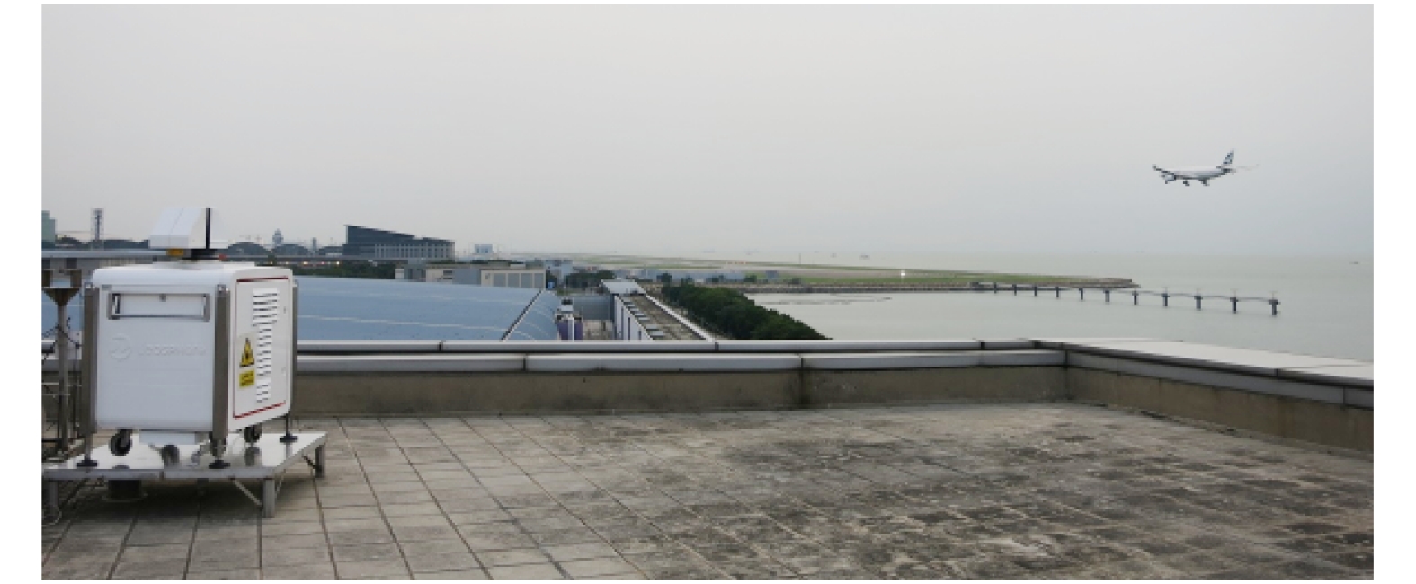
Figure 2. The temporary unit of short-range LIDAR overlooking the arrival glide path of corridor 25RA at HKIA during the 2014 field campaign

Figure 3. Scanning strategies employed during the short-range LIDAR field campaign in summer 2014

Figure 4. Sample sequence of wake vortex evolution (highlighted) captured by a short-range LIDAR over 25RA during the 2014 field campaign

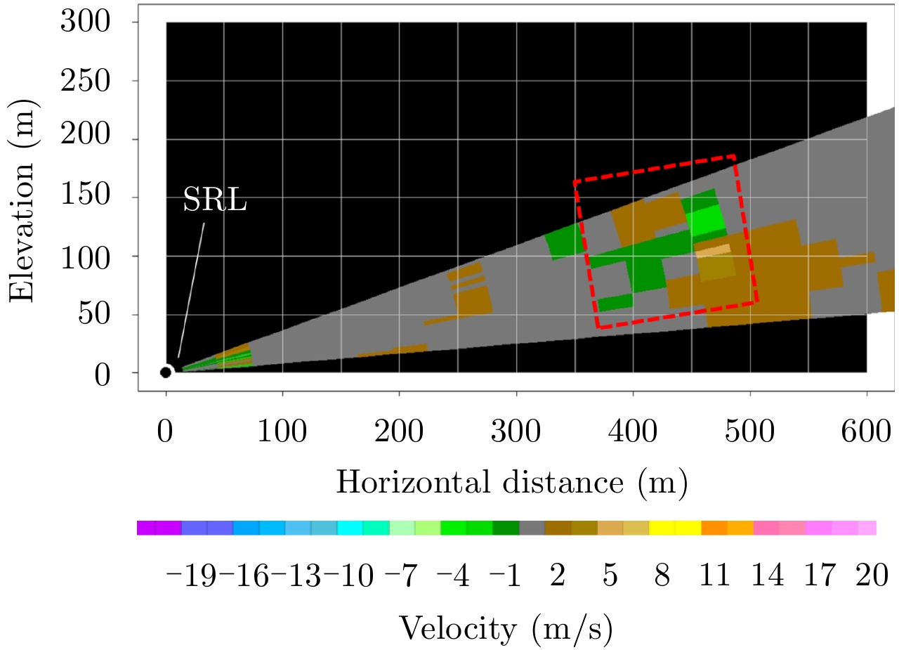
Figure 5. Scatterplot of estimated advection speed of identified wake vortices during the 2014 field campaign (vertical axis) against background wind speed from a nearby anemometer (horizontal axis). Please refer to the main text for more detailed descriptions

Figure 6. Scanning strategy employed for departure-corridor wake vortex observations during the SRL field campaign in 2015

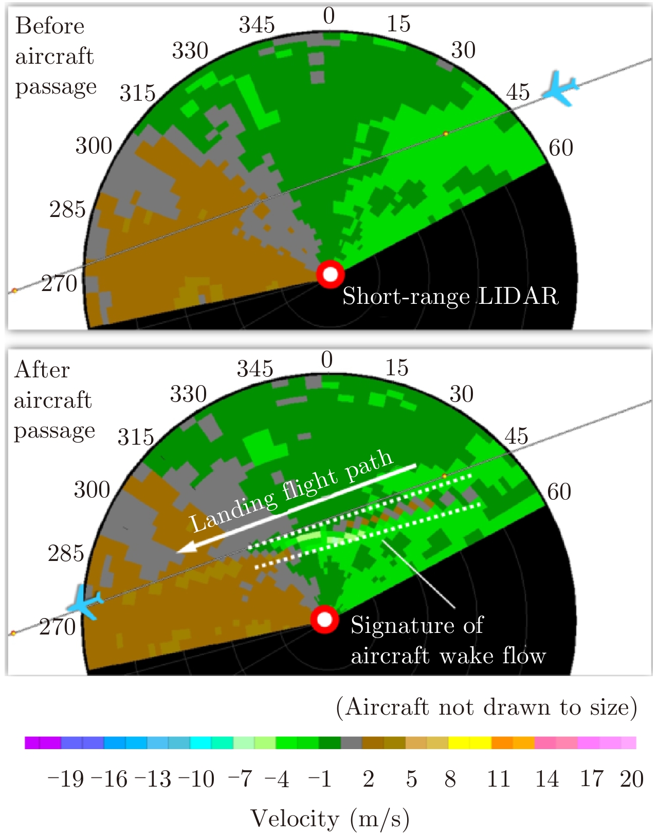
Figure 7. Sample snapshot of a pair of wake vortices (highlighted) observed over corridor 25LD during the SRL field campaign in 2015

Figure 8. Sample normalised spectral intensities obtained from the permanent SRL unit of HKO during late 2016. The sharp jump near the middle of the plot corresponds to rough occurrence location of the observed wake vortices

Figure 9. Sample sequence of short-range LIDAR fixed-elevation scans (3° elevation; each planar scan completed in 20–30 seconds) during a suspected case of low-level windshear encounter related to remnant wake vortices. The trailing arrival aircraft would report an encounter of significant low-level windshear
-
[1] Hallock J N. Aircraft wake vortices: An assessment of the current situation[R]. U.S. Department of Transportation Report. DOT-FAA-RD-90-29. Washington, D.C.: U.S. Department of Transportation, 1991: 59. [2] Rubin W L. Radar-acoustic detection of aircraft wake vortices[J]. Journal of Atmospheric and Oceanic Technology, 2000, 17(8): 1058–1065. DOI: 10.1175/1520-0426(2000)017<1058:RADOAW>2.0.CO;2 [3] Holzäpfel F, Gerz T, Köpp F, et al. Strategies for circulation evaluation of aircraft wake vortices measured by Lidar[J]. Journal of Atmospheric and Oceanic Technology, 2003, 20(8): 1183–1195. DOI: 10.1175/1520-0426(2003)020<1183:SFCEOA>2.0.CO;2 [4] Liu Zhong-xun, Jeannin N, Vincent F, et al. Modeling the radar signature of raindrops in aircraft wake vortices[J]. Journal of Atmospheric and Oceanic Technology, 2013, 30(3): 470–484. DOI: 10.1175/JTECH-D-11-00220.1 [5] Holzäpfel F and Robins R E. Probabilistic two-phase aircraft wake vortex model: Application and assessment[J]. Journal of Aircraft, 2004, 41(5): 1117–1126. DOI: 10.2514/1.2280 [6] Holzäpfel F, Kladetzke J, Amelsberg S, et al. Aircraft wake vortex scenarios simulation package for takeoff and departure[J]. Journal of Aircraft, 2009, 46(2): 713–717. DOI: 10.2514/1.39346 [7] ICAO. Procedures for air navigation services—air traffic management (Doc 4444)[Z]. 2016, 5: 1–36 (Technical document of the International Civil Aviation Organisation). [8] EUROCONTROL. European wake vortex mitigation benefits study (EuroBen)[Z]. High Level Benefits Analysis & Systemic Analysis, 2005 (Technical report of EUROCONTROL). [9] Tittsworth J A, Lang S R, Johnson E J, et al.. Federal aviation administration wake turbulence program-recent highlights[C]. 57th Air Traffic Control Association (ATCA) Annual Conference & Exposition, Cambridge, MA, USA, 2012. [10] Federal Aviation Administration. Wake turbulence recategorization[Z]. Order JO 7110.659C, 2016 (Administrative order form FAA of USA). [11] Treve V and Rooseleer F. RECAT-EU proposal, validation and consultation[R]. WakeNet-EU, EUROCONTROL Experimental Centre, Bretigny, France, 2014. [12] Morris C, Peters J and Choroba P. Validation of the time based separation concept at London Heathrow Airport[C]. Tenth USA/Europe Air Traffic Management Research and Development Seminar, 2013. [13] French Civil Aviation Authority. Implementation of the RECAT-EU wake turbulence separation scheme at Paris Charles de Gaulle, Paris-le Bourget and Pontoise-Cormeilles-en-Vexin airports from March 22nd 2016[R]. AIC France A 03/16. 2016. [14] Federal Aviation Administration. Re-categorization (RECAT) of FAA wake turbulence separation categories at specific airports[R]. SAFO 12007. Washington, DC: SAFO, 2013. [15] Airport Authority Hong Kong. Hong Kong international airport fact sheet[EB/OL]. http://www.hongkongairport.com/eng/media/facts-figures/facts-sheets.html, 2016. [16] Airport Authority Hong Kong. Finalized civil international air traffic statistics at HKIA, Year 2016[EB/OL]. http://www.hongkongairport.com/eng/pdf/business/statistics/2016e.pdf, 2016. [17] Shun C M and Chan P W. Applications of an infrared Doppler Lidar in detection of wind shear[J]. Journal of Atmospheric and Oceanic Technology, 2008, 25(5): 637–655. DOI: 10.1175/2007JTECHA1057.1 [18] Hon K K, Chan P W, Chiu Y Y, et al.. Application of short-range LIDAR in early alerting for low-level windshear and turbulence at Hong Kong International Airport[J]. Advances in Meteorology, 2014, 2014: Article ID 162748. [19] Hon K K. First wake vortex measurements at the Hong Kong International Airport[EB/OL]. News bulletin for the aviation community, Hong Kong Observatory. http://www.hko.gov.hk/aviat/outreach/32nd/wakevortex.htm, 2015, January. [20] Smalikho I N, Banakh V A, Holzäpfel F, et al. Method of radial velocities for the estimation of aircraft wake vortex parameters from data measured by coherent Doppler Lidar[J]. Optics Express, 2015, 23(19): A1194–A1207. DOI: 10.1364/OE.23.0A1194 [21] Loaec S, Thobois L, Cariou J P, et al.. Monitoring wake vortices with a scanning Doppler LIDAR[C]. Proceedings of the 9th International Symposium on Tropospheric Profiling, 2012. [22] Smalikho I, Köpp F, and Rahm S. Measurement of atmospheric turbulence by 2-μm Doppler Lidar[J]. Journal of Atmospheric and Oceanic Technology, 2005, 22(11): 1733–1747. DOI: 10.1175/JTECH1815.1 [23] Chan P W and Hon K K. Performance of super high resolution numerical weather prediction model in forecasting terrain-disrupted airflow at the Hong Kong International Airport: Case studies[J]. Meteorological Applications, 2016, 23(1): 101–114. DOI: 10.1002/met.2016.23.issue-1 [24] Hon K K and Chan P W. Sub-kilometer simulation of terrain-disrupted airflow at the Hong Kong International Airport-aviation applications and inter-comparison with LIDAR observations[C]. 16th Conference on Mountain Meteorology, 2014. [25] Wassaf H S, Tabrizi A, Wang F Y, et al.. Atmospheric turbulence effects on near-ground wake vortex demise[C]. 13th Conference on Aviation, Range and Aerospace Meteorology, 2008. [26] Chan P W. Generation of an eddy dissipation rate map at the Hong Kong International airport based on Doppler Lidar data[J]. Journal of Atmospheric and Oceanic Technology, 2011, 28(1): 37–49. DOI: 10.1175/2010JTECHA1458.1 -

 下载:
下载:


计量
- 文章访问数:
- HTML全文浏览量:
- PDF下载量:
- 被引次数: 0

