
 Submit Manuscript
 Peer Review
 Editor Work
2012 Vol. 1, No. 1
 Previous Issue
2012, 1(1): 1-10.
 Abstract
 2369KB
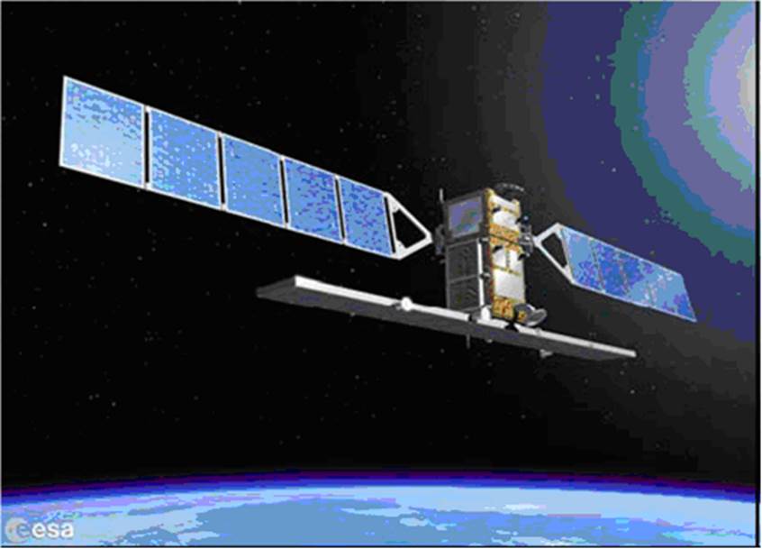
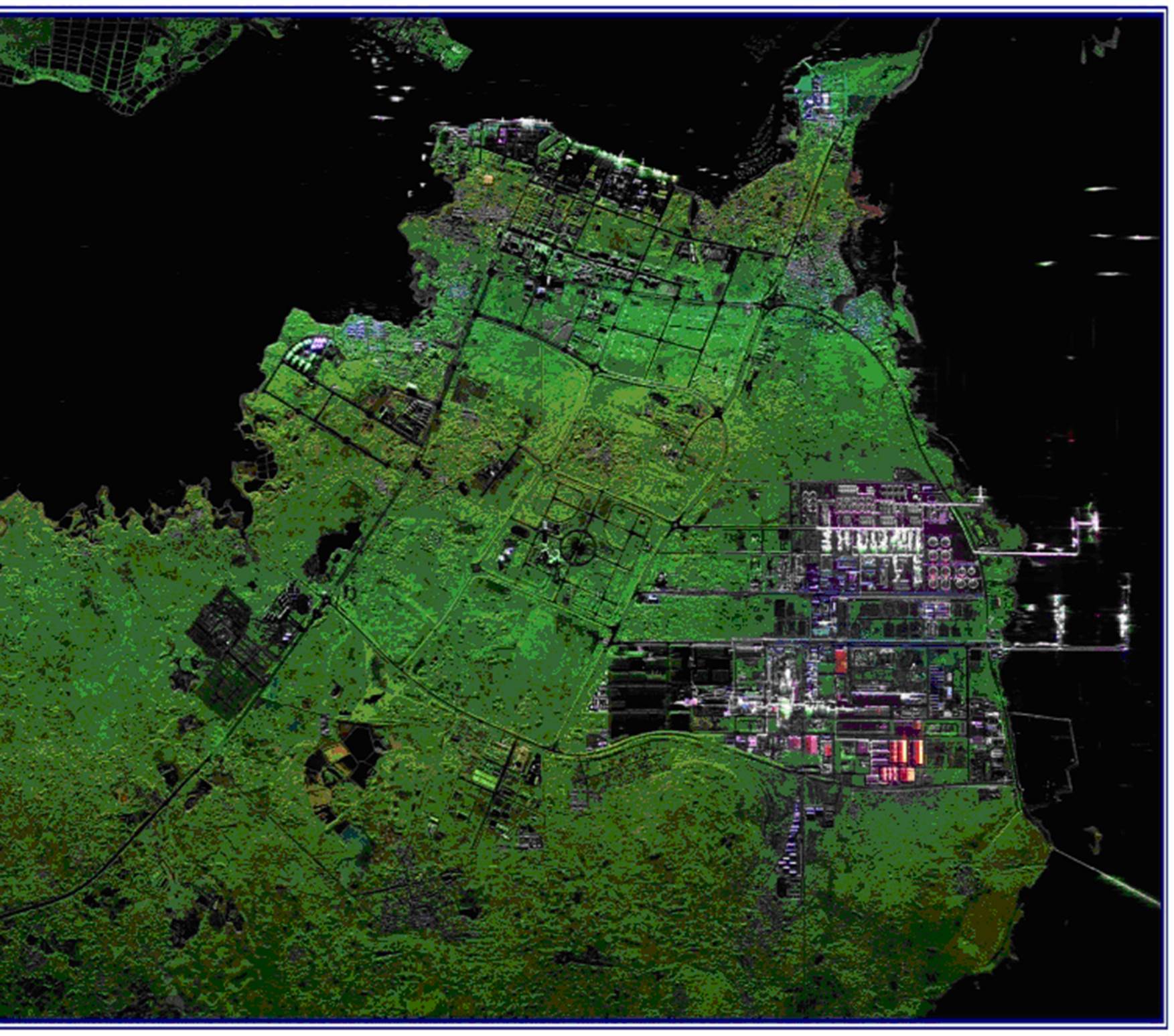
Spaceborne SAR, which is a kind of initiatively microwave imaging sensor, plays an important role in gathering information with its capability of all-day and all-weather imaging, and has become an indispensable sensor for observing the earth. With the development of SAR techniques, Spaceborne SAR has been provided with the ability of High-Resolution Wide-Swath, miniaturization with low cost, bistatic and multi-mode imaging, and Ground Moving Target Indicating (GMTI), so more accurate information about the culture could be obtained with lower cost. In the meantime, more technique problems with muliti-mode, new work system and complex environment are arising and needed to be solved. The main work of this paper is discussing the current situation and the future development of Spaceborne SAR.
Spaceborne SAR, which is a kind of initiatively microwave imaging sensor, plays an important role in gathering information with its capability of all-day and all-weather imaging, and has become an indispensable sensor for observing the earth. With the development of SAR techniques, Spaceborne SAR has been provided with the ability of High-Resolution Wide-Swath, miniaturization with low cost, bistatic and multi-mode imaging, and Ground Moving Target Indicating (GMTI), so more accurate information about the culture could be obtained with lower cost. In the meantime, more technique problems with muliti-mode, new work system and complex environment are arising and needed to be solved. The main work of this paper is discussing the current situation and the future development of Spaceborne SAR.


This paper gives the experimental research of HF Passive Bistatic Radar (HFPBR) based on Digital Radio Mondiale (DRM) digital AM broadcasting that have been first carried out in China, using the newly-developed all-digital active/passive integrated HF surface wave radar system. The principle, key techniques, experimental equipment, and preliminary results are introduced about this new radar system. Based on analysis of the measurement data, experimental results under different scenarios including surface-wave, sky-wave, and hybrid sky-surface propagation modes are presented, which have proved, for the first time worldwide, the technical feasibility of using DRM broadcasting signal for over-the-horizon detection by field experiment and formed the theoretical and experimental basis for the further development of HFPBR.
This paper gives the experimental research of HF Passive Bistatic Radar (HFPBR) based on Digital Radio Mondiale (DRM) digital AM broadcasting that have been first carried out in China, using the newly-developed all-digital active/passive integrated HF surface wave radar system. The principle, key techniques, experimental equipment, and preliminary results are introduced about this new radar system. Based on analysis of the measurement data, experimental results under different scenarios including surface-wave, sky-wave, and hybrid sky-surface propagation modes are presented, which have proved, for the first time worldwide, the technical feasibility of using DRM broadcasting signal for over-the-horizon detection by field experiment and formed the theoretical and experimental basis for the further development of HFPBR.
2012, 1(1): 19-27.
Viewing from the interaction between external and internal causes on the time scale of history, present and future, this paper analyzes and demonstrates the developing motivation and stage characteristics of radar technology. The external causes are interpreted as target, environment and mission, and the internal causes as information acquisition pattern, realization ability and resource utilization. The fundamental law of radar development is revealed as evolving stepwise from lower into higher dimension of detection through the aromorphosis of channel configuration, viewing angle and signal dimensionality, while the main innovation strategies of radar technology are summarized as modifying information acquisition pattern, enhancing realization ability and increasing utilized resources. Furthermore, the developing trends and main characteristics of future radar technology are deduced, and proposals for promoting future innovation and development are also presented.
Viewing from the interaction between external and internal causes on the time scale of history, present and future, this paper analyzes and demonstrates the developing motivation and stage characteristics of radar technology. The external causes are interpreted as target, environment and mission, and the internal causes as information acquisition pattern, realization ability and resource utilization. The fundamental law of radar development is revealed as evolving stepwise from lower into higher dimension of detection through the aromorphosis of channel configuration, viewing angle and signal dimensionality, while the main innovation strategies of radar technology are summarized as modifying information acquisition pattern, enhancing realization ability and increasing utilized resources. Furthermore, the developing trends and main characteristics of future radar technology are deduced, and proposals for promoting future innovation and development are also presented.
2012, 1(1): 28-35.
Blind zones and ambiguities in range and velocity measurement are two important issues in traditional pulse-Doppler radar. By generating random deviations with respect to a mean Pulse Repetition Interval (PRI), this paper proposes a novel algorithm of Moving Target Detection (MTD) based on the Compressed Sensing (CS) theory, in which the random deviations of the PRIare converted to the Restricted Isometry Property (RIP) of the observing matrix. The ambiguities of range and velocity are eliminated by designing the signal parameters. The simulation results demonstrate that this scheme has high performance of detection, and there is no ambiguity and blind zones as well. It can also shorten the coherent processing interval compared to traditional staggered PRI mode because only one pulse train is needed instead of several trains.
Blind zones and ambiguities in range and velocity measurement are two important issues in traditional pulse-Doppler radar. By generating random deviations with respect to a mean Pulse Repetition Interval (PRI), this paper proposes a novel algorithm of Moving Target Detection (MTD) based on the Compressed Sensing (CS) theory, in which the random deviations of the PRIare converted to the Restricted Isometry Property (RIP) of the observing matrix. The ambiguities of range and velocity are eliminated by designing the signal parameters. The simulation results demonstrate that this scheme has high performance of detection, and there is no ambiguity and blind zones as well. It can also shorten the coherent processing interval compared to traditional staggered PRI mode because only one pulse train is needed instead of several trains.
2012, 1(1): 36-42.
In the paper, a method of moving target detection and parameters estimation is proposed used for dual channels Wide Area Surveillance (WAS) radar based on high resolution Doppler Beam Sharpen (DBS) image. First, it analyzes characteristics of clutter and moving target return, and presents the ways of clutter suppression and moving target parameters estimation. Then, an approach to decrease errors of parameters estimation is proposed. At last, an effective approach to resolve the ambiguity caused during estimating moving targets parameters is proposed. The effectiveness of the presented method is demonstrated by both simulated data and real data.
In the paper, a method of moving target detection and parameters estimation is proposed used for dual channels Wide Area Surveillance (WAS) radar based on high resolution Doppler Beam Sharpen (DBS) image. First, it analyzes characteristics of clutter and moving target return, and presents the ways of clutter suppression and moving target parameters estimation. Then, an approach to decrease errors of parameters estimation is proposed. At last, an effective approach to resolve the ambiguity caused during estimating moving targets parameters is proposed. The effectiveness of the presented method is demonstrated by both simulated data and real data.
2012, 1(1): 43-49.
Classical joint estimation methods need large calculation quantity and multidimensional search. In order to avoid these shortcoming, a novel joint two-Dimension (2-D) Direction Of Arrival (DOA) and noncircularity phase estimation method based on three orthogonal linear arrays is proposed. The problem of 3-D parameter estimation can be transformed to three parallel 2-D parameter estimation according to the characteristic of three orthogonal linear arrays. Further more, the problem of 2-D parameter estimation can be transformed to 1-D parameter estimation by using the rotational invariance property among signal subspace and orthogonal property of noise subspace at the same time in every subarray. Ultimately, the algorithm can realize joint estimation and pairing parameters by one eigen-decomposition of extended covariance matrix. The proposed algorithm can be applicable for low SNR and small snapshot scenarios, and can estiame 2(M 1) signals. Simulation results verify that the proposed algorithm is effective.
Classical joint estimation methods need large calculation quantity and multidimensional search. In order to avoid these shortcoming, a novel joint two-Dimension (2-D) Direction Of Arrival (DOA) and noncircularity phase estimation method based on three orthogonal linear arrays is proposed. The problem of 3-D parameter estimation can be transformed to three parallel 2-D parameter estimation according to the characteristic of three orthogonal linear arrays. Further more, the problem of 2-D parameter estimation can be transformed to 1-D parameter estimation by using the rotational invariance property among signal subspace and orthogonal property of noise subspace at the same time in every subarray. Ultimately, the algorithm can realize joint estimation and pairing parameters by one eigen-decomposition of extended covariance matrix. The proposed algorithm can be applicable for low SNR and small snapshot scenarios, and can estiame 2(M 1) signals. Simulation results verify that the proposed algorithm is effective.
A new beam synthesis technique of array antennas, namely Projection Matrix Algorithm (PMA), is investigated. The methods used for complex excitations optimization, and single beam synthesis under phase-only control are introduced firstly. Then the amplitude-only beam synthesis using improved PMA is presented. Furthermore, improved PMA is applied to the simultaneous synthesis of multiple object beams. Several engineering application examples are analyzed, including multi-beam synthesis of array antenna with the whole aperture and several sub-apertures under amplitude-only control, and multi-beam synthesis of array antenna under phase-only control with the common amplitude excitations. The patterns of the array antenna are effectively synthesized optimizing the excitations. The beam direction, beam-shape and side-lobe level requirements are all met. It is demonstrated that PMA is of effectiveness and wide applicability.
A new beam synthesis technique of array antennas, namely Projection Matrix Algorithm (PMA), is investigated. The methods used for complex excitations optimization, and single beam synthesis under phase-only control are introduced firstly. Then the amplitude-only beam synthesis using improved PMA is presented. Furthermore, improved PMA is applied to the simultaneous synthesis of multiple object beams. Several engineering application examples are analyzed, including multi-beam synthesis of array antenna with the whole aperture and several sub-apertures under amplitude-only control, and multi-beam synthesis of array antenna under phase-only control with the common amplitude excitations. The patterns of the array antenna are effectively synthesized optimizing the excitations. The beam direction, beam-shape and side-lobe level requirements are all met. It is demonstrated that PMA is of effectiveness and wide applicability.
Ground plane range is a kind of outdoor Radar Cross Section (RCS) test range used for static measurement of full-size or scaled targets. Starting from the characteristics of ground plane range, the impact of environments on targets and calibrators is analyzed during calibration in the RCS measurements. The error of relative calibration produced by the different illumination of target and calibrator is studied. The relative calibration technique used in ground plane range is to place the calibrator on a fixed and auxiliary pylon somewhere between the radar and the target under test. By considering the effect of ground reflection and antenna pattern, the relationship between the magnitude of echoes and the position of calibrator is discussed. According to the different distances between the calibrator and target, the difference between free space and ground plane range is studied and the error of relative calibration is calculated. Numerical simulation results are presented with useful conclusions. The relative calibration error varies with the position of calibrator, frequency and antenna beam width. In most case, set calibrator close to the target may keep the error under control.
Ground plane range is a kind of outdoor Radar Cross Section (RCS) test range used for static measurement of full-size or scaled targets. Starting from the characteristics of ground plane range, the impact of environments on targets and calibrators is analyzed during calibration in the RCS measurements. The error of relative calibration produced by the different illumination of target and calibrator is studied. The relative calibration technique used in ground plane range is to place the calibrator on a fixed and auxiliary pylon somewhere between the radar and the target under test. By considering the effect of ground reflection and antenna pattern, the relationship between the magnitude of echoes and the position of calibrator is discussed. According to the different distances between the calibrator and target, the difference between free space and ground plane range is studied and the error of relative calibration is calculated. Numerical simulation results are presented with useful conclusions. The relative calibration error varies with the position of calibrator, frequency and antenna beam width. In most case, set calibrator close to the target may keep the error under control.
2012, 1(1): 63-68.
Constructing digital war-field electromagnetic environment needs to model and simulate the transmitting course of electric waves combining various environment factors. The Parabolic Equation (PE) described model is suitable for computing the waveguide propagation characteristics from an area in the horizon to that over the horizon, and there is Split-Step Fourier Transform (SSFT) algorithm to resolve the model. But it is an iterative method based on step length and is difficult to be realized in parallels, thus it is difficult to meet the requirement time wise and bring the obstacles to constructing war-field electromagnetic environment fastly. This paper puts forward a parallel computing method based on matrix transposing, and realizes parallel computing of the algorithm by constructing two-dimensional matrixes and distributing them to different process in line or in row. The method makes full use of the operating ability of calculation clusters, decreasing computing time. The result of computer simulating shows that parallel algorithm can have a speedup as four times large as that of sequential algorithm, thus verifies the effectiveness of the method.
Constructing digital war-field electromagnetic environment needs to model and simulate the transmitting course of electric waves combining various environment factors. The Parabolic Equation (PE) described model is suitable for computing the waveguide propagation characteristics from an area in the horizon to that over the horizon, and there is Split-Step Fourier Transform (SSFT) algorithm to resolve the model. But it is an iterative method based on step length and is difficult to be realized in parallels, thus it is difficult to meet the requirement time wise and bring the obstacles to constructing war-field electromagnetic environment fastly. This paper puts forward a parallel computing method based on matrix transposing, and realizes parallel computing of the algorithm by constructing two-dimensional matrixes and distributing them to different process in line or in row. The method makes full use of the operating ability of calculation clusters, decreasing computing time. The result of computer simulating shows that parallel algorithm can have a speedup as four times large as that of sequential algorithm, thus verifies the effectiveness of the method.
2012, 1(1): 69-75.
A non-linear scaling chirp-z imaging algorithm for squint mode Frequency Modulated Continuous Wave Synthetic Aperture Radar (FMCW-SAR) is presented to solve the problem of the focus accuracy decline. Based on the non-linear characteristics in range direction for the echo signal in Doppler domain, a non-linear modulated signal is introduced to perform a non-linear scaling based on chirp-z transform. Then the error due to range compression and range migration correction can be reduced, therefore the range resolution of radar image is improved. By using the imaging algorithm proposed, the imaging performances for point targets, compared with that from the original chirp-z algorithm, are demonstrated to be improved in range resolution and image contrast, and to be maintained the same in azimuth resolution.
A non-linear scaling chirp-z imaging algorithm for squint mode Frequency Modulated Continuous Wave Synthetic Aperture Radar (FMCW-SAR) is presented to solve the problem of the focus accuracy decline. Based on the non-linear characteristics in range direction for the echo signal in Doppler domain, a non-linear modulated signal is introduced to perform a non-linear scaling based on chirp-z transform. Then the error due to range compression and range migration correction can be reduced, therefore the range resolution of radar image is improved. By using the imaging algorithm proposed, the imaging performances for point targets, compared with that from the original chirp-z algorithm, are demonstrated to be improved in range resolution and image contrast, and to be maintained the same in azimuth resolution.
2012, 1(1): 76-81.
Conventional Frequency Scaling (FS) algorithm is applied to process Frequency Modulated Continuous Wave (FMCW) SAR, which will lead a heavy range frequency aliasing. Through analyzing basic principle of the FS algorithm and combining the scaling propertation of the Fourier transform, with the presence of a constant factor, this paper proposed a improved frequency scaling algorithm for range anti-aliasing. The proposed algorithm holds performance of the conventation one and just removes the aliasing. The successfully imaging a point target shows the validity of the proposed method.
Conventional Frequency Scaling (FS) algorithm is applied to process Frequency Modulated Continuous Wave (FMCW) SAR, which will lead a heavy range frequency aliasing. Through analyzing basic principle of the FS algorithm and combining the scaling propertation of the Fourier transform, with the presence of a constant factor, this paper proposed a improved frequency scaling algorithm for range anti-aliasing. The proposed algorithm holds performance of the conventation one and just removes the aliasing. The successfully imaging a point target shows the validity of the proposed method.
2012, 1(1): 82-90.
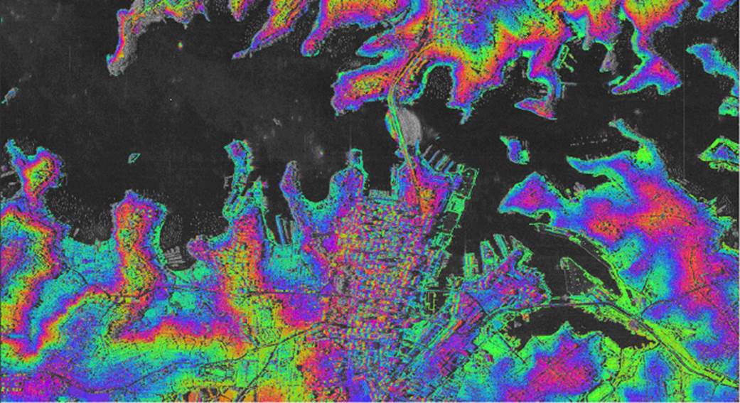
The SAR system operating at low frequency is susceptible to Radio Frequency Interference (RFI) from television station, radio station, and some other civil electronic facilities. The presence of RFI degrades the SAR image quality, and obscures the targets in the scene. Furthermore, RFI can cause interferometric phase error in repeat track InSAR system. In order to analyze the effect of RFI on interferometric phase of InSAR, real measured RFI signal are added on cone simulated SAR echoes. The imaging and interferometric processing results of both the RFI-contaminated and raw data are given. The effect of real measured RFI signal on repeat track InSAR system is analyzed. Finally, the imaging and interferometric processing results of both with and without RFI suppressed of the P band airborne repeat track InSAR real data are presented, which demonstrates the efficiency of the RFI suppression method in terms of decreasing the interferometric phase errors caused by RFI.
The SAR system operating at low frequency is susceptible to Radio Frequency Interference (RFI) from television station, radio station, and some other civil electronic facilities. The presence of RFI degrades the SAR image quality, and obscures the targets in the scene. Furthermore, RFI can cause interferometric phase error in repeat track InSAR system. In order to analyze the effect of RFI on interferometric phase of InSAR, real measured RFI signal are added on cone simulated SAR echoes. The imaging and interferometric processing results of both the RFI-contaminated and raw data are given. The effect of real measured RFI signal on repeat track InSAR system is analyzed. Finally, the imaging and interferometric processing results of both with and without RFI suppressed of the P band airborne repeat track InSAR real data are presented, which demonstrates the efficiency of the RFI suppression method in terms of decreasing the interferometric phase errors caused by RFI.
2012, 1(1): 91-95.
According to analysis of separating the mixed echo by suppressing the cross-correlation noise in dual-input and dual-output SAR system, a new method based on threshold filter and inverse filter was proposed. The method can eliminate the most energy of cross-correlation noise by threshold filter, which can suppress the cross-correlation noise well. The principle and implementation steps are presented in detail. The computer simulation and account for the integrated sidelobe ratio showed the effectiveness of the proposed method.
According to analysis of separating the mixed echo by suppressing the cross-correlation noise in dual-input and dual-output SAR system, a new method based on threshold filter and inverse filter was proposed. The method can eliminate the most energy of cross-correlation noise by threshold filter, which can suppress the cross-correlation noise well. The principle and implementation steps are presented in detail. The computer simulation and account for the integrated sidelobe ratio showed the effectiveness of the proposed method.
2012, 1(1): 96-99.
Accurate phase stability measurement of Transmitting and Receiving channels in space-borne SAR (Synthetic Aperture Radar) system is important to evaluate imaging quality. Based on fewer instruments, matched filtering and interpolation algorithm, two kinds of measure methods which makes the measurement value more accurate are presented and compared in this paper. The test result of one space-borne SAR prototyping system indicates that the methods are feasible and effective.
Accurate phase stability measurement of Transmitting and Receiving channels in space-borne SAR (Synthetic Aperture Radar) system is important to evaluate imaging quality. Based on fewer instruments, matched filtering and interpolation algorithm, two kinds of measure methods which makes the measurement value more accurate are presented and compared in this paper. The test result of one space-borne SAR prototyping system indicates that the methods are feasible and effective.
2012, 1(1): 100-108.
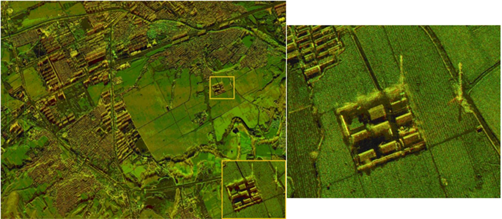
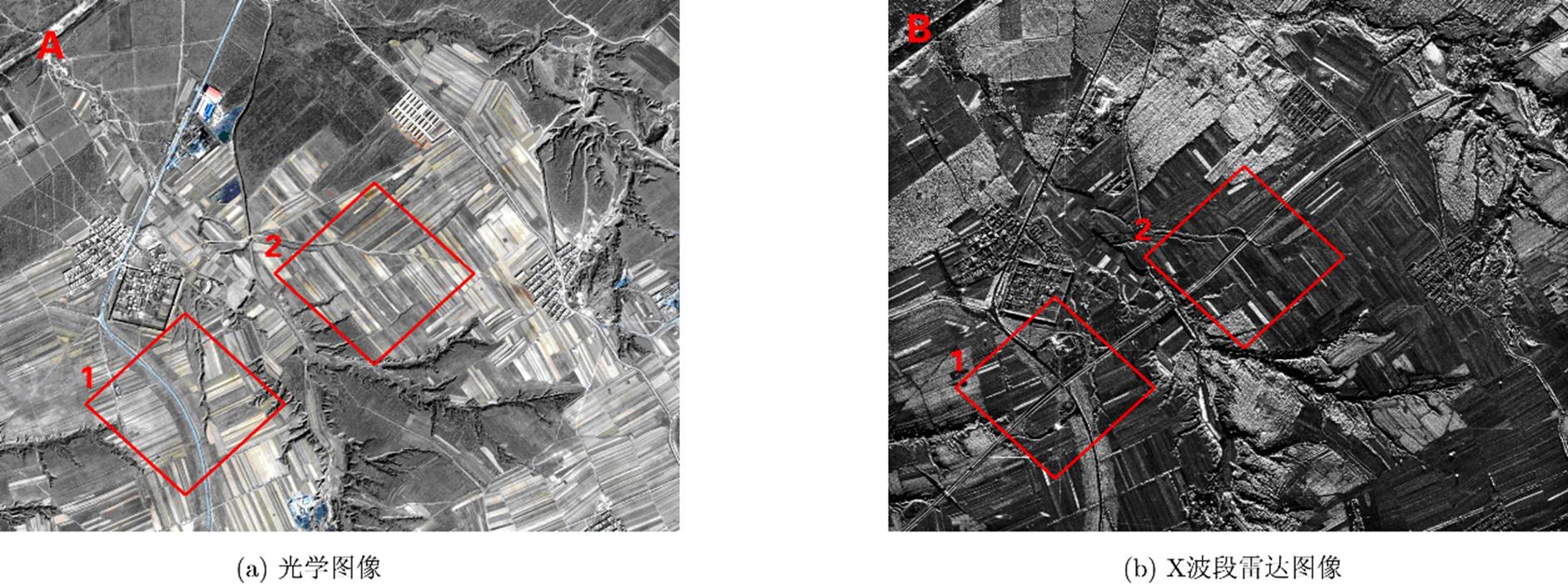
Road junctions are important parts of the road network, and have a major role in GIS database updating, image matching, object detecting, and so on. In high resolution SAR images, there exist various kinds of interference on the road, and the contrast is not obvious between roads and surroundings. It is difficult to extract road junctions by traditional methods. A new method is proposed for directly detecting and identifying road junctions in this paper. Firstly, based on the junctions gray feature, global searching is done for the center positions of the road junctions candidate regions, by using morphological transformation methods. Secondly, the center positions are set as the local windows centers, road targets are segmented by using the multi-threshold Otsu method in the local windows. Thirdly, according to the geometric characteristics of junctions, we obtain the angle-mean figure in the rectangular template rotation process, and then get the number of the roads connected to a junction. Finally, the style of the junction is recognized. In 1 m high-resolution airborne SAR image experiment, the results indicate that this method is effective to detect and identify the junctions with various interferences.
Road junctions are important parts of the road network, and have a major role in GIS database updating, image matching, object detecting, and so on. In high resolution SAR images, there exist various kinds of interference on the road, and the contrast is not obvious between roads and surroundings. It is difficult to extract road junctions by traditional methods. A new method is proposed for directly detecting and identifying road junctions in this paper. Firstly, based on the junctions gray feature, global searching is done for the center positions of the road junctions candidate regions, by using morphological transformation methods. Secondly, the center positions are set as the local windows centers, road targets are segmented by using the multi-threshold Otsu method in the local windows. Thirdly, according to the geometric characteristics of junctions, we obtain the angle-mean figure in the rectangular template rotation process, and then get the number of the roads connected to a junction. Finally, the style of the junction is recognized. In 1 m high-resolution airborne SAR image experiment, the results indicate that this method is effective to detect and identify the junctions with various interferences.

 微信 | 公众平台

