DatasetinthePaper 2025 No.2
Data Editors:xiang yu ming
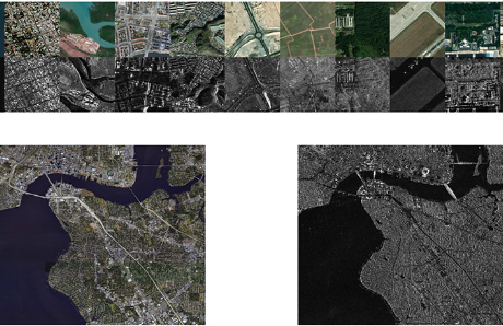
Dataset Introduction: OSDataset2.0, a large-scale benchmark dataset designed for optical-SAR image matching tasks. The dataset consists of two components: a local training dataset and a full-scene test set. The local training dataset provides 6,343 registered image patch pairs of 512×512 pixels (with a spatial resolution of 1 meter), covering nearly 20 countries worldwide. The dataset was generated through multi-method matching combined with manual verification. The full-scene test set includes a pair of full-scene optical and SAR images in GeoTIFF format, with a spatial resolution of 0.43 meters and data sizes of 35,783x35,783 and 35,507x27,298 pixels. The ground truth data was collected based on the consistency principle of imaging mechanisms for streetlight pole structures in both optical and SAR payloads, resulting in 72 high-precision ground truth corresponding point pairs. We also provide accompanying general evaluation code, supporting quantitative analysis of registration accuracy for any matching algorithm.

The data usage can be found in the paper:![]() OSDataset2.0: Optical-SAR Image Matching Dataset and Evaluation Benchmark.pdf
OSDataset2.0: Optical-SAR Image Matching Dataset and Evaluation Benchmark.pdf
Data release time:2025-10-31
References and Citation Format for This Dataset:
XIANG Yuming, CHEN Jinyang, HONG Zhonghua, et al. OSDataset2.0: SAR-optical image matching dataset and evaluation benchmark[J]. Journal of Radars, 2025, in press. doi: 10.12000/JR25176
Download
Register
Data Usage Protocol of Journal of Radars
The data can be used free of charge for scientific research, teaching and so on, but the data source should be marked in the reference according to the citation format.
Data use for commercial purposes requires permission from the Editorial Department of Journal of Radars.


 Submit Manuscript
 Peer Review
 Editor Work
 微信 | 公众平台

