基于极化联合特征的海面目标检测方法

陈世超 高鹤婷 罗丰

施天玥, 刘惠欣, 刘衍琦, 等. 基于先验相位结构信息的双基SAR两维自聚焦算法[J]. 雷达学报, 2020, 9(6): 1045–1055. doi: 10.12000/JR20048
引用本文: 陈世超, 高鹤婷, 罗丰. 基于极化联合特征的海面目标检测方法[J]. 雷达学报, 2020, 9(4): 664–673. doi: 10.12000/JR20072
SHI Tianyue, LIU Huixin, LIU Yanqi, et al. Bistatic synthetic aperture radar two-dimensional autofocus approach based on prior knowledge on phase structure[J]. Journal of Radars, 2020, 9(6): 1045–1055. doi: 10.12000/JR20048
Citation: CHEN Shichao, GAO Heting, and LUO Feng. Target detection in sea clutter based on combined characteristics of polarization[J]. Journal of Radars, 2020, 9(4): 664–673. doi: 10.12000/JR20072

基于极化联合特征的海面目标检测方法

DOI: 10.12000/JR20072
基金项目: 国家重大科学仪器设备开发专项资金(2013YQ20060705)
详细信息
    作者简介:

    陈世超(1992–),女,西安电子科技大学雷达信号处理国家重点实验室博士生,研究方向为海杂波建模与仿真、海杂波背景下的目标检测。E-mail: scchen0115@163.com

    高鹤婷(1981–),女,本科毕业于哈尔滨工业大学计算机应用科学与技术专业,现就职于中国人民解放军海军701工厂,研究方向为雷达算法研究。E-mail: gaoheting_810512@sina.com

    罗 丰(1971–),男,西安电子科技大学雷达信号处理国家重点实验室博士生导师,教授,研究方向为雷达系统设计、雷达信号与信息处理、高速实时信号处理。E-mail: luofeng@xidian.edu.cn

    通讯作者:

    罗丰 luofeng@xidian.edu.cn

  • 责任主编:刘宁波 Corresponding Editor: LIU Ningbo
  • 中图分类号: TN959.72

Target Detection in Sea Clutter Based on Combined Characteristics of Polarization

Funds: The National Key Scientific Instrument and Equipment Development Project Funds (2013YQ20060705)
More Information
  • 摘要: 该文从全极化体制角度出发,提出一种基于极化联合特征的海面目标检测方法。首先基于极化协方差矩阵,通过Cloude特征分解,提取表征回波随机程度的极化熵和反熵的数学期望;接着直接基于极化散射矩阵,通过Krogager特征分解,提取表征回波中极化散射分量结构组成的球散射体分量、二面角散射体分量和螺旋体散射分量的归一化系数;由提取的特征构成五维特征空间,利用主成分分析(PCA)降维证明所提特征具有良好的可分性,最后采用一类支持向量机(OCSVM)对目标和杂波进行识别。所提方法分别从极化相干和非相干分解两个角度出发,通过两种不同的极化分解方式提取特征,在一定程度上解决了高海情下基于单一极化分解方法存在的检测效果不理想的问题。通过IPIX实测数据验证所提方法具有良好的检测能力。


  • Today, the research and application of Artificial Intelligence (AI) has become a major area of scientific and technological development. Developing AI is a major strategy for enhancing national core competitiveness and maintaining national security.

    The Massachusetts Institute of Technology (MIT) has not established a new college for decades. However, in October 2018, MIT announced a new facility, the Schwarzman College of Computing[1], and the construction of the Stata Science Center (see Fig. 1) for computer science, AI, data science, and related intersections. Its purpose is to harness the powerful role of AI and big data computing in science and technology of the future. From Fig. 2, the SCR-615B radar built by MIT during World War II is on display in the Stata Science Center lobby. The MIT president also published an article in this year’s MIT newsletter[2] emphasizing the competition and challenges brought by AI.

    Figure  1.  MIT Stata Science Center
    Figure  2.  SCR-615B radar displayed in the hall

    In 2016, the United States (U.S.) White House released three important reports titled Preparing for the Future of Artificial Intelligence, National Artificial Intelligence Research and Development Strategic Plan, and Artificial Intelligence, and Automation and Economic Report, which promoted the establishment of a Machine Learning and Artificial Intelligence (MLAI) subcommittee that would actively plan for the future development of AI[3]. In January 2018, the United States Department of Defense released a new version of the National Defense Strategy report, stating that the development of advanced computing, big data analysis, and robotics are important factors affecting national security. In June 2018, the U.S. Defense Advanced Research Projects Agency (DARPA) discussed for the first time the preliminary details of the U.S. Electronic Revival Plan. The implementation of this Electronic Revival Plan will accelerate the development of AI hardware. In September of the same year, DARPA announced its commitment to building a system based on common sense, contextual awareness, and higher energy efficiency[4]. In February 2019, U.S. President Trump signed an executive order titled To Maintain U.S. Artificial Intelligence Leadership, which aims to maintain U.S. global leadership in AI. On February 12, 2019, the U.S. Department of Defense website published a Summary of the 2018 Department of Defense Artificial Intelligence Strategy—Harnessing AI to Advance Our Security and Prosperity, which clarified the U.S. military’s strategic initiatives and key areas for deploying AI[5]. The U.S. Department of Defense plans to use DARPA’s Next Generation Artificial Intelligence (AI Next) and Artificial Intelligence Exploration (AIE) projects as benchmarks for exploring and applying AI technologies to enhance military strength. The AI Next project, which was announced in September 2018, is based on the two generations of AI technology that were led by DARPA over the past 60 years. It emphasizes the environmentally adaptive capability of AI. The main areas of this project are to explore new technologies that promote the Department of Defense’s automation of key business processes, improve the robustness and reliability of AI systems, enhance the security and flexibility of machine learning and AI technologies, reduce power consumption and avoid inefficient data collection and performance, and create the next generation of AI algorithms and applications[6]. The AIE program will focus on Third Wave applications and theories of AI and aim to adapt machines to changing conditions. It will streamline proposals, contracts, and funding processes. The goal is to accelerate the research and development of AI platforms to help the U.S. maintain its technical advantages in the field of AI.

    In March 2017, France released its Artificial Intelligence Strategy, built a new AI center, and developed data storage and processing platforms, automatic learning technology platforms, and network security platforms[7]. The German Brain Science strategy focuses on robotics and digitization. In 2012, the Max Planck Institute for Scientific Research in Germany cooperated with the U.S. in computational neuroscience[8]. Japan also attaches great importance to the development of AI technology. In 2017, the Japanese government issued the Next Generation Artificial Intelligence Promotion Strategy to clarify its focus on AI development and to promote the extension of AI technology to strong AI and super AI levels[9].

    China released the New Generation Artificial Intelligence Development Plan in July 2017 and formulated a three-step goal for the national AI strategy. By 2030, China’s AI theory, technology, and applications will generally reach world-leading levels and become the world’s major AI innovation center[10]. Currently, China is showing very strong scientific research mobilization in the research and application of AI. For example, in August 2017, the National Natural Science Foundation of China (NSFC) released Guidelines for Emergency Management of Basic Research in Artificial Intelligence, which outlines plans to fund research in 25 research directions in three foundational aspects of the AI frontier, including intelligent autonomous movement bodies, intelligent decision-making theory, and key technologies of complex manufacturing processes[11]. We believe that, driven by innovation, China will achieve significant development in the research, application, and industrial fields of AI and AI technology, occupying an important territory in the world of AI.

    In this paper, we propose the development of AI technology in the field of space remote sensing and target recognition. In 2017, we hosted the Institute of Electrical and Electronics Engineers’ (IEEE) Remote Sensing Intelligent Processing Conference[12] and published some papers in the IEEE Transactions on Geoscience and Remote Sensing/Geoscience and Remote Sensing Letters[13-16]. We have also published several discussions in the Science & Technology Review [17,18], highlighting concepts regarding physical intelligence and microwave vision. Here we focus on Synthetic Aperture Radar (SAR) target monitoring and information perception and discuss the research on AI information technology against the physical background of the interaction between electromagnetic waves and targets, i.e., the use of this physical intelligence to develop microwave visions that can perceive target information on the electromagnetic spectrum that cannot be recognized by the human eye.

    In the 1950s, SAR images were only single-mode RCS grayscale images used for monitoring military targets. Later, in the 1970s, the development and application of this technology began to make great strides in civilian fields of study, such as ocean wind fields, terrestrial hydrology, vegetation, snow, precipitation, drought, the monitoring and evaluation of natural disasters, and the identification of surface changes, to name a few. Various applications have various needs, and the theoretical and technical issues associated with different scientific connotations have strongly promoted the comprehensive development of SAR technology. Since the beginning of the 21st century, SAR satellite technologies have developed rapidly, with the realization of full polarization, interference, and high- resolution to produce a multisource multimode full-polarization high-resolution SAR (hereinafter referred to as multimode SAR) information technology (see Fig. 3).

    Figure  3.  Overview of SAR development in various countries

    With the improvement in spatial resolution to meters and decimeters, the perception of multimode SAR remote sensing information has produced a field of science and technology that has great significance for civilian and national defense technology. SAR in the 21st century promotes the research and application of Automatic Target Recognition (ATR). Based on the presence or absence of a one-dimensional to a two-dimensional object map, three-dimensional object feature recognition is achieved, along with identification of multi-dimensional object morphology.

    However, SAR information perception and target feature inversion and reconstruction are not accomplished by human vision. The interaction between electromagnetic waves and complex targets and their image-scattering mechanisms provide the physical basis for SAR imaging. We have studied the theoretical parameter modeling, numerical simulation, and physical and numerical characteristics in the frequency, spatial, time, and polarization domains, and have developed polarized SAR parametric simulation software, techniques for scattering and imaging calculations, and target classification, recognition, and feature reconstruction[19].

    Multimode SAR remote sensing produces a many series of images with multiple temporal and physical characteristics and rich and multiple types of complex data. Driven by remote sensing big data, remote sensing application technology has progressed in a broad range of areas. However, most of these are limited to traditional data statistical analysis and image processing technologies, which cannot meet the needs of multimode SAR technology and applications. In particular, it is difficult to realize the automatic recognition of various types of targets in the sky, land, and sea, as well as the perception and inversion reconstruction of fine-scale multi-dimensional information.

    In recent years, AI technology has attracted considerable attention from science and industry. Based on the recognition of local structure-features-whole target in the eye-retina-brain V1–V4 area, a simple perception rule was established to obtain visual perception ability. Using the method of computational neuroscience and driven by the fitting of big data, multi-layer convolution networks are constructed from the local structure and feature-vector space for large overall network calculations to realize the ability to perceive internal information, which is the basic idea of AI and deep learning.

    Similarly, we must determine how to develop a new smart brain-like function suitable for the perception of SAR information from electromagnetic wave image scattering, which differs from computer vision processing that is usually based on optical vision. To do so, it is necessary to construct an intelligent information technology that can perceive SAR information from the microwave spectrum. We call this the electromagnetic AI–new scientific technology, i.e., from optical vision by the human brain to humanoid brain electromagnetic waves–microwave vision, which is driven by remote sensing big data under the guidance of the physics mechanism of multi-source multimode full-polarimetric high-resolution SAR.

    Fig. 4 and Fig. 5 illustrate the physical basis of multimode SAR as a forward problem of electromagnetic-wave-scattering modeling simulation and an inverse problem of multi-dimensional information inversion and reconstruction. AI deep learning based on a brain-like computing neural algorithm is driven by various types of big data constrained by the physical background of multimode SAR remote sensing for processing perceptions of AI information for application in various fields.

    Figure  4.  Research and application of multisource and multimode SAR remote sensing information perception for space-ground-sea targets
    Figure  5.  Physical intelligence to application of remotely sensed big data

    Based on the SAR image-scattering mechanism, we developed a brain-like intelligent function for processing this type of big data to perceive SAR information. This is like seeing microwaves, i.e., microwave vision. Eventually, this technology will be able to perform automatic interpretations online and produce easy-to-accept visual representations and visual semantics. Known as microwave consciousness, this technology plays an important role in the technical methods of visual semantics, reasoning, decision-making, interactive detection, identification, interference, confrontation, and the attack of SAR scattered radiation fields.

    In Fig. 6, we propose a combined forward and inverse theory for the creation of electromagnetic-wave-scattering and brain-like AI research to generate a new intelligent algorithm. This cross-discipline electromagnetic AI (EM AI) has important applications in Earth remote sensing, ATR, electronic countermeasures, and satellite navigation communications. Therefore, this proposal represents remote sensing-communication-navigation technology in electromagnetic space.

    Figure  6.  Artificial intelligence of space electromagnetics

    We have recently edited a book series titled Spaceborne Microwave Remote Sensing[20], whereby 14 monographs will be published by Science Press in the next two years, eight monographs of which deal with the acquisition of SAR information (Fig. 7). These include the monograph Intelligent Interpretation of Radar Image Information, written by our laboratory team[21]. Based on the background and research status of SAR image interpretation, this monograph summarizes our laboratory’s latest research progress using deep learning intelligent technology in SAR ATR and polarized SAR feature classification, and provides sample data and program code for relevant chapters.

    Figure  7.  Spaceborne microwave remote sensing research and application series

    Some of the research conducted at our laboratory on intelligent information perception can be summarized as follows:

    • We proposed an intelligent recognition algorithm for SAR targets[15]. The full convolutional network we proposed reduces the number of independent parameters by removing fully connected layers. It achieved a classification accuracy of 99% for a 10-class task when applied to the SAR target classification dataset MSTAR[22]. In addition, an end-to-end target detection–discrimination–recognition method for SAR images was implemented. Furthermore, we proposed a fast-detection algorithm for surface ship targets, established an SAR image ship target data set, and performed a ship target classification experiment based on transfer learning.

    • We proposed a deep-learning training network algorithm in a complex domain[16], whereby we can train a Convolutional Neural Network (CNN) of a polarized SAR surface classification with complex multi-dimensional images in a polarized coherence matrix. This algorithm achieved state-of-the-art accuracy of 95% for a 15-class task on the Flevoland benchmark dataset[22].

    • We proposed a CNN using few samples for target ATR, which has good network generalization ability. We also studied the target recognition and classification ability of CNN feature-vector distribution under the condition of no samples[14]. Zero-sample learning is important for SAR ATR because training samples are not always suitable for all targets and scenarios. In this paper, we proposed a new generation-based deep neural network framework, the key aspect of which is a generative deconvolutional neural network, called a generator that automatically constructs a continuous SAR target feature space composed of direction-invariant features and direction angles while learning the target hierarchical representation. This framework is then used as a reference for designing and initializing the interpreter CNN, which is antisymmetric to the generator network. The interpreter network is then trained to map any input SAR image to the target feature space.

    • We proposed a deep neural network structure for CNN processing to despeckle SAR-image noise[23]. This process uses a CNN to extract image features and reconstruct a discrete RCS Probability Density Function (PDF). The network is trained by a mixed loss function that measures the distance between the actual and estimated SAR image intensity PDFs, which is obtained by the convolution between the reconstructed RCS PDF and the prior speckled PDF. The network can be trained using either simulated or real SAR images. Experimental results on both simulated SAR images and real NASA/JPL AIRSAR images confirm the effectiveness of the proposed noise-despeckling deep neural network.

    • Lastly, we proposed a colorized CNN processing method from single-polarized SAR images to polarized SAR images for scene analysis and processing[24]. This paper proposed a deep neural network that converts a single-polarized SAR image into a fully polarized SAR image. This network has two parts, a feature extraction network and a feature translation network that is used to match spatial and polarized features. Using this method, the polarization covariance matrix of each pixel can be reconstructed. The resulting fully polarized SAR image is very close to the real fully polarized SAR image not only visually but also in real PolSAR applications.

    In addition, part of the work of our laboratory is to do the SAR-AI-ATR identification of—base on domestic and foreign SAR data including China’s GF-3 SAR data. do the SAR-AI-ATR identification of ground vehicles, airport aircraft, and sea surface ships. In addition, we proposed a CNN method for the inversion of forest tree heights by interferometric SAR, i.e., INSAR, and a method for constructing the reciprocal generation of optical images and microwave radar images by the contrast training of optical and microwave images. The above work can be found in related monographs[21].

    Data is not synonymous with information. Big data is just material and a driver, and different data have different scientific connotations. Therefore, the use of simple and direct statistics in the analysis of big data cannot realize the perception of connotative information, especially in the imaging of multi-dimensional vectorized complex data of multimode microwave SAR, which is difficult to intuitively perceive by the human eye. In this paper, we proposed the use of AI driven by big data under the guidance of physics to retrieve information and develop new AI models and algorithms to meet the needs of SAR remote sensing physics and applications. Interdisciplinary AI research is very important. The realization of new EM AI technology will drive the development of multiple industries and applications.

    At present, research on multimode remote sensing intelligent information and target recognition is still in the exploratory stage, and further research is needed to continue to develop new theories, methods, and applications of microwave vision.

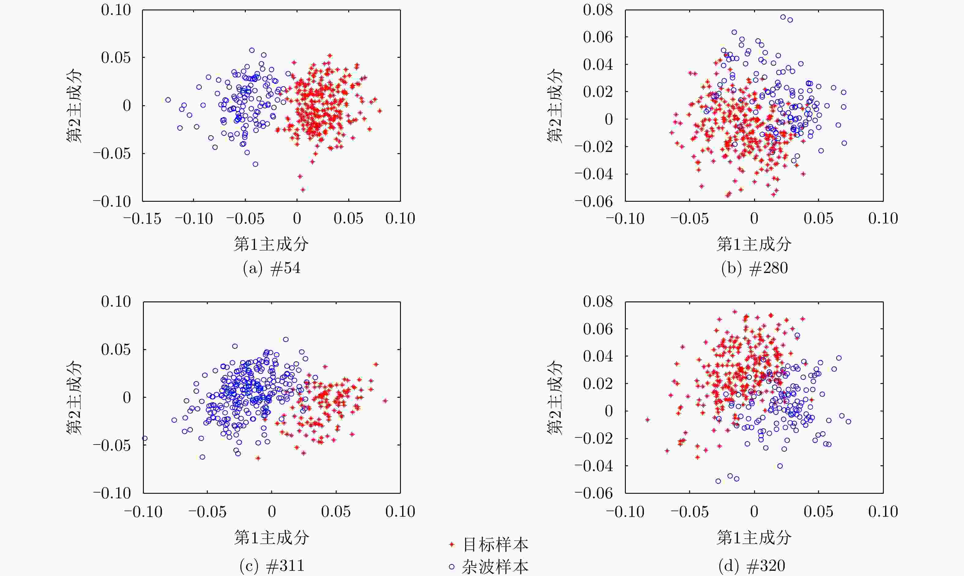
  • 图  1  各数据集第1杂波距离门与目标距离门特征对应的二维散布图

    Figure  1.  The 2D scatter graph corresponding to the characteristics of clutter cell and target cell in each dataset

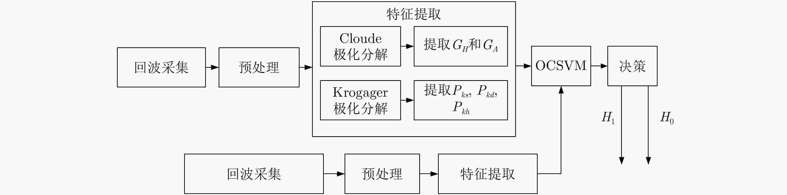
    图  2  基于极化联合特征的海面目标检测流程图

    Figure  2.  Flow chart of surface target detection based on polarization joint feature

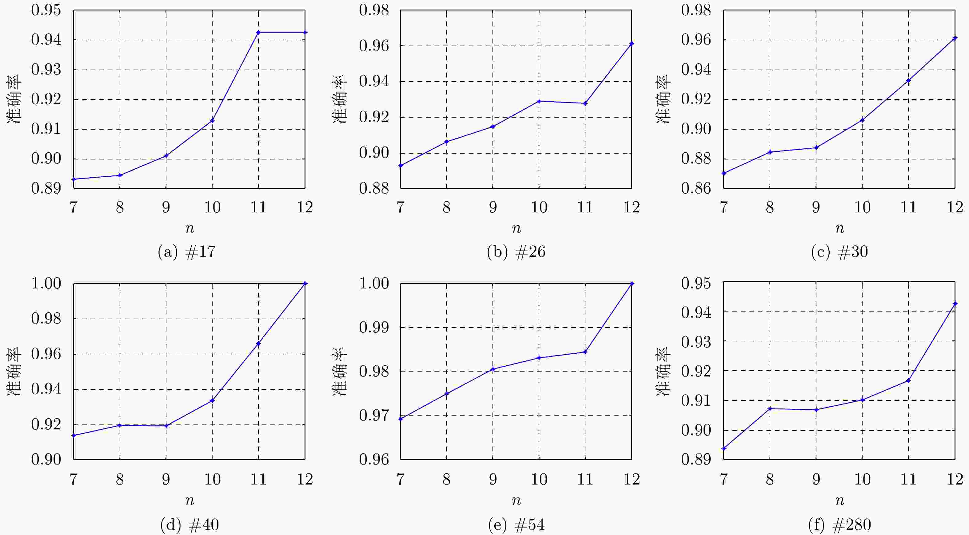
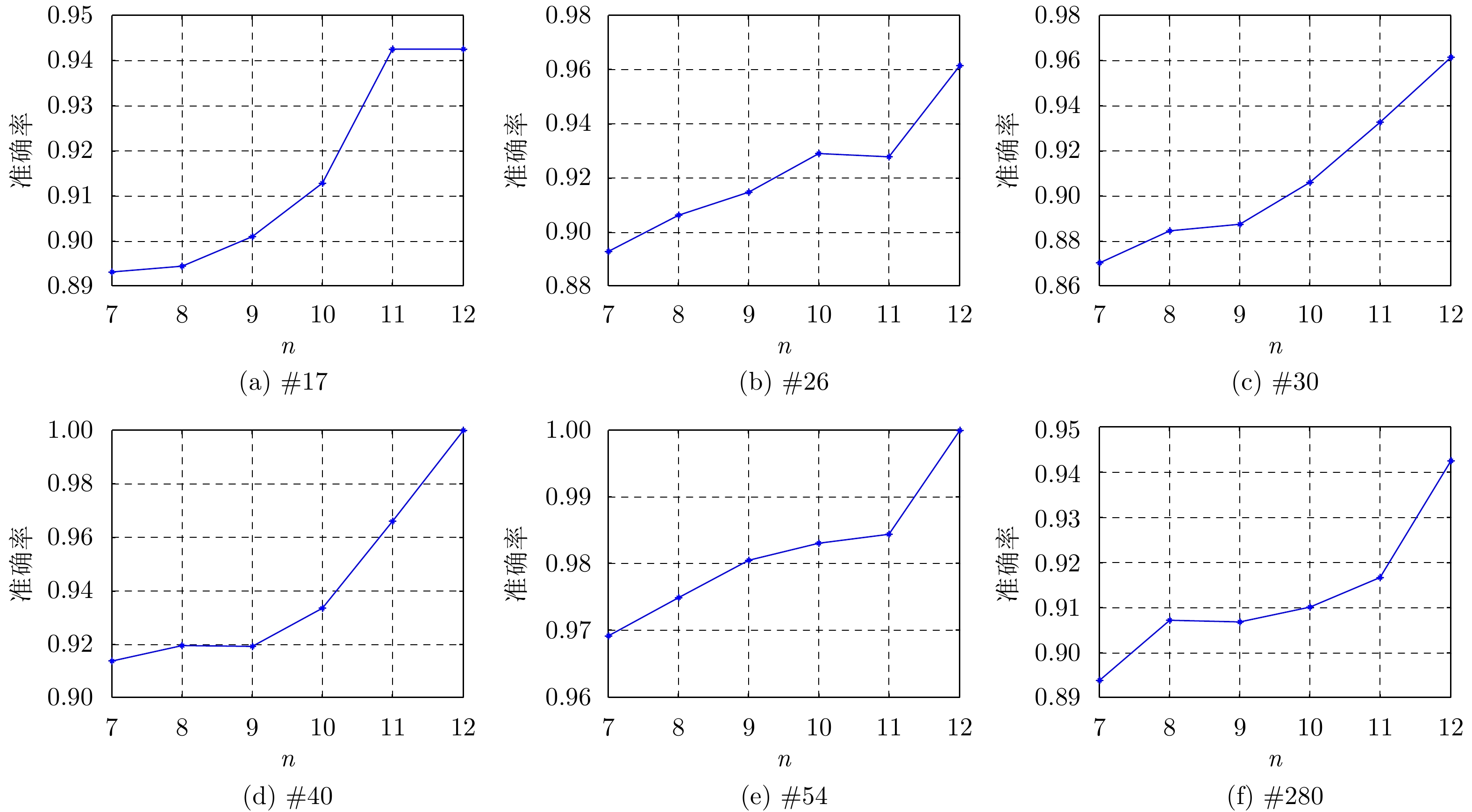
    图  3  不同观测时间下不同数据集的检测准确率

    Figure  3.  Detection accuracy of different data sets in different observation time

    表  1  1993年IPIX雷达数据主要参数说明

    Table  1.   The description of IPIX datasets in 1993

    序号数据编号目标所在单元受目标影响单元风速(km/h)浪高(m)平均信杂比(dB)
    1#1798:1192.211.95
    2#2676:891.16.43
    3#3076:8190.92.96
    4#3176:9190.98.03
    5#4075:891.011.39
    6#5487:10200.713.88
    7#28087:10101.66.20
    8#31076:9330.92.52
    9#31176:9330.911.38
    10#32076:9280.910.64
    下载: 导出CSV

    表  2  实验样本数说明

    Table  2.   The description of experimental sample number

    观测时间(ms)纯杂波样本数目标样本数训练样本数测试样本数
    纯杂波样本纯杂波样本目标样本数
    128102401024512051201024
    256512051225602560512
    512256025612801280256
    10241280128640640128
    20486406432032064
    40963203216016032
    下载: 导出CSV

    表  3  不同核函数下OCSVM在3组数据集上的检测正确率(%)

    Table  3.   The detection accuracy of OCSVM in the three datasets with different kernel functions

    核函数类型线性核函数多项式核函数Sigmoid核函数高斯核函数
    #5450.4991.9174.5196.81
    #28061.7672.7970.1089.07
    #31133.8286.2776.7295.10
    下载: 导出CSV

    表  4  不同极化分解后的检测性能

    Table  4.   The detection performance after different polarization decomposition

    数据编号特征向量目标检测概率(%)虚警概率(%)
    #280[GH,GA]65.6318.75
    [Ks,Kd,Kh]90.192.38
    [GH,GA,Ks,Kd,Kh]91.022.19
    #311[GH,GA]82.817.81
    [Ks,Kd,Kh]96.882.38
    [GH,GA,Ks,Kd,Kh]97.791.72
    #320[GH,GA]25.0018.74
    [Ks,Kd,Kh]95.941.56
    [GH,GA,Ks,Kd,Kh]98.571.25
    #54[GH,GA]86.884.69
    [Ks,Kd,Kh]95.942.38
    [GH,GA,Ks,Kd,Kh]98.311.88
    下载: 导出CSV

    表  5  不同观测时间下不同方法的检测性能

    Table  5.   The detection performance of different methods in different observation time

    观测时间(ms)CRFR
    DBEATri-FPC3D-PFM所提方法 DBEATri-FPC3D-PFM所提方法
    1280.84780.89610.89480.91260.01040.01040.01120.0126
    10240.85960.91780.91970.93770.01070.01460.01370.0166
    40960.87970.95100.94930.96680.01930.01750.02180.0181
    下载: 导出CSV
  • [1] FARINA A and STUDER F A. A review of CFAR detection techniques in radar systems[J]. Microware Journal, 1986, 29(5): 115, 116, 118.
    [2] 丁昊, 刘宁波, 董云龙, 等. 雷达海杂波测量试验回顾与展望[J]. 雷达学报, 2019, 8(3): 281–302. doi: 10.12000/JR19006

    DING Hao, LIU Ningbo, DONG Yunlong, et al. Overview and prospects of radar sea clutter measurement experiments[J]. Journal of Radars, 2019, 8(3): 281–302. doi: 10.12000/JR19006
    [3] 刘宁波, 董云龙, 王国庆, 等. X波段雷达对海探测试验与数据获取[J]. 雷达学报, 2019, 8(5): 656–667. doi: 10.12000/JR19089

    LIU Ningbo, DONG Yunlong, WANG Guoqing, et al. Sea-detecting X-band radar and data acquisition program[J]. Journal of Radars, 2019, 8(5): 656–667. doi: 10.12000/JR19089
    [4] 丁昊, 王国庆, 刘宁波, 等. 逆Gamma纹理背景下两类子空间目标的自适应检测方法[J]. 雷达学报, 2017, 6(3): 275–284. doi: 10.12000/JR16088

    DING Hao, WANG Guoqing, LIU Ningbo, et al. Adaptive detectors for two types of subspace targets in an inverse gamma textured background[J]. Journal of Radars, 2017, 6(3): 275–284. doi: 10.12000/JR16088
    [5] 许述文, 石星宇, 水鹏朗. 复合高斯杂波下抑制失配信号的自适应检测器[J]. 雷达学报, 2019, 8(3): 326–334. doi: 10.12000/JR19030

    XU Shuwen, SHI Xingyu, and SHUI Penglang. An adaptive detector with mismatched signals rejection in compound Gaussian clutter[J]. Journal of Radars, 2019, 8(3): 326–334. doi: 10.12000/JR19030
    [6] SHI Yanling, XIE Xiaoyan, and LI Dongchen. Range distributed floating target detection in sea clutter via feature-based detector[J]. IEEE Geoscience and Remote Sensing Letters, 2016, 13(12): 1847–1850. doi: 10.1109/LGRS.2016.2614750
    [7] 左磊, 产秀秀, 禄晓飞, 等. 基于空域联合时频分解的海面微弱目标检测方法[J]. 雷达学报, 2019, 8(3): 335–343. doi: 10.12000/JR19035

    ZUO Lei, CHAN Xiuxiu, LU Xiaofei, et al. A weak target detection method in sea clutter based on joint space-time-frequency decomposition[J]. Journal of Radars, 2019, 8(3): 335–343. doi: 10.12000/JR19035
    [8] LUO Feng, ZHANG Danting, and ZHANG Bo. The fractal properties of sea clutter and their applications in maritime target detection[J]. IEEE Geoscience and Remote Sensing Letters, 2013, 10(6): 1295–1299. doi: 10.1109/LGRS.2013.2237750
    [9] 陈世超, 罗丰, 胡冲, 等. 基于多普勒谱非广延熵的海面目标检测方法[J]. 雷达学报, 2019, 8(3): 344–354. doi: 10.12000/JR19012

    CHEN Shichao, LUO Feng, HU Chong, et al. Small target detection in sea clutter background based on Tsallis entropy of Doppler spectrum[J]. Journal of Radars, 2019, 8(3): 344–354. doi: 10.12000/JR19012
    [10] SHUI Penglang, LI Dongchen, and XU Shuwen. Tri-feature-based detection of floating small targets in sea clutter[J]. IEEE Transactions on Aerospace and Electronic Systems, 2014, 50(2): 1416–1430. doi: 10.1109/TAES.2014.120657
    [11] 许述文, 蒲佳. 基于四极化通道融合的海面漂浮微弱目标特征检测[J]. 信号处理, 2017, 33(3): 324–329. doi: 10.16798/j.issn.1003-0530.2017.03.011

    XU Shuwen and PU Jia. Floating small targets detection in sea clutter based on four-polarization-channels fusion[J]. Journal of Signal Processing, 2017, 33(3): 324–329. doi: 10.16798/j.issn.1003-0530.2017.03.011
    [12] 田玉芳, 尹志盈, 姬光荣, 等. 基于SVM的海面弱目标检测[J]. 中国海洋大学学报, 2013, 43(7): 104–109.

    TIAN Yufang, YIN Zhiying, JI Guangrong, et al. Weak targets detection in sea clutter based on SVM[J]. Periodical of Ocean University of China, 2013, 43(7): 104–109.
    [13] 武鹏, 王俊, 王文光. 基于极化特征分解的海上小目标检测算法研究[J]. 电子与信息学报, 2011, 33(4): 816–822. doi: 10.3724/SP.J.1146.2010.00678

    WU Peng, WANG Jun, and WANG Wenguang, et al. Small target detection in sea clutter based on polarization characteristics decomposition[J]. Journal of Electronics &Information Technology, 2011, 33(4): 816–822. doi: 10.3724/SP.J.1146.2010.00678
    [14] XU Shuwen, ZHENG Jibin, PU Jia, et al. Sea-surface floating small target detection based on polarization features[J]. IEEE Geoscience and Remote Sensing Letters, 2018, 15(10): 1505–1509. doi: 10.1109/LGRS.2018.2852560
    [15] MORRIS J T and ANDERSON S J. Aspect dependence of the polarimetric characteristics of sea clutter: I. Variation with elevation angle[C]. 2008 International Conference on Radar, Adelaide, Australia, 2008: 106–110.
    [16] ANDERSON S J and MORRIS J T. Aspect dependence of the polarimetric characteristics of sea clutter: II. Variation with azimuth angle[C]. 2008 International Conference on Radar, Adelaide, Australia, 2008: 581–585.
    [17] 张新勋, 周生华, 刘宏伟. 目标极化散射特性对极化分集雷达检测性能的影响[J]. 雷达学报, 2019, 8(4): 510–518. doi: 10.12000/JR18112

    ZHANG Xinxun, ZHOU Shenghua, and LIU Hongwei. Influence of target polarization scattering characteristics on the detection performance of polarization diversity radar[J]. Journal of Radars, 2019, 8(4): 510–518. doi: 10.12000/JR18112
    [18] AN Wentao, CUI Yi, and YANG Jian. Three-component model-based decomposition for polarimetric SAR data[J]. IEEE Transactions on Geoscience and Remote Sensing, 2010, 48(6): 2732–2739. doi: 10.1109/TGRS.2010.2041242
    [19] CLOUDE S R and POTTIER E. An entropy based classification scheme for land applications of polarimetric SAR[J]. IEEE Transactions on Geoscience and Remote Sensing, 1997, 35(1): 68–78. doi: 10.1109/36.551935
    [20] AN Wentao, CUI Yi, ZHANG Weijie, et al. Data compression for multilook polarimetric SAR Data[J]. IEEE Geoscience and Remote Sensing Letters, 2009, 6(3): 476–480. doi: 10.1109/LGRS.2009.2017498
    [21] KROGAGER E. New decomposition of the radar target scattering matrix[J]. Electronics Letters, 1990, 26(18): 1525–1527. doi: 10.1049/el:19900979
    [22] KROGAGER E, BOERNER W M, and MADSEN S N. Feature-motivated Sinclair matrix (sphere/diplane/helix) decomposition and its application to target sorting for land feature classification[C]. The SPIE 3120, Wideband Interferometric Sensing and Imaging Polarimetry, San Diego, USA, 1997. doi: 10.1117/12.300620.
    [23] CHAMUNDEESWARI V V, SINGH D, and SINGH K. An analysis of texture measures in PCA-based unsupervised classification of SAR images[J]. IEEE Geoscience and Remote Sensing Letters, 2009, 6(2): 214–218. doi: 10.1109/LGRS.2008.2009954
    [24] ZHANG Wei, DU Lan, LI Liling, et al. Infinite Bayesian one-class support vector machine based on Dirichlet process mixture clustering[J]. Pattern Recognition, 2018, 78: 56–78. doi: 10.1016/j.patcog.2018.01.006
    [25] XU Huan and HUANG Deshuang. One class support vector machines for distinguishing photographs and graphics[C]. IEEE International Conference on Networking, Sensing and Control, Sanya, China, 2008. doi: 10.1109/ICNSC.2008.4525289.
    [26] CHO H W. Data description and noise filtering based detection with its application and performance comparison[J]. Expert Systems with Applications, 2009, 36(1): 434–441. doi: 10.1016/j.eswa.2007.09.053
    [27] TIAN Jiang, GU Hong, GAO Chiyang, et al. Local density one-class support vector machines for anomaly detection[J]. Nonlinear Dynamics, 2011, 64(1/2): 127–130. doi: 10.1007/s11071-010-9851-y
    [28] BOUNSIAR A and MADDEN M G. Kernels for one-class support vector machines[C]. 2014 International Conference on Information Science & Applications (ICISA), Seoul, Republic of Korea, 2014. doi: 10.1109/ICISA.2014.6847419.
  • 加载中
图(3) / 表(5)
计量
  • 文章访问数: 2490
  • HTML全文浏览量: 1049
  • PDF下载量: 320
  • 被引次数: 0
出版历程
  • 收稿日期:  2020-05-30
  • 修回日期:  2020-07-30
  • 网络出版日期:  2020-08-28

目录

/

返回文章
返回