
 作者中心
作者中心 专家审稿
专家审稿 责编办公
责编办公 编辑办公
编辑办公
Demonstration of Spaceborne Multi-static SAR Tomography and Forest Height Estimation
-
摘要: 层析SAR (TomoSAR)技术凭借其三维分辨能力,能够对森林、冰川和积雪等场景的三维结构进行研究。但目前的星载层析SAR主要依靠重复轨道观测来实现。重轨层析SAR观测体制带来两大难题,一是时间去相干,二是对流层或电离层等导致的信号传播延时。严重的时间去相干和对流层、电离层传播延迟会使得层析成像出现散焦,导致无法进行场景三维结构重建。与重轨观测层析SAR体制不同,多站层析SAR所有图像在同一时刻获得,不存在时间去相干,信号传播延迟也能完全抵消,这使得多站层析SAR用于三维重建优势明显。航天宏图信息技术股份有限公司在2023年发射了世界首个X波段四星多站体制雷达星座—宏图一号,该文利用宏图一号星座的四星雷达数据,开展了星载多站层析SAR森林高度反演数据实验。通过对热带雨林和温带森林开展实验,发现宏图一号X波段雷达信号基本无法穿透茂密的热带雨林到达地面,但是能够穿透植被密度较小的温带森林,这表明宏图一号具备对温带森林进行森林高度反演的潜力。通过TomoSAR对温带森林进行树高反演,并以高精度机载激光雷达测得的树高为参考,与GEDI星载激光雷达测量结果做对比验证,发现在该文所采用的测试场景中,星载多站TomoSAR的测量结果比GEDI星载激光雷达具有更高的精度(提升约35%),更多的测量点数和更高的空间分辨率,验证了使用宏图一号数据进行层析SAR森林高度反演的可行性和优势。Abstract: Synthetic Aperture Radar Tomography (TomoSAR), by virtue of its three-dimensional (3D) resolution capability, can be used to study the 3D structure of semitransparent targets, such as forests, icebergs, and snowpacks. Currently, TomoSAR measurements, especially spaceborne TomoSAR, are mostly obtained through repeat-pass observations, which introduce two major problems: Temporal decorrelation and signal delay caused by the troposphere or ionosphere. Severe temporal decorrelation and signal delay can lead to defocused tomograms, which make it impossible to reconstruct the 3D structure of a target. Unlike repeat-pass TomoSAR systems, multi-static TomoSAR systems simultaneously collect multibaseline images, reducing temporal decorrelation to zero and canceling all types of signal delay, making them an ideal tool for 3D TomoSAR reconstruction. The Hongtu-1 constellation, launched in 2023 and operated by PIESAT Information Technology Limited, is the world’s first spaceborne multi-static SAR system. In this paper, we conduct spaceborne multi-static TomoSAR processing and forest height estimation experiments using Hongtu-1 multi-static images. By comparing tomograms from tropical and temperate forests, it is found that the X-band signal from Hongtu-1 cannot reach the ground in dense tropical forests, but can in temperate forests, due to much lower tree and leaf density. This indicates that Hongtu-1 is capable of forest height measurement in temperate forests. By comparing forest height inversion in temperate forests obtained from Hongtu-1 TomoSAR and GEDI LiDAR, it is found that, at the test sites considered in this paper, Hongtu-1 TomoSAR measurements can provide more accurate forest height inversion (with a 35% improvement), more measurement points, and higher-resolution products than GEDI, which further demonstrates the capability and superiority of Hongtu-1 TomoSAR in forest height estimation.
-
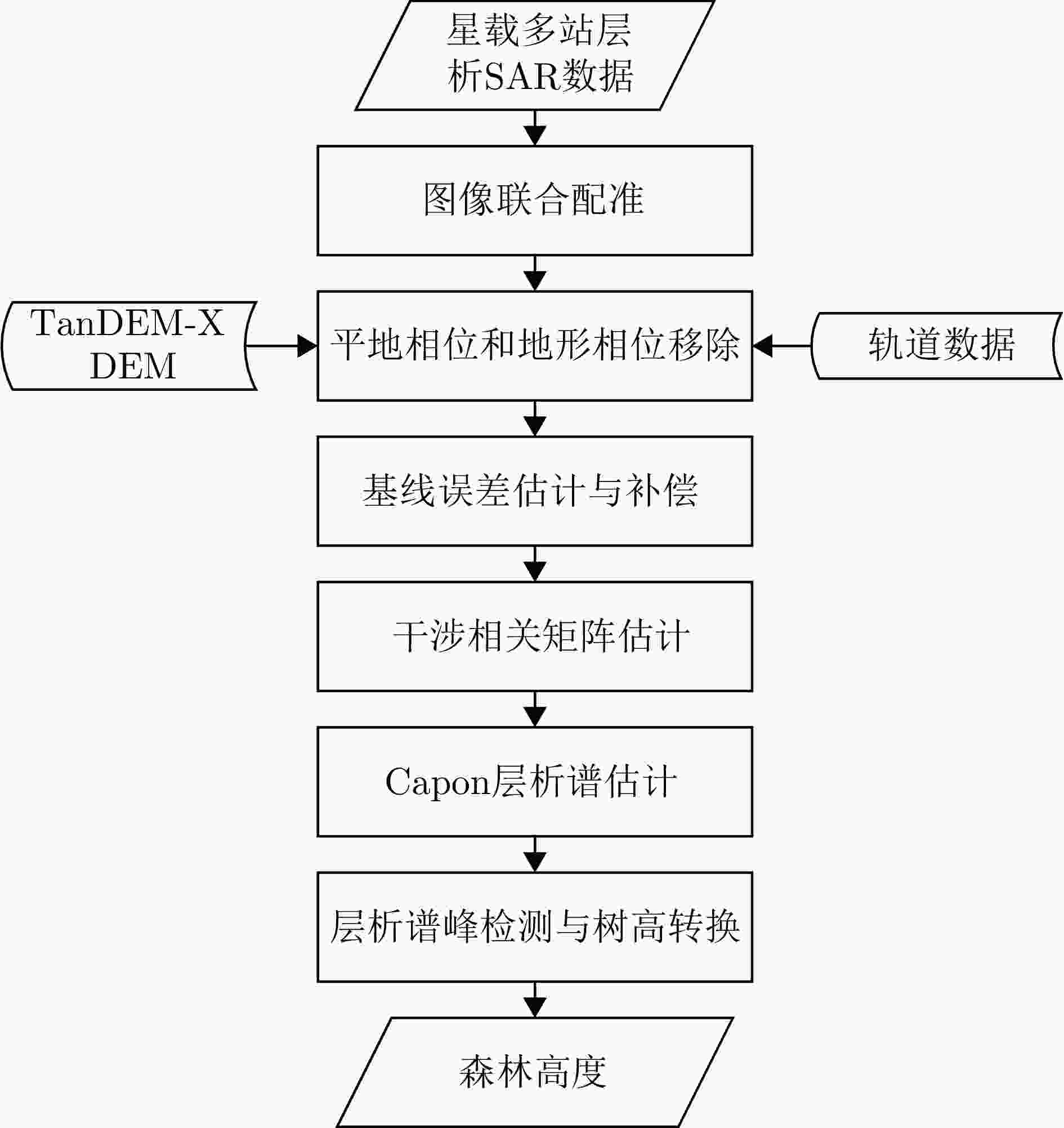
图 1 星载多站层析SAR处理与森林高度反演流程
Figure 1. Flowchart of spaceborne multi-static SAR tomography and forest height estimation
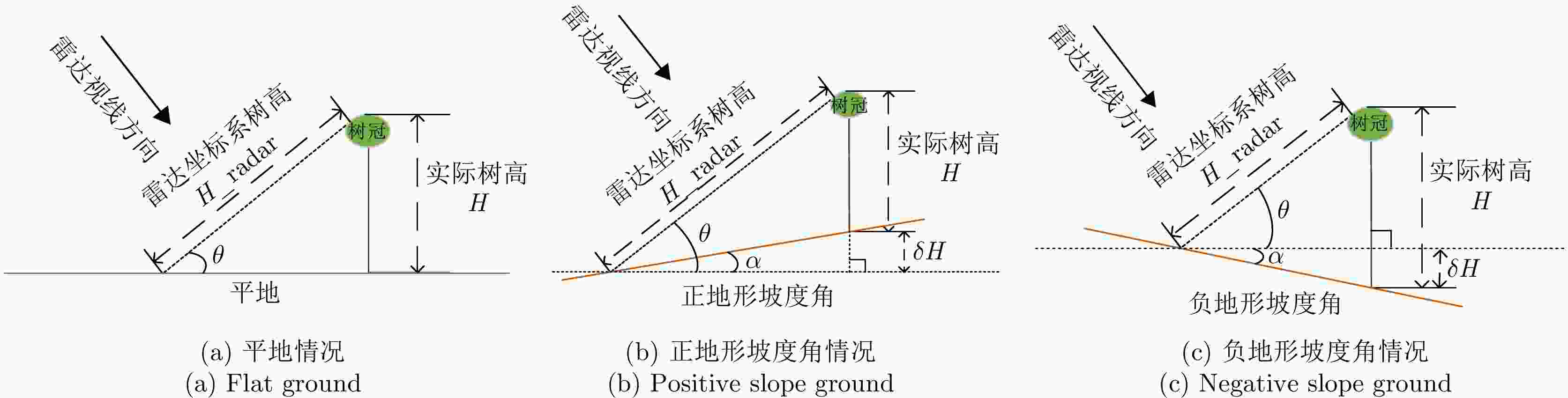
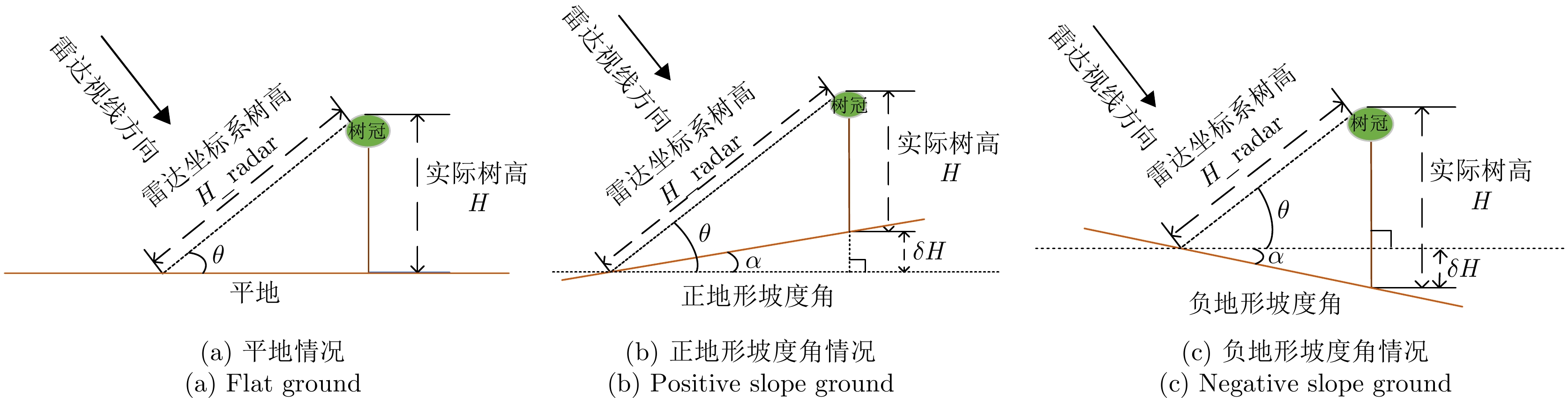
图 2 平地和正负地形坡度角情况下雷达坐标系树高和实际树高的转换关系示意图
Figure 2. Transformations between tree height in radar coordinates and actual tree height in geographic coordinates
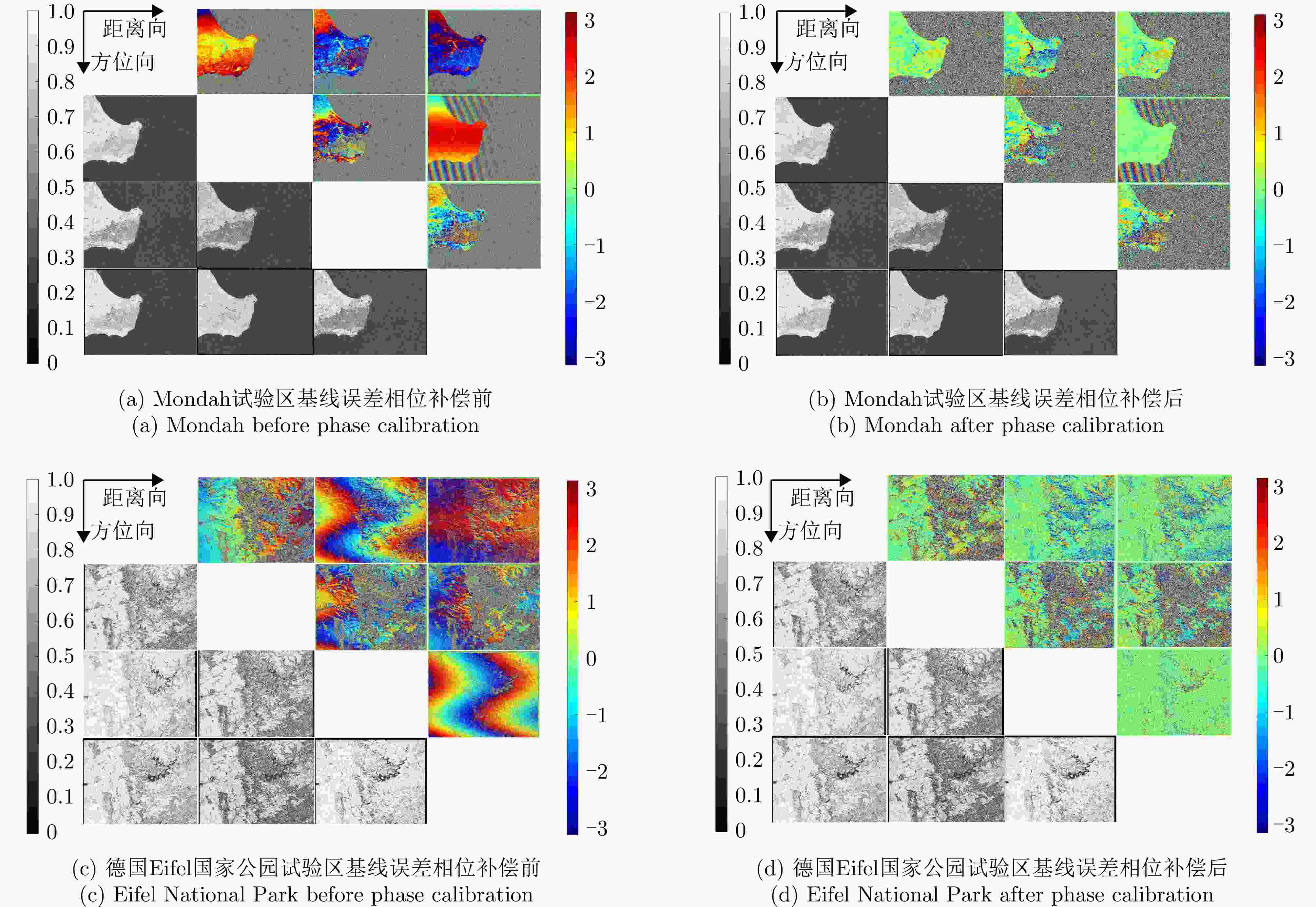
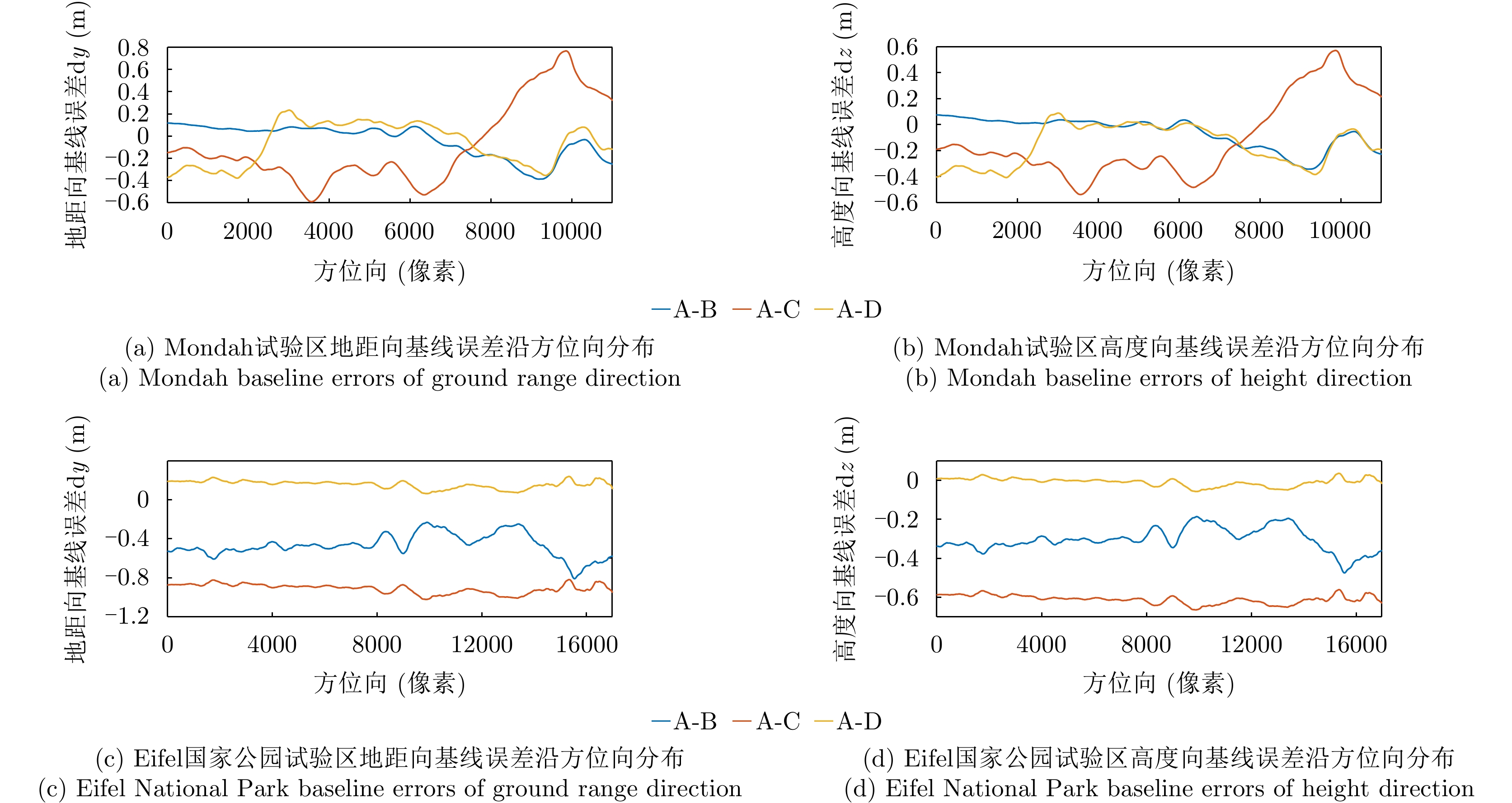
图 8 基线误差相位补偿前后两个试验区的干涉相位和相干系数
Figure 8. Interferogram and coherence of the two test sites before and after phase calibration
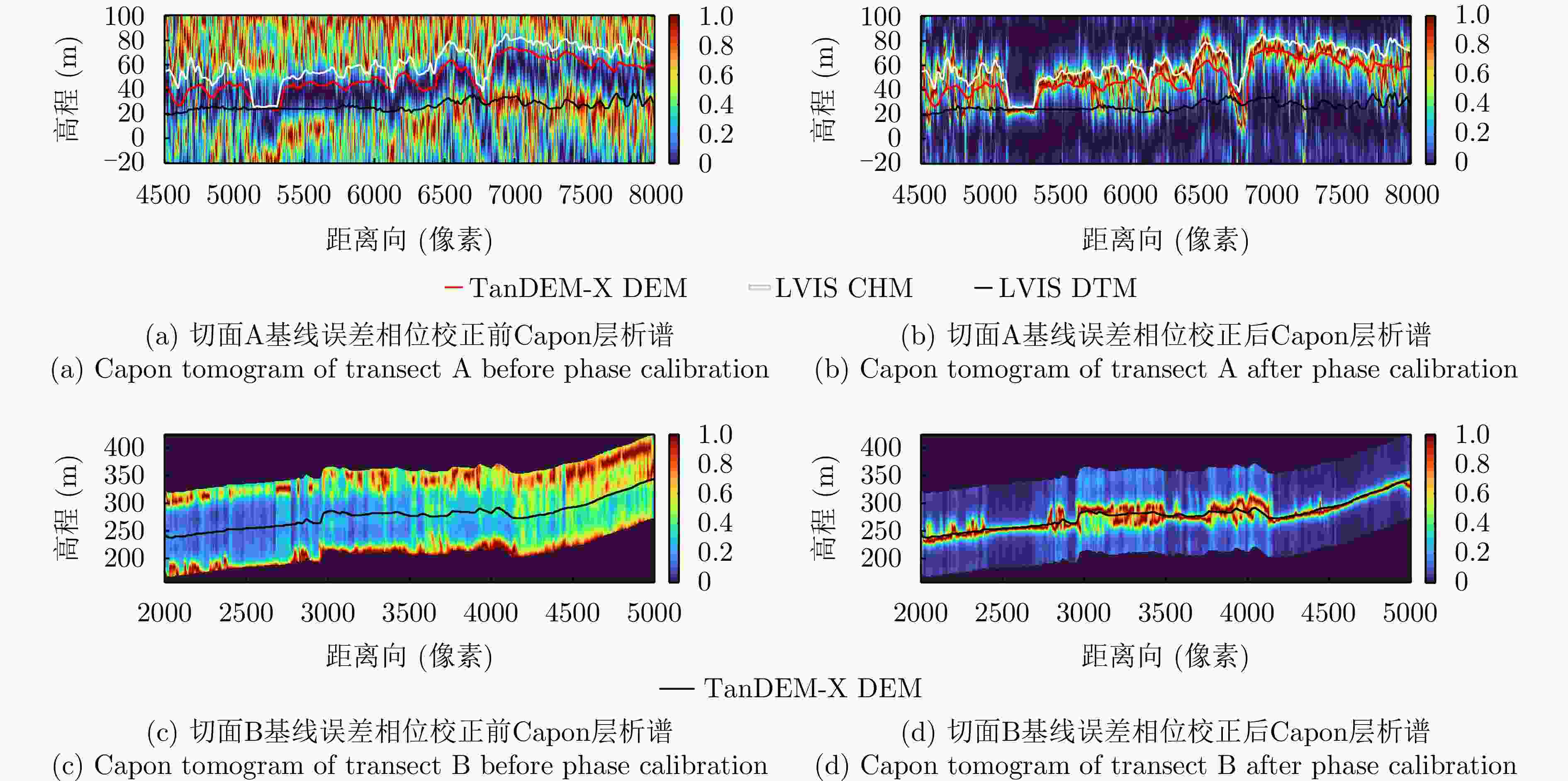
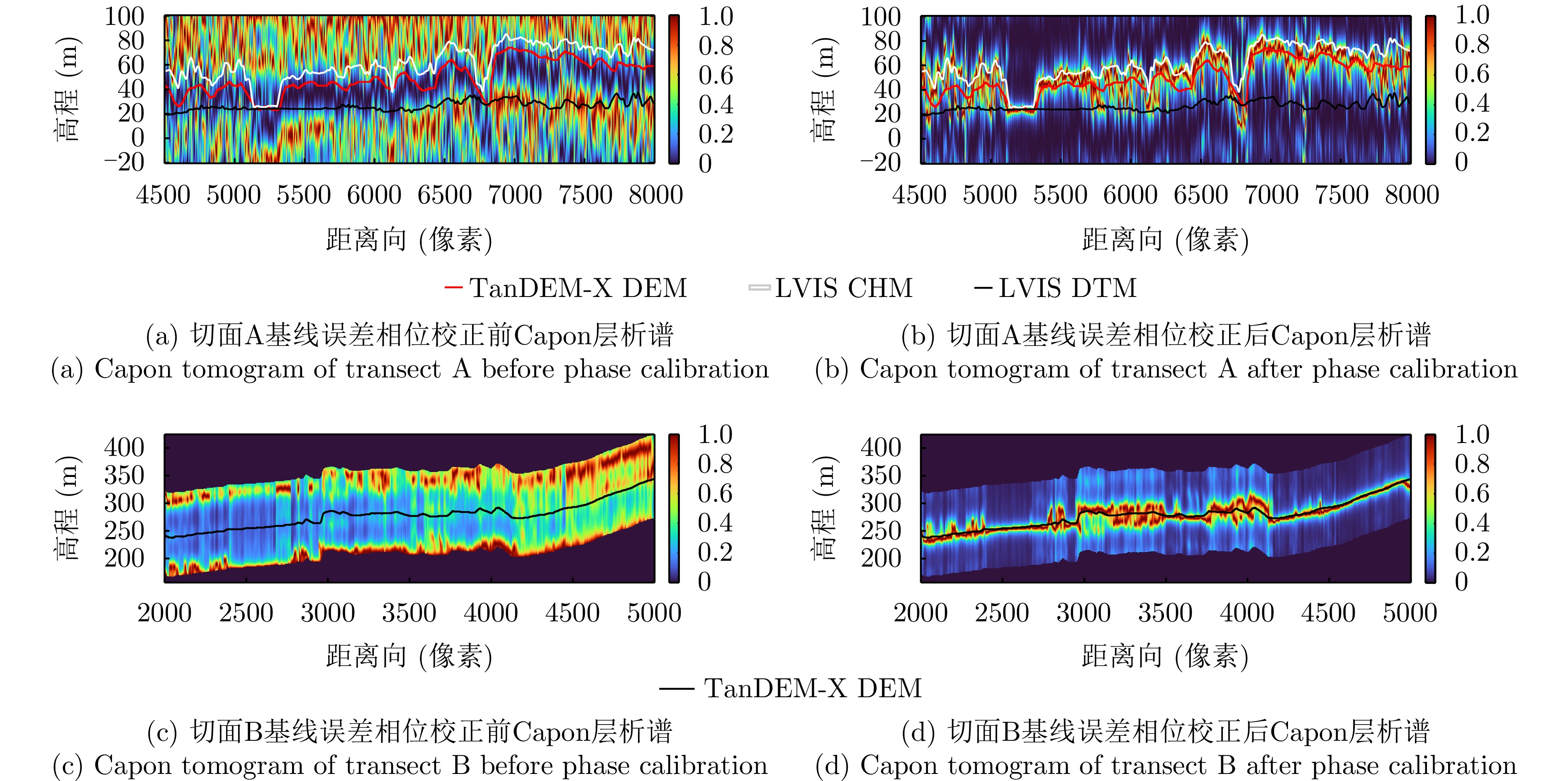
图 9 切面A和切面B基线误差相位校正前后层析谱
Figure 9. Tomograms of transect A and transect B before and after phase calibration
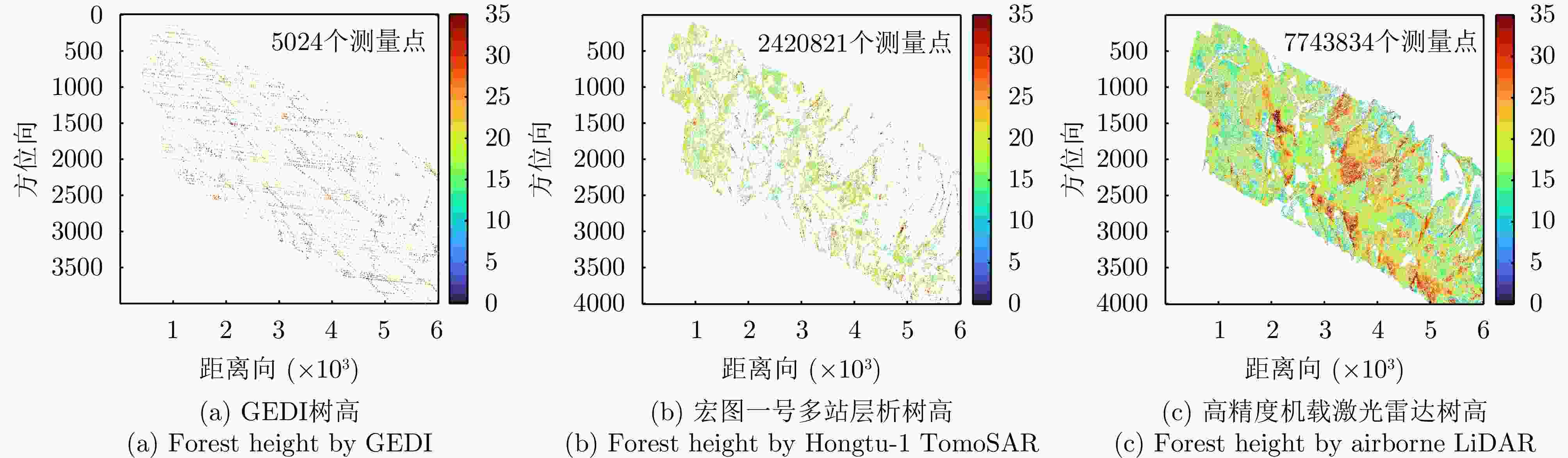
图 10 Eifel国家公园试验区区域C内的GEDI星载激光雷达、宏图一号多站层析和高精度机载激光雷达的树高测量结果
Figure 10. Forest height of area C in Eifel National Park test site by GEDI, Hongtu-1 TomoSAR and airborne LiDAR measurement
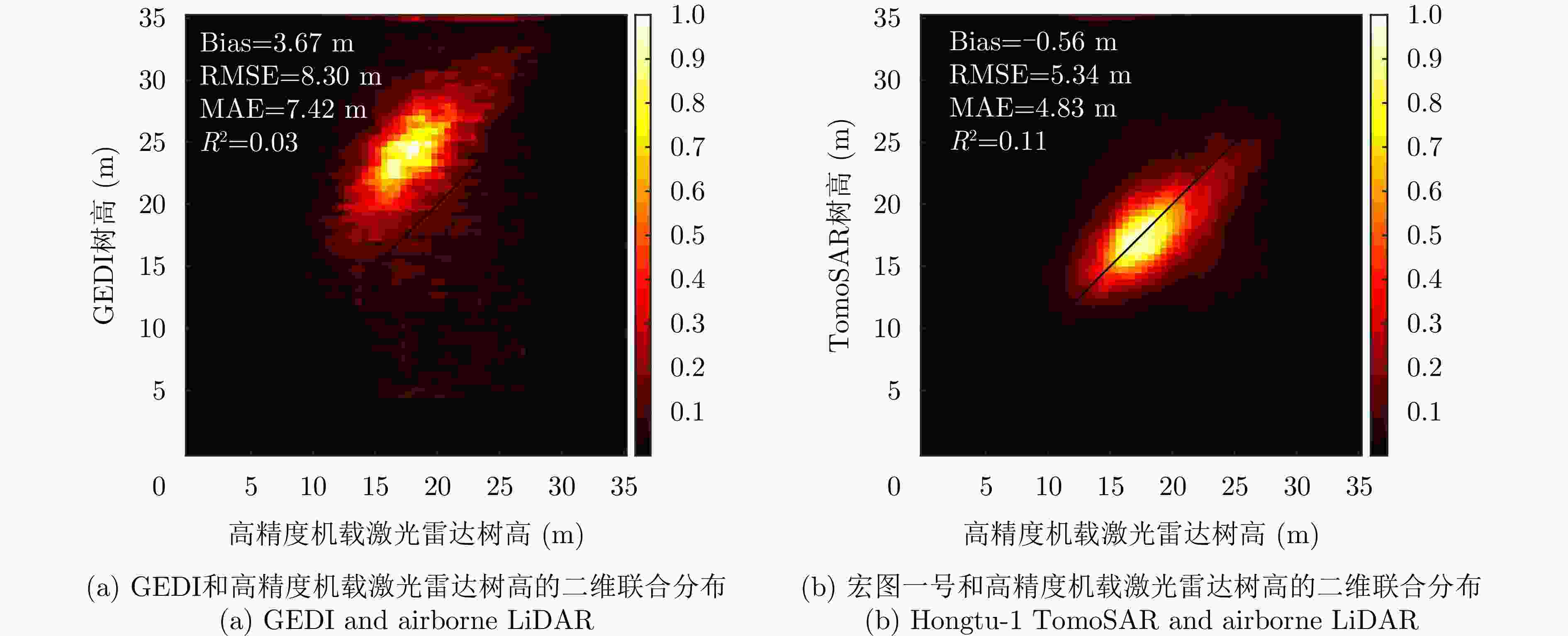
图 11 GEDI和宏图一号反演树高与高精度机载激光雷达树高的二维联合分布
Figure 11. 2D joint distribution between GEDI, Hongtu-1 TomoSAR and airborne LiDAR
表 1 宏图一号多站SAR系统详细参数
Table 1. Detailed parameters of Hongtu-1 multi-static SAR system
参数 指标 雷达信号发射星 A星 雷达信号接收星 A/B/C/D星 极化方式 HH 观测视向 左视 雷达中心频率 9.6 GHz 距离向带宽 100 MHz 脉冲重复频率 4201 Hz 距离向采样间隔 0.75 m 距离向分辨率 1.1 m 方位向采样间隔 1.3 m 方位向分辨率 2.8 m 轨道高度 528 km 重访周期 10 d 工作模式 条带模式 距离向幅宽 25 km 下视角 17°~50° Mondah中心斜距 702.5 km Eifel中心斜距 601.4 km  下载: 导出CSV
-
[1] PAN Yude, BIRDSEY R A, FANG Jingyun, et al. A large and persistent carbon sink in the world’s forests[J]. Science, 2011, 333(6045): 988–993. doi: 10.1126/science.1201609. [2] PAN Yude, BIRDSEY R A, PHILLIPS O L, et al. The enduring world forest carbon sink[J]. Nature, 2024, 631(8021): 563–569. doi: 10.1038/s41586-024-07602-x. [3] DUBAYAH R, ARMSTON J, HEALEY S P, et al. GEDI launches a new era of biomass inference from space[J]. Environmental Research Letters, 2022, 17(9): 095001. doi: 10.1088/1748-9326/ac8694. [4] DUNCANSON L, KELLNER J R, ARMSTON J, et al. Aboveground biomass density models for NASA’s Global Ecosystem Dynamics Investigation (GEDI) Lidar mission[J]. Remote Sensing of Environment, 2022, 270: 112845. doi: 10.1016/j.rse.2021.112845. [5] SCHUTZ B E, ZWALLY H J, SHUMAN C A, et al. Overview of the ICESat mission[J]. Geophysical Research Letters, 2005, 32(21): L21S01. doi: 10.1029/2005GL024009. [6] ABDALATI W, ZWALLY H J, BINDSCHADLER R, et al. The ICESat-2 laser altimetry mission[J]. Proceedings of the IEEE, 2010, 98(5): 735–751. doi: 10.1109/JPROC.2009.2034765. [7] 李震, 张平, 乔海伟, 等. 层析SAR地表参数信息提取研究进展[J]. 雷达学报, 2021, 10(1): 116–130. doi: 10.12000/JR20095.LI Zhen, ZHANG Ping, QIAO Haiwei, et al. Advances in information extraction of surface parameters using Tomographic SAR[J]. Journal of Radars, 2021, 10(1): 116–130. doi: 10.12000/JR20095. [8] 丁赤飚, 仇晓兰, 徐丰, 等. 合成孔径雷达三维成像—从层析、阵列到微波视觉[J]. 雷达学报, 2019, 8(6): 693–709. doi: 10.12000/JR19090.DING Chibiao, QIU Xiaolan, XU Feng, et al. Synthetic aperture radar three-dimensional imaging—from TomoSAR and array InSAR to microwave vision[J]. Journal of Radars, 2019, 8(6): 693–709. doi: 10.12000/JR19090. [9] LE TOAN T, QUEGAN S, DAVIDSON M W J, et al. The BIOMASS mission: Mapping global forest biomass to better understand the terrestrial carbon cycle[J]. Remote Sensing of Environment, 2011, 115(11): 2850–2860. doi: 10.1016/j.rse.2011.03.020. [10] QUEGAN S, LE TOAN T, CHAVE J, et al. The European Space Agency BIOMASS mission: Measuring forest above-ground biomass from space[J]. Remote Sensing of Environment, 2019, 227: 44–60. doi: 10.1016/j.rse.2019.03.032. [11] HAJNSEK I, SCHEIBER R, KELLER M, et al. BIOSAR 2008: Final report[R]. 22052/08/NL/CT-002, 2009. [12] DUBOIS-FERNANDEZ P C, LE TOAN T, DANIEL S, et al. The TropiSAR airborne campaign in French Guiana: Objectives, description, and observed temporal behavior of the backscatter signal[J]. IEEE Transactions on Geoscience and Remote Sensing, 2012, 50(8): 3228–3241. doi: 10.1109/TGRS.2011.2180728. [13] HAJNSEK I, PARDINI M, HORN R, et al. SAR imaging of tropical African forests with P-band multibaseline acquisitions: Results from the AfriSAR campaign[C]. 2016 IEEE International Geoscience and Remote Sensing Symposium (IGARSS), Beijing, China, 2016: 7521–7523. doi: 10.1109/IGARSS.2016.7730961. [14] HAJNSEK I, PARDINI M, GULIAEV R, et al. Mapping tropical forest in Gabon with L-/P-band multibaseline acquisitions: First results from the GabonX campaign[C]. ESA POLinSAR Workshop, Toulouse, France, 2023. [15] KHATI U, LAVALLE M, and SINGH G. Spaceborne tomography of multi-species Indian tropical forests[J]. Remote Sensing of Environment, 2019, 229: 193–212. doi: 10.1016/j.rse.2019.04.017. [16] AGHABABAEE H, FORNARO G, and SCHIRINZI G. Phase calibration based on phase derivative constrained optimization in multibaseline SAR tomography[J]. IEEE Transactions on Geoscience and Remote Sensing, 2018, 56(11): 6779–6791. doi: 10.1109/TGRS.2018.2843447. [17] BRCIC R, PARIZZI A, EINEDER M, et al. Estimation and compensation of ionospheric delay for SAR interferometry[C]. 2010 IEEE International Geoscience and Remote Sensing Symposium, Honolulu, USA, 2010: 2908–2911. doi: 10.1109/IGARSS.2010.5652231. [18] MEYER F J. Performance requirements for ionospheric correction of low-frequency SAR data[J]. IEEE Transactions on Geoscience and Remote Sensing, 2011, 49(10): 3694–3702. doi: 10.1109/TGRS.2011.2146786. [19] KRIEGER G. MIMO-SAR: Opportunities and pitfalls[J]. IEEE Transactions on Geoscience and Remote Sensing, 2014, 52(5): 2628–2645. doi: 10.1109/TGRS.2013.2263934. [20] TEBALDINI S, MANZONI M, FERRO-FAMIL L, et al. FDM MIMO spaceborne SAR tomography by minimum redundancy wavenumber illumination[J]. IEEE Transactions on Geoscience and Remote Sensing, 2024, 62: 5207119. doi: 10.1109/TGRS.2024.3371267. [21] MITTERMAYER J, KRIEGER G, BOJARSKI A, et al. MirrorSAR: An HRWS add-on for single-pass multi-baseline SAR interferometry[J]. IEEE Transactions on Geoscience and Remote Sensing, 2022, 60: 5224018. doi: 10.1109/TGRS.2021.3132384. [22] LÓPEZ-DEKKER P, BIGGS J, CHAPRON B, et al. The Harmony mission: End of phase-0 science overview[C]. 2021 IEEE International Geoscience and Remote Sensing Symposium IGARSS, Brussels, Belgium, 2021: 7752–7755. doi: 10.1109/IGARSS47720.2021.9554896. [23] DENG Yunkai, ZHANG Heng, LIU Kaiyu, et al. Hongtu-1: The first spaceborne single-pass multibaseline SAR interferometry mission[J]. IEEE Transactions on Geoscience and Remote Sensing, 2025, 63: 5202518. doi: 10.1109/TGRS.2024.3523299. [24] ZENG Guobing, XU Huaping, WANG Yuan, et al. A novel method for airborne SAR tomography baseline error correction driven by small baseline interferometric phase[J]. IEEE Transactions on Geoscience and Remote Sensing, 2024, 62: 5225013. doi: 10.1109/TGRS.2024.3478055. [25] REIGBER A and MOREIRA A. First demonstration of airborne SAR tomography using multibaseline L-band data[J]. IEEE Transactions on Geoscience and Remote Sensing, 2000, 38(5): 2142–2152. doi: 10.1109/36.868873. [26] FORNARO G, LOMBARDINI F, and SERAFINO F. Three-dimensional multipass SAR focusing: Experiments with long-term spaceborne data[J]. IEEE Transactions on Geoscience and Remote Sensing, 2005, 43(4): 702–714. doi: 10.1109/TGRS.2005.843567. [27] PARDINI M, PAPATHANASSIOU K, BIANCO V, et al. Phase calibration of multibaseline SAR data based on a minimum entropy criterion[C]. 2012 IEEE International Geoscience and Remote Sensing Symposium, Munich, Germany, 2012: 5198–5201. doi: 10.1109/IGARSS.2012.6352438. [28] TEBALDINI S, ROCCA F, D'ALESSANDRO M M, et al. Phase calibration of airborne tomographic SAR data via phase center double localization[J]. IEEE Transactions on Geoscience and Remote Sensing, 2016, 54(3): 1775–1792. doi: 10.1109/TGRS.2015.2488358. [29] KUGLER F, LEE S K, HAJNSEK I, et al. Forest height estimation by means of Pol-InSAR data inversion: The role of the vertical wavenumber[J]. IEEE Transactions on Geoscience and Remote Sensing, 2015, 53(10): 5294–5311. doi: 10.1109/TGRS.2015.2420996. [30] ZENG Guobing, XU Huaping, WANG Yuan, et al. Separation of ground and volume scattering in multibaseline polarimetric SAR data and its application in DTM and CHM inversion[J]. IEEE Transactions on Geoscience and Remote Sensing, 2024, 62: 5218119. doi: 10.1109/TGRS.2024.3430382. [31] GINI F, LOMBARDINI F, and MONTANARI M. Layover solution in multibaseline SAR interferometry[J]. IEEE Transactions on Aerospace and Electronic Systems, 2002, 38(4): 1344–1356. doi: 10.1109/TAES.2002.1145755. [32] BLAIR J B, RABINE D L, and HOFTON M A. The laser vegetation imaging sensor: A medium-altitude, digitisation-only, airborne laser altimeter for mapping vegetation and topography[J]. ISPRS Journal of Photogrammetry and Remote Sensing, 1999, 54(2/3): 115–122. doi: 10.1016/S0924-2716(99)00002-7. [33] CHEN Ang, CHENG Kai, CHEN Yuling, et al. Validating recent global canopy height maps over China’s forests based on UAV lidar data[J]. Remote Sensing of Environment, 2025, 329: 114957. doi: 10.1016/j.rse.2025.114957. [34] NGO Y N, MINH D H T, BAGHDADI N N, et al. Exploring forest vertical structure with TomoSense: GEDI and SAR tomography insights[J]. IEEE Transactions on Geoscience and Remote Sensing, 2025, 63: 4400212. doi: 10.1109/TGRS.2024.3513641. -


计量
- 文章访问数:
- HTML全文浏览量:
- PDF下载量:
- 被引次数: 0

