
 作者中心
作者中心 专家审稿
专家审稿 责编办公
责编办公 编辑办公
编辑办公
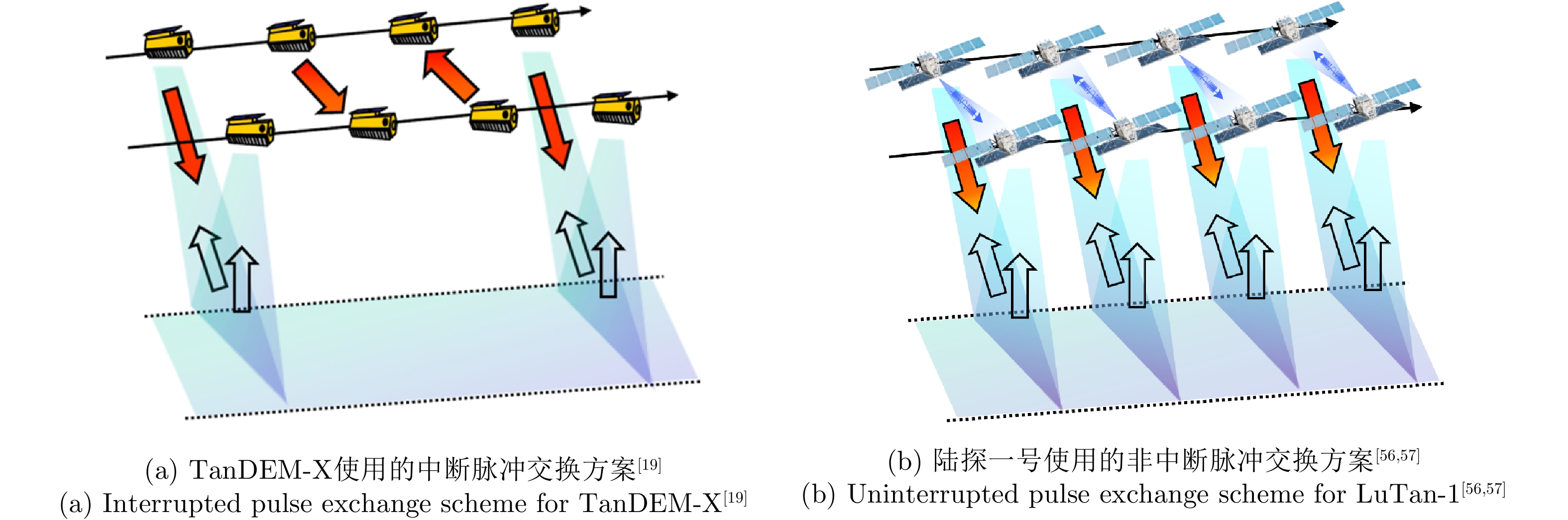
The Concept and System of Very Large Baseline Spaceborne Interferometric Synthetic Aperture Radar
-
摘要: 星载干涉合成孔径雷达(InSAR)技术通过测量雷达视线方向的相位差实现地表高程测量与形变监测。然而,面向未来更高精度的干涉测量需求,InSAR系统设计参数与测量精度的解析模型仍存在关键参数不完备、物理约束刻画不充分等问题,对下一代合成孔径雷达干涉测量技术的发展形成制约。该文针对系统设计参数和测量精度间存在的复杂多因素耦合问题开展研究,详细分析了空间、时间基线星载干涉合成孔径雷达成像理论约束关系,构建了融合多源失相干的空-时误差模型,量化了基线参数与测量精度的非线性关系,建立了涵盖相干性、高程精度、基于相干时间基线的形变灵敏度等关键指标的完备评估框架,在此基础上提出了超长基线星载InSAR的概念与体制。同时,对超长基线星载InSAR的性能进行了详细分析,阐述了超长基线星载InSAR在轨道设计、系统设计、同步方法、误差校正以及相位解缠等方面的技术挑战,介绍了超长基线星载InSAR在高精度高程测量与形变测量以及分布式SAR系统等方面的应用潜力,可为未来新一代高精度、多维度InSAR系统设计提供理论支撑,在地球科学前沿探索与国家重大工程安全保障中发挥更大价值。Abstract: Spaceborne Interferometric Synthetic Aperture Radar (InSAR) enables surface elevation measurement and deformation monitoring by measuring phase differences along the radar line of sight. However, meeting the future demand for higher-precision measurements remains challenging: analytical models linking InSAR system design parameters to measurement accuracy are still limited by incomplete key parameters and insufficient or unclear physical constraints. These limitations restrict the development of next-generation InSAR technology. This study examines the complex multifactor coupling between system design parameters and measurement accuracy. It provides a detailed analysis of the imaging mechanism and theoretical constraints of spaceborne InSAR with spatial and temporal baselines and presents a spatiotemporal error model integrating multisource decorrelation. The nonlinear relationship between baseline parameters and measurement accuracy is quantitatively characterized, and a comprehensive evaluation framework is established based on key indicators such as coherence, elevation accuracy, and coherent temporal baseline-based deformation sensitivity. Built on top of these analysis, the concept and system architecture of very large baseline spaceborne InSAR are proposed, and its performance is analyzed in detail. The associated technical challenges—including orbit configuration, system design, synchronization, error correction, and phase unwrapping—are systematically discussed. Potential applications of this type of InSAR system architecture in high-precision elevation, deformation measurements, and distributed SAR systems are introduced. The proposed framework provides theoretical support for the design of next-generation high-precision, multidimensional InSAR systems and is expected to play a key role in the frontier of Earth science exploration and the safety assurance of major national engineering projects.
-
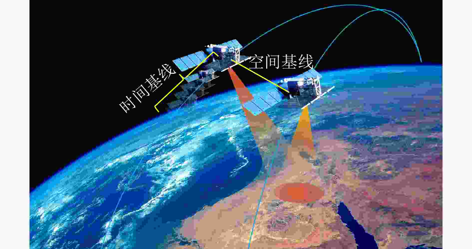
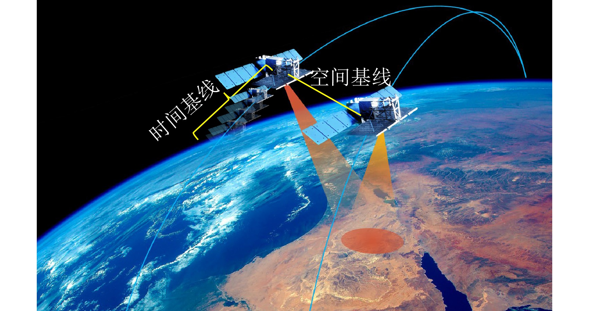
图 1 超长基线合成孔径雷达干涉测量
Figure 1. Very large baseline synthetic aperture radar interferometry
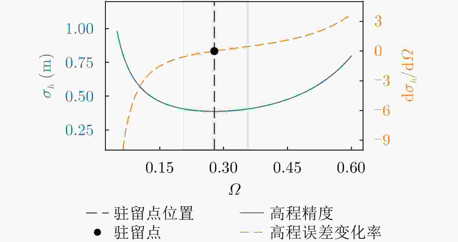
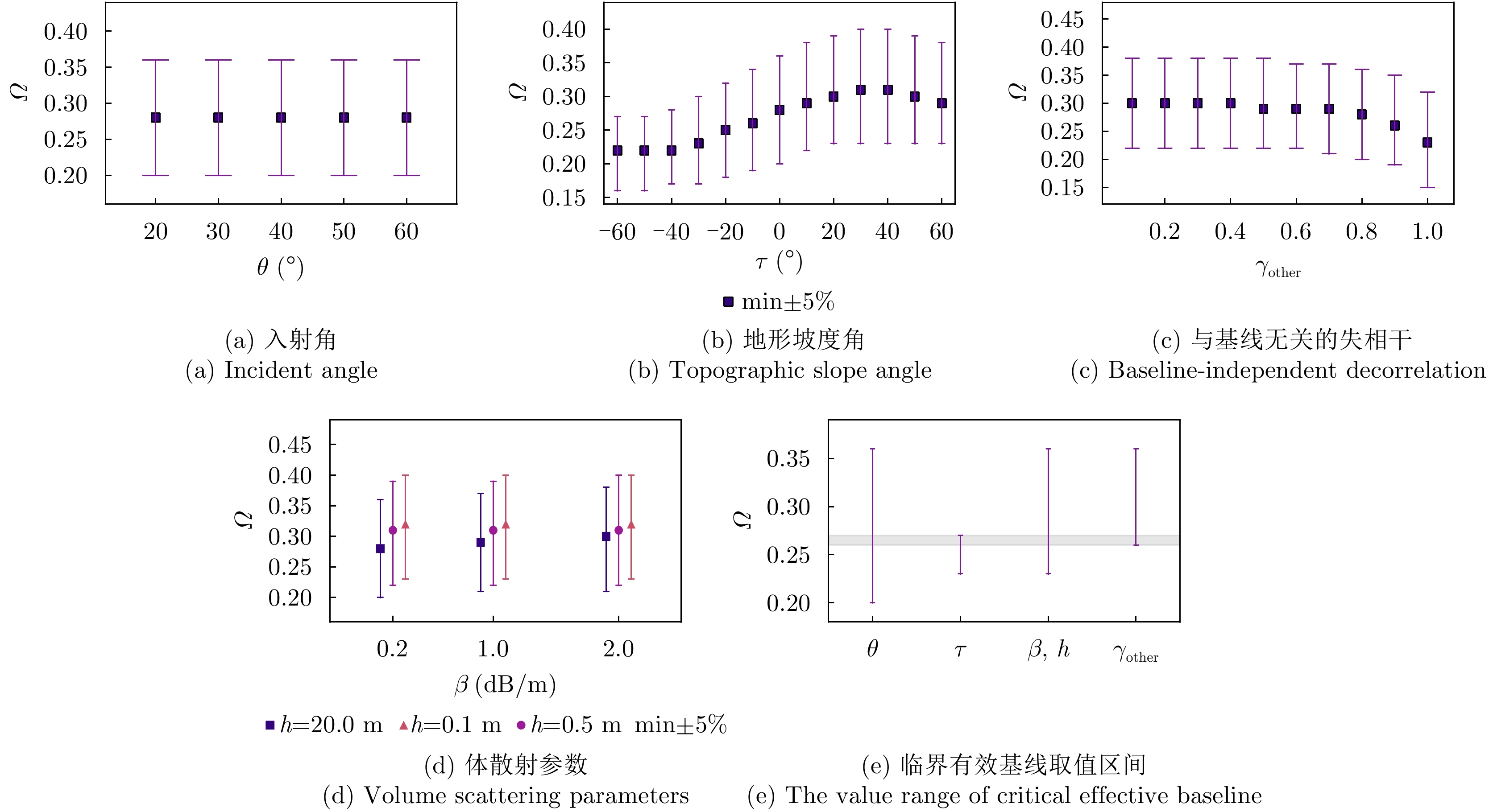
图 2 临界有效基线解析方程(灰色阴影区为5%相对误差邻域)
Figure 2. Analytical equation for critical effective baseline (the gray shaded area denotes the 5% relative error neighborhood)
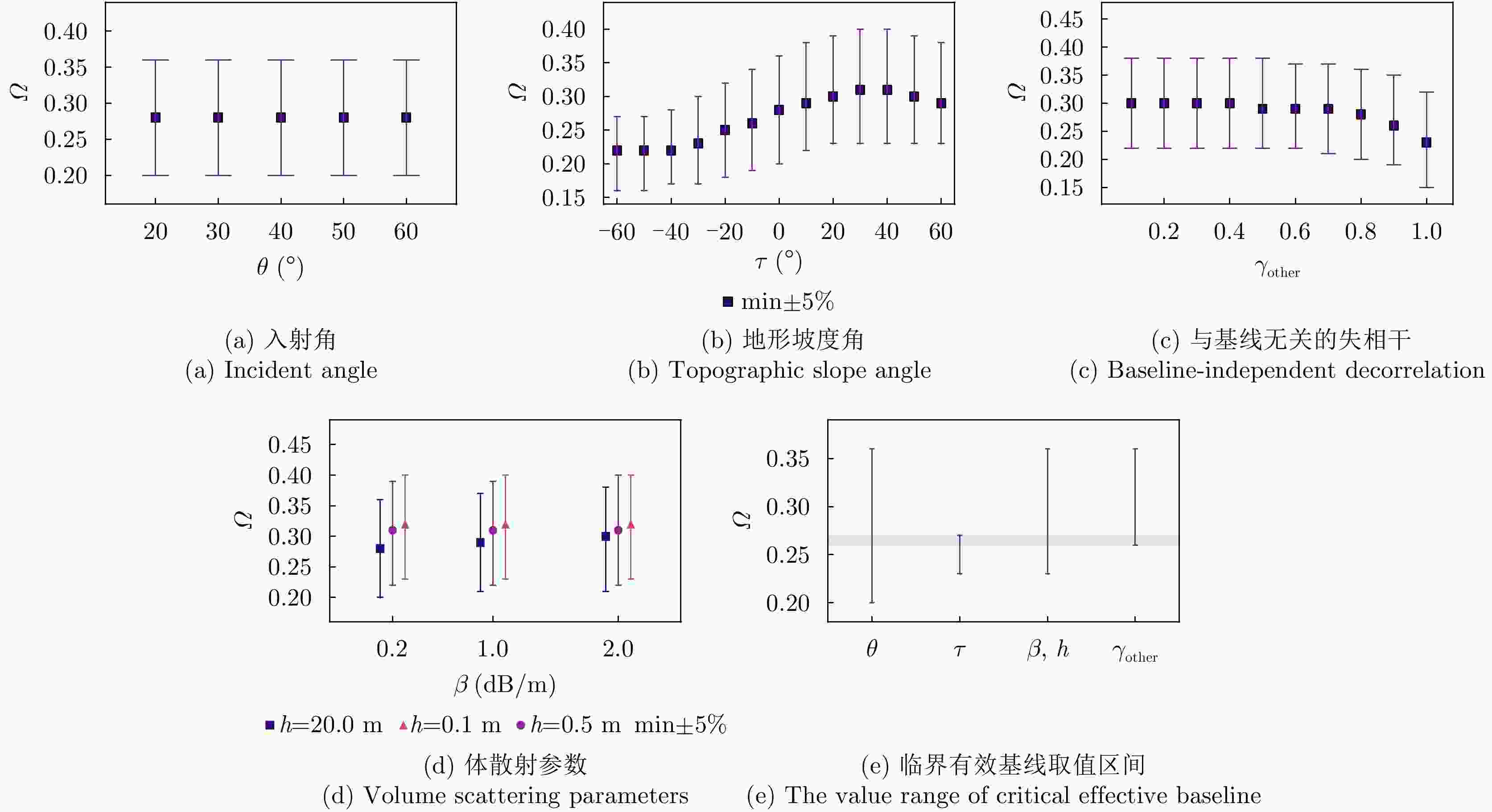
图 3 不同参数变化对临界有效基线取值的影响
Figure 3. Influence of different parameter variations on the value of critical effective baseline

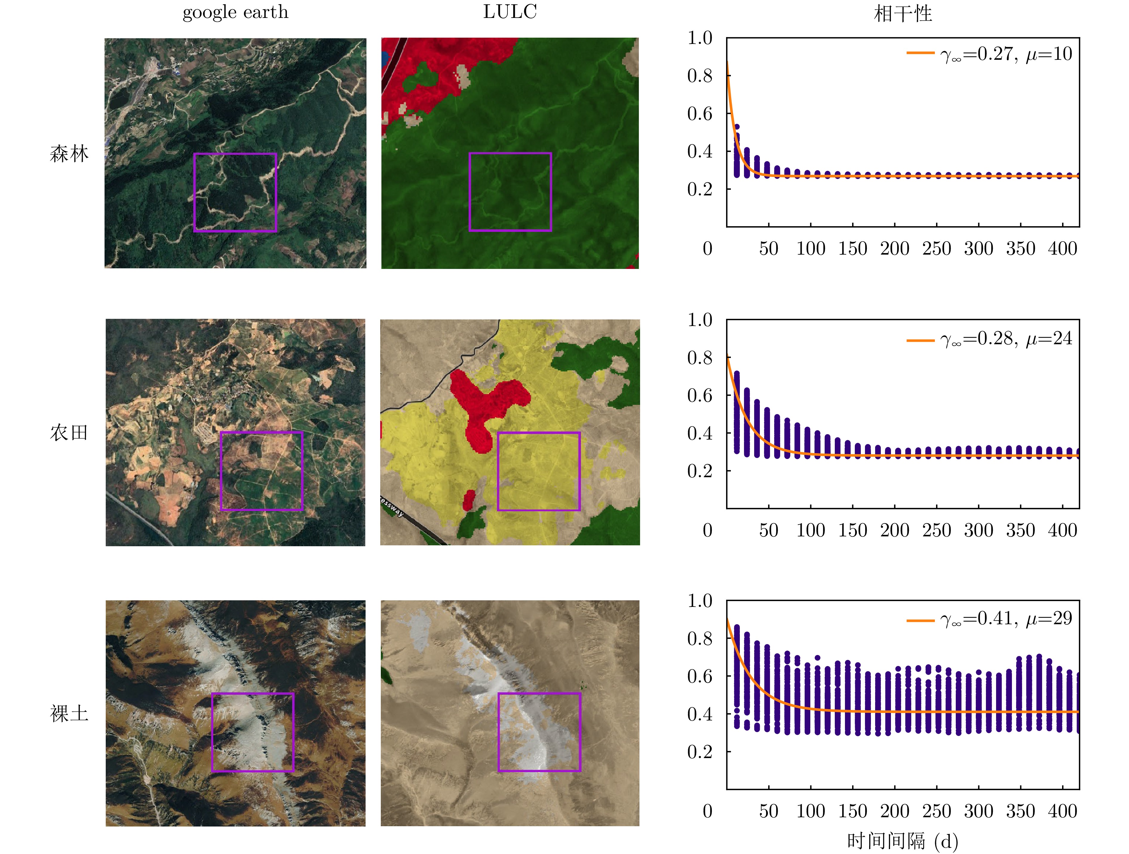
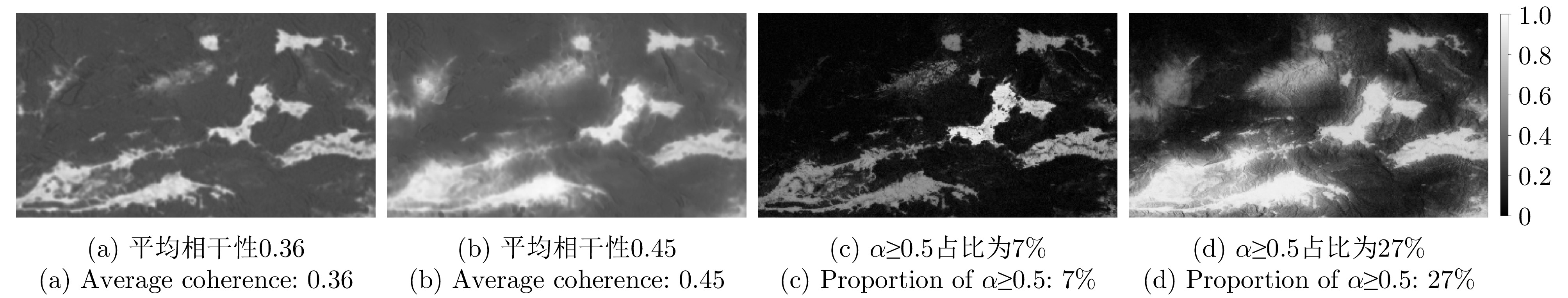
图 4 Sentinel-1在不同地物类型的相干性
Figure 4. Coherence of Sentinel-1 in different land cover types
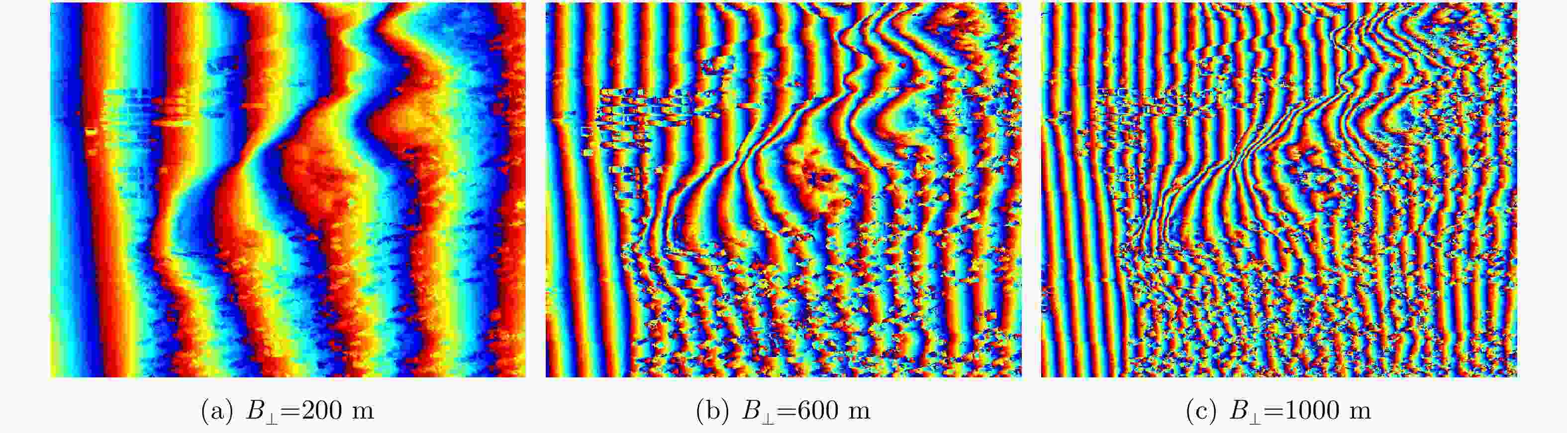
图 6 干涉条纹密集程度与基线的变化关系
Figure 6. Relationship between the density of interferometric fringes and baseline variation
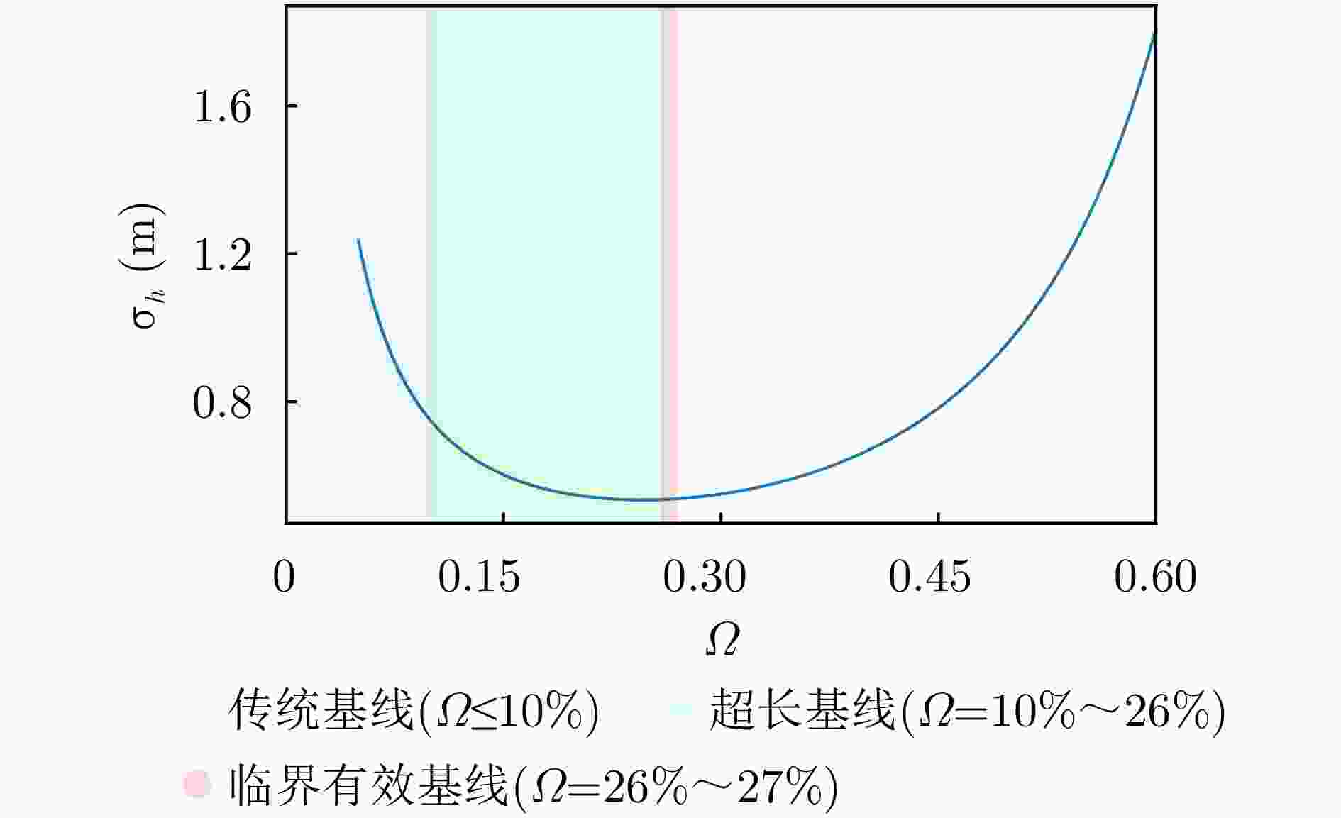
图 7 高程误差随有效基线因子的变化关系
Figure 7. Relationship between elevation error and effective baseline factor

图 9 平均相干性与形变测量精度的关系
Figure 9. Relationship between average coherence and deformation measurement accuracy
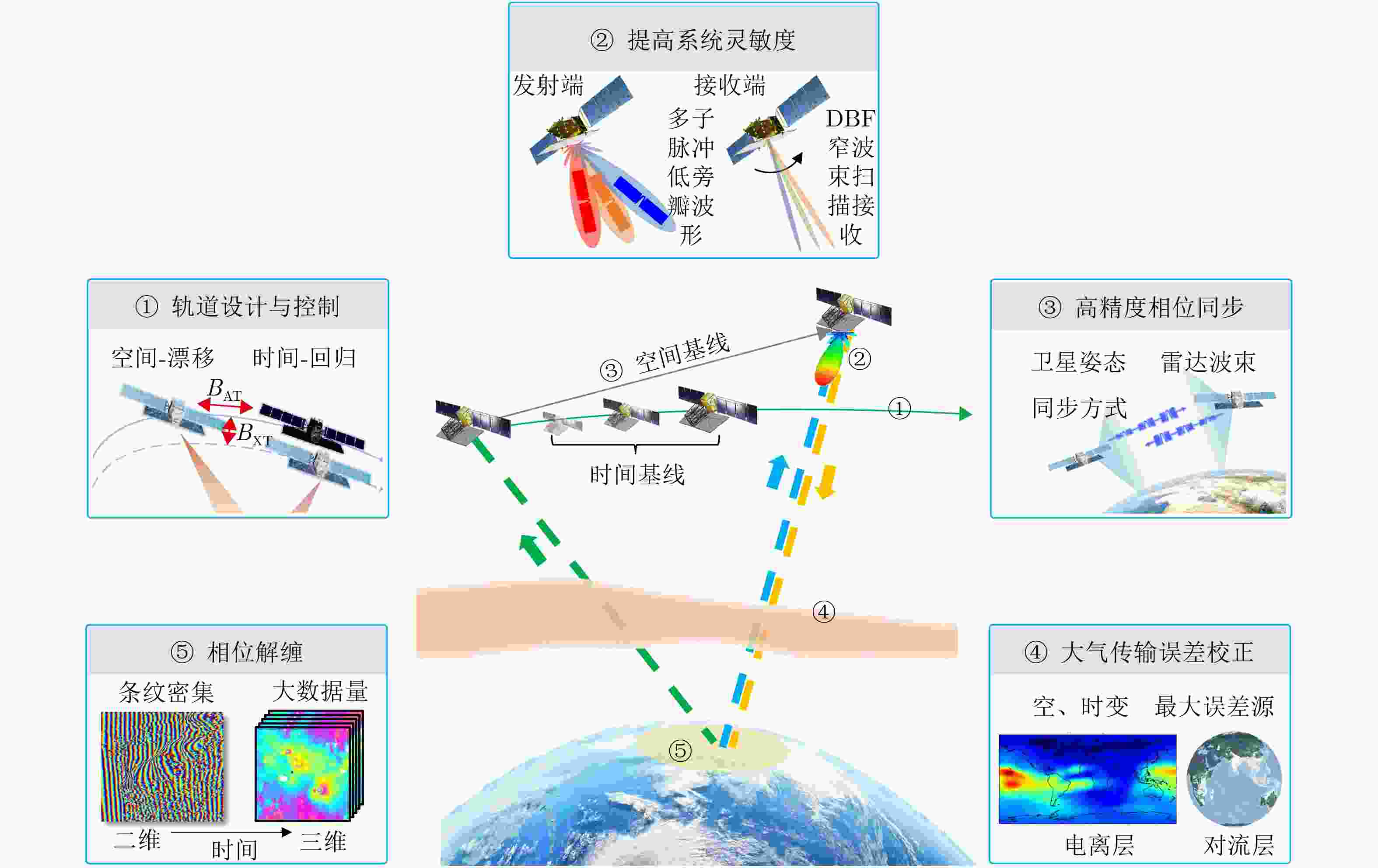
图 10 超长基线InSAR技术挑战概念图
Figure 10. Concept map of technical challenges in very large baseline InSAR
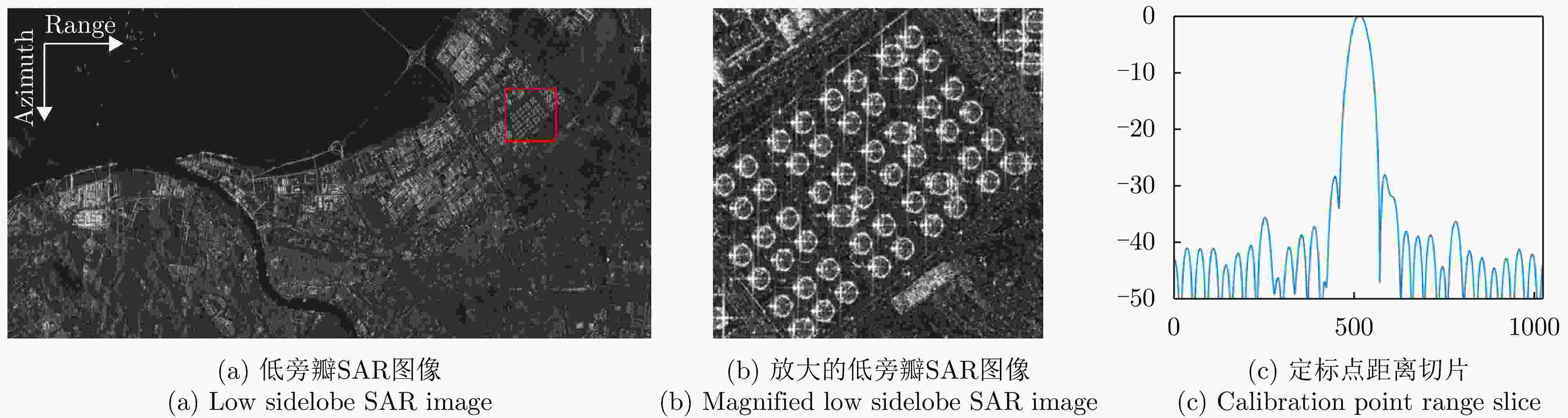
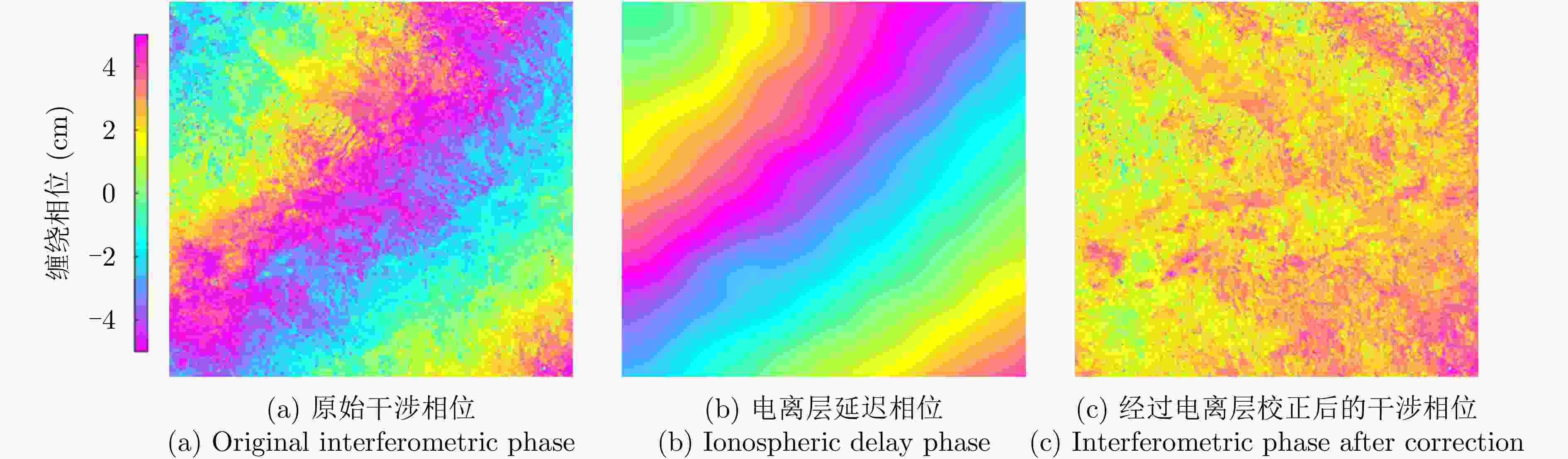
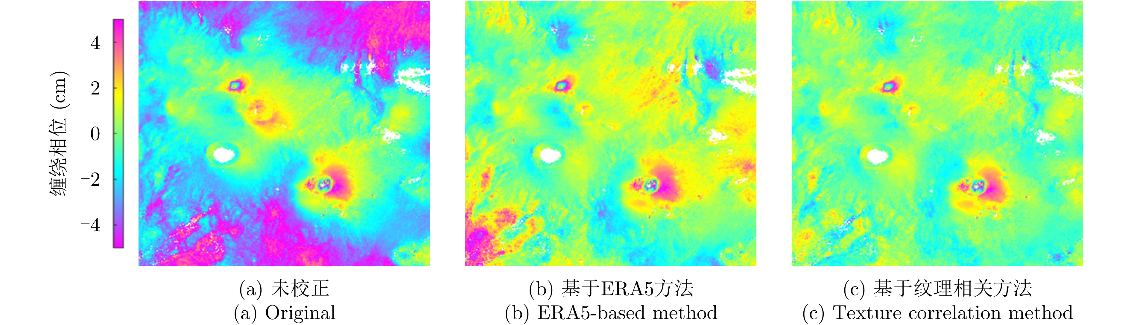
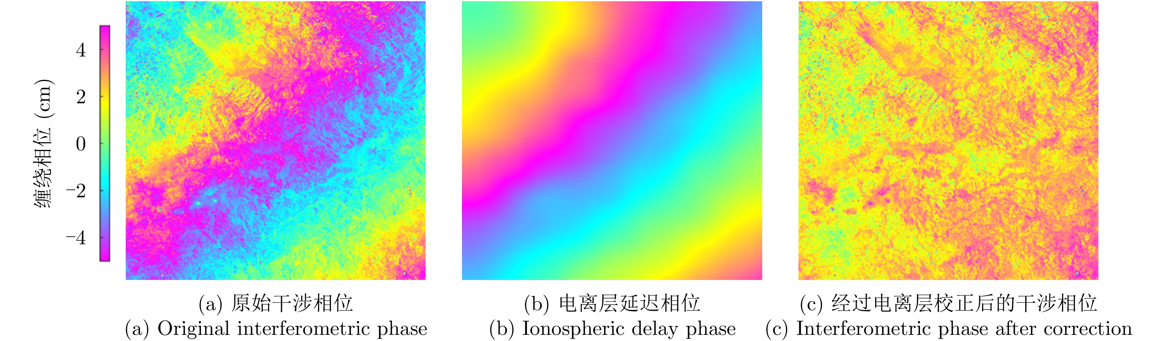
图 17 基于谱分集方法校正L波段ALOS-2电离层延迟相位
Figure 17. Ionospheric delay phase correction of L-band ALOS-2 based on split-spectrum method
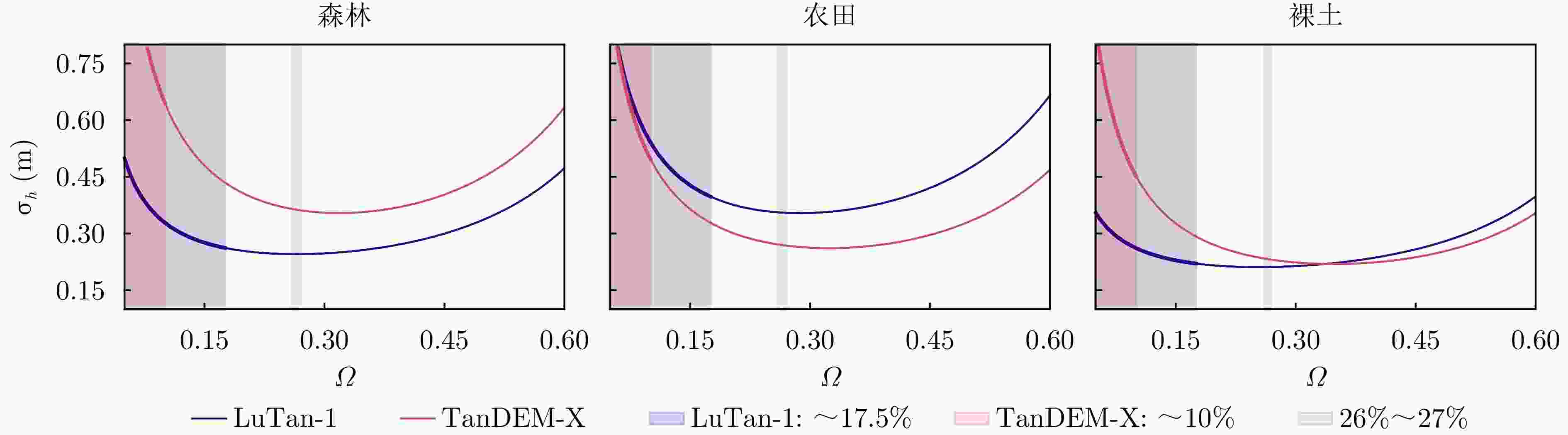
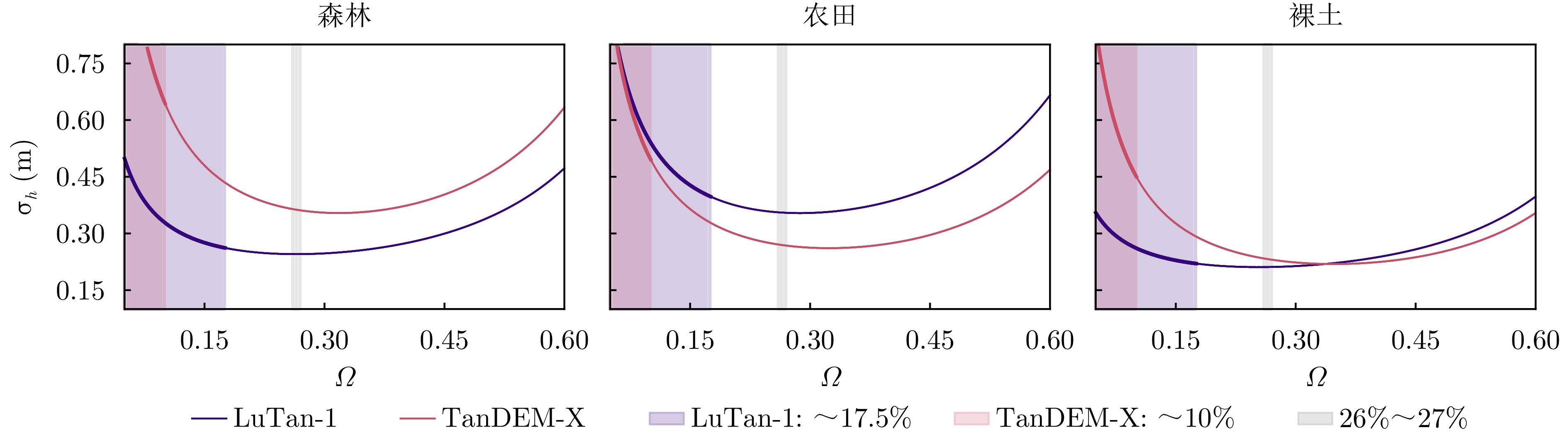
图 19 TanDEM-X和LuTan-1在典型系统参数(见表4)条件下,不同地表覆盖类型下的高程误差
Figure 19. Elevation errors of TanDEM-X and LuTan-1 under different land cover types with typical system parameters (see Tab. 4)
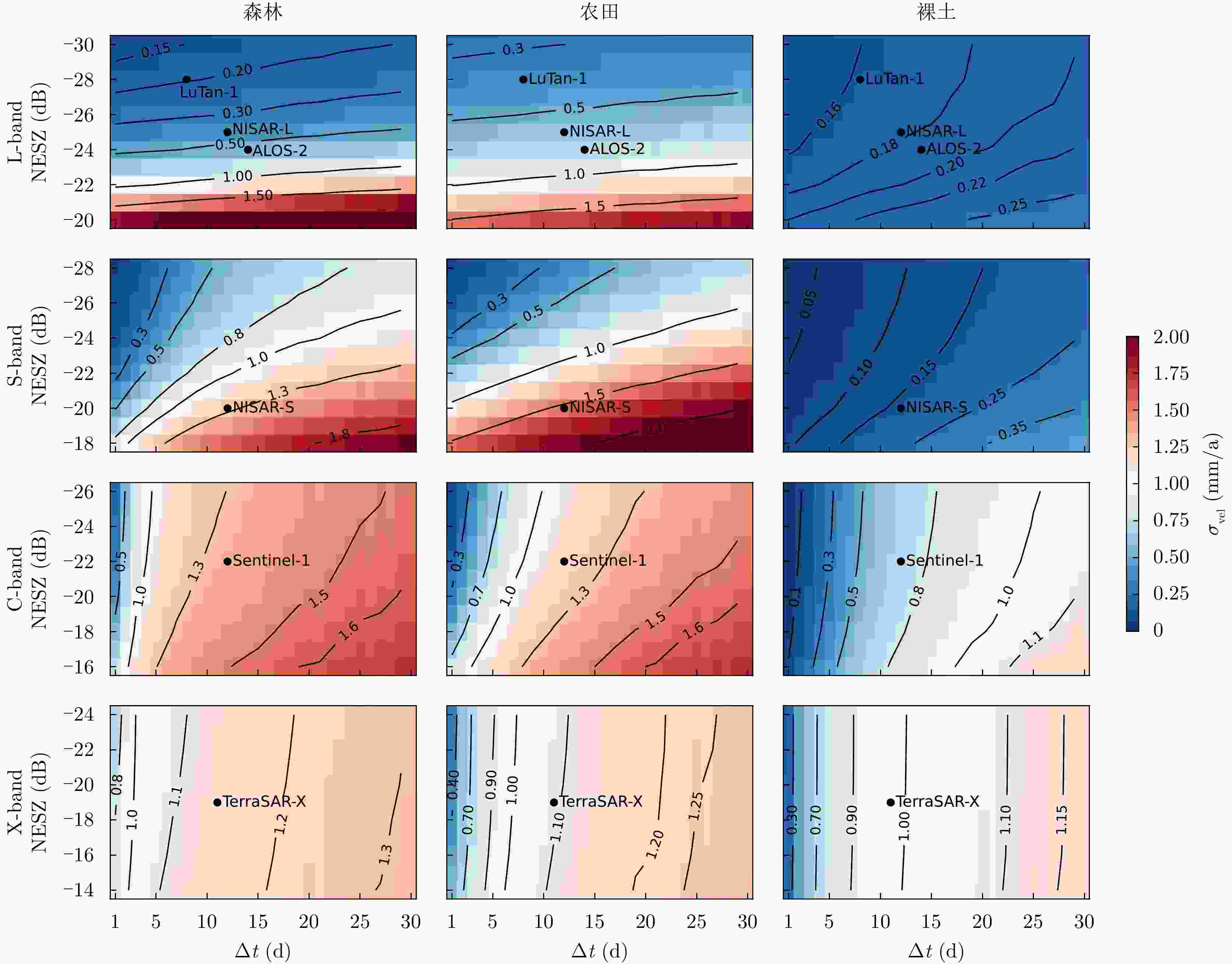
图 20 不同波段、不同地物类型的相干性影响的形变速率测量精度
Figure 20. Deformation velocity measurement accuracy affected by coherence under different frequency bands and different land cover types
表 1 基于临界有效基线解析方程的EBF分类标准
Table 1. Classification standard for EBF based on the analytical equation of critical effective baseline
条件 定义 基线类型 物理意义 $ {\mathrm{d}}{\sigma }_{h}/{\mathrm{d}}{\varOmega } \gt 0 $ $ {\varOmega } \gt 27\mathrm{\% } $ 无效空间基线 失相干成为误差主导因素,此时高程测量相位误差急剧上升,
严重失相干导致测量结果不可信$ {\mathrm{d}}{\sigma }_{h}/{\mathrm{d}}{\varOmega }=0 $ $ {\varOmega }=26\mathrm{\% }{\text{~}}27\mathrm{\% } $ 临界有效空间基线 作为高程误差随EBF变化的分界点,是高程误差收敛至全局最小值(精度最高)的理论边界点;是基线增益与失相干损耗的平衡临界点,标志误差主导因素本质转变;是InSAR系统精度调控拐点,提供量化基线参数最优阈值,对应精度最优状态 $ \begin{aligned}& {\rm d}{\sigma }_{h}/{\rm d }{\varOmega } \lt 0\\& 且{\varOmega } \gt 10\mathrm{\% }\end{aligned} $ $ 10\mathrm{\% } \lt {\varOmega } \lt 26\mathrm{\% } $ 超长空间基线 导数变化变缓,高程精度对基线长度变化仍敏感,但开始出现相干性造成的误差抵消高程精度的提升,控制误差优于提升基线长度,需严格把控失相干误差的影响 $ {\varOmega }\leq 10\mathrm{\% } $ $ {\varOmega }\leq 10\mathrm{\% } $ 传统空间基线[15,17,18] 即传统短基线和长基线。导数快速变化,基线增益起主导作用,
高程精度对基线长度变化敏感 下载: 导出CSV
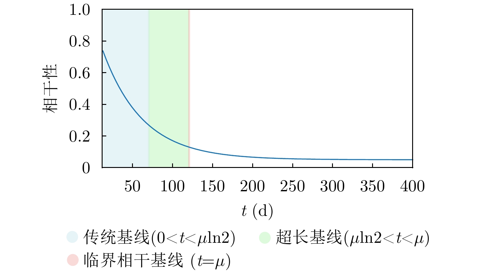
表 2 基于临界相干时间基线模型的时间基线分类标准
Table 2. Classification standard for temporal baseline based on the critical coherence temporal baseline model
定义 基线类型 物理意义 $ t \gt \mu $ 无效时间基线 超出临界相干时间基线,相干性趋近长期值且变化极缓,继续增加基线无显著增益且浪费资源 $ t=\mu $ 临界相干时间基线 相干性衰减速率由快转缓的临界转变点,标志向长期稳定态过渡的理论分界 $ \mu \ln 2 \lt t \lt \mu $ 超长时间基线 长期相干性主导衰减过程,散射体长期统计特性为主要控制因素 $ t=\mu \ln 2 $ 超长时间基线临界点 相干性从短期初始状态主导向长期稳定特性主导过渡的关键节点 $ 0 \lt t \lt \mu \ln 2 $ 传统时间基线 即传统短基线和长基线。初始相干性主导衰减过程,系统参数设计为主要控制因素,
相干性保持较高水平
下载: 导出CSV
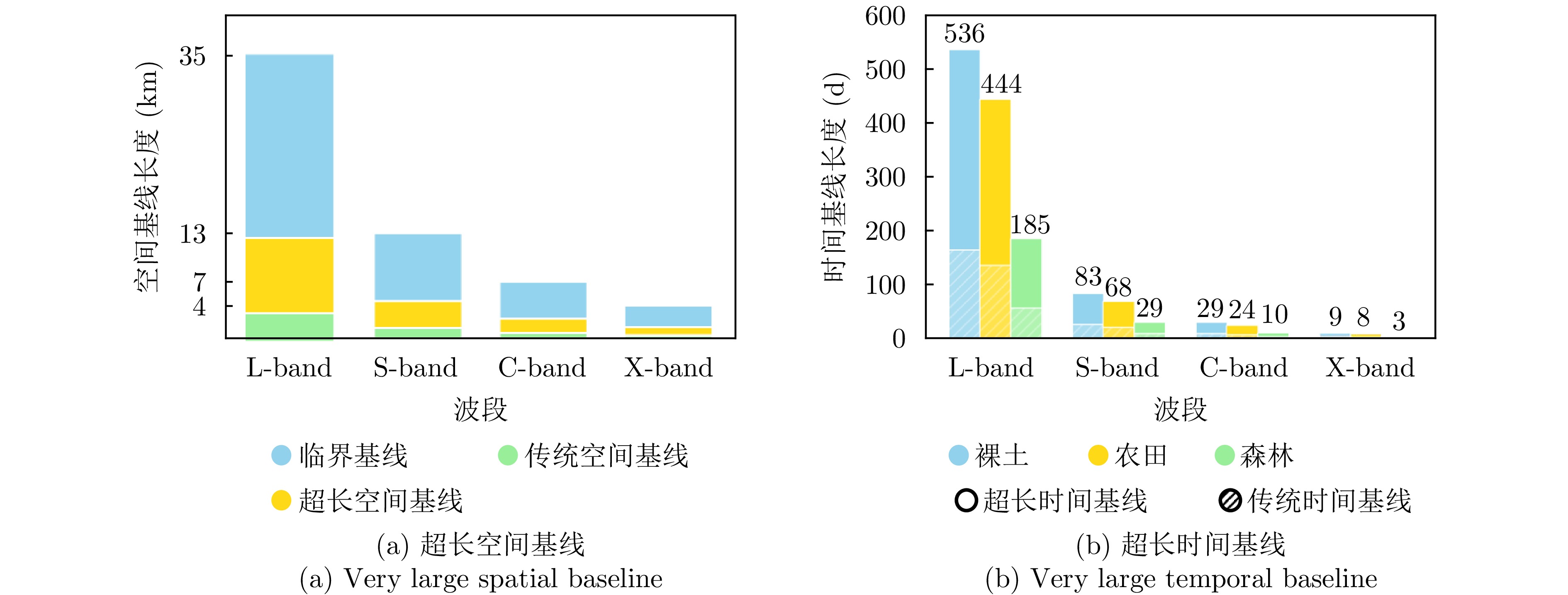
表 3 不同波段、不同地物类型的临界相干时间基线和超长时间基线临界点
Table 3. Critical coherent temporal baseline and very large temporal baseline critical point for different wavebands and different land cover types
波段 临界相干时间基线(d) 超长时间基线临界点(d) 森林 农田 裸土 森林 农田 裸土 L 185 444 536 128 308 371 S 29 68 83 20 47 57 C 10 24 29 7 17 20 X 3 8 9 2 5 6
下载: 导出CSV
表 4 TanDEM-X和LuTan-1的典型参数
Table 4. Typical parameters of TanDEM-X and LuTan-1
参数 TanDEM-X LuTan-1 NESZ –19 dB –28 dB 入射角 35° 35° 距离向带宽 100 MHz 80 MHz
下载: 导出CSV
-
[1] HOWARD H D, ROBERTS S C, and BRANKIN R. Target detection in SAR imagery by genetic programming[J]. Advances in Engineering Software, 1999, 30(5): 303–311. doi: 10.1016/S0965-9978(98)00093-3. [2] KIRK J C, DARDEN S, MAJUMDER U, et al. Forty years of digital SAR and slow GMTI technology[C]. 2014 IEEE Radar Conference, Cincinnati, USA, 2014: 64–69. doi: 10.1109/RADAR.2014.6875556. [3] HENDERSON F M and LEWIS A J. Principles and Applications of Imaging Radar[M]. 3rd ed. John Wiley and Sons, 1998. [4] MATSUOKA M and YAMAZAKI F. Use of satellite SAR intensity imagery for detecting building areas damaged due to earthquakes[J]. Earthquake Spectra, 2004, 20(3): 975–994. doi: 10.1193/1.1774182. [5] GRAHAM L C. Synthetic interferometer radar for topographic mapping[J]. Proceedings of the IEEE, 1974, 62(6): 763–768. doi: 10.1109/PROC.1974.9516. [6] ZINK M, BACHMANN M, BRAUTIGAM B, et al. TanDEM-X: The new global DEM takes shape[J]. IEEE Geoscience and Remote Sensing Magazine, 2014, 2(2): 8–23. doi: 10.1109/MGRS.2014.2318895. [7] FARR T G, ROSEN P A, CARO E, et al. The shuttle radar topography mission[J]. Reviews of Geophysics, 2007, 45(2): RG2004. doi: 10.1029/2005RG000183. [8] VAN NATIJNE A L, BOGAARD T A, VAN LEIJEN F J, et al. World-wide InSAR sensitivity index for landslide deformation tracking[J]. International Journal of Applied Earth Observation and Geoinformation, 2022, 111: 102829. doi: 10.1016/j.jag.2022.102829. [9] BEKAERT D P S, HANDWERGER A L, AGRAM P, et al. InSAR-based detection method for mapping and monitoring slow-moving landslides in remote regions with steep and mountainous terrain: An application to Nepal[J]. Remote Sensing of Environment, 2020, 249: 111983. doi: 10.1016/j.rse.2020.111983. [10] MACCHIARULO V, MILILLO P, DEJONG M J, et al. Integrated InSAR monitoring and structural assessment of tunnelling-induced building deformations[J]. Structural Control and Health Monitoring, 2021, 28(9): e2781. doi: 10.1002/stc.2781. [11] ZEBKER H A and GOLDSTEIN R M. Topographic mapping from interferometric synthetic aperture radar observations[J]. Journal of Geophysical Research: Solid Earth, 1986, 91(B5): 4993–4999. doi: 10.1029/JB091iB05p04993. [12] MASSONNET D, ROSSI M, CARMONA C, et al. The displacement field of the Landers earthquake mapped by radar interferometry[J]. Nature, 1993, 364(6433): 138–142. doi: 10.1038/364138a0. [13] ZEBKER H A and VILLASENOR J. Decorrelation in interferometric radar echoes[J]. IEEE Transactions on Geoscience and Remote Sensing, 1992, 30(5): 950–959. doi: 10.1109/36.175330. [14] ROSEN P A, HENSLEY S, JOUGHIN I R, et al. Synthetic aperture radar interferometry[J]. Proceedings of the IEEE, 2000, 88(3): 333–382. doi: 10.1109/5.838084. [15] ROSEN P A, HENSLEY S, WHEELER K, et al. UAVSAR: A new NASA airborne SAR system for science and technology research[C]. 2006 IEEE Conference on Radar, Verona, USA, 2006: 8. doi: 10.1109/RADAR.2006.1631770. [16] CHANG Zhanqiang, ZHANG Jianbo, GONG Huili, et al. ‘Maximal effective baseline’ for conventional SAR interferometry[J]. International Journal of Remote Sensing, 2007, 28(24): 5603–5615. doi: 10.1080/01431160701227646. [17] KRIEGER G and MOREIRA A. Spaceborne Interferometric and Multistatic SAR Systems[M]. CHERNIAKOV M. Bistatic Radar: Emerging Technology. Chichester: John Wiley & Sons, Ltd, 2008: 95–158. doi: 10.1002/9780470985755.ch4. [18] KRIEGER G, HAJNSEK I, PAPATHANASSIOU K P, et al. Interferometric synthetic aperture radar (SAR) missions employing formation flying[J]. Proceedings of the IEEE, 2010, 98(5): 816–843. doi: 10.1109/JPROC.2009.2038948. [19] KRIEGER G, MOREIRA A, FIEDLER H, et al. TanDEM-X: A satellite formation for high-resolution SAR interferometry[J]. IEEE Transactions on Geoscience and Remote Sensing, 2007, 45(11): 3317–3341. doi: 10.1109/TGRS.2007.900693. [20] ROCCA F. Modeling interferogram stacks[J]. IEEE Transactions on Geoscience and Remote Sensing, 2007, 45(10): 3289–3299. doi: 10.1109/TGRS.2007.902286. [21] PARIZZI A, CONG Xiaoying, and EINEDER M. First results from multifrequency interferometry. A comparison of different decorrelation time constants at L, C and X band[C]. Fringe 2009 Workshop, Frascati, Italy, 2009. [22] HORST S, CHRONE J, DEACON S, et al. NASA’s surface deformation and change mission study[C]. 2021 IEEE Aerospace Conference (50100), Big Sky, USA, 2021: 1–19. doi: 10.1109/AERO50100.2021.9438290. [23] KELLNDORFER J, CARTUS O, LAVALLE M, et al. Global seasonal Sentinel-1 interferometric coherence and backscatter data set[J]. Scientific Data, 2022, 9(1): 73. doi: 10.1038/s41597-022-01189-6. [24] HANSSEN R F. Radar Interferometry: Data Interpretation and Error Analysis[M]. Dordrecht: Springer, 2001. doi: 10.1007/0-306-47633-9. [25] RODRIGUEZ E and MARTIN J M. Theory and design of interferometric synthetic aperture radars[J]. IEE Proceedings F (Radar and Signal Processing), 1992, 139(2): 147–159. doi: 10.1049/ip-f-2.1992.0018. [26] BAMLER R and HARTL P. Synthetic aperture radar interferometry[J]. Inverse Problems, 1998, 14(4): R1–R54. doi: 10.1088/0266-5611/14/4/001. [27] TREUHAFT R N and SIQUEIRA P R. Vertical structure of vegetated land surfaces from interferometric and polarimetric radar[J]. Radio Science, 2000, 35(1): 141–177. doi: 10.1029/1999RS900108. [28] BAMLER R and JUST D. Phase statistics and decorrelation in SAR interferograms[C]. IEEE International Geoscience and Remote Sensing Symposium, Tokyo, Japan, 1993: 980–984. doi: 10.1109/IGARSS.1993.322637. [29] BILLINGS S A. Parameter estimation: Principles and problems[J]. Electronics and Power, 1981, 27(5): 413. doi: 10.1049/ep.1981.0202. [30] JOUGHIN I R, WINEBRENNER D P, and PERCIVAL D B. Probability density functions for multilook polarimetric signatures[J]. IEEE Transactions on Geoscience and Remote Sensing, 1994, 32(3): 562–574. doi: 10.1109/36.297975. [31] LEE J S, HOPPEL K W, MANGO S A, et al. Intensity and phase statistics of multilook polarimetric and interferometric SAR imagery[J]. IEEE Transactions on Geoscience and Remote Sensing, 1994, 32(5): 1017–1028. doi: 10.1109/36.312890. [32] TOUZI R and LOPES A. Statistics of the Stokes parameters and of the complex coherence parameters in one-look and multilook speckle fields[J]. IEEE Transactions on Geoscience and Remote Sensing, 1996, 34(2): 519–531. doi: 10.1109/36.485128. [33] TURNER II B L, LAMBIN E F, and REENBERG A. The emergence of land change science for global environmental change and sustainability[J]. Proceedings of the National Academy of Sciences of the United States of America, 2007, 104(52): 20666–20671. doi: 10.1073/pnas.0704119104. [34] WANG Yanzhao, SUN Yonghua, CAO Xuyue, et al. A review of regional and global scale land use/land cover (LULC) mapping products generated from satellite remote sensing[J]. ISPRS Journal of Photogrammetry and Remote Sensing, 2023, 206: 311–334. doi: 10.1016/j.isprsjprs.2023.11.014. [35] KARRA K, KONTGIS C, STATMAN-WEIL Z, et al. Global land use / land cover with Sentinel 2 and deep learning[C]. 2021 IEEE International Geoscience and Remote Sensing Symposium IGARSS, Brussels, Belgium, 2021: 4704–4707. doi: 10.1109/IGARSS47720.2021.9553499. [36] ROSEN P A, GURROLA E, SACCO G F, et al. The InSAR scientific computing environment[C]. 9th European Conference on Synthetic Aperture Radar, Nuremberg, Germany, 2012: 730–733. [37] FATTAHI H, AGRAM P, and SIMONS M. A network-based enhanced spectral diversity approach for tops time-series analysis[J]. IEEE Transactions on Geoscience and Remote Sensing, 2017, 55(2): 777–786. doi: 10.1109/TGRS.2016.2614925. [38] PEPE A and LANARI R. On the extension of the minimum cost flow algorithm for phase unwrapping of multitemporal differential SAR interferograms[J]. IEEE Transactions on Geoscience and Remote Sensing, 2006, 44(9): 2374–2383. doi: 10.1109/TGRS.2006.873207. [39] 李楠, 丛琳, 陈重华, 等. 多约束条件分布式InSAR编队构形工程优化方法[J]. 测绘学报, 2022, 51(12): 2440–2447. doi: 10.11947/j.AGCS.2022.20210381.LI Nan, CONG Lin, CHEN Chonghua, et al. An engineering optimization method for distributed spaceborne InSAR formation configuration based on multiple constraints[J]. Acta Geodaetica et Cartographica Sinica, 2022, 51(12): 2440–2447. doi: 10.11947/j.AGCS.2022.20210381. [40] 李楠, 温俊健, 刘艳阳, 等. L波段差分干涉SAR卫星严格回归轨道优化设计方法[J]. 测绘学报, 2024, 53(10): 1873–1880. doi: 10.11947/j.AGCS.2024.20230250.LI Nan, WEN Junjian, LIU Yanyang, et al. An strictly-regressive orbit optimization algorithm for L-band differential interferometric SAR satellite[J]. Acta Geodaetica et Cartographica Sinica, 2024, 53(10): 1873–1880. doi: 10.11947/j.AGCS.2024.20230250. [41] SCHWEIGHART S A and SEDWICK R J. High-fidelity linearized J2 model for satellite formation flight[J]. Journal of Guidance, Control, and Dynamics, 2002, 25(6): 1073–1080. doi: 10.2514/2.4986. [42] 邵凯, 张厚喆, 秦显平, 等. 分布式InSAR编队卫星精密绝对和相对轨道确定[J]. 测绘学报, 2021, 50(5): 580–588. doi: 10.11947/j.AGCS.2021.20200415.SHAO Kai, ZHANG Houzhe, QIN Xianping, et al. Precise absolute and relative orbit determination for distributed InSAR satellite system[J]. Acta Geodaetica et Cartographica Sinica, 2021, 50(5): 580–588. doi: 10.11947/j.AGCS.2021.20200415. [43] 邓云凯, 禹卫东, 张衡, 等. 未来星载SAR技术发展趋势[J]. 雷达学报, 2020, 9(1): 1–33. doi: 10.12000/JR20008.DENG Yunkai, YU Weidong, ZHANG Heng, et al. Forthcoming spaceborne SAR development[J]. Journal of Radars, 2020, 9(1): 1–33. doi: 10.12000/JR20008. [44] RINCON R F, VEGA M A, BUENFIL M, et al. NASA’s L-band digital beamforming synthetic aperture radar[J]. IEEE Transactions on Geoscience and Remote Sensing, 2011, 49(10): 3622–3628. doi: 10.1109/TGRS.2011.2157971. [45] SCHAEFER C, HEER C, and LUDWIG M. X-band demonstrator for receive-only frontend with digital beamforming[C]. 8th European Conference on Synthetic Aperture Radar, Aachen, Germany, 2010: 1–4. [46] WANG Wei, WANG Robert, DENG Yunkai, et al. An improved processing scheme of digital beam-forming in elevation for reducing resource occupation[J]. IEEE Geoscience and Remote Sensing Letters, 2016, 13(3): 309–313. doi: 10.1109/LGRS.2015.2508098. [47] QIU Jinsong, ZHANG Zhimin, WANG Robert, et al. A novel weight generator in real-time processing architecture of DBF-SAR[J]. IEEE Transactions on Geoscience and Remote Sensing, 2022, 60: 5204915. doi: 10.1109/TGRS.2021.3067882. [48] ZHAO Qingchao, ZHANG Yi, WANG Wei, et al. On the frequency dispersion in DBF SAR and digital scalloped beamforming[J]. IEEE Transactions on Geoscience and Remote Sensing, 2020, 58(5): 3619–3632. doi: 10.1109/TGRS.2019.2958863. [49] ZHOU Yashi, WANG Wei, CHEN Zhen, et al. Digital beamforming synthetic aperture radar (DBSAR): Experiments and performance analysis in support of 16-channel airborne X-band SAR data[J]. IEEE Transactions on Geoscience and Remote Sensing, 2021, 59(8): 6784–6798. doi: 10.1109/TGRS.2020.3027691. [50] DOERRY A W. SAR processing with non-linear FM chirp waveforms[R]. SAND2006-7729, 2006. [51] ZHANG Yongwei, WANG Wei, WANG Robert, et al. A novel NLFM waveform with low sidelobes based on modified Chebyshev window[J]. IEEE Geoscience and Remote Sensing Letters, 2020, 17(5): 814–818. doi: 10.1109/LGRS.2019.2930817. [52] JIN Guodong, DENG Yunkai, WANG Robert, et al. An advanced nonlinear frequency modulation waveform for radar imaging with low sidelobe[J]. IEEE Transactions on Geoscience and Remote Sensing, 2019, 57(8): 6155–6168. doi: 10.1109/TGRS.2019.2904627. [53] JIN Guodong, LIU Kaiyu, DENG Yunkai, et al. Nonlinear frequency modulation signal generator in LT-1[J]. IEEE Geoscience and Remote Sensing Letters, 2019, 16(10): 1570–1574. doi: 10.1109/LGRS.2019.2905359. [54] WANG Wei, WANG Robert, ZHANG Zhimin, et al. First demonstration of airborne SAR with nonlinear FM chirp waveforms[J]. IEEE Geoscience and Remote Sensing Letters, 2016, 13(2): 247–251. doi: 10.1109/LGRS.2015.2508102. [55] DENG Yunkai and WANG Robert. Exploration of advanced bistatic SAR experiments[J]. Journal of Radars, 2014, 3(1): 1–9. doi: 10.3724/SP.J.1300.2014.14026. [56] WANG Robert, LIU Kaiyu, LIU Dacheng, et al. LuTan-1: An innovative L-band spaceborne bistatic interferometric synthetic aperture radar mission[J]. IEEE Geoscience and Remote Sensing Magazine, 2025, 13(2): 58–78. doi: 10.1109/MGRS.2024.3478761. [57] LIANG Da, LIU Kaiyu, ZHANG Heng, et al. The processing framework and experimental verification for the noninterrupted synchronization scheme of LuTan-1[J]. IEEE Transactions on Geoscience and Remote Sensing, 2021, 59(7): 5740–5750. doi: 10.1109/TGRS.2020.3024561. [58] 吴一戎, 洪文, 张冰尘, 等. 稀疏微波成像研究进展(科普类)[J]. 雷达学报, 2014, 3(4): 383–395. doi: 10.3724/SP.J.1300.2014.14105.WU Yirong, HONG Wen, ZHANG Bingchen, et al. Current developments of sparse microwave imaging[J]. Journal of Radars, 2014, 3(4): 383–395. doi: 10.3724/SP.J.1300.2014.14105. [59] LIANG Da, LIU Kaiyu, ZHANG Heng, et al. A high-accuracy synchronization phase-compensation method based on Kalman filter for bistatic synthetic aperture radar[J]. IEEE Geoscience and Remote Sensing Letters, 2020, 17(10): 1722–1726. doi: 10.1109/LGRS.2019.2952475. [60] CAI Yonghua, WANG Robert, YU Weidong, et al. An advanced approach to improve synchronization phase accuracy with compressive sensing for LT-1 bistatic spaceborne SAR[J]. Remote Sensing, 2022, 14(18): 4621. doi: 10.3390/rs14184621. [61] WANG Jili, LI Hongxiang, ZHANG Heng, et al. Demonstration of single-pass spaceborne multi-baseline InSAR result of Hongtu-1 constellation[C]. IGARSS 2024-2024 IEEE International Geoscience and Remote Sensing Symposium, Athens, Greece, 2024: 10881–10884. doi: 10.1109/IGARSS53475.2024.10642742. [62] DENG Yunkai, ZHANG Heng, LIU Kaiyu, et al. Hongtu-1: The first spaceborne single-pass multibaseline SAR interferometry mission[J]. IEEE Transactions on Geoscience and Remote Sensing, 2025, 63: 5202518. doi: 10.1109/TGRS.2024.3523299. [63] LIANG Da, ZHANG Heng, CAI Yonghua, et al. An advanced phase synchronization scheme based on coherent integration and waveform diversity for bistatic SAR[J]. Remote Sensing, 2021, 13(5): 981. doi: 10.3390/rs13050981. [64] CAI Yonghua, LI Junfeng, YANG Qingyue, et al. First demonstration of RFI mitigation in the phase synchronization of LT-1 bistatic SAR[J]. IEEE Transactions on Geoscience and Remote Sensing, 2023, 61: 5217319. doi: 10.1109/TGRS.2023.3310613. [65] CAI Yonghua, LI Junfeng, WANG Yachao, et al. Detecting and removing phase jitters for the phase synchronization of LT-1 bistatic SAR[J]. IEEE Geoscience and Remote Sensing Letters, 2023, 20: 4011705. doi: 10.1109/LGRS.2023.3318125. [66] CHEN Yuesheng, NAN Yijiang, CAI Yonghua, et al. Joint narrowband RFI suppression and phase synchronization signal retrieval for BiSAR via robust principal component analysis[J]. IEEE Journal of Selected Topics in Applied Earth Observations and Remote Sensing, 2024, 17: 17461–17470. doi: 10.1109/JSTARS.2024.3419256. [67] CHEN Yuesheng, CAI Yonghua, NAN Yijiang, et al. An advanced RFI mitigation scheme for phase synchronization of bistatic SAR based on blind source separation[J]. IEEE Transactions on Geoscience and Remote Sensing, 2023, 61: 5222513. doi: 10.1109/TGRS.2023.3333372. [68] 蔡永华. 星载双基多通道SAR时相同步与误差校正技术研究[D]. [博士论文], 中国科学院大学, 2024.CAI Yonghua. Research on time phase synchronization and error correction technology for spaceborne bistatic multichannel SAR[D]. [Ph.D. dissertation], University of Chinese Academy of Sciences, 2024. [69] BERRADA BABY H, GOLÉ P, and LAVERGNAT J. A model for the tropospheric excess path length of radio waves from surface meteorological measurements[J]. Radio Science, 1988, 23(6): 1023–1038. doi: 10.1029/RS023i006p01023. [70] HERSBACH H, BELL B, BERRISFORD P, et al. The ERA5 global reanalysis[J]. Quarterly Journal of the Royal Meteorological Society, 2020, 146(730): 1999–2049. doi: 10.1002/qj.3803. [71] YANG Qingyue, ZHANG Yunjun, and WANG Robert. Heterogeneous InSAR tropospheric correction based on local texture correlation[J]. IEEE Transactions on Geoscience and Remote Sensing, 2024, 62: 5203814. doi: 10.1109/TGRS.2024.3356749. [72] GOMBA G, PARIZZI A, DE ZAN F, et al. Toward operational compensation of ionospheric effects in SAR interferograms: The split-spectrum method[J]. IEEE Transactions on Geoscience and Remote Sensing, 2016, 54(3): 1446–1461. doi: 10.1109/TGRS.2015.2481079. [73] LIANG Cunren, AGRAM P, SIMONS M, et al. Ionospheric correction of InSAR time series analysis of C-band Sentinel-1 TOPS data[J]. IEEE Transactions on Geoscience and Remote Sensing, 2019, 57(9): 6755–6773. doi: 10.1109/TGRS.2019.2908494. [74] NING Jiaqi, WANG Robert, WANG Jili, et al. Ionospheric correction of ALOS-2 full-aperture ScanSAR interferometric data for surface deformation measurement in Beijing[J]. The Journal of Engineering, 2019, 2019(19): 5685–5688. doi: 10.1049/joe.2019.0331. [75] LI Shijin, ZHANG Shubi, LI Tao, et al. Modeling the optimal baseline for a spaceborne bistatic SAR system to generate DEMs[J]. ISPRS International Journal of Geo-Information, 2020, 9(2): 108. doi: 10.3390/ijgi9020108. [76] HU Fengming, XU Feng, WANG Robert, et al. Conceptual study and performance analysis of TanDEM multi-antenna spaceborne SAR interferometry[J]. Journal of Remote Sensing, 2024, 4: 0137. doi: 10.34133/remotesensing.0137. [77] WU Zhipeng, WANG Teng, WANG Yingjie, et al. Deep learning for the detection and phase unwrapping of mining-induced deformation in large-scale interferograms[J]. IEEE Transactions on Geoscience and Remote Sensing, 2022, 60: 5216318. doi: 10.1109/TGRS.2021.3121907. [78] 江利明, 邵益, 周志伟, 等. 智能化InSAR数据处理研究进展、挑战与展望[J]. 测绘学报, 2024, 53(6): 1037–1056. doi: 10.11947/j.AGCS.2024.20230440.JIANG Liming, SHAO Yi, ZHOU Zhiwei, et al. A review of intelligent InSAR data processing: Recent advancements, challenges and prospects[J]. Acta Geodaetica et Cartographica Sinica, 2024, 53(6): 1037–1056. doi: 10.11947/j.AGCS.2024.20230440. [79] 陈军, 刘万增, 武昊, 等. 智能化测绘的基本问题与发展方向[J]. 测绘学报, 2021, 50(8): 995–1005. doi: 10.11947/j.AGCS.2021.20210235.CHEN Jun, LIU Wanzeng, WU Hao, et al. Smart surveying and mapping: Fundamental issues and research agenda[J]. Acta Geodaetica et Cartographica Sinica, 2021, 50(8): 995–1005. doi: 10.11947/j.AGCS.2021.20210235. [80] LÓPEZ-DEKKER P, BIGGS J, CHAPRON B, et al. The Harmony mission: End of phase-0 science overview[C]. 2021 IEEE International Geoscience and Remote Sensing Symposium IGARSS, Brussels, Belgium, 2021: 7752–7755. doi: 10.1109/IGARSS47720.2021.9554896. [81] 唐新明, 李涛, 张祥, 等. L波段差分干涉SAR卫星在轨应用关键参数测试分析[J]. 测绘学报, 2024, 53(10): 1863–1872. doi: 10.11947/j.AGCS.2024.20230240.TANG Xinming, LI Tao, ZHANG Xiang, et al. In-orbit application parameters test and analysis of L-band differential interferometric SAR satellite constellation[J]. Acta Geodaetica et Cartographica Sinica, 2024, 53(10): 1863–1872. doi: 10.11947/j.AGCS.2024.20230240. [82] 许兵, 朱焱, 李志伟, 等. 国产卫星时序InSAR形变监测精度分析[J]. 测绘学报, 2024, 53(10): 1930–1941. doi: 10.11947/j.AGCS.2024.20230572.XU Bing, ZHU Yan, LI Zhiwei, et al. Analysis of InSAR time-series deformation monitoring accuracy of domestic satellite[J]. Acta Geodaetica et Cartographica Sinica, 2024, 53(10): 1930–1941. doi: 10.11947/j.AGCS.2024.20230572. -


计量
- 文章访问数:
- HTML全文浏览量:
- PDF下载量:
- 被引次数: 0

