

 作者中心
作者中心 专家审稿
专家审稿 责编办公
责编办公 编辑办公
编辑办公
Automated Registration of SAR Imagery and GIS Building Footprints Based on Morphological Indices
-
摘要: 为有效解决复杂城区环境下高分辨合成孔径雷达(SAR)影像与地理信息系统(GIS)建筑足迹的自动配准问题,该文构建了一套基于形态学指数的SAR-GIS建筑足迹特征自动配准框架,所提框架主要由特征提取与配准两部分构成。在特征提取阶段,该文利用多尺度的形态学二次散射指数(DI)获取建筑初始掩膜,利用层析合成孔径雷达(TomoSAR)获取的高度分布密度作为先验信息,构建空间一致性滤波准则对掩膜进行筛选,最后提取具有规则几何特征的建筑底部轮廓可见边,并对其进行建筑布局统计与方向约束,获取SAR影像建筑的分组线段特征。在配准阶段,该文提出了一种基于方向约束的网格化迭代配准方法,通过上一步所提取的建筑布局作为先验信息,对建筑GIS足迹可见边进行方向约束,实现全局偏角校正,再引入网格化局部迭代策略构建非线性几何畸变补偿机制,实现SAR-GIS建筑足迹的高精度配准。该文基于涪城一号数据开展了多场景验证实验,实验结果表明,相较于传统Potts分割以及形态学基线的特征提取算法,所构建框架在建筑特征提取方面精度提高了12%以上。相较于传统迭代最近点(ICP)配准算法,该文所提框架的配准距离精度可提升46%以上,且配准成功率保持在88%以上。有效克服了传统刚性配准算法在复杂城区环境下效率低与鲁棒性差的缺陷。Abstract: To effectively address the automated registration of high-resolution Synthetic Aperture Radar (SAR) imagery and Geographic Information System (GIS) building footprints in complex urban environments, this paper proposes an automated SAR-GIS registration framework based on morphological indices. The proposed framework consists primarily of two stages: Feature extraction and registration. In the feature extraction stage, multiscale morphological Double-bounce Index (DI) are first used to generate initial building masks. Subsequently, height distribution density derived from SAR Tomography (TomoSAR) is incorporated as prior information to establish a spatial consistency filtering criterion for mask refinement. Finally, the visible building base edges, which exhibit regular geometric characteristics, are extracted and further refined using building layout statistics and directional constraints to obtain grouped line segment features representing SAR building signatures. In the registration stage, a direction-constrained, grid-based iterative registration method is developed. By leveraging the previously extracted building layout as prior information, directional constraints are applied to the visible edges of GIS footprints to achieve global orientation correction. Furthermore, a grid-based local iterative strategy is introduced to construct a compensation mechanism for nonlinear geometric distortions, thereby enabling high-precision SAR-GIS building footprint registration. Experimental validation across multiple scenarios using Fucheng-1 satellite data demonstrates that the proposed framework achieves more than a 12% improvement in building feature extraction accuracy compared with traditional Potts segmentation and morphological baseline algorithms. Furthermore, compared with the traditional Iterative Closest Point (ICP) algorithm, the proposed framework improves registration distance accuracy by more than 46%, while maintaining a registration success rate above 88%. These results indicate that the proposed approach effectively addresses the limitations of low efficiency and poor robustness associated with traditional rigid registration algorithms in complex urban environments.
-
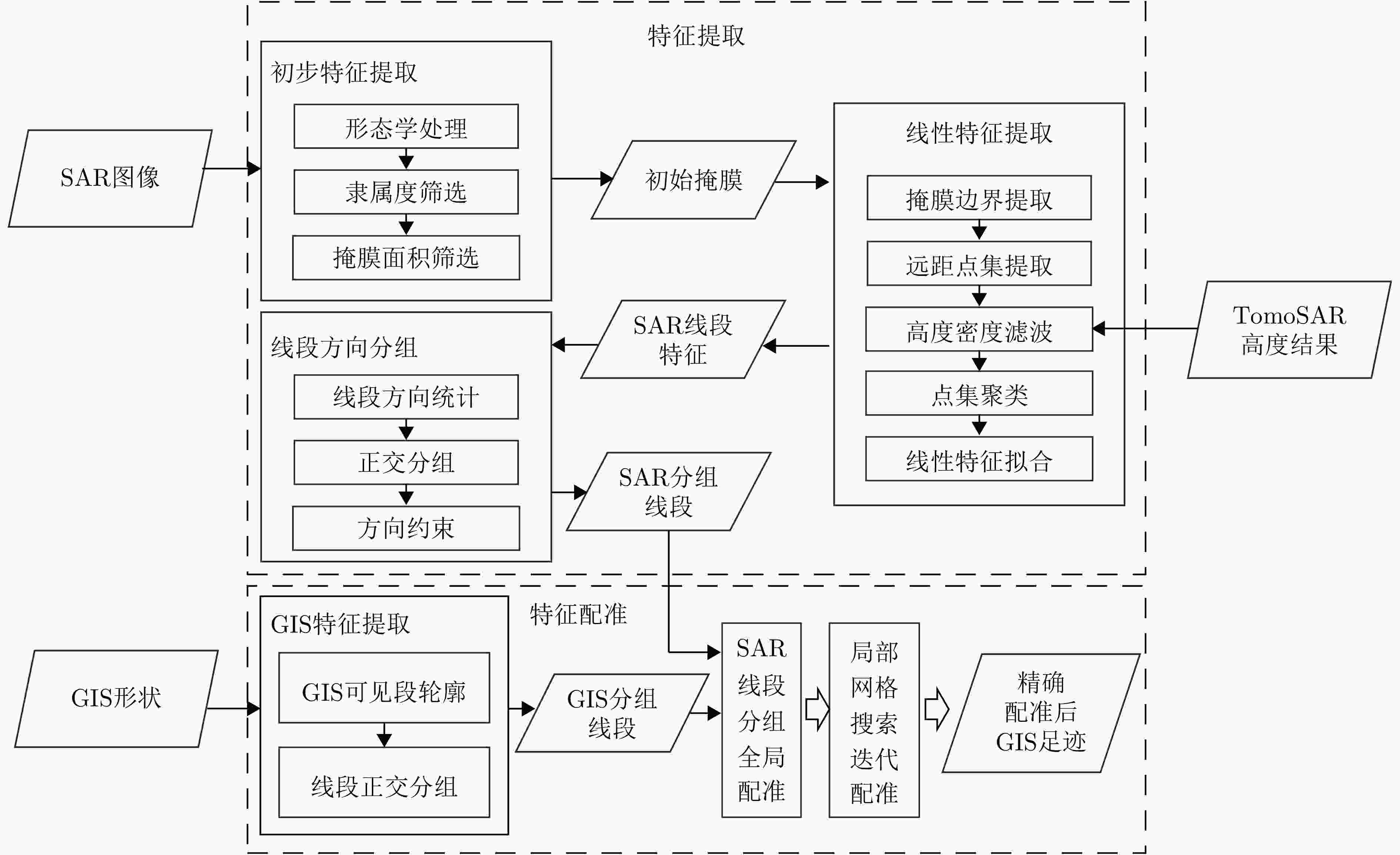
图 1 基于形态学指数的特征提取与配准框架流程图
Figure 1. Workflow of the feature extraction and registration framework based on morphological indices
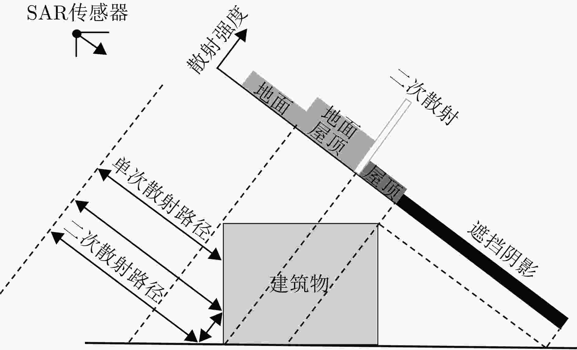
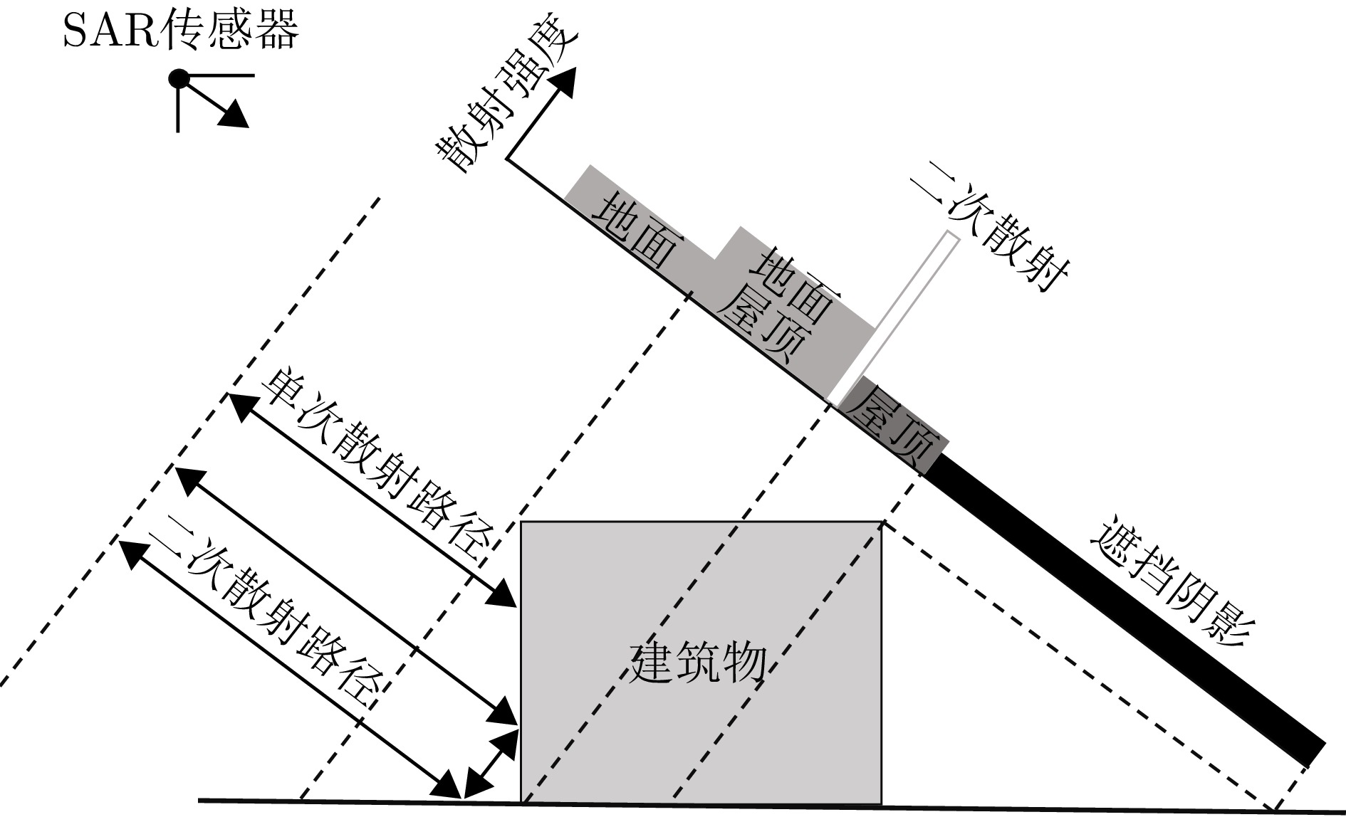
图 2 SAR影像中建筑散射区域与二次散射路径示意图
Figure 2. Schematic diagram of building scattering regions and double-bounce paths in SAR imagery
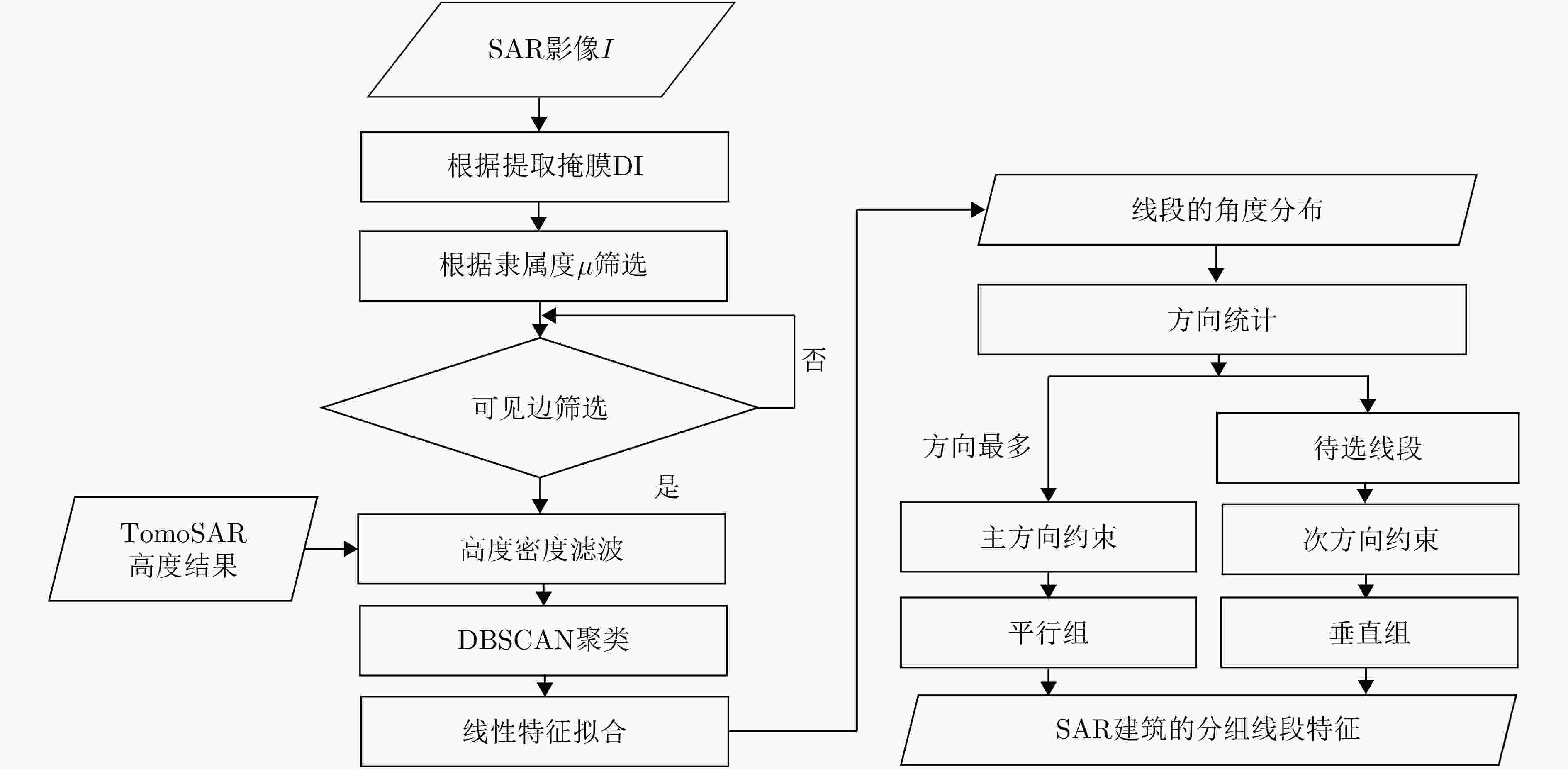
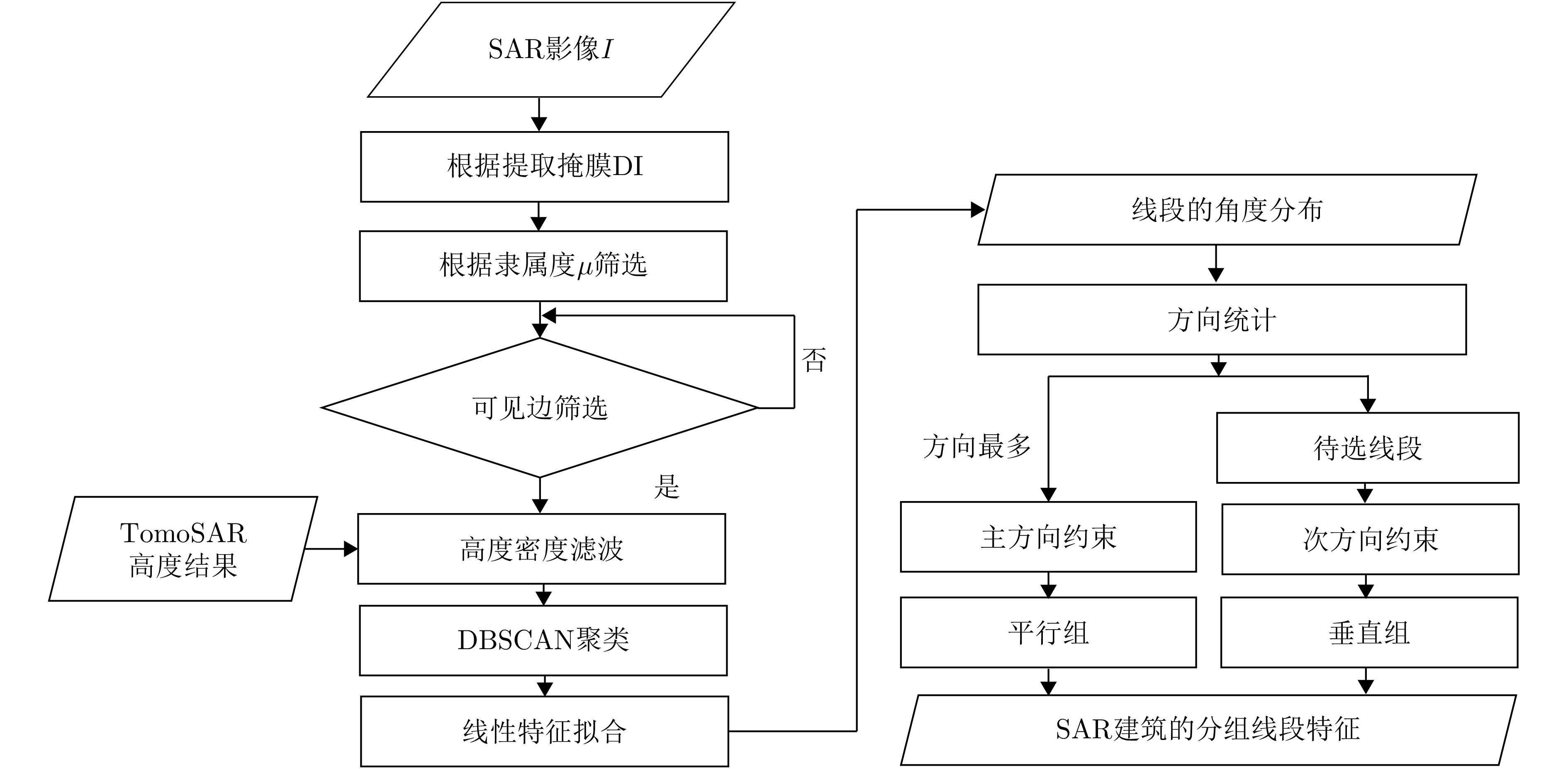
图 3 基于形态学指数与先验信息的特征提取算法流程图
Figure 3. Workflow of feature extraction algorithm based on morphological indices and prior information
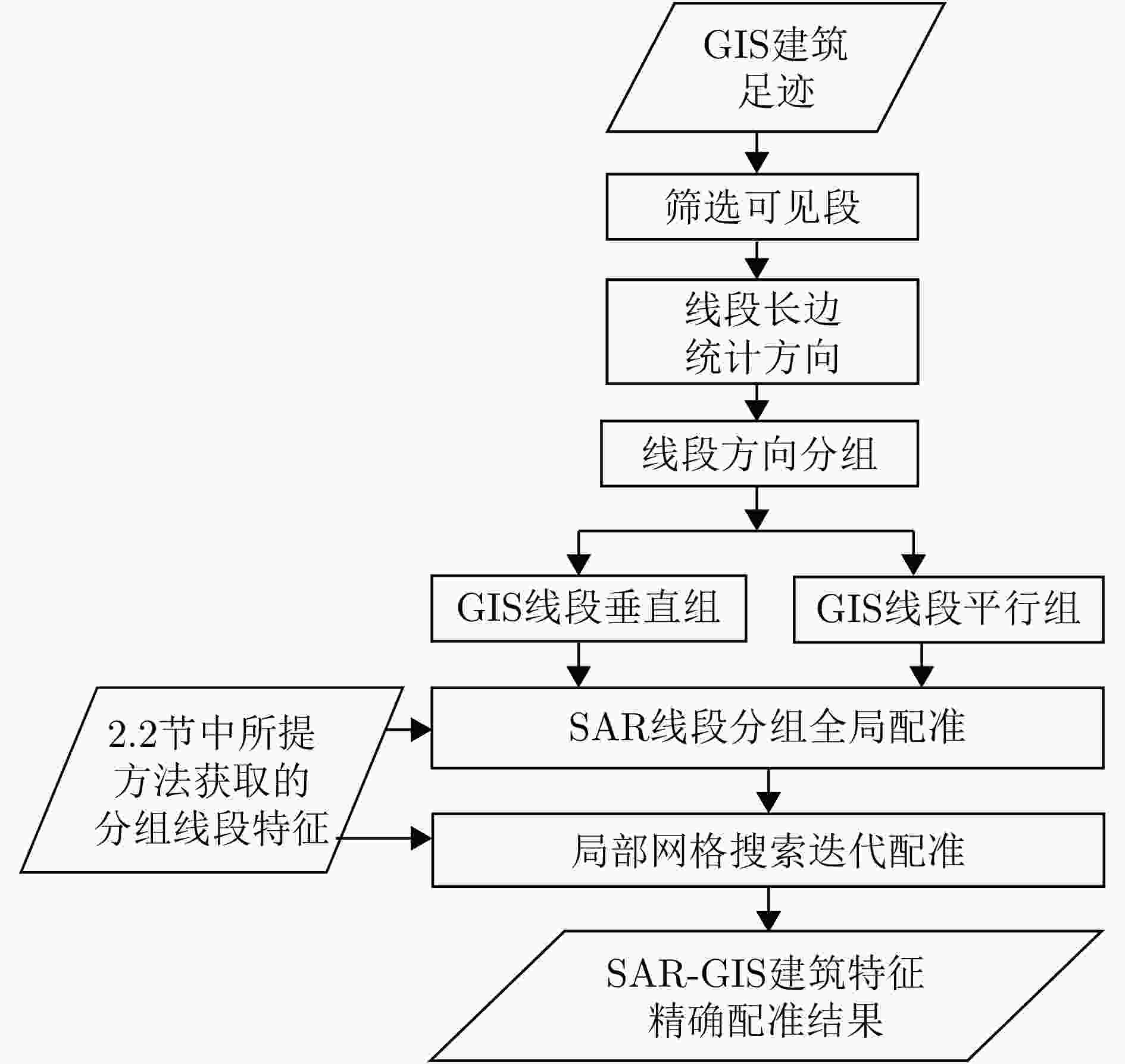
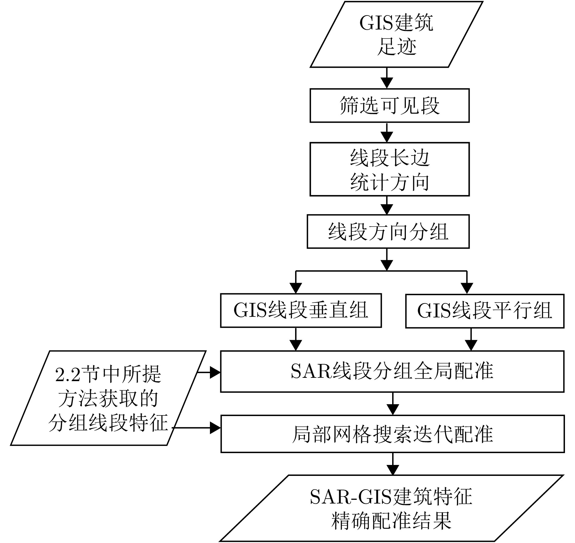
图 4 基于方向约束的网格化迭代配准方法流程图
Figure 4. Workflow of the gridded iterative registration method based on directional constraints
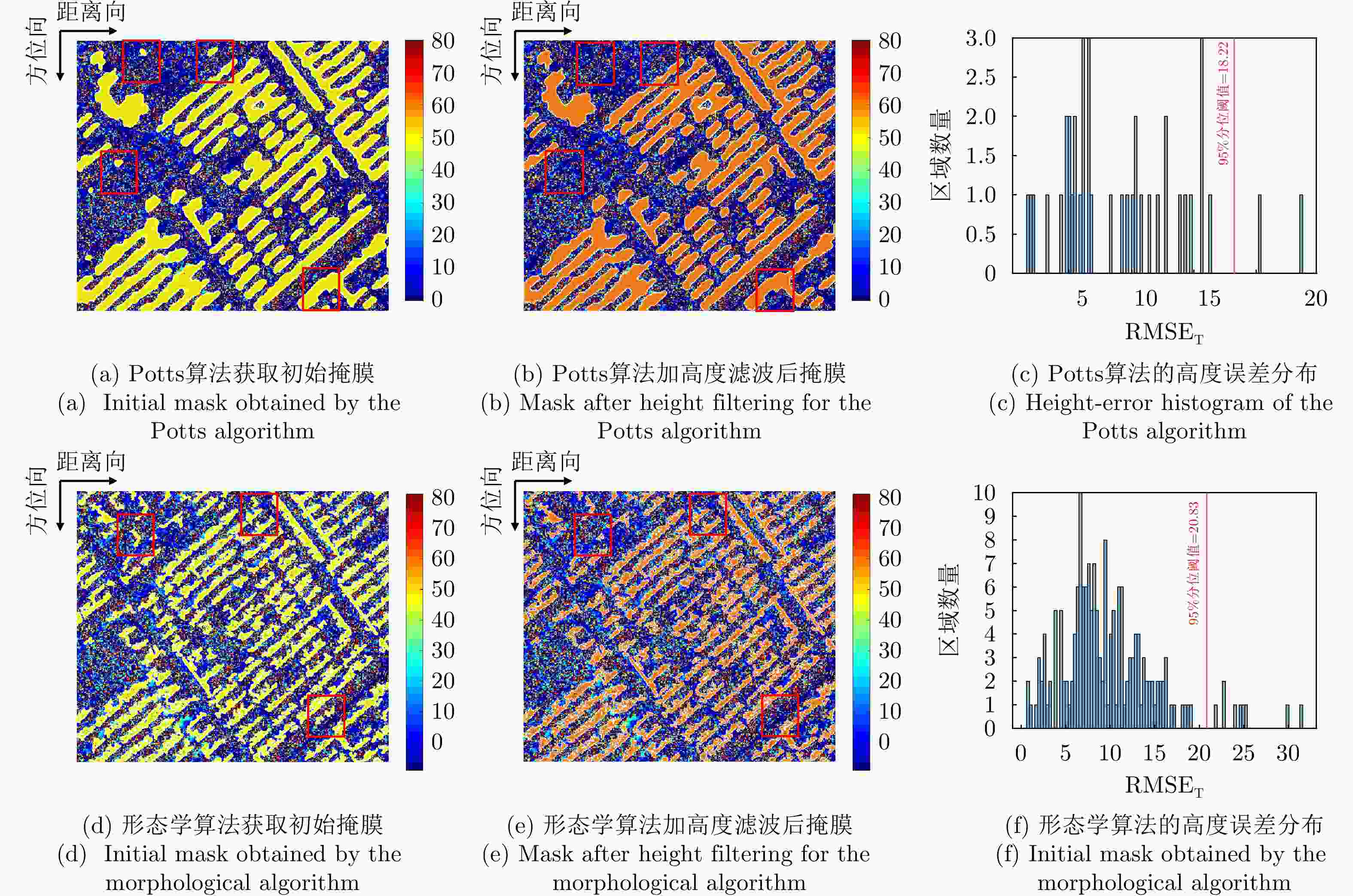
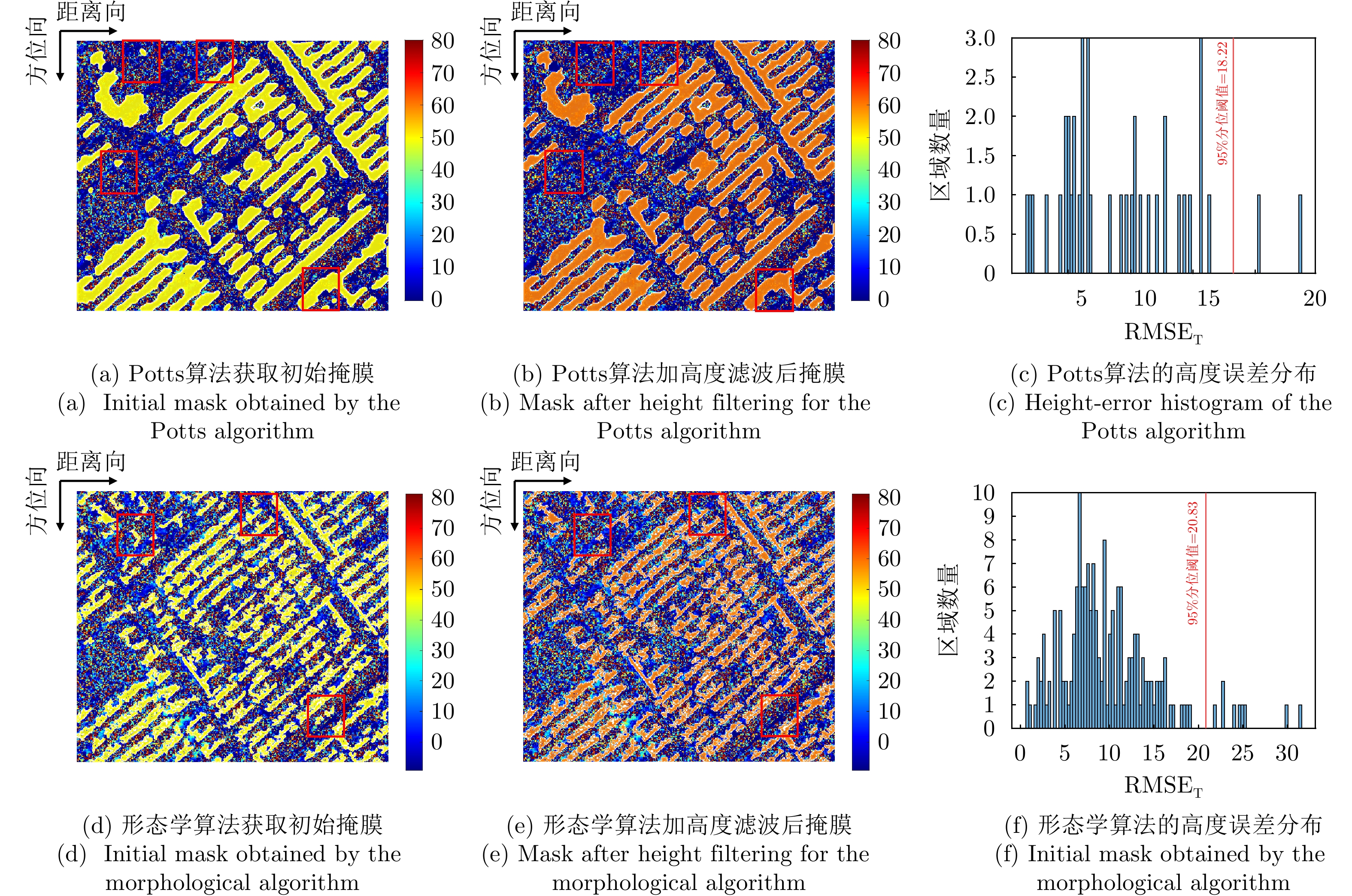
图 6 场景1不同算法经高度滤波后掩膜提取对比结果
Figure 6. Comparison of mask extraction results after height filtering for different algorithms in scene 1
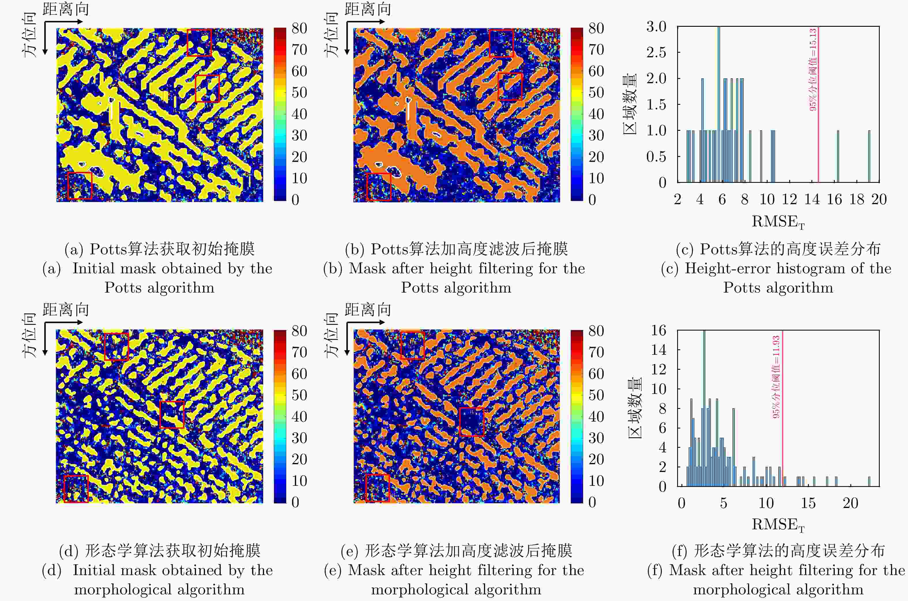
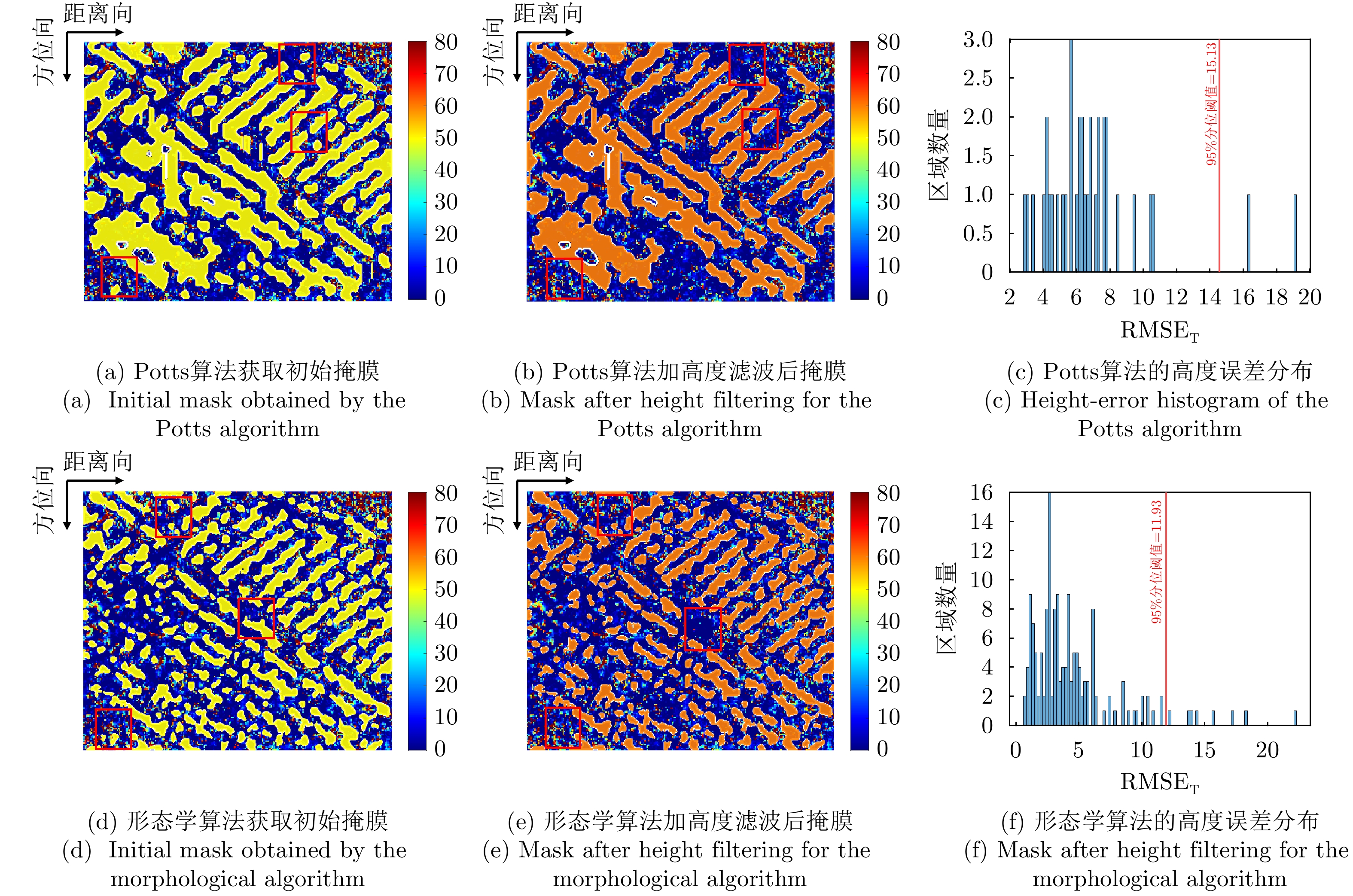
图 7 场景2不同算法经高度滤波后掩膜提取对比结果
Figure 7. Comparison of mask extraction results after height filtering for different algorithms in scene 2
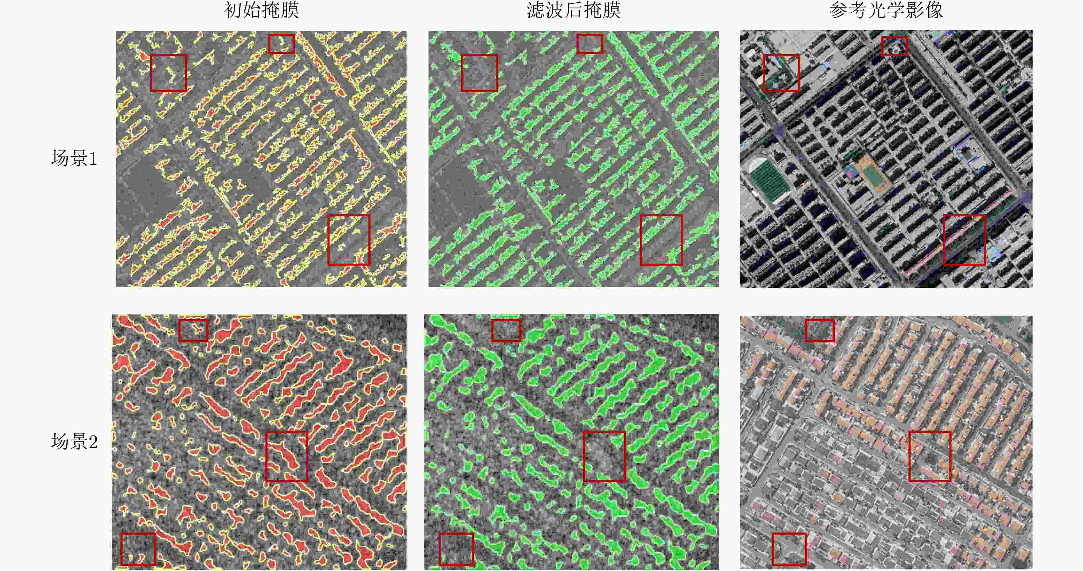
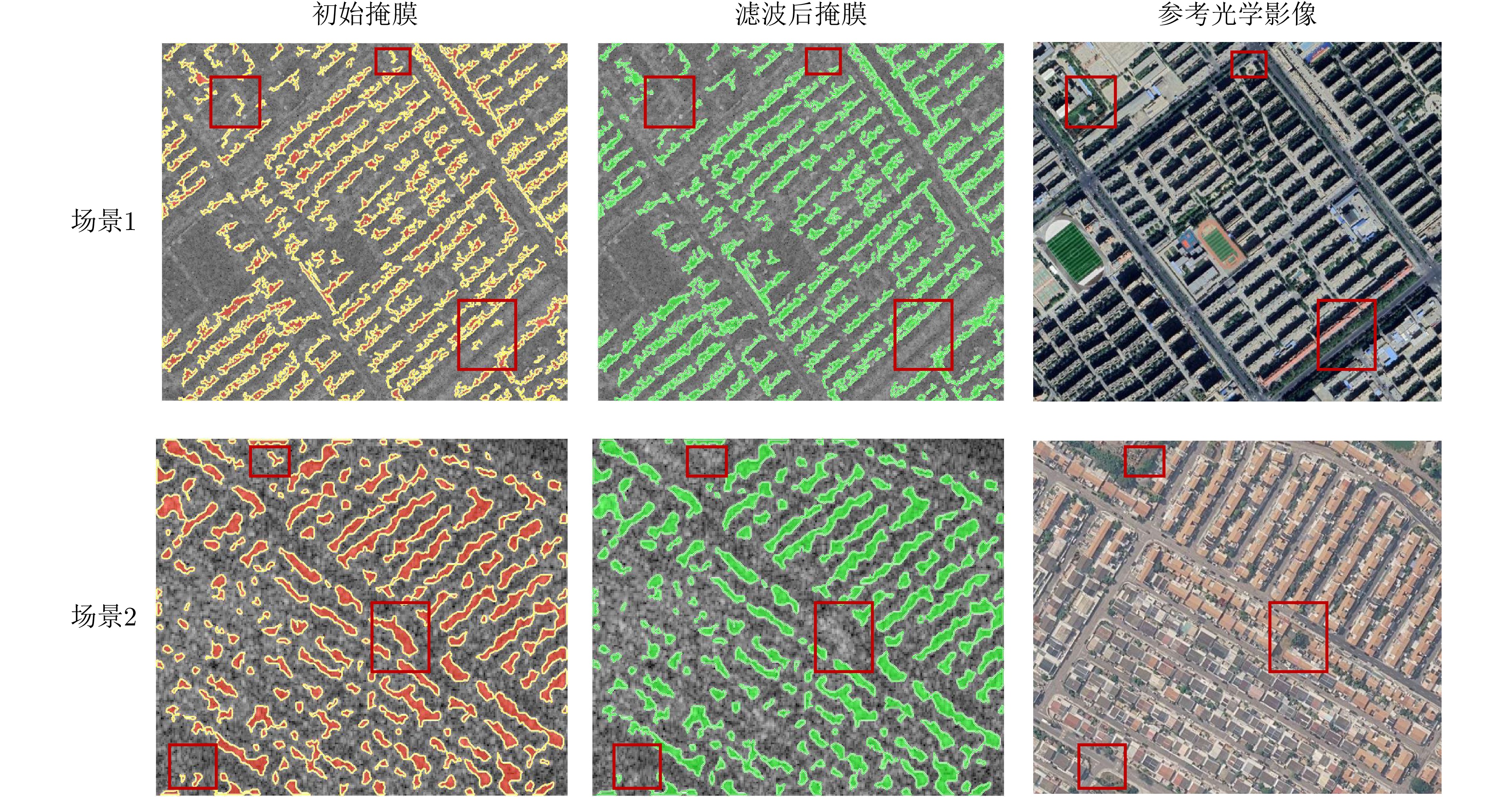
图 8 实验场景中高度滤波前后建筑掩膜与光学参考图的对比
Figure 8. Comparison of building masks before and after height filtering with optical reference images in the experimental scenes
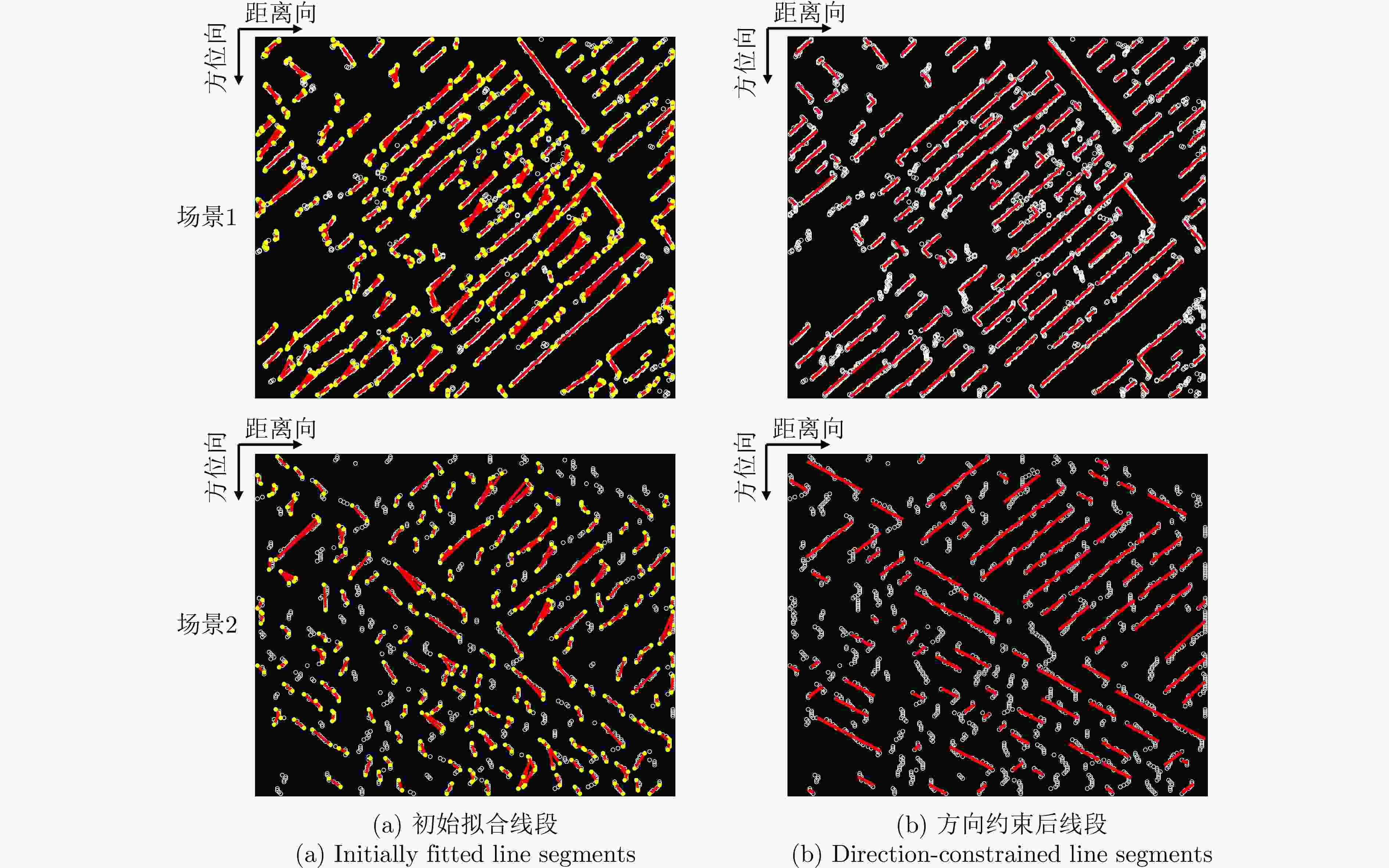
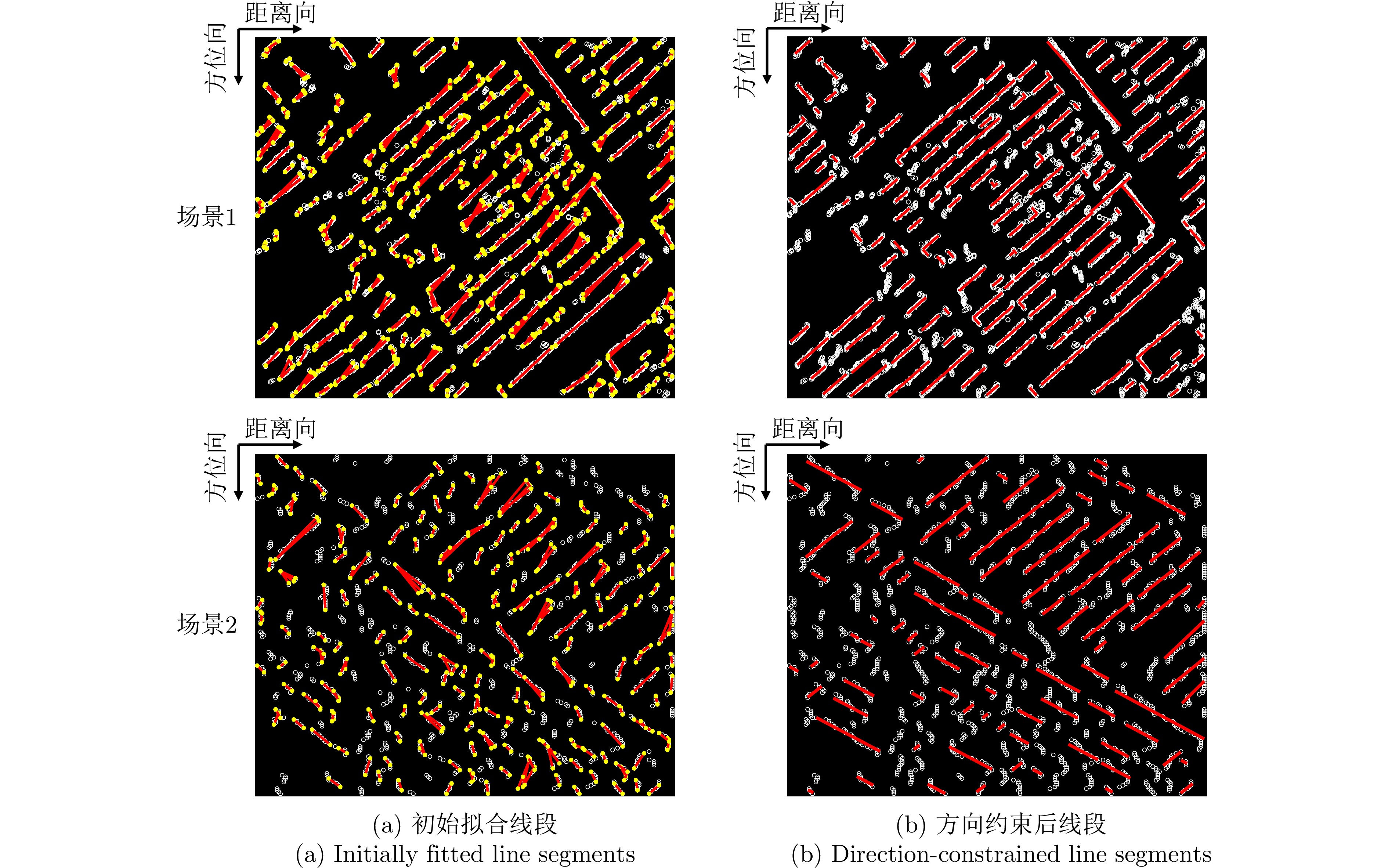
图 9 形态学算法经线段拟合与方向约束结果
Figure 9. Results of line segments fitting and directional-constraint based on the morphological method
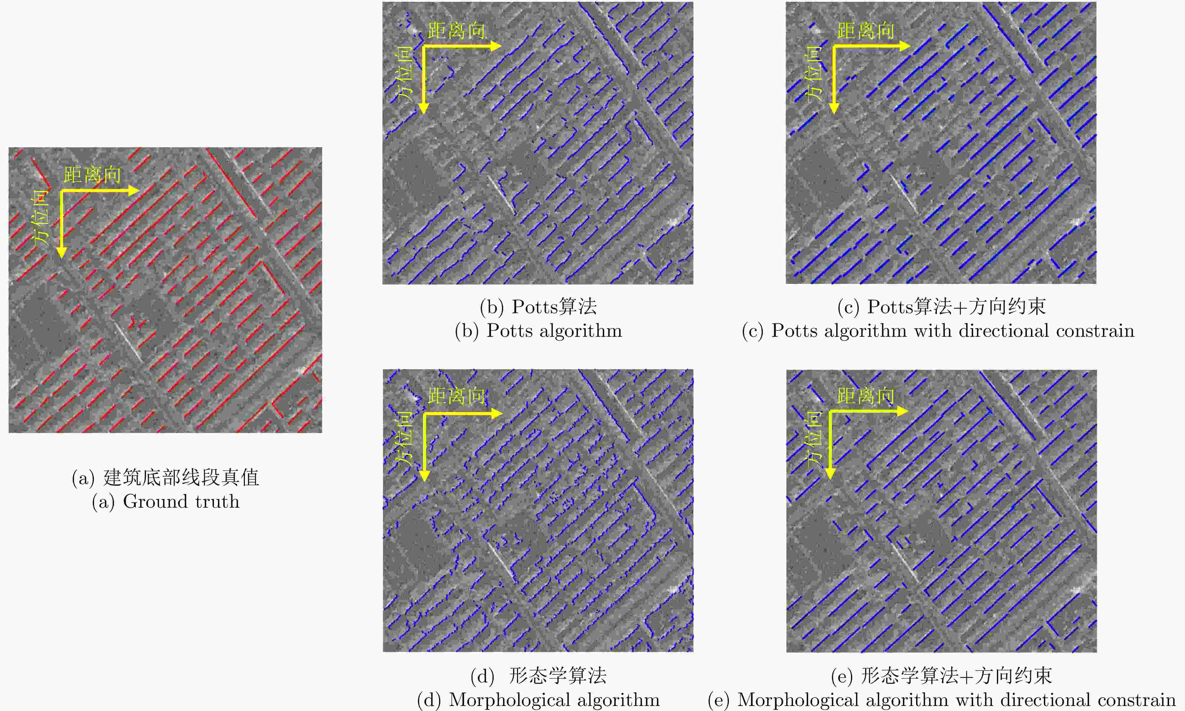
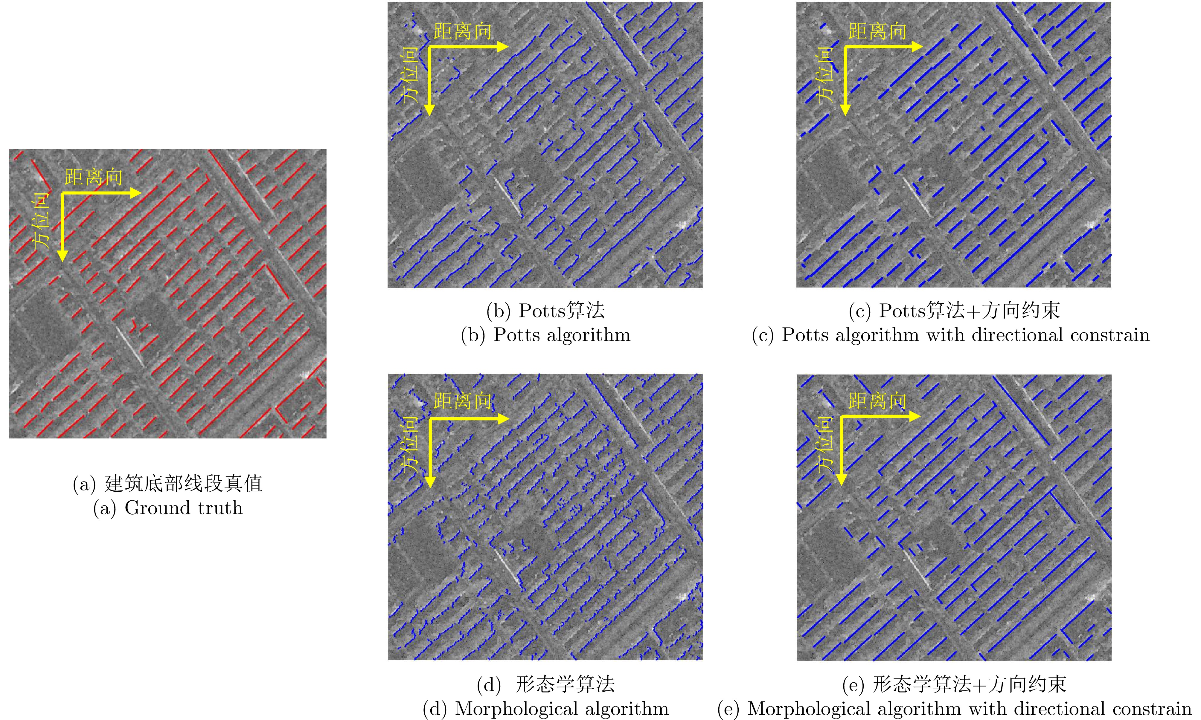
图 10 场景1中不同方法的建筑底部轮廓可见边提取结果对比
Figure 10. Comparison of visible building-base contour edges extracted by different methods in Scene 1
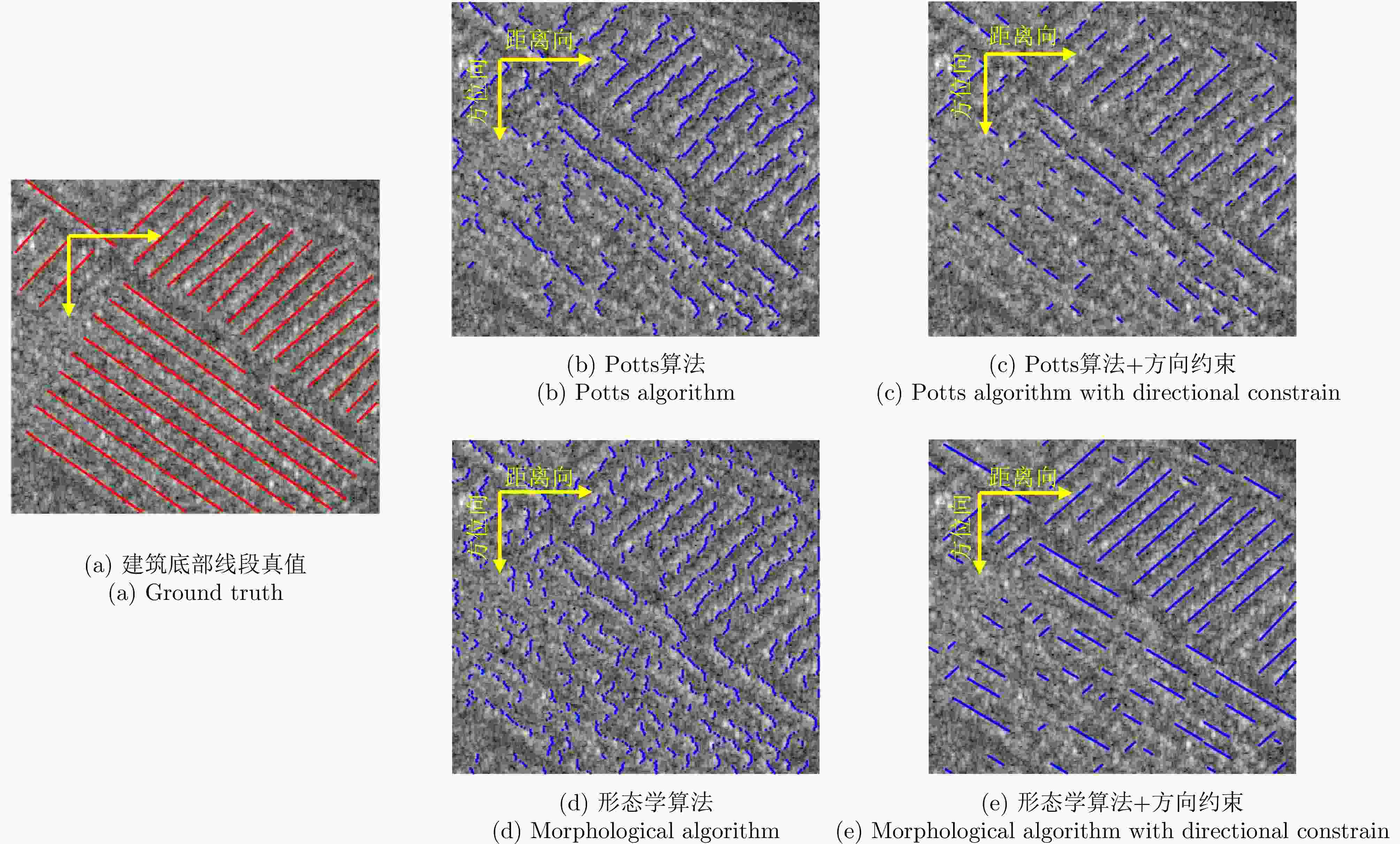
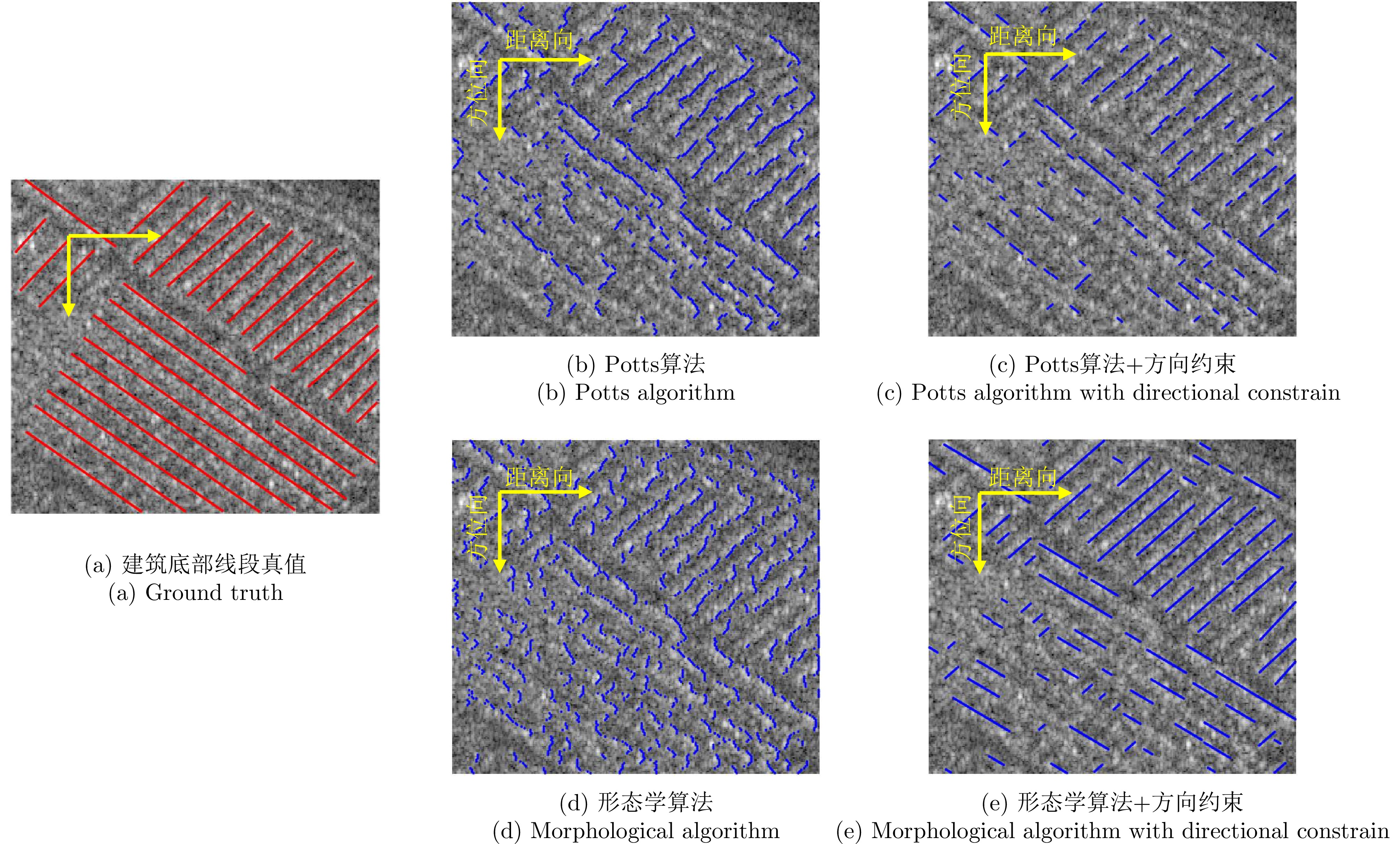
图 11 场景2中不同方法的建筑底部轮廓可见边提取结果对比
Figure 11. Comparison of visible building-base contour edges extracted by different methods in scene 2
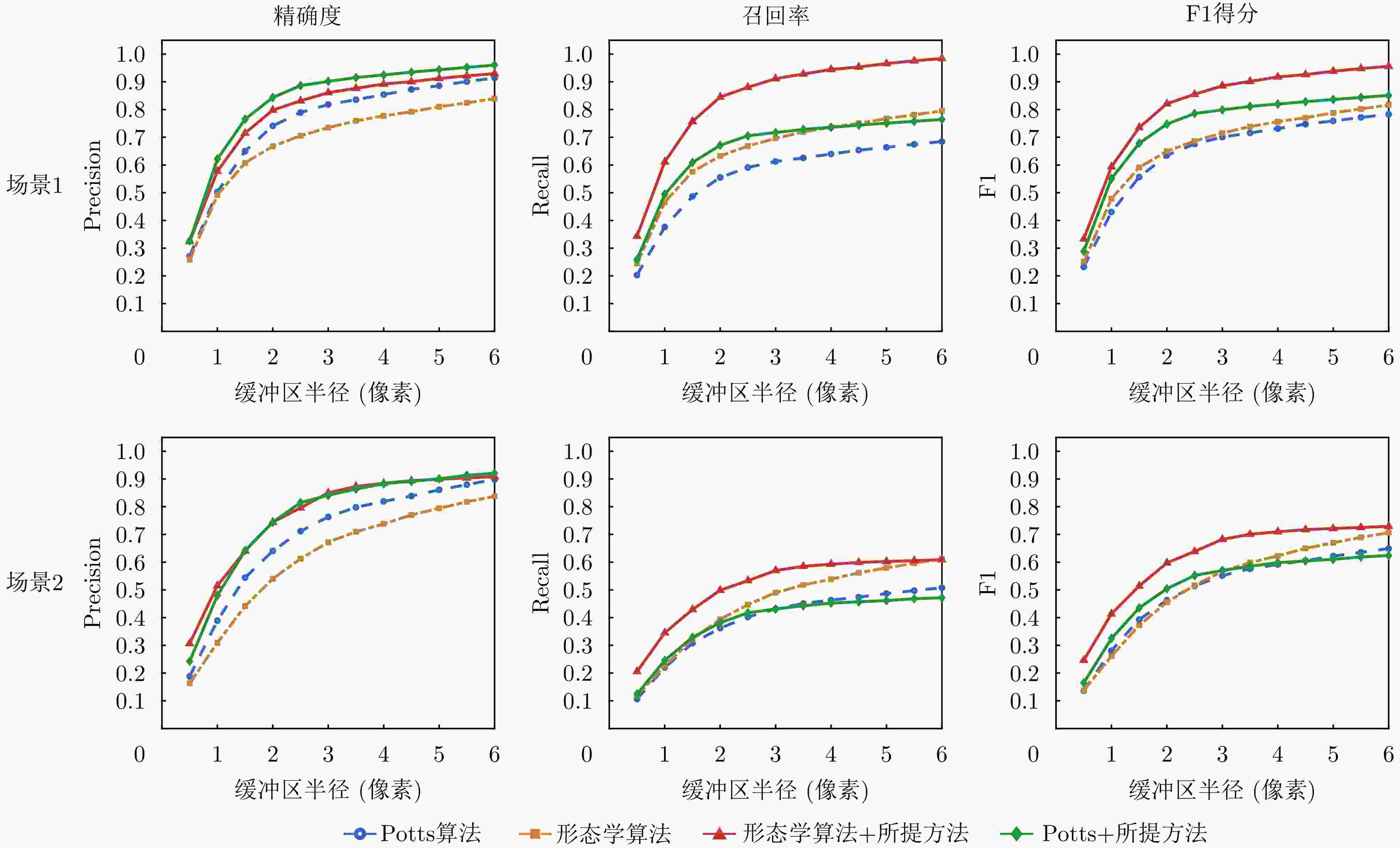
图 12 不同算法方向约束前后的点集提取精度对比
Figure 12. Evaluation of accuracy metrics for the extracted point sets
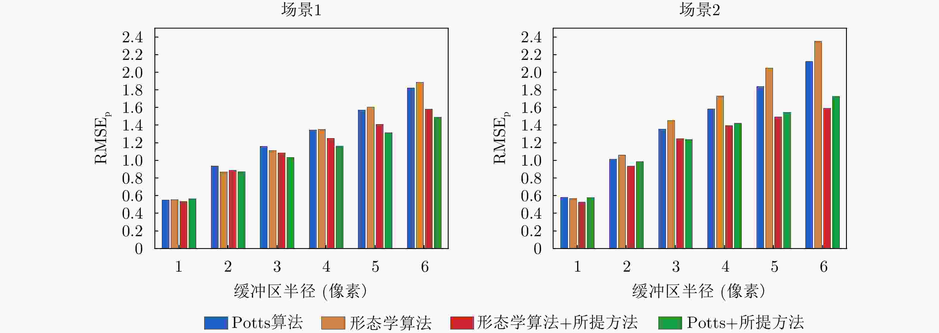
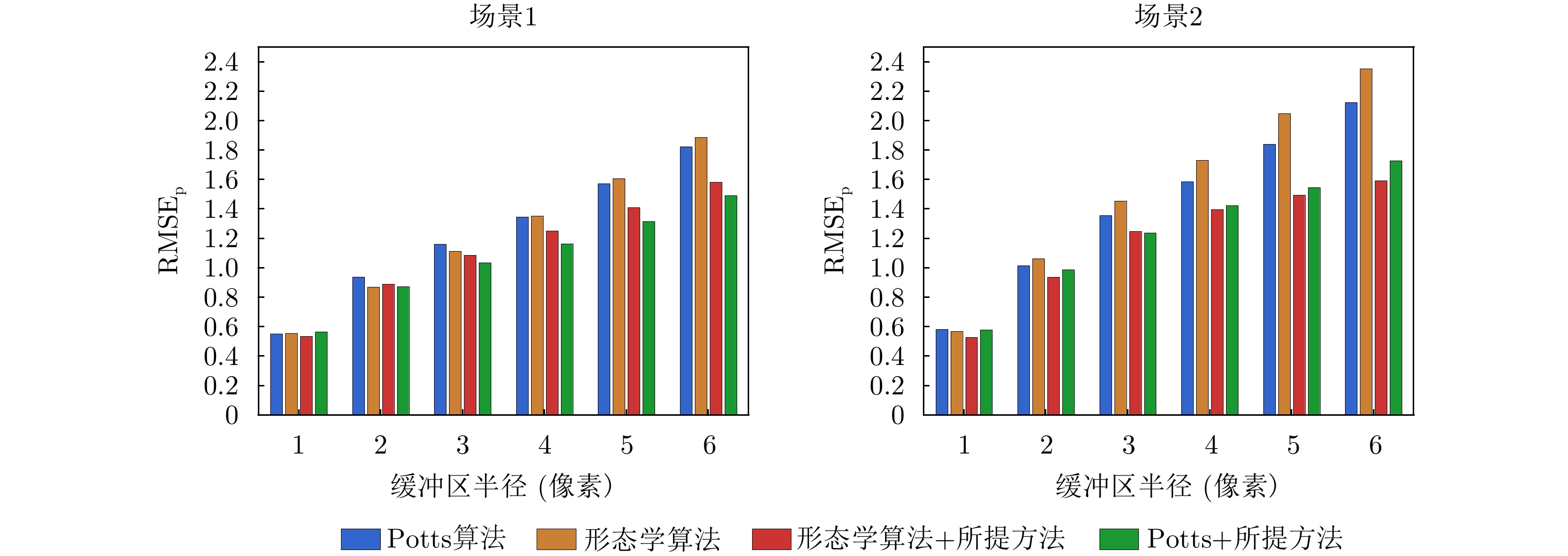
图 13 不同算法方向约束前后的均方根误差对比
Figure 13. Comparison of $ \mathrm{RMSE}_{\mathrm{p}} $ for point set extraction among different methods
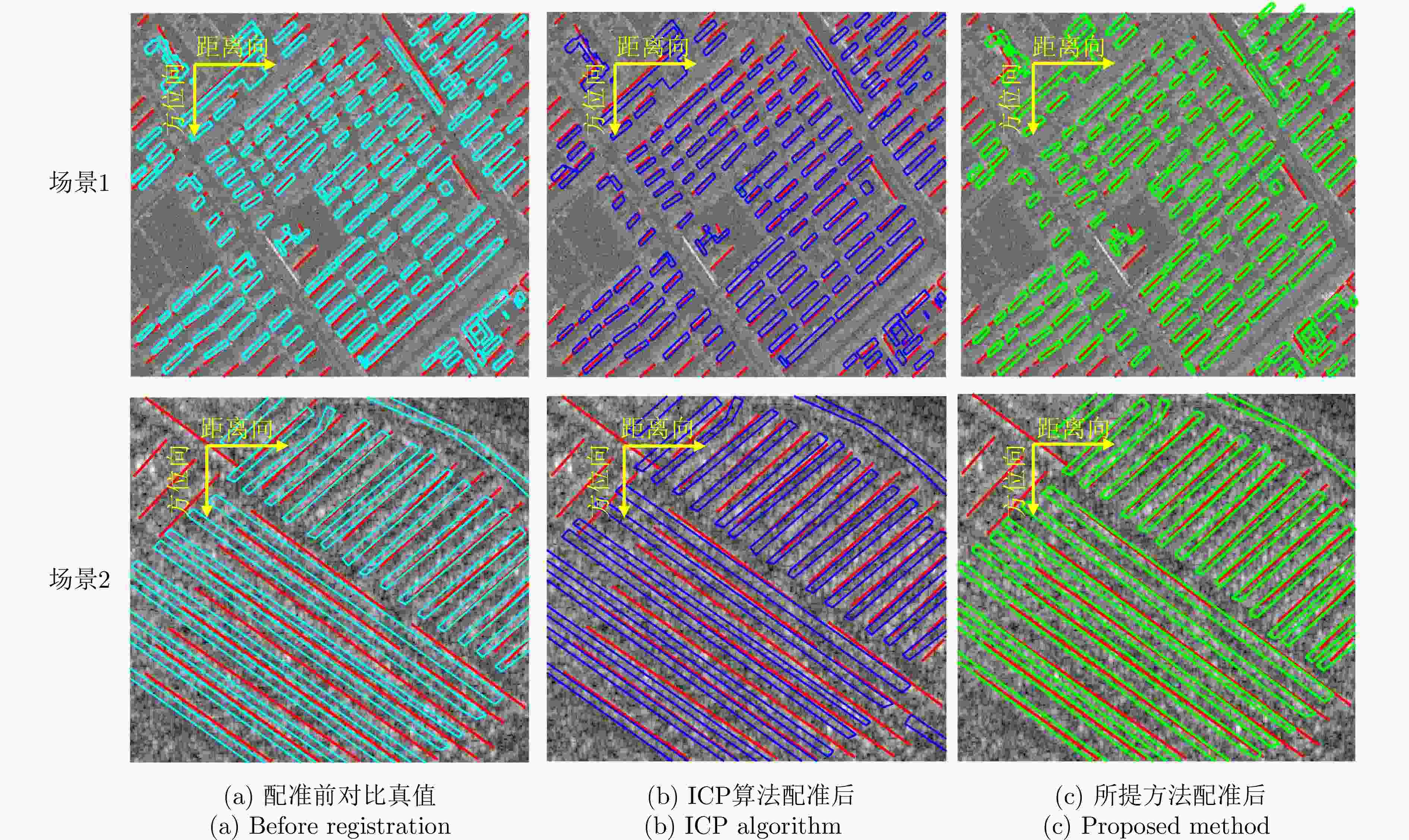
图 15 大场景配准前后完整足迹对比
Figure 15. Comparison of complete building footprints before and after registration
表 1 不同方法对比量化指标
Table 1. Quantitative comparison of different methods
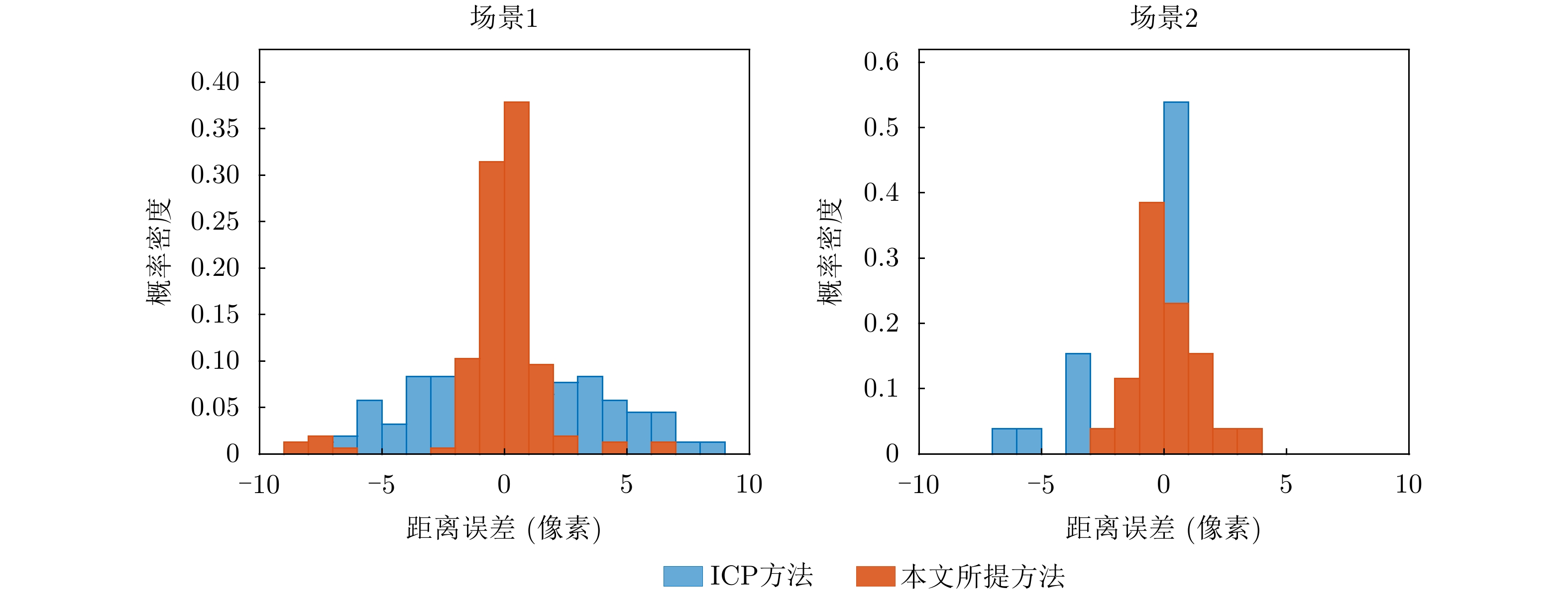
实验区域 方法 MAE (像素) RMSEreg (像素) STD (像素) CAR (%) 场景1 配准前 3.959 5.189 5.058 67.95 ICP配准方法 3.674 4.843 4.852 73.72 本文提出方法 1.378 3.071 3.080 92.95 场景2 配准前 1.822 2.779 2.795 61.54 ICP配准方法 1.537 2.375 2.175 69.23 本文提出方法 0.820 1.237 1.239 88.46  下载: 导出CSV
-
[1] MARCHESI S, BOVOLO F, and BRUZZONE L. A context-sensitive technique robust to registration noise for change detection in VHR multispectral images[J]. IEEE Transactions on Image Processing, 2010, 19(7): 1877–1889. doi: 10.1109/TIP.2010.2045070. [2] SOERGEL U, THOENNESSEN U, BRENNER A, et al. High-resolution SAR data: New opportunities and challenges for the analysis of urban areas[J]. IEE Proceedings-Radar, Sonar and Navigation, 2006, 153(3): 294–300. doi: 10.1049/ip-rsn:20045088. [3] FARQUHARSON G, CASTELLETTI D, DE S, et al. The new Capella space satellite generation: Acadia[C]. IEEE International Geoscience and Remote Sensing Symposium, Pasadena, USA, 2023: 1513–1516. doi: 10.1109/IGARSS52108.2023.10283030. [4] WANG Jili, LI Hongxiang, ZHANG Heng, et al. Demonstration of single-pass spaceborne multi-baseline InSAR result of Hongtu-1 constellation[C]. IEEE International Geoscience and Remote Sensing Symposium, Athens, Greece, 2024: 10881–10884. doi: 10.1109/IGARSS53475.2024.10642742. [5] BI Hui, JIN Shuang, XU Weihao, et al. First three-dimensional imaging experiment of Chinese commercial SAR satellite Fucheng-1[J]. Science China Information Sciences, 2025, 68(7): 177301. doi: 10.1007/s11432-024-4418-8. [6] BARRECA G, BONFORTE A, and NERI M. A pilot GIS database of active faults of Mt. Etna (Sicily): A tool for integrated hazard evaluation[J]. Journal of Volcanology and Geothermal Research, 2013, 251: 170–186. doi: 10.1016/j.jvolgeores.2012.08.013. [7] WEI Shunjun, ZHANG Xiaoling, and SHI Jun. Linear array SAR imaging via compressed sensing[J]. Progress in Electromagnetics Research, 2011, 117: 299–319. doi: 10.2528/PIER11033105. [8] SUN Yao, SHAHZAD M, and ZHU Xiaoxiang. Building height estimation in single SAR image using OSM building footprints[C]. 2017 Joint Urban Remote Sensing Event, Dubai, United Arab Emirates, 2017: 1–4. doi: 10.1109/JURSE.2017.7924549. [9] THIELE A, HINZ S, and CADARIO E. Combining GIS and InSAR data for 3D building reconstruction[C]. IEEE International Geoscience and Remote Sensing Symposium, Honolulu, USA, 2010: 2418–2421. doi: 10.1109/IGARSS.2010.5654387. [10] WU Fan, GONG Lixia, ZHANG Bo, et al. A review of urban building extraction from synthetic aperture radar imagery based on deep learning[J]. IEEE Access, 2025, 13: 137896–137918. doi: 10.1109/ACCESS.2025.3593955. [11] SHAHZAD M, MAURER M, FRAUNDORFER F, et al. Buildings detection in VHR SAR images using fully convolution neural networks[J]. IEEE Transactions on Geoscience and Remote Sensing, 2019, 57(2): 1100–1116. doi: 10.1109/TGRS.2018.2864716. [12] SUN Yao, HUA Yuansheng, MOU Lichao, et al. CG-Net: Conditional GIS-aware network for individual building segmentation in VHR SAR images[J]. IEEE Transactions on Geoscience and Remote Sensing, 2022, 60: 5201215. doi: 10.1109/TGRS.2020.3043089. [13] 康健, 王智睿, 祝若鑫, 等. 基于监督对比学习正则化的高分辨率SAR图像建筑物提取方法[J]. 雷达学报, 2022, 11(1): 157–167. doi: 10.12000/JR21124.KANG Jian, WANG Zhirui, ZHU Ruoxin, et al. Supervised contrastive learning regularized high-resolution synthetic aperture radar building footprint generation[J]. Journal of Radars, 2022, 11(1): 157–167. doi: 10.12000/JR21124. [14] 田野, 丁赤飚, 张福博, 等. 一种基于深度学习的SAR城市建筑区域叠掩精确检测方法[J]. 雷达学报, 2023, 12(2): 441–455. doi: 10.12000/JR23033.TIAN Ye, DING Chibiao, ZHANG Fubo, et al. SAR building area layover detection based on deep learning[J]. Journal of Radars, 2023, 12(2): 441–455. doi: 10.12000/JR23033. [15] WANG Mengyu, YAN Zhiyuan, DIAO Wenhui, et al. VCINet: Visual cue-inspired feature learning network for SAR building segmentation[J]. IEEE Journal of Selected Topics in Applied Earth Observations and Remote Sensing, 2025, 18: 15551–15567. doi: 10.1109/JSTARS.2025.3579753. [16] ZHANG Fengli, SHAO Yun, ZHANG Xiao, et al. Building L-shape footprint extraction from high resolution SAR image[C]. 2011 Joint Urban Remote Sensing Event, Munich, Germany, 2011: 273–276. doi: 10.1109/JURSE.2011.5764772. [17] FERRO A, BRUNNER D, and BRUZZONE L. Automatic detection and reconstruction of building radar footprints from single VHR SAR images[J]. IEEE Transactions on Geoscience and Remote Sensing, 2013, 51(2): 935–952. doi: 10.1109/tgrs.2012.2205156. [18] 张子源. SAR图像建筑物检测方法研究及应用[D]. [硕士论文], 西安电子科技大学, 2017: 1–100.ZHANG Ziyuan. SAR building detection research and application[D]. [Master dissertation], Xidian University, 2017: 1–100. [19] LIU Qi, LI Qiang, YU Weidong, et al. Automatic building detection for multi-aspect SAR images based on the variation features[J]. Remote Sensing, 2022, 14(6): 1409. doi: 10.3390/rs14061409. [20] CUI L P, WANG X P, DOU A X, et al. High resolution SAR imaging employing geometric features for extracting seismic damage of buildings[J]. The International Archives of the Photogrammetry, Remote Sensing and Spatial Information Sciences, 2018, XLII-3: 239–244. doi: 10.5194/isprs-archives-xlii-3-239-2018. [21] CHO K, PARK S E, CHO J H, et al. Automatic urban area extraction from SAR image based on morphological operator[J]. IEEE Geoscience and Remote Sensing Letters, 2021, 18(5): 831–835. doi: 10.1109/lgrs.2020.2989461. [22] AMJADIPOUR F, GHASSEMIAN H, and IMANI M. Building detection using very high resolution SAR images with multi-direction based on weighted-morphological indexes[C]. 2022 International Conference on Machine Vision and Image Processing, Ahvaz, Islamic Republic of Iran, 2022: 1–6. doi: 10.1109/MVIP53647.2022.9738776. [23] 王伟, 许华荣, 魏含玉, 等. 面向阵列InSAR点云规则化的渐近式建筑立面检测[J]. 雷达学报, 2022, 11(1): 144–156. doi: 10.12000/JR21177.WANG Wei, XU Huarong, WEI Hanyu, et al. Progressive building facade detection for regularizing array InSAR point clouds[J]. Journal of Radars, 2022, 11(1): 144–156. doi: 10.12000/JR21177. [24] SUN Yao, WANG Yuanyuan, and ZHU Xiaoxiang. Automatic registration of SAR image and GIS building footprints data in dense urban area[C]. IEEE International Geoscience and Remote Sensing Symposium, Yokohama, Japan, 2019: 927–930. doi: 10.1109/IGARSS.2019.8900187. [25] SUN Yao, MONTAZERI S, WANG Yuanyuan, et al. Automatic registration of a single SAR image and GIS building footprints in a large-scale urban area[J]. ISPRS Journal of Photogrammetry and Remote Sensing, 2020, 170: 1–14. doi: 10.1016/j.isprsjprs.2020.09.016. [26] AUER S and GERNHARDT S. Linear signatures in urban SAR images—Partly misinterpreted?[J]. IEEE Geoscience and Remote Sensing Letters, 2014, 11(10): 1762–1766. doi: 10.1109/LGRS.2014.2308353. [27] STORATH M, WEINMANN A, and UNSER M. Unsupervised texture segmentation using monogenic curvelets and the Potts model[C]. IEEE International Conference on Image Processing, Paris, France, 2014: 4348–4352. doi: 10.1109/ICIP.2014.7025883. [28] STORATH M, WEINMANN A, FRIKEL J, et al. Joint image reconstruction and segmentation using the Potts model[J]. Inverse Problems, 2015, 31(2): 025003. doi: 10.1088/0266-5611/31/2/025003. -





计量
- 文章访问数:
- HTML全文浏览量:
- PDF下载量:
- 被引次数: 0