
 Submit Manuscript
 Peer Review
 Editor Work
- Home
- Articles & Issues
-
Data
- Dataset of Radar Detecting Sea
- SAR Dataset
- SARGroundObjectsTypes
- SARMV3D
- AIRSAT Constellation SAR Land Cover Classification Dataset
- 3DRIED
- UWB-HA4D
- LLS-LFMCWR
- FAIR-CSAR
- MSAR
- SDD-SAR
- FUSAR
- SpaceborneSAR3Dimaging
- Sea-land Segmentation
- SAR Multi-domain Ship Detection Dataset
- SAR-Airport
- Hilly and mountainous farmland time-series SAR and ground quadrat dataset
- SAR images for interference detection and suppression
- HP-SAR Evaluation & Analytical Dataset
- GDHuiYan-ATRNet
- Multi-System Maritime Low Observable Target Dataset
- DatasetinthePaper
- DatasetintheCompetition
- Report
- Course
- About
- Publish
- Editorial Board
- Chinese
| Citation: | ZENG Guobing, XU Huaping, WANG Yuan, et al. Demonstration of spaceborne multi-static SAR tomography and forest height estimation[J]. Journal of Radars, 2026, 15(1): 107–119. doi: 10.12000/JR25269

|
Demonstration of Spaceborne Multi-static SAR Tomography and Forest Height Estimation
DOI: 10.12000/JR25269 CSTR: 32380.14.JR25269
More Information-
Abstract
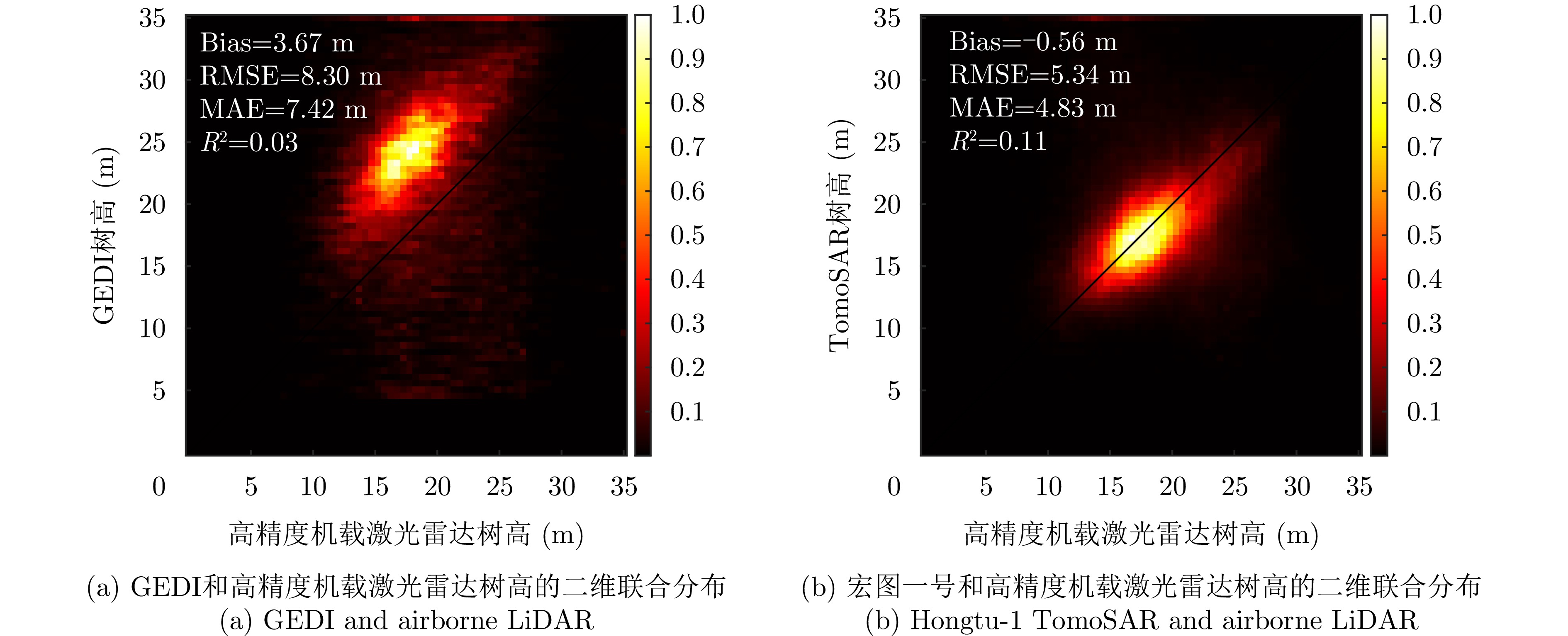
Synthetic Aperture Radar Tomography (TomoSAR), by virtue of its three-dimensional (3D) resolution capability, can be used to study the 3D structure of semitransparent targets, such as forests, icebergs, and snowpacks. Currently, TomoSAR measurements, especially spaceborne TomoSAR, are mostly obtained through repeat-pass observations, which introduce two major problems: Temporal decorrelation and signal delay caused by the troposphere or ionosphere. Severe temporal decorrelation and signal delay can lead to defocused tomograms, which make it impossible to reconstruct the 3D structure of a target. Unlike repeat-pass TomoSAR systems, multi-static TomoSAR systems simultaneously collect multibaseline images, reducing temporal decorrelation to zero and canceling all types of signal delay, making them an ideal tool for 3D TomoSAR reconstruction. The Hongtu-1 constellation, launched in 2023 and operated by PIESAT Information Technology Limited, is the world’s first spaceborne multi-static SAR system. In this paper, we conduct spaceborne multi-static TomoSAR processing and forest height estimation experiments using Hongtu-1 multi-static images. By comparing tomograms from tropical and temperate forests, it is found that the X-band signal from Hongtu-1 cannot reach the ground in dense tropical forests, but can in temperate forests, due to much lower tree and leaf density. This indicates that Hongtu-1 is capable of forest height measurement in temperate forests. By comparing forest height inversion in temperate forests obtained from Hongtu-1 TomoSAR and GEDI LiDAR, it is found that, at the test sites considered in this paper, Hongtu-1 TomoSAR measurements can provide more accurate forest height inversion (with a 35% improvement), more measurement points, and higher-resolution products than GEDI, which further demonstrates the capability and superiority of Hongtu-1 TomoSAR in forest height estimation. -

-
References
[1] PAN Yude, BIRDSEY R A, FANG Jingyun, et al. A large and persistent carbon sink in the world’s forests[J]. Science, 2011, 333(6045): 988–993. doi: 10.1126/science.1201609.[2] PAN Yude, BIRDSEY R A, PHILLIPS O L, et al. The enduring world forest carbon sink[J]. Nature, 2024, 631(8021): 563–569. doi: 10.1038/s41586-024-07602-x.[3] DUBAYAH R, ARMSTON J, HEALEY S P, et al. GEDI launches a new era of biomass inference from space[J]. Environmental Research Letters, 2022, 17(9): 095001. doi: 10.1088/1748-9326/ac8694.[4] DUNCANSON L, KELLNER J R, ARMSTON J, et al. Aboveground biomass density models for NASA’s Global Ecosystem Dynamics Investigation (GEDI) Lidar mission[J]. Remote Sensing of Environment, 2022, 270: 112845. doi: 10.1016/j.rse.2021.112845.[5] SCHUTZ B E, ZWALLY H J, SHUMAN C A, et al. Overview of the ICESat mission[J]. Geophysical Research Letters, 2005, 32(21): L21S01. doi: 10.1029/2005GL024009.[6] ABDALATI W, ZWALLY H J, BINDSCHADLER R, et al. The ICESat-2 laser altimetry mission[J]. Proceedings of the IEEE, 2010, 98(5): 735–751. doi: 10.1109/JPROC.2009.2034765.[7] 李震, 张平, 乔海伟, 等. 层析SAR地表参数信息提取研究进展[J]. 雷达学报, 2021, 10(1): 116–130. doi: 10.12000/JR20095.LI Zhen, ZHANG Ping, QIAO Haiwei, et al. Advances in information extraction of surface parameters using Tomographic SAR[J]. Journal of Radars, 2021, 10(1): 116–130. doi: 10.12000/JR20095.[8] 丁赤飚, 仇晓兰, 徐丰, 等. 合成孔径雷达三维成像—从层析、阵列到微波视觉[J]. 雷达学报, 2019, 8(6): 693–709. doi: 10.12000/JR19090.DING Chibiao, QIU Xiaolan, XU Feng, et al. Synthetic aperture radar three-dimensional imaging—from TomoSAR and array InSAR to microwave vision[J]. Journal of Radars, 2019, 8(6): 693–709. doi: 10.12000/JR19090.[9] LE TOAN T, QUEGAN S, DAVIDSON M W J, et al. The BIOMASS mission: Mapping global forest biomass to better understand the terrestrial carbon cycle[J]. Remote Sensing of Environment, 2011, 115(11): 2850–2860. doi: 10.1016/j.rse.2011.03.020.[10] QUEGAN S, LE TOAN T, CHAVE J, et al. The European Space Agency BIOMASS mission: Measuring forest above-ground biomass from space[J]. Remote Sensing of Environment, 2019, 227: 44–60. doi: 10.1016/j.rse.2019.03.032.[11] HAJNSEK I, SCHEIBER R, KELLER M, et al. BIOSAR 2008: Final report[R]. 22052/08/NL/CT-002, 2009.[12] DUBOIS-FERNANDEZ P C, LE TOAN T, DANIEL S, et al. The TropiSAR airborne campaign in French Guiana: Objectives, description, and observed temporal behavior of the backscatter signal[J]. IEEE Transactions on Geoscience and Remote Sensing, 2012, 50(8): 3228–3241. doi: 10.1109/TGRS.2011.2180728.[13] HAJNSEK I, PARDINI M, HORN R, et al. SAR imaging of tropical African forests with P-band multibaseline acquisitions: Results from the AfriSAR campaign[C]. 2016 IEEE International Geoscience and Remote Sensing Symposium (IGARSS), Beijing, China, 2016: 7521–7523. doi: 10.1109/IGARSS.2016.7730961.[14] HAJNSEK I, PARDINI M, GULIAEV R, et al. Mapping tropical forest in Gabon with L-/P-band multibaseline acquisitions: First results from the GabonX campaign[C]. ESA POLinSAR Workshop, Toulouse, France, 2023.[15] KHATI U, LAVALLE M, and SINGH G. Spaceborne tomography of multi-species Indian tropical forests[J]. Remote Sensing of Environment, 2019, 229: 193–212. doi: 10.1016/j.rse.2019.04.017.[16] AGHABABAEE H, FORNARO G, and SCHIRINZI G. Phase calibration based on phase derivative constrained optimization in multibaseline SAR tomography[J]. IEEE Transactions on Geoscience and Remote Sensing, 2018, 56(11): 6779–6791. doi: 10.1109/TGRS.2018.2843447.[17] BRCIC R, PARIZZI A, EINEDER M, et al. Estimation and compensation of ionospheric delay for SAR interferometry[C]. 2010 IEEE International Geoscience and Remote Sensing Symposium, Honolulu, USA, 2010: 2908–2911. doi: 10.1109/IGARSS.2010.5652231.[18] MEYER F J. Performance requirements for ionospheric correction of low-frequency SAR data[J]. IEEE Transactions on Geoscience and Remote Sensing, 2011, 49(10): 3694–3702. doi: 10.1109/TGRS.2011.2146786.[19] KRIEGER G. MIMO-SAR: Opportunities and pitfalls[J]. IEEE Transactions on Geoscience and Remote Sensing, 2014, 52(5): 2628–2645. doi: 10.1109/TGRS.2013.2263934.[20] TEBALDINI S, MANZONI M, FERRO-FAMIL L, et al. FDM MIMO spaceborne SAR tomography by minimum redundancy wavenumber illumination[J]. IEEE Transactions on Geoscience and Remote Sensing, 2024, 62: 5207119. doi: 10.1109/TGRS.2024.3371267.[21] MITTERMAYER J, KRIEGER G, BOJARSKI A, et al. MirrorSAR: An HRWS add-on for single-pass multi-baseline SAR interferometry[J]. IEEE Transactions on Geoscience and Remote Sensing, 2022, 60: 5224018. doi: 10.1109/TGRS.2021.3132384.[22] LÓPEZ-DEKKER P, BIGGS J, CHAPRON B, et al. The Harmony mission: End of phase-0 science overview[C]. 2021 IEEE International Geoscience and Remote Sensing Symposium IGARSS, Brussels, Belgium, 2021: 7752–7755. doi: 10.1109/IGARSS47720.2021.9554896.[23] DENG Yunkai, ZHANG Heng, LIU Kaiyu, et al. Hongtu-1: The first spaceborne single-pass multibaseline SAR interferometry mission[J]. IEEE Transactions on Geoscience and Remote Sensing, 2025, 63: 5202518. doi: 10.1109/TGRS.2024.3523299.[24] ZENG Guobing, XU Huaping, WANG Yuan, et al. A novel method for airborne SAR tomography baseline error correction driven by small baseline interferometric phase[J]. IEEE Transactions on Geoscience and Remote Sensing, 2024, 62: 5225013. doi: 10.1109/TGRS.2024.3478055.[25] REIGBER A and MOREIRA A. First demonstration of airborne SAR tomography using multibaseline L-band data[J]. IEEE Transactions on Geoscience and Remote Sensing, 2000, 38(5): 2142–2152. doi: 10.1109/36.868873.[26] FORNARO G, LOMBARDINI F, and SERAFINO F. Three-dimensional multipass SAR focusing: Experiments with long-term spaceborne data[J]. IEEE Transactions on Geoscience and Remote Sensing, 2005, 43(4): 702–714. doi: 10.1109/TGRS.2005.843567.[27] PARDINI M, PAPATHANASSIOU K, BIANCO V, et al. Phase calibration of multibaseline SAR data based on a minimum entropy criterion[C]. 2012 IEEE International Geoscience and Remote Sensing Symposium, Munich, Germany, 2012: 5198–5201. doi: 10.1109/IGARSS.2012.6352438.[28] TEBALDINI S, ROCCA F, D'ALESSANDRO M M, et al. Phase calibration of airborne tomographic SAR data via phase center double localization[J]. IEEE Transactions on Geoscience and Remote Sensing, 2016, 54(3): 1775–1792. doi: 10.1109/TGRS.2015.2488358.[29] KUGLER F, LEE S K, HAJNSEK I, et al. Forest height estimation by means of Pol-InSAR data inversion: The role of the vertical wavenumber[J]. IEEE Transactions on Geoscience and Remote Sensing, 2015, 53(10): 5294–5311. doi: 10.1109/TGRS.2015.2420996.[30] ZENG Guobing, XU Huaping, WANG Yuan, et al. Separation of ground and volume scattering in multibaseline polarimetric SAR data and its application in DTM and CHM inversion[J]. IEEE Transactions on Geoscience and Remote Sensing, 2024, 62: 5218119. doi: 10.1109/TGRS.2024.3430382.[31] GINI F, LOMBARDINI F, and MONTANARI M. Layover solution in multibaseline SAR interferometry[J]. IEEE Transactions on Aerospace and Electronic Systems, 2002, 38(4): 1344–1356. doi: 10.1109/TAES.2002.1145755.[32] BLAIR J B, RABINE D L, and HOFTON M A. The laser vegetation imaging sensor: A medium-altitude, digitisation-only, airborne laser altimeter for mapping vegetation and topography[J]. ISPRS Journal of Photogrammetry and Remote Sensing, 1999, 54(2/3): 115–122. doi: 10.1016/S0924-2716(99)00002-7.[33] CHEN Ang, CHENG Kai, CHEN Yuling, et al. Validating recent global canopy height maps over China’s forests based on UAV lidar data[J]. Remote Sensing of Environment, 2025, 329: 114957. doi: 10.1016/j.rse.2025.114957.[34] NGO Y N, MINH D H T, BAGHDADI N N, et al. Exploring forest vertical structure with TomoSense: GEDI and SAR tomography insights[J]. IEEE Transactions on Geoscience and Remote Sensing, 2025, 63: 4400212. doi: 10.1109/TGRS.2024.3513641. -
Proportional views

- Publishing Ethics
- Journal Insights
- Abstracting & Indexing
- Peer Review Policies
- Guide for Authors
- Conference
- ISSN 2095-283X (Print)ISSN 2097-339X (Online)
- CN 10-1030/TN
- CODEN LXEUAO
About Journal
- Sponsor: China Radio Detection and Ranging Industry Association (CRIA)
- Phone: 010-58887062
- Email:radars@aircas.ac.cn
- Publisher: Leida Xuebao Bianjibu (Editorial office of the Journal of Radars)
Contacts Us

京ICP备20021838号-14
Supported by: Beijing Renhe Information Technology Co. Ltd

Export File
Citation
Format
Content
 DownLoad:


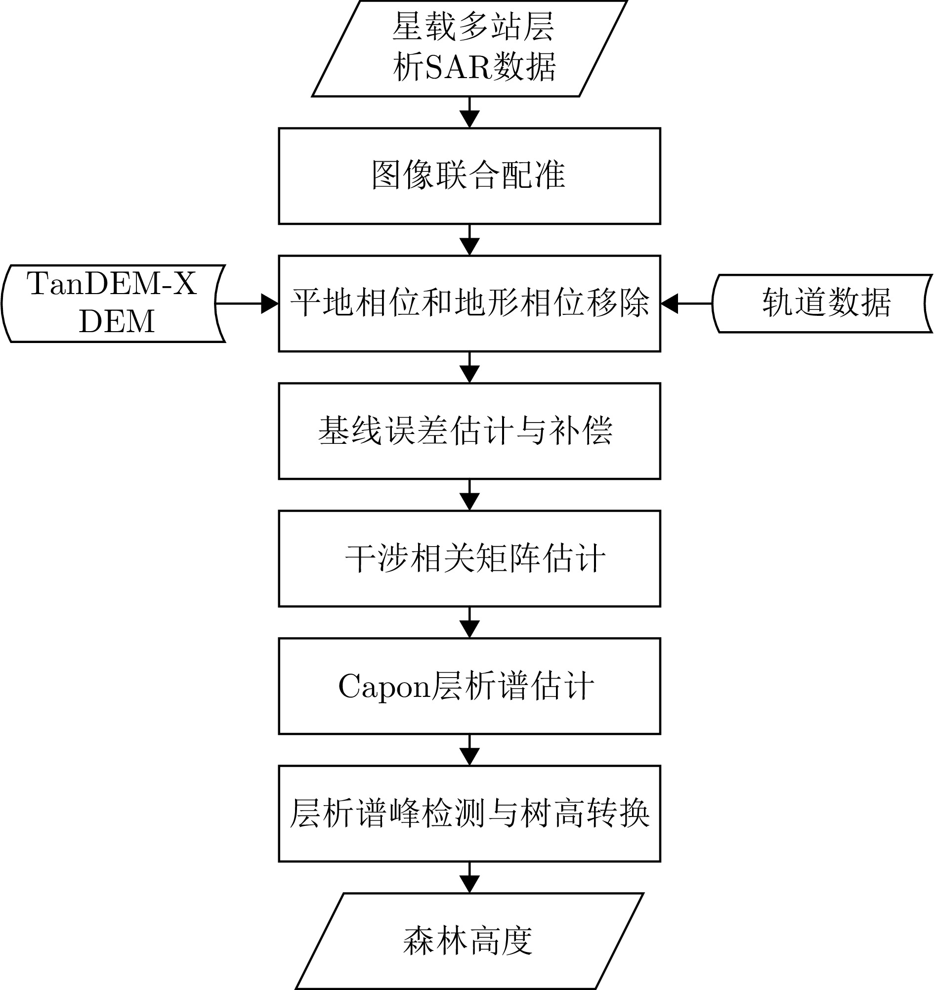
- Figure 1. Flowchart of spaceborne multi-static SAR tomography and forest height estimation
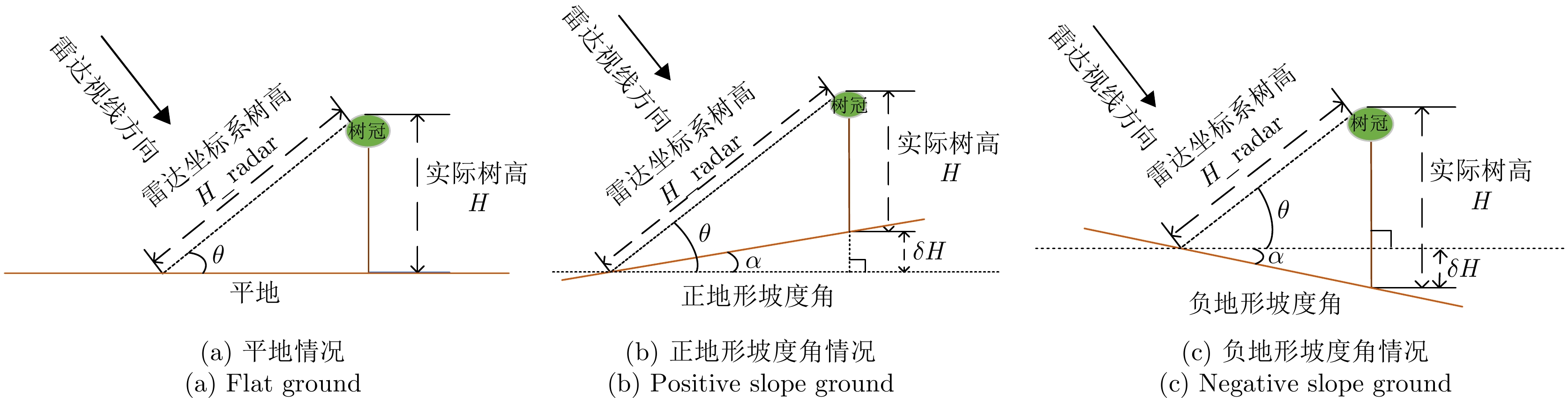
- Figure 2. Transformations between tree height in radar coordinates and actual tree height in geographic coordinates
- Figure 3. Geographic locations of the two test sites
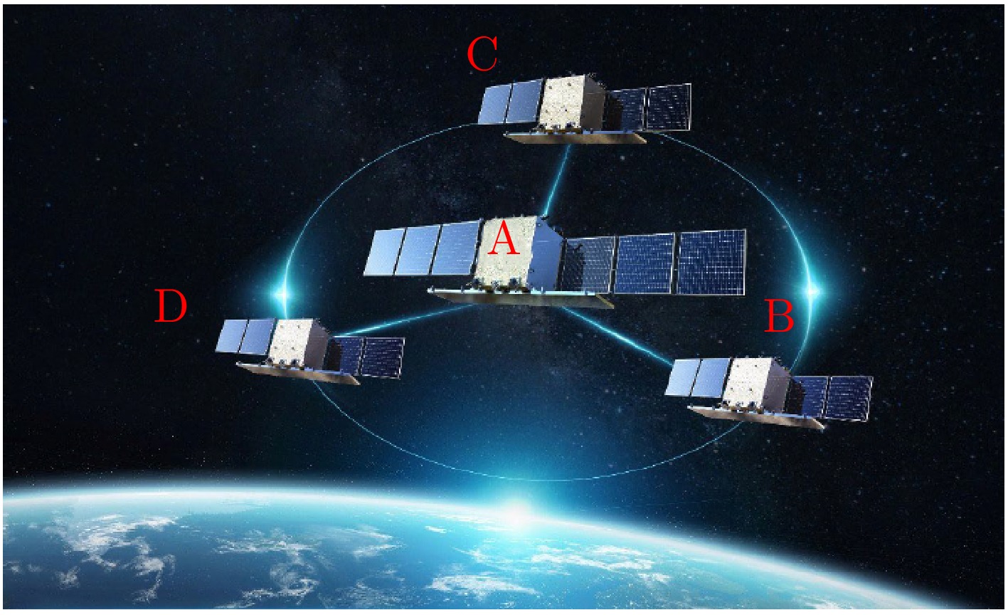
- Figure 4. Configuration of Hongtu-1 multi-static radar system
- Figure 5. SAR intensity images of the two test sites
- Figure 6. Baseline distributions of the two test sites
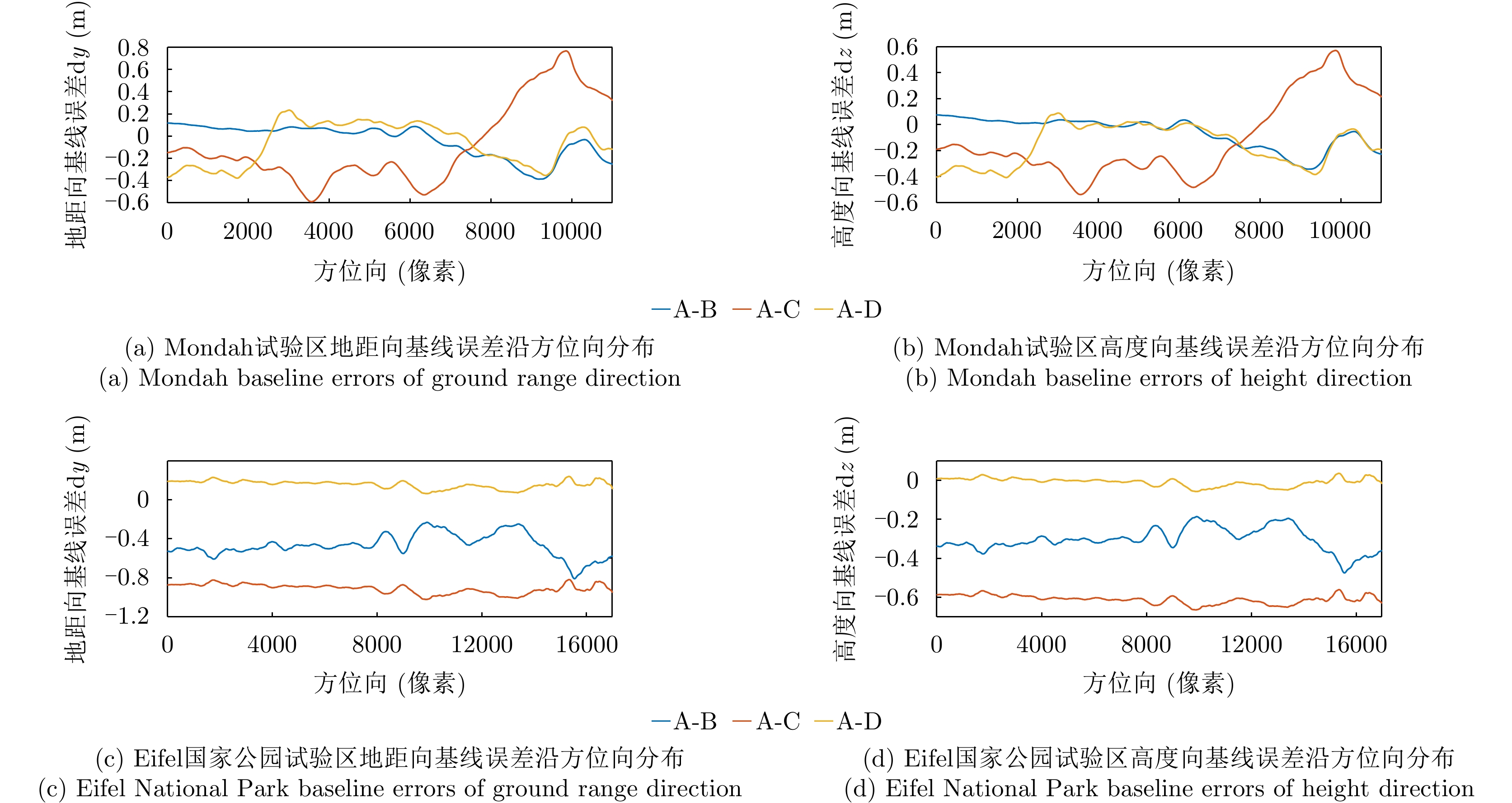
- Figure 7. Baseline error estimations of the two test sites
- Figure 8. Interferogram and coherence of the two test sites before and after phase calibration
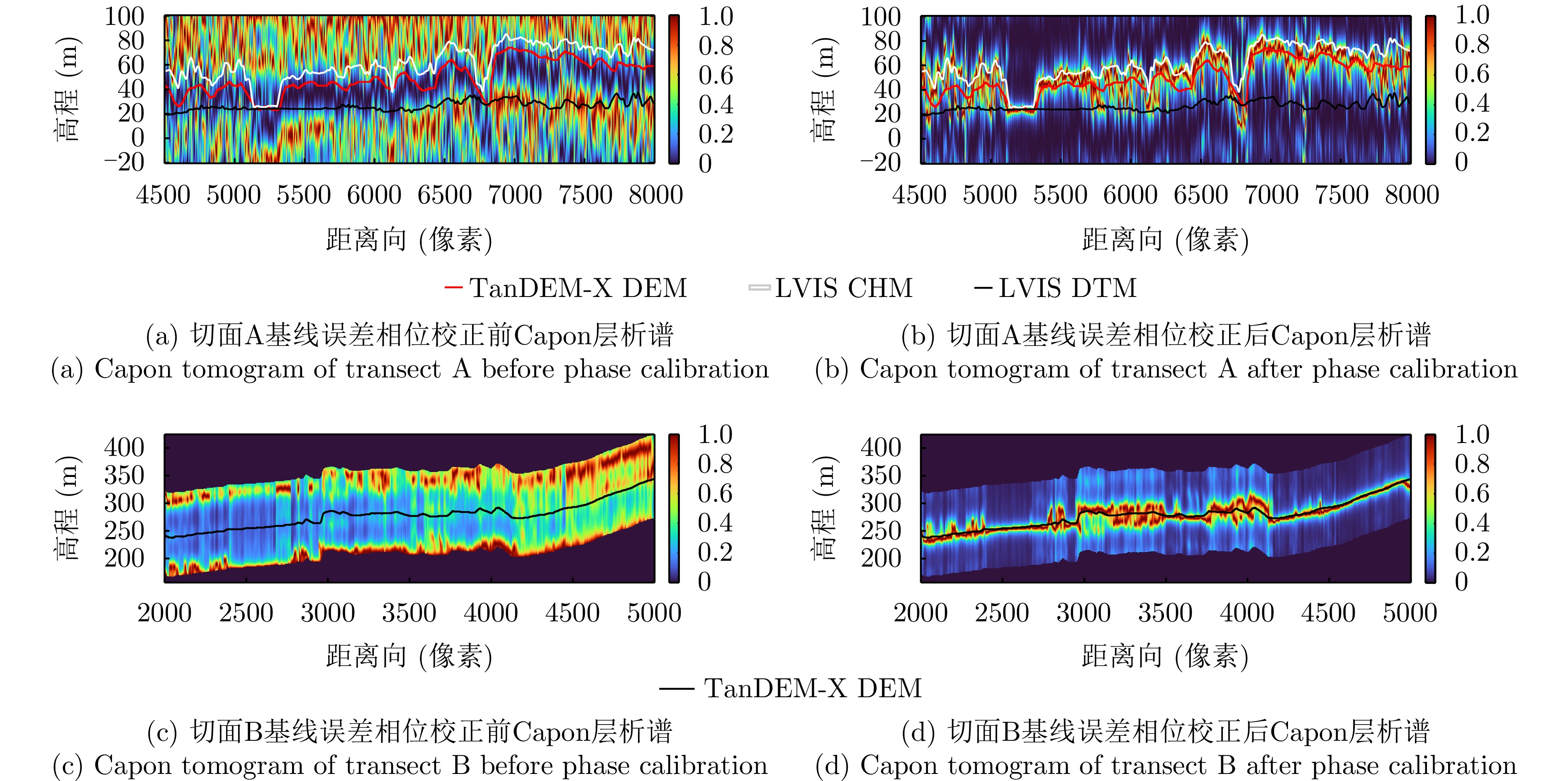
- Figure 9. Tomograms of transect A and transect B before and after phase calibration
- Figure 10. Forest height of area C in Eifel National Park test site by GEDI, Hongtu-1 TomoSAR and airborne LiDAR measurement
- Figure 11. 2D joint distribution between GEDI, Hongtu-1 TomoSAR and airborne LiDAR