
 Submit Manuscript
 Peer Review
 Editor Work
- Home
- Articles & Issues
-
Data
- Dataset of Radar Detecting Sea
- SAR Dataset
- SARGroundObjectsTypes
- SARMV3D
- AIRSAT Constellation SAR Land Cover Classification Dataset
- 3DRIED
- UWB-HA4D
- LLS-LFMCWR
- FAIR-CSAR
- MSAR
- SDD-SAR
- FUSAR
- SpaceborneSAR3Dimaging
- Sea-land Segmentation
- SAR Multi-domain Ship Detection Dataset
- SAR-Airport
- Hilly and mountainous farmland time-series SAR and ground quadrat dataset
- SAR images for interference detection and suppression
- HP-SAR Evaluation & Analytical Dataset
- GDHuiYan-ATRNet
- Multi-System Maritime Low Observable Target Dataset
- DatasetinthePaper
- DatasetintheCompetition
- Report
- Course
- About
- Publish
- Editorial Board
- Chinese
| Citation: | YU Yang, JIN Guowang, XIONG Xin, et al. SAR elevation control point extraction combining multistrategy ATLAS data preference and image matching[J]. Journal of Radars, 2023, 12(1): 64–75. doi: 10.12000/JR22134

|
SAR Elevation Control Point Extraction Combining Multistrategy ATLAS Data Preference and Image Matching
DOI: 10.12000/JR22134 CSTR: 32380.14.JR22134
More Information-
Abstract
To refine the geometric parameters of satellite-based SAR images and improve the stereo positioning accuracy, a method of SAR elevation control point extraction combining multistrategy ATLAS data preference and image matching has been developed. This method is based on the concept of optical remote sensing image elevation control point extraction from satellite-based laser altimetry data. The method employs various strategies, such as non-night observation photon filtering, high confidence photon selection, SRTM DEM-assisted coarse difference rejection, and large eccentricity elliptical filtering kernel flat area photon screening. To extract laser elevation points with high quality and flat area from ATLAS data for ATL03 level products. Then the geocoding of the slant range SAR images is performed using the SRTM DEM. The local Google Earth images are selected as the footprint images according to the plane coordinates of the laser elevation points. The rank self-similarity descriptor is used to match the footprint images with the SAR geocoded images. The coordinates of the SAR images corresponding to the laser elevation points are obtained. Thus, SAR elevation control points are extracted. The extraction of GF-3 SAR elevation control points was performed using ATLAS data from two regions: Dengfeng, China, and Yokosuka, Japan. The geometric parameter refinement of SAR images using extracted elevation control points significantly improved the accuracy of stereo positioning and verified that the method for extracting elevation control points described in this paper is feasible and effective. -

-
References
[1] WANG Taoyang, LI Xin, ZHANG Guo, et al. Large-scale orthorectification of GF-3 SAR images without ground control points for China’s land area[J]. IEEE Transactions on Geoscience and Remote Sensing, 2022, 60: 1–17. doi: 10.1109/TGRS.2022.3142372[2] 润一. 高分三号卫星在轨几何定标及与高分二号光学卫星影像联合定位[D]. [硕士论文], 武汉大学, 2017.RUN Yi. On-orbit geometric calibration of GF-3 satellite and joint-positioning of GF-3 and GF-2 satellite images[D]. [Master dissertation], Wuhan University, 2017.[3] 张红敏, 靳国旺, 徐青, 等. 利用单个地面控制点的SAR图像高精度立体定位[J]. 雷达学报, 2014, 3(1): 85–91. doi: 10.3724/SP.J.1300.2014.13138ZHANG Hongmin, JIN Guowang, XU Qing, et al. Accurate positioning with stereo SAR images and one ground control point[J]. Journal of Radars, 2014, 3(1): 85–91. doi: 10.3724/SP.J.1300.2014.13138[4] 魏钜杰, 张继贤, 赵争, 等. 稀少控制下TerraSAR-X影像高精度直接定位方法[J]. 测绘科学, 2011, 36(1): 58–60, 50. doi: 10.16251/j.cnki.1009-2307.2011.01.006WEI Jujie, ZHANG Jixian, ZHAO Zheng, et al. High-precisely direct geo-location method for TerraSAR-X image with sparse GCPs[J]. Science of Surveying and mapping, 2011, 36(1): 58–60, 50. doi: 10.16251/j.cnki.1009-2307.2011.01.006[5] 张祖勋, 陶鹏杰. 谈大数据时代的“云控制”摄影测量[J]. 测绘学报, 2017, 46(10): 1238–1248. doi: 10.11947/j.AGCS.2017.20170337ZHANG Zuxun and TAO Pengjie. An overview on “cloud control” photogrammetry in big data era[J]. Acta Geodaetica et Cartographica Sinica, 2017, 46(10): 1238–1248. doi: 10.11947/j.AGCS.2017.20170337[6] 方勇, 龚辉, 张丽, 等. 从全球激光点云到三维数字地球空间框架: 全球精确测绘进阶之路[J]. 激光与光电子学进展, 2022, 59(12): 1200002. doi: 10.3788/LOP202259.1200002FANG Yong, GONG Hui, ZHANG Li, et al. From global laser point cloud acquisition to 3D digital geospatial framework: The advanced road of global accurate mapping[J]. Laser &Optoelectronics Progress, 2022, 59(12): 1200002. doi: 10.3788/LOP202259.1200002[7] NEUMANN T A, MARTINO A J, MARKUS T, et al. The ice, cloud, and land elevation satellite-2 mission: A global geolocated photon product derived from the advanced topographic laser altimeter system[J]. Remote Sensing of Environment, 2019, 233: 111325. doi: 10.1016/j.rse.2019.111325[8] XIE Huan, XU Qi, YE Dan, et al. A comparison and review of surface detection methods using MBL, MABEL, and ICESat-2 photon-counting laser altimetry data[J]. IEEE Journal of Selected Topics in Applied Earth Observations and Remote Sensing, 2021, 14: 7604–7623. doi: 10.1109/JSTARS.2021.3094195[9] ICE, CLOUD, and land elevation satellite-2 (ICESat-2) algorithm theoretical basis document (ATBD) for global geolocated photons (ATL03)[EB/OL]. https://nsidc.org/sites/default/files/icesat2_atl03_atbd_r005_0.pdf, 2021.[10] LIN Xiaojuan, XU Min, CAO Chunxiang, et al. Estimates of forest canopy height using a combination of ICESat-2/ATLAS data and stereo-photogrammetry[J]. Remote Sensing, 2020, 12(21): 3649. doi: 10.3390/rs12213649[11] 张帅台, 李国元, 周晓青, 等. 基于多特征自适应的单光子点云去噪算法[J]. 红外与激光工程, 2022, 51(6): 20210949. doi: 10.3788/IRLA20210949ZHANG Shuaitai, LI Guoyuan, ZHOU Xiaoqing, et al. Single photon point cloud denoising algorithm based on multi-features adaptive[J]. Infrared and Laser Engineering, 2022, 51(6): 20210949. doi: 10.3788/IRLA20210949[12] ZHU Xiaoxiao, NIE Sheng, WANG Cheng, et al. A ground elevation and vegetation height retrieval algorithm using micro-pulse photon-counting Lidar data[J]. Remote Sensing, 2018, 10(12): 1962. doi: 10.3390/rs10121962[13] MARKUS T, NEUMANN T, MARTINO A, et al. The ice, cloud, and land elevation satellite-2 (ICESat-2): Science requirements, concept, and implementation[J]. Remote Sensing of Environment, 2017, 190: 260–273. doi: 10.1016/j.rse.2016.12.029[14] ROSIEK M R, KIRK R L, ARCHINAL B A, et al. Utility of Viking orbiter images and products for Mars mapping[J]. Photogrammetric Engineering & Remote Sensing, 2005, 71(10): 1187–1195. doi: 10.14358/PERS.71.10.1187[15] 何钰, 吴绍民, 邢帅. 基于RFM的嫦娥一号CCD影像区域网平差研究[J]. 测绘科学, 2013, 38(6): 5–6, 15. doi: 10.16251/j.cnki.1009-2307.2013.06.034HE Yu, WU Shaomin, and XING Shuai. Block adjustment of Chang’e-1 CCD images based on RFM[J]. Science of Surveying and Mapping, 2013, 38(6): 5–6, 15. doi: 10.16251/j.cnki.1009-2307.2013.06.034[16] 耿迅. 火星形貌摄影测量技术研究[D]. [博士论文], 解放军信息工程大学, 2014.GENG Xun. Research on photogrammetric processing for Mars topographic mapping[D]. [Ph. D. dissertation], Information Engineering University, 2014.[17] 王晋, 张勇, 张祖勋, 等. ICESat激光高程点辅助的天绘一号卫星影像立体区域网平差[J]. 测绘学报, 2018, 47(3): 359–369. doi: 10.11947/j.AGCS.2018.20170425WANG Jin, ZHANG Yong, ZHNAG Zuxun, et al. ICESat laser points assisted block adjustment for mapping Satellite-1 stereo imagery[J]. Acta Geodaetica et Cartographica Sinica, 2018, 47(3): 359–369. doi: 10.11947/j.AGCS.2018.20170425[18] 张鑫磊, 邢帅, 徐青, 等. ATLAS数据与资源三号02星影像联合区域网平差[J]. 红外与激光工程, 2020, 49(S2): 20200194. doi: 10.3788/IRLA20200194ZHANG Xinlei, XING Shuai, XU Qing, et al. Joint block adjustment for ATLAS data and ZY3-02 stereo imagery[J]. Infrared and Laser Engineering, 2020, 49(S2): 20200194. doi: 10.3788/IRLA20200194[19] ZHANG Guo, JIANG Boyang, WANG Taoyang, et al. Combined block adjustment for optical satellite stereo imagery assisted by spaceborne SAR and laser altimetry data[J]. Remote Sensing, 2021, 13(16): 3062. doi: 10.3390/rs13163062[20] 谭建伟, 程春泉. 建筑影像高程控制点的激光测高全波形分解提取[J]. 测绘科学, 2021, 46(8): 1–7, 13. doi: 10.16251/j.cnki.1009-2307.2021.08.001TAN Jianwei and CHENG Chunquan. Extracting building image elevation control points by decomposing full waveform of laser altimetry[J]. Science of Surveying and Mapping, 2021, 46(8): 1–7, 13. doi: 10.16251/j.cnki.1009-2307.2021.08.001[21] 王密, 韦钰, 杨博, 等. ICESat-2/ATLAS全球高程控制点提取与分析[J]. 武汉大学学报:信息科学版, 2021, 46(2): 184–192. doi: 10.13203/j.whugis20200531WANG Mi, WEI Yu, YANG Bo, et al. Extraction and analysis of global elevation control points from ICESat-2/ATLAS data[J]. Geomatics and Information Science of Wuhan University, 2021, 46(2): 184–192. doi: 10.13203/j.whugis20200531[22] 郑迎辉, 张艳, 王涛, 等. 基于ICESat-2数据的高程控制点提取和精度验证[J]. 地球信息科学学报, 2022, 24(7): 1234–1244. doi: 10.12082/dqxxkx.2022.210667ZHENG Yinghui, ZHANG Yan, WANG Tao, et al. Elevation control points extraction and accuracy validation based on ICESat-2 data[J]. Journal of Geo-Information Science, 2022, 24(7): 1234–1244. doi: 10.12082/dqxxkx.2022.210667[23] 中华人民共和国国家质量监督检验检疫总局, 中国国家标准化管理委员会. GB/T 12341-2008 1: 25000 1: 50000 1: 100000 地形图航空摄影测量外业规范[S]. 北京: 中国标准出版社, 2008.General Administration of Quality Supervision, Inspection and Quarantine of the People's Republic of China and Standardization Administration of China. GB/T 12341-2008 Specifications for aerophotogrammetric field work of 1∶25000 1∶50000 1∶100000 topographic maps[S]. Beijing: Standards Press of China, 2008.[24] 曹宁, 周平, 王霞, 等. 激光测高数据辅助卫星成像几何模型精化处理[J]. 遥感学报, 2018, 22(4): 599–610. doi: 10.11834/jrs.20187252CAO Ning, ZHOU Ping, WANG Xia, et al. Refined processing of laser altimeter data-aided satellite geometry model[J]. Journal of Remote Sensing, 2018, 22(4): 599–610. doi: 10.11834/jrs.20187252[25] 唐新明, 刘昌儒, 张恒, 等. 高分七号卫星立体影像与激光测高数据联合区域网平差[J]. 武汉大学学报:信息科学版, 2021, 46(10): 1423–1430. doi: 10.13203/j.whugis20210417TANG Xinming, LIU Changru, ZHANG Heng, et al. GF-7 satellite stereo images block adjustment assisted with laser altimetry data[J]. Geomatics and Information Science of Wuhan University, 2021, 46(10): 1423–1430. doi: 10.13203/j.whugis20210417[26] XIONG Xin, XU Qing, JIN Guowang, et al. Rank-based local self-similarity descriptor for optical-to-SAR image matching[J]. IEEE Geoscience and Remote Sensing Letters, 2020, 17(10): 1742–1746. doi: 10.1109/LGRS.2019.2955153[27] 王国安, 米鸿涛, 邓天宏, 等. 太阳高度角和日出日落时刻太阳方位角一年变化范围的计算[J]. 气象与环境科学, 2007, 30(S1): 161–164. doi: 10.16765/j.cnki.1673-7148.2007.s1.031WANG Guoan, MI Hongtao, DENG Tianhong, et al. Calculation of the change range of the sun high angle and the azimuth of sunrise and sunset in one year[J]. Meteorological and Environmental Sciences, 2007, 30(S1): 161–164. doi: 10.16765/j.cnki.1673-7148.2007.s1.031 -
Proportional views


- Publishing Ethics
- Journal Insights
- Abstracting & Indexing
- Peer Review Policies
- Guide for Authors
- Conference
- ISSN 2095-283X (Print)ISSN 2097-339X (Online)
- CN 10-1030/TN
- CODEN LXEUAO
About Journal
- Sponsor: China Radio Detection and Ranging Industry Association (CRIA)
- Phone: 010-58887062
- Email:radars@aircas.ac.cn
- Publisher: Leida Xuebao Bianjibu (Editorial office of the Journal of Radars)
Contacts Us

京ICP备20021838号-14
Supported by: Beijing Renhe Information Technology Co. Ltd

Export File
Citation
Format
Content
 DownLoad:

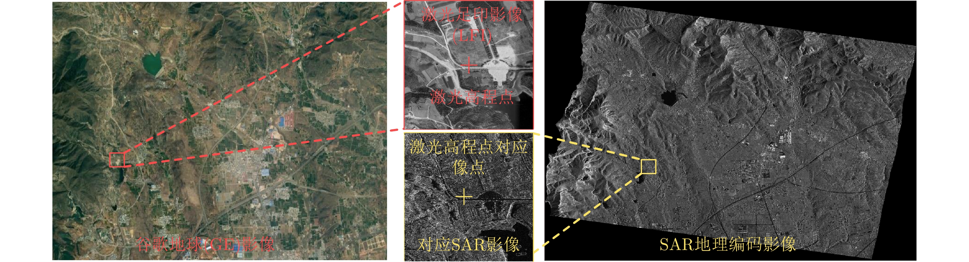
- Figure 1. Process of SAR elevation control point extraction combining multistrategy ATLAS data preference and image matching
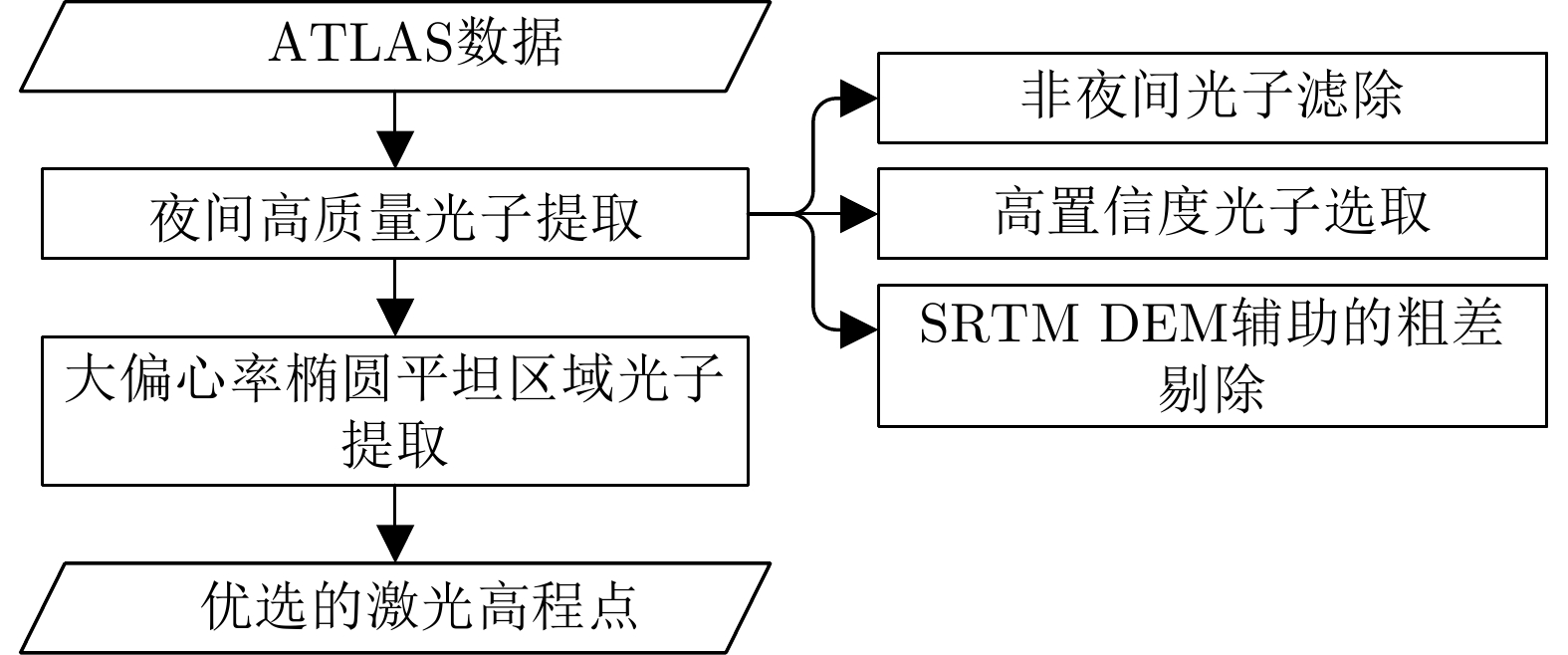
- Figure 2. Process of multistrategy ATLAS data preference
- Figure 3. Schematic diagram of height difference caused by difference between object and image
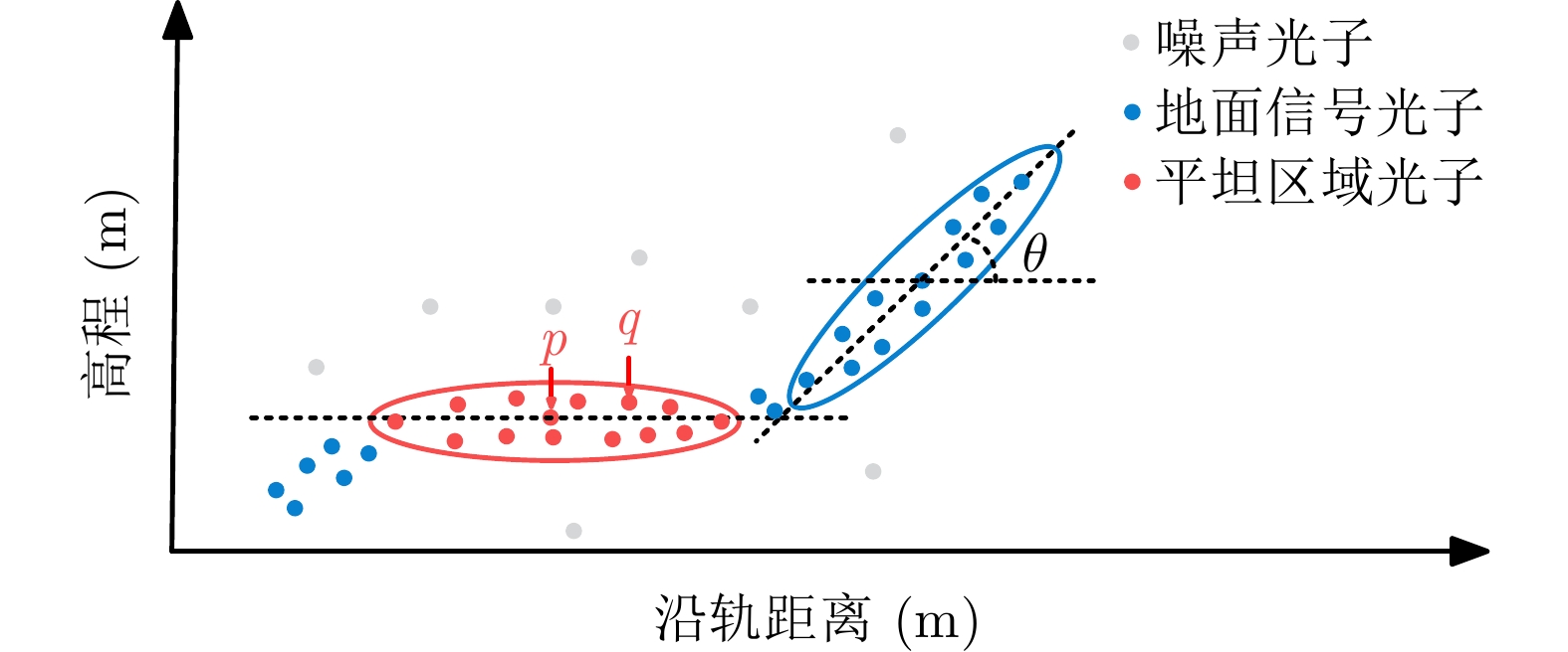
- Figure 4. Schematic diagram of ellipse filter kernel extraction
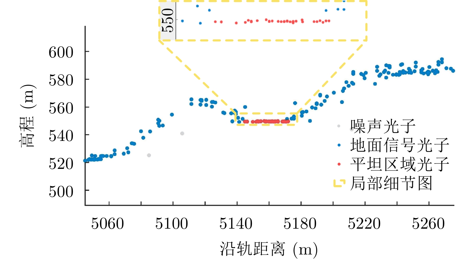
- Figure 5. Schematic diagram of laser points extraction result in flat area
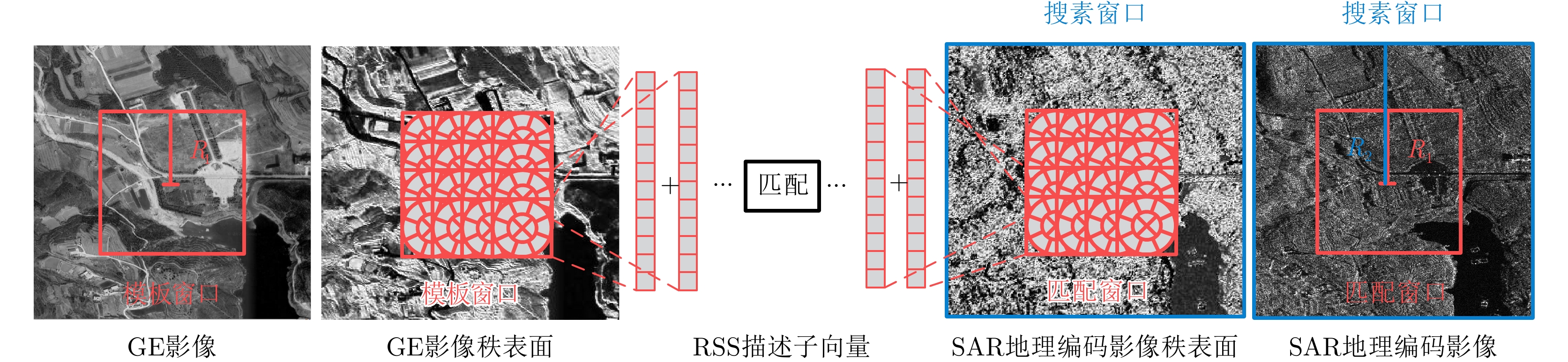
- Figure 6. Schematic diagram of matching between GE image and SAR geocoding image
- Figure 7. Matching window diagram
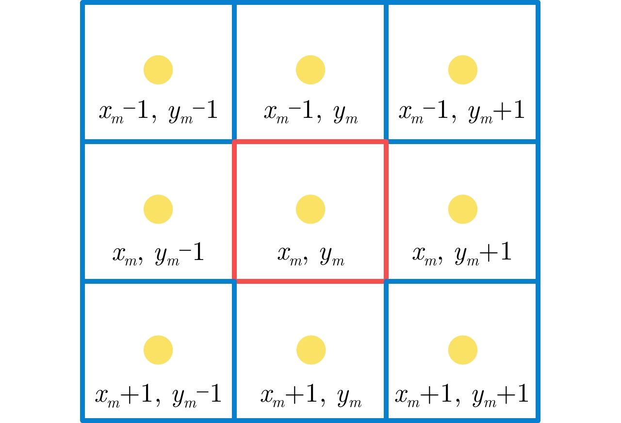
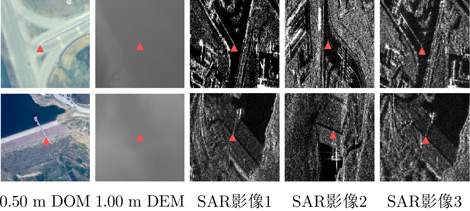
- Figure 8. Schematic diagram of matching points and neighborhood points
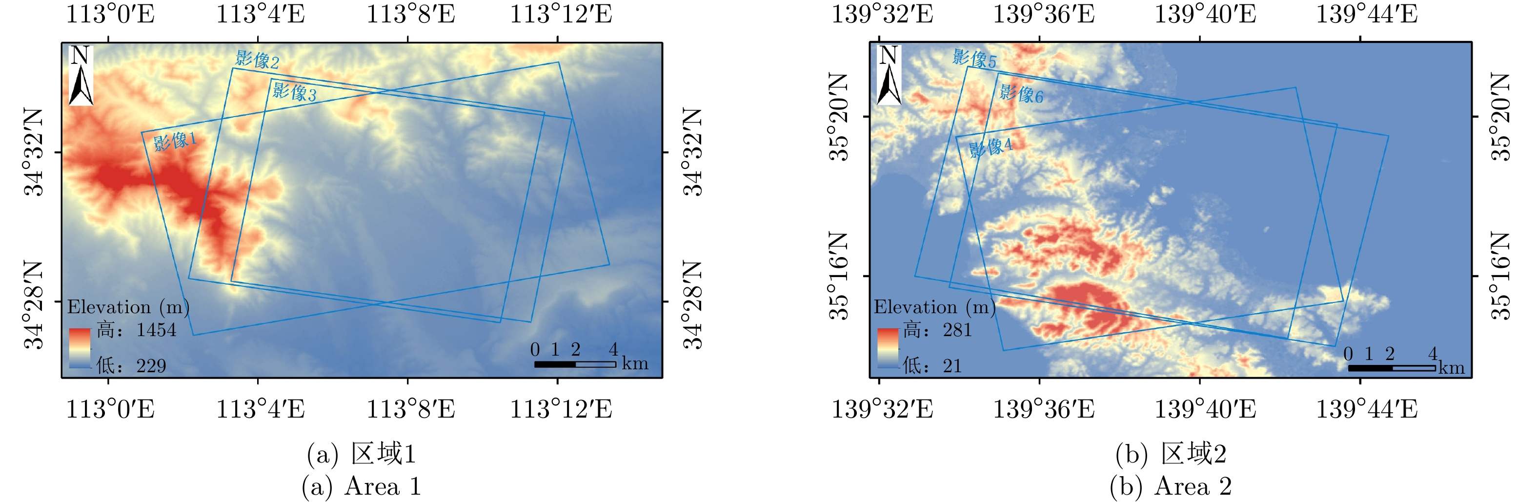
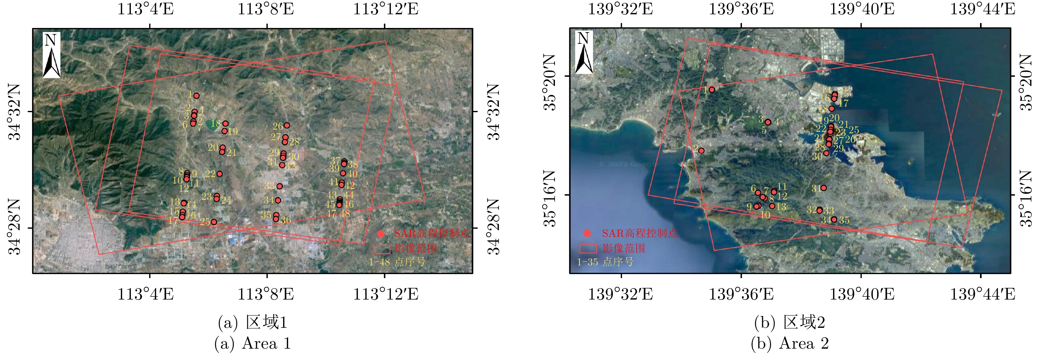
- Figure 9. Geographical location and topographic map of each area
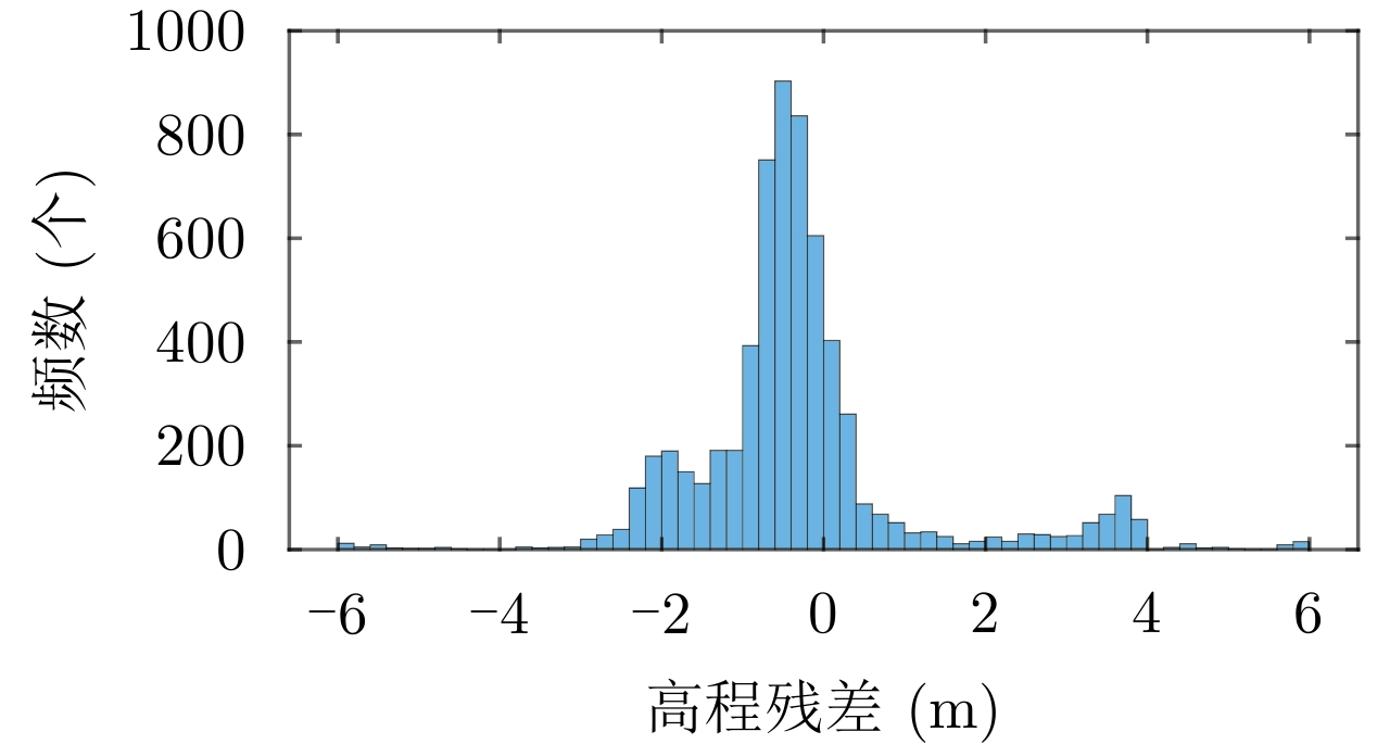
- Figure 10. Elevation difference histogram
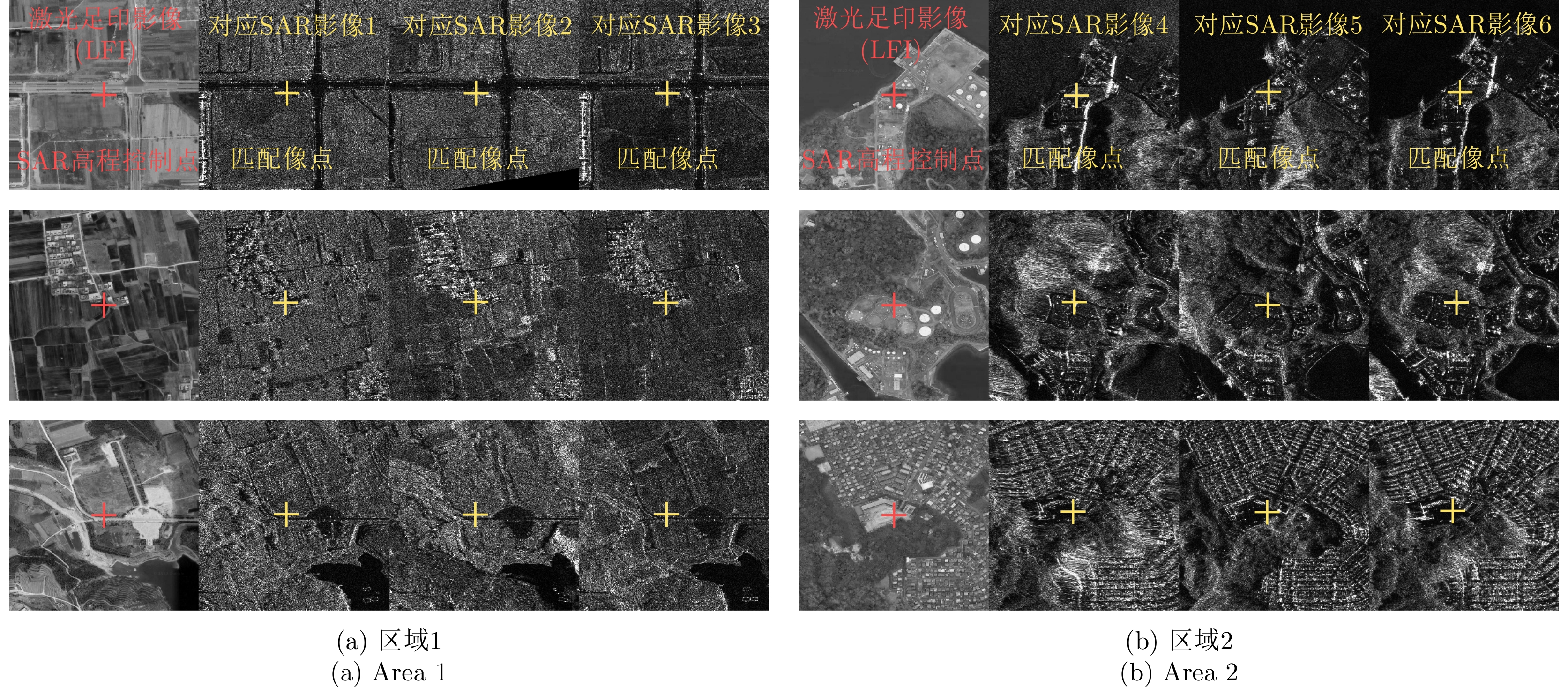
- Figure 11. Schematic diagram of matching results
- Figure 12. Schematic diagram of laser elevation point distribution
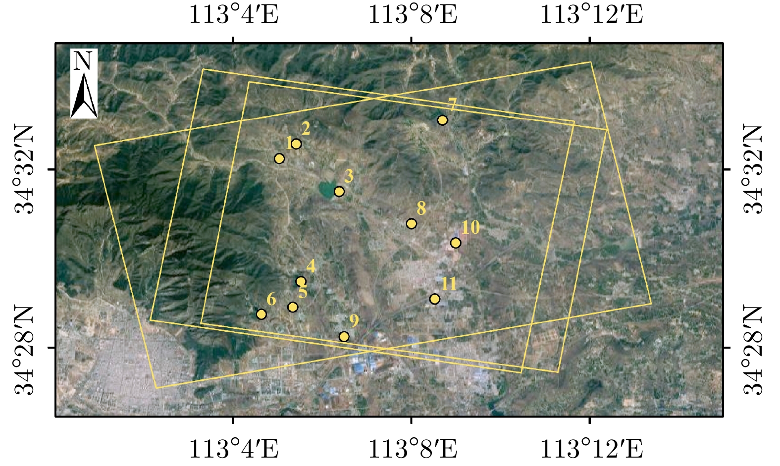
- Figure 13. Schematic diagram of some checkpoints in the area 1
- Figure 14. Schematic diagram of the distribution of checkpoints
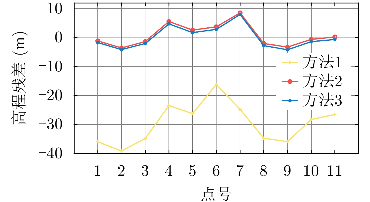
- Figure 15. Checkpoint error condition