
 Submit Manuscript
 Peer Review
 Editor Work
- Home
- Articles & Issues
-
Data
- Dataset of Radar Detecting Sea
- SAR Dataset
- SARGroundObjectsTypes
- SARMV3D
- AIRSAT Constellation SAR Land Cover Classification Dataset
- 3DRIED
- UWB-HA4D
- LLS-LFMCWR
- FAIR-CSAR
- MSAR
- SDD-SAR
- FUSAR
- SpaceborneSAR3Dimaging
- Sea-land Segmentation
- SAR Multi-domain Ship Detection Dataset
- SAR-Airport
- Hilly and mountainous farmland time-series SAR and ground quadrat dataset
- SAR images for interference detection and suppression
- HP-SAR Evaluation & Analytical Dataset
- GDHuiYan-ATRNet
- Multi-System Maritime Low Observable Target Dataset
- DatasetinthePaper
- DatasetintheCompetition
- Report
- Course
- About
- Publish
- Editorial Board
- Chinese

| Citation: | HU Xiaoning, WANG Bingnan, XIANG Maosheng, et al. InSAR elevation inversion method based on backprojection model with external DEM[J]. Journal of Radars, 2021, 10(3): 391–401. doi: 10.12000/JR20144

|
InSAR Elevation Inversion Method Based on Backprojection Model with External DEM
DOI: 10.12000/JR20144 CSTR: 32380.14.JR20144
More Information-
Abstract
When Interferometric Synthetic Aperture Radar (InSAR) is used to obtain the Digital Elevation Model (DEM), highly sloped terrains will make interferometric fringes dense and increase the difficulty of phase unwrapping, which will affect the accuracy of phase unwrapping and elevation inversion. To solve this problem, an InSAR elevation inversion method based on BackProjection (BP) model with an external DEM is proposed. This model achieves imaging and InSAR DEM inversion in a uniform BP geographic space and introduces an external DEM as auxiliary information. These processes, in turn, can remove most phases of the terrain and reduce the density of interferometric fringes and phase wrapping. Additionally, the proposed method can avoid the procedures of image registration and phase unwrapping in most cases, which simplifies traditional InSAR processing and achieves high processing accuracy. A simulation experiment and X-band InSAR data processing were performed to verify the effectiveness of the proposed method.-
Keywords:
- Elevation inversion,
- InSAR,
- External DEM,
- BackProjection (BP) algorithm,
- SAR
-

-
References
[1] WECHSLER S P. Uncertainties associated with digital elevation models for hydrologic applications: A review[J]. Hydrology and Earth System Sciences, 2007, 11(4): 1481–1500. doi: 10.5194/hess-11-1481-2007[2] YANG Kang, SMITH L C, CHU V W, et al. A caution on the use of surface digital elevation models to simulate supraglacial hydrology of the Greenland ice sheet[J]. IEEE Journal of Selected Topics in Applied Earth Observations and Remote Sensing, 2015, 8(11): 5212–5224. doi: 10.1109/JSTARS.2015.2483483[3] SHUKLA G, GARG R D, SRIVASTAVA H S, et al. Performance analysis of different predictive models for crop classification across an aridic to ustic area of Indian states[J]. Geocarto International, 2018, 33(3): 240–259. doi: 10.1080/10106049.2016.1240721[4] RUFINO G, MOCCIA A, and ESPOSITO S. DEM generation by means of ERS tandem data[J]. IEEE Transactions on Geoscience and Remote Sensing, 1998, 36(6): 1905–1912. doi: 10.1109/36.729362[5] 靳国旺, 徐青, 张红敏. 合成孔径雷达干涉测量[M]. 北京: 国防工业出版社, 2014: 169–183.JIN Guowang, XU Qing, and ZHANG Hongmin. Synthetic Aperture Radar Interferometry[M]. Beijing: National Defense Industry Press, 2014: 169–183.[6] SEYMOUR M S and CUMMING I G. InSAR terrain height estimation using low-quality sparse DEMs[C]. 3rd ERS Symposium, Florence, Italy, 1997: 421–426.[7] LIAO Mingsheng, WANG Teng, LU Lijun, et al. Reconstruction of DEMs from ERS-1/2 Tandem data in mountainous area facilitated by SRTM data[J]. IEEE Transactions on Geoscience and Remote Sensing, 2007, 45(7): 2325–2335. doi: 10.1109/TGRS.2007.896546[8] 刘辉, 靳国旺, 张红敏, 等. DEM辅助的山区InSAR相位解缠[J]. 测绘科学技术学报, 2017, 34(2): 215–220. doi: 10.3969/j.issn.1673-6338.2017.02.019LIU Hui, JIN Guowang, ZHANG Hongmin, et al. Phase unwrapping assisted by DEM of InSAR for mountainous terrain[J]. Journal of Geomatics Science and Technology, 2017, 34(2): 215–220. doi: 10.3969/j.issn.1673-6338.2017.02.019[9] FARR T G, ROSEN P A, CARO E, et al. The shuttle radar topography mission[J]. Reviews of Geophysics, 2007, 45(2): RG2004. doi: 10.1029/2005RG000183[10] FUJISADA H, BAILEY G B, KELLY G G, et al. ASTER DEM performance[J]. IEEE Transactions on Geoscience and Remote Sensing, 2005, 43(12): 2707–2714. doi: 10.1109/TGRS.2005.847924[11] CRIPPEN R, BUCKLEY S, AGRAM P, et al. NASADEM global elevation model: Methods and progress[C]. XXIII ISPRS Congress, Prague, Czech Republic, 2016: 125–128. doi: 10.5194/isprsarchives-XLI-B4-125-2016.[12] LIN Jianhe, LÜ Xiaolei, and LI Rui. Automatic registered back-projection approach based on object orientation for airborne repeat-track interferometric SAR[J]. IET Radar, Sonar & Navigation, 2018, 12(9): 1066–1076. doi: 10.1049/iet-rsn.2018.5053[13] DUERSCH M I. Backprojection for synthetic aperture radar[D]. [Ph. D. dissertation], Brigham Young University, 2013.[14] 韦顺军, 师君, 张晓玲, 等. 基于曲面投影的毫米波InSAR数据成像方法[J]. 雷达学报, 2015, 4(1): 49–59. doi: 10.12000/JR14137WEI Shunjun, SHI Jun, ZHANG Xiaoling, et al. Millimeter-wave interferometric synthetic aperture radar data imaging based on terrain surface projection[J]. Journal of Radars, 2015, 4(1): 49–59. doi: 10.12000/JR14137[15] ZEBKER H. User-friendly InSAR products – do we need range-Doppler?[C]. 12th European Conference on Synthetic Aperture Radar, Aachen, Germany, 2018: 1–4.[16] 师君, 马龙, 韦顺军, 等. 基于导航数据的Ka波段InSAR成像处理与分析[J]. 雷达学报, 2014, 3(1): 19–27. doi: 10.3724/SP.J.1300.2014.13142SHI Jun, MA Long, WEI Shunjun, et al. Ka-band InSAR imaging and analysis based on IMU data[J]. Journal of Radars, 2014, 3(1): 19–27. doi: 10.3724/SP.J.1300.2014.13142[17] 潘舟浩, 李道京, 刘波, 等. 基于BP算法和时变基线的机载InSAR数据处理方法研究[J]. 电子与信息学报, 2014, 36(7): 1585–1591. doi: 10.3724/SP.J.1146.2013.00715PAN Zhouhao, LI Daojing, LIU Bo, et al. Processing of the airborne InSAR data based on the BP algorithm and the time-varying baseline[J]. Journal of Electronics &Information Technology, 2014, 36(7): 1585–1591. doi: 10.3724/SP.J.1146.2013.00715[18] 韦顺军, 张晓玲, 师君, 等. 同空间后向投影InSAR成像及干涉相位提取方法[J]. 宇航学报, 2015, 36(3): 336–343. doi: 10.3873/j.issn.1000-1328.2015.03.013WEI Shunjun, ZHANG Xiaoling, SHI Jun, et al. InSAR imaging and interferogram extraction-based the same space back-projection[J]. Journal of Astronautics, 2015, 36(3): 336–343. doi: 10.3873/j.issn.1000-1328.2015.03.013[19] SOUMEKH M. Synthetic Aperture Radar Signal Processing with MATLAB Algorithms[M]. New York: Wiley. 1999.[20] 王超, 张红, 刘智. 星载合成孔径雷达干涉测量[M]. 北京: 科学出版社, 2002: 33–37.WANG Chao, ZHANG Hong, and LIU Zhi. Spaceborne Synthetic Aperture Radar Interferometry[M]. Beijing: Science Press, 2002: 33–37. -
Proportional views


- Publishing Ethics
- Journal Insights
- Abstracting & Indexing
- Peer Review Policies
- Guide for Authors
- Conference
- ISSN 2095-283X (Print)ISSN 2097-339X (Online)
- CN 10-1030/TN
- CODEN LXEUAO
About Journal
- Sponsor: China Radio Detection and Ranging Industry Association (CRIA)
- Phone: 010-58887062
- Email:radars@aircas.ac.cn
- Publisher: Leida Xuebao Bianjibu (Editorial office of the Journal of Radars)
Contacts Us

京ICP备20021838号-14
Supported by: Beijing Renhe Information Technology Co. Ltd

Export File
Citation
Format
Content
 DownLoad:

- Figure 1. The interferometric model based on BP imaging algorithm
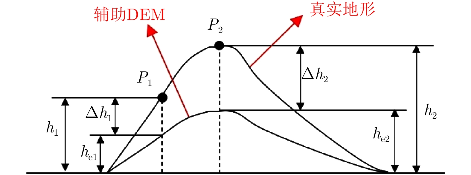
- Figure 2. Geometric description of the height of ambiguity
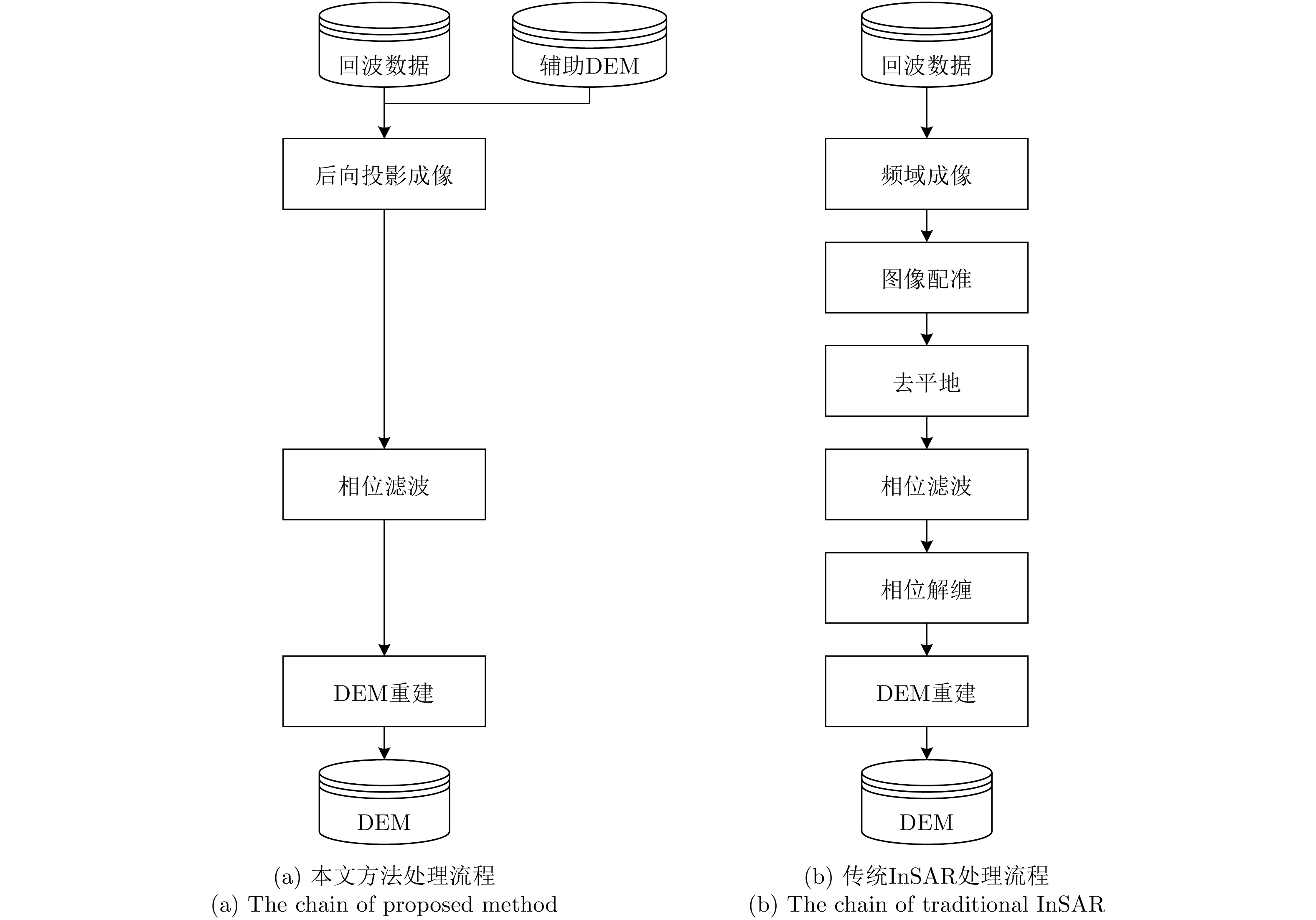
- Figure 3. InSAR processing chain
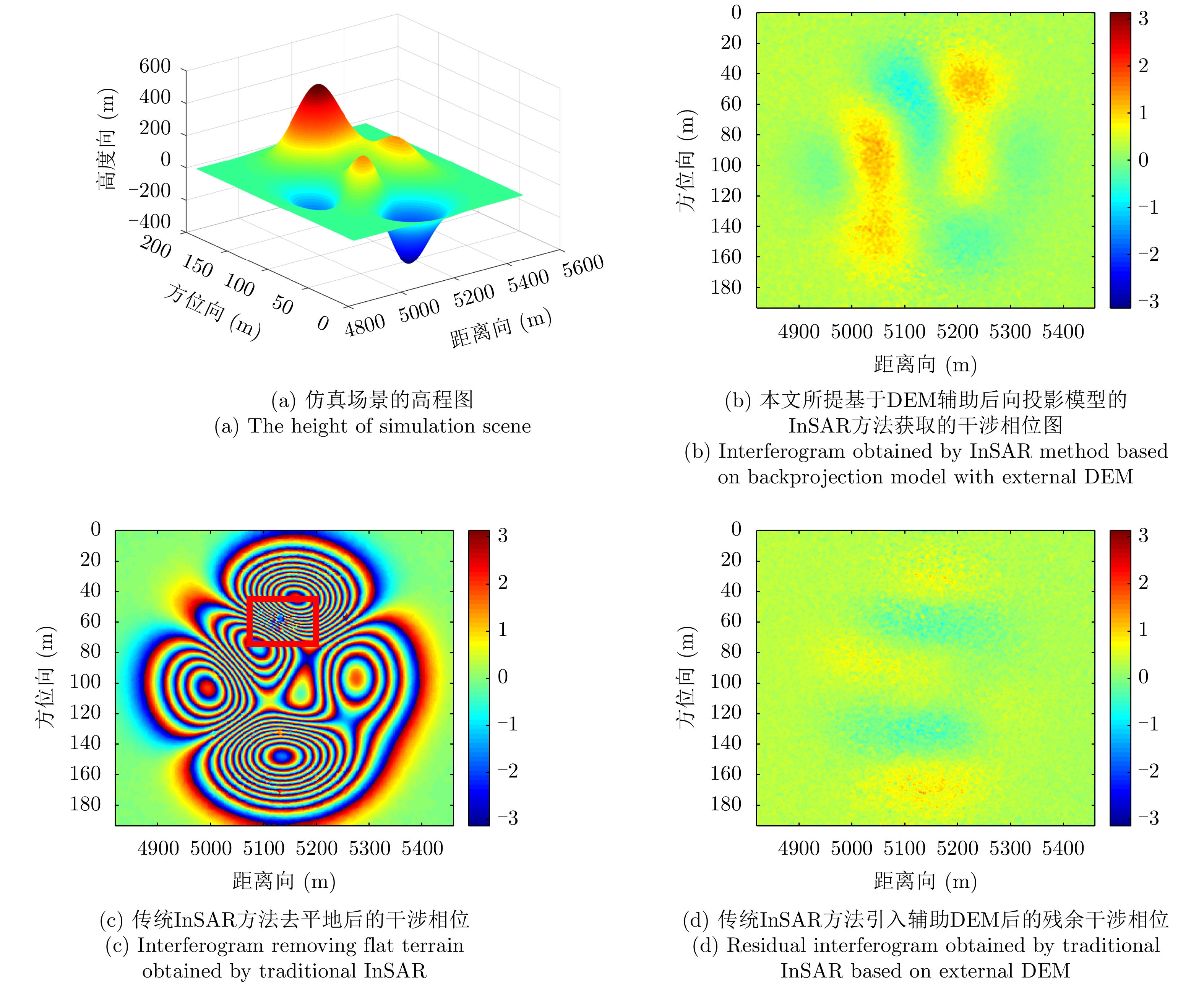
- Figure 4. Simulation results
- Figure 5. The elevation inversion errors of two methods
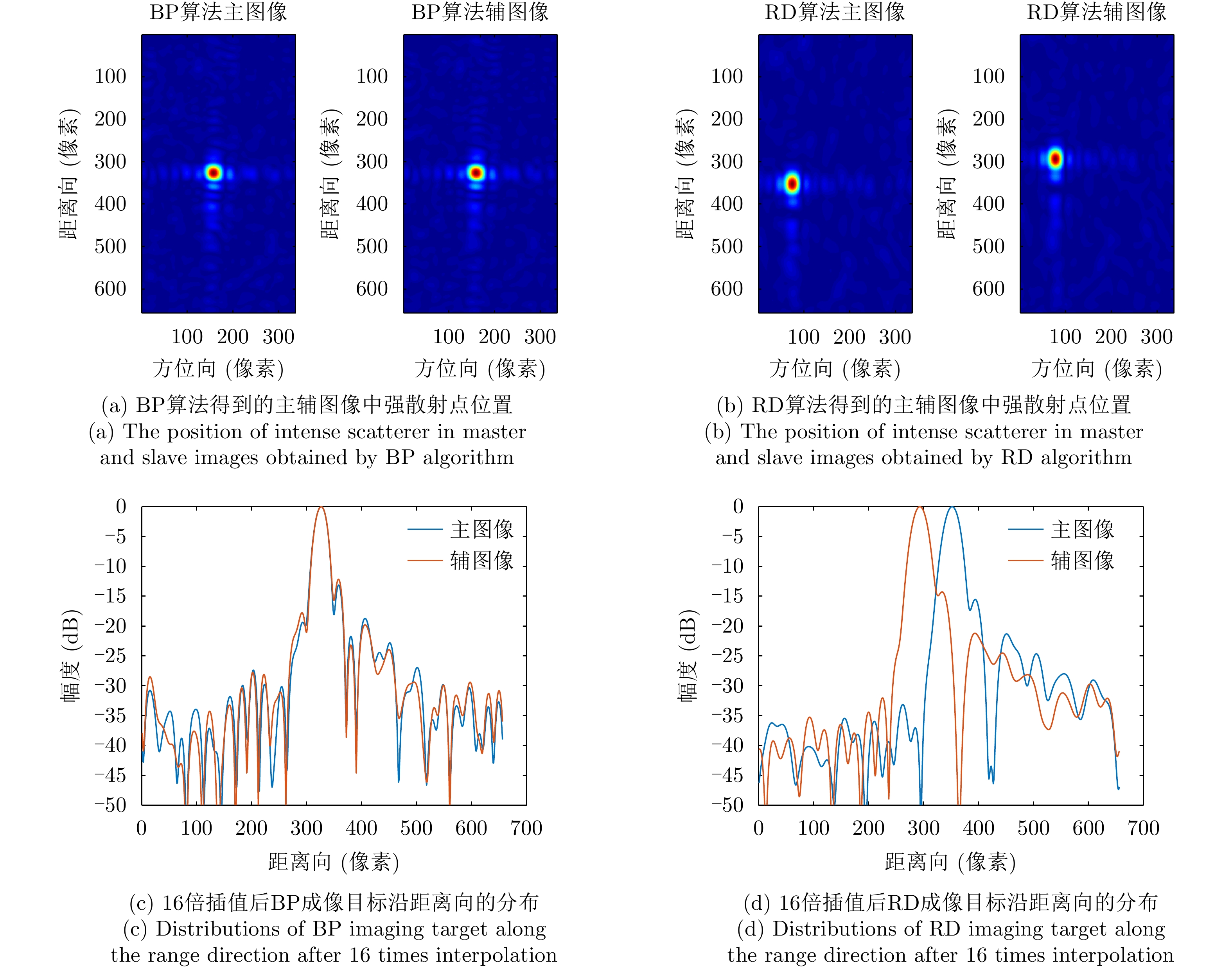
- Figure 6. The focused images of intense scatterer
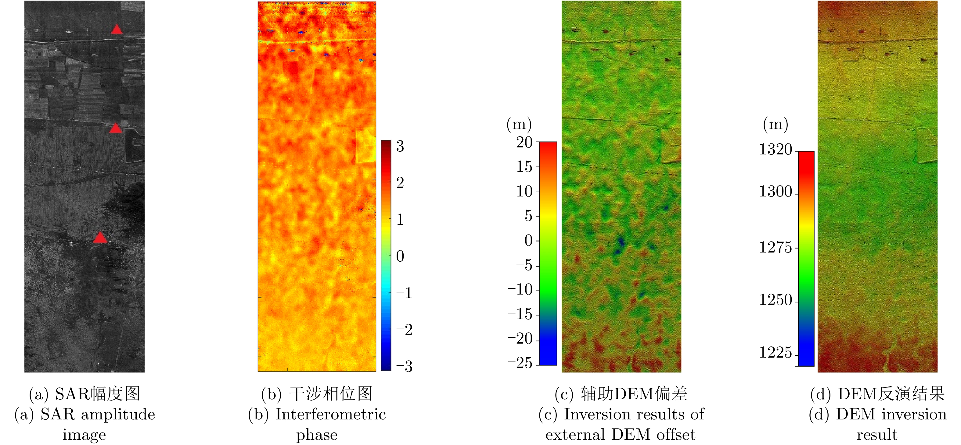
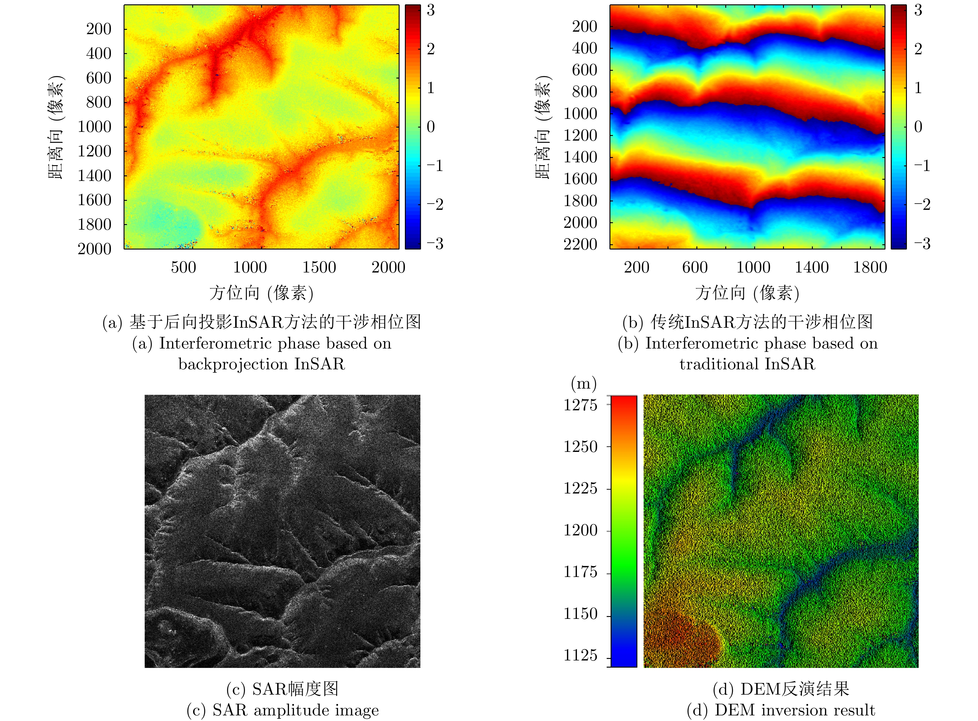
- Figure 7. Airborne InSAR data processing results
- Figure 8. Airborne InSAR data processing results of mountainous area