
 作者中心
作者中心 专家审稿
专家审稿 责编办公
责编办公 编辑办公
编辑办公
Research on Automatic Control Point Extraction and Correction Method for High-resolution Synthetic Aperture Radar Imagery Assisted by Multi-source Data
-
摘要: 控制点作为遥感影像定位精度提升的核心基准,其空间分布特征与几何质量直接影响正射校正的可靠性,是保障多源影像融合、变化检测及定量反演精度的关键基础。针对传统角反射器布设成本高、实施难度大,难以满足全球应用需求的问题,以及现有异源控制点(如光学影像和激光测高数据)因与合成孔径雷达(SAR)影像存在显著模态差异,难以兼顾精度与鲁棒性的问题,该研究提出一种基于众源数据的高分辨率SAR影像控制点自动提取方法,并构建了基于控制片的高精度正射校正技术框架。该方法充分利用城市环境中广泛分布的杆状人造地物特性:在光学影像中,这类地物呈现本体-阴影协同结构特征,在SAR影像中则表现为十字形强散射响应。首先利用开源机场跑道数据校正谷歌光学影像,建立平面基准框架;进而通过光学-SAR影像匹配点与立体SAR影像匹配点的协同平差解算,实现不同升降轨立体SAR影像的初始定位优化;最终结合道路和停车场矢量数据提取感兴趣区域,采用信杂比检测算法识别强散射点,并通过点目标分析与立体定位技术获取控制点的三维空间坐标。基于控制点坐标对立体SAR影像的残余平面误差进行修正后,可生成不同升降轨SAR影像的控制片数据。通过采用多个区域的高分三号升降轨SAR影像开展控制点提取验证,结果表明:基于聚束模式立体SAR影像提取的控制点三维定位精度达亚米级,基于提取的控制点和控制片实现了测试影像的正射校正,通过角反射器和机载激光点云真值验证,结果发现测试影像定位精度提升显著,其中聚束模式定位误差为1.78像素,超精细条带模式为1.09像素,精细条带模式为0.82像素,较传统光学参考影像匹配校正方法精度提升了47.2%, 49.3%和37.4%。该研究创新性地引入众源信息辅助SAR控制点提取和升降轨SAR控制片构建,突破光学参考底图匹配校正的精度瓶颈,为高分辨率SAR影像精确定位与联合处理提供了可推广的新路径。Abstract: Ground Control Points (GCPs) are essential for improving the positioning accuracy of remote sensing imagery. Their spatial distribution and geometric quality directly affect the reliability of orthorectification. GCPs serve as a critical foundation for ensuring the accuracy of multi-source image fusion, change detection, and quantitative inversion. However, traditional corner reflector deployment presents high costs and implementation difficulties, struggling to meet global application demands. Additionally, existing heterogeneous control points (such as optical imagery and laser altimetry data) exhibit significant modal differences relative to Synthetic Aperture Radar (SAR) imagery, which affects their ability to balance accuracy and robustness. To address these challenges, this study proposes an automatic control point extraction method for high-resolution SAR imagery based on multi-source data. Furthermore, a high-precision orthorectification framework is established using control chips. The method leverages the characteristics of widely distributed pole-like artificial features in urban environments: these features exhibit a body-shadow collaborative structure in optical imagery and a cross-shaped strong scattering response in SAR imagery. First, open-source airport runway data are used to correct Google optical imagery, establishing a planar reference framework. Next, initial positioning optimization for stereo SAR images from ascending and descending orbits is achieved by jointly adjusting optical-SAR and stereo SAR image matching points. Finally, road and parking lot vector data are utilized to extract regions of interest, where strong scattering points are identified using a signal-to-clutter ratio detection algorithm. Three-dimensional spatial coordinates of control points are obtained via point target analysis and stereo positioning techniques. After correcting residual planar errors in stereo SAR images using control point coordinates, control chip data for ascending and descending orbit SAR images are generated. Validation experiments using GaoFen-3 SAR images from multiple regions show that the 3D positioning accuracy of control points extracted from spotlight mode stereo SAR imagery reaches the submeter level. Orthorectification of test images using extracted control points and control chips significantly improves positioning accuracy, as verified by corner reflectors and airborne LiDAR point cloud-based ground truth. Positioning errors are 1.78 pixels (spotlight mode), 1.09 pixels (ultrafine stripmap mode), and 0.82 pixels (fine stripmap mode), corresponding to improvements of 47.2%, 49.3%, and 37.4%, respectively, compared to traditional optical reference image matching correction methods. This study introduces crowdsourced information to assist SAR control point extraction and ascending/descending orbit SAR control chip construction, overcoming the accuracy limitations of optical reference image matching correction. The proposed method provides a scalable approach for high-precision positioning and joint processing of high-resolution SAR imagery.
-
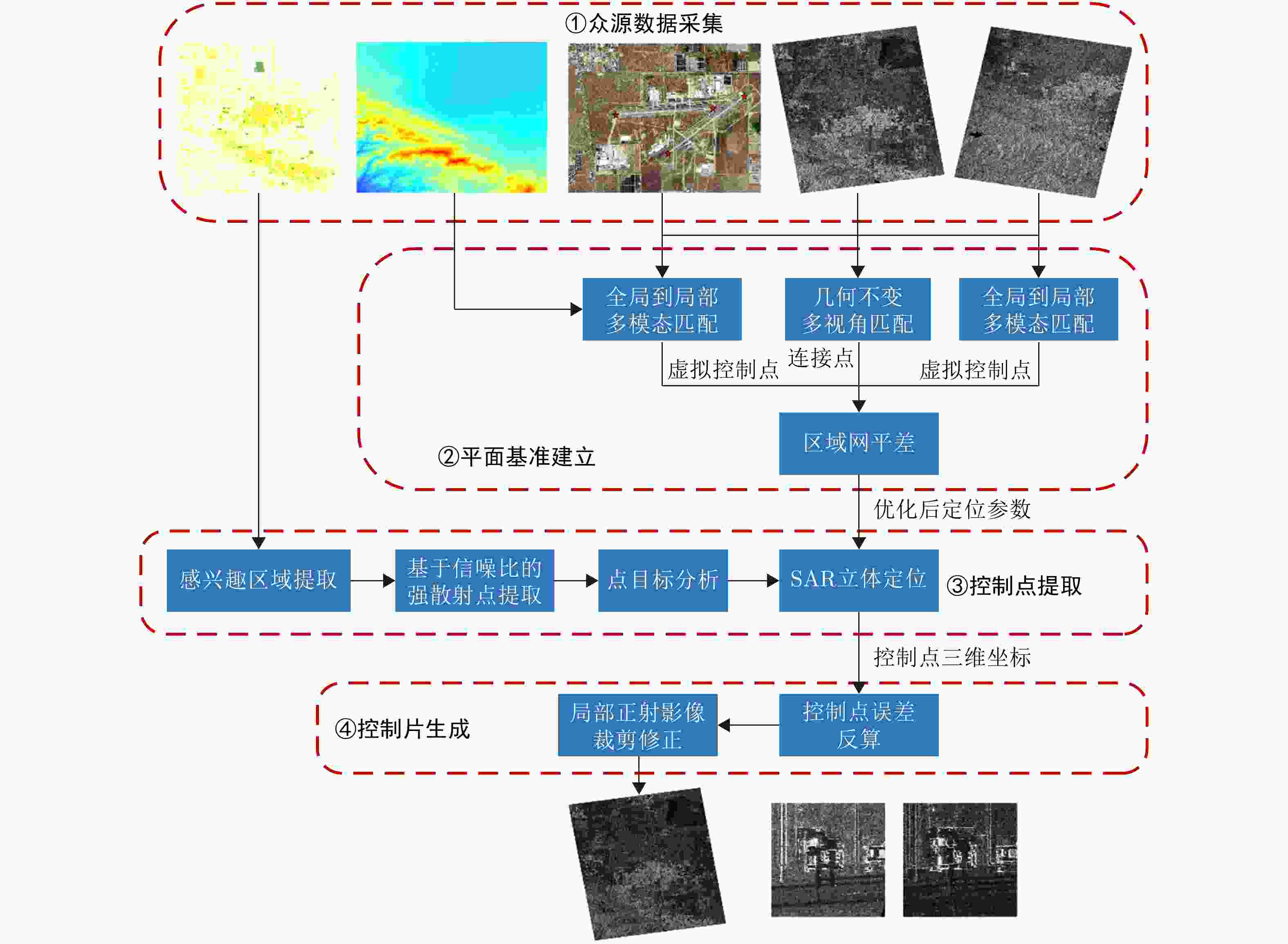
图 1 众源数据辅助的SAR影像控制点自动提取算法流程图
Figure 1. Flowchart of the automatic extraction algorithm for GCP in SAR images assisted by multi-sourced data
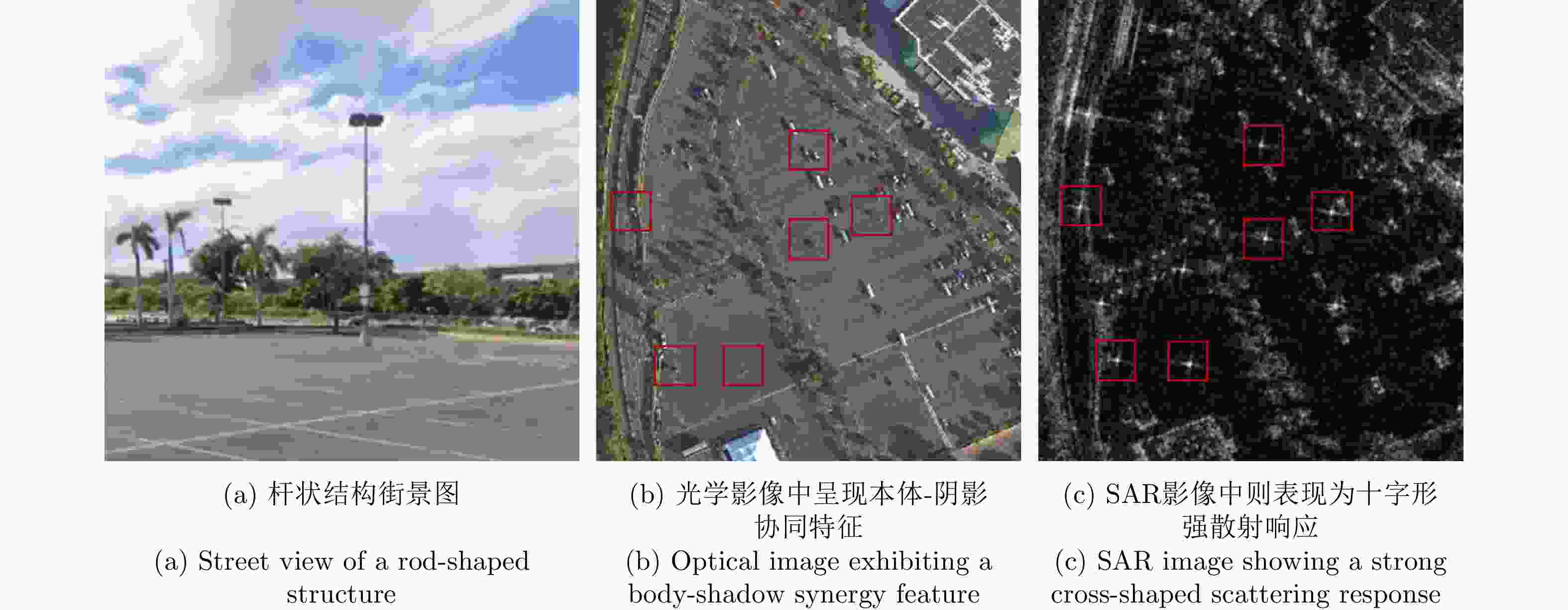
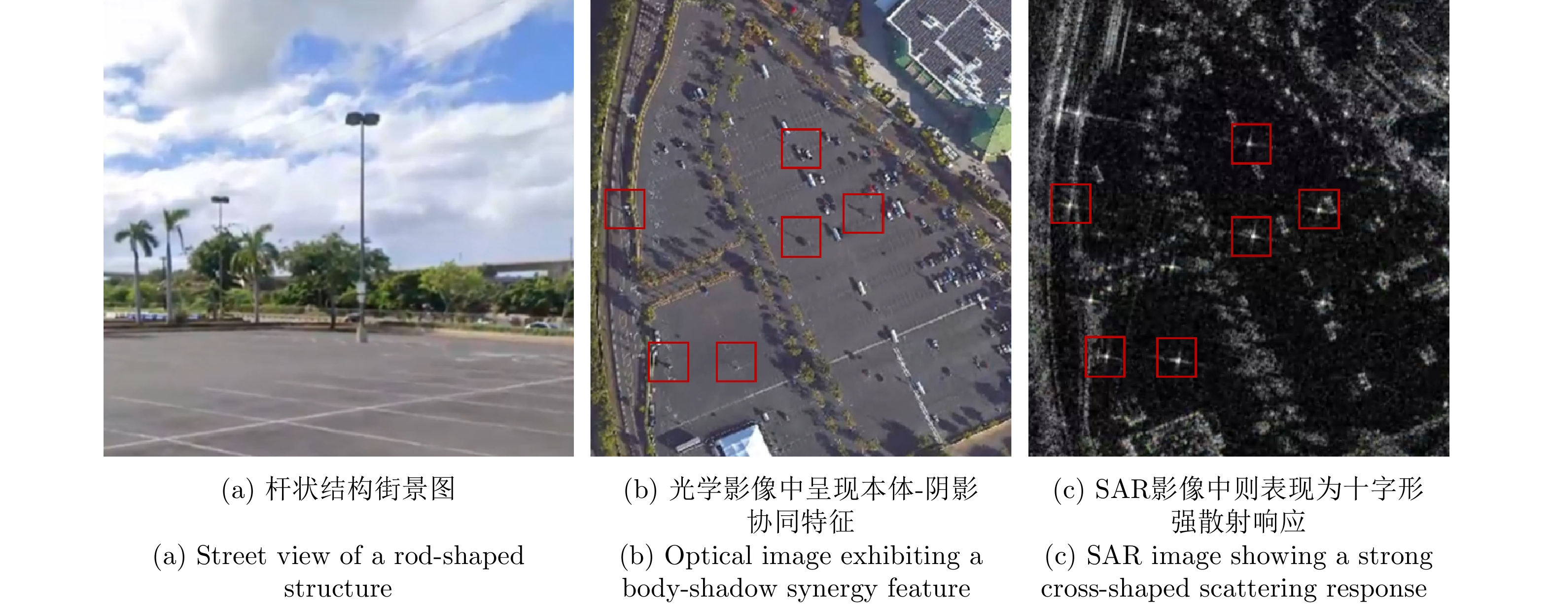
图 3 本项目控制点构造对象—杆状结构图示(如红色矩形框)
Figure 3. The rod-shaped structures used as control points in this project are indicated by red rectangles
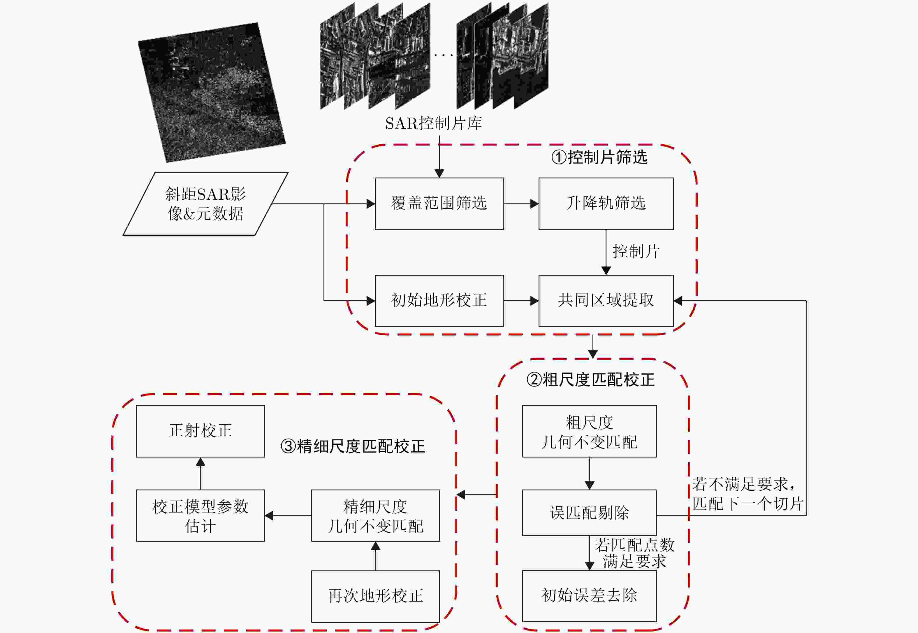
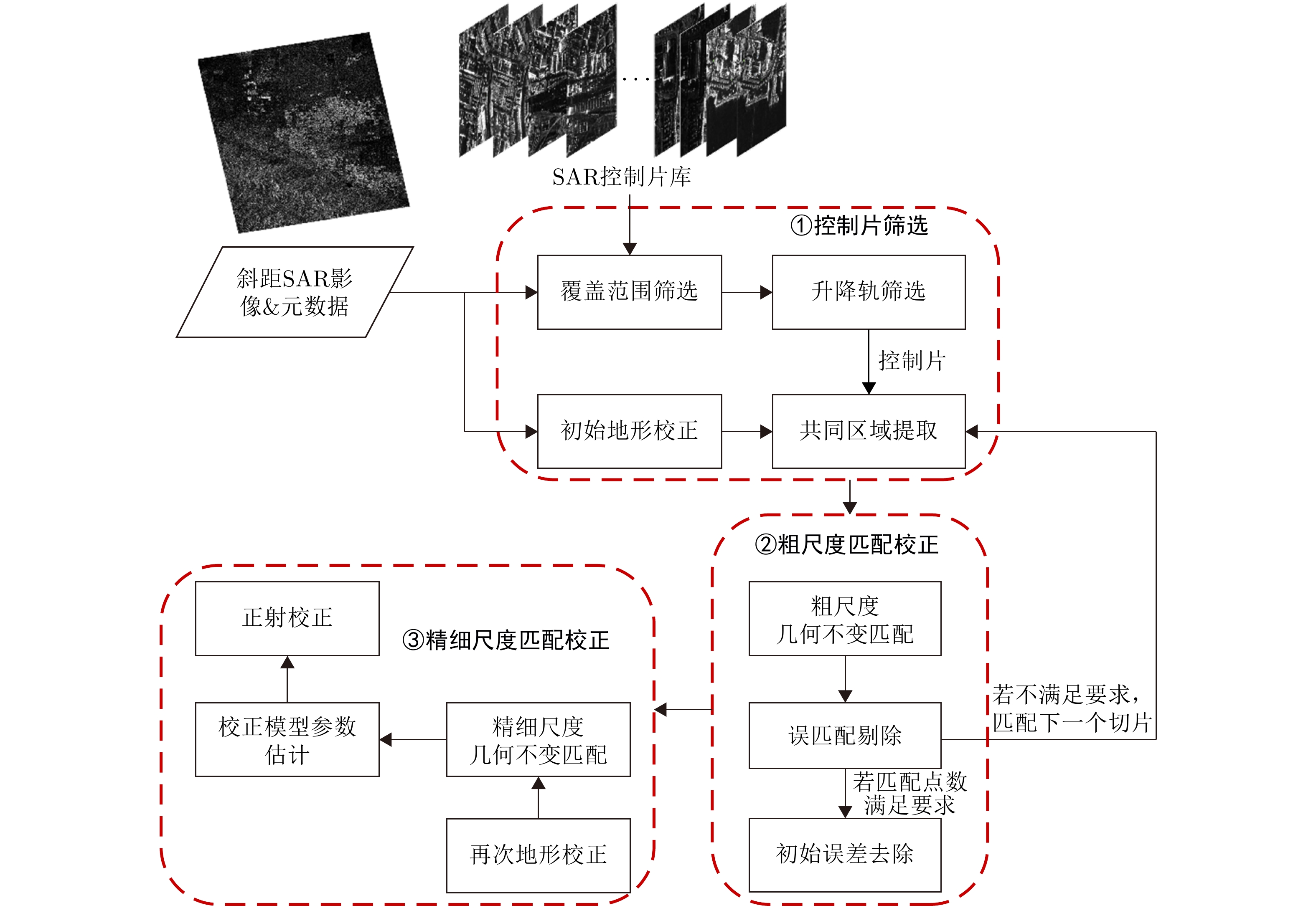
图 4 基于控制片的SAR影像正射校正算法流程图
Figure 4. Flowchart of the orthorectification algorithm for SAR imagery based on control chips
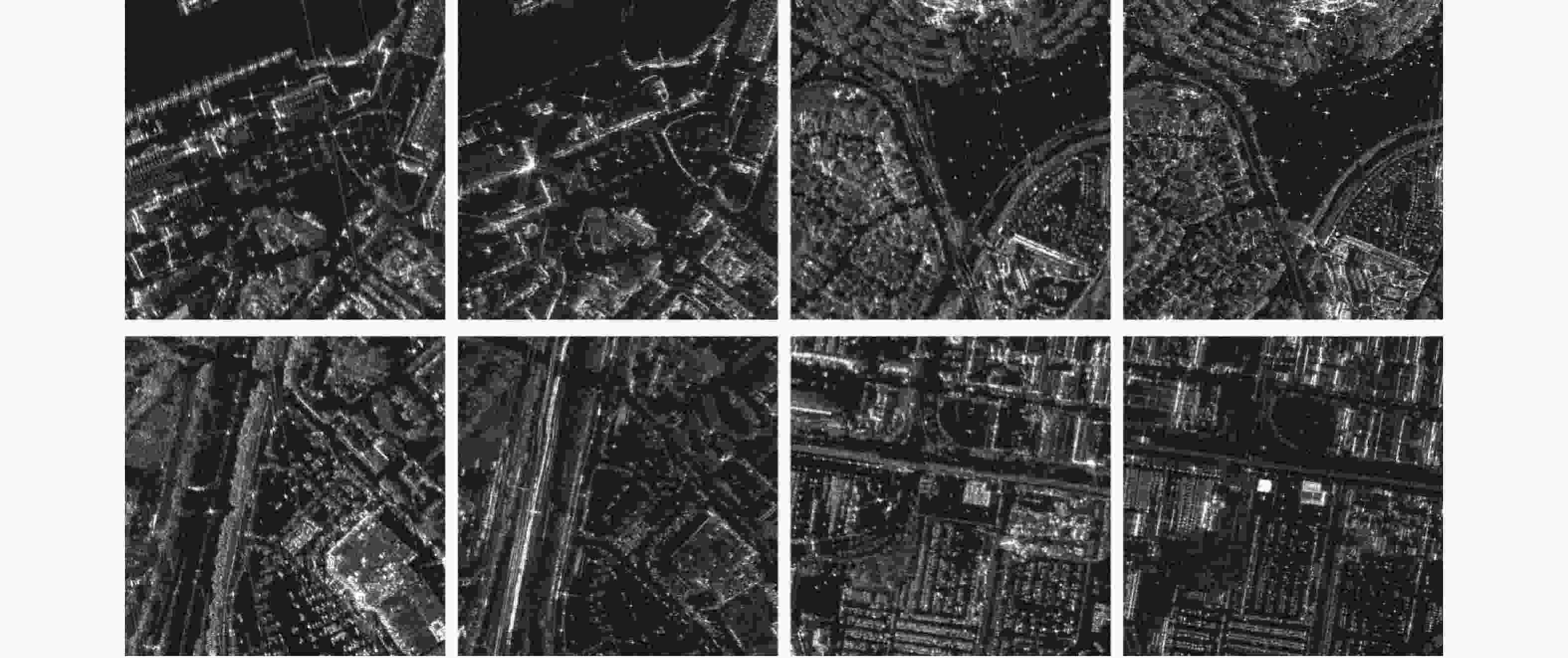
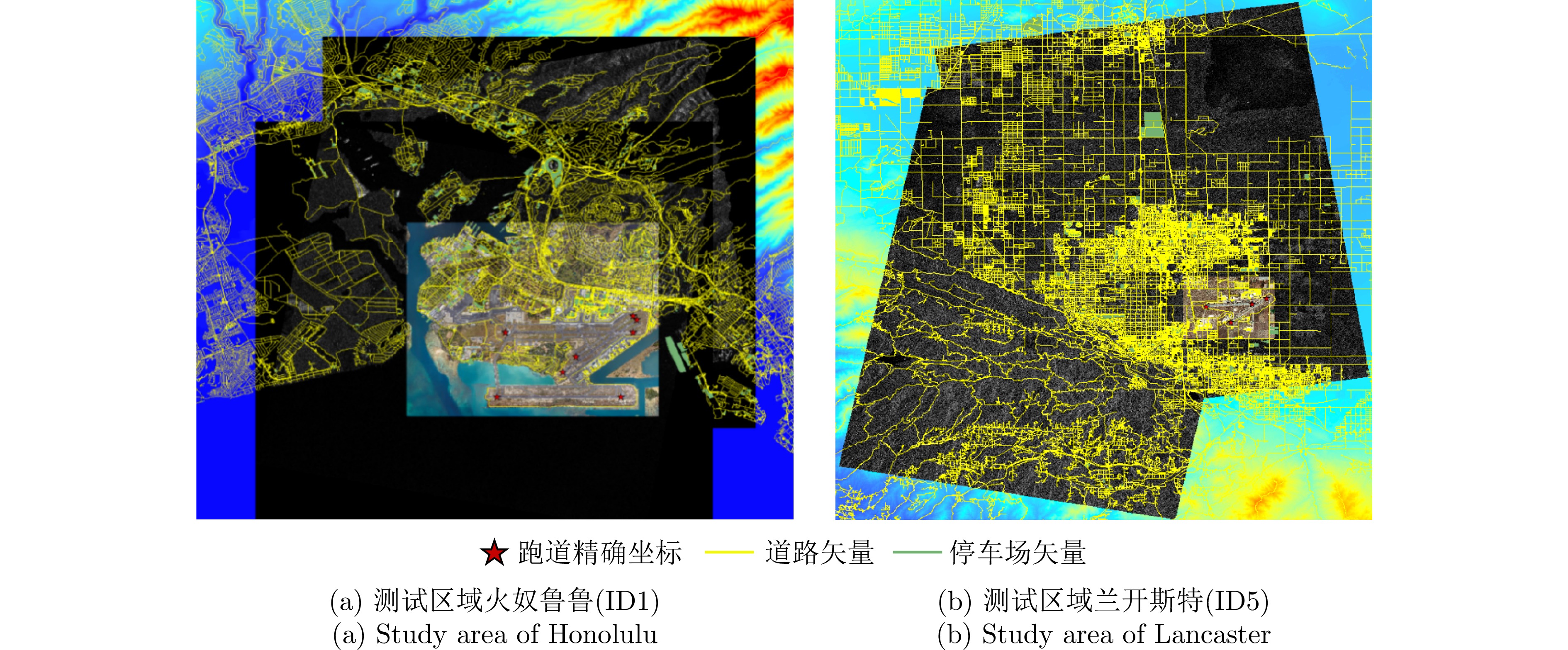
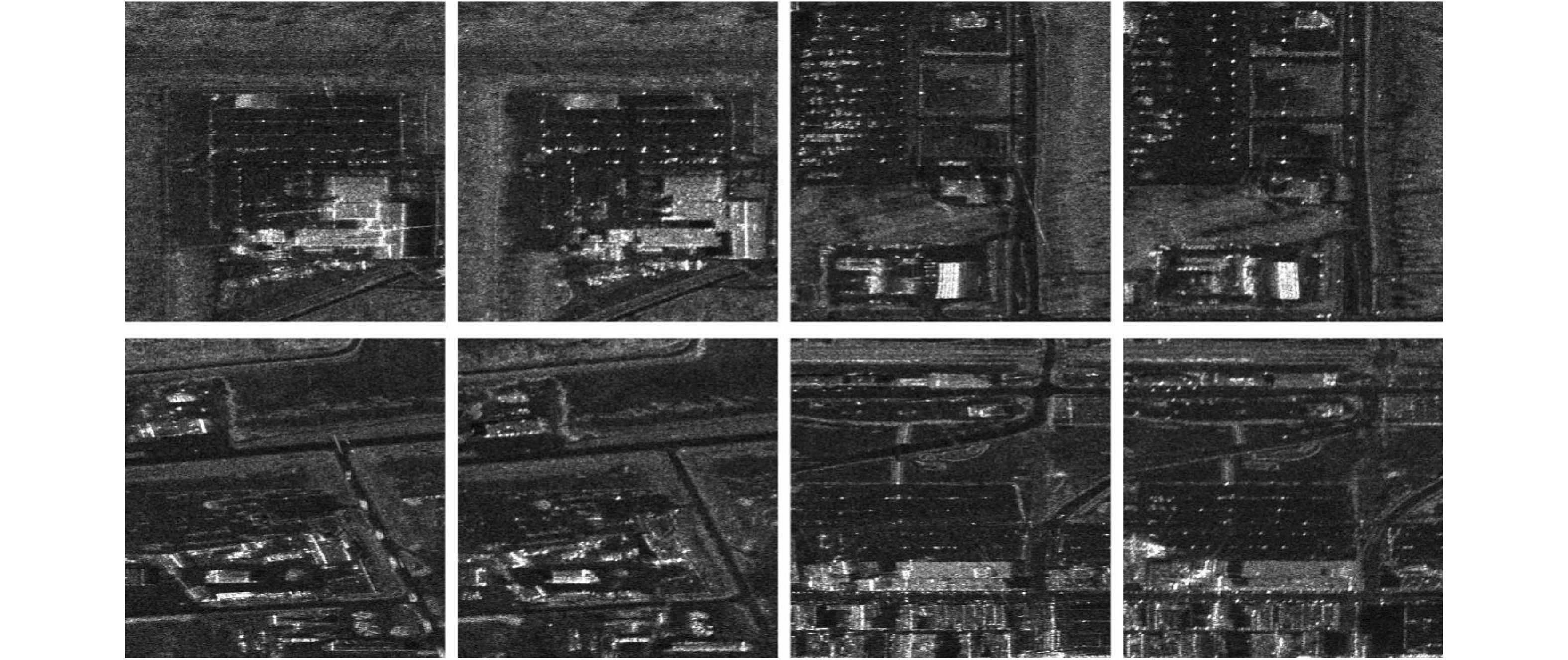
图 5 火奴鲁鲁(ID1)的升降轨控制片结果
Figure 5. Results of control chips for ascending and descending orbits in test area ID1

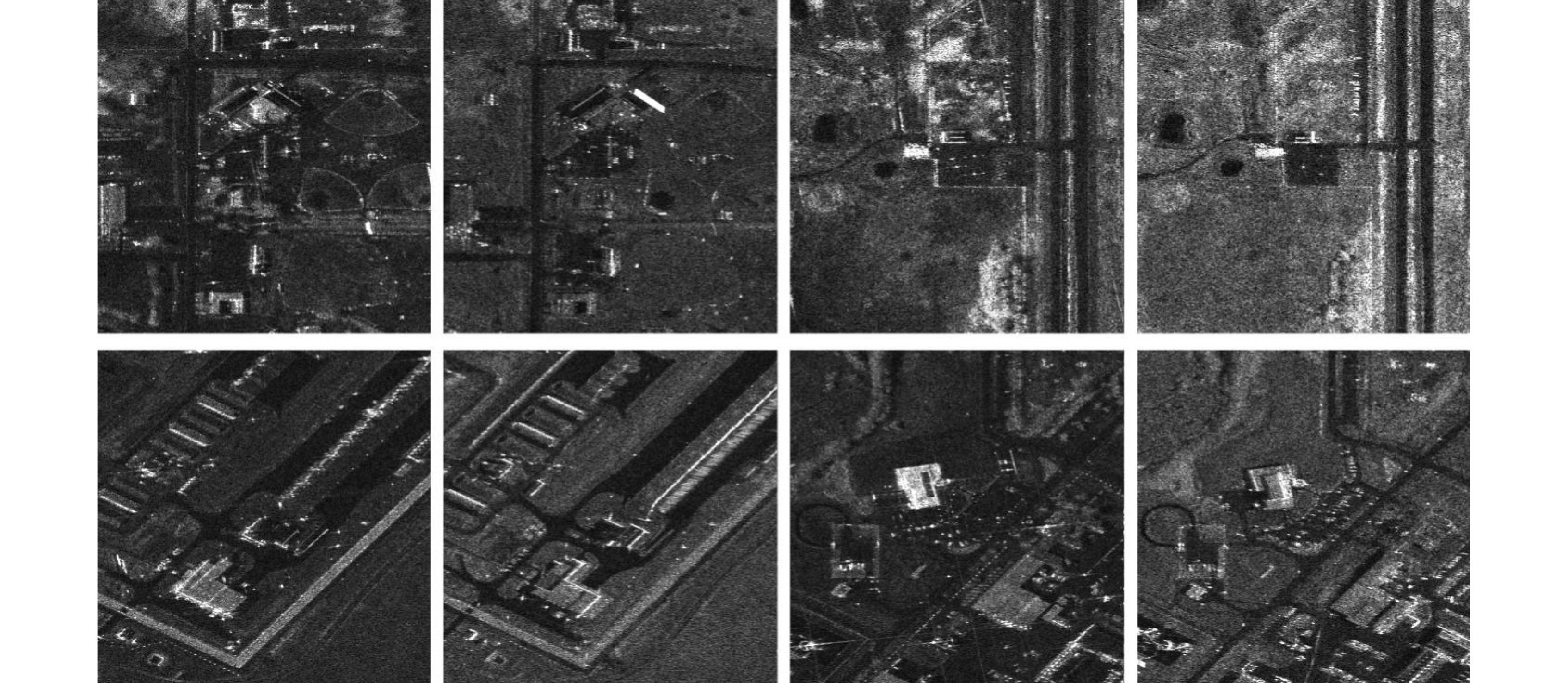
图 6 安克雷奇(ID2)的升降轨控制片结果
Figure 6. Results of control chips for ascending and descending orbits in test area ID2
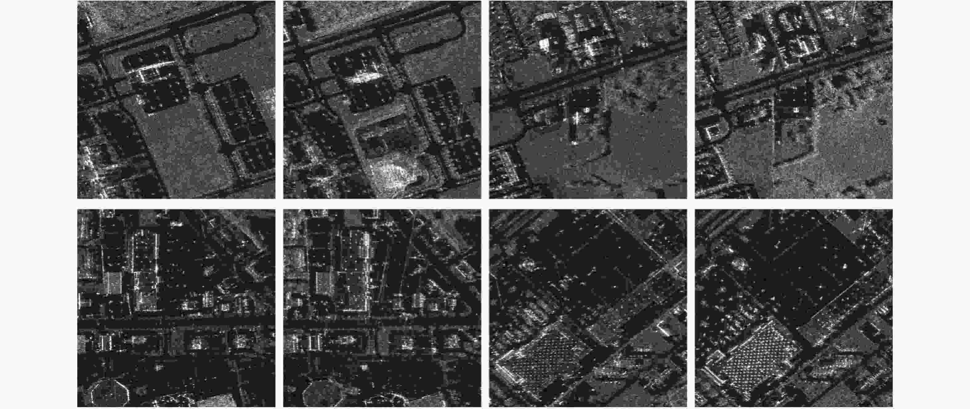
图 7 马歇尔(ID3)的升降轨控制片结果
Figure 7. Results of control chips for ascending and descending orbits in test area ID3
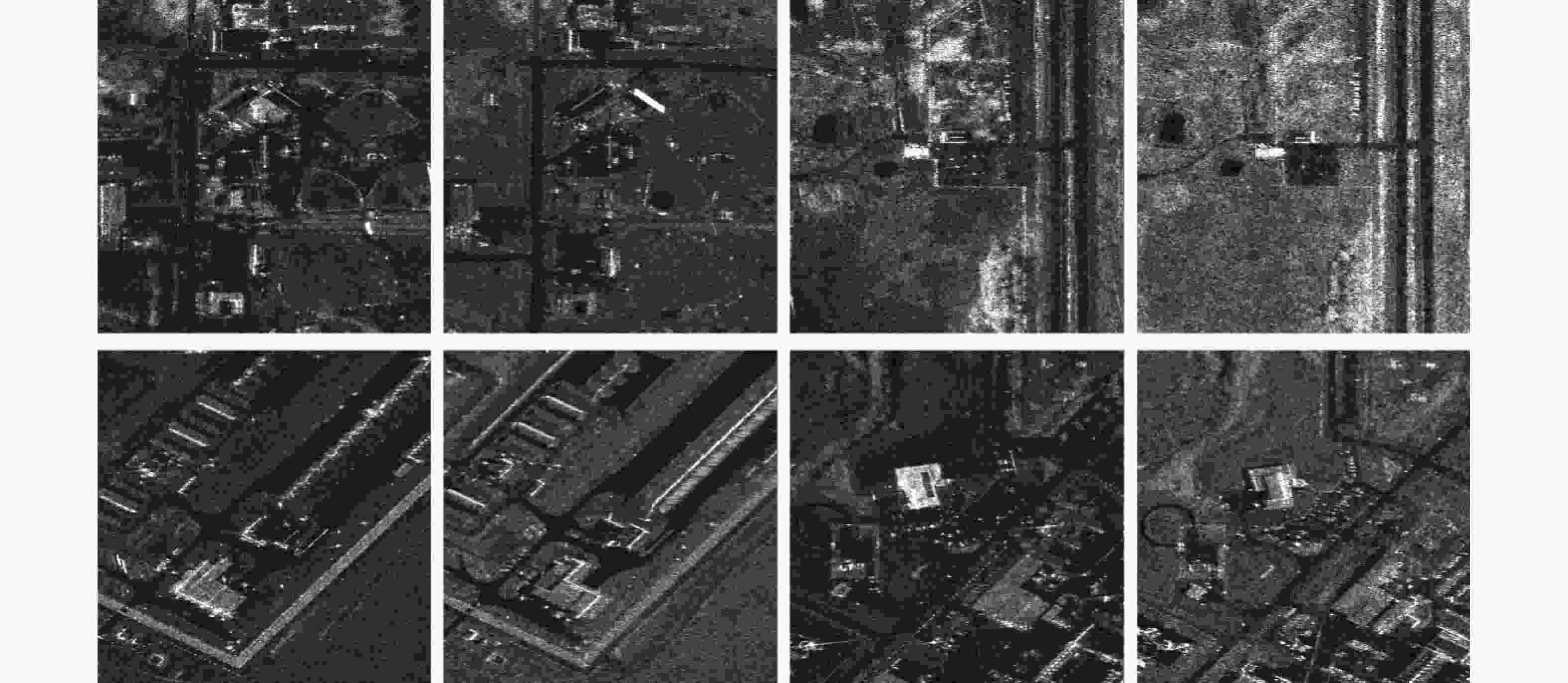
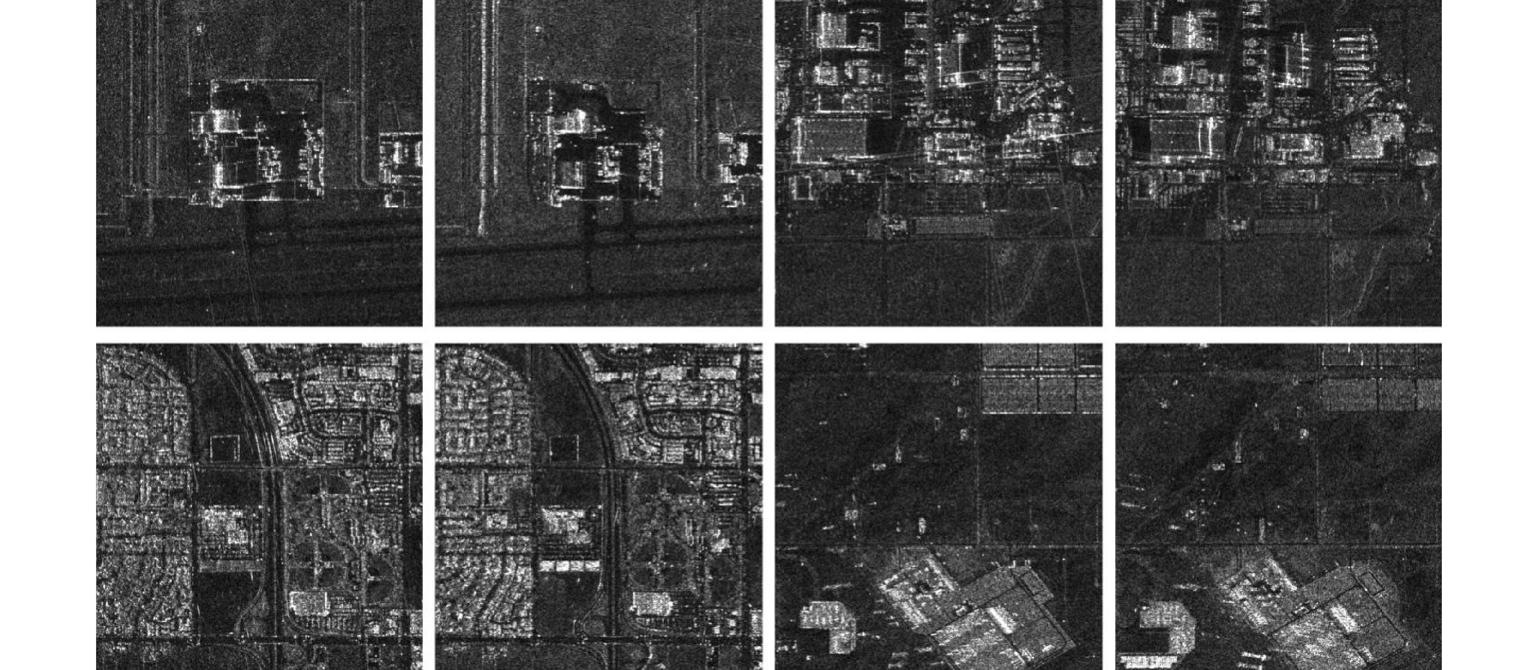
图 8 萨斯卡通(ID4)的升降轨控制片结果
Figure 8. Results of control chips for ascending and descending orbits in test area ID4
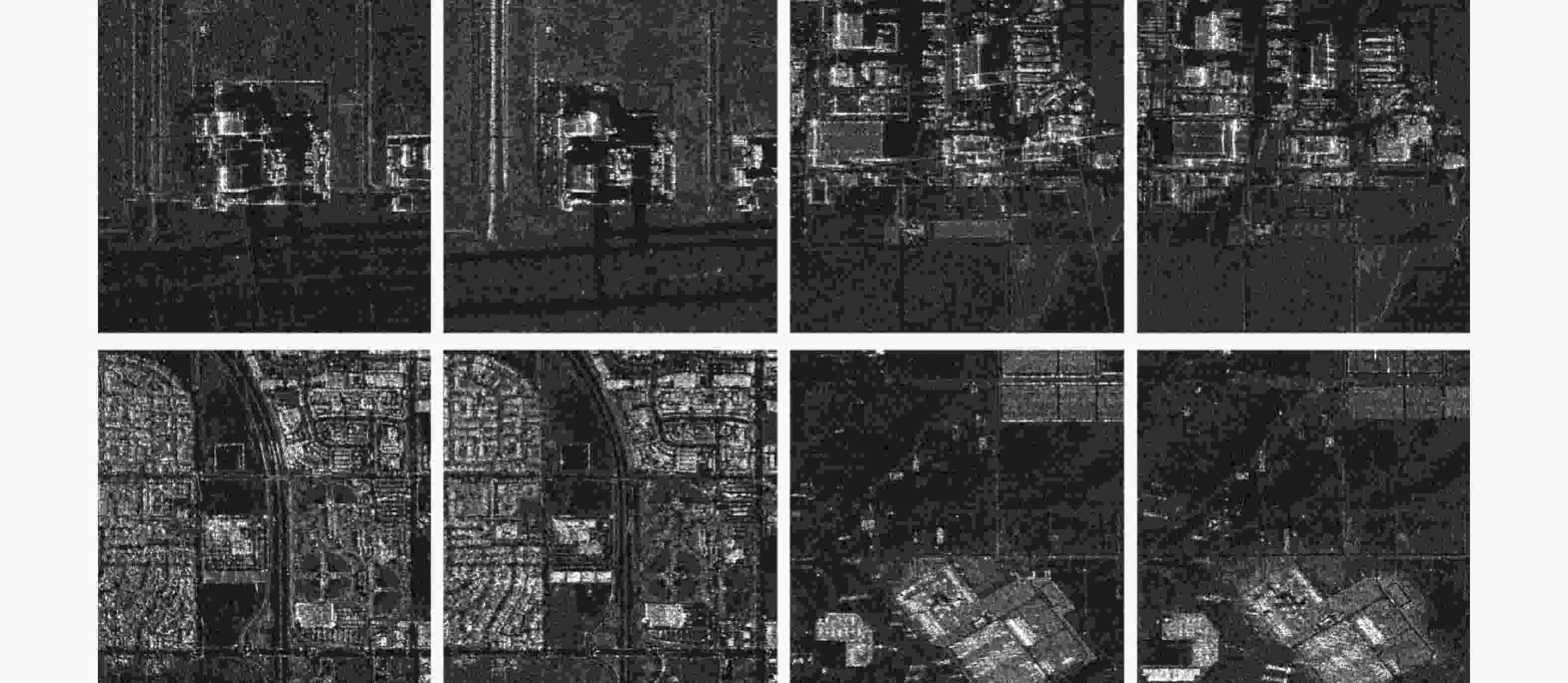
图 9 兰开斯特(ID5)的升降轨控制片结果
Figure 9. Results of control chips for ascending and descending orbits in test area ID5
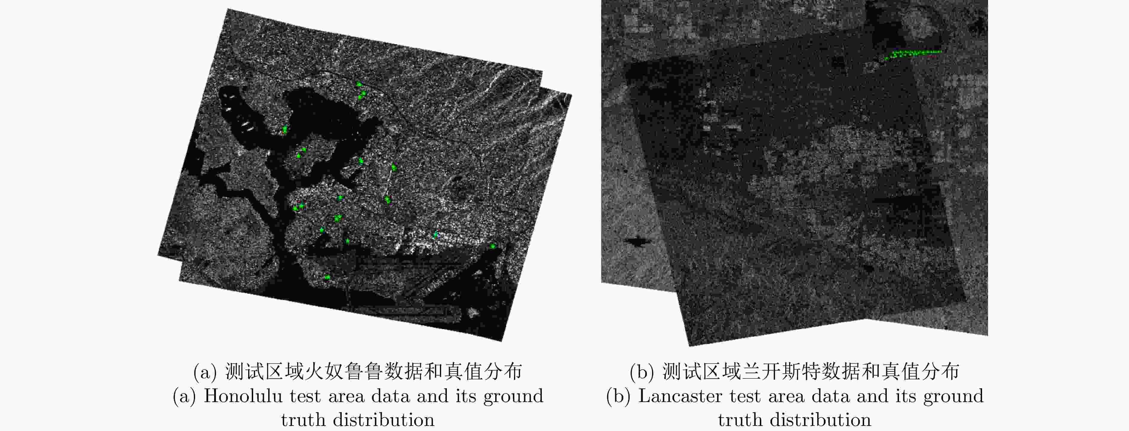
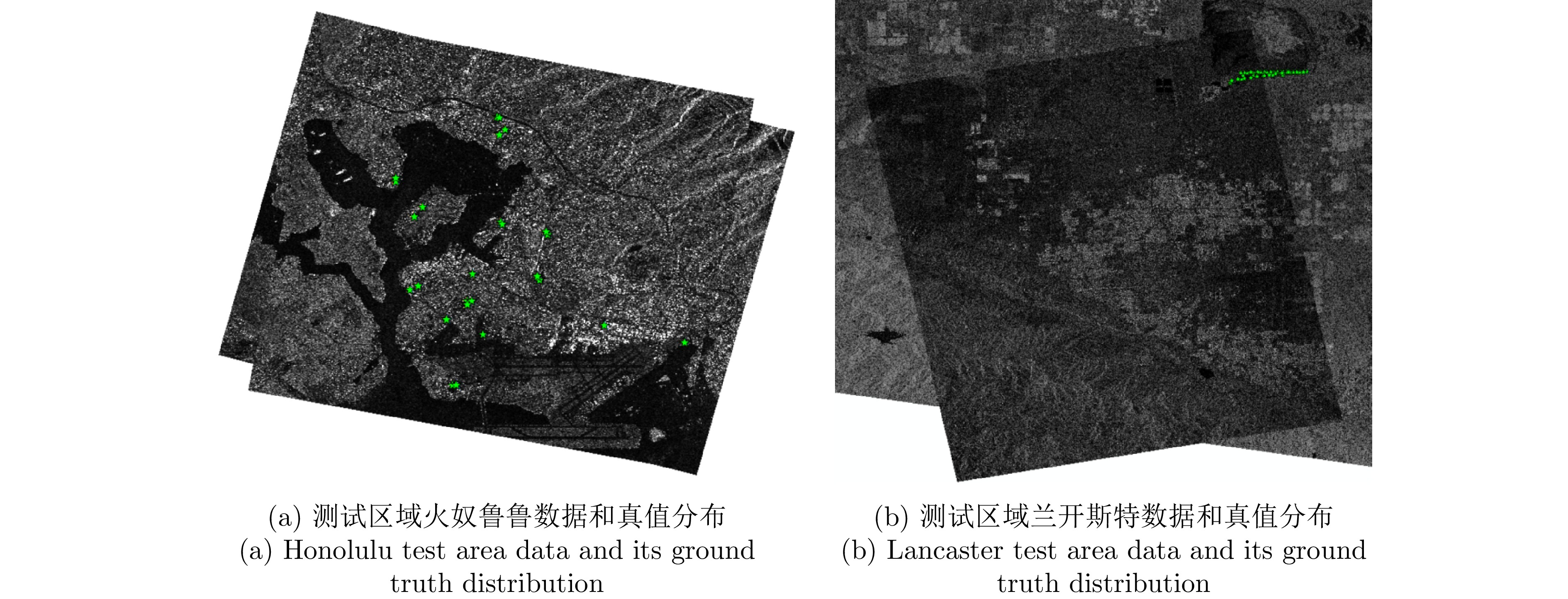
图 10 待校正的SAR影像和用于评估的真值点位
Figure 10. SAR images to be rectified and ground truth points for evaluation
表 1 测试区域和众源数据信息
Table 1. The study area and multi-sourced data information
测试区域 开源机场
跑道道路和
停车场矢量DEM 谷歌光学
影像高分三号C波段立体SAR影像 火奴鲁鲁(ID1) Airport data
(FAA)OpenStreetMap ≈10 m
USGS≈0.3 m
RGB聚束/降轨/右侧视/38.2°/0.56 m/0.34 m 聚束/升轨/右侧视/36.7°/0.56 m/0.34 m 安克雷奇(ID2) 聚束/降轨/右侧视/35.4°/0.56 m/0.34 m 聚束/升轨/右侧视/34.5°/0.56 m/0.33 m 马歇尔(ID3) 聚束/降轨/右侧视/32.3°/0.56 m/0.33 m 聚束/升轨/右侧视/27.7°/0.56 m/0.31 m 萨斯卡通(ID4) 聚束/降轨/右侧视/26.6°/0.56 m/0.31 m 聚束/升轨/右侧视/39.1°/0.56 m/0.34 m 兰开斯特(ID5) 条带/降轨/右侧视/28.4°/1.12 m/1.73 m 条带/升轨/右侧视/42.5°/1.12 m/1.70 m  下载: 导出CSV
表 2 测试区域提取到的控制点精度评估结果以及控制点数量
Table 2. Accuracy assessment results of extracted control points in the test areas, and the number of control points
测试区域 平面精度RMSEh 高程精度RMSEv NGCP 火奴鲁鲁(ID1) 0.85 m 0.47 m 124 安克雷奇(ID2) 0.87 m 0.26 m 26 马歇尔(ID3) 0.69 m 0.31 m 239 萨斯卡通(ID4) 0.55 m 0.26 m 53 兰开斯特(ID5) 1.35 m 1.02 m 155
下载: 导出CSV
表 3 待校正的SAR影像成像参数信息
Table 3. The imaging parameter information of the SAR image to be rectified
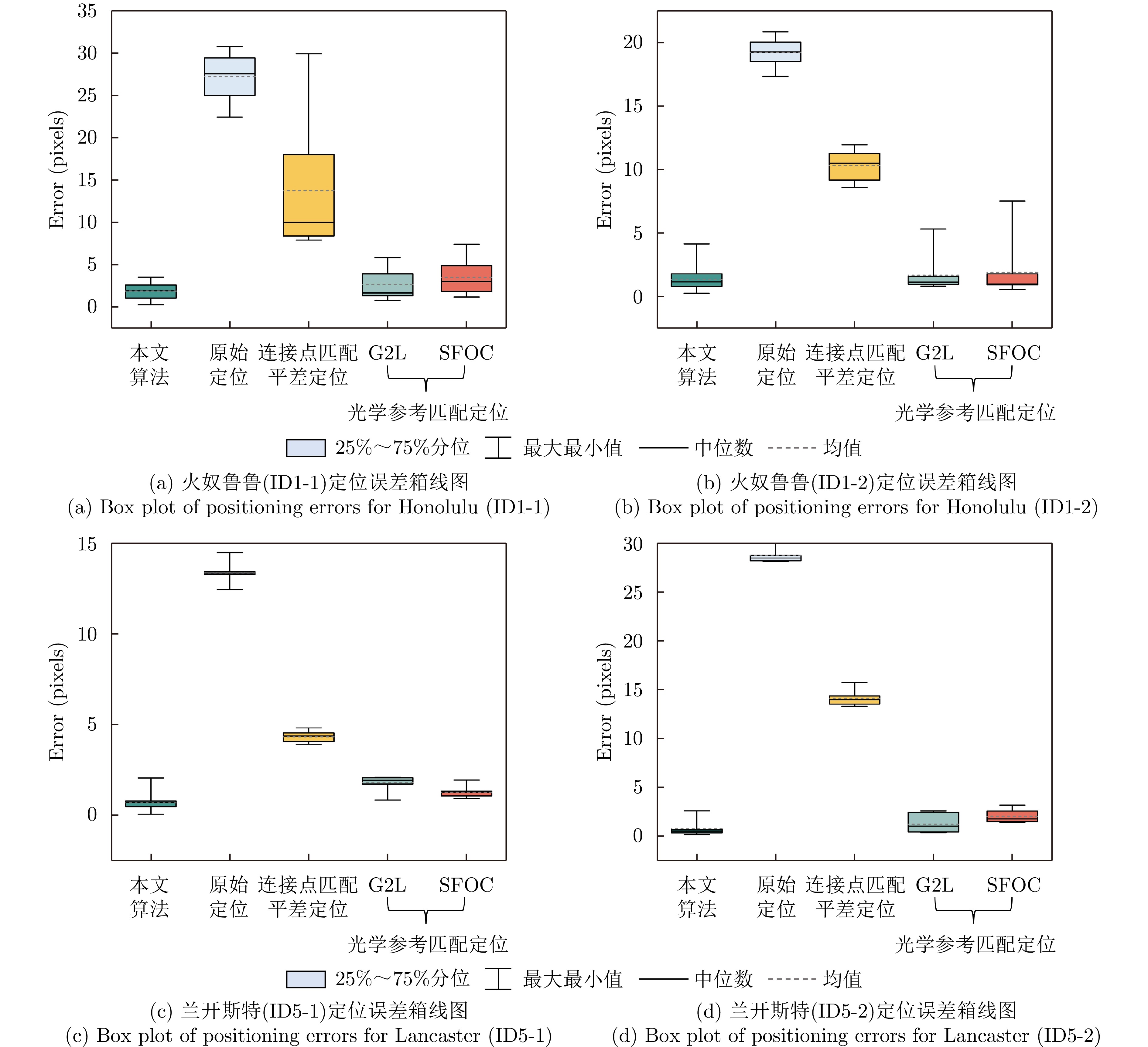
测试区域 卫星型号 成像模式 成像视角(°) 轨道/侧视方向 采样间隔(m) 影像尺寸(像素) 评估真值 火奴鲁鲁(ID1-1) 高分三号 聚束 31.8 降轨/右 0.56/0.33 12148 ×32226 机载激光点云 火奴鲁鲁ID1-2) 聚束 39.6 降轨/左 0.56/0.34 16672 ×29190 兰开斯特(ID5-1) 超精细条带 28.4 升轨/右 1.12/1.73 14297 ×21550 角反射器 兰开斯特(ID5-2) 精细条带II 39.2 降轨/右 2.25/4.82 32026 ×24656
下载: 导出CSV
表 4 所有算法在4组测试影像上的定位误差(RMSE,像素)以及平均处理时间
Table 4. Positioning errors (RMSE, pixels) and average processing time of all algorithms on four sets of test images
测试区域 火奴鲁鲁(ID1-1) 火奴鲁鲁(ID1-2) 兰开斯特(ID5-1) 兰开斯特(ID5-2) 平均处理时间(s) 本文算法 2.07 1.55 1.09 0.82 72.3 基于SAR原始定位参数和DEM校正 27.37 19.24 28.77 13.37 14.5 升降轨SAR连接点匹配平差校正 15.39 10.36 14.16 4.35 65.9 SFOC24 4.08 2.78 2.15 1.31 57.2 G2L18 3.18 2.12 1.50 1.83 85.9 注:加粗数值表示本文算法定位误差。
下载: 导出CSV
表 5 消融实验对比结果(包括控制点平面精度(m)和高程精度(m),w/o代表去除)
Table 5. The comparison results of ablation study (including positioning error (m) and elevation error (m))
消融方法 本文
算法w/o 机场跑道
坐标w/o 连接点
平差w/o 立体
交会解算平面精度RMSEh 0.85 5.19 1.92 1.68 高程精度RMSEv 0.47 1.44 1.35 1.52 注:加粗数值表示最优。
下载: 导出CSV
-
[1] 仇晓兰, 胡玉新, 上官松涛, 等. 遥感卫星大数据高精度一体化处理技术[J]. 大数据, 2022, 8(2): 15–27. doi: 10.11959/j.issn.2096-0271.2022013.QIU Xiaolan, HU Yuxin, SHANGGUAN Songtao, et al. Remote sensing satellite big data high-precision integration processing technology[J]. Big Data Research, 2022, 8(2): 15–27. doi: 10.11959/j.issn.2096-0271.2022013. [2] 向俞明, 滕飞, 王林徽, 等. 基于快速异源配准的高分辨率SAR影像海岛区域正射校正[J]. 雷达学报(中英文), 2024, 13(4): 866–884. doi: 10.12000/JR24022.XIANG Yuming, TENG Fei, WANG Linhui, et al. Orthorectification of high-resolution SAR images in island regions based on fast multimodal registration[J]. Journal of Radars, 2024, 13(4): 866–884. doi: 10.12000/JR24022. [3] EINEDER M, MINET C, STEIGENBERGER P, et al. Imaging geodesy—toward centimeter-level ranging accuracy with TerraSAR-X[J]. IEEE Transactions on Geoscience and Remote Sensing, 2011, 49(2): 661–671. doi: 10.1109/TGRS.2010.2060264. [4] RAGGAM H, PERKO R, GUTJAHR K, et al. Accuracy assessment of 3D point retrieval from TerraSAR-X data sets[C]. 8th European Conference on Synthetic Aperture Radar, Aachen, Germany, 2010: 1–4. [5] NITTI D O, MOREA A, NUTRICATO R, et al. Automatic GCP extraction with high resolution COSMO-SkyMed products[C]. SPIE 10003, SAR Image Analysis, Modeling, and Techniques XVI, Edinburgh, United Kingdom, 2016: 1000302. doi: 10.1117/12.2241281. [6] MONTAZERI S, GISINGER C, EINEDER M, et al. Automatic detection and positioning of ground control points using TerraSAR-X multiaspect acquisitions[J]. IEEE Transactions on Geoscience and Remote Sensing, 2018, 56(5): 2613–2632. doi: 10.1109/TGRS.2017.2769078. [7] KRAUß T, KURZ F, and RUNGE H. Automatic pole detection in aerial and satellite imagery for precise image registration with SAR ground control points[J]. ISPRS Annals of the Photogrammetry, Remote Sensing and Spatial Information Sciences, 2022, V–1–2022: 85–91. doi: 1 0.5194/isprs-annals-V-1-2022-85-2022. [8] CHANDELIER L, COEURDEVEY L, BOSCH S, et al. A worldwide 3D GCP database inherited from 20 years of massive multi-satellite observations[J]. ISPRS Annals of the Photogrammetry, Remote Sensing and Spatial Information Sciences, 2020, V–2–2020: 15–23. doi: 10.5194/isprs-annals-V-2-2020-15-2020. [9] XI Mengrong, FENG Yongjiu, LEI Zhenkun, et al. Geometric calibration of large-scale SAR images using wind turbines as ground control points[J]. International Journal of Digital Earth, 2024, 17(1): 2385080. doi: 10.1080/17538947.2024.2385080. [10] 王密, 韦钰, 杨博, 等. ICESat-2/ATLAS全球高程控制点提取与分析[J]. 武汉大学学报: 信息科学版, 2021, 46(2): 184–192. doi: 10.13203/j.whugis20200531.WANG Mi, WEI Yu, YANG Bo, et al. Extraction and analysis of global elevation control points from ICESat-2/ATLAS data[J]. Geomatics and Information Science of Wuhan University, 2021, 46(2): 184–192. doi: 10.13203/j.whugis20200531. [11] LI Binbin, XIE Huan, LIU Shijie, et al. A high-quality global elevation control point dataset from ICESat-2 altimeter data[J]. International Journal of Digital Earth, 2024, 17(1): 2361724. doi: 10.1080/17538947.2024.2361724. [12] 余洋, 靳国旺, 熊新, 等. 多策略ATLAS数据优选与影像匹配相结合的SAR高程控制点提取[J]. 雷达学报, 2023, 12(1): 64–75. doi: 10.12000/JR22134.YU Yang, JIN Guowang, XIONG Xin, et al. SAR elevation control point extraction combining multistrategy ATLAS data preference and image matching[J]. Journal of Radars, 2023, 12(1): 64–75. doi: 10.12000/JR22134. [13] HUBER M, WESSEL B, and ROTH A. The TerraSAR-X orthorectification service and its benefit for land use applications[C]. 2006 IEEE International Symposium on Geoscience and Remote Sensing, Denver, USA, 2006: 1922–1925. doi: 10.1109/IGARSS.2006.497. [14] MERKLE N, LUO Wenjie, AUER S, et al. Exploiting deep matching and SAR data for the geo-localization accuracy improvement of optical satellite images[J]. Remote Sensing, 2017, 9(6): 586. doi: 10.3390/rs9060586. [15] JIAO Niangang, WANG Feng, YOU Hongjian, et al. A generic framework for improving the geopositioning accuracy of multi-source optical and SAR imagery[J]. ISPRS Journal of Photogrammetry and Remote Sensing, 2020, 169: 377–388. doi: 10.1016/j.isprsjprs.2020.09.017. [16] CHENG Qian, WANG Taoyang, LI Xin, et al. Geometric positioning accuracy improvement method of micro SAR satellites with large positioning errors[J]. IEEE Journal of Selected Topics in Applied Earth Observations and Remote Sensing, 2024, 17: 14949–14964. doi: 10.1109/JSTARS.2024.3430847. [17] 张祖勋, 段延松, 陶鹏杰. 从控制点到控制片[J]. 武汉大学学报: 信息科学版, 2023, 48(11): 1715–1723. doi: 10.13203/j.whugis20230373.ZHANG Zuxun, DUAN Yansong, and TAO Pengjie. From ground control point to digital control photo[J]. Geomatics and Information Science of Wuhan University, 2023, 48(11): 1715–1723. doi: 10.13203/j.whugis20230373. [18] XIANG Yuming, WANG Xuanqi, WANG Feng, et al. A global-to-local algorithm for high-resolution optical and SAR image registration[J]. IEEE Transactions on Geoscience and Remote Sensing, 2023, 61: 5215320. doi: 10.1109/TGRS.2023.3309855. [19] XIANG Yuming, JIAO Niangang, LIU Rui, et al. A geometry-aware registration algorithm for multiview high-resolution SAR images[J]. IEEE Transactions on Geoscience and Remote Sensing, 2022, 60: 5234818. doi: 10.1109/TGRS.2022.3205382. [20] GRODECKI J D and DIAL G. Block adjustment of high-resolution satellite images described by rational polynomials[J]. Photogrammetric Engineering & Remote Sensing, 2003, 69(1): 59–68. doi: 10.14358/PERS.69.1.59. [21] FRASER C S and HANLEY H B. Bias compensation in rational functions for IKONOS satellite imagery[J]. Photogrammetric Engineering & Remote Sensing, 2003, 69(1): 53–57. doi: 10.14358/PERS.69.1.53. [22] 徐凯. 星载SAR高精度几何处理方法研究及应用[D]. [博士论文], 武汉大学, 2020. doi: 10.27379/d.cnki.gwhdu.2020.002502.XU Kai. Research on high precision geometric processing methods and application of spaceborne SAR[D]. [Ph.D. dissertation], Wuhan University, 2020. doi: 10.27379/d.cnki.gwhdu.2020.002502. [23] WANG Jian, CHAI Huiming, LI Xiaoshuai, et al. Improving mountainous DSM accuracy through an innovative opposite-side radargrammetry algorithm[J]. IEEE Journal of Selected Topics in Applied Earth Observations and Remote Sensing, 2025, 18: 6641–6653. doi: 10.1109/JSTARS.2025.3543430. [24] YE Yuanxin, ZHU Bai, TANG Tengfeng, et al. A robust multimodal remote sensing image registration method and system using steerable filters with first-and second-order gradients[J]. ISPRS Journal of Photogrammetry and Remote Sensing, 2022, 188: 331–350. doi: 10.1016/j.isprsjprs.2022.04.011. -


计量
- 文章访问数:
- HTML全文浏览量:
- PDF下载量:
- 被引次数: 0

