
 作者中心
作者中心 专家审稿
专家审稿 责编办公
责编办公 编辑办公
编辑办公
Estimation of InSAR Time-series Deformation for Soft-soil Highways Considering Cyclic Loading
-
摘要: 车辆长期循环荷载是造成公路工后沉降不可忽视的因素。目前,用于软土公路形变监测的干涉合成孔径雷达(InSAR)形变模型往往忽略了循环荷载的贡献,多为一种或几种纯经验函数组合而成,物理意义不够明确。该文提出一种顾及循环荷载的软土地基公路时序形变估计方法(IRTM),这一方法针对InSAR形变建模和参数估计算法分别进行改进。在形变建模环节,以描述软土形变蠕变特性的Maxwell流变模型为基础模型,引用附加动应力模型以描述循环荷载导致的塑性变形时序演化规律,并联合热膨胀模型表征路基和桥梁受温度影响的热膨胀效应分量,以更合理地解译形变估计结果;在参数估计环节,提出一种基于遗传算法(GA)与列文伯格马尔夸特算法(LM)串行的参数估计方法,对GA获取的初值进行二次优化,提升求解效率和精度。分别开展了模拟和真实数据实验对所提方法进行验证。模拟实验发现,在施加±0.5 rad 噪声时,模型参数估计值的相对误差均低于6%。真实数据选取了北京至平谷高速公路作为研究区域,获取了其在2012年1月22日到2014年7月1日期间的时序形变。实验发现,形变累积达–140 mm,软土地基段形变贡献以流变分量为主,约占76%;而位于道路交叉段则以循环荷载分量为主,约占81%。分别从建模精度、有限元分析和交叉验证3方面验证该文结果的精度。建模精度利用单一Maxwell模型和传统线性模型生成结果对比,分别提高了44.4%和49.6%;利用有限元分析(FEA)方法验证真实实验获取的形变精度,得出该文方法获取的变形曲线与FEA在不同轴载下产生的变形一致,最大标准偏差仅为1.8 mm;与已有研究的交叉验证结果表明,该文所得形变速率外部精度为±1.4mm/yr,进一步证实了该文方法用于循环荷载作用下的公路工后形变估计和解译是可靠的,可为公路稳定性控制提供参考。Abstract: Long-term cyclic loading by vehicles is a non-negligible contributor to post-work settlement of highways. Current Interferometric Synthetic Aperture Radar (InSAR) deformation models used for monitoring the deformation of soft-soil highways generally neglect the contribution of cyclic loading. The InSAR time-series deformation models used for monitoring highway deformation are typically combinations of one or several purely empirical functions, which lack clarity in physical significance and overlook the impact of cyclic loading on settlement. Herein, a method for estimating the deformation of soft-ground highways that accounts for cyclic loading is proposed (Improved InSAR Model considering both the Rheological Properties and the Traffc Loading, IRTM). The method improves InSAR deformation modeling and the parameter estimation algorithms. In the deformation modeling, the Maxwell rheological model, which describes the deformation and creep characteristics of soft soil, serves as the base model for InSAR modeling. An additional dynamic stress model was incorporated to describe the plastic deformation caused by cyclic loading, which was combined with a thermal expansion model to characterize the thermal expansion component of the road base and bridge affected by temperature. This combination provided a more reasonable interpretation of the deformation estimation data. For parameter estimation, a method based on a Genetic Algorithm (GA) and a parameter estimation algorithm was proposed. In particular, a parameter estimation method combining GA and the Levenberg-Marquardt (LM) algorithm was developed, where the initial value obtained by GA was further optimized by LM to enhance the solving efficiency and accuracy. The proposed method was validated through simulation and experiments employing real data. The simulation revealed that the relative errors of the model parameter estimates were all below 6% when ±0.5 rad noise was applied. Real data from the selected study area, i.e., the Beijing-Pinggu Expressway, were utilized, and the time-series deformations from 22 January 2012 to 1 July 2014 were obtained. The results show that the cumulative deformation reached −140 mm, where the rheological component of the soft-ground section was the dominant contributor to deformation, accounting for approximately 76%, whereas the cyclic through-load component was dominant at road intersections, accounting for 81%. Compared with single Maxwell and traditional linear models, the modeling accuracy of the developed method was improved by 44.4% and 49.6%, respectively. Finite Element Analysis (FEA) was used to verify the deformation accuracy obtained from real experiments. The deformation curves generated using the developed method were consistent with those produced by FEA under different axle loads, with a maximum standard deviation of only 1.8 mm. Cross-validation against existing studies showed that the external accuracy of the deformation rate obtained in this study was ±1.4 mm/yr, further confirming the reliability of the developed method for estimating and interpreting the post-work deformation of highways under cyclic loading. This method can provide a reference for controlling the stability of highways.
-
Key words:
- Interferometric Synthetic Aperture Radar (InSAR) /
- Cyclic loading /
- Deformation /
- Soft-soil /
- Highways
-
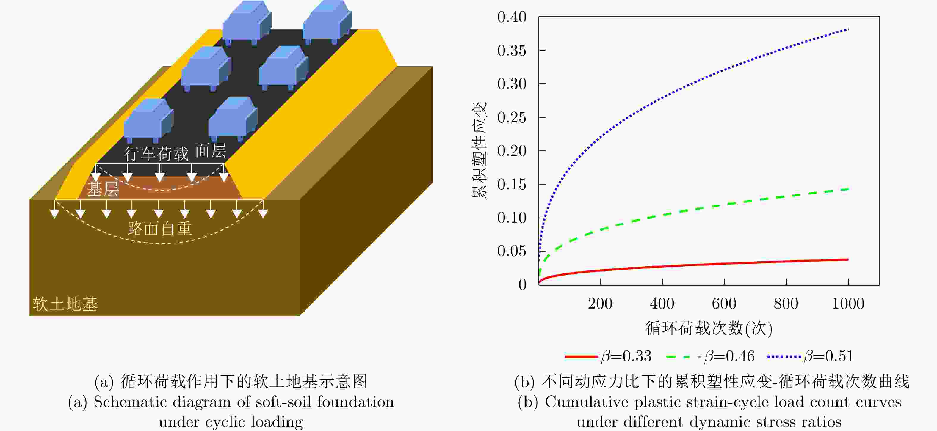
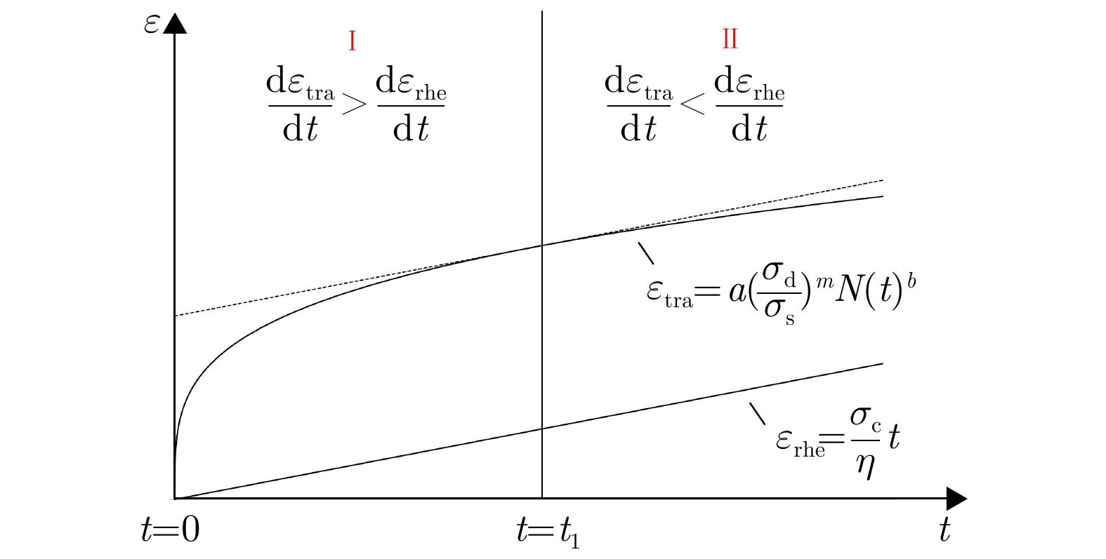
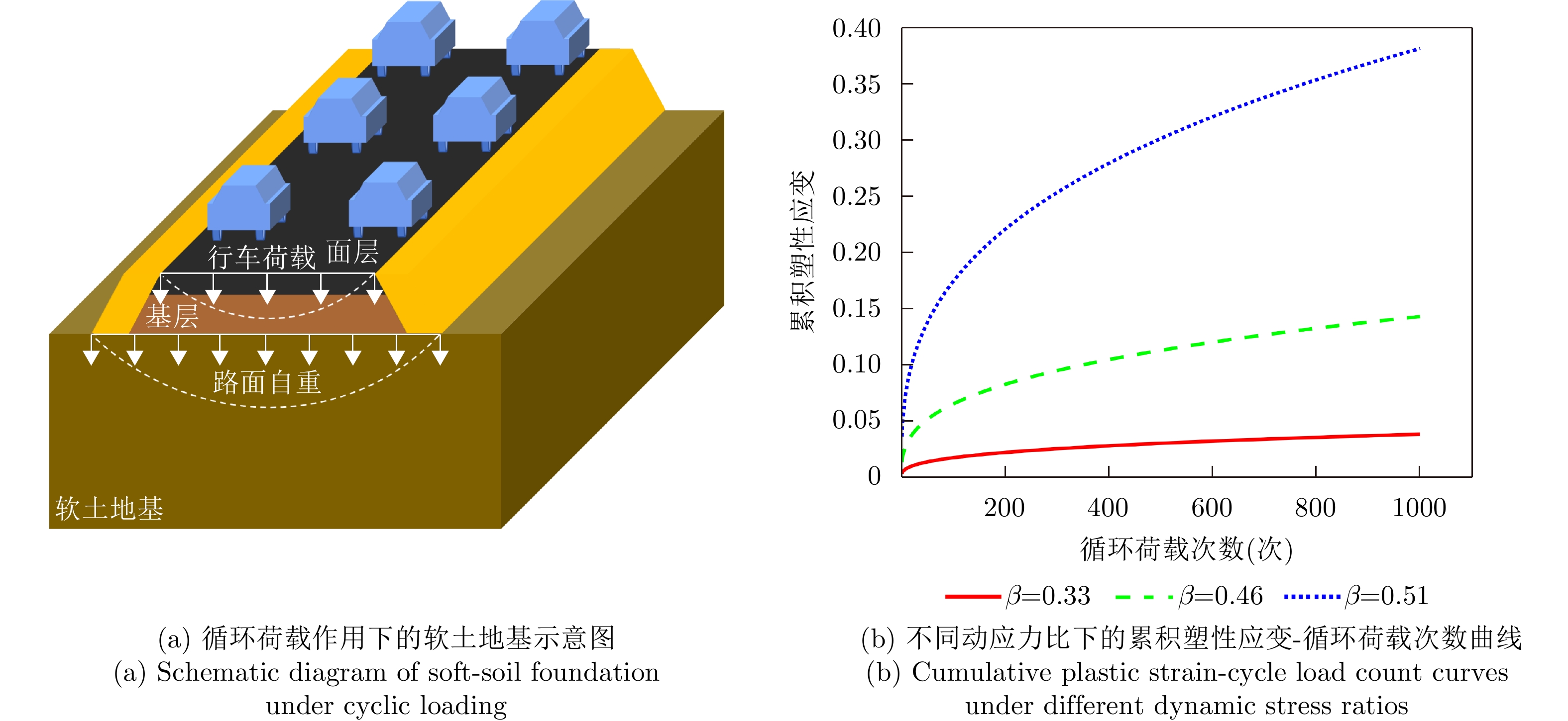
图 1 循环荷载作用下的软土路基变形机制
Figure 1. Deformation mechanism of soft-soil roadbed under cyclic loading

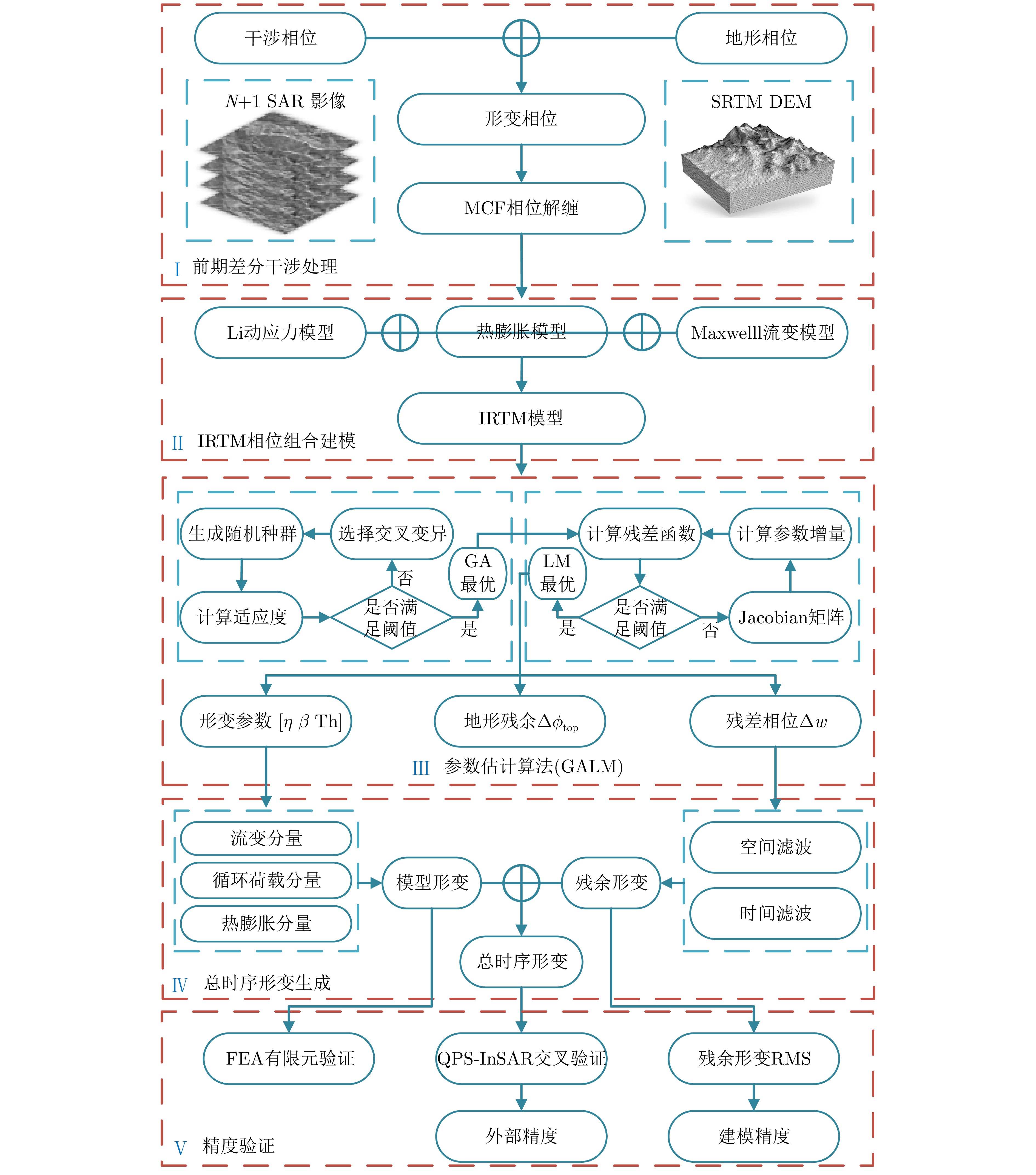
图 2 顾及循环荷载的软土地基公路时序InSAR估计方法流程
Figure 2. General flow of time-series InSAR estimation for soft-soil highways considering cyclic loading

图 8 总时间序列沉降(参考图像日期:
20120122 )Figure 8. Time-series deformation over the highway (reference image date:
20120122 )
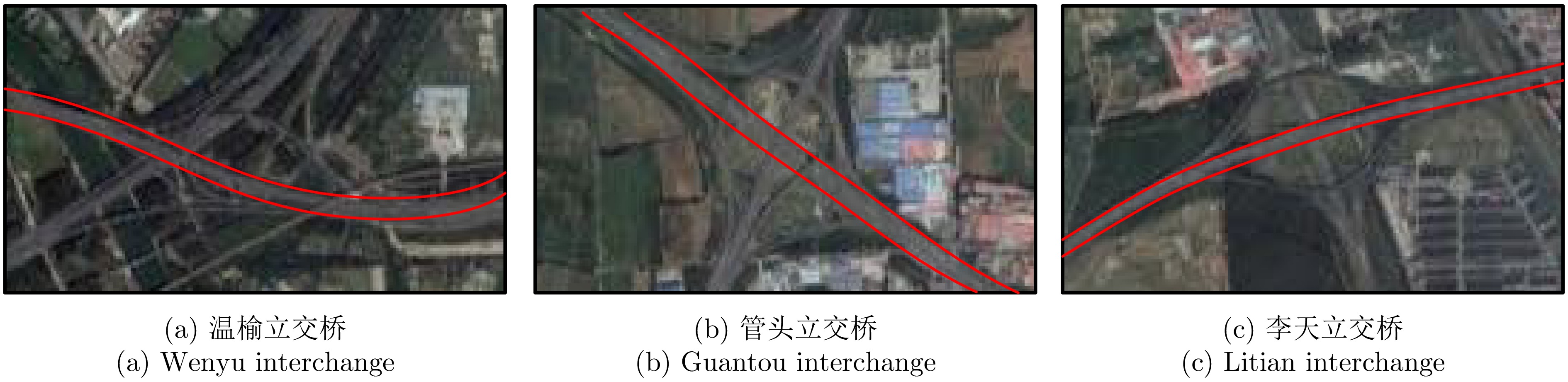
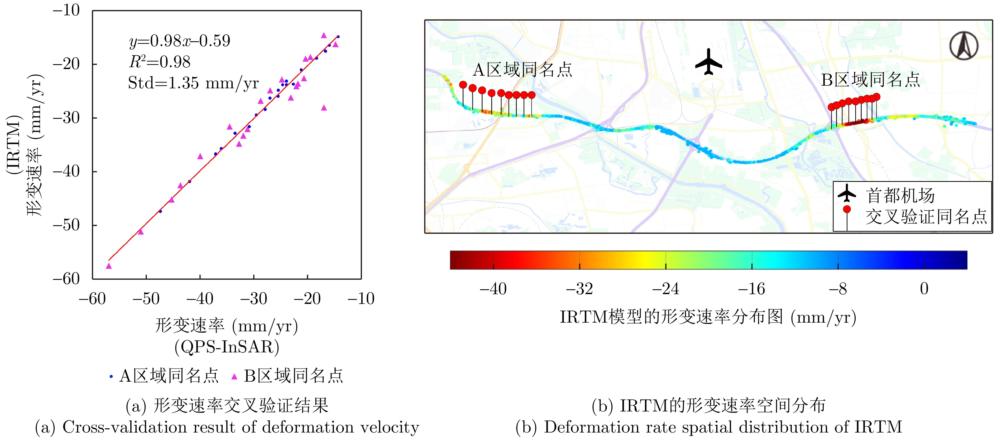
图 9 形变速率与重点形变区域放大图:(a) 形变速率;(b) A区放大图;(c) B区放大图
Figure 9. Magnification of deformation rate and enlarged images of subsiding areas (a) Sptial distribution of velocity; (b) Enlarged image of area A; (c) Enlarged image of area B

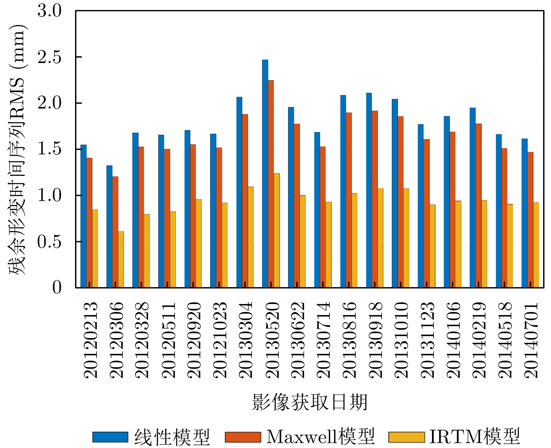
图 10 3种模型的残余形变RMS对比
Figure 10. Comparison of residual deformation RMS for three models

图 12 不同载荷水平下有限元法和IRTM计算变形的比较
Figure 12. Comparison between the deformations estimated by FEA and IRTM under different levels of loadings

图 13 特征点上的分量对比
Figure 13. Comparison of different deformation components at each feature point

图 14 2014年7月25日特征点处光学影像
Figure 14. Feature points with Google image as background on July 25, 2014
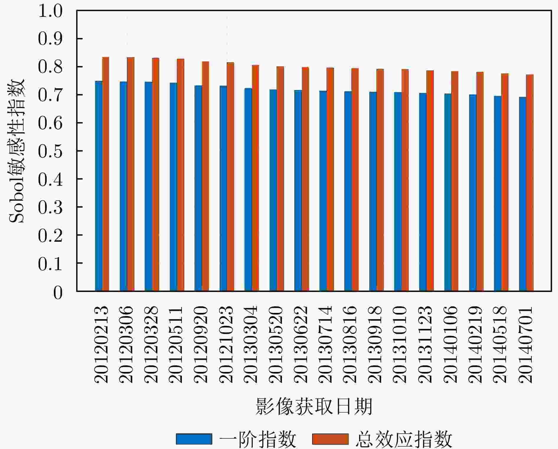
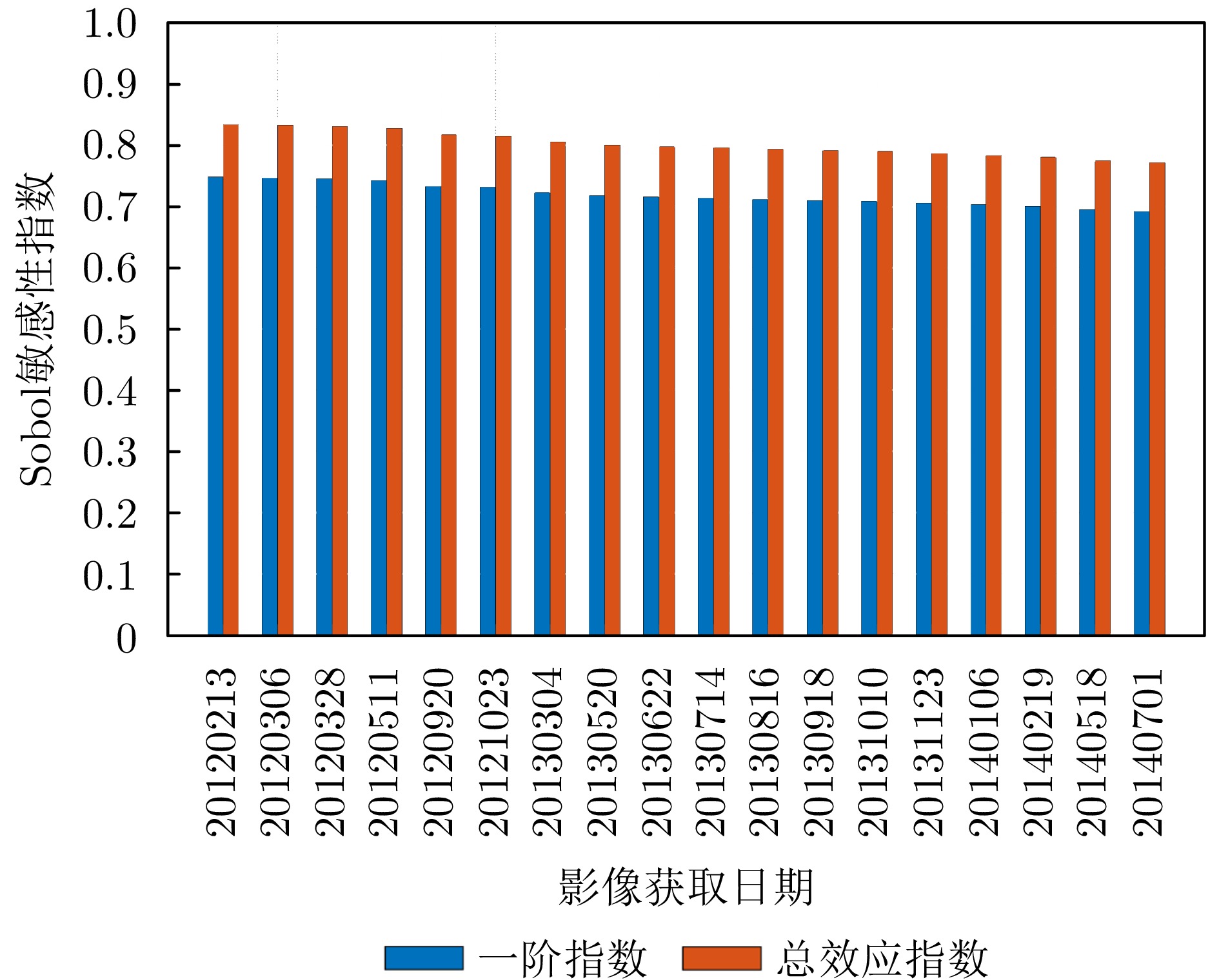
图 16 动应力比参数敏感性分析结果(参考日期:
20120122 )Figure 16. Parameter sensitivity analysis results of dynamic stress ratio at different dates (reference image date:
20120122 )表 1 不同噪声水平下的平均相对误差(%)
Table 1. Mean relative error at different noise levels (%)
噪声等级 z $\eta $ $\beta $ Th - <0.01 0.70 2.70 <0.01 ±0.1 rad <0.01 0.74 3.07 <0.01 ±0.2 rad <0.01 0.81 3.53 <0.01 ±0.3 rad 0.02 0.91 4.17 <0.01 ±0.4 rad 0.03 1.02 4.81 0.01 ±0.5 rad 0.04 1.15 5.77 0.02  下载: 导出CSV
表 2 不同初始条件下的收敛性
Table 2. Convergence under different initial conditions
条件 GA迭代次数 平均迭代次数 最大迭代次数 平均SSR (rad) 最大SSR (rad) 与模拟值相同 50 8.6 12 21.19 25.80 模拟值的2倍 50 10.2 17 25.21 47.32 模拟值的3倍 50 16.7 26 46.03 80.92
下载: 导出CSV
表 3 重要性程度判定标准
Table 3. Criteria for determining significance
参数重要性 Sobal指数取值 非常重要 $ 0.8 < {S}_{\alpha } < {S}_{\alpha }^{{\mathrm{tol}}}\le 1.0 $ 重要 $ 0.5 < {S}_{\alpha } < {S}_{\alpha }^{{\mathrm{tol}}}\le 0.8 $ 不重要 $ 0.3 < {S}_{\alpha } < {S}_{\alpha }^{{\mathrm{tol}}}\le 0.5 $ 不相关 $ 0 < {S}_{\alpha } < {S}_{\alpha }^{{\mathrm{tol}}}\le 0.3 $
下载: 导出CSV
表 4 GA, GARN, GALM算法性能对比
Table 4. Performance comparison of GA, GARN, and GALM algorithms
参数 GA GARN GALM 迭代次数(次) 300 50+250 50+250 耗时(s) 1463 651 286 残余相位STD (rad) 1.57 0.92 0.87
下载: 导出CSV
-
[1] 张成相. 交通荷载作用下软土地基附加沉降计算[J]. 现代交通技术, 2017, 14(5): 16–18. doi: 10.3969/j.issn.1672-9889.2017.05.005.ZHANG Chengxiang. Additional settlement calculation for soft soil foundation under traffic loading[J]. Modern Transportation Technology, 2017, 14(5): 16–18. doi: 10.3969/j.issn.1672-9889.2017.05.005. [2] 王强. 循环荷载作用下广州软土长期累积变形特性试验研究[J]. 安全与环境工程, 2022, 29(4): 205–210, 219. doi: 10.13578/j.cnki.issn.1671-1556.20211040.WANG Qiang. Experimental study on long-term cumulative deformation of Guangzhou soft clay under cyclic loads[J]. Safety and Environmental Engineering, 2022, 29(4): 205–210, 219. doi: 10.13578/j.cnki.issn.1671-1556.20211040. [3] 贺彬. 交通荷载引起的多向耦合应力路径下软粘土变形特性研究[D]. [硕士论文], 哈尔滨工业大学, 2018. doi: 10.7666/d.D01589759.HE Bin. Study on deformation characteristics of soft clay under multi-directional coupled stress path caused by traffic load[D]. [Master dissertation], Harbin Institute of Technology, 2018. doi: 10.7666/d.D01589759. [4] FERRETTI A, PRATI C, and ROCCA F. Permanent scatterers in SAR interferometry[J]. IEEE Transactions on Geoscience and Remote Sensing, 2001, 39(1): 8–20. doi: 10.1109/36.898661. [5] BERARDINO P, FORNARO G, LANARI R, et al. A new algorithm for surface deformation monitoring based on small baseline differential SAR interferograms[J]. IEEE Transactions on Geoscience and Remote Sensing, 2002, 40(11): 2375–2383. doi: 10.1109/TGRS.2002.803792. [6] ZHANG Lei, LU Zhong, DING Xiaoli, et al. Mapping ground surface deformation using temporarily coherent point SAR interferometry: Application to Los Angeles Basin[J]. Remote Sensing of Environment, 2012, 117: 429–439. doi: 10.1016/j.rse.2011.10.020. [7] LV Xiaolei, YAZÍCÍ B, ZEGHAL M, et al. Joint-scatterer processing for time-series InSAR[J]. IEEE Transactions on Geoscience and Remote Sensing, 2014, 52(11): 7205–7221. doi: 10.1109/TGRS.2014.2309346. [8] CHEN Qiang, CHENG Haiqin, YANG Yinghui, et al. Quantification of mass wasting volume associated with the giant landslide Daguangbao induced by the 2008 Wenchuan earthquake from persistent scatterer InSAR[J]. Remote Sensing of Environment, 2014, 152: 125–135. doi: 10.1016/j.rse.2014.06.002. [9] FERRETTI A, FUMAGALLI A, NOVALI F, et al. A new algorithm for processing interferometric data-stacks: SqueeSAR[J]. IEEE Transactions on Geoscience and Remote Sensing, 2011, 49(9): 3460–3470. doi: 10.1109/TGRS.2011.2124465. [10] 云烨, 吕孝雷, 付希凯, 等. 星载InSAR技术在地质灾害监测领域的应用[J]. 雷达学报, 2020, 9(1): 73–85. doi: 10.12000/JR20007.YUN Ye, LÜ Xiaolei, FU Xikai, et al. Application of spaceborne interferometric synthetic aperture radar to geohazard monitoring[J]. Journal of Radars, 2020, 9(1): 73–85. doi: 10.12000/JR20007. [11] 贾洪果, 刘国祥, 于冰. 基于超短基线PSInSAR的道路网沉降监测[J]. 测绘通报, 2012(5): 24–28.JIA Hongguo, LIU Guoxiang, and YU Bing. Monitoring subsidence along road network by ultrashort baseline PSInSAR[J]. Bulletin of Surveying and Mapping, 2012(5): 24–28. [12] YU Bing, LIU Guoxiang, ZHANG Rui, et al. Monitoring subsidence rates along road network by persistent scatterer SAR interferometry with high-resolution TerraSAR-X imagery[J]. Journal of Modern Transportation, 2013, 21(4): 236–246. doi: 10.1007/s40534-013-0030-y. [13] 张庆云, 张景发, 刘国林, 等. 基于高级InSAR时序分析方法的高速公路沉降分析[J]. 科学技术与工程, 2018, 18(20): 20–26. doi: 10.3969/j.issn.1671-1815.2018.20.004.ZHANG Qingyun, ZHANG Jingfa, LIU Guolin, et al. Highway subsidence analysis based on the advanced InSAR time series analysis method[J]. Science Technology and Engineering, 2018, 18(20): 20–26. doi: 10.3969/j.issn.1671-1815.2018.20.004. [14] 赵富萌, 张毅, 孟兴民, 等. 基于小基线集雷达干涉测量的中巴公路盖孜河谷地质灾害早期识别[J]. 水文地质工程地质, 2020, 47(1): 142–152. doi: 10.16030/j.cnki.issn.1000-3665.201902020.ZHAO Fumeng, ZHANG Yi, MENG Xingmin, et al. Early identification of geological hazards in the Gaizi valley near the Karakoran Highway based on SBAS-InSAR technology[J]. Hydrogeology & Engineering Geology, 2020, 47(1): 142–152. doi: 10.16030/j.cnki.issn.1000-3665.201902020. [15] 秦晓琼, 杨梦诗, 王寒梅, 等. 高分辨率PS-InSAR在轨道交通形变特征探测中的应用[J]. 测绘学报, 2016, 45(6): 713–721. doi: 10.11947/j.AGCS.2016.20150440.QIN Xiaoqiong, YANG Mengshi, WANG Hanmei, et al. Application of high-resolution PS-InSAR in deformation characteristics probe of urban rail transit[J]. Acta Geodaetica et Cartographica Sinica, 2016, 45(6): 713–721. doi: 10.11947/j.AGCS.2016.20150440. [16] XING Xuemin, WEN Debao, CHANG H C, et al. Highway deformation monitoring based on an integrated CRInSAR algorithm-simulation and real data validation[J]. International Journal of Pattern Recognition and Artificial Intelligence, 2018, 32(11): 1850036. doi: 10.1142/S0218001418500362. [17] XING Xuemin, CHANG H C, CHEN Lifu, et al. Radar interferometry time series to investigate deformation of soft clay subgrade settlement-a case study of Lungui Highway, China[J]. Remote Sensing, 2019, 11(4): 429. doi: 10.3390/rs11040429. [18] LAZECKÝ M, RAPANT P, PERISSIN D, et al. Deformations of highway over undermined Ostrava-Svinov area monitored by InSAR using limited set of SAR images[J]. Procedia Technology, 2014, 16: 414–421. doi: 10.1016/j.protcy.2014.10.107. [19] TAPETE D, MORELLI S, FANTI R, et al. Localising deformation along the elevation of linear structures: An experiment with space-borne InSAR and RTK GPS on the Roman Aqueducts in Rome, Italy[J]. Applied Geography, 2015, 58: 65–83. doi: 10.1016/j.apgeog.2015.01.009. [20] 张永红, 吴宏安, 孙广通. 时间序列InSAR技术中的形变模型研究[J]. 测绘学报, 2012, 41(6): 864–869, 876.ZHANG Yonghong, HU Hong’an, and SUN Guangtong. Deformation model of time series interferometric SAR techniques[J]. Acta Geodaeticaet Cartographica Sinica, 2012, 41(6): 864–869, 876. [21] 朱茂, 沈体雁, 吕凤华, 等. 青岛胶州湾跨海大桥InSAR形变数据分解和信息提取[J]. 遥感学报, 2020, 24(7): 883–893. doi: 10.11834/jrs.20208085.ZHU Mao, SHEN Tiyan, LYU Fenghua, et al. InSAR deformation data decomposition and information analysis of Jiaozhou bay bridge, Qingdao[J]. Journal of Remote Sensing (Chinese), 2020, 24(7): 883–893. doi: 10.11834/jrs.20208085. [22] FERRETTI A, PRATI C, and ROCCA F. Nonlinear subsidence rate estimation using permanent scatterers in differential SAR interferometry[J]. IEEE Transactions on Geoscience and Remote Sensing, 2000, 38(5): 2202–2212. doi: 10.1109/36.868878. [23] ZHU Yikai, XING Xuemin, CHEN Lifu, et al. Ground subsidence investigation in Fuoshan, China, based on SBAS-InSAR technology with TerraSAR-X images[J]. Applied Sciences, 2019, 9(10): 2038. doi: 10.3390/app9102038. [24] RATEB A and KUO C Y. Quantifying vertical deformation in the Tigris-Euphrates basin due to the groundwater abstraction: Insights from GRACE and Sentinel-1 satellites[J]. Water, 2019, 11(8): 1658. doi: 10.3390/w11081658. [25] ZHAO Rong, LI Zhiwei, FENG Guangcai, et al. Monitoring surface deformation over permafrost with an improved SBAS-InSAR algorithm: With emphasis on climatic factors modeling[J]. Remote Sensing of Environment, 2016, 184: 276–287. doi: 10.1016/j.rse.2016.07.019. [26] YANG Zefa, LI Zhiwei, ZHU Jianjun, et al. Deriving dynamic subsidence of coal mining areas using InSAR and logistic model[J]. Remote Sensing, 2017, 9(2): 125. doi: 10.3390/rs9020125. [27] ZHU Yikai, XING Xuemin, YUAN Zhihui, et al. Surface deformation retrieving over soft clay based on an improved time series InSAR model: A case study of Dongting Lake Area, China[J]. IEEE Access, 2020, 8: 195703–195720. doi: 10.1109/ACCESS.2020.3033381. [28] XING Xuemin, ZHU Yikai, XU Wenbin, et al. Measuring subsidence over soft clay highways using a novel time-series InSAR deformation model with an emphasis on rheological properties and environmental factors (NREM)[J]. IEEE Transactions on Geoscience and Remote Sensing, 2022, 60: 4601319. doi: 10.1109/TGRS.2022.3154430. [29] CROSETTO M, MONSERRAT O, CUEVAS-GONZÁLEZ M, et al. Measuring thermal expansion using X-band persistent scatterer interferometry[J]. ISPRS Journal of Photogrammetry and Remote Sensing, 2015, 100: 84–91. doi: 10.1016/j.isprsjprs.2014.05.006. [30] 黄其欢, 丁幼亮, 王一安, 等. 基于InSAR的南京大胜关大桥纵向位移监测与分析[J]. 东南大学学报(自然科学版), 2017, 47(3): 584–589. doi: 10.3969/j.issn.1001-0505.2017.03.028.HUANG Qihuan, DING Youliang, WANG Yian, et al. InSAR-based longitudinal displacement monitoring and analysis on Nanjing Dashengguan bridge[J]. Journal of Southeast University (Natural Science Edition), 2017, 47(3): 584–589. doi: 10.3969/j.issn.1001-0505.2017.03.028. [31] TANG Xiaochao, STOFFELS S M, and PALOMINO A M. Mechanistic-empirical approach to characterizing permanent deformation of reinforced soft soil subgrade[J]. Geotextiles and Geomembranes, 2016, 44(3): 429–441. doi: 10.1016/j.geotexmem.2015.06.004. [32] NIE Rusong, MEI Huihao, LENG Wuming, et al. Characterization of permanent deformation of fine-grained subgrade soil under intermittent loading[J]. Soil Dynamics and Earthquake Engineering, 2020, 139: 106395. doi: 10.1016/j.soildyn.2020.106395. [33] 刘维正, 石志国, 章定文, 等. 交通荷载作用下结构性软土地基长期沉降计算[J]. 东南大学学报(自然科学版), 2018, 48(4): 726–735. doi: 10.3969/j.issn.1001-0505.2018.04.020.LIU Weizheng, SHI Zhiguo, ZHANG Dingwen, et al. Long-term settlement calculation of structured soft clay foundation under traffic loading[J]. Journal of Southeast University (Natural Science Edition), 2018, 48(4): 726–735. doi: 10.3969/j.issn.1001-0505.2018.04.020. [34] 胡安峰, 张晓冬, 贾玉帅, 等. 饱和软土路基长期沉降计算研究[J]. 岩土工程学报, 2013, 35(S2): 788–792.HU Anfeng, ZHANG Xiaodong, JIA Yushuai, et al. Permanent settlement of subgrade of saturated soft soils[J]. Chinese Journal of Geotechnical Engineering, 2013, 35(S2): 788–792. [35] 魏星, 黄茂松. 交通荷载作用下公路软土地基长期沉降的计算[J]. 岩土力学, 2009, 30(11): 3342–3346. doi: 10.3969/j.issn.1000-7598.2009.11.021.WEI Xing and HUANG Maosong. A simple method to predict traffic-load-induced permanent settlement of road on soft subsoil[J]. Rock and Soil Mechanics, 2009, 30(11): 3342–3346. doi: 10.3969/j.issn.1000-7598.2009.11.021. [36] DE JESÚS RUBIO J. Stability analysis of the modified Levenberg-Marquardt algorithm for the artificial neural network training[J]. IEEE Transactions on Neural Networks and Learning Systems, 2021, 32(8): 3510–3524. doi: 10.1109/TNNLS.2020.3015200. [37] 张鸿燕, 耿征. Levenberg-Marquardt算法的一种新解释[J]. 计算机工程与应用, 2009, 45(19): 5–8. doi: 10.3778/j.issn.1002-8331.2009.19.002.ZHANG Hongyan and GENG Zheng. Novel interpretation for Levenberg-Marquardt algorithm[J]. Computer Engineering and Applications, 2009, 45(19): 5–8. doi: 10.3778/j.issn.1002-8331.2009.19.002. [38] 孙磊, 王军, 谷川, 等. 循环偏应力和循环围压耦合效应对饱和软黏土变形特性的影响[J]. 岩土工程学报, 2015, 37(12): 2198–2204. doi: 10.11779/CJGE201512009.SUN Lei, WANG Jun, GU Chuan, et al. Coupling effects of cyclic deviator stress and cyclic confining pressure on deformation behaviour of saturated clay[J]. Chinese Journal of Geotechnical Engineering, 2015, 37(12): 2198–2204. doi: 10.11779/CJGE201512009. [39] LI Dingqing and SELIG E T. Cumulative plastic deformation for fine-grained subgrade soils[J]. Journal of Geotechnical Engineering, 1996, 122(12): 1006–1013. doi: 10.1061/(ASCE)0733-9410(1996)122:12(1006. [40] QIN Xiaoqiong, ZHANG Lu, DING Xiaoli, et al. Mapping and characterizing thermal dilation of civil infrastructures with multi-temporal X-band synthetic aperture radar interferometry[J]. Remote Sensing, 2018, 10(6): 941. doi: 10.3390/rs10060941. [41] 杨从锐, 钱谦, 王锋, 等. 改进的自适应遗传算法在函数优化中的应用[J]. 计算机应用研究, 2018, 35(4): 1042–1045. doi: 10.3969/j.issn.1001-3695.2018.04.018.YANG Congrui, QIAN Qian, WANG Feng, et al. Application of improved adaptive genetic algorithm in function optimization[J]. Application Research of Computers, 2018, 35(4): 1042–1045. doi: 10.3969/j.issn.1001-3695.2018.04.018. [42] KATOCH S, CHAUHAN S S, and KUMAR V. A review on genetic algorithm: Past, present, and future[J]. Multimedia Tools and Applications, 2021, 80(5): 8091–8126. doi: 10.1007/s11042-020-10139-6. [43] 祝强, 李少康, 徐臻. LM算法求解大残差非线性最小二乘问题研究[J]. 中国测试, 2016, 42(3): 12–16. doi: 10.11857/j.issn.1674-5124.2016.03.003.ZHU Qiang, LI Shaokang, and XU Zhen. Study of solving nonlinear least squares under large residual based on Levenberg-Marquardt algorithm[J]. China Measurement & Test, 2016, 42(3): 12–16. doi: 10.11857/j.issn.1674-5124.2016.03.003. [44] 薛树强, 杨元喜, 党亚民. 测距定位方程非线性平差的封闭牛顿迭代公式[J]. 测绘学报, 2014, 43(8): 771–777. doi: 10.13485/j.cnki.11-2089.2014.0127.XUE Shuqiang, YANG Yuanxi, and DANG Yamin. A closed-form of newton iterative formula for nonlinear adjustment of distance equations[J]. Acta Geodaetica et Cartographica Sinica, 2014, 43(8): 771–777. doi: 10.13485/j.cnki.11-2089.2014.0127. [45] XING Xuemin, ZHU Lingjie, LIU Bin, et al. Measuring land surface deformation over soft clay area based on an FIPR SAR interferometry algorithm-a case study of Beijing capital international airport (China)[J]. Remote Sensing, 2022, 14(17): 4253. doi: 10.3390/rs14174253. [46] 朱凌杰. 软土地基公路时序InSAR形变建模及参数估计[D]. [硕士论文], 长沙理工大学, 2022. doi: 10.26985/d.cnki.gcsjc.2022.001483.ZHU Lingjie. Deformation modeling and parameter estimation based on time series InSAR technique over soft clay highway[D]. [Master dissertation], Changsha University of Science & Technology, 2022. doi: 10.26985/d.cnki.gcsjc.2022.001483. [47] 朱珺, 朱凌杰, 邢学敏, 等. 洞庭湖软土区域时序InSAR形变与环境物理参数联合估计方法[J]. 测绘学报, 2023, 52(12): 2127–2140. doi: 10.11947/j.AGCS.2023.20220287.ZHU Jun, ZHU Lingjie, XING Xuemin, et al. Joint estimation method of time-series InSAR deformation and environmental physical parameters for soft clay area over Dongting lake[J]. Acta Geodaetica et Cartographica Sinica, 2023, 52(12): 2127–2140. doi: 10.11947/j.AGCS.2023.20220287. [48] 白林, 李振洪, 宋莎, 等. 利用时序InSAR技术反演邯郸平原区地表形变与含水层参数[J]. 地球物理学报, 2022, 65(9): 3351–3362. doi: 10.6038/cjg2022P0845.BAI Lin, LI Zhenhong, SONG Sha, et al. Estimation of the land deformation and aquifer parameters in the Handan plain using multi-temporal InSAR technology[J]. Chinese Journal of Geophysics, 2022, 65(9): 3351–3362. doi: 10.6038/cjg2022P0845. [49] 国家测绘地理信息局. CH/T 6006-2018 时间序列InSaR地表形变监测数据处理规范[S]. 北京: 中国标准出版社, 2018.National Administration of Surveying, Mapping and Geoinformation. CH/T 6006-2018 Specification of time series InSAR data processing for ground deformation monitoring[S]. Beijing: Standards Press of China, 2018. [50] GAO Mingli, GONG Huili, LI Xiaojuan, et al. Land subsidence and ground fissures in Beijing capital international airport (BCIA): Evidence from Quasi-PS InSAR analysis[J]. Remote Sensing, 2019, 11(12): 1466. doi: 10.3390/rs11121466. [51] JAWAD A A, ALMUHANNA R R, and SHABAN A M. Three-dimensional finite element analysis for determining subgrade reaction modulus of subgrade soils[C]. Fourth Scientific Conference for Engineering and Postgraduate Research, Baghdad, Iraq, 2020: 012137. doi: 10.1088/1757-899X/745/1/012137. [52] 中华人民共和国交通运输部. JTG D30-2015公路路基设计规范[S]. 北京: 人民交通出版社, 2015.Ministry of Transport of the People’s Republic of China. JTG D30-2015 Specifications for design of highway subgrades[S]. Beijing: China Communications Press, 2015. [53] 李进军, 黄茂松, 王育德. 交通荷载作用下软土地基累积塑性变形分析[J]. 中国公路学报, 2006, 19(1): 1–5. doi: 10.3321/j.issn:1001-7372.2006.01.001.LI Jinjun, HUANG Maosheng, and WANG Yude. Analysis of cumulative plastic deformation of soft clay foundation under traffic loading[J]. China Journal of Highway and Transport, 2006, 19(1): 1–5. doi: 10.3321/j.issn:1001-7372.2006.01.001. [54] 魏连雨, 李巧茹. 标准轴载当量作用次数预估与误差分析[J]. 重庆交通大学学报(自然科学版), 1999, 18(1): 55–60.WEI Lianyu and LI Qiaoru. Estimation of equivalent standard axleload and error analysis[J]. Journal of Chongqing Jiaotong University (Natural Science), 1999, 18(1): 55–60. [55] 张越, 杨红磊, 马建国, 等. 一种地基合成孔径雷达提取DEM的方法[J]. 测绘科学, 2018, 43(11): 125–130. doi: 10.16251/j.cnki.1009-2307.2018.11.020.ZHANG Yue, YANG Honglei, MA Jianguo, et al. A method for extracting DEM from ground SAR[J]. Science of Surveying and Mapping, 2018, 43(11): 125–130. doi: 10.16251/j.cnki.1009-2307.2018.11.020. [56] 邓永和. InSAR测高精度的精密公式[J]. 大地测量与地球动力学, 2010, 30(1): 92–94. doi: 10.3969/j.issn.1671-5942.2010.01.020.DENG Yonghe. Precision formulae of height measurement accuracy with InSAR[J]. Journal of Geodesy and Geodynamics, 2010, 30(1): 92–94. doi: 10.3969/j.issn.1671-5942.2010.01.020. [57] GRAHAM J, CROOKS J H A, and BELL A L. Time effects on the stress-strain behaviour of natural soft clays[J]. Géotechnique, 1983, 33(3): 327–340. doi: 10.1680/geot.1983.33.3.327. [58] CANNAVÓ F. Sensitivity analysis for volcanic source modeling quality assessment and model selection[J]. Computers & Geosciences, 2012, 44: 52–59. doi: 10.1016/j.cageo.2012.03.008. -


计量
- 文章访问数:
- HTML全文浏览量:
- PDF下载量:
- 被引次数: 0

