
 作者中心
作者中心 专家审稿
专家审稿 责编办公
责编办公 编辑办公
编辑办公
Research Progress on SAR Inversion of Crop and Soil Parameters Based on Microwave Scattering Theory
-
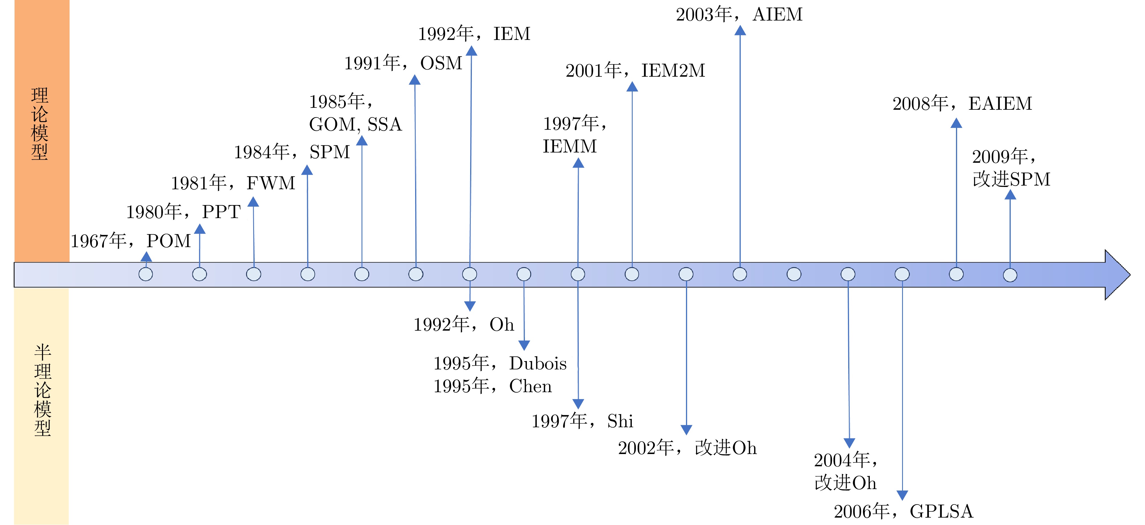
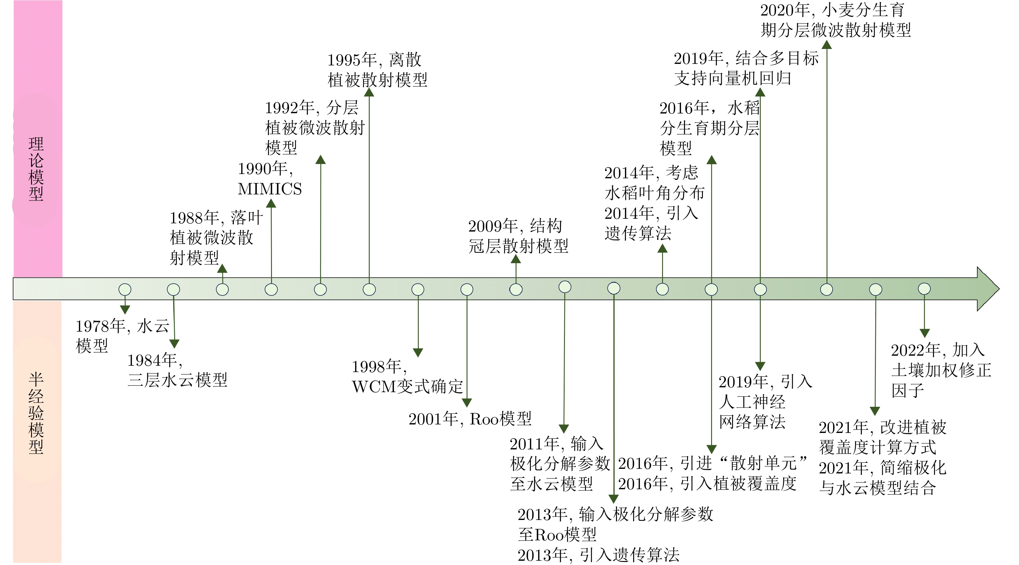
摘要: 作物和土壤参数是表征作物生长状态、监测作物长势的重要基础。雷达遥感具有全天时、全天候、不受气象条件影响的观测能力,微波的穿透能力也对作物覆盖下土壤参数变化具有较强敏感性,在作物土壤参数反演中极具潜力。该文围绕微波散射理论下的作物土壤参数反演模型展开研究和综述。首先回顾了微波散射模型从理论模型发展为半经验模型的历程,明晰模型理论演变趋势与方法改进方向。然后,详细介绍了基于微波散射机理的作物参数、土壤参数以及作物土壤参数耦合的反演方法。最后,阐明模型不足,结合当下技术发展特点明确了未来发展的重点方向,以期为后续研究提供新思路。Abstract: Crop and soil parameters serve as fundamental indicators for characterizing crop growth status and monitoring vegetation dynamics. Radar remote sensing presents unique advantages, such as all-weather and day-and-night observation capabilities, as well as insensitivity to meteorological conditions. Furthermore, the penetration ability of microwaves enhances the sensitivity to soil parameter variations beneath crop canopies, demonstrating significant potential for retrieving crop and soil parameters. This article presents a comprehensive review and analysis of inversion models used for crop and soil parameters based on the microwave scattering theory. First, it discusses the evolution of microwave scattering models from theoretical frameworks to semiempirical approaches, demonstrating key trends in theoretical advancements and methodological refinements. Subsequently, it systematically examines inversion methods for crop parameters, soil parameters, and crop-soil interactions, revealing their underlying microwave scattering mechanisms. Finally, the article discusses current model limitations and proposes future research directions aligned with emerging technological developments to provide novel insights for subsequent investigations.
-
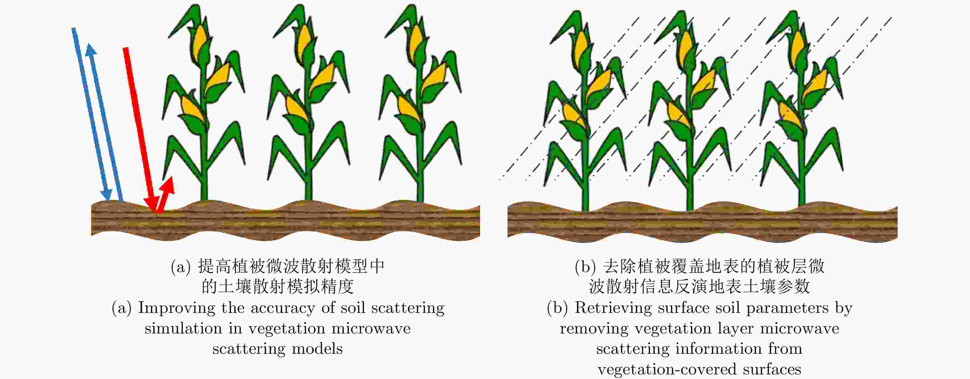
图 3 作物土壤参数反演模型示意图
Figure 3. Schematic diagram of crop and soil parameter inversion model
表 1 WCM参数设置
Table 1. WCM parameter setting
作物 $ {V}_{1} $ $ {V}_{2} $ 参考文献 黄秋葵 LAI BM [81] 芸豆 LAI LWAI [82] 水稻 LAI LAI [80] 水稻 BM BM [85] 玉米 1 LAI [83] 小麦 LAI IF [86,87] 大豆、玉米 $ {\mathrm{L}\mathrm{A}\mathrm{I}}^{{E}_{1}} $ $ {\mathrm{L}\mathrm{A}\mathrm{I}}^{{E}_{2}} $ [84,88] 小麦、玉米等 $ {\mathrm{L}\mathrm{A}\mathrm{I}}^{{E}_{1}} $ $ {\mathrm{B}\mathrm{M}}^{{E}_{2}} $ [89,90] 注:叶面积指数(LAI),生物量(BM),叶片含水量(Leaf Water Area Index, LWAI),作物冠层垂直不均匀性描述符(Interaction Fctor, IF),$ {E}_{1} $和$ {E}_{2} $为待确定参数。  下载: 导出CSV
-
[1] 吴素霞, 毛任钊, 李红军, 等. 中国农作物长势遥感监测研究综述[J]. 中国农学通报, 2005, 21(3): 319–322, 345. doi: 10.3969/j.issn.1000-6850.2005.03.091.WU Suxia, MAO Renzhao, LI Hongjun, et al. Review of crop condition monitoring using remote sensing in China[J]. Chinese Agricultural Science Bulletin, 2005, 21(3): 319–322, 345. doi: 10.3969/j.issn.1000-6850.2005.03.091. [2] 赵春江. 农业遥感研究与应用进展[J]. 农业机械学报, 2014, 45(12): 277–293. doi: 10.6041/j.issn.1000-1298.2014.12.041.ZHAO Chunjiang. Advances of research and application in remote sensing for agriculture[J]. Transactions of the Chinese Society for Agricultural Machinery, 2014, 45(12): 277–293. doi: 10.6041/j.issn.1000-1298.2014.12.041. [3] 程志强, 蒙继华. 作物单产估算模型研究进展与展望[J]. 中国生态农业学报, 2015, 23(4): 402–415. doi: 10.13930/j.cnki.cjea.141218.CHENG Zhiqiang and MENG Jihua. Research advances and perspectives on crop yield estimation models[J]. Chinese Journal of Eco-Agriculture, 2015, 23(4): 402–415. doi: 10.13930/j.cnki.cjea.141218. [4] 王福民, 李嘉乐, 段四波, 等. 农业遥感技术发展新需求与新挑战[J]. 中国农业信息, 2023, 35(6): 9–21. doi: 10.12105/j.issn.1672-0423.20230602.WANG Fumin, LI Jiale, DUAN Sibo, et al. New demands and challenges for the development of agricultural remote sensing[J]. China Agricultural Information, 2023, 35(6): 9–21. doi: 10.12105/j.issn.1672-0423.20230602. [5] 赵龙才, 李粉玲, 常庆瑞. 农作物遥感识别与单产估算研究综述[J]. 农业机械学报, 2023, 54(2): 1–19. doi: 10.6041/j.issn.1000-1298.2023.02.001.ZHAO Longcai, LI Fenling, and CHANG Qingrui. Review on crop type identification and yield forecasting using remote sensing[J]. Transactions of the Chinese Society for Agricultural Machinery, 2023, 54(2): 1–19. doi: 10.6041/j.issn.1000-1298.2023.02.001. [6] 陈仲新, 任建强, 唐华俊, 等. 农业遥感研究应用进展与展望[J]. 遥感学报, 2016, 20(5): 748–767. doi: 10.11834/jrs.20166214.CHEN Zhongxin, REN Jianqiang, TANG Huajun, et al. Progress and perspectives on agricultural remote sensing research and applications in China[J]. Journal of Remote Sensing, 2016, 20(5): 748–767. doi: 10.11834/jrs.20166214. [7] 尹高飞, 车伟, 于慧男. 植被生物物理参数的光学遥感反演方法综述[J]. 测绘, 2023, 46(5): 195–198. doi: 10.3969/j.issn.1674-5019.2023.05.001.YIN Gaofei, CHE Wei, and YU Huinan. Review of optical remote sensing retrieval of vegetation biophysical parameters[J]. Surveying and Mapping, 2023, 46(5): 195–198. doi: 10.3969/j.issn.1674-5019.2023.05.001. [8] 何泽, 李世华. 水稻雷达遥感监测研究进展[J]. 遥感学报, 2023, 27(10): 2363–2382. doi: 10.11834/jrs.20221701.HE Ze and LI Shihua. Research progress on radar remote sensing for rice growth monitoring[J]. National Remote Sensing Bulletin, 2023, 27(10): 2363–2382. doi: 10.11834/jrs.20221701. [9] 洪玉娇, 张硕, 李俐. 基于合成孔径雷达数据的农作物长势监测研究进展[J]. 智慧农业(中英文), 2024, 6(1): 46–62. doi: 10.12133/j.smartag.SA202308019.HONG Yujiao, ZHANG Shuo, and LI Li. Research progresses of crop growth monitoring based on synthetic aperture radar data[J]. Smart Agriculture, 2024, 6(1): 46–62. doi: 10.12133/j.smartag.SA202308019. [10] 李平湘, 赵伶俐, 任烨仙. 合成孔径雷达在农业监测中的应用和展望[J]. 地理空间信息, 2017, 15(3): 1–4. doi: 10.3969/j.issn.1672-4623.2017.03.001.LI Pingxiang, ZHAO Lingli, and REN Yexian. Outlook and application of the synthetic aperture radar in agriculture monitoring[J]. Geospatial Information, 2017, 15(3): 1–4. doi: 10.3969/j.issn.1672-4623.2017.03.001. [11] 张王菲, 陈尔学, 李增元, 等. 雷达遥感农业应用综述[J]. 雷达学报, 2020, 9(3): 444–461. doi: 10.12000/JR20051.ZHANG Wangfei, CHEN Erxue, LI Zengyuan, et al. Review of applications of radar remote sensing in agriculture[J]. Journal of Radars, 2020, 9(3): 444–461. doi: 10.12000/JR20051. [12] 张亚红, 吴娇娇, 胥喆, 等. 合成孔径雷达在农作物长势监测中的应用[J]. 安徽农业科学, 2016, 44(27): 220–222, 244. doi: 10.13989/j.cnki.0517-6611.2016.27.074.ZHANG Yahong, WU Jiaojiao, XU Zhe, et al. Application of synthetic aperture radar in crop growth monitoring[J]. Journal of Anhui Agricultural Sciences, 2016, 44(27): 220–222, 244. doi: 10.13989/j.cnki.0517-6611.2016.27.074. [13] 周兴霞, 王颖洁, 杨攀. 基于光学与雷达遥感影像协作的多云雾区域农作物信息提取研究[J]. 遥感技术与应用, 2024, 39(2): 362–372. doi: 10.11873/j.issn.1004-0323.2024.2.0362.ZHOU Xingxia, WANG Yingjie, and YANG Pan. Extraction of crop information in cloudy areas based on optical and radar remote sensing images[J]. Remote Sensing Technology and Application, 2024, 39(2): 362–372. doi: 10.11873/j.issn.1004-0323.2024.2.0362. [14] 李俐, 王荻, 潘彩霞, 等. 土壤水分反演中的主动微波散射模型[J]. 国土资源遥感, 2016, 28(4): 1–9. doi: 10.6046/gtzyyg.2016.04.01.LI Li, WANG Di, PAN Caixai, et al. Active microwave scattering models used in soil moisture retrieval[J]. Remote Sensing for Land & Resources, 2016, 28(4): 1–9. doi: 10.6046/gtzyyg.2016.04.01. [15] 李俐, 王荻, 王鹏新, 等. 合成孔径雷达土壤水分反演研究进展[J]. 资源科学, 2015, 37(10): 1929–1940.LI Li, WANG Di, WANG Pengxin, et al. Progress on monitoring soil moisture using SAR data[J]. Resources Science, 2015, 37(10): 1929–1940. [16] 覃湘栋, 庞治国, 江威, 等. 土壤水分微波反演方法进展和发展趋势[J]. 地球信息科学学报, 2021, 23(10): 1728–1742. doi: 10.12082/dqxxkx.2021.210104.QIN Xiangdong, PANG Zhiguo, JIANG Wei, et al. Progress and development trend of soil moisture microwave remote sensing retrieval method[J]. Journal of Geo-Information Science, 2021, 23(10): 1728–1742. doi: 10.12082/dqxxkx.2021.210104. [17] 徐嘉昕, 李璇, 朱永超, 等. 地表土壤水分的卫星遥感反演方法研究进展[J]. 气象科技进展, 2019, 9(2): 17–23. doi: 10.3969/j.issn.2095-1973.2019.02.003.XU Jiaxin, LI Xuan, ZHU Yongchao, et al. Progress of the methods of remote sensing monitoring the soil moisture[J]. Advances in Meteorological Science and Technology, 2019, 9(2): 17–23. doi: 10.3969/j.issn.2095-1973.2019.02.003. [18] 张滢, 丁建丽, 周鹏. 干旱区土壤水分微波遥感反演算法综述[J]. 干旱区地理, 2011, 34(4): 671–678. doi: 10.13826/j.cnki.cn65-1103/x.2011.04.015.ZHANG Ying, DING Jianli, and ZHOU Peng. Model algorithm of soil moisture retrieval base on microwave remote sensing in arid regions[J]. Arid Land Geography, 2011, 34(4): 671–678. doi: 10.13826/j.cnki.cn65-1103/x.2011.04.015. [19] 赵少华, 秦其明, 沈心一, 等. 微波遥感技术监测土壤湿度的研究[J]. 微波学报, 2010, 26(2): 90–96. doi: 10.14183/j.cnki.1005-6122.2010.02.023.ZHAO Shaohua, QIN Qiming, SHEN Xinyi, et al. Review of microwave remote sensing on soil moisture monitoring[J]. Journal of Microwaves, 2010, 26(2): 90–96. doi: 10.14183/j.cnki.1005-6122.2010.02.023. [20] 钟雪, 杨明龙, 唐秀娟, 等. 土壤水分卫星遥感反演方法研究进展[J]. 干旱气象, 2024, 42(4): 637–648. doi: 10.11755/j.issn.1006-7639(2024)-04-0637.ZHONG Xue, YANG Minglong, TANG Xiujuan, et al. Progress of satellite remote sensing inversion method for soil moisture[J]. Journal of Arid Meteorology, 2024, 42(4): 637–648. doi: 10.11755/j.issn.1006-7639(2024)-04-0637. [21] 朱逸青, 吴尚蓉, 王迪. 土壤水分雷达遥感反演研究[J]. 中国农业信息, 2024, 36(3): 45–62. doi: 10.12105/j.issn.1672-0423.20240304.ZHU Yiqing, WU Shangrong, and WANG Di. Soil moisture retrieval by radar remote sensing[J]. China Agricultural Information, 2024, 36(3): 45–62. doi: 10.12105/j.issn.1672-0423.20240304. [22] 许涛, 廖静娟, 沈国状, 等. 植被微波散射模型研究综述[J]. 遥感信息, 2015, 30(5): 3–13. doi: 10.3969/j.issn.1000-3177.2015.05.001.XU Tao, LIAO Jingjuan, SHEN Guozhuang, et al. Progresses on microwave scattering model of vegetation[J]. Remote Sensing Information, 2015, 30(5): 3–13. doi: 10.3969/j.issn.1000-3177.2015.05.001. [23] BOUMAN B A M. Crop parameter estimation from ground-based X-band (3-cm wave) radar backscattering data[J]. Remote Sensing of Environment, 1991, 37(3): 193–205. doi: 10.1016/0034-4257(91)90081-G. [24] 张晓倩, 郭琳, 马尚杰, 等. 利用时序合成孔径雷达数据监测水稻叶面积指数[J]. 农业工程学报, 2014, 30(13): 185–193. doi: 10.3969/j.issn.1002-6819.2014.13.023.ZHANG Xiaoqian, GUO Lin, MA Shangjie, et al. Monitoring rice leaf area index using time-series SAR data[J]. Transactions of the Chinese Society of Agricultural Engineering, 2014, 30(13): 185–193. doi: 10.3969/j.issn.1002-6819.2014.13.023. [25] KARTHIKEYAN L, PAN Ming, WANDERS N, et al. Four decades of microwave satellite soil moisture observations: Part 1. A review of retrieval algorithms[J]. Advances in Water Resources, 2017, 109: 106–120. doi: 10.1016/j.advwatres.2017.09.006. [26] 张琳琳, 雷志斌, 王莉萍, 等. 基于高分三号卫星合成孔径雷达数据的农田土壤水分反演[J]. 浙江大学学报: 农业与生命科学版, 2024, 50(2): 209–220. doi: 10.3785/j.issn.1008-9209.2023.12.183.ZHANG Linlin, LEI Zhibin, WANG Liping, et al. Retrieval of soil moisture based on Gaofen-3 (GF-3) satellite synthetic aperture radar data over agricultural fields[J]. Journal of Zhejiang University: Agriculture & Life Sciences, 2024, 50(2): 209–220. doi: 10.3785/j.issn.1008-9209.2023.12.183. [27] ATTEMA E P W and ULABY F T. Vegetation modeled as a water cloud[J]. Radio Science, 1978, 13(2): 357–364. doi: 10.1029/RS013i002p00357. [28] ULABY F T, ALLEN C T, EGER III G, et al. Relating the microwave backscattering coefficient to leaf area index[J]. Remote Sensing of Environment, 1984, 14(1/3): 113–133. doi: 10.1016/0034-4257(84)90010-5. [29] 陶亮亮, 李京, 蒋金豹, 等. 利用RADARSAT-2雷达数据与改进的水云模型反演冬小麦叶面积指数[J]. 麦类作物学报, 2016, 36(2): 236–242. doi: 10.7606/j.issn.1009-1041.2016.02.15.TAO Liangliang, LI Jing, JIANG Jinbao, et al. Leaf area index inversion of winter wheat using RADARSAT-2 data and modified water-cloud model[J]. Journal of Triticeae Crops, 2016, 36(2): 236–242. doi: 10.7606/j.issn.1009-1041.2016.02.15. [30] KARAM M A and FUNG A K. Electromagnetic scattering from a layer of finite length, randomly oriented, dielectric, circular cylinders over a rough interface with application to vegetation[J]. International Journal of Remote Sensing, 1988, 9(6): 1109–1134. doi: 10.1080/01431168808954918. [31] ULABY F T, SARABANDI K, MCDONALD K, et al. Michigan microwave canopy scattering model[J]. International Journal of Remote Sensing, 1990, 11(7): 1223–1253. doi: 10.1080/01431169008955090. [32] KARAM M A, FUNG A K, LANG R H, et al. A microwave scattering model for layered vegetation[J]. IEEE Transactions on Geoscience and Remote Sensing, 1992, 30(4): 767–784. doi: 10.1109/36.158872. [33] KARAM M A, AMAR F, FUNG A K, et al. A microwave polarimetric scattering model for forest canopies based on vector radiative transfer theory[J]. Remote Sensing of Environment, 1995, 53(1): 16–30. doi: 10.1016/0034-4257(95)00048-6. [34] DE ROO R D, DU Yang, ULABY F T, et al. A semi-empirical backscattering model at L-band and C-band for a soybean canopy with soil moisture inversion[J]. IEEE Transactions on Geoscience and Remote Sensing, 2001, 39(4): 864–872. doi: 10.1109/36.917912. [35] WANG Cuizhen, WU Jiaping, ZHANG Yuan, et al. Characterizing L-band scattering of paddy rice in southeast China with radiative transfer model and multitemporal ALOS/PALSAR imagery[J]. IEEE Transactions on Geoscience and Remote Sensing, 2009, 47(4): 988–998. doi: 10.1109/TGRS.2008.2008309. [36] LIU Yu, CHEN Kunshan, XU Peng, et al. Modeling and characteristics of microwave backscattering from rice canopy over growth stages[J]. IEEE Transactions on Geoscience and Remote Sensing, 2016, 54(11): 6757–6770. doi: 10.1109/TGRS.2016.2590439. [37] WU Shangrong, YANG Peng, REN Jianqiang, et al. Winter wheat LAI inversion considering morphological characteristics at different growth stages coupled with microwave scattering model and canopy simulation model[J]. Remote Sensing of Environment, 2020, 240: 111681. doi: 10.1016/j.rse.2020.111681. [38] VALENZUELA G. Depolarization of EM waves by slightly rough surfaces[J]. IEEE Transactions on Antennas and Propagation, 1967, 15(4): 552–557. doi: 10.1109/TAP.1967.1138962. [39] SHEN J and MARADUDIN A A. Multiple scattering of waves from random rough surfaces[J]. Physical Review B, 1980, 22(9): 4234–4240. doi: 10.1103/PhysRevB.22.4234. [40] BAHAR E. Full-wave solutions for the depolarization of the scattered radiation fields by rough surfaces of arbitrary slope[J]. IEEE Transactions on Antennas and Propagation, 1981, 29(3): 443–454. doi: 10.1109/TAP.1981.1142604. [41] MICHAELI A. Equivalent edge currents for arbitrary aspects of observation[J]. IEEE Transactions on Antennas and Propagation, 1984, 32(3): 252–258. doi: 10.1109/TAP.1984.1143303. [42] LI Xiaowen and STRAHLER A H. Geometric-optical modeling of a conifer forest canopy[J]. IEEE Transactions on Geoscience and Remote Sensing, 1985, GE-23(5): 705–721. doi: 10.1109/TGRS.1985.289389. [43] MILDER D M. An improved formalism for wave scattering from rough surfaces[J]. The Journal of the Acoustical Society of America, 1991, 89(2): 529–541. doi: 10.1121/1.400377. [44] FUNG A K, LI Zongqian, and CHEN Kunshan. Backscattering from a randomly rough dielectric surface[J]. IEEE Transactions on Geoscience and Remote Sensing, 1992, 30(2): 356–369. doi: 10.1109/36.134085. [45] HSIEH C Y, FUNG A K, NESTI G, et al. A further study of the IEM surface scattering model[J]. IEEE Transactions on Geoscience and Remote Sensing, 1997, 35(4): 901–909. doi: 10.1109/36.602532. [46] ÁLVAREZ-PÉREZ J L. An extension of the IEM/IEMM surface scattering model[J]. Waves in Random Media, 2001, 11(3): 307–329. doi: 10.1088/0959-7174/11/3/308. [47] CHEN Kunshan, WU T D, TSANG L, et al. Emission of rough surfaces calculated by the integral equation method with comparison to three-dimensional moment method simulations[J]. IEEE Transactions on Geoscience and Remote Sensing, 2003, 41(1): 90–101. doi: 10.1109/TGRS.2002.807587. [48] WU T D and CHEN Kunshan. A reappraisal of the validity of the IEM model for backscattering from rough surfaces[J]. IEEE Transactions on Geoscience and Remote Sensing, 2004, 42(4): 743–753. doi: 10.1109/TGRS.2003.815405. [49] DU Yang. A new bistatic model for electromagnetic scattering from randomly rough surfaces[J]. Waves in Random and Complex Media, 2008, 18(1): 109–128. doi: 10.1080/17455030701459902. [50] OH Y, SARABANDI K, and ULABY F T. An empirical model and an inversion technique for radar scattering from bare soil surfaces[J]. IEEE Transactions on Geoscience and Remote Sensing, 1992, 30(2): 370–381. doi: 10.1109/36.134086. [51] DUBOIS P C, VAN ZYL J, and ENGMAN T. Measuring soil moisture with imaging radars[J]. IEEE Transactions on Geoscience and Remote Sensing, 1995, 33(4): 915–926. doi: 10.1109/36.406677. [52] CHEN Kunshan, YEN S K, and HUANG Wenpin. A simple model for retrieving bare soil moisture from radar-scattering coefficients[J]. Remote Sensing of Environment, 1995, 54(2): 121–126. doi: 10.1016/0034-4257(95)00129-O. [53] SHI Jiancheng, WANG J, HSU A Y, et al. Estimation of bare surface soil moisture and surface roughness parameter using L-band SAR image data[J]. IEEE Transactions on Geoscience and Remote Sensing, 1997, 35(5): 1254–1266. doi: 10.1109/36.628792. [54] OH Y, SARABANDI K, and ULABY F T. Semi-empirical model of the ensemble-averaged differential Mueller matrix for microwave backscattering from bare soil surfaces[J]. IEEE Transactions on Geoscience and Remote Sensing, 2002, 40(6): 1348–1355. doi: 10.1109/TGRS.2002.800232. [55] OH Y. Quantitative retrieval of soil moisture content and surface roughness from multipolarized radar observations of bare soil surfaces[J]. IEEE Transactions on Geoscience and Remote Sensing, 2004, 42(3): 596–601. doi: 10.1109/TGRS.2003.821065. [56] LOEW A and MAUSER W. A semiempirical surface backscattering model for bare soil surfaces based on a generalized power law spectrum approach[J]. IEEE Transactions on Geoscience and Remote Sensing, 2006, 44(4): 1022–1035. doi: 10.1109/TGRS.2005.862501. [57] 闫文佳. 基于微波散射模型与支持向量机算法的麦田参数反演研究[D]. [硕士论文], 华东师范大学, 2019.YAN Wenjia. Synergy of microwave scattering simulation and SVM algorithm for retrieval of biophysical parameters in wheat fields[D]. [Master dissertation], East China Normal University, 2019. [58] KATZIN M. The scattering of electromagnetic waves from rough surfaces[J]. Proceedings of the IEEE, 1964, 52(11): 1389–1390. doi: 10.1109/PROC.1964.3413. [59] RICE S O. Reflection of electromagnetic waves from slightly rough surfaces[J]. Communications on Pure and Applied Mathematics, 1951, 4(2/3): 351–378. doi: 10.1002/cpa.3160040206. [60] 何宜军. 海浪微波散射理论模式[J]. 海洋与湖沼, 2000, 31(2): 178–185. doi: 10.3321/j.issn:0029-814X.2000.02.010.HE Yijun. An ocean wave microwave backscattering model[J]. Oceanologia et Limnologia Sinica, 2000, 31(2): 178–185. doi: 10.3321/j.issn:0029-814X.2000.02.010. [61] PLANT W J. A stochastic, multiscale model of microwave backscatter from the ocean[J]. Journal of Geophysical Research: Oceans, 2002, 107(C9): 3120. doi: 10.1029/2001JC000909. [62] HUANG Shaowu, TSANG L, NJOKU E G, et al. Backscattering coefficients, coherent reflectivities, and emissivities of randomly rough soil surfaces at L-Band for SMAP applications based on numerical solutions of maxwell equations in three-dimensional simulations[J]. IEEE Transactions on Geoscience and Remote Sensing, 2010, 48(6): 2557–2568. doi: 10.1109/TGRS.2010.2040748. [63] WOLF E. New theory of radiative energy transfer in free electromagnetic fields[J]. Physical Review D, 1976, 13(4): 869–886. doi: 10.1103/PhysRevD.13.869. [64] KARAM M A and FUNG A K. Leaf-shape effects in electromagnetic wave scattering from vegetation[J]. IEEE Transactions on Geoscience and Remote Sensing, 1989, 27(6): 687–697. doi: 10.1109/TGRS.1989.1398241. [65] ZHANG Yuan, LIU Xiaohui, SU Shiliang, et al. Retrieving canopy height and density of paddy rice from Radarsat-2 images with a canopy scattering model[J]. International Journal of Applied Earth Observation and Geoinformation, 2014, 28: 170–180. doi: 10.1016/j.jag.2013.12.005. [66] 齐震. 水稻的微波散射模型[J]. 中国科学院研究生院学报, 1999, 16(2): 177–184.QI Zhen. The microwave backscattering model of rice[J]. Journal of University of Chinese Academy of Sciences, 1999, 16(2): 177–184. [67] 王芳, 陶建军, 姜良美. 农作物覆盖地表微波遥感模型研究进展[J]. 遥感技术与应用, 2011, 26(2): 255–262. doi: 10.11873/j.issn.1004-0323.2011.2.255.WANG Fang, TAO Jianjun, and JIANG Liangmei. Review of microwave remote sensing models of agricultural field[J]. Remote Sensing Technology and Application, 2011, 26(2): 255–262. doi: 10.11873/j.issn.1004-0323.2011.2.255. [68] 曹培, 王道伟, 林明壮, 等. 冬小麦覆被农田地表多层非均质混合电磁散射模型研究[J]. 农业机械学报, 2023, 54(11): 169–179, 285. doi: 10.6041/j.issn.1000-1298.2023.11.016.CAO Pei, WANG Daowei, LIN Mingzhuang, et al. Electromagnetic scattering model of farmland surface covered with winter wheat[J]. Transactions of the Chinese Society for Agricultural Machinery, 2023, 54(11): 169–179, 285. doi: 10.6041/j.issn.1000-1298.2023.11.016. [69] 王芳, 张立新, 李丽英. 基于微波植被离散散射模型的小麦双站散射和辐射特征研究[J]. 遥感信息, 2008, 30(3): 7–14. doi: 10.3969/j.issn.1000-3177.2008.03.002.WANG Fang, ZHANG Lixin, and LI Liying. Discrete scatter model for microwave bistatic scattering and emission from wheat field[J]. Remote Sensing Information, 2008, 30(3): 7–14. doi: 10.3969/j.issn.1000-3177.2008.03.002. [70] WIGNERON J P, FERRAZZOLI P, OLIOSO A, et al. A simple approach to monitor crop biomass from C-band radar data[J]. Remote Sensing of Environment, 1999, 69(2): 179–188. doi: 10.1016/s0034-4257(99)00011-5. [71] TOURE A, THOMSON K P B, EDWARDS G, et al. Adaptation of the MIMICS backscattering model to the agricultural context-wheat and canola at L and C bands[J]. IEEE Transactions on Geoscience and Remote Sensing, 1994, 32(1): 47–61. doi: 10.1109/36.285188. [72] 戈建军, 王超. 冬小麦微波散射特性研究[J]. 遥感信息, 2002, 24(3): 7–10, 47. doi: 10.3969/j.issn.1000-3177.2002.03.002.GE Jianjun and WANG Chao. Winter wheat microwave scattering characteristics research[J]. Remote Sensing Information, 2002, 24(3): 7–10, 47. doi: 10.3969/j.issn.1000-3177.2002.03.002. [73] 蔡爱民, 邵芸, 李坤, 等. 冬小麦不同生长期雷达后向散射特征分析与应用[J]. 农业工程学报, 2010, 26(7): 205–212. doi: 10.3969/j.issn.1002-6819.2010.07.036.CAI Aimin, SHAO Yun, LI Kun, et al. Analysis of backscattering characters of winter wheat in different phenophase and its applications[J]. Transactions of the Chinese Society of Agricultural Engineering, 2010, 26(7): 205–212. doi: 10.3969/j.issn.1002-6819.2010.07.036. [74] 王芳. 玉米地微波相干和非相干散射模型比较分析[J]. 安徽农业科学, 2012, 40(10): 6309–6312. doi: 10.13989/j.cnki.0517-6611.2012.10.177.WANG Fang. Comparisons between microwave coherent and incoherent scattering models in corn field[J]. Journal of Anhui Agricultural Sciences, 2012, 40(10): 6309–6312. doi: 10.13989/j.cnki.0517-6611.2012.10.177. [75] 贾明权. 水稻微波散射特性研究及参数反演[D]. [博士论文], 电子科技大学, 2013.JIA Mingquan. Research on rice microwave scattering mechanism and parameter inversion[D]. [Ph.D. dissertation], University of Electronic Science and Technology of China, 2013. [76] MAITY S, PATNAIK C, CHAKRABORTY M, et al. Analysis of temporal backscattering of cotton crops using a semiempirical model[J]. IEEE Transactions on Geoscience and Remote Sensing, 2004, 42(3): 577–587. doi: 10.1109/TGRS.2003.821888. [77] BRACAGLIA M, FERRAZZOLI P, and GUERRIERO L. A fully polarimetric multiple scattering model for crops[J]. Remote Sensing of Environment, 1995, 54(3): 170–179. doi: 10.1016/0034-4257(95)00151-4. [78] PRÉVOT L, CHAMPION I, and GUYOT G. Estimating surface soil moisture and leaf area index of a wheat canopy using a dual-frequency (C and X bands) scatterometer[J]. Remote Sensing of Environment, 1993, 46(3): 331–339. doi: 10.1016/0034-4257(93)90053-Z. [79] MORAN M S, VIDAL A, TROUFLEAU D, et al. Ku- and C-band SAR for discriminating agricultural crop and soil conditions[J]. IEEE Transactions on Geoscience and Remote Sensing, 1998, 36(1): 265–272. doi: 10.1109/36.655335. [80] INOUE Y, KUROSU T, MAENO H, et al. Season-long daily measurements of multifrequency (Ka, Ku, X, C, and L) and full-polarization backscatter signatures over paddy rice field and their relationship with biological variables[J]. Remote Sensing of Environment, 2002, 81(2/3): 194–204. doi: 10.1016/S0034-4257(01)00343-1. [81] PRASAD R. Retrieval of crop variables with field-based X-band microwave remote sensing of ladyfinger[J]. Advances in Space Research, 2009, 43(9): 1356–1363. doi: 10.1016/j.asr.2008.12.017. [82] PRASAD R. Estimation of kidney bean crop variables using ground-based scatterometer data at 9.89 GHz[J]. International Journal of Remote Sensing, 2011, 32(1): 31–48. doi: 10.1080/01431160903439866. [83] BÉRIAUX E, WALDNER F, COLLIENNE F, et al. Maize leaf area index retrieval from synthetic quad pol SAR time series using the water cloud model[J]. Remote Sensing, 2015, 7(12): 16204–16225. doi: 10.3390/rs71215818. [84] HOSSEINI M, MCNAIRN H, MERZOUKI A, et al. Estimation of Leaf Area Index (LAI) in corn and soybeans using multi-polarization C- and L-band radar data[J]. Remote Sensing of Environment, 2015, 170: 77–89. doi: 10.1016/j.rse.2015.09.002. [85] TAN Longfei, CHEN Yan, JIA Mingquan, et al. Rice biomass retrieval from advanced synthetic aperture radar image based on radar backscattering measurement[J]. Journal of Applied Remote Sensing, 2015, 9(1): 097091. doi: 10.1117/1.JRS.9.097091. [86] CHAUHAN S, SRIVASTAVA H S, and PATEL P. Wheat crop biophysical parameters retrieval using hybrid-polarized RISAT-1 SAR data[J]. Remote Sensing of Environment, 2018, 216: 28–43. doi: 10.1016/j.rse.2018.06.014. [87] CHAUHAN S, SRIVASTAVA H S, and PATEL P. Crop height estimation using RISAT-1 hybrid-polarized synthetic aperture radar data[J]. IEEE Journal of Selected Topics in Applied Earth Observations and Remote Sensing, 2019, 12(8): 2928–2933. doi: 10.1109/JSTARS.2019.2919604. [88] HOSSEINI M, MCNAIRN H, MITCHELL S, et al. Synthetic aperture radar and optical satellite data for estimating the biomass of corn[J]. International Journal of Applied Earth Observation and Geoinformation, 2019, 83: 101933. doi: 10.1016/j.jag.2019.101933. [89] MANDAL D, KUMAR V, MCNAIRN H, et al. Joint estimation of Plant Area Index (PAI) and wet biomass in wheat and soybean from C-band polarimetric SAR data[J]. International Journal of Applied Earth Observation and Geoinformation, 2019, 79: 24–34. doi: 10.1016/j.jag.2019.02.007. [90] MANDAL D, KUMAR V, LOPEZ-SANCHEZ J M, et al. Crop biophysical parameter retrieval from Sentinel-1 SAR data with a multi-target inversion of Water Cloud Model[J]. International Journal of Remote Sensing, 2020, 41(14): 5503–5524. doi: 10.1080/01431161.2020.1734261. [91] 张亚红, 张王菲, 姬永杰, 等. 油菜简缩极化参数响应及其长势参数反演[J]. 江苏农业科学, 2018, 46(15): 170–175. doi: 10.15889/j.issn.1002-1302.2018.15.046.ZHANG Yahong, ZHANG Wangfei, JI Yongjie, et al. Reduced polarization parameter response of rapeseed and its inversion of growth parameters[J]. Jiangsu Agricultural Sciences, 2018, 46(15): 170–175. doi: 10.15889/j.issn.1002-1302.2018.15.046. [92] CHAUHAN S, DARVISHZADEH R, BOSCHETTI M, et al. Estimation of crop angle of inclination for lodged wheat using multi-sensor SAR data[J]. Remote Sensing of Environment, 2020, 236: 111488. doi: 10.1016/j.rse.2019.111488. [93] JIAO Xianfeng, MCNAIRN H, SHANG Jiali, et al. The sensitivity of RADARSAT-2 polarimetric SAR data to corn and soybean leaf area index[J]. Canadian Journal of Remote Sensing, 2011, 37(1): 69–81. doi: 10.5589/m11-023. [94] KUMAR V, KUMARI M, and SAHA S K. Leaf area index estimation of lowland rice using semi-empirical backscattering model[J]. Journal of Applied Remote Sensing, 2013, 7(1): 073474. doi: 10.1117/1.JRS.7.073474. [95] MANDAL D, KUMAR V, BHATTACHARYA A, et al. A multi-year cross-validation experiment for estimating rice plant area index (PAI) over the JECAM-India test site from simulated RADARSAT constellation mission (RCM) compact polarimetric SAR data[J]. International Journal of Remote Sensing, 2021, 42(24): 9490–9522. doi: 10.1080/01431161.2021.1999528. [96] YANG Zhi, LI Kun, SHAO Yun, et al. Estimation of paddy rice variables with a modified water cloud model and improved polarimetric decomposition using multi-temporal RADARSAT-2 images[J]. Remote Sensing, 2016, 8(10): 878. doi: 10.3390/rs8100878. [97] TAO Liangliang, LI Jing, JIANG Jinbao, et al. Leaf area index inversion of winter wheat using modified water-cloud model[J]. IEEE Geoscience and Remote Sensing Letters, 2016, 13(6): 816–820. doi: 10.1109/LGRS.2016.2546945. [98] YADAV S A, PRASAD R, VISHWAKARMA A K, et al. Optimization of dual-polarized bistatic specular scatterometer for studying microwave scattering response and vegetation growth parameters retrieval of paddy crop using a machine learning algorithm[J]. Computers and Electronics in Agriculture, 2020, 175: 105592. doi: 10.1016/j.compag.2020.105592. [99] YADAV V P, PRASAD R, and BALA R. Leaf area index estimation of wheat crop using modified water cloud model from the time-series SAR and optical satellite data[J]. Geocarto International, 2021, 36(7): 791–802. doi: 10.1080/10106049.2019.1624984. [100] CHEN Jinsong, LIN Hui, LIU Aixia, et al. A semi-empirical backscattering model for estimation of leaf area index (LAI) of rice in southern China[C]. IEEE International Geoscience and Remote Sensing Symposium (IGARSS), Barcelona, Spain, 2007: 3667–3680. doi: 10.1109/IGARSS.2007.4423641. [101] KUMAR P, PRASAD R, GUPTA D K, et al. Estimation of winter wheat crop growth parameters using time series Sentinel-1A SAR data[J]. Geocarto International, 2018, 33(9): 942–956. doi: 10.1080/10106049.2017.1316781. [102] SINGH D. Scatterometer performance with polarization discrimination ratio approach to retrieve crop soybean parameter at X-band[J]. International Journal of Remote Sensing, 2006, 27(19): 4101–4115. doi: 10.1080/01431160600735988. [103] KWEON S K and OH Y. A modified water-cloud model with leaf angle parameters for microwave backscattering from agricultural fields[J]. IEEE Transactions on Geoscience and Remote Sensing, 2015, 53(5): 2802–2809. doi: 10.1109/TGRS.2014.2364914. [104] AHMADIAN N, ULLMANN T, VERRELST J, et al. Biomass assessment of agricultural crops using multi-temporal dual-polarimetric TerraSAR-X data[J]. PFG-Journal of Photogrammetry, Remote Sensing and Geoinformation Science, 2019, 87(4): 159–175. doi: 10.1007/s41064-019-00076-x. [105] HOSSEINI M, MCNAIRN H, MITCHELL S, et al. A comparison between support vector machine and water cloud model for estimating crop leaf area index[J]. Remote Sensing, 2021, 13(7): 1348. doi: 10.3390/rs13071348. [106] SONG Kaijun, ZHOU Xiaobing, and FAN Yong. Empirically adopted IEM for retrieval of soil moisture from radar backscattering coefficients[J]. IEEE Transactions on Geoscience and Remote Sensing, 2009, 47(6): 1662–1672. doi: 10.1109/TGRS.2008.2009061. [107] VORONOVICH A G. Small-slope approximation in wave scattering by rough surfaces[J]. Journal of Experimental and Theoretical Physics, 1985, 62(1): 65–70. [108] YANG Huan, SONG Jiarui, TENG Yunhe, et al. Coupling model-driven and data-driven methods for estimating soil moisture over bare surfaces with Sentinel-1A dual-polarized data[J]. IEEE Journal of Selected Topics in Applied Earth Observations and Remote Sensing, 2023, 16: 4820–4832. doi: 10.1109/JSTARS.2023.3275995. [109] BOUCHAT J, TRONQUO E, ORBAN A, et al. Green area index and soil moisture retrieval in maize fields using multi-polarized C- and L-Band SAR data and the water cloud model[J]. Remote Sensing, 2022, 14(10): 2496. doi: 10.3390/rs14102496. [110] WANG Zhen, ZHAO Tianjie, QIU Jianxiu, et al. Microwave-based vegetation descriptors in the parameterization of water cloud model at L-band for soil moisture retrieval over croplands[J]. GIScience & Remote Sensing, 2021, 58(1): 48–67. doi: 10.1080/15481603.2020.1857123. [111] SARADJIAN M R and HOSSEINI M. Soil moisture estimation by using multipolarization SAR image[J]. Advances in Space Research, 2011, 48(2): 278–286. doi: 10.1016/j.asr.2011.03.029. [112] 何媛, 文军, 张堂堂, 等. 卫星微波遥感结合可见光遥感估算黄河源区土壤湿度研究[J]. 遥感技术与应用, 2013, 28(2): 300–308. doi: 10.11873/j.issn.1004-0323.2013.2.300.HE Yuan, WEN Jun, ZHANG Tangtang, et al. A study on estimating soil moisture using microwave remote sensing combined with optical over the source region of the Yellow River[J]. Remote Sensing Technology and Application, 2013, 28(2): 300–308. doi: 10.11873/j.issn.1004-0323.2013.2.300. [113] DONG Zhe, GAO Maofang, and KARNIELI A. Soil moisture retrieval in the northeast China plain’s agricultural fields using single-temporal L-Band SAR and the coupled MWCM-Oh model[J]. Remote Sensing, 2025, 17(3): 478. doi: 10.3390/rs17030478. [114] ZHANG Rui, BAO Xin, HONG Ruikai, et al. Soil moisture retrieval over croplands using novel dual-polarization SAR vegetation index[J]. Agricultural Water Management, 2024, 306: 109159. doi: 10.1016/j.agwat.2024.109159. [115] 夏米西努尔·马逊江, 侯君英. 基于NDVI估算植被体散射的土壤水分反演研究[J]. 安徽农业科学, 2013, 41(29): 11652–11653, 11657. doi: 10.13989/j.cnki.0517-6611.2013.29.048.MAXUNJIANG Xianmixinuer and HOU Junying. Inversion study of estimation of soil moisture of vegetation scattering based on NDVI[J]. Journal of Anhui Agricultural Sciences, 2013, 41(29): 11652–11653, 11657. doi: 10.13989/j.cnki.0517-6611.2013.29.048. [116] NARIN O G, BAYIK C, SEKERTEKIN A, et al. Crop height estimation of wheat using sentinel-1 satellite imagery: Preliminary results[J]. The International Archives of the Photogrammetry, Remote Sensing and Spatial Information Sciences, 2024, XLVIII-4/W9-2024: 267–273. doi: 10.5194/isprs-archives-XLVIII-4-W9-2024-267-2024. [117] WANG Xiaoxuan, LU Xiaoping, and YANG Zenan. A MWCMLAI-Net method for LAI inversion in maize and rice using GF-3 and Lutan radar data[J]. International Journal of Digital Earth, 2024, 17(1): 2341128. doi: 10.1080/17538947.2024.2341128. [118] LV Changchang, XIE Qinghua, PENG Xing, et al. Soil moisture retrieval over agricultural fields with machine learning: A comparison of quad-, compact-, and dual-polarimetric time-series SAR data[J]. Journal of Hydrology, 2024, 644: 132093. doi: 10.1016/j.jhydrol.2024.132093. [119] 谢永强. 集成多源数据与XGBoost算法京津冀地区土壤水分空间反演[J]. 地理空间信息, 2024, 22(12): 20–24, 29. doi: 10.3969/j.issn.1672-4623.2024.12.005.XIE Yongqiang. Spatial inversion of soil moisture in the beijing-tianjin-hebei region using integrated multi-source data and XGBoost algorithm[J]. Geospatial Information, 2024, 22(12): 20–24, 29. doi: 10.3969/j.issn.1672-4623.2024.12.005. [120] 段潘, 赵天杰, 郎姝燕, 等. 中法海洋卫星微波散射计青藏高原土壤水分反演研究[J]. 海洋气象学报, 2024, 44(4): 54–63. doi: 10.19513/j.cnki.hyqxxb.20240514002.DUAN Pan, ZHAO Tianjie, LANG Shuyan, et al. Study on CSCAT soil moisture retrieval in the Qinghai-Tibet Plateau[J]. Journal of Marine Meteorology, 2024, 44(4): 54–63. doi: 10.19513/j.cnki.hyqxxb.20240514002. [121] 时洪涛. 时序极化SAR土壤湿度及农作物生物物理参数估计方法研究[D]. [博士论文], 武汉大学, 2021. doi: 10.27379/d.cnki.gwhdu.2021.000142.SHI Hongtao. Soil moisture and crop biophysical parameters estimation from time series of PolSAR imageries[D]. [Ph.D. dissertation], Wuhan University, 2021. doi: 10.27379/d.cnki.gwhdu.2021.000142. [122] 王然, 赵建辉, 杨会巾, 等. 基于RIME-CNN-SVR模型的麦田土壤水分反演[J]. 农业工程学报, 2024, 40(15): 94–102. doi: 10.11975/j.issn.1002-6819.202312157.WANG Ran, ZHAO Jianhui, YANG Huijin, et al. Inversion of soil moisture in wheat farmlands using the RIME-CNN-SVR model[J]. Transactions of the Chinese Society of Agricultural Engineering, 2024, 40(15): 94–102. doi: 10.11975/j.issn.1002-6819.202312157. [123] 刘昀昊, 李雪冬, 费龙, 等. 基于特征选择与遗传神经网络的土壤水分反演[J]. 中国农业气象, 2024, 45(10): 1095–1108. doi: 10.3969/j.issn.1000-6362.2024.10.001.LIU Yunhao, LI Xuedong, FEI Long, et al. Retrieving soil moisture based on feature selection and genetic neural network[J]. Chinese Journal of Agrometeorology, 2024, 45(10): 1095–1108. doi: 10.3969/j.issn.1000-6362.2024.10.001. [124] WANG Hongquan, MAGAGI R, and GOÏTA K. Potential of a two-component polarimetric decomposition at C-band for soil moisture retrieval over agricultural fields[J]. Remote Sensing of Environment, 2018, 217: 38–51. doi: 10.1016/j.rse.2018.08.003. [125] HUANG Xiaodong, WANG Jinfei, and SHANG Jiali. An integrated surface parameter inversion scheme over agricultural fields at early growing stages by means of C-Band polarimetric RADARSAT-2 imagery[J]. IEEE Transactions on Geoscience and Remote Sensing, 2016, 54(5): 2510–2528. doi: 10.1109/TGRS.2015.2502600. [126] XIAO Tengfei, XING Minfeng, HE Binbin, et al. Retrieving soil moisture over soybean fields during growing season through polarimetric decomposition[J]. IEEE Journal of Selected Topics in Applied Earth Observations and Remote Sensing, 2021, 14: 1132–1145. doi: 10.1109/JSTARS.2020.3041828. [127] HAN Dong, WANG Pengxin, TANSEY K, et al. Combining Sentinel-1 and -3 imagery for retrievals of regional multitemporal biophysical parameters under a deep learning framework[J]. IEEE Journal of Selected Topics in Applied Earth Observations and Remote Sensing, 2022, 15: 6985–6998. doi: 10.1109/JSTARS.2022.3200735. [128] KUSHWAHA A, DAVE R, KUMAR G, et al. Assessment of rice crop biophysical parameters using Sentinel-1 C-band SAR data[J]. Advances in Space Research, 2022, 70(12): 3833–3844. doi: 10.1016/j.asr.2022.02.021. [129] GURURAJ P, UMESH P, and SHETTY A. Evaluation of surface soil moisture models over heterogeneous agricultural plots using L-band SAR observations[J]. Geocarto International, 2022, 37(25): 10301–10319. doi: 10.1080/10106049.2022.2032398. [130] BRUNELLI B and MANCINI F. Comparative analysis of SAOCOM and Sentinel-1 data for surface soil moisture retrieval using a change detection method in a semiarid region (Douro River’s basin, Spain)[J]. International Journal of Applied Earth Observation and Geoinformation, 2024, 129: 103874. doi: 10.1016/j.jag.2024.103874. [131] 石家豪, 杨欢, 王富强, 等. 基于多源遥感数据的夏玉米覆盖地表土壤水分协同反演研究[J]. 中国农村水利水电, 2024(8): 136–143. doi: 10.12396/znsd.231854.SHI Jiahao, YANG Huan, WANG Fuqiang, et al. Collaborative inversion of soil moisture over summer maize covered surfaces based on multi-source remote sensing data[J]. China Rural Water and Hydropower, 2024(8): 136–143. doi: 10.12396/znsd.231854. [132] BETBEDER J, FIEUZAL R, and BAUP F. Assimilation of LAI and dry biomass data from optical and SAR images into an agro-meteorological model to estimate soybean yield[J]. IEEE Journal of Selected Topics in Applied Earth Observations and Remote Sensing, 2016, 9(6): 2540–2553. doi: 10.1109/JSTARS.2016.2541169. [133] ALLIES A, ROUMIGUIÉ A, DEJOUX J F, et al. Evaluation of multiorbital SAR and multisensor optical data for empirical estimation of rapeseed biophysical parameters[J]. IEEE Journal of Selected Topics in Applied Earth Observations and Remote Sensing, 2021, 14: 7268–7283. doi: 10.1109/JSTARS.2021.3095537. [134] 李小文, 赵红蕊, 张颢, 等. 全球变化与地表参数的定量遥感[J]. 地学前缘, 2002, 9(2): 365–370. doi: 10.3321/j.issn:1005-2321.2002.02.015.LI Xiaowen, ZHAO Hongrui, ZHANG Hao, et al. Global change study and quantitative remote sensing for land surface parameters[J]. Earth Science Frontiers, 2002, 9(2): 365–370. doi: 10.3321/j.issn:1005-2321.2002.02.015. [135] SEDIGHI A, HAMZEH S, ALAVIPANAH S K, et al. Ensembles of multiple models for soil moisture retrieval from remote sensing data over agricultural areas: A deep learning-based framework[J]. Remote Sensing Applications: Society and Environment, 2024, 35: 101243. doi: 10.1016/j.rsase.2024.101243. -

图(3) / 表(1)
计量
- 文章访问数:
- HTML全文浏览量:
- PDF下载量:
- 被引次数: 0

