
 作者中心
作者中心 专家审稿
专家审稿 责编办公
责编办公 编辑办公
编辑办公
A Non-homogenous Atmospheric Compensation Method for Deformation Monitoring of Wide-field Ground-based SAR
-
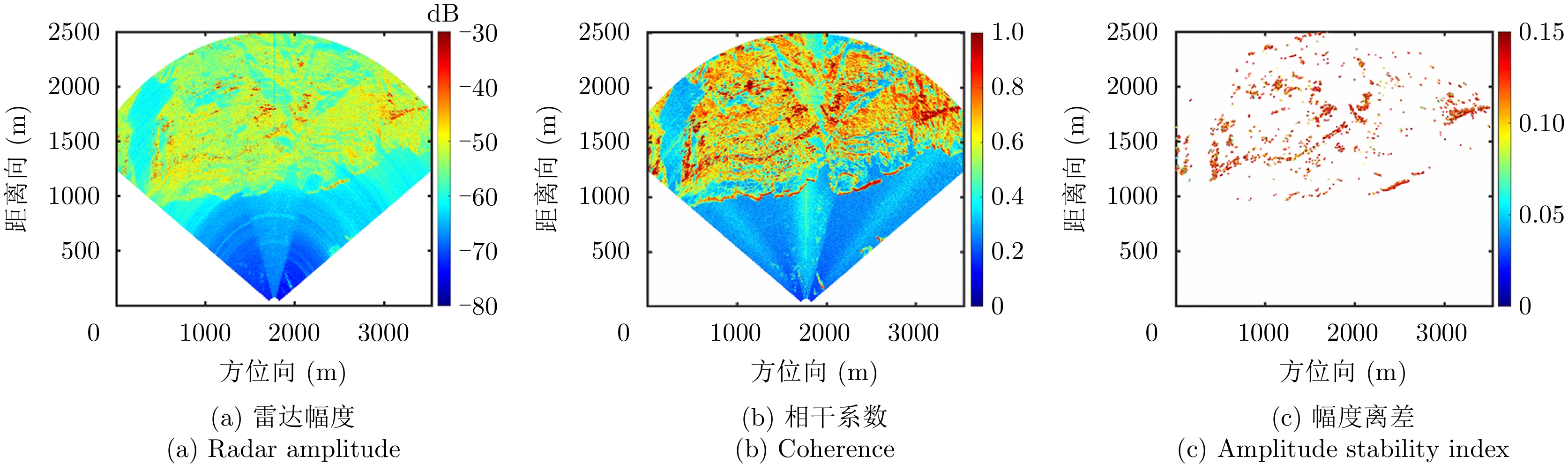
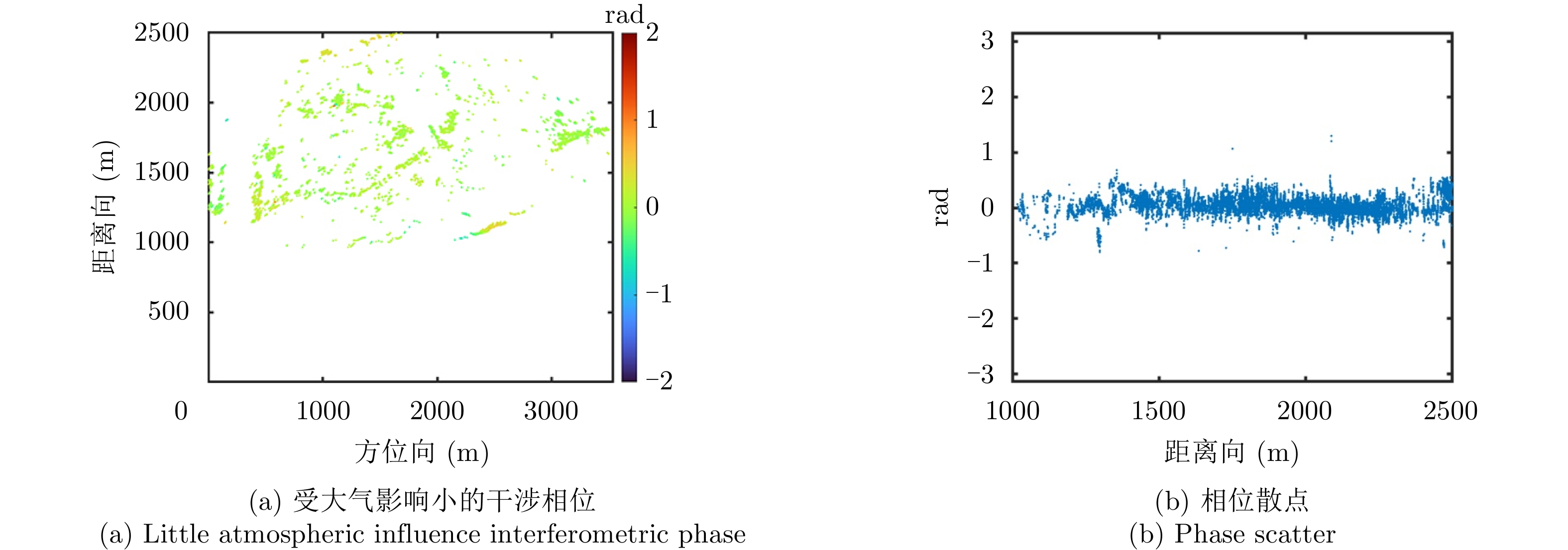
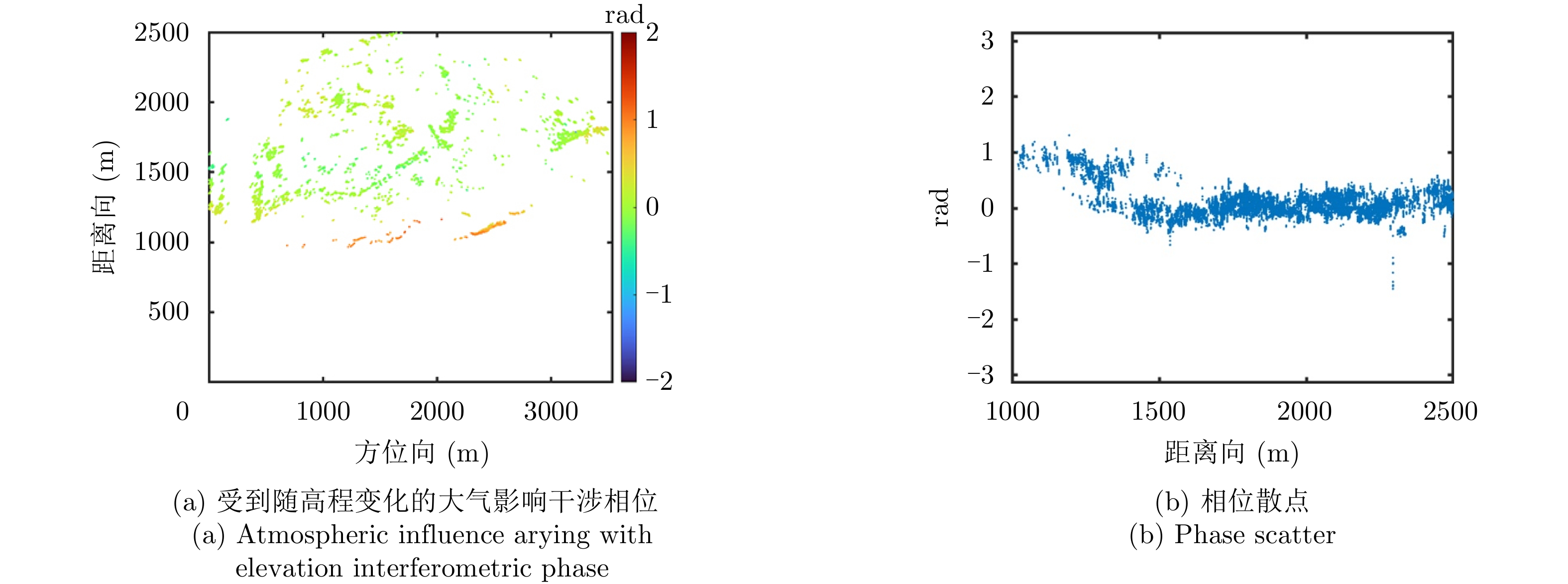
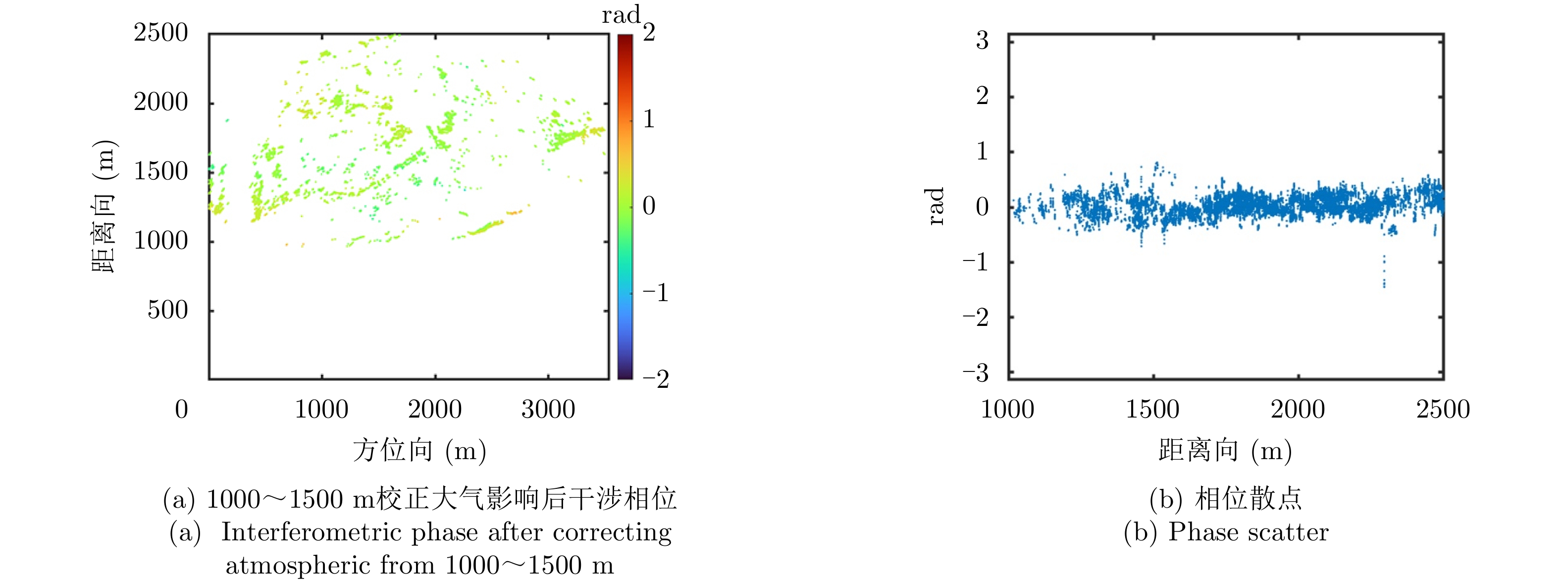
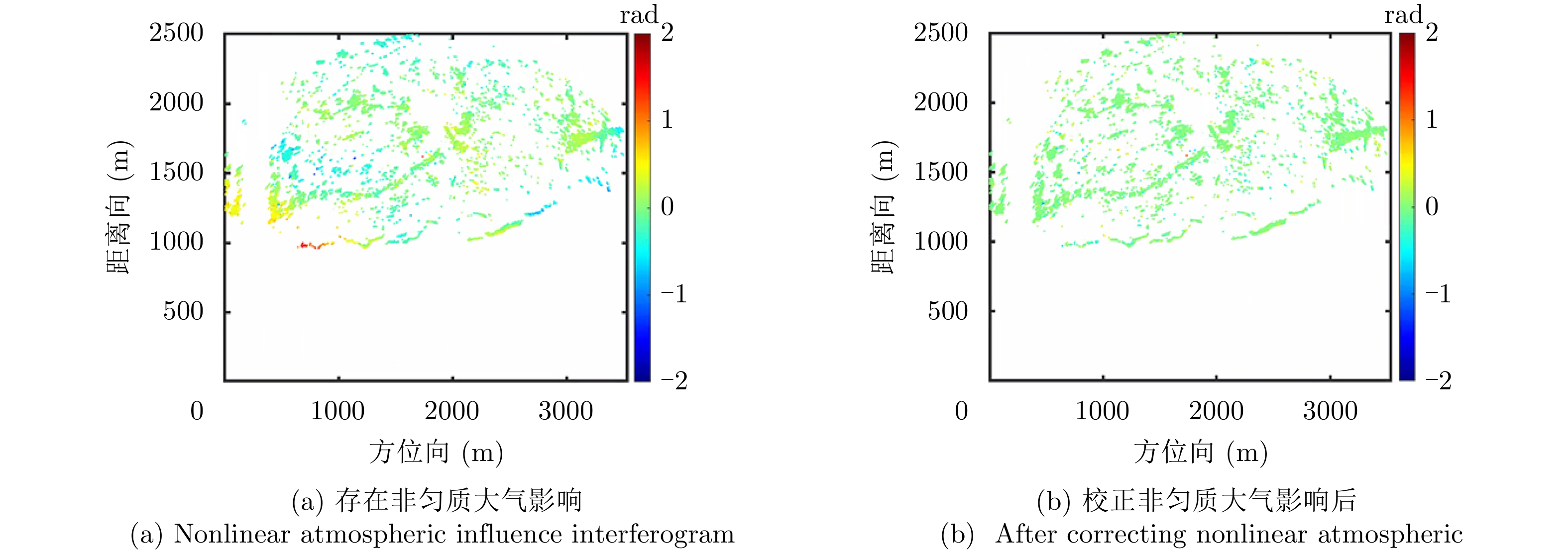
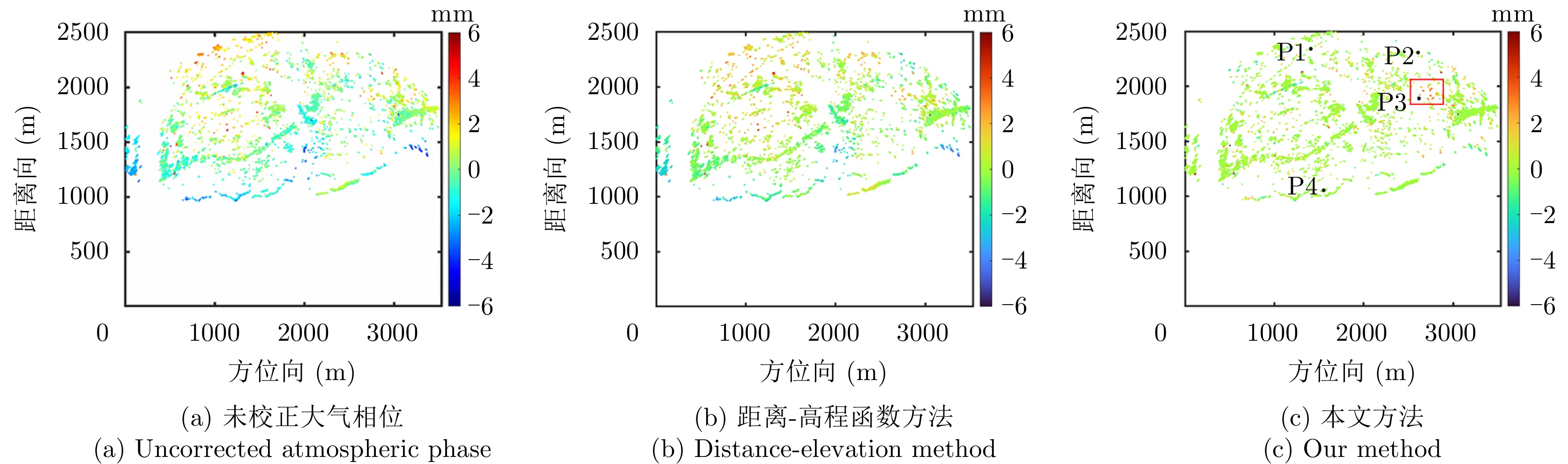
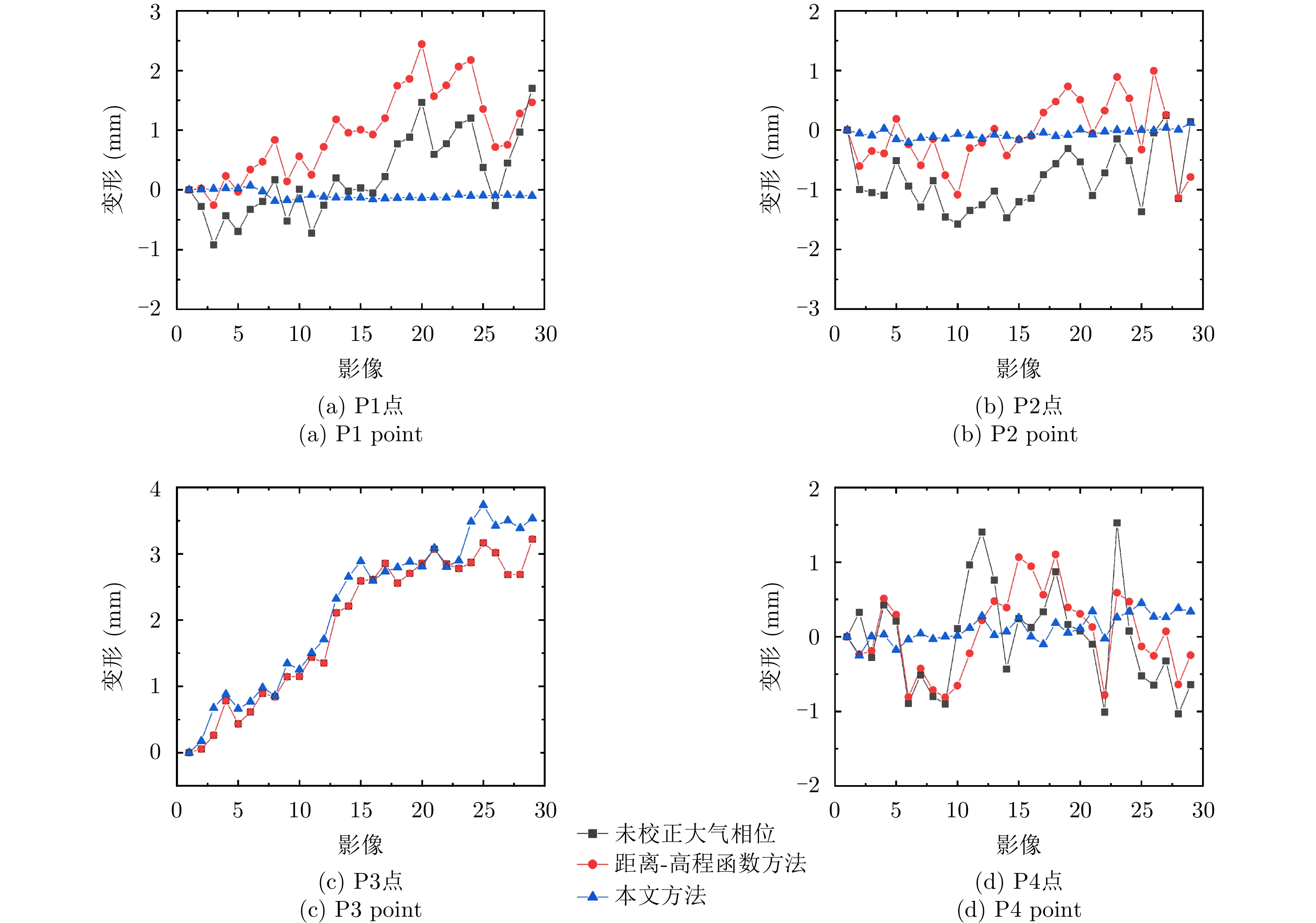
摘要: 大气变化是地基干涉合成孔径雷达(GB-InSAR)形变监测的主要干扰因素。由于监测环境的地形复杂,水汽、湿度和温度的空间异质性,基于均匀大气介质假设的校正方法可能导致大气校正精度较低。该文提出了一种两阶段半经验模型,用于估计和校正复杂大气条件下特大滑坡GB-InSAR监测过程中出现的大气相位误差。该方法兼顾线性大气相位和非线性大气相位,首先根据测区的范围和高程对观测到的大气相位进行建模,校正与地形相关的线性大气相位。然后,考虑复杂大气条件和方位向大视场角度场景下出现的空间域非均匀大气情况,选取稳定永久散射体(PS)通过插值的方式获取所有PS点的大气相位,校正非线性大气相位。采用该方法对三峡库区新铺和藕塘特大滑坡的地基大视场雷达图像进行处理,相比于常规方法减小大气相位误差最大约2 mm。能有效校正特大滑坡监测场景下出现的非均匀大气相位,满足特大滑坡广域范围监测需求。
-
关键词:
- 地基干涉合成孔径雷达 /
- 大气相位校正 /
- 线性变化 /
- 非线性变化 /
- 稳定永久散射体
Abstract: Atmospheric influence is the main interference factor in Ground-Based Interferometric Synthetic Aperture Radar (GB-InSAR) deformation monitoring. Due to the complex terrain and various environmental factors, the correction method based on the assumption of a uniform atmospheric influence may lead to low atmospheric correction accuracy. In this paper, a two-stage semi-empirical model is proposed to correct the atmospheric phase screen during the GB-InSAR monitoring of a super large slope under complex atmospheric conditions. First, the observed atmospheric phase is modeled according to the height and range of the terrain structure to correct the linear atmospheric phase. Then, considering the complex atmospheric conditions and the spatially nonuniform atmosphere with a large azimuth field of view, stable Persistent Scatterers (PS) are selected to obtain the atmospheric phase of all PS by interpolation to correct the nonlinear atmospheric phase. This method is used to process a large field of view radar image of the foundation of the Xinpu and Outang landslides in the Three Gorges Reservoir area. Compared with the conventional method, the atmospheric phase error is reduced by approximately 2 mm. This method effectively corrects the nonuniform atmospheric phase under the landslide monitoring scene and meets the wide-area monitoring needs of the landslide. -
[1] WANG Yanping, HONG Wen, ZHANG Yuan, et al. Ground-based differential interferometry SAR: A review[J]. IEEE Geoscience and Remote Sensing Magazine, 2020, 8(1): 43–70. doi: 10.1109/MGRS.2019.2963169 [2] 刘斌, 葛大庆, 李曼, 等. 地基合成孔径雷达干涉测量技术及其应用[J]. 国土资源遥感, 2017, 29(1): 1–6. doi: 10.6046/gtzyyg.2017.01.01LIU Bin, GE Daqing, LI Man, et al. Ground-based interferometric synthetic aperture radar and its applications[J]. Remote Sensing for Land &Resources, 2017, 29(1): 1–6. doi: 10.6046/gtzyyg.2017.01.01 [3] BAI Zechao, WANG Yanping, and BALZ T. Beijing land subsidence revealed using PS-InSAR with long time series TerraSAR-X SAR data[J]. Remote Sensing, 2022, 14(11): 2529. doi: 10.3390/rs14112529 [4] HU Jun, LIU Jihong, LI Zhiwei, et al. Estimating three-dimensional coseismic deformations with the SM-VCE method based on heterogeneous SAR observations: Selection of homogeneous points and analysis of observation combinations[J]. Remote Sensing of Environment, 2021, 255: 112298. doi: 10.1016/j.rse.2021.112298 [5] RODELSPERGER S. Real-Time Processing of Ground Based Synthetic Aperture Radar (GB-SAR) Measurements[M]. Darmstadt: Technische Universität Darmstadt, 2011. [6] IGLESIAS R, AGUASCA A, FABREGAS X, et al. Ground-based polarimetric SAR interferometry for the monitoring of terrain displacement phenomena–Part I: Theoretical description[J]. IEEE Journal of Selected Topics in Applied Earth Observations and Remote Sensing, 2015, 8(3): 980–993. doi: 10.1109/JSTARS.2014.2360040 [7] PIERACCINI M and MICCINESI L. Ground-based radar interferometry: A bibliographic review[J]. Remote Sensing, 2019, 11(9): 1029. doi: 10.3390/rs11091029 [8] LUZI G, PIERACCINI M, MECATTI D, et al. Ground-based radar interferometry for landslides monitoring: Atmospheric and instrumental decorrelation sources on experimental data[J]. IEEE Transactions on Geoscience and Remote Sensing, 2004, 42(11): 2454–2466. doi: 10.1109/TGRS.2004.836792 [9] NOFERINI L, PIERACCINI M, MECATTI D, et al. Permanent scatterers analysis for atmospheric correction in ground-based SAR interferometry[J]. IEEE Transactions on Geoscience and Remote Sensing, 2005, 43(7): 1459–1471. doi: 10.1109/TGRS.2005.848707 [10] PIPIA L, FABREGAS X, AGUASCA A, et al. Atmospheric artifact compensation in ground-based DInSAR applications[J]. IEEE Geoscience and Remote Sensing Letters, 2008, 5(1): 88–92. doi: 10.1109/LGRS.2007.908364 [11] 徐亚明, 周校, 王鹏, 等. GB-SAR构建永久散射体网改正气象扰动方法[J]. 武汉大学学报:信息科学版, 2016, 41(8): 1007–1012, 1020. doi: 10.13203/j.whugis20140507XU Yaming, ZHOU Xiao, WANG Peng, et al. A method of constructing permanent scatterers network to correct the meteorological disturbance by GB-SAR[J]. Geomatics and Information Science of Wuhan University, 2016, 41(8): 1007–1012, 1020. doi: 10.13203/j.whugis20140507 [12] 黄其欢, 岳建平. 基于稳定点加权的GBSAR大气扰动校正方法[J]. 西南交通大学学报, 2017, 52(1): 202–208. doi: 10.3969/j.issn.0258-2724.2017.01.028HUANG Qihuan and YUE Jianping. GBSAR atmospheric turbulence calibration based on weighted stable points[J]. Journal of Southwest Jiaotong University, 2017, 52(1): 202–208. doi: 10.3969/j.issn.0258-2724.2017.01.028 [13] IANNINI L and GUARNIERI A M. Atmospheric phase screen in ground-based radar: Statistics and compensation[J]. IEEE Geoscience and Remote Sensing Letters, 2011, 8(3): 537–541. doi: 10.1109/LGRS.2010.2090647 [14] IGLESIAS R, FABREGAS X, AGUASCA A, et al. Atmospheric phase screen compensation in ground-based SAR with a multiple-regression model over mountainous regions[J]. IEEE Transactions on Geoscience and Remote Sensing, 2014, 52(5): 2436–2449. doi: 10.1109/TGRS.2013.2261077 [15] KARUNATHILAKE A and SATO M. Atmospheric phase compensation in extreme weather conditions for ground-based SAR[J]. IEEE Journal of Selected Topics in Applied Earth Observations and Remote Sensing, 2020, 13: 3806–3815. doi: 10.1109/JSTARS.2020.3004341 [16] LIU Jie, YANG Honglei, XU Linlin, et al. Novel model-based approaches for non-homogenous atmospheric compensation of GB-InSAR in the azimuth and horizontal directions[J]. Remote Sensing, 2021, 13(11): 2153. doi: 10.3390/rs13112153 [17] HU Cheng, DENG Yunkai, TIAN Weiming, et al. A compensation method for a time-space variant atmospheric phase applied to time-series GB-SAR images[J]. Remote Sensing, 2019, 11(20): 2350. doi: 10.3390/rs11202350 [18] DENG Yunkai, HU Cheng, TIAN Weiming, et al. A grid partition method for atmospheric phase compensation in GB-SAR[J]. IEEE Transactions on Geoscience and Remote Sensing, 2021, 60: 5206713. doi: 10.1109/TGRS.2021.3074161 [19] DENG Yunkai, HU Cheng, TIAN Weiming, et al. 3-D deformation measurement based on three GB-MIMO radar systems: Experimental verification and accuracy analysis[J]. IEEE Geoscience and Remote Sensing Letters, 2021, 18(12): 2092–2096. doi: 10.1109/LGRS.2020.3014342 [20] 胡程, 邓云开, 田卫明, 等. 地基干涉合成孔径雷达图像非线性大气相位补偿方法[J]. 雷达学报, 2019, 8(6): 831–840. doi: 10.12000/JR19073HU Cheng, DENG Yunkai, TIAN Weiming, et al. A compensation method of nonlinear atmospheric phase applied for GB-InSAR images[J]. Journal of Radars, 2019, 8(6): 831–840. doi: 10.12000/JR19073 [21] IZUMI Y, ZOU Lilong, KIKUTA K, et al. Iterative atmospheric phase screen compensation for near-real-time ground-based InSAR measurements over a mountainous slope[J]. IEEE Transactions on Geoscience and Remote Sensing, 2020, 58(8): 5955–5968. doi: 10.1109/TGRS.2020.2973533 [22] FERRETTI A, PRATI C, and ROCCA F. Permanent scatterers in SAR interferometry[J]. IEEE Transactions on Geoscience and Remote Sensing, 2001, 39(1): 8–20. doi: 10.1109/36.898661 [23] ROSEN P A, HENSLEY S, ZEBKER H A, et al. Surface deformation and coherence measurements of Kilauea Volcano, Hawaii, from SIR-C radar interferometry[J]. Journal of Geophysical Research:Planets, 1996, 101(E10): 23109–23125. doi: 10.1029/96JE01459 [24] 肖捷夫. 库水涨落和降雨条件下藕塘滑坡变形演化机制及其预测模型研究[D]. [博士论文], 中国地质大学, 2021.XIAO Jiefu. Deformation evolution mechanism and displacement prediction model of Outang landslide under water level fluctuation and rainfall[D]. [Ph. D. dissertation], China University of Geosciences, 2021. -

 下载:
下载:


图(13)
计量
- 文章访问数:
- HTML全文浏览量:
- PDF下载量:
- 被引次数: 0

