
 作者中心
作者中心 专家审稿
专家审稿 责编办公
责编办公 编辑办公
编辑办公
See-Earth: SAR Constellation with Dense Time-SEries for Multi-dimensional Environmental Monitoring of the Earth
-
摘要: 我国星载合成孔径雷达(SAR)面临着卫星通用性、应用维度与深度以及广域观测效能等局限性,缺少面向全球并实现长期、稳定、高性能环境动态监测的卫星系统。随着国际环境日趋复杂,我国亟需发展面向全球动态环境监测的SAR卫星系统,实现大范围、高重访、长期、稳定、高精度的对地观测。该文提出一个高频时序多维地球环境监测SAR星座(简称See-Earth)计划,从系统构想、技术体制、性能分析、应用潜力以及新体制扩展几方面来进行探讨。
-
关键词:
- 星载合成孔径雷达(SAR) /
- See-Earth计划 /
- 高分辨率宽幅 /
- 极化SAR /
- 高重访
Abstract: The limitations of satellite versatility, application dimensions, and wide-area observation efficiency are major issues impeding the development of Chinese spaceborne Synthetic Aperture Radar (SAR). China lacks a satellite system that can realize long-term, stable, and high-performance environmental dynamic monitoring oriented to the world. As the international environment becomes increasingly complex, China urgently needs to develop a SAR satellite system for global dynamic environmental monitoring to achieve large-scale, high-revisit, long-term, stable, and high-precision observations. This paper proposes a SAR Constellation with Dense Time-S E ries for MultiDimensional E nvironmental Monitoring of the Earth (See-Earth) plan. In addition, the system conception, technical architectures, performance analysis, application potential, and new system expansion are discussed. -
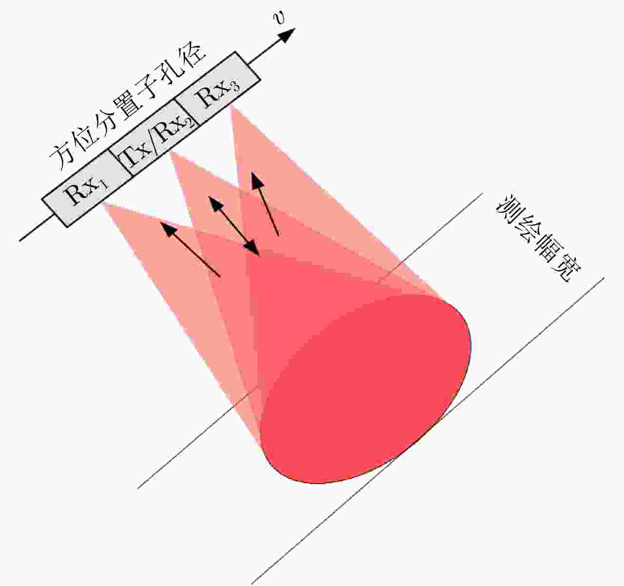
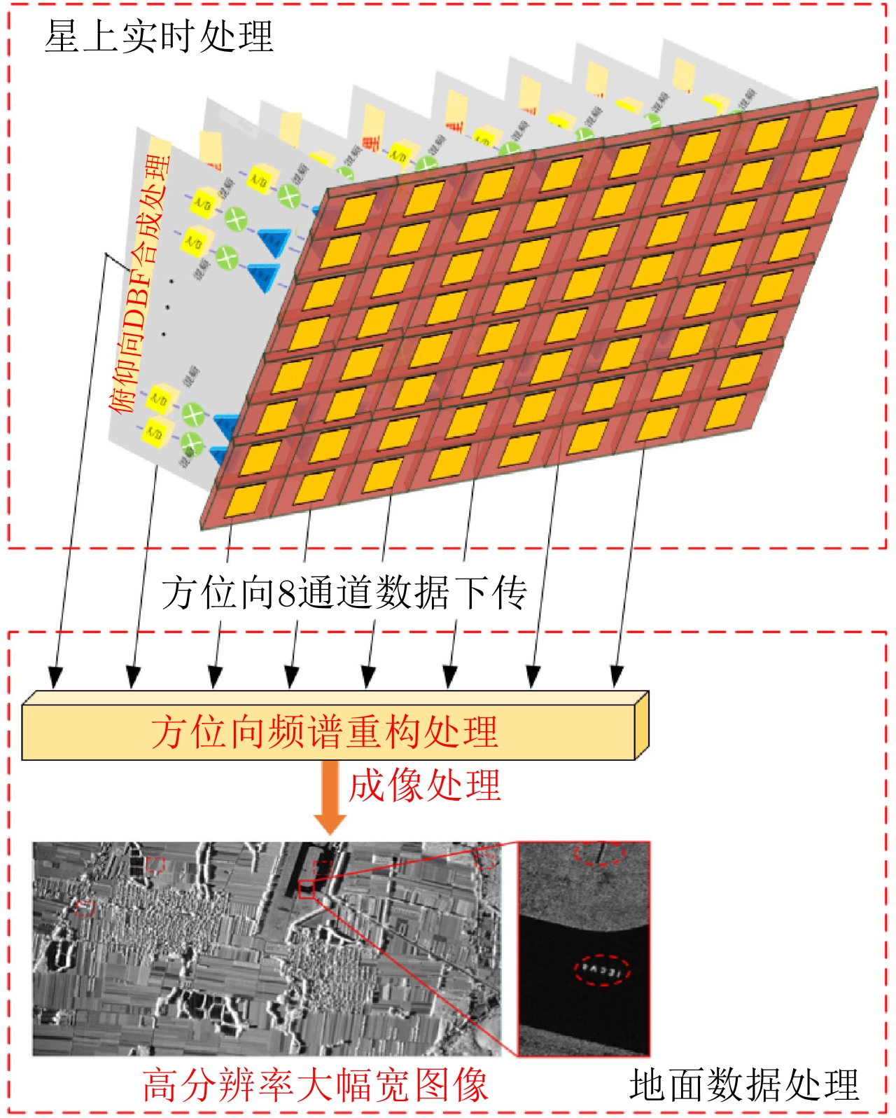
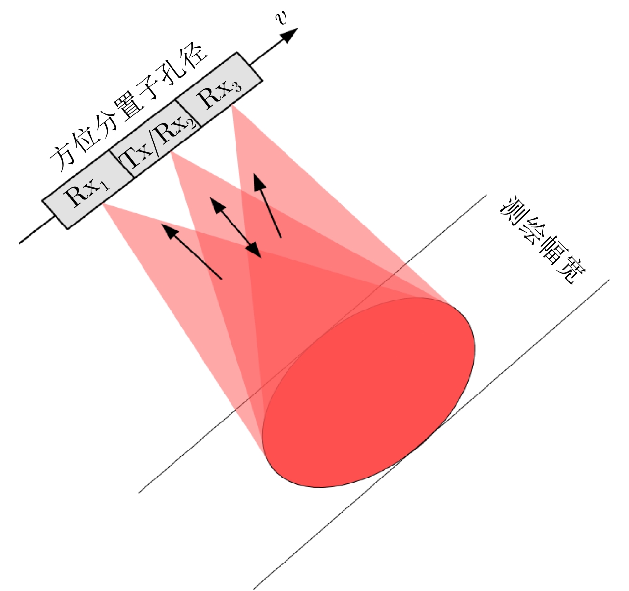
图 8 方位多通道系统信号收发示意图
Figure 8. Schematic diagram for the signal transmission and reception of the azimuth multi-channel system
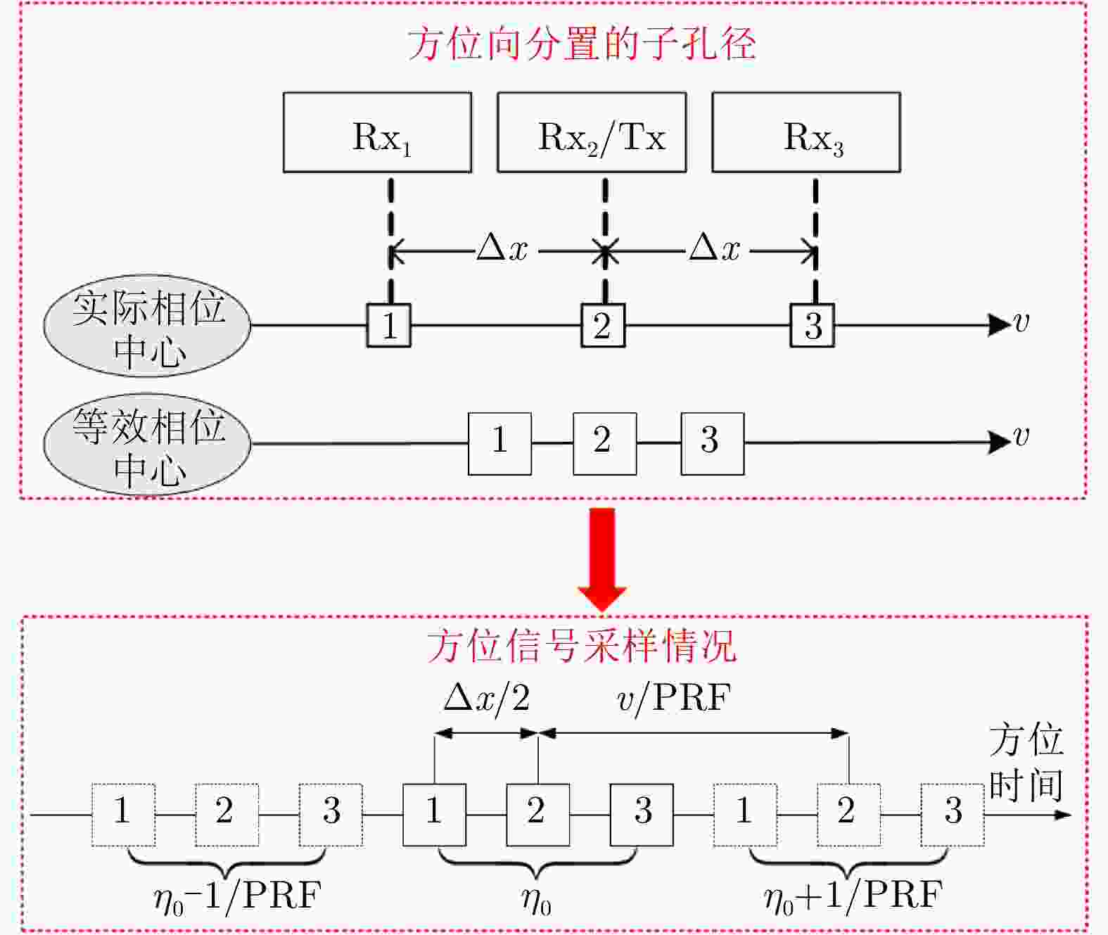
图 9 方位向多通道系统的等效相位中心与信号采样情况
Figure 9. The equivalent phase center and signal sampling situation of the azimuth multi-channel system
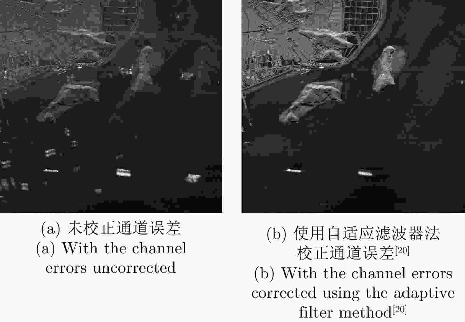
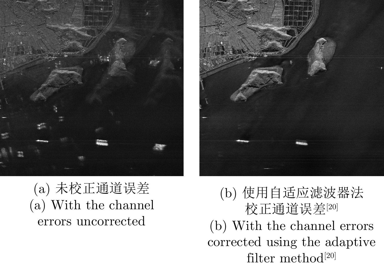
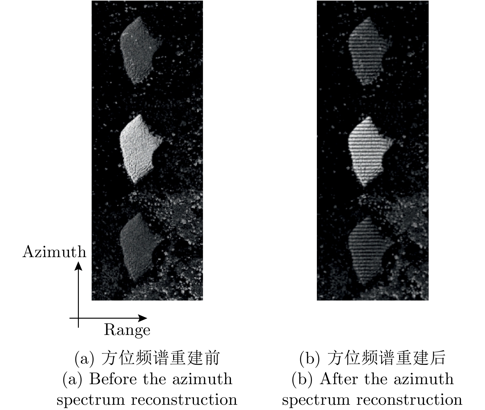
图 10 方位多通道数据重建后成像结果
Figure 10. The imaging results after azimuth multi-channel reconstruction
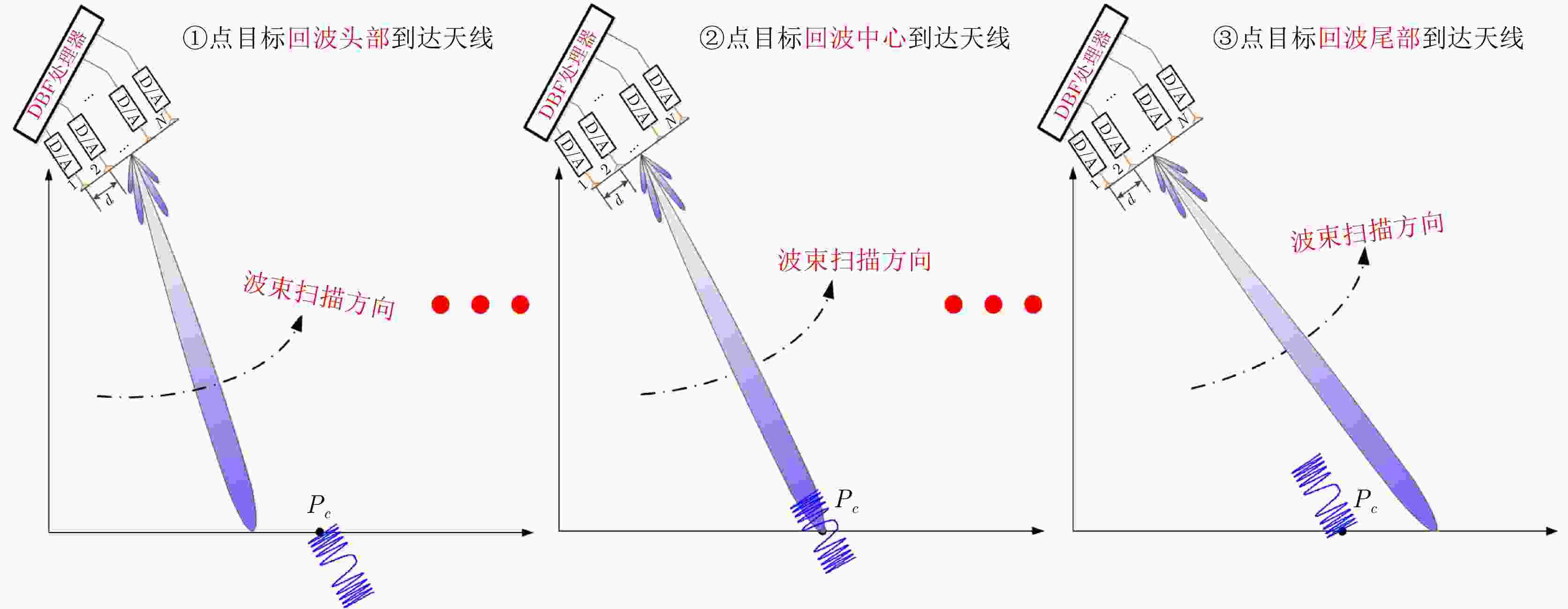
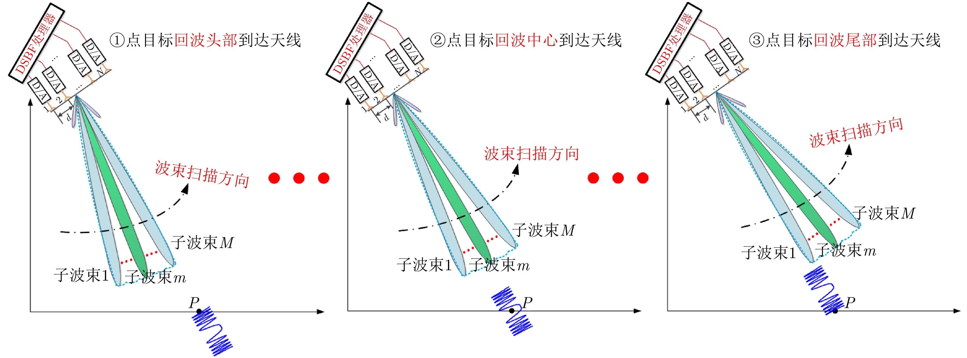
图 12 单点目标回波的扫描接收示意图
Figure 12. Schematic diagram for the echo scanning and receiving of a single-point target
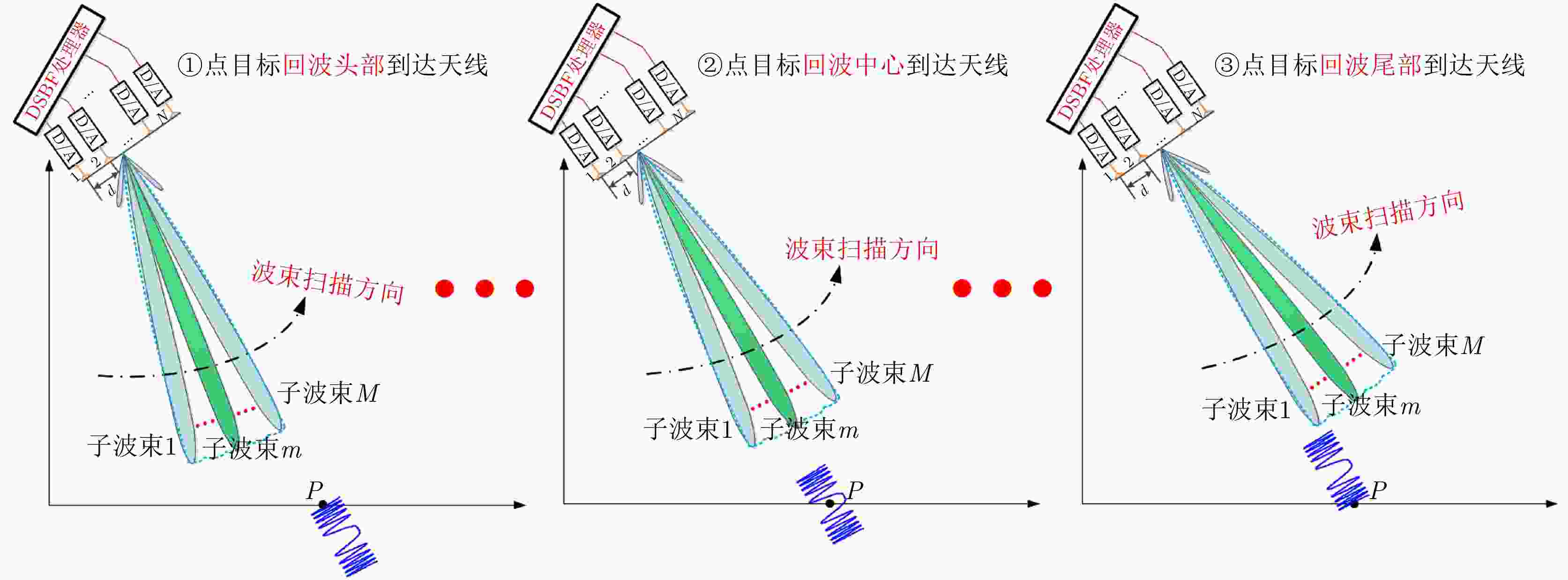
图 13 DSBF处理器单点目标回波的扫描接收示意图
Figure 13. Schematic diagram for the echo scanning and receiving of a single-point target using the DSBF processor


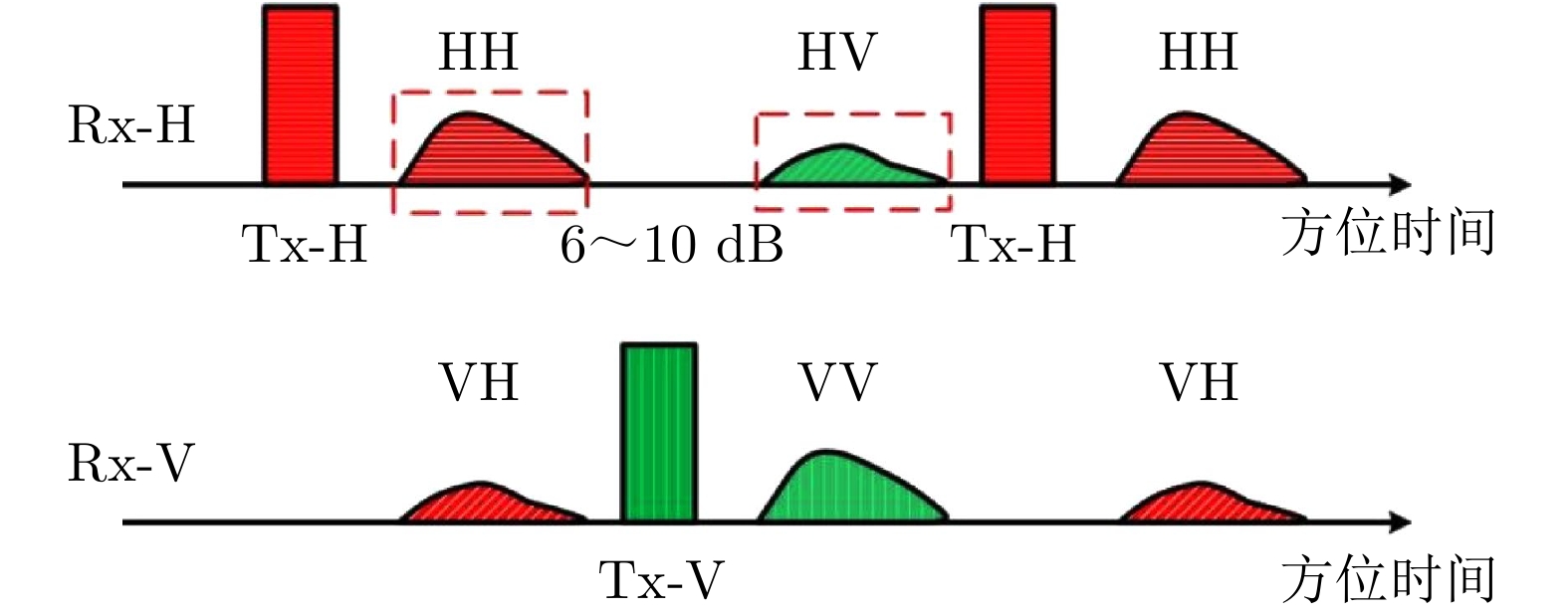
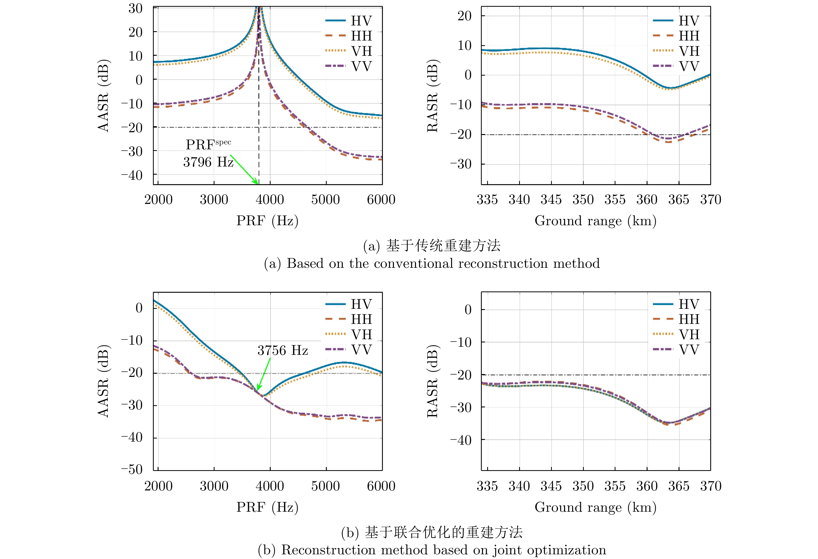
图 16 传统线全极化SAR系统时序图
Figure 16. The timing diagram of conventional quadrature polarimetric SAR system
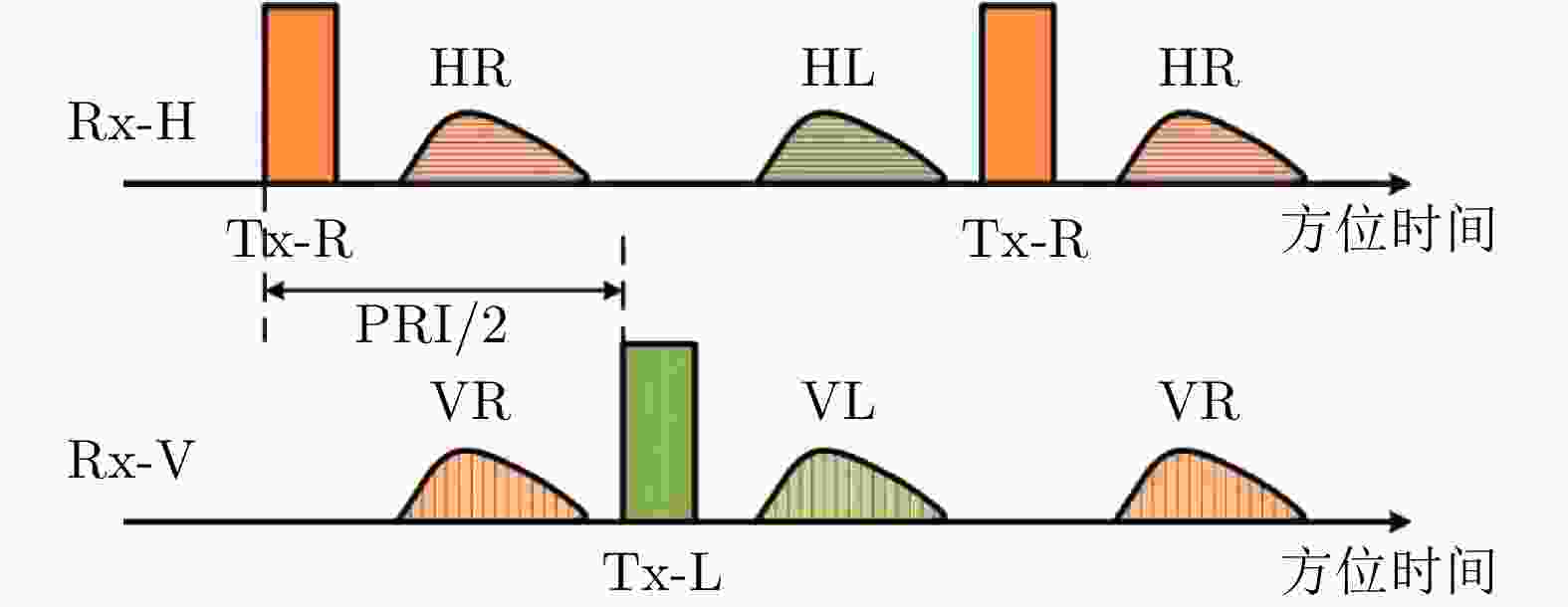
图 17 混合全极化SAR系统时序图(左右旋圆极化)
Figure 17. The timing diagram of hybrid quadrature polarimetric SAR system (left and right circular polarization)
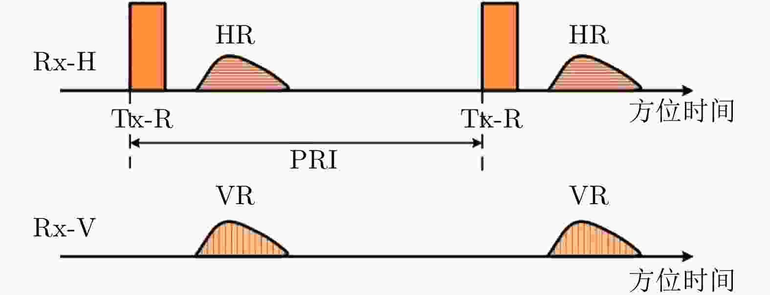
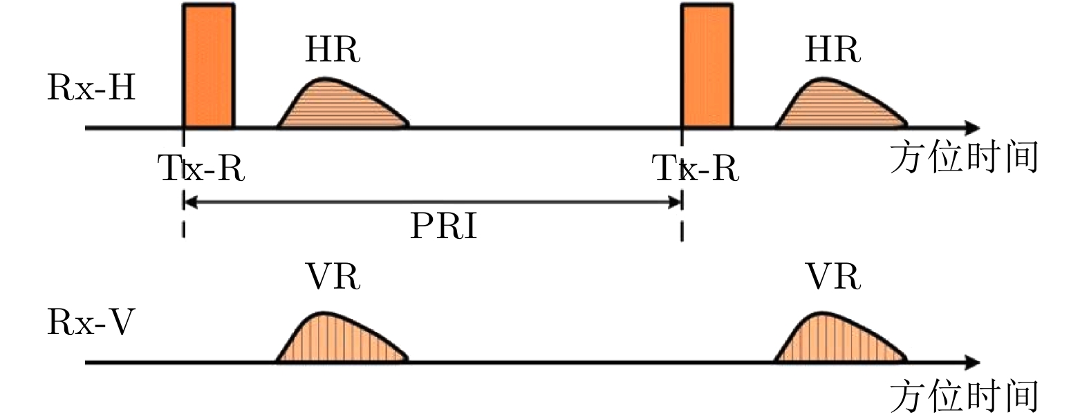
图 18 混合简缩极化SAR系统时序图(右旋圆极化发射)
Figure 18. The timing diagram of hybrid compact polarimetric SAR system (right circular polarization transmission)
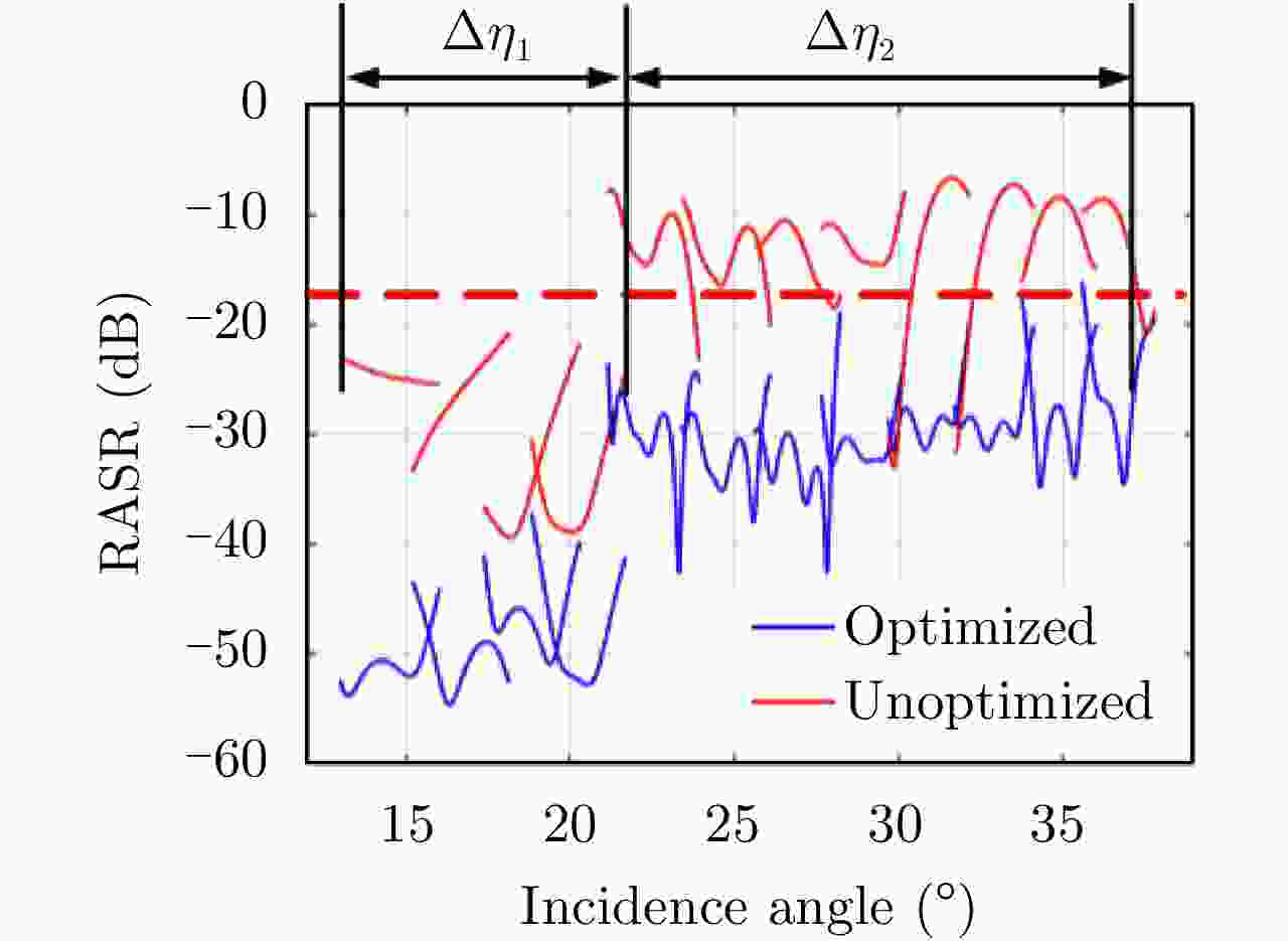
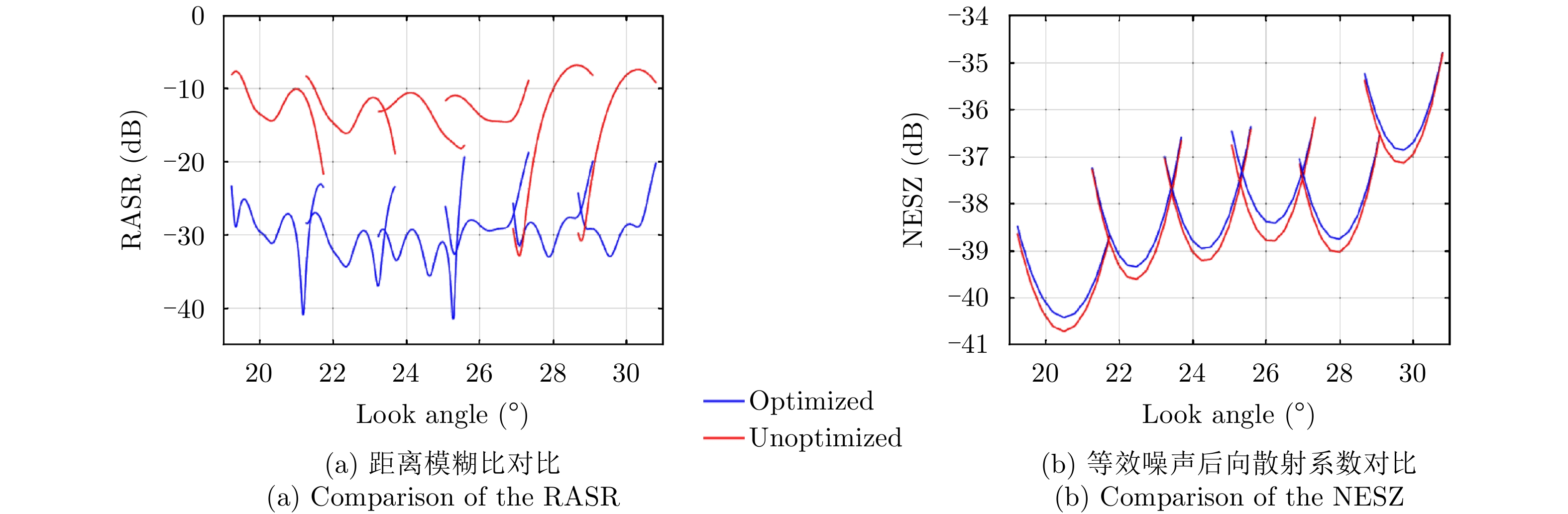
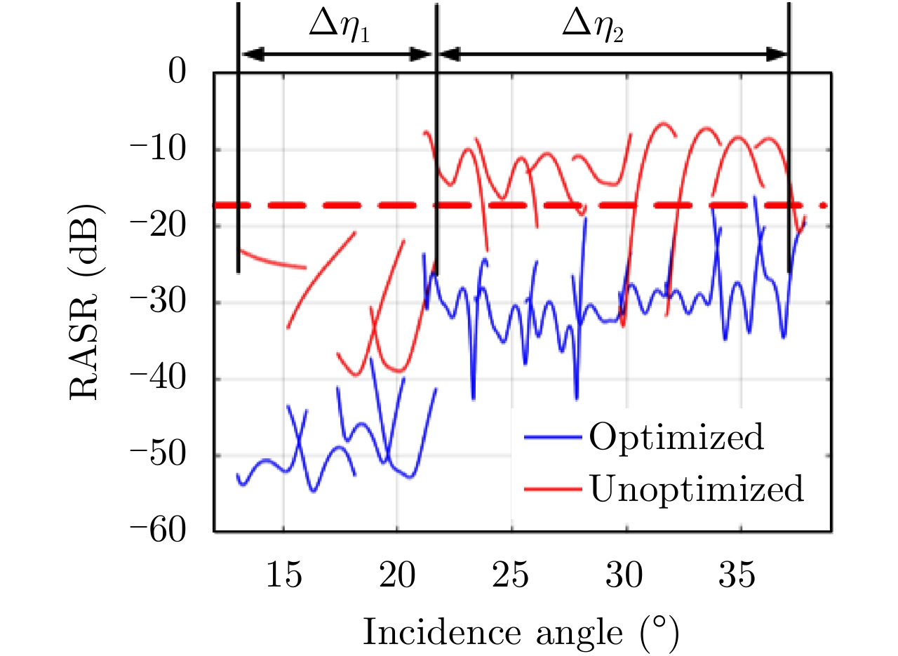
图 22 LT-1优化前后有效观测范围对比
Figure 22. Comparison of the effective observation range before and after LT-1 optimization
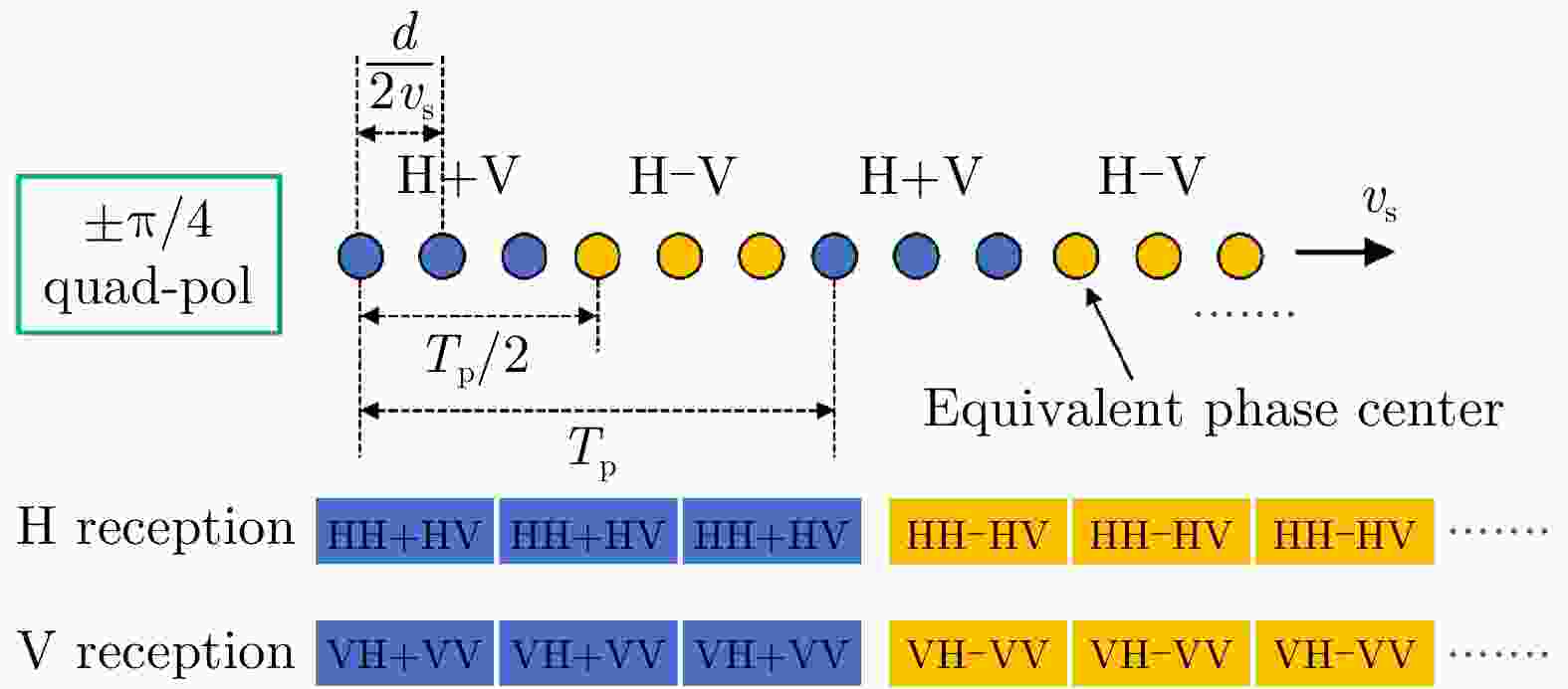
图 23 方位向三通道混合全极化SAR系统的等效相位中心示意图
Figure 23. Schematic diagram of the equivalent phase center of the azimuth three-channel hybrid four-polarized SAR system

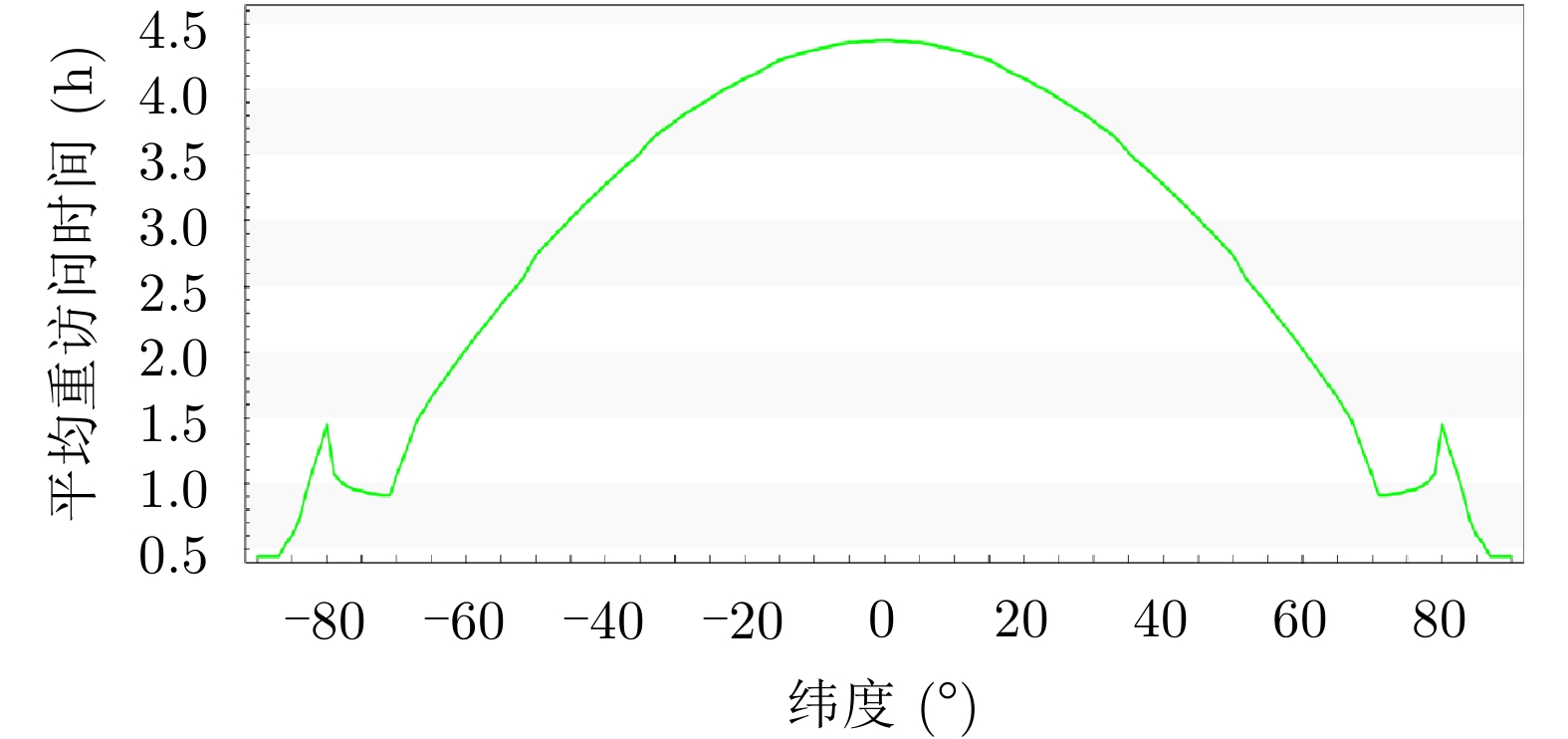
图 27 See-Earth星座全球平均重访时间
Figure 27. The global average revisit time of the See-Earth plan
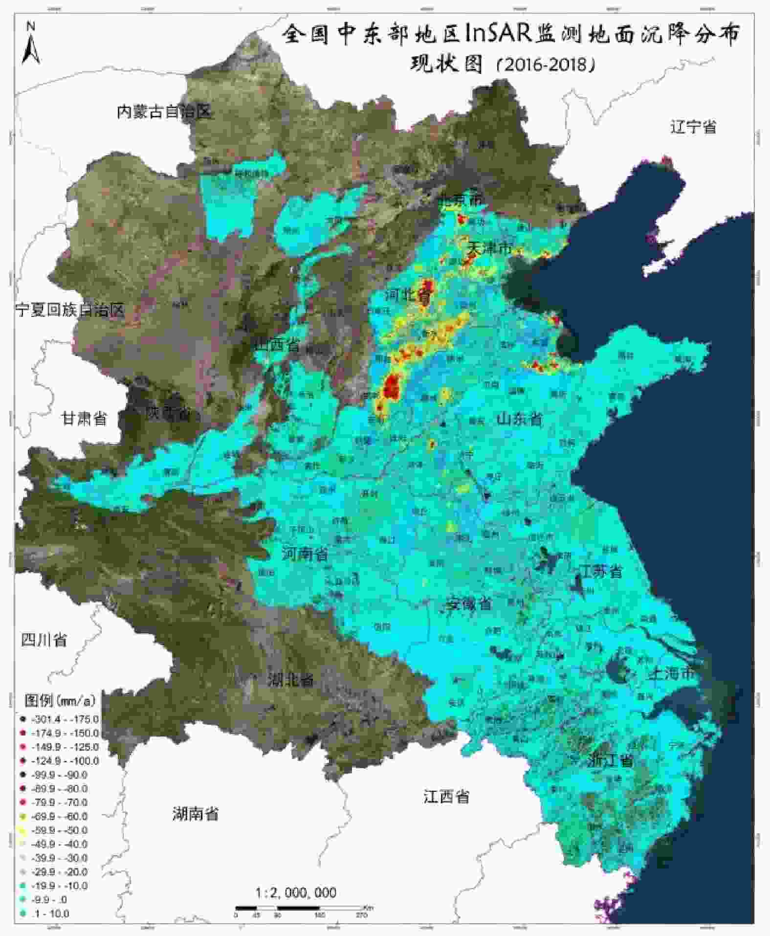
图 28 全国中东部地区InSAR监测地面沉降分布(来源:中国自然资源航空物探遥感中心)
Figure 28. Land subsidence distribution monitored by InSAR in the central and eastern regions of the China (Source: Aero Geophysical Survey & Remote Sensing Center, Ministry of Land and Resources)
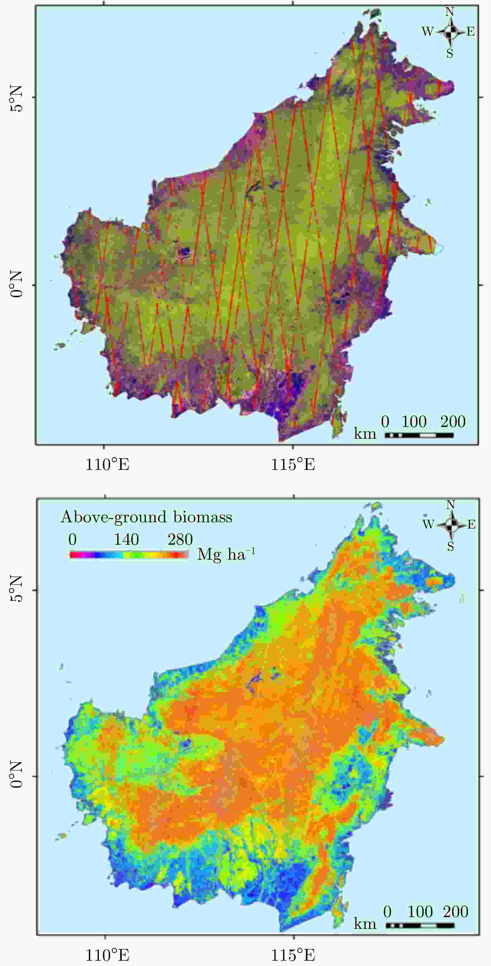
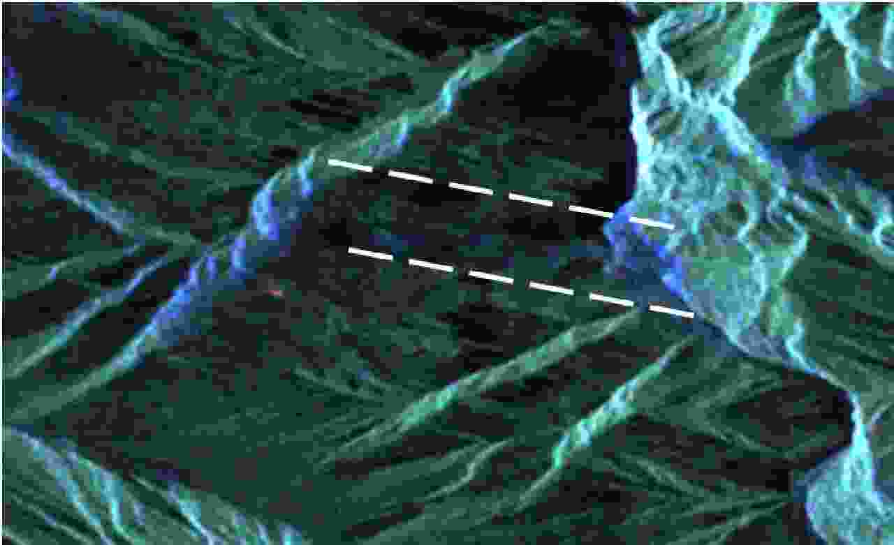
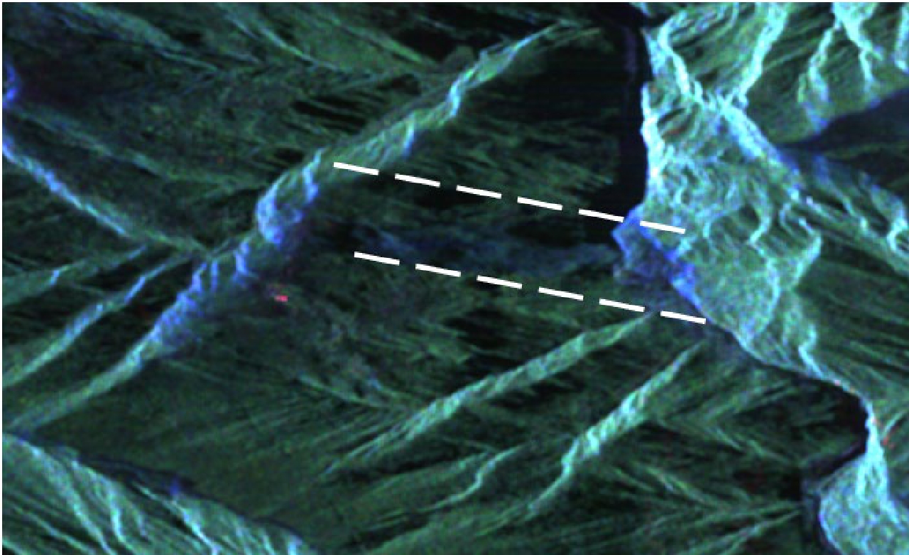
图 31 滑坡区域灾后的极化分解伪彩色合成图(2018年10月12日)
Figure 31. Pseudo-color composite image of polarization decomposition after the disaster in the landslide area (October 12, 2018)
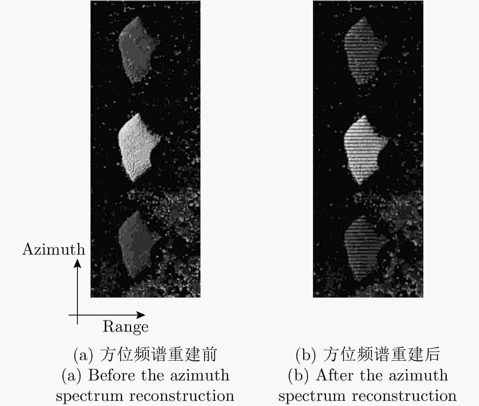
表 1 See-Earth主要系统指标
Table 1. Main system indicators of the See-Earth plan
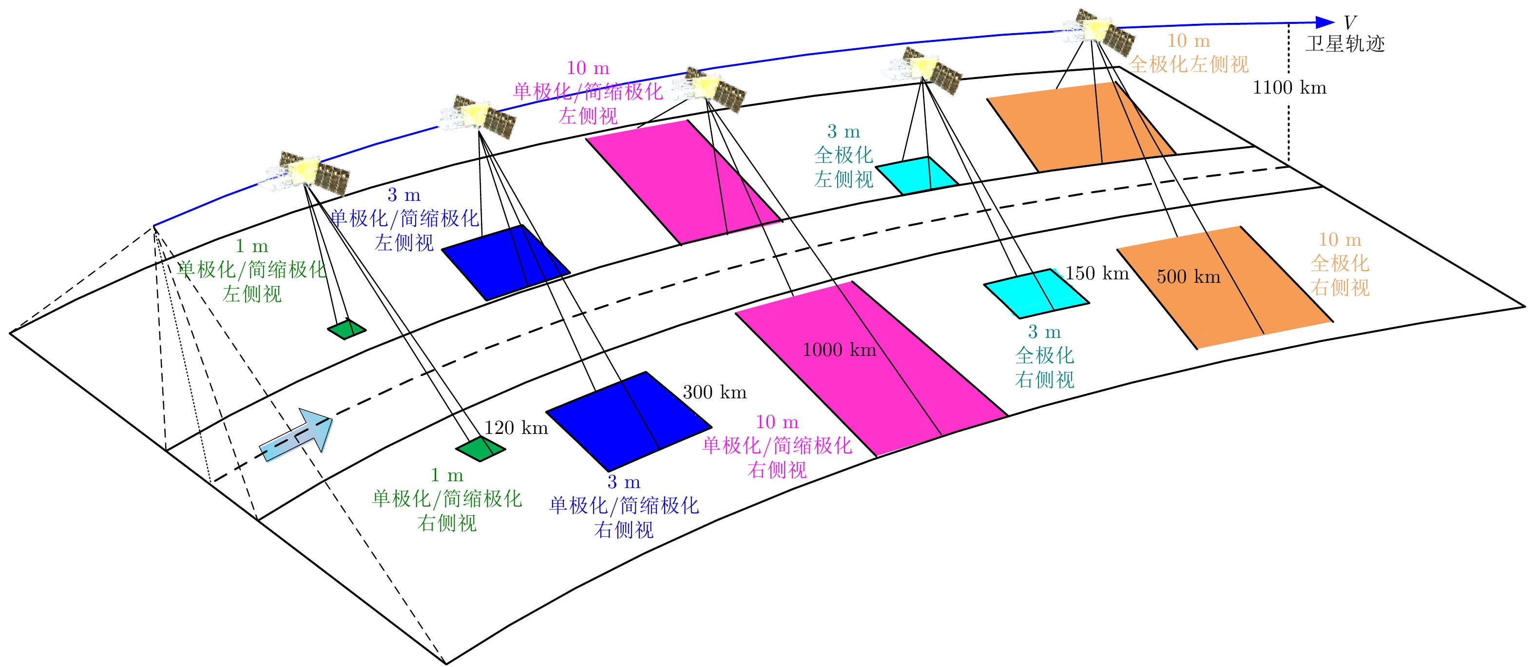
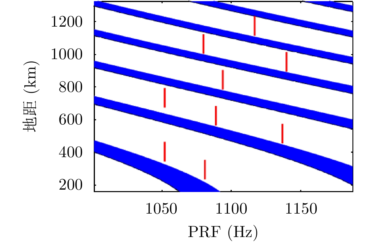
指标 取值 轨道高度 1100 km 回归周期 2天(单星8天) 星座卫星数 4颗 频段 L波段 主要工作模式 1 m/120 km(单极化/简缩极化)
3 m/300 km(单极化/简缩极化)
3 m/150 km(全极化)
10 m/1000 km(单极化/简缩极化)
10 m/500 km(全极化)天线重量 510 kg 中央电子设备重量 80 kg 载荷总重量 ≤830 kg 功耗 <13500 W 占空比 约13% 数据率 <12 Gbps  下载: 导出CSV
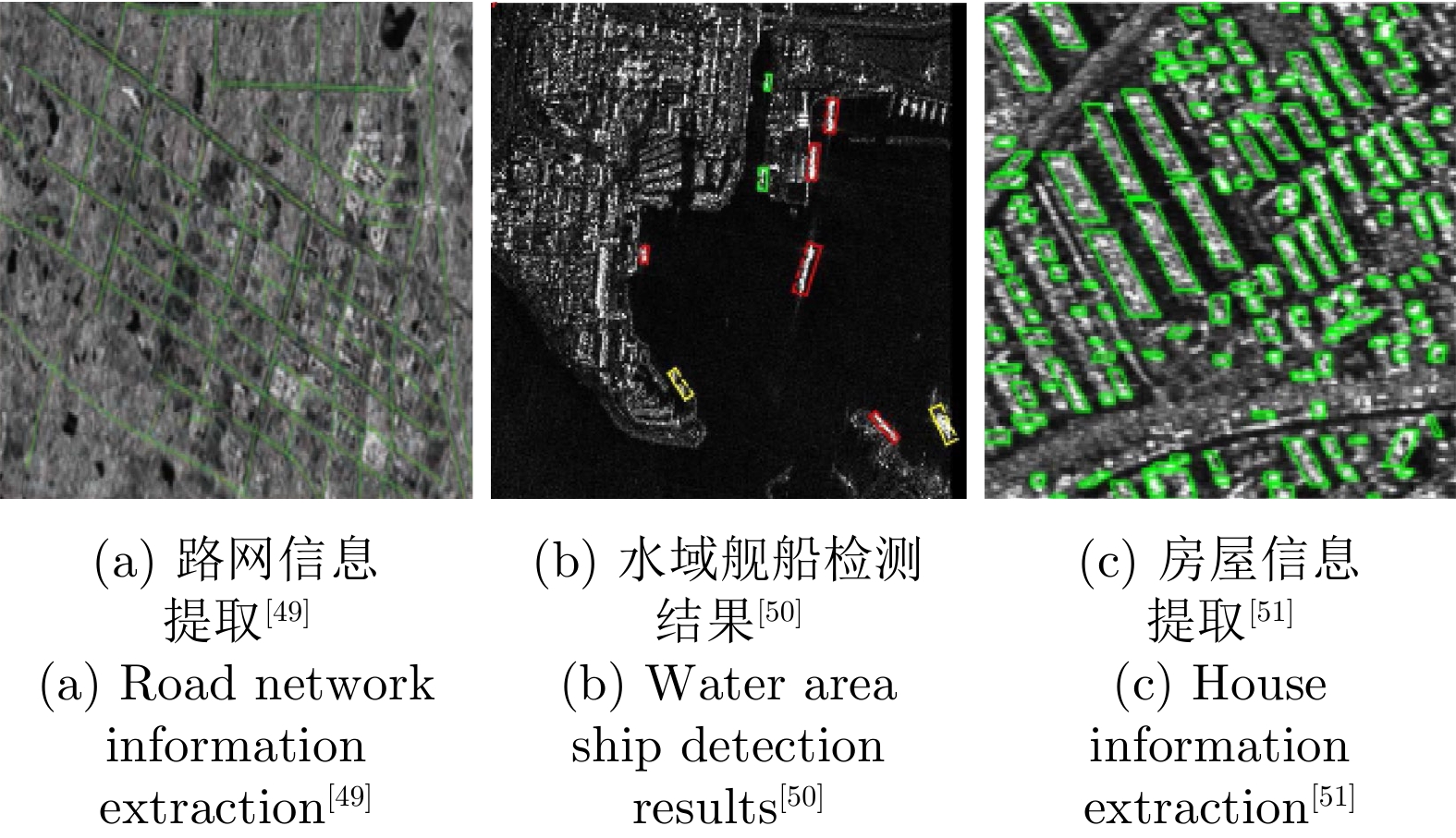
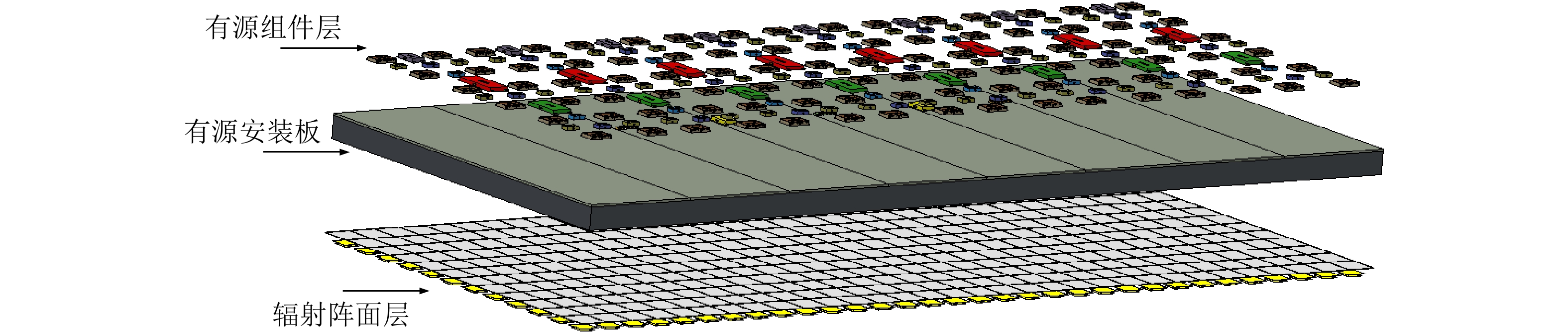
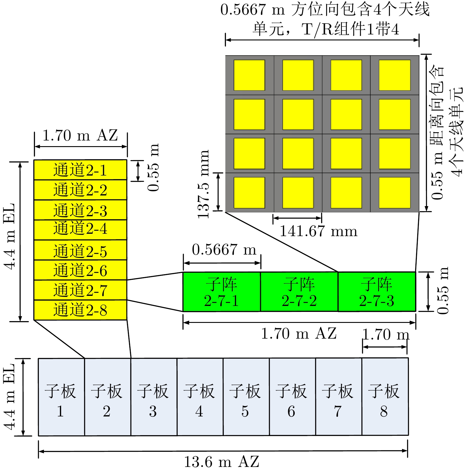
表 2 天线主要参数
Table 2. Main parameters of the antenna
参数 取值 中心频率 1.257 GHz 工作带宽 最大84 MHz (应急可拓展300 MHz) 通道数 8(方位向)×8(距离向) 天线尺寸 13.6 m(方位向)×4.4 m(距离向) 单位面积重量 约8.5 kg/m² 波束扫描范围 距离向±20º 波束宽度 方位向: 0.90°;距离向: 2.76°
下载: 导出CSV
表 3 See-Earth卫星轨道参数
Table 3. Orbit parameters of the See-Earth satellite
参数 取值 轨道类型 太阳同步轨道 轨道倾角 98° 轨道偏心率 0 近地点倾角 90° 轨道半长轴 7489 km 升交点时间 6:00 AM,晨昏成像 平近点角 0°/90°/180°/270°
下载: 导出CSV
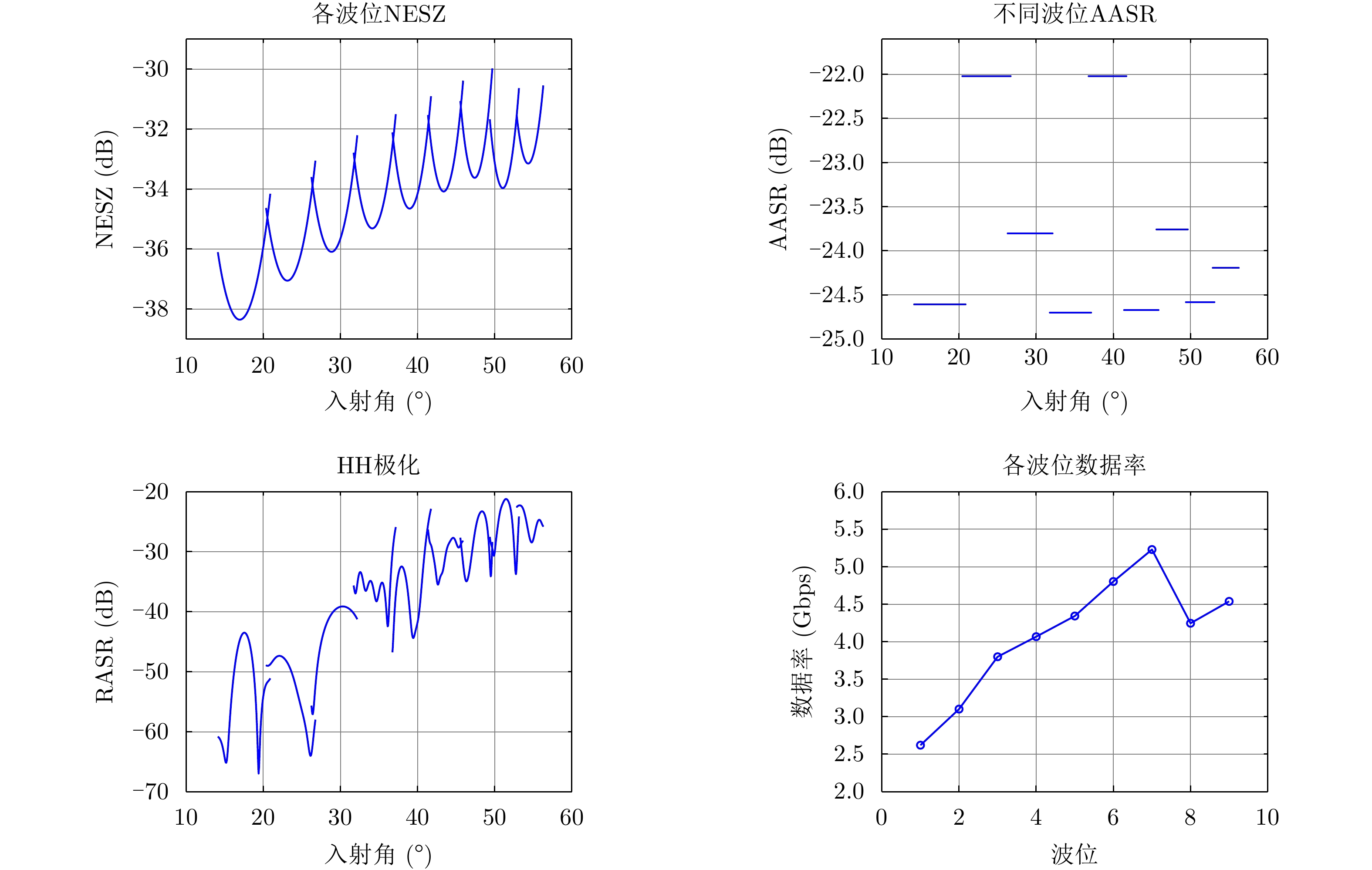
表 4 各工作模式性能
Table 4. Performance of each operation mode
工作模式 性能指标 仿真结果 1 m/120 km
单极化/简缩极化最差NESZ –29.98 dB 最差AASR –22.02 dB 最差RASR –21.22 dB 最大数据率 5.23 Gbps(单极化)
10.46 Gbps(简缩极化)3 m/300 km
单极化/简缩极化最差NESZ –29.87 dB 最差AASR –21.10 dB 最差RASR –22.01 dB 最大数据率 5.52 Gbps(单极化)
11.04 Gbps(简缩极化)3 m/150 km
全极化最差NESZ –28.96 dB 最差AASR –21.12 dB 最差RASR –22.36 dB(同极化)
–16.36 dB(交叉极化)最大数据率 10.84 Gbps 10 m/1000 km
单极化/简缩极化最差NESZ –32.45 dB 最差AASR –21.52 dB 最差RASR –21.28 dB 最大数据率 2.76 Gbps(单极化)
5.52 Gbps(简缩极化)10 m/500 km
全极化最差NESZ –31.46 dB 最差AASR –21.61 dB 最差RASR –21.53 dB(同极化)
–17.21 dB(交叉极化)最大数据率 5.75 Gbps
下载: 导出CSV
表 5 See-Earth观测能力
Table 5. See-Earth observation capability
工作模式:极化/分辨率/幅宽 图像重叠率 全球覆盖时间 (d)* 全国覆盖时间(90%) (h)* 局部区域覆盖时间 1:单极化/简缩极化1 m/120 km >10% 12 72 2小时覆盖北京地区 2:全极化3 m/150 km >10% 10 60 3:单极化/简缩极化3 m/300 km >10% 5 36 2小时覆盖华北地区 4: 全极化10 m/500 km >10% 4 24 5:单极化/简缩极化10 m/1000 km >10% 2 4 *全球覆盖时间:每轨开机时间假定为30 min;全国覆盖时间:同时考虑升降轨覆盖。
下载: 导出CSV
表 6 See-Earth产品观测性能
Table 6. The observation performance of See-Earth product
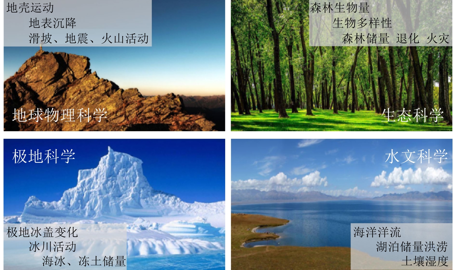
应用潜力 应用技术需求 See-Earth产品 高程测量与地表形变监测 高频次时序干涉 ● 高精度DEM数据
● 每2天可实现对观测区域的回归服务国家重大工程 高频次高精度广域观测 ● 8天覆盖@1 m/120 km
● 1天覆盖@10 m/1000 km
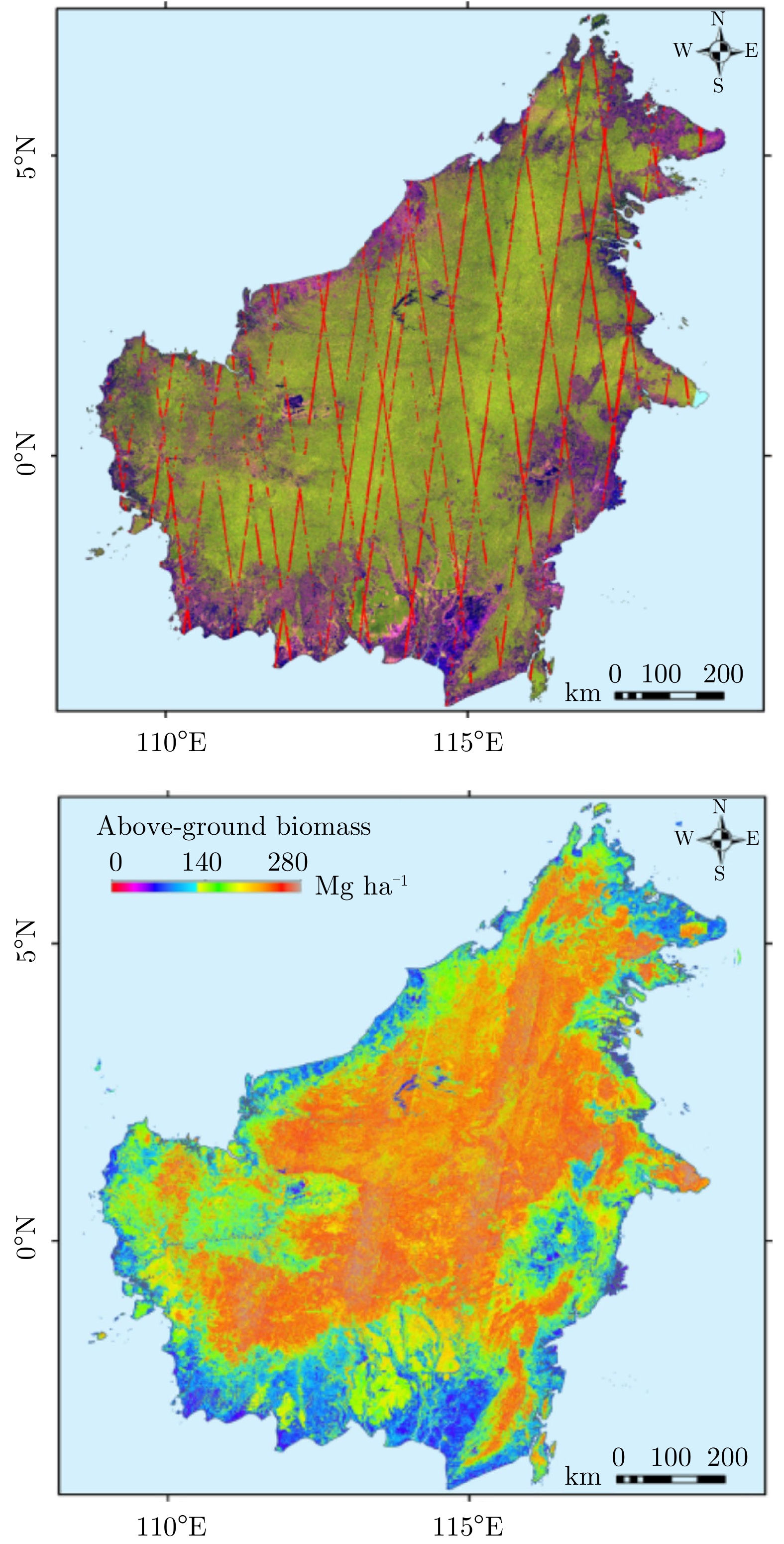
● 星座平均重访3 h自然资源动态监测 森林生物量、地物分类 ● 高精度全极化数据
● 观测模式:3 m/150 km全极化,10 m/500 km全极化应急管理 极化干涉、高频次重访、滑坡形变监测 ● 间隔2天可获取重复观测干涉数据
● 星座平均重访3 h,最快重访时间25 min
● 观测模式:3 m/150 km全极化,10 m/500 km全极化交通、水利、住建等行业 高分辨率动态观测 ● 星座平均重访3 h,最快重访时间25 min
● 观测模式:1 m/120 km地球科学 形变、生物量、应用 全部
下载: 导出CSV
-
[1] 邓云凯, 禹卫东, 张衡, 等. 未来星载SAR技术发展趋势[J]. 雷达学报, 2020, 9(1): 1–33. doi: 10.12000/JR20008DENG Yunkai, YU Weidong, ZHANG Heng, et al. Forthcoming spaceborne SAR development[J]. Journal of Radars, 2020, 9(1): 1–33. doi: 10.12000/JR20008 [2] 杨魁, 杨建兵, 江冰茹. Sentinel-1卫星综述[J]. 城市勘测, 2015(2): 24–27. doi: 10.3969/j.issn.1672-8262.2015.02.006YANG Kui, YANG Jianbing, and JIANG Bingru. Sentinel-1 satellite overview[J]. Urban Geotechnical Investigation &Surveying, 2015(2): 24–27. doi: 10.3969/j.issn.1672-8262.2015.02.006 [3] MOREIRA A, KRIEGER G, HAJNSEK I, et al. Tandem-L: A highly innovative bistatic SAR mission for global observation of dynamic processes on the earth’s surface[J]. IEEE Geoscience and Remote Sensing Magazine, 2015, 3(2): 8–23. doi: 10.1109/MGRS.2015.2437353 [4] Rosen P. Planned data products and science processing paradigm for the proposed NASA-ISRO SAR mission[J]. Journal of Computational Chemistry, 2014, 5(5): 486–499. [5] MOTOHKA T, KANKAKU Y, MIURA S, et al. Alos-4 L-band SAR mission and observation[C]. IGARSS 2019 - 2019 IEEE International Geoscience and Remote Sensing Symposium, Yokohama, Japan, 2019: 5271–5273. doi: 10.1109/IGARSS.2019.8898169. [6] KRIEGER G, GEBERT N, and MOREIRA A. Unambiguous SAR signal reconstruction from nonuniform displaced phase center sampling[J]. IEEE Geoscience and Remote Sensing Letters, 2004, 1(4): 260–264. doi: 10.1109/LGRS.2004.832700 [7] KRIEGER G, GEBERT N, and MOREIRA A. SAR signal reconstruction from non-uniform displaced phase centre sampling[C]. IGARSS 2004-2004 IEEE International Geoscience and Remote Sensing Symposium, Anchorage, USA, 2004: 1763–1766. [8] JING Wei, XING Mengdao, QIU Chengwei, et al. Unambiguous reconstruction and high-resolution imaging for multiple-channel SAR and airborne experiment results[J]. IEEE Geoscience and Remote Sensing Letters, 2009, 6(1): 102–106. doi: 10.1109/LGRS.2008.2008825 [9] ZHAO Shuo, WANG R, DENG Yunkai, et al. Modifications on multichannel reconstruction algorithm for SAR processing based on periodic nonuniform sampling theory and nonuniform fast Fourier transform[J]. IEEE Journal of Selected Topics in Applied Earth Observations and Remote Sensing, 2015, 8(11): 4998–5006. doi: 10.1109/JSTARS.2015.2421303 [10] FAN Feng, DANG Hongxing, TAN Xiaomin, et al. An improved scheme of Digital Beam-Forming in elevation for spaceborne SAR[C]. IET International Radar Conference 2013, Xi’an, China, 2013: 1–6. [11] WANG Wei, WANG R, DENG Yunkai, et al. An improved processing scheme of digital beam-forming in elevation for reducing resource occupation[J]. IEEE Geoscience and Remote Sensing Letters, 2016, 13(3): 309–313. doi: 10.1109/LGRS.2015.2508098 [12] GEBERT N, KRIEGER G, and MOREIRA A. Digital beamforming on receive: Techniques and optimization strategies for high-resolution wide-swath SAR imaging[J]. IEEE Transactions on Aerospace and Electronic Systems, 2009, 45(2): 564–592. doi: 10.1109/TAES.2009.5089542 [13] ZHAO Qingchao, ZHANG Yi, WANG Wei, et al. On the frequency dispersion in DBF SAR and digital scalloped beamforming[J]. IEEE Transactions on Geoscience and Remote Sensing, 2020, 58(5): 3619–3632. doi: 10.1109/TGRS.2019.2958863 [14] ZHOU Yashi, WANG Wei, CHEN Zhen, et al. Digital Beamforming synthetic aperture radar (DBSAR): Experiments and performance analysis in support of 16-channel airborne X-band SAR data[J]. IEEE Transactions on Geoscience and Remote Sensing, 2021, 59(8): 6784–6798. doi: 10.1109/TGRS.2020.3027691 [15] WANG R, WANG Wei, SHAO Yunfeng, et al. First bistatic demonstration of digital beamforming in elevation with TerraSAR-X as an illuminator[J]. IEEE Transactions on Geoscience and Remote Sensing, 2016, 54(2): 842–849. doi: 10.1109/TGRS.2015.2467176 [16] HOU Wentao, ZHAO Fengjun, LIU Xiuqing, et al. A unified framework for comparing the classification performance between quad-, compact-, and dual-polarimetric SARs[J]. IEEE Transactions on Geoscience and Remote Sensing, 2022, 60: 5204814. doi: 10.1109/TGRS.2021.3067314 [17] ZHAO Pengfei, DENG Yunkai, WANG Wei, et al. Ambiguity suppression based on joint optimization for multichannel hybrid and ±π/4 Quad-Pol SAR systems[J]. Remote Sensing, 2021, 13(10): 1907. doi: 10.3390/rs13101907 [18] LI Peng, ZHAO Fengjun, LIU Dacheng, et al. First demonstration of hybrid Quad-Pol SAR based on P-band airborne experiment[J]. IEEE Transactions on Geoscience and Remote Sensing, 2021: 1–16. doi: 10.1109/TGRS.2021.3084959 [19] FREEMAN A, JOHNSON W T K, HUNEYCUTT B, et al. The “Myth” of the minimum SAR antenna area constraint[J]. IEEE Transactions on Geoscience and Remote Sensing, 2000, 38(1): 320–324. doi: 10.1109/36.823926 [20] 邓云凯. 星载高分辨率宽幅SAR成像技术[M]. 北京: 科学出版社, 2020.DENG Yunkai. Spaceborne High-Resolution Wide-Swath SAR Imaging Technology[M]. Beijing: Science Press, 2020. [21] YOUNIS M, ROMMEL T, BORDONI F, et al. On the pulse extension loss in digital beamforming SAR[J]. IEEE Geoscience and Remote Sensing Letters, 2015, 12(7): 1436–1440. doi: 10.1109/LGRS.2015.2406815 [22] SUESS M and WIESBECK W. Side-looking synthetic aperture radar system[Z]. Euro Patent EP 1 241 487 A1, 2001. [23] PATYUCHENKO A, ROMMEL T, LASKOWSKI P, et al. Digital beam-forming reconfigurable radar system demonstrator[C]. 2012 IEEE International Geoscience and Remote Sensing Symposium, Munich, Germany, 2012: 1541–1544. doi: 10.1109/IGARSS.2012.6351103. [24] RINCON R F, VEGA M A, BUENFIL M, et al. NASA’s L-band digital beamforming synthetic aperture radar[J]. IEEE Transactions on Geoscience and Remote Sensing, 2011, 49(10): 3622–3628. doi: 10.1109/TGRS.2011.2157971 [25] 洪文. 基于混合极化架构的极化SAR: 原理与应用(中英文)[J]. 雷达学报, 2016, 5(6): 559–595. doi: 10.12000/JR16074HONG Wen. Hybrid-polarity architecture based polarimetric SAR: Principles and applications[J]. Journal of Radars, 2016, 5(6): 559–595. doi: 10.12000/JR16074 [26] LEE J S and POTTIER E. Polarimetric Radar Imaging: From Basics to Applications[M]. Boca Raton: CRC Press, 2009. [27] RANEY R K, FREEMAN A, and JORDAN R L. Improved range ambiguity performance in Quad-Pol SAR[J]. IEEE Transactions on Geoscience and Remote Sensing, 2012, 50(2): 349–356. doi: 10.1109/TGRS.2011.2121075 [28] SOUYRIS J C and MINGOT S. Polarimetry based on one transmitting and two receiving polarizations: The π/4 mode[C]. IEEE International Geoscience and Remote Sensing Symposium, Toronto, Canada, 2002: 629–631. doi: 10.1109/IGARSS.2002.1025127. [29] SOUYRIS J C, IMBO P, FJORTOFT R, et al. Compact polarimetry based on symmetry properties of geophysical media: The π/4 mode[J]. IEEE Transactions on Geoscience and Remote Sensing, 2005, 43(3): 634–646. doi: 10.1109/TGRS.2004.842486 [30] OHKI M and SHIMADA M. Large-area land use and land cover classification with quad, compact, and dual polarization SAR data by PALSAR-2[J]. IEEE Transactions on Geoscience and Remote Sensing, 2018, 56(9): 5550–5557. doi: 10.1109/TGRS.2018.2819694 [31] DABBOOR M, MONTPETIT B, and HOWELL S. Assessment of the high resolution SAR mode of the RADARSAT constellation mission for first year ice and multiyear ice characterization[J]. Remote Sensing, 2018, 10(4): 594. doi: 10.3390/rs10040594 [32] RANEY R K. Hybrid dual-polarization synthetic aperture radar[J]. Remote Sensing, 2019, 11(13): 1521. doi: 10.3390/rs11131521 [33] RANEY R K. Comparing compact and quadrature polarimetric SAR performance[J]. IEEE Geoscience and Remote Sensing Letters, 2016, 13(6): 861–864. doi: 10.1109/LGRS.2016.2550863 [34] YANG Ce, OU Naiming, DENG Yunkai, et al. Pattern synthesis algorithm for range ambiguity suppression in the Lt-1 mission via sequential convex optimizations[J]. IEEE Transactions on Geoscience and Remote Sensing, 2021: 1–13. doi: 10.1109/TGRS.2021.3099132 [35] ISHIMARU A, KUGA Y, LIU Jun, et al. Ionospheric effects on synthetic aperture radar at 100 MHz to 2 GHz[J]. Radio Science, 1999, 34(1): 257–268. doi: 10.1029/1998RS900021 [36] CUMMING I G and WONG F H. Digital Processing of Synthetic Aperture Radar Data[M]. Boston: Artech House, 2004: 660. [37] BAMLER R and EINEDER M. Accuracy of differential shift estimation by correlation and split-bandwidth interferometry for wideband and delta-k SAR systems[J]. IEEE Geoscience and Remote Sensing Letters, 2005, 2(2): 151–155. doi: 10.1109/LGRS.2004.843203 [38] JAKOWATZ C V JR, EICHEL P H, and GHIGLIA D C. Autofocus of SAR imagery degraded by ionospheric-induced phase errors[C]. Proceedings of SPIE 1101, Millimeter Wave and Synthetic Aperture Radar, Orlando, USA, 1989: 46–52. doi: 10.1117/12.960513. [39] KNEPP D L and GROVES K M. The effect of ionospheric scintillation on phase gradient autofocus processing of synthetic aperture radar[C]. 2011 XXXth URSI General Assembly and Scientific Symposium, Istanbul, Turkey, 2013: 1–4. doi: 10.1109/URSIGASS.2011.6050878. [40] WAHL D E, EICHEL P H, GHIGLIA D C, et al. Phase gradient autofocus-a robust tool for high resolution SAR phase correction[J]. IEEE Transactions on Aerospace and Electronic Systems, 1994, 30(3): 827–835. doi: 10.1109/7.303752 [41] FREEMAN A. Calibration of linearly polarized polarimetric SAR data subject to Faraday rotation[J]. IEEE Transactions on Geoscience and Remote Sensing, 2004, 42(8): 1617–1624. doi: 10.1109/TGRS.2004.830161 [42] QUEGAN S and LOMAS M R. The impact of system effects on estimates of faraday rotation from synthetic aperture radar measurements[J]. IEEE Transactions on Geoscience and Remote Sensing, 2015, 53(8): 4284–4298. doi: 10.1109/TGRS.2015.2395076 [43] JEHLE M, RUEGG M, ZUBERBUHLER L, et al. Measurement of ionospheric faraday rotation in simulated and real spaceborne SAR data[J]. IEEE Transactions on Geoscience and Remote Sensing, 2009, 47(5): 1512–1523. doi: 10.1109/TGRS.2008.2004710 [44] 刘梦. 已同中国签订共建“一带一路”合作文件的国家一览[EB/OL]. https://www.yidaiyilu.gov.cn/xwzx/roll/77298.htm, 2021.LIU Meng. List of countries that have signed cooperation documents with China to jointly build the “Belt and Road”[EB/OL]. https://www.yidaiyilu.gov.cn/xwzx/roll/77298.htm, 2021. [45] HENDERSON F M and LEWIS A J. Radar detection of wetland ecosystems: A review[J]. International Journal of Remote Sensing, 2008, 29(20): 5809–5835. doi: 10.1080/01431160801958405 [46] 李增元, 赵磊, 李堃, 等. 合成孔径雷达森林资源监测技术研究综述[J]. 南京信息工程大学学报, 2020, 12(2): 150–158. doi: 10.13878/j.cnki.jnuist.2020.02.002LI Zengyuan, ZHAO Lei, LI Kun, et al. A survey of developments on forest resources monitoring technology of synthetic aperture radar[J]. Journal of Nanjing University of Information Science &Technology, 2020, 12(2): 150–158. doi: 10.13878/j.cnki.jnuist.2020.02.002 [47] HAYASHI M, MOTOHKA T, and SAWADA Y. Aboveground biomass mapping using ALOS-2/PALSAR-2 time-series images for Borneo's forest[J]. IEEE Journal of Selected Topics in Applied Earth Observations and Remote Sensing, 2019, 12(12): 5167–5177. doi: 10.1109/JSTARS.2019.2957549 [48] JIA Hongying, WANG Yingjie, GE Daqing, et al. Improved offset tracking for predisaster deformation monitoring of the 2018 Jinsha River landslide (Tibet, China)[J]. Remote Sensing of Environment, 2020, 247: 111899. doi: 10.1016/j.rse.2020.111899 [49] 陆萍萍, 杜康宁, 禹卫东, 等. 基于特征融合的HJ-1-C SAR图像道路特征提取算法[J]. 雷达学报, 2014, 3(3): 352–360. doi: 10.3724/SP.J.1300.2013.13059LU Pingping, DU Kangning, YU Weidong, et al. Feature fusion based road extraction for HJ-1-C SAR image[J]. Journal of Radars, 2014, 3(3): 352–360. doi: 10.3724/SP.J.1300.2013.13059 [50] YANG Rong, PAN Zhenru, JIA Xiaoxue, et al. A novel CNN-based detector for ship detection based on rotatable bounding box in SAR images[J]. IEEE Journal of Selected Topics in Applied Earth Observations and Remote Sensing, 2021, 14: 1938–1958. doi: 10.1109/JSTARS.2021.3049851 [51] CHEN Shanshan, WANG Haipeng, XU Feng, et al. Automatic recognition of isolated buildings on single-aspect SAR image using range detector[J]. IEEE Geoscience and Remote Sensing Letters, 2015, 12(2): 219–223. doi: 10.1109/LGRS.2014.2327125 [52] 刘茜, 杨乐, 柳钦火, 等. 森林地上生物量遥感反演方法综述[J]. 遥感学报, 2015, 19(1): 62–74. doi: 10.11834/jrs.20154108LIU Qian, YANG Le, LIU Qinhuo, et al. Review of forest above ground biomass inversion methods based on remote sensing technology[J]. Journal of Remote Sensing, 2015, 19(1): 62–74. doi: 10.11834/jrs.20154108 [53] KRAUS T, KRIEGER G, BACHMANN M, et al. Spaceborne demonstration of distributed SAR imaging with TerraSAR-X and TanDEM-X[J]. IEEE Geoscience and Remote Sensing Letters, 2019, 16(11): 1731–1735. doi: 10.1109/LGRS.2019.2907371 [54] TOPORKOV J V, PERKOVIC D, FARQUHARSON G, et al. Sea surface velocity vector retrieval using dual-beam interferometry: First demonstration[J]. IEEE Transactions on Geoscience and Remote Sensing, 2005, 43(11): 2494–2502. doi: 10.1109/TGRS.2005.848603 [55] FRASIER S J and CAMPS A J. Dual-beam interferometry for ocean surface current vector mapping[J]. IEEE Transactions on Geoscience and Remote Sensing, 2001, 39(2): 401–414. doi: 10.1109/36.905248 -


计量
- 文章访问数:
- HTML全文浏览量:
- PDF下载量:
- 被引次数: 0

