
 作者中心
作者中心 专家审稿
专家审稿 责编办公
责编办公 编辑办公
编辑办公
-
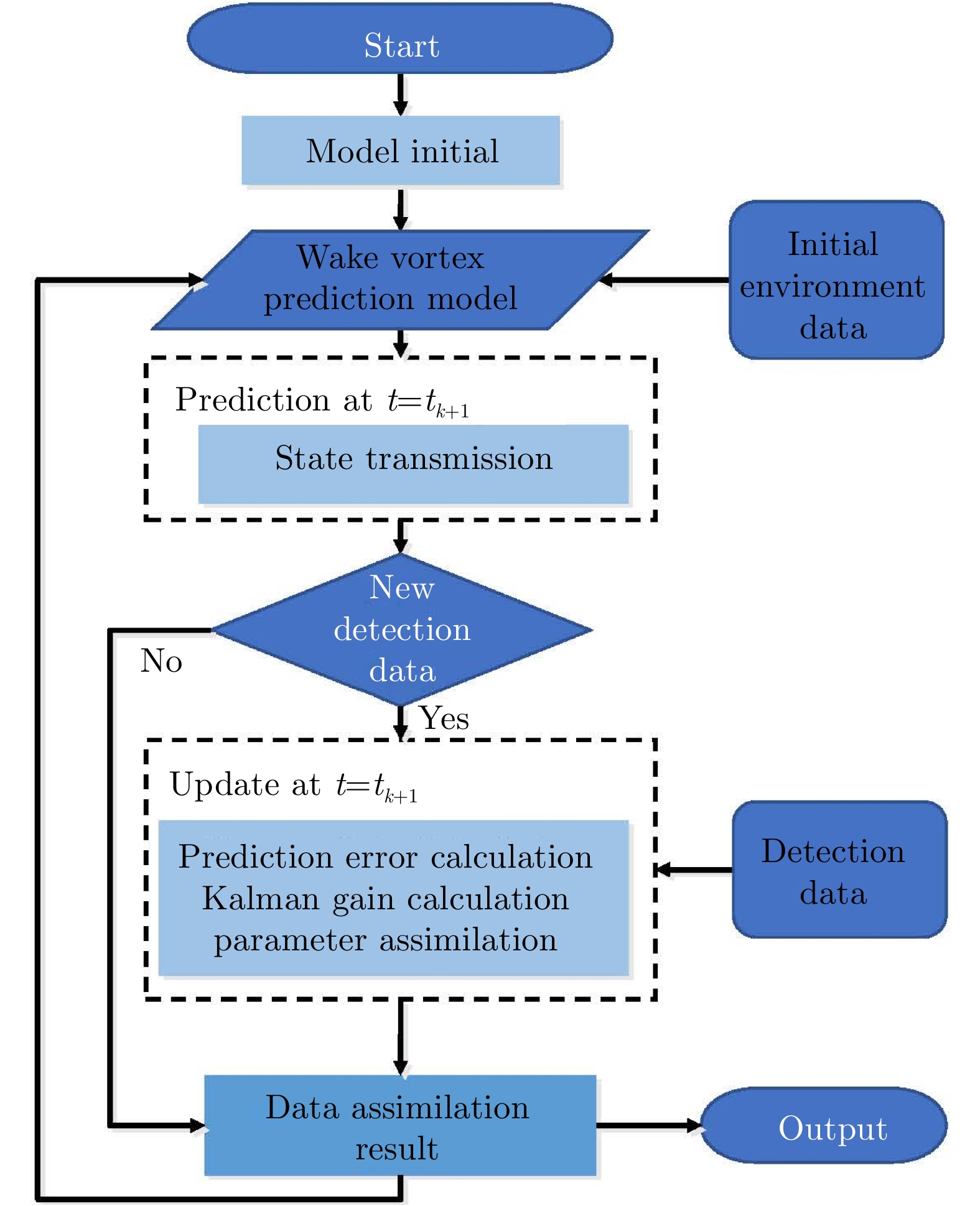
摘要: 飞机尾流是飞机飞行时在其后方产生的一对反向旋转的强烈湍流,对后续飞机飞行以及机场安全起降影响极大,其演化趋势的预测已成为空中交通安全管制的瓶颈,亟需发展基于实时探测数据的飞机尾流行为预测技术。在雷达探测反演得到的尾流涡心位置和速度环量等特征参数基础上,开展飞机尾流行为预测分析,能够预知飞机尾流危害区域,为机场安全起降动态间隔标准制定提供技术支撑。该文结合风场线性切变和最小二乘拟合方法构建了参数化尾流行为预测模型,解决了经典尾流预测模型气象环境参数未随时间演化实时调整的问题。该文根据复杂风场非线性演化特点,设计了基于无迹卡尔曼滤波的数据同化模型,利用雷达探测数据对尾流行为预测进行实时修正。数值仿真验证和实测数据验证结果表明,基于数据同化的飞机尾流行为预测方法能够根据实时探测数据对尾流行为预测轨迹进行修正,得到更加贴近实测的飞机尾流行为预测轨迹。Abstract: Aircraft wake are a couple of counter-rotating vortices generated by a flying aircraft, which can pose a serious hazard to follower aircraft. The behavior prediction of it is a key issue for air traffic safety management. To this end, we propose a prediction method based on data assimilation, which can be used to predict the evolution and hazard area of aircraft wake vortex from the vortex-core’s positions and circulation. To construct our wake vortex prediction model, we use linear shear and least square estimation. In addition, we use a data assimilation model based on the unscented Kalman filter to instantly correct the predicted trajectories. Our experimental results show that the proposed method performs well and runs steadily, thus, providing an effective tool for aircraft wake vortex prediction and support for the establishment of dynamic wake separation in air traffic management.
-
Key words:
- Data assimilation /
- Aircraft wake vortex /
- Behavior prediction /
- Lidar detection
-

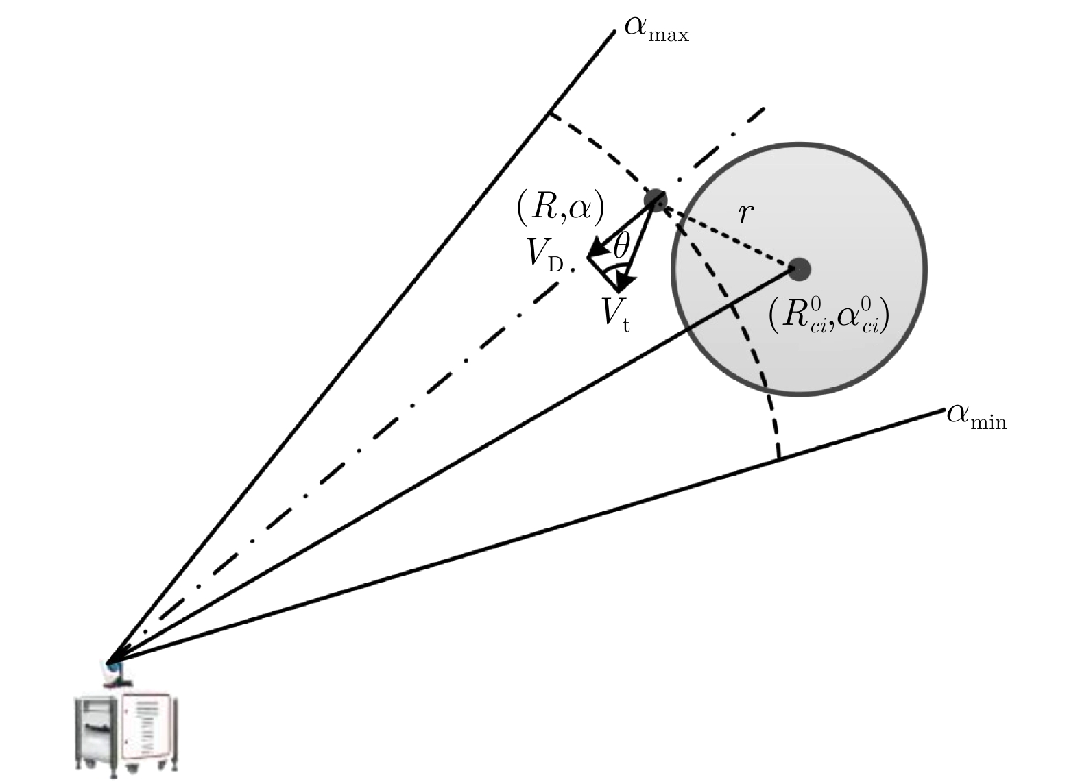
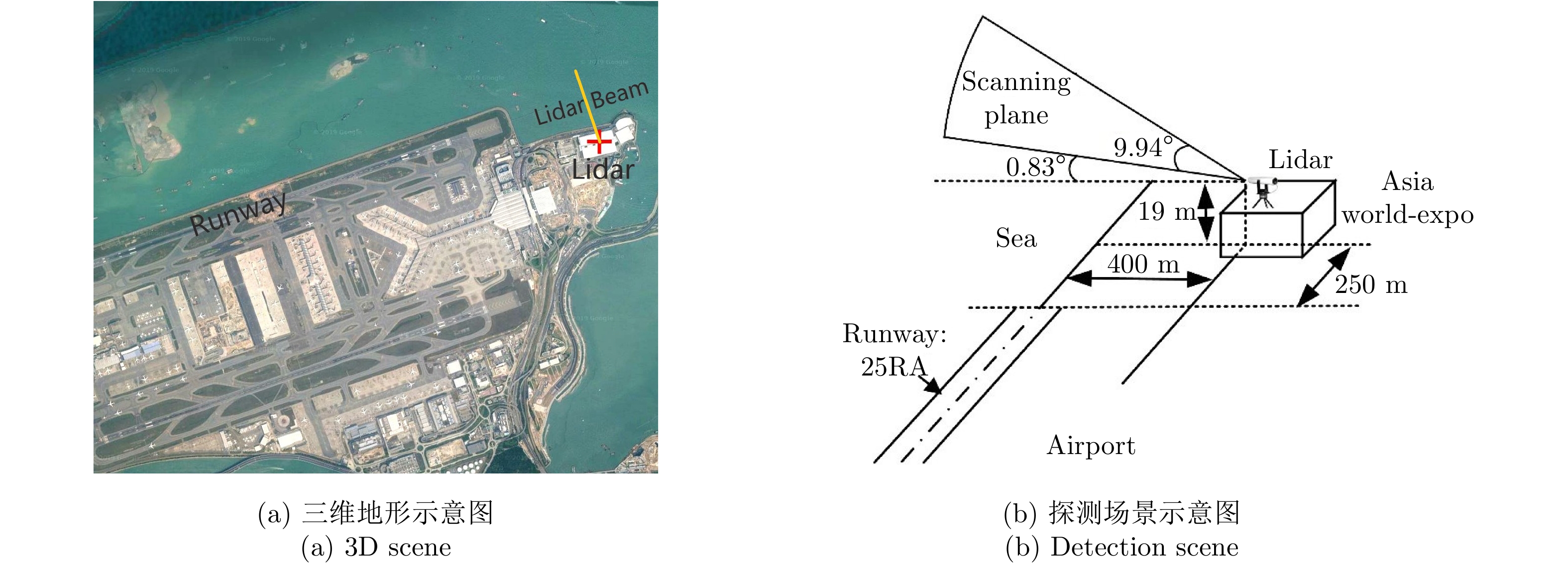
图 2 激光雷达探测飞机尾流场景设置
Figure 2. Geometry configuration for Lidar detection of wake vortex

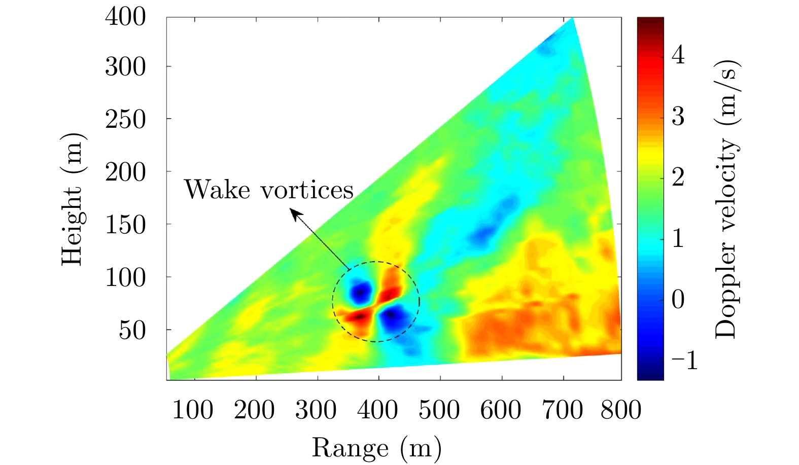
图 3 飞机尾流多普勒速度RHI回波分布图
Figure 3. Doppler velocity distribution of wake vortex in an RHI

图 5 估计背景风场的非尾流区域
Figure 5. Regions free of wake vortex that was used to estimate the background wind

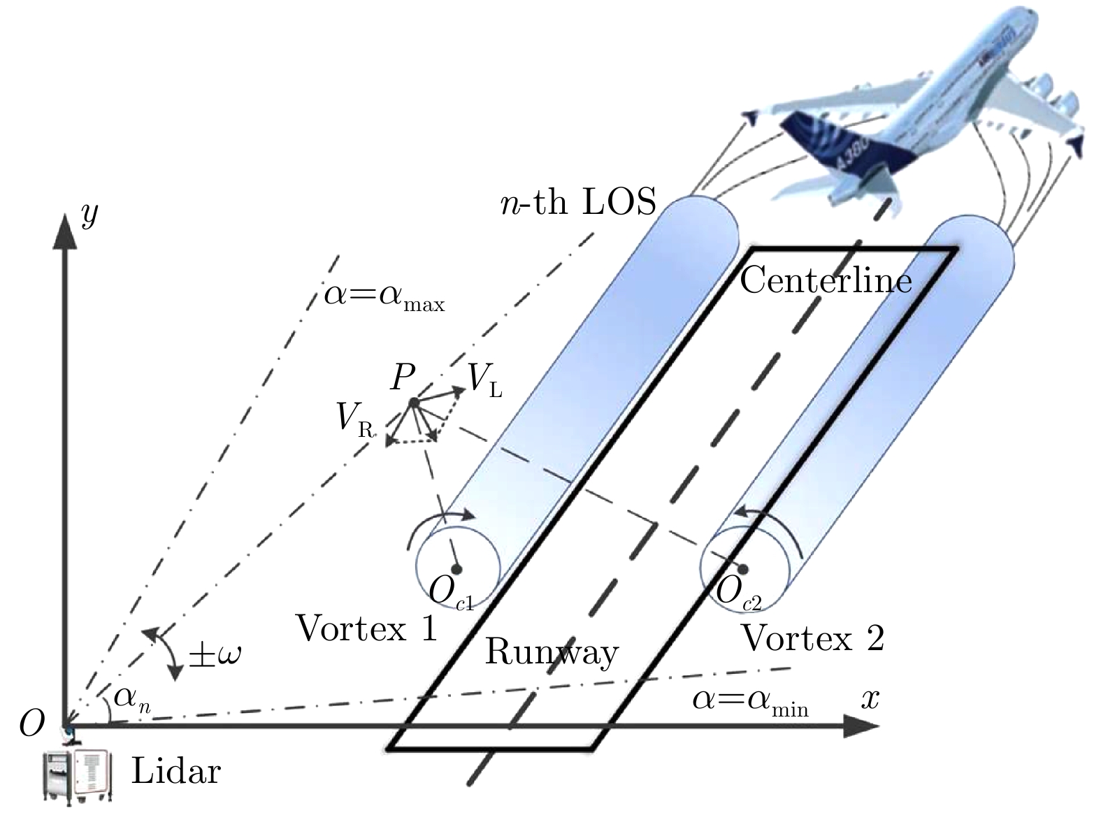
图 6 切向速度与多普勒速度的几何关系
Figure 6. Relationship between the tangential velocity and Doppler velocity
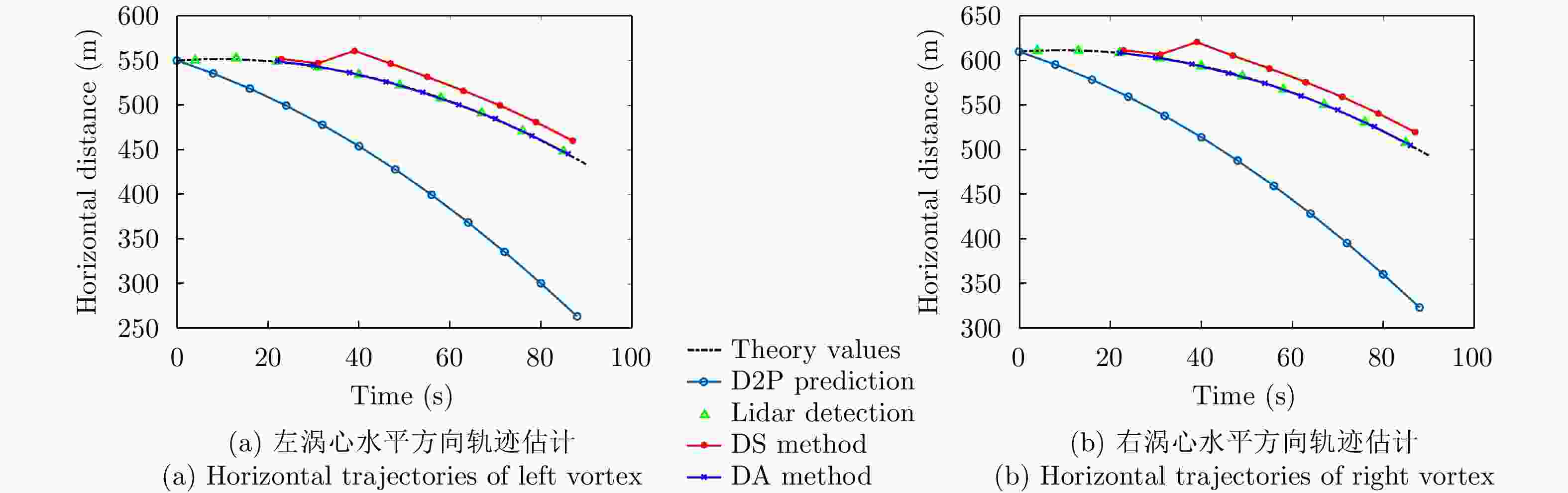
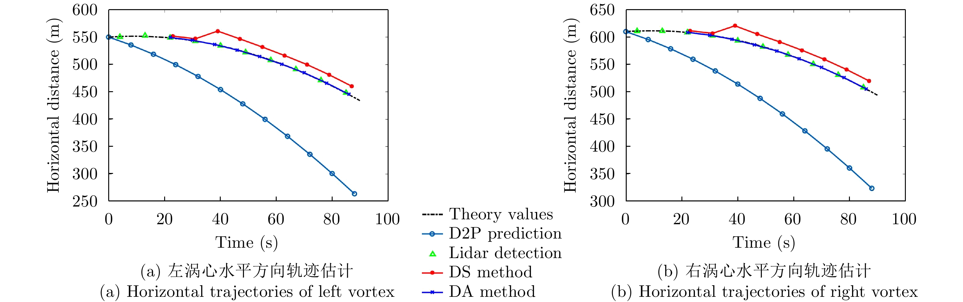
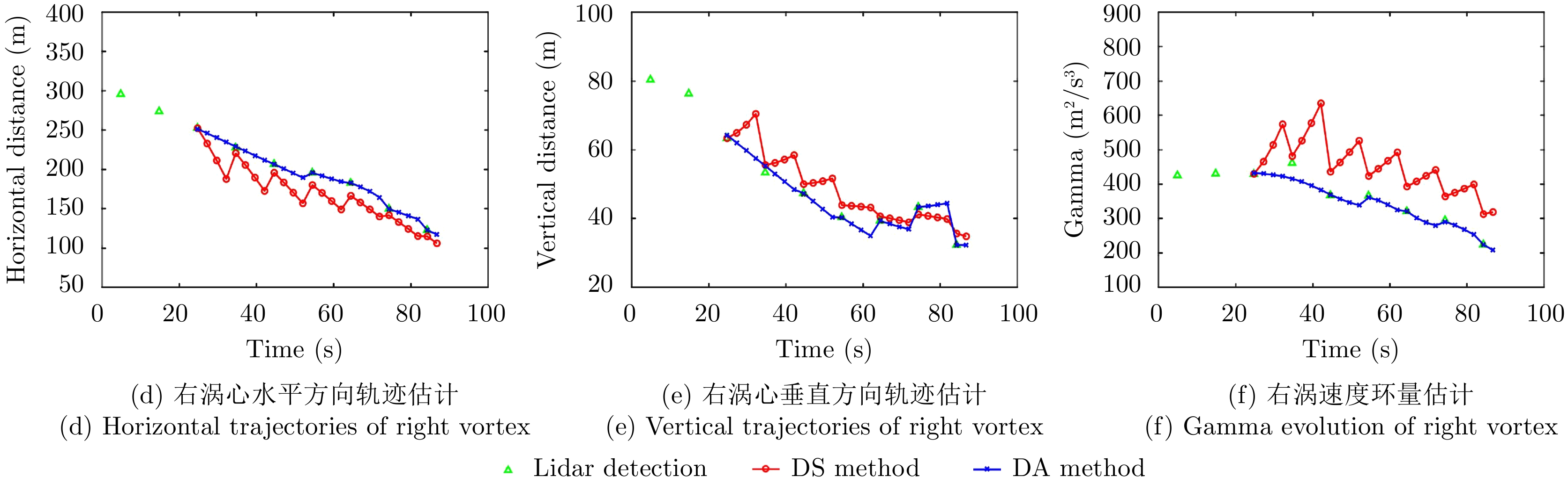
图 8 飞机尾流行为预测方法对比(水平方向轨迹)
Figure 8. Comparison between different wake vortex behavior prediction (Horizontal trajectories)
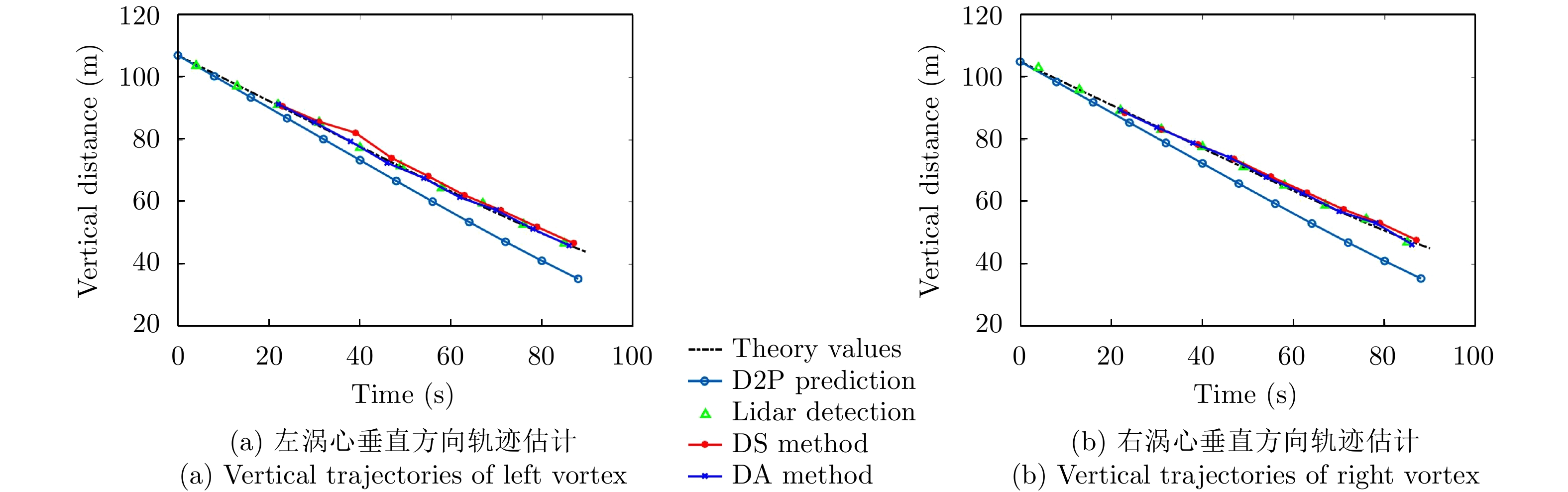
图 9 飞机尾流行为预测方法对比(垂直方向轨迹)
Figure 9. Comparison between different wake vortex behavior prediction (Vertical trajectories)

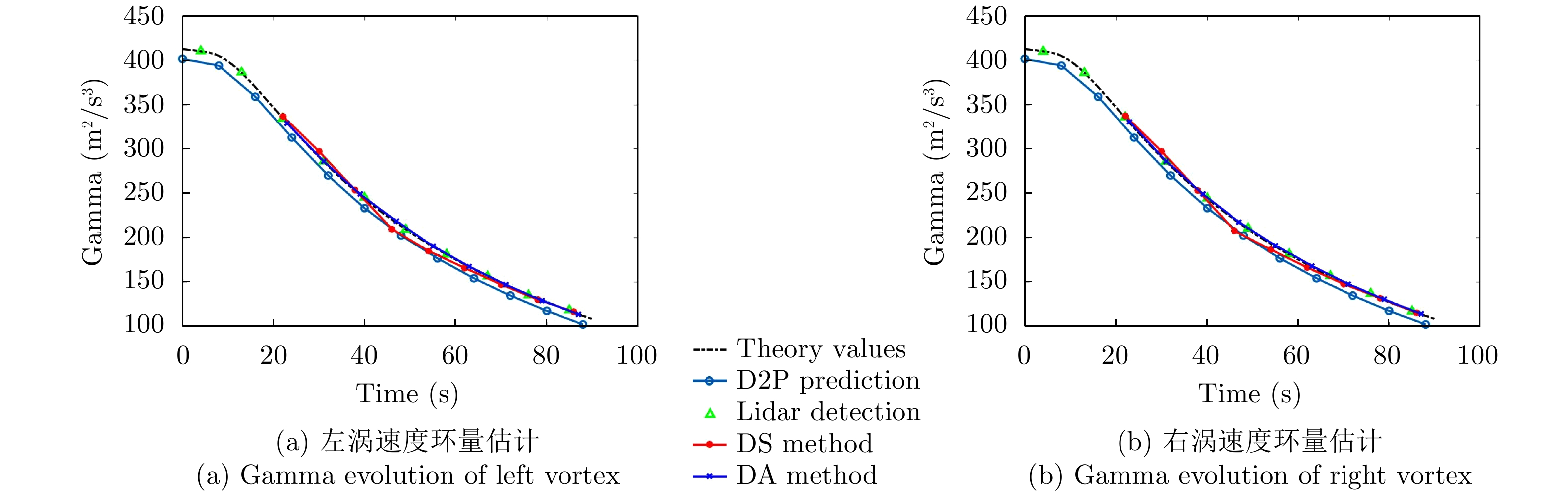
图 10 飞机尾流行为预测方法对比(速度环量)
Figure 10. Comparison between different wake vortex behavior prediction (Circulation)
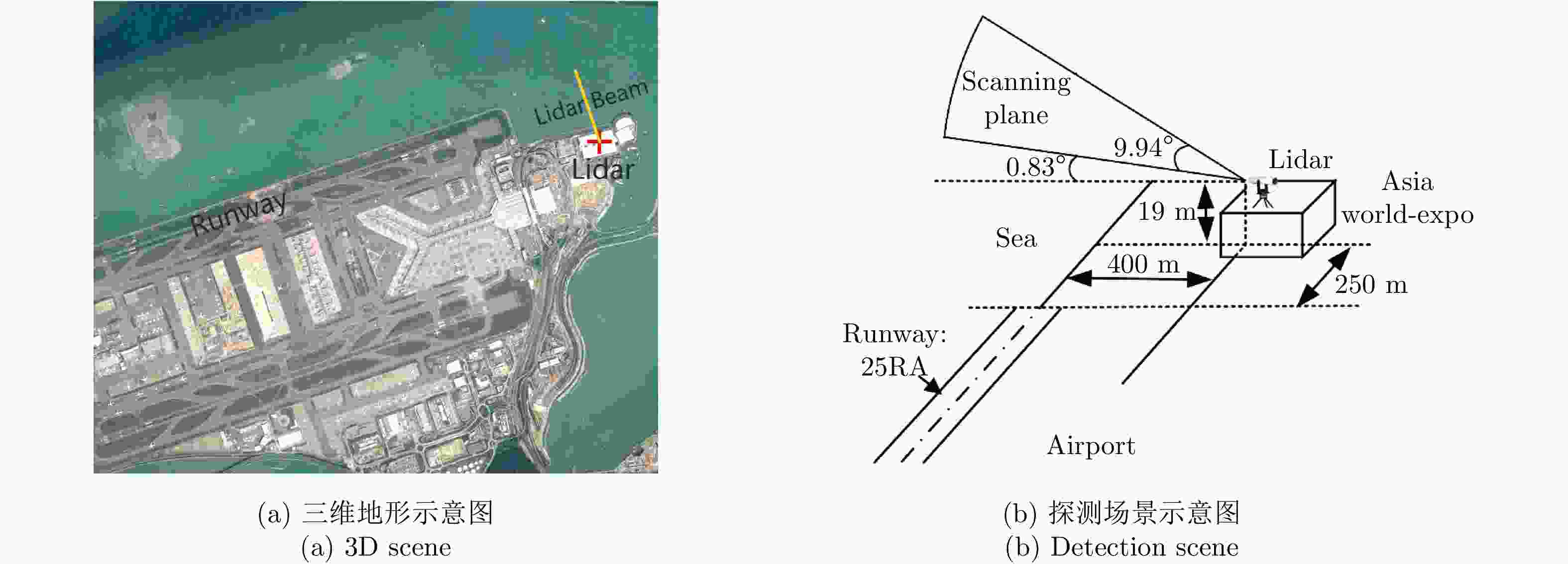
图 11 香港机场北跑道激光雷达探测场景设置2014
Figure 11. Geometry setup of the observation in north runway of Hong Kong international airport, 2014
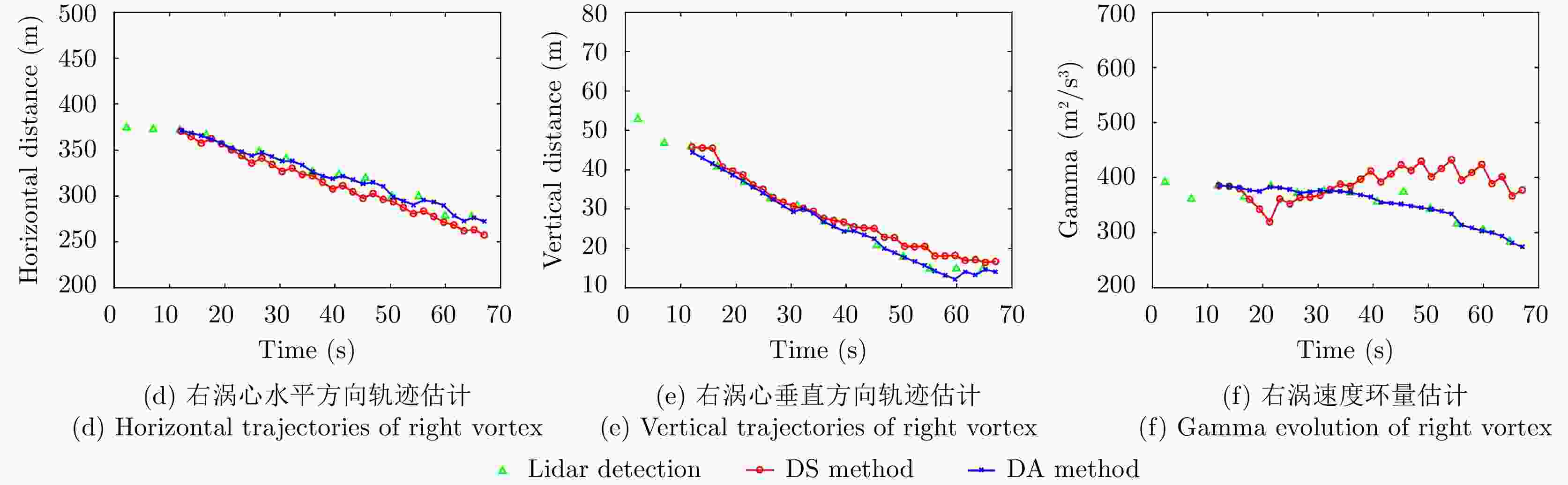
图 12 飞机尾流行为预测方法对比
Figure 12. Comparison between different wake vortex behavior prediction
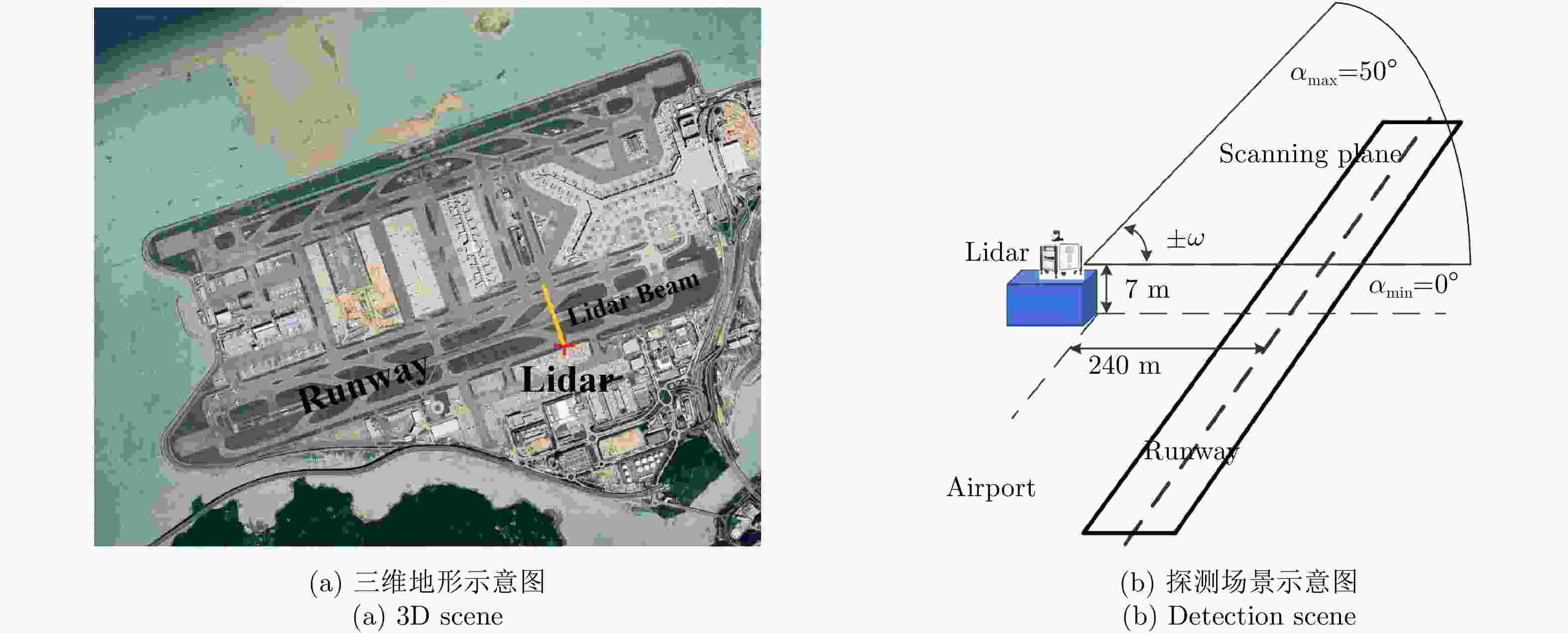
图 13 香港机场南跑道激光雷达探测场景设置2018
Figure 13. Geometry setup of the observation in south runway of Hong Kong international airport, 2018
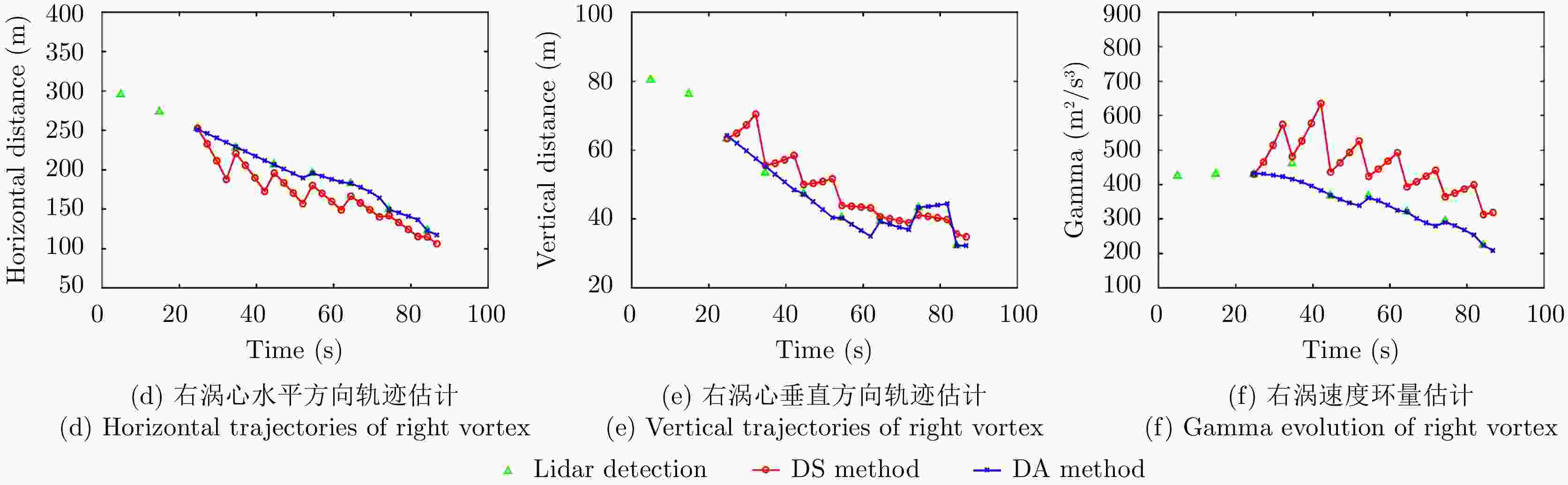
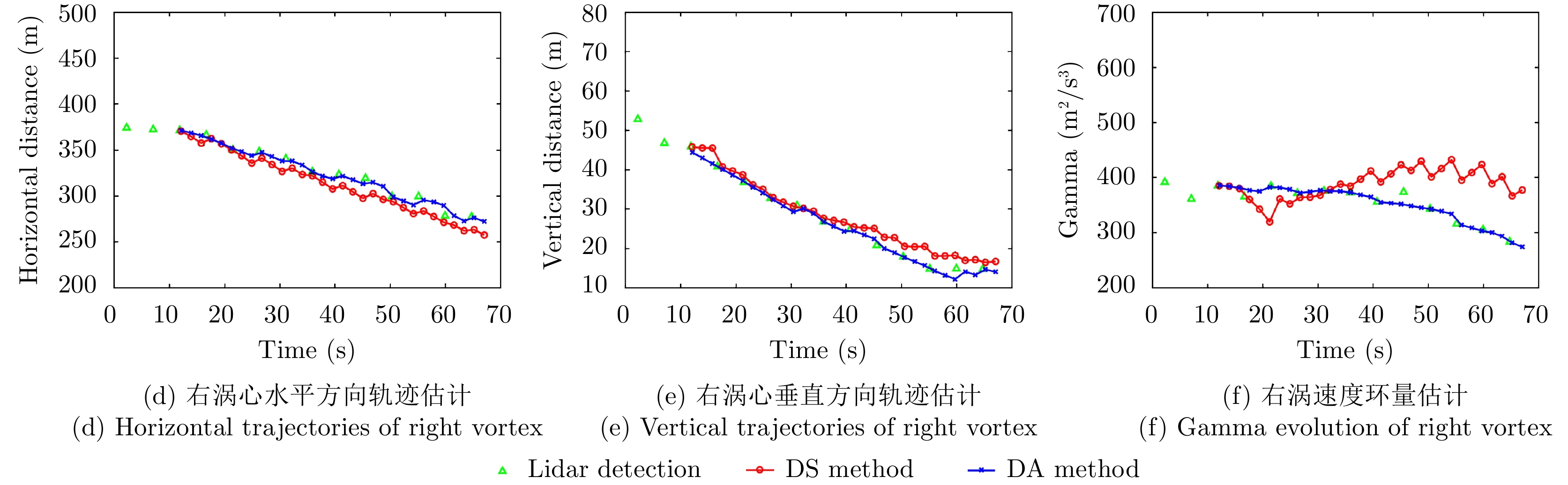
图 14 飞机尾流行为预测方法对比
Figure 14. Comparison between different wake vortex behavior prediction
表 1 激光雷达探测参数设置
Table 1. Detection parameters of the Lidar
主要参数 量值 雷达波长 1.55 μm 脉冲宽度 170 ns 时间窗长度 120 ns 距离门宽度 21 m 采样率 50 MHz 脉冲积累数 1500 信号噪声比 –5 dB 扫描速度 2°/s 扫描范围 0~15°  下载: 导出CSV
表 2 飞机尾流预测位置相对误差
Table 2. Relative error of predict trajectories
主要参数 DS method (%) DA method (%) 横向风
$V_{\rm{c}}^0$ (${\rm{m/s}}$)切变率$\beta $ 纵向风
$V_{\rm{c}}^{\rm{y}}$ (${\rm{m/s}}$)${E_{r1}}$ ${E_{r2}}$ ${E_{r1}}$ ${E_{r2}}$ –7 0.05 –0.3 17.74 19.63 1.12 1.35 –10 0.05 –0.3 26.83 28.52 2.64 2.41 –5 0.01 –0.3 3.42 3.14 1.98 1.76 –5 0.10 –0.3 4.16 4.71 2.86 2.17 –5 0.05 -0.5 3.59 3.21 1.23 1.01 –5 0.05 –0.8 6.87 6.52 1.36 1.71
下载: 导出CSV
表 3 飞机尾流速度环量相对误差
Table 3. Relative error of wake vortex circulation
主要参数
EDR (${{\rm{m}}^2}/{{\rm{s}}^3}$)DS method (%) DA method (%) ${E_{r1}}$ ${E_{r2}}$ ${E_{r1}}$ ${E_{r2}}$ 0.01 3.24 3.58 1.12 1.31 0.03 3.26 3.75 1.25 1.02 0.08 3.04 2.95 1.17 1.16 0.10 3.41 3.25 1.08 1.29
下载: 导出CSV
表 4 香港机场激光雷达探测参数设置
Table 4. Detection parameters of the Lidar in Hong Kong field campaigns
主要参数 量值 雷达波长(μm) 1.54 距离门宽度(m) 25 脉冲宽度(ns) 200 脉冲重复频率(kHz) 20 探测距离(m) 50~6000
下载: 导出CSV
-
[1] 李健兵, 高航, 王涛, 等. 飞机尾流的散射特性与探测技术综述[J]. 雷达学报, 2017, 6(6): 660–672. doi: 10.12000/JR17068LI Jianbing, GAO Hang, WANG Tao, et al. A survey of the scattering characteristics and detection of aircraft wake vortices[J]. Journal of Radars, 2017, 6(6): 660–672. doi: 10.12000/JR17068 [2] GERZ T, HOLZÄPFEL F, BRYANT W, et al. Research towards a wake-vortex advisory system for optimal aircraft spacing[J]. Comptes Rendus Physique, 2005, 6(4/5): 501–523. doi: 10.1016/j.crhy.2005.06.002 [3] THOBOIS Ludovic and CARIOU Jean-Pierre. Next generation scanning LIDAR systems for optimizing wake turbulence separation minima[J]. Journal of Radars, 2017, 6(6): 689–698. doi: 10.12000/JR17056. [4] HON Kaikwong and CHAN Pakwai. Aircraft wake fortex observations in Hong Kong[J]. Journal of Radars, 2017, 6(6): 709–718. doi: 10.12000/JR17072. [5] Vortex State-of-the-Art & Research Needs. Project report under EC contract 2134622015[R]. 2015. doi: 10.17874/BFAEB7154B0. [6] CHENG J, TITTSWORTH J, GALLO W, et al. The development of wake turbulence recategorization in the United States[C]. 8th AIAA Atmospheric and Space Environments Conference, Washington, USA, 2016: 1–12. [7] HOLZÄPFEL F. Probabilistic two-phase wake vortex decay and transport model[J]. Journal of Aircraft, 2003, 40(2): 323–331. doi: 10.2514/2.3096 [8] HOLZÄPFEL F. Sensitivity analysis of the effects of aircraft and environmental parameters on aircraft wake vortex trajectories and lifetimes[C]. 51st AIAA Aerospace Sciences Meeting including the New Horizons Forum and Aerospace Exposition, Dallas, USA, 2013: 7–10. [9] DE VISSCHER I, WINCKELMANS G, LONFILS T, et al. The WAKE4D simulation platform for predicting aircraft wake vortex transport and decay: Description and examples of application[C]. AIAA Atmospheric and Space Environments Conference, Toronto, Canada, 2010: 7994. [10] SARPKAYA T, ROBINS R E, and DELISI D P. Wake-vortex eddy-dissipation model predictions compared with observations[J]. Journal of Aircraft, 2001, 38(4): 687–692. doi: 10.2514/2.2820 [11] DELISI D P. Development of the VIPER fast-time wake vortex model (development, assumptions, examples, and plans)[C]. WakeNet3-Europe Specific Workshop on "Operational Wake Vortex Models", Belgium, 2011. [12] PROCTOR F, HAMILTON D, and SWITZER G. TASS driven algorithms for wake prediction[C]. 44th AIAA Aerospace Sciences Meeting and Exhibit, Reno, USA, 2006. [13] HOLZÄPFEL F. On the maturity of wake vortex observation, prediction, and validation[C]. WakeNet3-Eurooe 1st Workshop on "Wake Turbulence Safety in Future Aircraft Operations", Paris, France, 2009. [14] DE VISSCHER I, WINCKELMANS G, and BRICTEUX L. Some reflections on the achievable quality of operational WV prediction using operational meteorological and aircraft inputs[C]. WakeNet3-Europe 1st Workshop on "Wake Turbulence Safety in Future Aircraft Operations", Paris, France, 2009. [15] PRUIS M J. Development of a new probabilistic wake vortex prediction model[C]. WakeNet3-Europe Specific Workshop on "Operational Wake Vortex Models", Belgium, 2011. [16] SCHÖNHALS S, STEEN M, and HECKER P. Wake vortex prediction and detection utilising advanced fusion filter technologies[J]. The Aeronautical Journal, 2011, 115(1166): 221–228. doi: 10.1017/S0001924000005674 [17] LI Jianbing, CHAN P W, WANG Tao, et al. Circulation retrieval of wake vortex with a side-looking scanning Lidar[C]. CIE International Conference on Radar, Guangzhou, China, 2016: 1–4. [18] JULIER S, UHLMANN J, and DURRANT-WHYTE H F. A new method for the nonlinear transformation of means and covariances in filters and estimators[J]. IEEE Transactions on Automatic Control, 2000, 45(3): 477–482. doi: 10.1109/9.847726 [19] JULIER S J and UHLMANN J K. Unscented filtering and nonlinear estimation[J]. Proceedings of the IEEE, 2004, 92(3): 401–422. doi: 10.1109/JPROC.2003.823141 [20] GERZ T, HOLZÄPFEL F, and DARRACQ D. Commercial aircraft wake vortices[J]. Progress in Aerospace Sciences, 2002, 38(3): 181–208. doi: 10.1016/S0376-0421(02)00004-0 [21] 屈龙海. 晴空和湿性大气中飞机尾流雷达散射特性的研究[D]. [博士论文], 国防科技大学, 2015: 29–31.QU Longhai. Study on the radar scattering characteristics of aircraft wake vortex in clear air and moist air[D]. [Ph. D. dissertation], National University of Defense Technology, 2015: 29–31. [22] AHMAD N N and PROCTOR F. Review of idealized aircraft wake vortex models[C]. 52nd Aerospace Sciences Meeting, National Harbor, USA, 2014. [23] BURNHAM D. Chicago monostatic acoustic vortex sensing system, Volume I: Data collection and reduction[R]. FAA-RD-79-103, 1979. [24] SHEN Chun, LI Jianbing, ZHANG Fulin, et al. Two-step locating method for aircraft wake vortices based on Gabor filter and velocity range distribution[J]. IET Radar, Sonar & Navigation, 2020, 14(12): 1958–1967. doi: 10.1049/iet-rsn.2020.0319 [25] LI Jianbing, SHEN Chun, GAO Hang, et al. Path Integration (PI) method for the parameter-retrieval of aircraft wake vortex by Lidar[J]. Optics Express, 2020, 28(3): 4286–4306. doi: 10.1364/OE.382968 [26] 焦云涛. 低空风切变与飞行安全[J]. 民航经济与技术, 1994, (11): 13–14.JIAO Yuntao. Windshear at low altitude and flight safety[J]. Civil Aviation Economics and Technology, 1994, (11): 13–14. [27] WILSON D K, OSTASHEV V E, GOEDECKE G H, et al. Quasi-wavelet calculations of sound scattering behind barriers[J]. Applied Acoustics, 2004, 65(6): 605–627. doi: 10.1016/j.apacoust.2003.11.009 [28] 张宏昇. 大气湍流基础[M]. 北京: 北京大学出版社, 2014: 161–165.ZHANG Hongsheng. Atmospheric Turbulence Foundation[M]. Beijing: Peking University Press, 2014: 161–165. [29] 李金梁. 箔条干扰的特性与雷达抗箔条技术研究[D]. [博士论文], 国防科学技术大学, 2010: 57–58.LI Jinliang. Study on characteristics of chaff jamming and anti-chaff technology for radar[D]. [Ph.D. dissertation], National University of Defense Technology, 2010: 57–58. [30] SMALIKHO I N, BANAKH V A, HOLZÄPFEL F, et al. Method of radial velocities for the estimation of aircraft wake vortex parameters from data measured by coherent Doppler Lidar[J]. Optics Express, 2015, 23(19): A1194–A1207. doi: 10.1364/OE.23.0A1194 [31] 沈淳, 高航, 王雪松, 等. 基于激光雷达探测的飞机尾流特征参数反演系统[J]. 雷达学报, 2020, 9(6): 1032–1044. doi: 10.12000/JR20046SHEN Chun, GAO Hang, WANG Xuesong, et al. Aircraft wake vortex parameter-retrieval system based on Lidar[J]. Journal of Radars, 2020, 9(6): 1032–1044. doi: 10.12000/JR20046 [32] GAO Hang, LI Jianbing, CHAN P W, et al. Parameter-retrieval of dry-air wake vortices with a scanning Doppler Lidar[J]. Optics Express, 2018, 26(13): 16377–16392. doi: 10.1364/OE.26.016377 -


计量
- 文章访问数:
- HTML全文浏览量:
- PDF下载量:
- 被引次数: 0

