
 作者中心
作者中心 专家审稿
专家审稿 责编办公
责编办公 编辑办公
编辑办公
Application of Spaceborne Interferometric Synthetic Aperture Radar to Geohazard Monitoring
-
摘要: 近年来,星载InSAR技术在地质灾害监测领域显示出越来越大的应用潜力。该文首先介绍了InSAR形变监测的原理;然后系统性回顾了InSAR技术的发展,分析了差分InSAR、时序InSAR等方法的技术特点和适用范围;进而从地质灾害监测应用的角度分析了InSAR技术在地震、滑坡、水利工程、地面沉降等领域的应用现状和发展趋势;最后总结了当前地灾监测应用中InSAR技术在大气效应校正、复杂地区形变信息获取、多维形变信息获取中的关键问题,以期服务于地质灾害动态监测与防治工作。从当前InSAR技术在地质灾害监测的应用来看,该技术正处在广泛的业务应用阶段,随着未来星载SAR卫星系统的发展和行业的驱动,必将发展成为一项成熟的高精度对地观测技术,对地质灾害监测产生巨大的影响。Abstract: In recent years, spaceborne Interferometric Synthetic Aperture Radar (InSAR) technology has shown increasing application potential in the field of geohazard monitoring. In this article, we first introduce the principle of InSAR technology, then systematically review the development of InSAR technology and analyze the technical characteristics and applicable scope of methods such as differential InSAR and time-series InSAR. We then discuss the application status and development trend of InSAR technology in geohazard monitoring with respect to earthquakes, landslides, hydropower projects, and ground subsidence. Finally, to guide future work in the dynamic monitoring and prevention of geohazards, we summarize the key issues and scientific problems faced by the application of InSAR to geohazard monitoring, which include atmospheric correction, complex-area deformation data acquisition, and the acquisition of multidimensional deformation data. Judging from the current applications of geological hazard monitoring, this technology is now at the point of extensive application. With the development of future spaceborne SAR satellite systems and the driving force of industry application, InSAR technology will develop into a sophisticated high-precision ground observation technology that will have a huge impact on geological hazard monitoring.
-
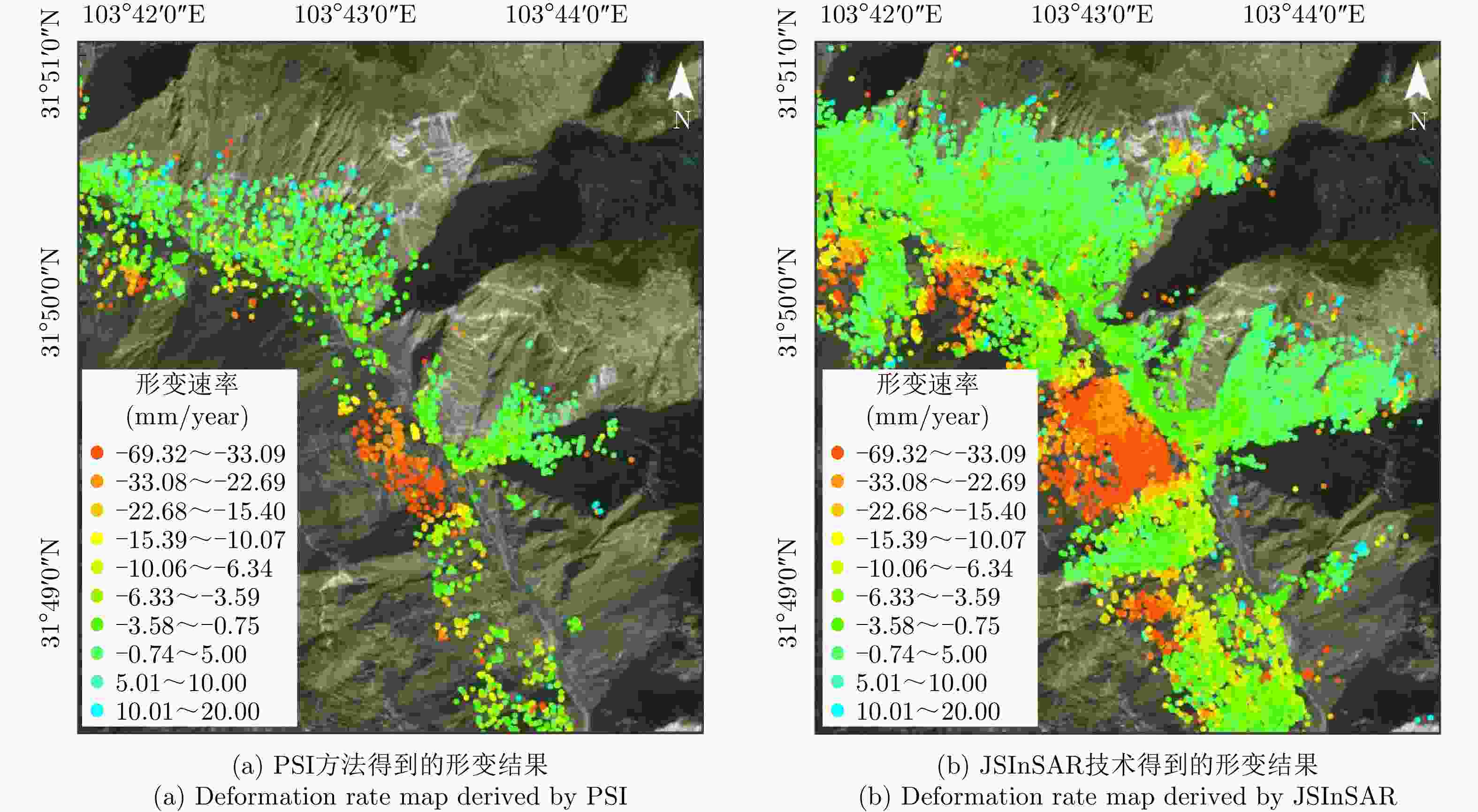
图 2 采用常规PSI技术和JSInSAR技术获得的四川地区某滑坡形变速率图
Figure 2. Deformation rate map of the landslide in Sichuan Province obtained by PSI and JSInSAR

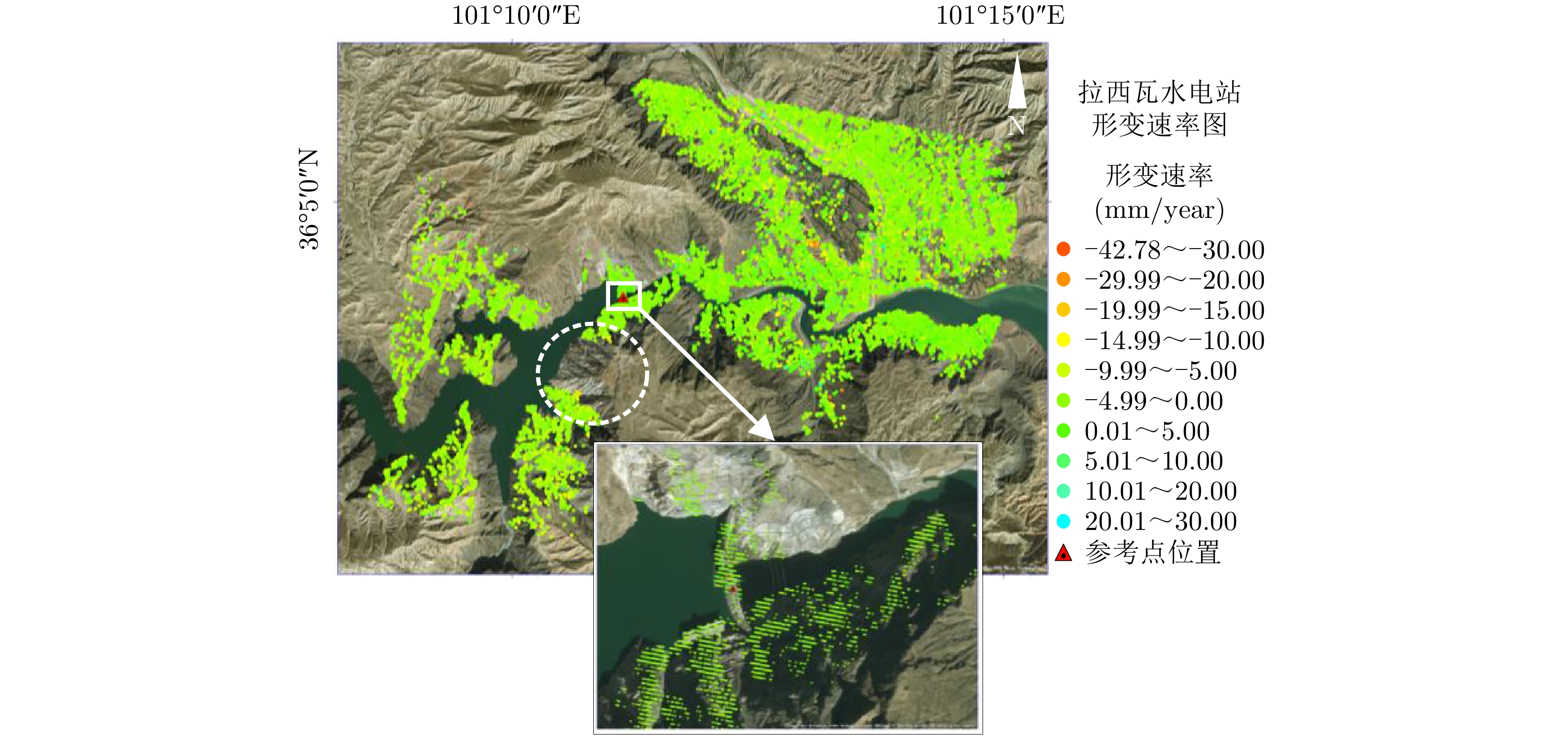
图 3 利用升轨数据获得的拉西瓦水电站周边形变速率图
Figure 3. Deformation map around the Laxiwa Hydropower Station obtained from the ascending orbit data
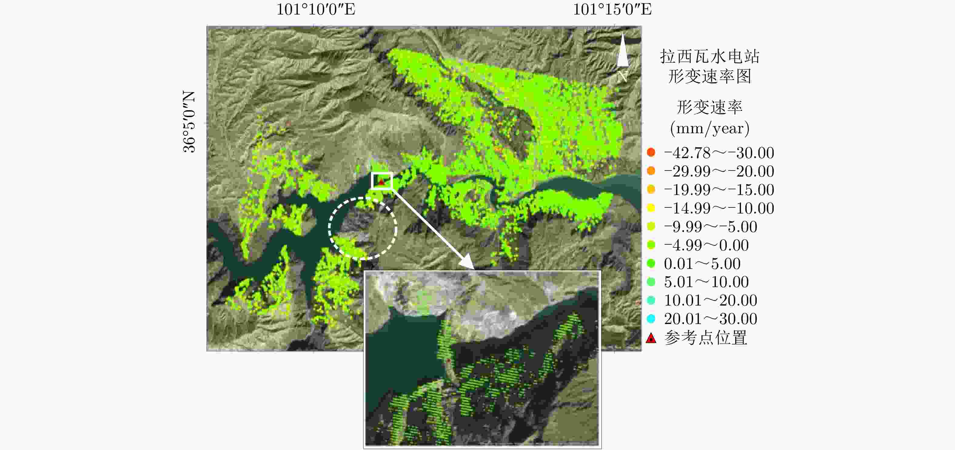
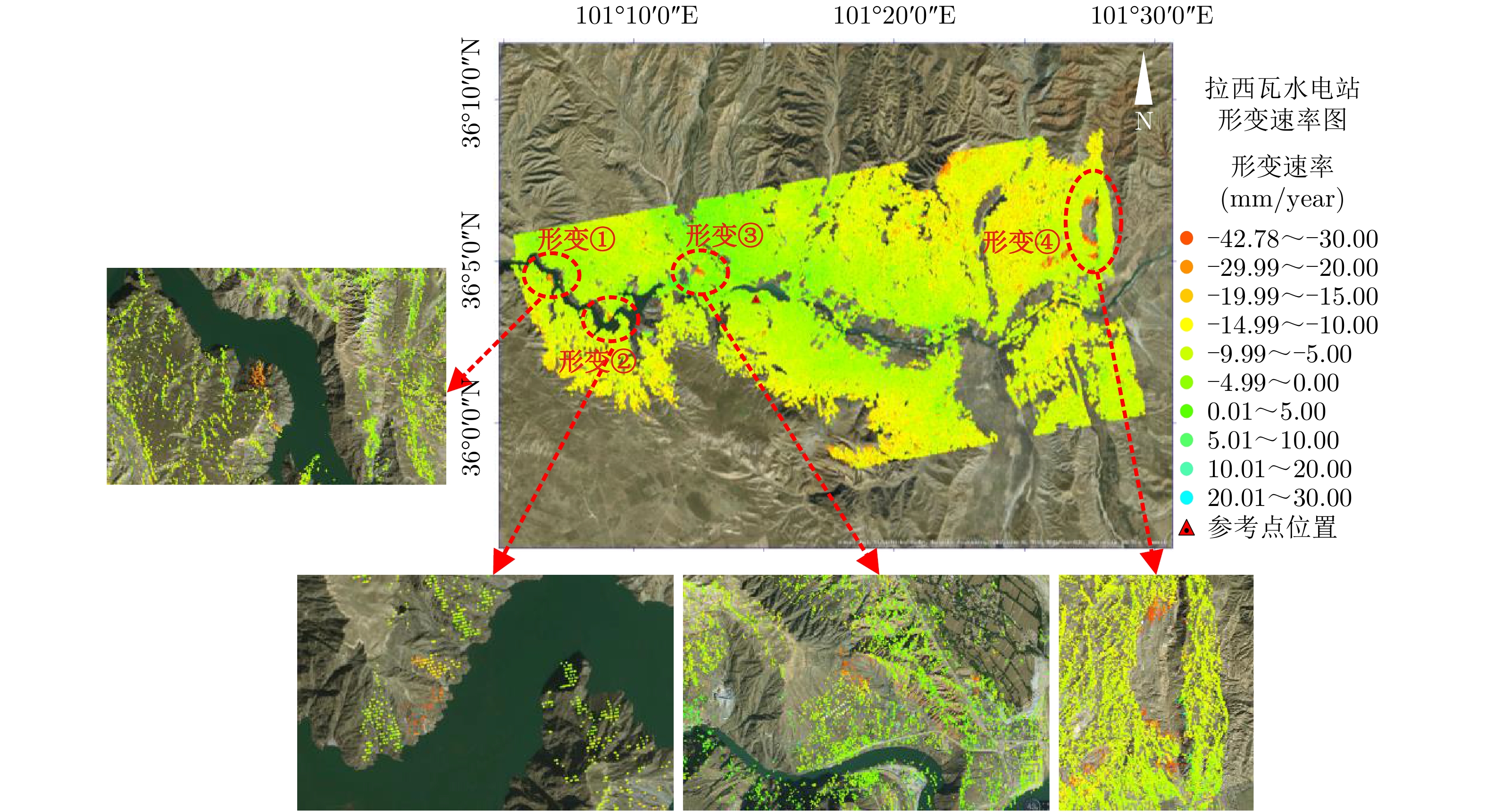
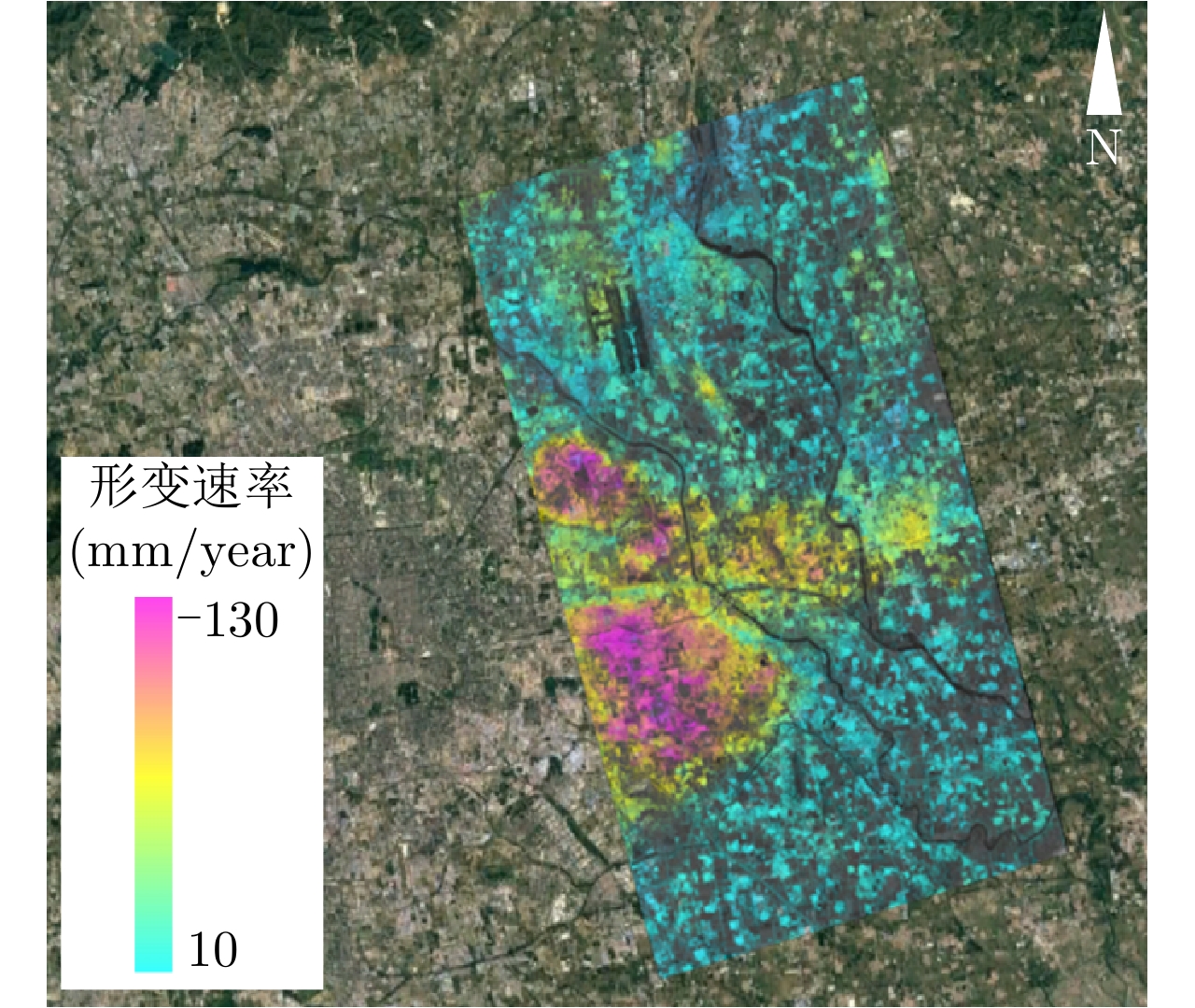
图 4 利用降轨数据获得的拉西瓦水电站坝体及周边形变速率图
Figure 4. Deformation map of the dam and surrounding area of the Laxiwa Hydropower Station obtained from the descending orbit data
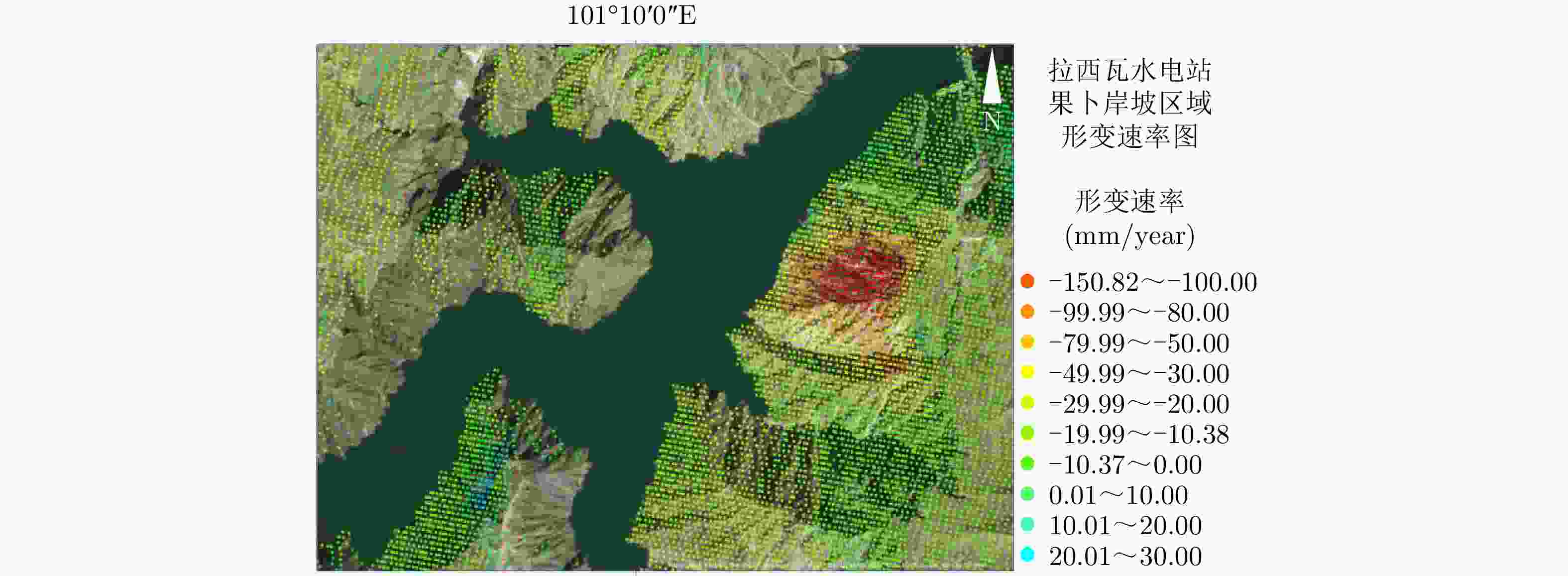
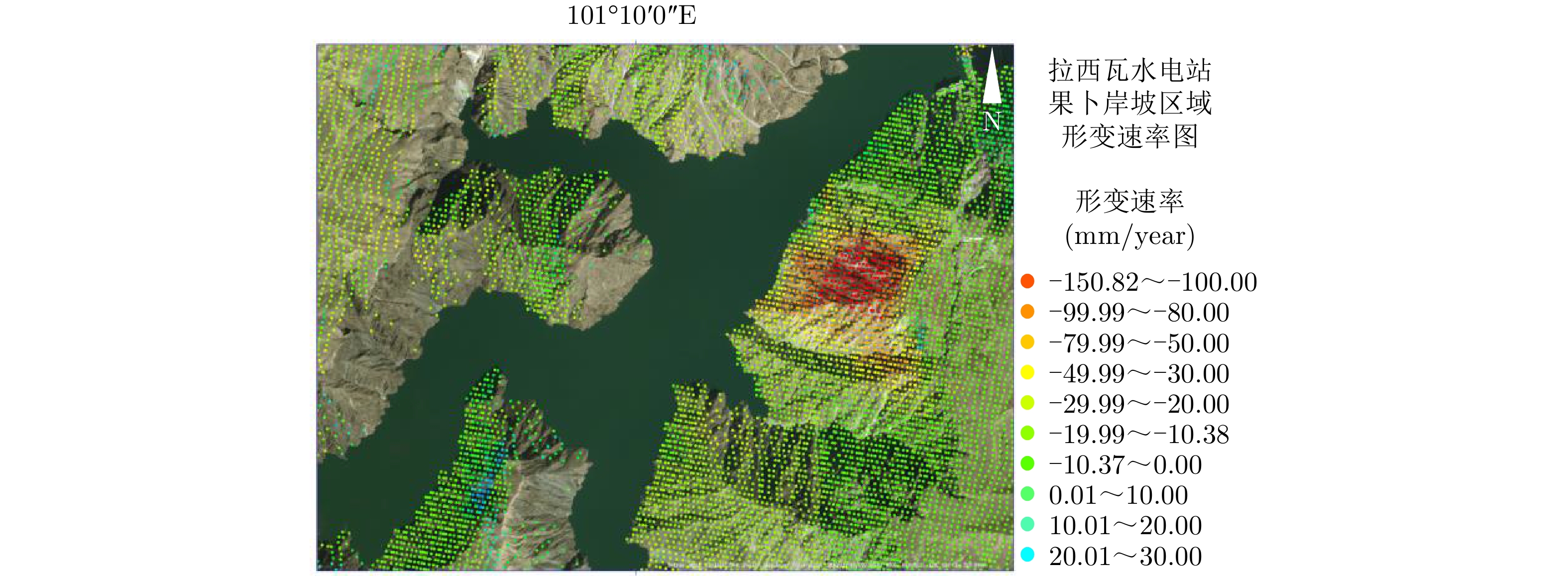
图 5 拉西瓦水电站果卜岸坡区域形变速率图
Figure 5. Deformation rate map of the Guobu slope of the Laxiwa Hydropower Station
-
[1] WILEY C A. Pulsed doppler radar methods and apparatus[P]. US, 3196436, 1965. [2] 廖明生, 林晖. 雷达干涉测量—原理与信号处理基础[M]. 北京: 测绘出版社, 2003: 32–35.LIAO Mingsheng and LIN Hui. Synthetic Aperture Radar Interferometry—Principle and Signal Processing[M]. Beijing: Surveying and Mapping Press, 2003: 32–35. [3] 秦小芳, 张华春, 张衡, 等. TerraSAR-X/TanDEM-X升降轨双基干涉模式获取DEM方法研究[J]. 雷达学报, 2018, 7(4): 487–497. doi: 10.12000/JR18022QIN Xiaofang, ZHANG Huachun, ZHANG Heng, et al. A high precision DEM generation method based on ascending and descending pass TerraSAR-X/TanDEM-X BiSAR data[J]. Journal of Radars, 2018, 7(4): 487–497. doi: 10.12000/JR18022 [4] HANSSEN R F. Radar Interferometry: Data Interpretation and Error Analysis[M]. New York: Springer, 2001: 15–16. [5] FERRETTI A, PRATI C, and ROCCA F. Permanent scatterers in SAR interferometry[J]. IEEE Transactions on Geoscience and Remote Sensing, 2001, 39(1): 8–20. doi: 10.1109/36.898661 [6] STROZZI T, ANTONOVA S, GÜNTHER F, et al. Sentinel-1 SAR interferometry for surface deformation monitoring in low-land permafrost areas[J]. Remote Sensing, 2018, 10(9): 1360. doi: 10.3390/rs10091360 [7] CARLÀ T, INTRIERI E, RASPINI F, et al. Perspectives on the prediction of catastrophic slope failures from satellite InSAR[J]. Scientific Reports, 2019, 9(1): 14137. doi: 10.1038/s41598-019-50792-y [8] GRANDIN R, VALLÉE M, and LACASSIN R. Rupture process of the MW 5.8 Pawnee, Oklahoma, earthquake from Sentinel‐1 InSAR and seismological data[J]. Seismological Research Letters, 2017, 88(4): 994–1004. doi: 10.1785/0220160226 [9] LEE S and LEE C W. Analysis of the relationship between volcanic eruption and surface deformation in volcanoes of the Alaskan Aleutian Islands using SAR interferometry[J]. Geosciences Journal, 2018, 22(6): 1069–1080. doi: 10.1007/s12303-018-0050-z [10] GOLDSTEIN R M, ENGELHARDT H, KAMB B, et al. Satellite radar interferometry for monitoring ice sheet motion: Application to an Antarctic ice stream[J]. Science, 1993, 262(5139): 1525–1530. doi: 10.1126/science.262.5139.1525 [11] 刘国祥, 陈强, 罗小军, 等. 永久散射体雷达干涉理论与方法[M]. 北京: 科学出版社, 2012: 23–36.LIU Guoxiang, CHEN Qiang, LUO Xiaojun, et al. Permanent Scatterer Radar Interference Theory and Method[M]. Beijing: Science Press, 2012: 23–36. [12] 陈富龙, 林珲, 程世来. 星载雷达干涉测量及时间序列分析的原理、方法与应用[M]. 北京: 科学出版社, 2013: 22–23, 53–56.CHEN Fulong, LIN Hui, and CHENG Shilai. Principles, Methods and Applications of Spaceborne Radar Interferometry and Time Series Analysis[M]. Beijing: Science Press, 2013: 22–23, 53–56. [13] COSTANTINI M, FALCO S, MALVAROSA F, et al. A new method for identification and analysis of persistent scatterers in series of SAR images[C]. 2008 IEEE International Geoscience and Remote Sensing Symposium, Boston, USA, 2008. doi: 10.1109/IGARSS.2008.4779025. [14] WERNER C, WEGMULLER U, STROZZI T, et al. Interferometric point target analysis for deformation mapping[C]. 2003 IEEE International Geoscience and Remote Sensing Symposium, Toulouse, France, 2003. doi: 10.1109/IGARSS.2003.1295516. [15] FERRETTI A, FUMAGALLI A, NOVALI F, et al. A new algorithm for processing interferometric data-stacks: SqueeSAR[J]. IEEE Transactions on Geoscience and Remote Sensing, 2011, 49(9): 3460–3470. doi: 10.1109/TGRS.2011.2124465 [16] LÜ Xiaolei, YAZICI B, ZEGHAL M, et al. Joint-Scatterer processing for time-series InSAR[J]. IEEE Transactions on Geoscience and Remote Sensing, 2014, 52(11): 7205–7221. doi: 10.1109/TGRS.2014.2309346 [17] HOOPER A, ZEBKER H, SEGALL P, et al. A new method for measuring deformation on volcanoes and other natural terrains using InSAR persistent scatterers[J]. Geophysical Research Letters, 2004, 31(23): L23611. doi: 10.1029/2004GL021737 [18] KAMPES B and ADAM N. The STUN algorithm for persistent scatterer interferometry[C]. Fringe 2005 Workshop, Frascati, Italy, 2005: 16. [19] BERARDINO P, FORNARO G, LANARI R, et al. A new algorithm for surface deformation monitoring based on small baseline differential SAR interferograms[J]. IEEE Transactions on Geoscience and Remote Sensing, 2002, 40(11): 2375–2383. doi: 10.1109/TGRS.2002.803792 [20] BLANCO-SÀNCHEZ P, MALLORQUÍ J J, DUQUE S, et al. The Coherent Pixels Technique (CPT): An advanced DInSAR technique for nonlinear deformation monitoring[J]. Pure and Applied Geophysics, 2008, 165(6): 1167–1193. doi: 10.1007/s00024-008-0352-6 [21] CROSETTO M, BIESCAS E, DURO J, et al. Generation of advanced ERS and Envisat interferometric SAR products using the stable point network technique[J]. Photogrammetric Engineering & Remote Sensing, 2008, 74(4): 443–450. doi: 10.14358/PERS.74.4.443 [22] FERRETTI A, PRATI C, and ROCCA F. Nonlinear subsidence rate estimation using permanent scatterers in differential SAR interferometry[J]. IEEE Transactions on Geoscience and Remote Sensing, 2000, 38(5): 2202–2212. doi: 10.1109/36.868878 [23] PARIZZI A and BRCIC R. Adaptive InSAR stack multilooking exploiting amplitude statistics: A comparison between different techniques and practical results[J]. IEEE Geoscience and Remote Sensing Letters, 2011, 8(3): 441–445. doi: 10.1109/LGRS.2010.2083631 [24] MICHEL R, AVOUAC J P, and TABOURY J. Measuring ground displacements from SAR amplitude images: Application to the Landers earthquake[J]. Geophysical Research Letters, 1999, 26(7): 875–878. doi: 10.1029/1999GL900138 [25] 廖明生, 张路, 史绪国, 等. 滑坡变形雷达遥感监测方法与实践[M]. 北京: 科学出版社, 2017: 103–134.LIAO Mingsheng, ZHANG Lu, SHI Xuguo, et al. Landslide Deformation Radar Remote Sensing Monitoring Method and Practice[M]. Beijing: Science Press, 2017: 103–134. [26] SIMONS M and ROSEN P A. 3.12-Interferometric synthetic aperture radar geodesy[J]. Treatise on Geophysics (Second Edition) , 2015, 3: 339–385. [27] STROZZI T, LUCKMAN A, MURRAY T, et al. Glacier motion estimation using SAR offset-tracking procedures[J]. IEEE Transactions on Geoscience and Remote Sensing, 2002, 40(11): 2384–2391. doi: 10.1109/TGRS.2002.805079 [28] SANDWELL D T and PRICE E J. Phase gradient approach to stacking interferograms[J]. Journal of Geophysical Research: Solid Earth, 1998, 103(B12): 30183–30204. doi: 10.1029/1998JB900008 [29] MASSONNET D, ROSSI M, CARMONA C, et al. The displacement field of the Landers earthquake mapped by radar interferometry[J]. Nature, 1993, 364(6433): 138–142. doi: 10.1038/364138a0 [30] REID H F. The mechanics of the earthquake, the California earthquake of April 18, 1906[R]. 1910. [31] BONCORI J P M. Measuring coseismic deformation with spaceborne synthetic aperture radar: A Review[J]. Frontiers in Earth Science, 2019, 7: 16. doi: 10.3389/feart.2019.00016 [32] MASSONNET D, FEIGL K L, VADON H, et al. Coseismic deformation field of the M=6.7 Northridge, California earthquake of January 17, 1994 recorded by two radar satellites using interferometry[J]. Geophysical Research Letters, 1994, 23(9): 969–972. doi: 10.1029/96GL00729 [33] POLLITZ F F, WICKS C, and THATCHER W. Mantle flow beneath a continental strike-slip fault: Postseismic deformation after the 1999 Hector Mine earthquake[J]. Science, 2001, 293(5536): 1814–1818. doi: 10.1126/science.1061361 [34] FIELDING E J, TALEBIAN M, ROSEN P A, et al. Surface ruptures and building damage of the 2003 Bam, Iran, earthquake mapped by satellite synthetic aperture radar interferometric correlation[J]. Journal of Geophysical Research: Solid Earth, 2005, 110(B3): B03302. doi: 10.1029/2004JB003299 [35] SHEN Zhengkang, SUN Jianbao, ZHANG Peizhen, et al. Slip maxima at fault junctions and rupturing of barriers during the 2008 Wenchuan earthquake[J]. Nature Geoscience, 2009, 2(10): 718–724. doi: 10.1038/ngeo636 [36] 沈强, 乔学军, 王琪, 等. 中国玉树MW6.9地震InSAR地表形变特征分析[J]. 大地测量与地球动力学, 2010, 30(3): 5–9.SHEN Qiang, QIAO Xuejun, WANG Qi, et al. Characteristic analysis of coseismic deformation of Yushu MW6.9 earthquake from InSAR images[J]. Journal of Geodesy and Geodynamics, 2010, 30(3): 5–9. [37] 王永哲. 利用GPS和InSAR数据反演2011年日本东北MW6.9地震断层的同震滑动分布[J]. 地震学报, 2015, 37(5): 796–805. doi: 10.11939/jass.2015.05.008WANG Yongzhe. Coseismic slip distribution of the 2011 Tohoku MW6.9 earthquake inferred from GPS and InSAR data[J]. Acta Seismologica Sinica, 2015, 37(5): 796–805. doi: 10.11939/jass.2015.05.008 [38] 季灵运, 刘传金, 徐晶, 等. 九寨沟MS7.0地震的InSAR观测及发震构造分析[J]. 地球物理学报, 2017, 60(10): 4069–4082. doi: 10.6038/cjg20171032JI Lingyun, LIU Chuanjin, XU Jing, et al. InSAR observation and inversion of the seismogenic fault for the 2017 Jiuzhaigou MS7.0 earthquake in China[J]. Chinese Journal of Geophysics, 2017, 60(10): 4069–4082. doi: 10.6038/cjg20171032 [39] ATZORI S, ANTONIOLI A, TOLOMEI C, et al. InSAR full-resolution analysis of the 2017–2018 M> 6 earthquakes in Mexico[J]. Remote Sensing of Environment, 2019, 234: 111461. doi: 10.1016/j.rse.2019.111461 [40] GAUDREAU É, NISSEN E K, BERGMAN E A, et al. The August 2018 Kaktovik earthquakes: Active tectonics in northeastern Alaska revealed with InSAR and seismology[J]. Geophysical Research Letters, 2019, 46(24): 14412–14420. doi: 10.1029/2019GL085651 [41] CRUDEN D M. A simple definition of a landslide[J]. Bulletin of the International Association of Engineering Geology, 1991, 43(1): 27–29. doi: 10.1007/BF02590167 [42] FRUNEAU B, DELACOURT C, ACHACHE J, et al. Landslide monitoring in south of France with tandem data[C]. Proceedings of the 3rd ERS Symposium on Space at the Service of Our Environment, Florence, Italy, 1997. [43] XIA Ye, KAUFMANN H, GUO X F, et al. Landslide monitoring in the Three Gorges area using D-InSAR and corner reflectors[J]. Photogrammetric Engineering & Remote Sensing, 2004, 70(10): 1167–1172. doi: 10.14358/PERS.70.10.1167 [44] DAI Keren, XU Qiang, LI Zhenhong, et al. Post-disaster assessment of 2017 catastrophic Xinmo landslide (China) by spaceborne SAR interferometry[J]. Landslides, 2019, 16(6): 1189–1199. doi: 10.1007/s10346-019-01152-4 [45] WANG Guijie, WANG Yunlong, ZANG Xisheng, et al. Locating and monitoring of landslides based on small baseline subset interferometric synthetic aperture radar[J]. Journal of Applied Remote Sensing, 2019, 13(4): 044528. doi: 10.1117/1.JRS.13.044528 [46] LI Lingjing, YAO Xin, YAO Jiaming, et al. Analysis of deformation characteristics for a reservoir landslide before and after impoundment by multiple D-InSAR observations at Jinshajiang River, China[J]. Natural Hazards, 2019, 98(2): 719–733. doi: 10.1007/s11069-019-03726-w [47] XUE Feiyang and LÜ Xiaolei. Applying time series interferometric synthetic aperture radar and the unscented Kalman filter to predict deformations in Maoxian landslide[J]. Journal of Applied Remote Sensing, 2019, 13(1): 014509. doi: 10.1117/1.JRS.13.014509 [48] 许强, 董秀军, 李为乐. 基于天-空-地一体化的重大地质灾害隐患早期识别与监测预警[J]. 武汉大学学报: 信息科学版, 2019, 44(7): 957–966. doi: 10.13203/j.whugis20190088XU Qiang, DONG Xiujun, and LI Weile. Integrated space-air-ground early detection, monitoring and warning system for potential catastrophic geohazards[J]. Geomatics and Information Science of Wuhan University, 2019, 44(7): 957–966. doi: 10.13203/j.whugis20190088 [49] 肖儒雅, 何秀凤. 时序InSAR水库大坝形变监测应用研究[J]. 武汉大学学报: 信息科学版, 2019, 44(9): 1334–1341. doi: 10.13203/j.whugis20170327XIAO Ruya and HE Xiufeng. Deformation monitoring of reservoirs and dams using time-series InSAR[J]. Geomatics and Information Science of Wuhan University, 2019, 44(9): 1334–1341. doi: 10.13203/j.whugis20170327 [50] WANG Q Q, HUANG Q H, HE N, et al. Displacement monitoring of upper Atbara dam based on time series InSAR[J]. Survey Review, 2019. doi: 10.1080/00396265.2019.1643529 [51] LI Menghua, ZHANG Lu, SHI Xuguo, et al. Monitoring active motion of the Guobu landslide near the Laxiwa Hydropower Station in China by time-series point-like targets offset tracking[J]. Remote Sensing of Environment, 2019, 221: 80–93. doi: 10.1016/j.rse.2018.11.006 [52] MA Peifeng, WANG Weixi, ZHANG Bowen, et al. Remotely sensing large-and small-scale ground subsidence: A case study of the Guangdong–Hong Kong–Macao Greater Bay Area of China[J]. Remote Sensing of Environment, 2019, 232: 111282. doi: 10.1016/j.rse.2019.111282 [53] FAROLFI G, DEL SOLDATO M, BIANCHINI S, et al. A procedure to use GNSS data to calibrate satellite PSI data for the study of subsidence: An example from the north-western Adriatic coast (Italy)[J]. European Journal of Remote Sensing, 2019, 52(sup4): 54–63. doi: 10.1080/22797254.2019.1663710 [54] RATEB A and KUO C Y. Quantifying vertical deformation in the Tigris–Euphrates Basin due to the groundwater abstraction: Insights from GRACE and Sentinel-1 satellites[J]. Water, 2019, 11(8): 1658. doi: 10.3390/w11081658 [55] 胡程, 董锡超, 李元昊. 大气层效应对地球同步轨道SAR系统性能影响研究[J]. 雷达学报, 2018, 7(4): 412–424. doi: 10.12000/JR18032HU Cheng, DONG Xichao, and LI Yuanhao. Atmospheric effects on the performance of geosynchronous orbit SAR systems[J]. Journal of Radars, 2018, 7(4): 412–424. doi: 10.12000/JR18032 [56] 李亮, 洪峻, 明峰. 电离层对中高轨SAR影响机理研究[J]. 雷达学报, 2017, 6(6): 619–629. doi: 10.12000/JR17016LI Liang, HONG Jun, and MING Feng. Mechanism study of ionospheric effects on medium-earth-orbit SAR[J]. Journal of Radars, 2017, 6(6): 619–629. doi: 10.12000/JR17016 [57] 崔喜爱, 曾琪明, 童庆禧, 等. 重轨星载InSAR测量中的大气校正方法综述[J]. 遥感技术与应用, 2014, 29(1): 9–17. doi: 10.11873/j.issn.1004-0323.2014.1.0009CUI Xi’ai, ZENG Qiming, TONG Qingxi, et al. Overview of the atmospheric correction methods in repeat-pass InSAR measurements[J]. Remote Sensing Technology and Application, 2014, 29(1): 9–17. doi: 10.11873/j.issn.1004-0323.2014.1.0009 [58] MASSONNET D and FEIGL K L. Discrimination of geophysical phenomena in satellite radar interferograms[J]. Geophysical Research Letters, 1995, 22(12): 1537–1540. doi: 10.1029/95GL00711 [59] CROSETTO M, TSCHERNING C C, CRIPPA B, et al. Subsidence monitoring using SAR interferometry: Reduction of the atmospheric effects using stochastic filtering[J]. Geophysical Research Letters, 2002, 29(9): 26-1–26-4. doi: 10.1029/2001GL013544 [60] SAASTAMOINEN J. Atmospheric Correction for the Troposphere and Stratosphere in Radio Ranging Satellites[M]. HENRIKSEN S W, MANCINI A, CHOVITZ B H. The Use of Artificial Satellites for Geodesy. New York: The American Geophysical Union, 1972: 247–251. doi: 10.1029/GM015p0247. [61] LI Zhenhong. Correction of atmospheric water vapour effects on repeat-pass SAR interferometry using GPS, MODIS and MERIS data[D]. [Ph.D. dissertation], University College London, 2005. [62] YUN Ye, ZENG Qiming, GREEN B W, et al. Mitigating atmospheric effects in InSAR measurements through high-resolution data assimilation and numerical simulations with a weather prediction model[J]. International Journal of Remote Sensing, 2015, 36(8): 2129–2147. doi: 10.1080/01431161.2015.1034894 [63] WEGMÜLLER U, STROZZI T, and WERNER C. Ionospheric path delay estimation using split-beam interferometry[C]. 2012 IEEE International Geoscience and Remote Sensing Symposium, Munich, Germany, 2012. doi: 10.1109/IGARSS.2012.6350630. [64] 金双根, 朱文耀. GPS观测数据提高InSAR干涉测量精度的分析[J]. 遥感信息, 2001(4): 8–11. doi: 10.3969/j.issn.1000-3177.2001.04.003JIN Shuanggen and ZHU Wenyao. Analysis of GPS observation data to improve InSAR interferometry precision[J]. Remote Sensing Information, 2001(4): 8–11. doi: 10.3969/j.issn.1000-3177.2001.04.003 [65] MATTAR K E and GRAY A L. Reducing ionospheric electron density errors in satellite radar interferometry applications[J]. Canadian Journal of Remote Sensing, 2002, 28(4): 593–600. doi: 10.5589/m02-051 [66] 孙倩, 胡俊, 陈小红. 多时相InSAR技术及其在滑坡监测中的关键问题分析[J]. 地理与地理信息科学, 2019, 35(3): 37–45. doi: 10.3969/j.issn.1672-0504.2019.03.006SUN Qian, HU Jun, and CHEN Xiaohong. Multi-temporal InSAR techniques and their challenges in the landslides monitoring[J]. Geography and Geo-Information Science, 2019, 35(3): 37–45. doi: 10.3969/j.issn.1672-0504.2019.03.006 [67] GAN Jie, HU Jun, LI Zhiwei, et al. Mapping three-dimensional co-seismic surface deformations associated with the 2015 MW7.2 Murghab earthquake based on InSAR and characteristics of crustal strain[J]. Science China Earth Sciences, 2018, 61(10): 1451–1466. doi: 10.1007/s11430-017-9235-4 [68] JI Panfeng, LÜ Xiaolei, DOU Fangjia, et al. Fusion of GPS and InSAR data to derive robust 3D deformation maps based on MRF L1-regularization[J]. Remote Sensing Letters, 2020, 11(2): 204–213. doi: 10.1080/2150704X.2019.1701722 [69] HU Fengming, VAN LEIJEN F J, CHANG Ling, et al. Monitoring deformation along railway systems combining multi-temporal InSAR and LiDAR data[J]. Remote Sensing, 2019, 11(19): 2298. doi: 10.3390/rs11192298 [70] HU J, LI Z W, DING X L, et al. 3D coseismic displacement of 2010 Darfield, New Zealand earthquake estimated from multi-aperture InSAR and D-InSAR measurements[J]. Journal of Geodesy, 2012, 86(11): 1029–1041. doi: 10.1007/s00190-012-0563-6 [71] MEHRABI H, VOOSOGHI B, MOTAGH M, et al. Three-dimensional displacement fields from InSAR through Tikhonov regularization and least-squares variance component estimation[J]. Journal of Surveying Engineering, 2019, 145(4): 04019011. doi: 10.1061/(ASCE)SU.1943-5428.0000289 -

 下载:
下载:

计量
- 文章访问数:
- HTML全文浏览量:
- PDF下载量:
- 被引次数: 0

