
 Submit Manuscript
 Peer Review
 Editor Work
- Home
- Articles & Issues
-
Data
- Dataset of Radar Detecting Sea
- SAR Dataset
- SARGroundObjectsTypes
- SARMV3D
- AIRSAT Constellation SAR Land Cover Classification Dataset
- 3DRIED
- UWB-HA4D
- LLS-LFMCWR
- FAIR-CSAR
- MSAR
- SDD-SAR
- FUSAR
- SpaceborneSAR3Dimaging
- Sea-land Segmentation
- SAR Multi-domain Ship Detection Dataset
- SAR-Airport
- Hilly and mountainous farmland time-series SAR and ground quadrat dataset
- SAR images for interference detection and suppression
- HP-SAR Evaluation & Analytical Dataset
- GDHuiYan-ATRNet
- Multi-System Maritime Low Observable Target Dataset
- DatasetinthePaper
- DatasetintheCompetition
- Report
- Course
- About
- Publish
- Editorial Board
- Chinese
Article Navigation >
Journal of Radars
>
2026
> Online First
| Citation: | FAN Huangjiang, ZHANG Qingjun, LIU Lei, et al. A baseline design method for interferometric SAR ocean current measurements using a dual-satellite distributed system[J]. Journal of Radars, in press. doi: 10.12000/JR26065

|
A Baseline Design Method for Interferometric SAR Ocean Current Measurements Using a Dual-satellite Distributed System
DOI: 10.12000/JR26065 CSTR: 32380.14.JR26065
More Information-
Abstract
Due to their fixed baselines, traditional single-baseline spaceborne along-track interferometric Synthetic Aperture Radar (SAR) systems struggle to meet the measurement requirements for ocean surface current, particularly under complex sea conditions. To overcome this limitation and optimize multi-baseline designs for distributed SAR satellite systems, this study introduces a multi-baseline optimization method for ocean current measurements. The method operates under the dual constraints of interferometric coherence and current measurement sensitivity. The study also derives the theoretical upper bound of accuracy for multi-baseline weighted least squares fusion inversion of ocean surface current. Results show that this method significantly reduces radial current velocity error, with accuracy approaching the theoretical upper limit as the number of baselines increases. Under various sea conditions, the fusion error meets the required velocity measurement accuracy of 0.1 m/s. Notably, the X and C-band require longer baselines than the Ku-band. This method effectively supports the design of distributed interferometric SAR satellite systems for ocean current measurements. -

-
References
[1] AMANI M, GHORBANIAN A, ASGARIMEHR M, et al. Remote sensing systems for ocean: A review (Part 1: Passive systems)[J]. IEEE Journal of Selected Topics in Applied Earth Observations and Remote Sensing, 2022, 15: 210–234. doi: 10.1109/JSTARS.2021.3130789.[2] AMANI M, MOHSENI F, LAYEGH N F, et al. Remote sensing systems for ocean: A review (Part 2: Active systems)[J]. IEEE Journal of Selected Topics in Applied Earth Observations and Remote Sensing, 2022, 15: 1421–1453. doi: 10.1109/JSTARS.2022.3141980.[3] AMANI M, MEHRAVAR S, ASIYABI R M, et al. Ocean remote sensing techniques and applications: A review (Part II)[J]. Water, 2022, 14(21): 3401. doi: 10.3390/w14213401.[4] ZHANG Qingjun, FAN Huangjiang, QIN Yuxiao, et al. Advances in interferometric synthetic aperture radar technology and systems and recent advances in Chinese SAR missions[J]. Sensors, 2025, 25(15): 4616. doi: 10.3390/s25154616.[5] 邓云凯, 张衡, 范怀涛, 等. 面向综合环境监测的星载SAR技术发展[J]. 中国空间科学技术, 2023, 43(2): 32–46. doi: 10.16708/j.cnki.1000-758X.2023.0018.DENG Yunkai, ZHANG Heng, FAN Huaitao, et al. Forthcoming development trend of spaceborne SAR technology for earth environment monitoring[J]. Chinese Space Science and Technology, 2023, 43(2): 32–46. doi: 10.16708/j.cnki.1000-758X.2023.0018.[6] DU Yanlei, CHONG Jinsong, YIN Junjun, et al. Effect of current-wave interaction on ocean surface current retrieval using Doppler Centroid Anomaly (DCA) method[C]. 2024 IEEE International Geoscience and Remote Sensing Symposium, Athens, Greece, 2024: 5969–5972. doi: 10.1109/IGARSS53475.2024.10642010.[7] GOLDSTEIN R M and ZEBKER H A. Interferometric radar measurement of ocean surface currents[J]. Nature, 1987, 328(6132): 707–709. doi: 10.1038/328707a0.[8] WOLLSTADT S, LÓPEZ-DEKKER P, DE ZAN F, et al. Design principles and considerations for spaceborne ATI SAR-based observations of ocean surface velocity vectors[J]. IEEE Transactions on Geoscience and Remote Sensing, 2017, 55(8): 4500–4519. doi: 10.1109/TGRS.2017.2692880.[9] CALDARELLA N, LOPEZ-DEKKER P, PRATS-IRAOLA P, et al. Retrieval of wind and total surface current vectors using experimental bidirectional along-track interferometric TanDEM-X data[J]. IEEE Transactions on Geoscience and Remote Sensing, 2022, 60: 5223412. doi: 10.1109/TGRS.2022.3147490.[10] ROMEISER R, RUNGE H, SUCHANDT S, et al. Quality assessment of surface current fields from TerraSAR-X and TanDEM-X along-track interferometry and Doppler centroid analysis[J]. IEEE Transactions on Geoscience and Remote Sensing, 2014, 52(5): 2759–2772. doi: 10.1109/TGRS.2013.2265659.[11] ROMEISER R, SUCHANDT S, RUNGE H, et al. First analysis of TerraSAR-X along-track InSAR-derived current fields[J]. IEEE Transactions on Geoscience and Remote Sensing, 2010, 48(2): 820–829. doi: 10.1109/TGRS.2009.2030885.[12] RASHID M and GIERULL C H. Retrieval of ocean surface radial velocities with RADARSAT-2 along-track interferometry[J]. IEEE Journal of Selected Topics in Applied Earth Observations and Remote Sensing, 2021, 14: 9597–9608. doi: 10.1109/JSTARS.2021.3110198.[13] YUAN Xinzhe, LIN Mingsen, HAN Bing, et al. Observing sea surface current by gaofen-3 satellite along-track interferometric SAR experimental mode[J]. IEEE Journal of Selected Topics in Applied Earth Observations and Remote Sensing, 2021, 14: 7762–7770. doi: 10.1109/JSTARS.2021.3099105.[14] GOMMENGINGER C, CHAPRON B, MARQUEZ J, et al. Wavemill: A new mission for high-resolution mapping of total ocean surface current vectors[C]. The 10th European Conference on Synthetic Aperture Radar, Berlin, Germany, 2014: 1–4.[15] MARTIN A, MACEDO K, PORTABELLA M, et al. OSCAR: A new airborne instrument to image ocean-atmosphere dynamics at the sub-mesoscale: Instrument capabilities and the SEASTARex airborne campaign[C]. EGU General Assembly 2023, Vienna, Austria, 2023: EGU23–9940. doi: 10.5194/egusphere-egu23-9940.[16] LÓPEZ-DEKKER P, ROTT H, PRATS-IRAOLA P, et al. Harmony: An earth explorer 10 mission candidate to observe land, ice, and ocean surface dynamics[C]. 2019 IEEE International Geoscience and Remote Sensing Symposium, Yokohama, Japan, 2019: 8381–8384. doi: 10.1109/IGARSS.2019.8897983.[17] HU Cheng, LI Yuanhao, CHEN Zhiyang, et al. Distributed spaceborne SAR: A review of systems, applications, and the road ahead[J]. IEEE Geoscience and Remote Sensing Magazine, 2025, 13(2): 329–361. doi: 10.1109/MGRS.2025.3535412.[18] 王意军, 宋天祎, 李威, 等. 基于去相干敏感因子的多基线PolInSAR植被高度反演方法[J]. 上海航天(中英文), 2021, 38(6): 21–27. doi: 10.19328/j.cnki.2096-8655.2021.06.003.WANG Yijun, SONG Tianyi, LI Wei, et al. Multi-baseline PolInSAR vegetation height inversion method based on decorrelation sensitivity factor[J]. Aerospace Shanghai, 2021, 38(6): 21–27. doi: 10.19328/j.cnki.2096-8655.2021.06.003.[19] SLETTEN M A and TOPORKOV J V. A multichannel approach to ocean surface current measurement with an ultrawideband ATI-SAR[J]. IEEE Transactions on Geoscience and Remote Sensing, 2025, 63: 5211110. doi: 10.1109/TGRS.2025.3568267.[20] GUO Huancheng, WANG Zhibin, LI Zhenfang, et al. Wide-swath ocean current measurement based on MIMO along-track interferometry SAR[J]. IEEE Transactions on Geoscience and Remote Sensing, 2024, 62: 5221216. doi: 10.1109/TGRS.2024.3452120.[21] BAMLER R and HARTL P. Synthetic aperture radar interferometry[J]. Inverse Problems, 1998, 14(4): R1–R54. doi: 10.1088/0266-5611/14/4/001.[22] 胡瑞贤, 张昭, 骆成. 一种分布式卫星系统基线优化设计方法[J]. 系统工程与电子技术, 2023, 45(8): 2423–2437. doi: 10.12305/j.issn.1001-506X.2023.08.16.HU Ruixian, ZHANG Zhao, and LUO Cheng. A baseline optimization method for distributive satellites system[J]. Systems Engineering and Electronics, 2023, 45(8): 2423–2437. doi: 10.12305/j.issn.1001-506X.2023.08.16.[23] 王祎笛, 王宇, 张云俊, 等. 超长基线星载干涉SAR概念与体制[J]. 雷达学报(中英文), 2026, 15(1): 215–237. doi: 10.12000/JR25220.WANG Yidi, WANG Robert, ZHANG Yunjun, et al. The concept and system of very large baseline spaceborne interferometric synthetic aperture radar[J]. Journal of Radars, 2026, 15(1): 215–237. doi: 10.12000/JR25220.[24] 邵晓巍, 张德新, 陈筠力, 等. 分布式卫星编队设计与控制[M]. 北京: 国防工业出版社, 2021: 3–18.SHAO Xiaowei, ZHANG Dexin, CHEN Yunli, et al. Design and Control of Distributed Satellite Formation[M]. Beijing: National Defense Industry Press, 2021: 3–18.[25] PERAL E, ESTEBAN-FERNÁNDEZ D, RODRÍGUEZ E, et al. KaRIn, the Ka-band radar interferometer of the SWOT mission: Design and in-flight performance[J]. IEEE Transactions on Geoscience and Remote Sensing, 2024, 62: 5214127. doi: 10.1109/TGRS.2024.3405343.[26] 袁新哲, 王小青, 赵良波, 等. 顺轨干涉合成孔径雷达海表面流测量原理、方法与信号仿真[M]. 北京: 海洋出版社, 2022: 84–92.YUAN Xinzhe, WANG Xiaoqing, ZHAO Liangbo, et al. Principles, Methods, and Signal Simulation of Along-Track Interferometric Synthetic Aperture Radar for Sea Surface Current Measurement[M]. Beijing: China Ocean Press, 2022: 84–92.[27] CARANDE R E. Estimating ocean coherence time using dual-baseline interferometric synthetic aperture radar[J]. IEEE Transactions on Geoscience and Remote Sensing, 1994, 32(4): 846–854. doi: 10.1109/36.298012.[28] 刘旗, 郭瑞, 王佳佳, 等. 低仰角目标高精度波束空间DOA估计方法[J]. 雷达学报(中英文), 2026, 15(3): 860–875. doi: 10.12000/JR25173.LIU Qi, GUO Rui, WANG Jiajia, et al. A high-accuracy beamspace DOA estimation method for low-elevation angle targets[J]. Journal of Radars, 2026, 15(3): 860–875. doi: 10.12000/JR25173.[29] ROMEISER R and RUNGE H. Theoretical evaluation of several possible along-track InSAR modes of TerraSAR-X for ocean current measurements[J]. IEEE Transactions on Geoscience and Remote Sensing, 2007, 45(1): 21–35. doi: 10.1109/TGRS.2006.885405.[30] PETERSON E H, FOTOPOULOS G, and ZEE R E. A feasibility assessment for low-cost InSAR formation-flying microsatellites[J]. IEEE Transactions on Geoscience and Remote Sensing, 2009, 47(8): 2847–2858. doi: 10.1109/TGRS.2009.2017521.[31] LACHAISE M, FRITZ T, and BREIT H. InSAR processing and dual-baseline phase unwrapping for global TanDEM-X DEM generation[C]. 2014 IEEE Geoscience and Remote Sensing Symposium, Quebec, Canada, 2014: 2229–2232. doi: 10.1109/IGARSS.2014.6946912.[32] GUO Mingde, CHEN Kunshan, YANG Ying, et al. Effective surface roughness in radar ocean backscattering[J]. IEEE Transactions on Geoscience and Remote Sensing, 2023, 61: 2004113. doi: 10.1109/TGRS.2023.3306464. -
Proportional views


- Publishing Ethics
- Journal Insights
- Abstracting & Indexing
- Peer Review Policies
- Guide for Authors
- Conference
- ISSN 2095-283X (Print)ISSN 2097-339X (Online)
- CN 10-1030/TN
- CODEN LXEUAO
About Journal
- Sponsor: China Radio Detection and Ranging Industry Association (CRIA)
- Phone: 010-58887062
- Email:radars@aircas.ac.cn
- Publisher: Leida Xuebao Bianjibu (Editorial office of the Journal of Radars)
Contacts Us

京ICP备20021838号-14
Supported by: Beijing Renhe Information Technology Co. Ltd

Export File
Citation
Format
Content
 DownLoad:


- Figure 1. Schematic diagram of on-orbit current measurement of the M receiving constellation
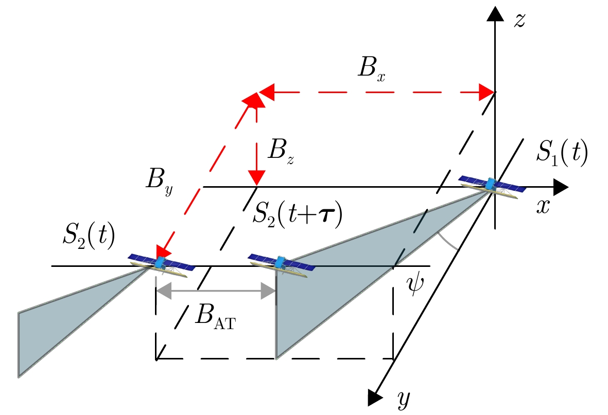
- Figure 2. Schematic diagram of the geometry of a hybrid baseline strabismus satellite
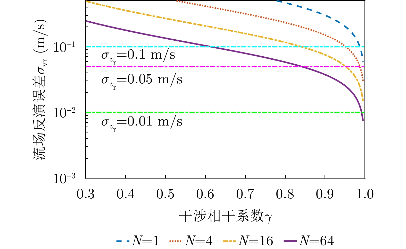
- Figure 3. OSC measurement error variation with coherence coefficient under different multi-look numbers
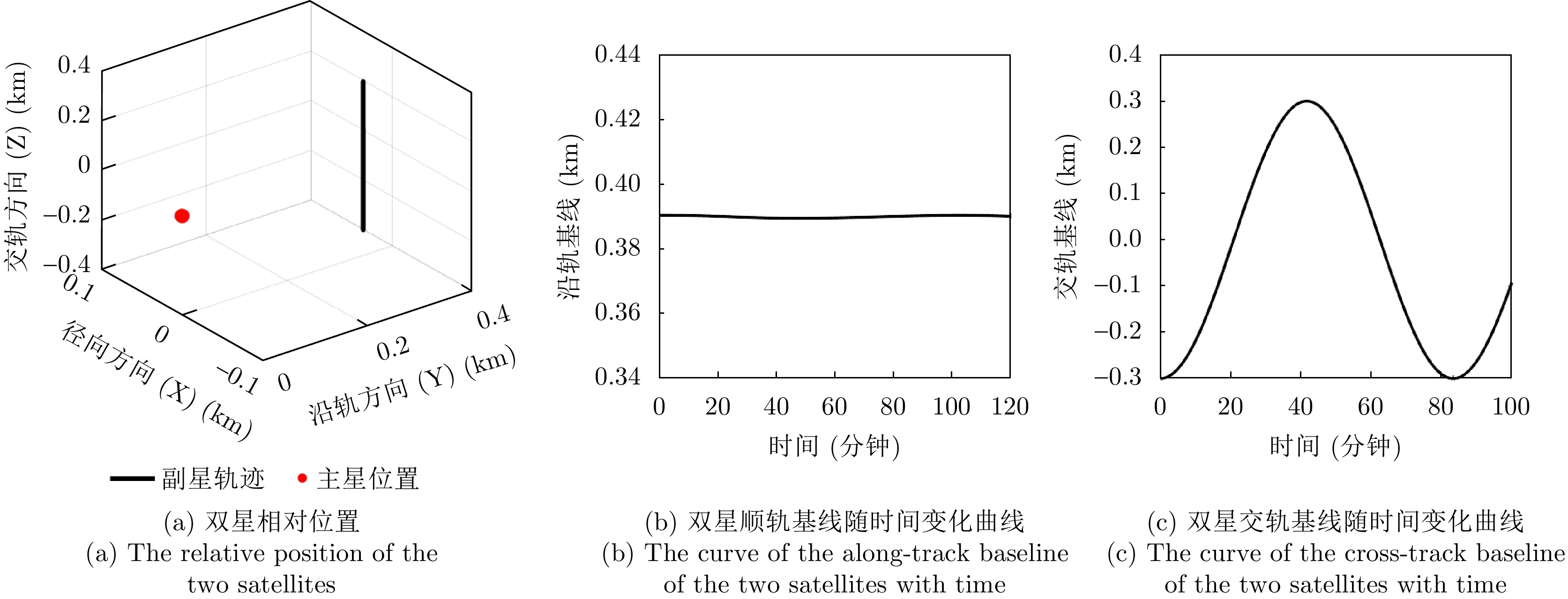
- Figure 4. Schematic diagram of relative position and baseline of pendulum
- Figure 5. Schematic illustration of a representative geometric configuration for a distributed SAR system
- Figure 6. Single-baseline velocity measurement RMSE variation with effective baseline length
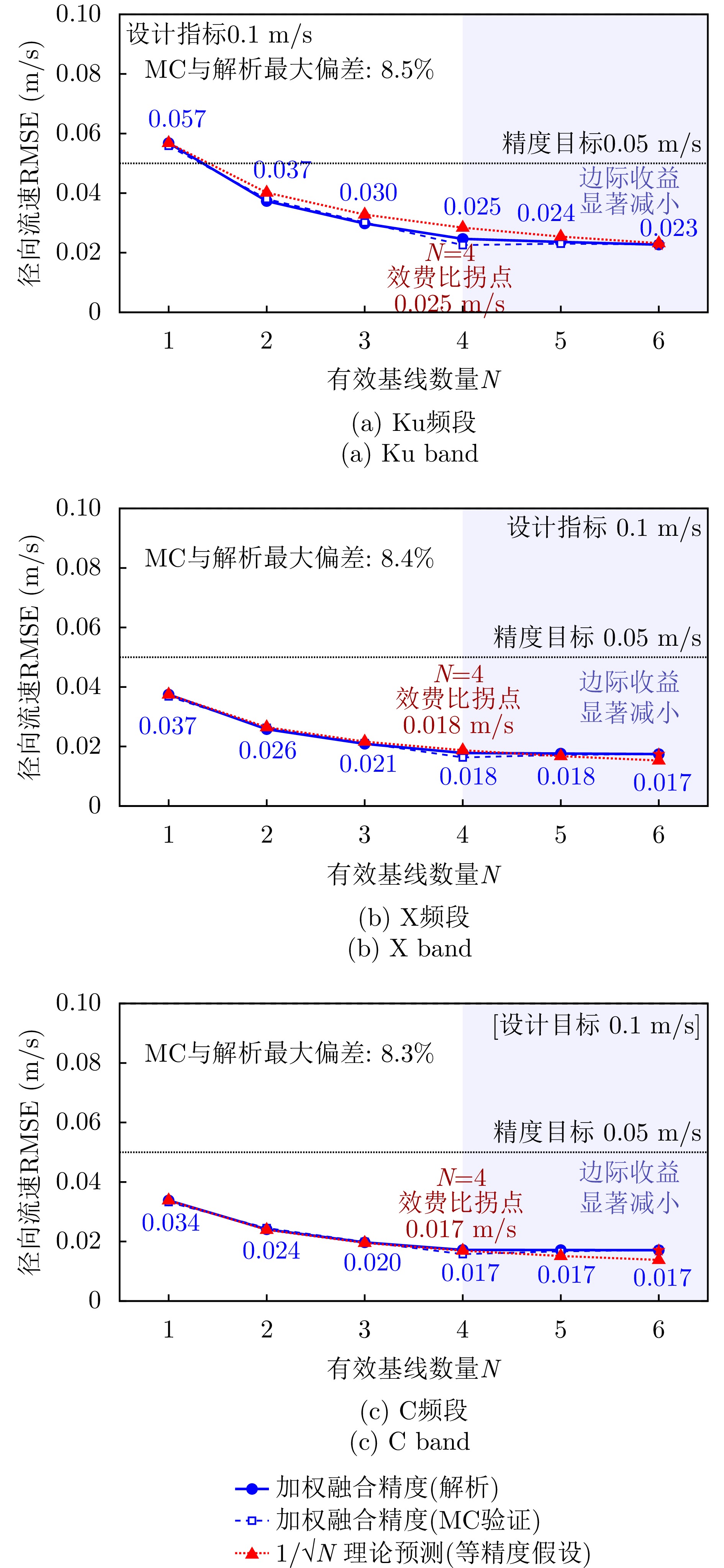
- Figure 7. Convergence characteristics of multi-baseline weighted fusion accuracy with the number of baselines
- Figure 8. Schematic of the variation curve of multi-baseline weighted fusion accuracy with baseline number under different sea states