
 Submit Manuscript
 Peer Review
 Editor Work
- Home
- Articles & Issues
-
Data
- Dataset of Radar Detecting Sea
- SAR Dataset
- SARGroundObjectsTypes
- SARMV3D
- AIRSAT Constellation SAR Land Cover Classification Dataset
- 3DRIED
- UWB-HA4D
- LLS-LFMCWR
- FAIR-CSAR
- MSAR
- SDD-SAR
- FUSAR
- SpaceborneSAR3Dimaging
- Sea-land Segmentation
- SAR Multi-domain Ship Detection Dataset
- SAR-Airport
- Hilly and mountainous farmland time-series SAR and ground quadrat dataset
- SAR images for interference detection and suppression
- HP-SAR Evaluation & Analytical Dataset
- GDHuiYan-ATRNet
- Multi-System Maritime Low Observable Target Dataset
- DatasetinthePaper
- DatasetintheCompetition
- Report
- Course
- About
- Publish
- Editorial Board
- Chinese
Article Navigation >
Journal of Radars
>
2026
> Online First
| Citation: | GUAN Shaoyang, WANG Chao, ZOU Lichuan, et al. An InSAR tropospheric delay correction method based on a spatially adaptive anchor network and local turbulence interpolation[J]. Journal of Radars, in press. doi: 10.12000/JR26039

|
An InSAR Tropospheric Delay Correction Method Based on a Spatially Adaptive Anchor Network and Local Turbulence Interpolation
DOI: 10.12000/JR26039 CSTR: 32380.14.JR26039
More Information-
Abstract
Tropospheric delay is a major error source in Interferometric Synthetic Aperture Radar (InSAR) and significantly limits its ability to retrieve accurate surface displacements, particularly in regions with complex topography or strong atmospheric heterogeneity. Existing correction methods are constrained by either the coarse resolution of external data or their inability to model deformation-elevation coupling and complex turbulent effects. To address these challenges, this paper proposes a tropospheric correction method based on a spatially adaptive anchor network. A Comprehensive Quality Index (CQI), combining phase stability and temporal coherence, is used along with an iterative spatial selection strategy to construct a quality-driven anchor network. Within each anchor neighborhood, a local joint inversion model is developed to effectively separate deformation, topographic residuals, and tropospheric delay. Additionally, a Local Turbulence Intensity (LTI) factor is introduced to suppress error propagation from high-turbulence regions during interpolation. Validation using Sentinel-1 data from Hawaii and the Qinghai-Tibet Plateau demonstrates that the proposed method reduces the interferogram phase standard deviation by more than 73%, outperforming conventional methods. The root mean square error between InSAR and GPS time-series displacements decreases from 44.4 to 9.3 mm after correction, representing a 79% improvement in consistency. The proposed method effectively mitigates tropospheric delay, enhances the accuracy of InSAR measurements, and improves the reliability of deformation monitoring across diverse terrain conditions. -

-
References
[1] WANG Chao, TANG Yixian, ZHANG Hong, et al. First mapping of China surface movement using supercomputing interferometric SAR technique[J]. Science Bulletin, 2021, 66(16): 1608–1610. doi: 10.1016/j.scib.2021.04.026.[2] AO Zurui, HU Xiaomei, TAO Shengli, et al. A national-scale assessment of land subsidence in China’s major cities[J]. Science, 2024, 384(6693): 301–306. doi: 10.1126/science.adl4366.[3] TAY C, LINDSEY E O, CHIN Shitong, et al. Sea-level rise from land subsidence in major coastal cities[J]. Nature Sustainability, 2022, 5(12): 1049–1057. doi: 10.1038/s41893-022-00947-z.[4] 云烨, 吕孝雷, 付希凯, 等. 星载InSAR技术在地质灾害监测领域的应用[J]. 雷达学报, 2020, 9(1): 73–85. doi: 10.12000/JR20007.YUN Ye, LÜ Xiaolei, FU Xikai, et al. Application of spaceborne interferometric synthetic aperture radar to geohazard monitoring[J]. Journal of Radars, 2020, 9(1): 73–85. doi: 10.12000/JR20007.[5] MASSONNET D, FEIGL K, ROSSI M, et al. Radar interferometric mapping of deformation in the year after the Landers earthquake[J]. Nature, 1994, 369(6477): 227–230. doi: 10.1038/369227a0.[6] ZHU Chuanhua, LI Xue, WANG Chisheng, et al. Deep learning-based coseismic deformation estimation from InSAR interferograms[J]. IEEE Transactions on Geoscience and Remote Sensing, 2024, 62: 5203610. doi: 10.1109/TGRS.2024.3357190.[7] LU Zhong and DZURISIN D. InSAR Imaging of Aleutian volcanoes[M]. LU Zhong and DZURISIN D. InSAR Imaging of Aleutian Volcanoes: Monitoring a Volcanic Arc from Space. Berlin, Heidelberg: Springer, 2014: 87–345. doi: 10.1007/978-3-642-00348-6_6.[8] ANANTRASIRICHAI N, BIGGS J, ALBINO F, et al. Application of machine learning to classification of volcanic deformation in routinely generated InSAR data[J]. Journal of Geophysical Research: Solid Earth, 2018, 123(8): 6592–6606. doi: 10.1029/2018JB015911.[9] DELGADO F, SHREVE T, BORGSTROM S, et al. A global assessment of SAOCOM-1 L-band stripmap data for InSAR characterization of volcanic, tectonic, cryospheric, and anthropogenic deformation[J]. IEEE Transactions on Geoscience and Remote Sensing, 2024, 62: 5216821. doi: 10.1109/TGRS.2024.3423792.[10] ZOU Lichuan, WANG Chao, ZHANG Hong, et al. Landslide-prone area retrieval and earthquake-inducing hazard probability assessment based on InSAR analysis[J]. Landslides, 2023, 20(9): 1989–2002. doi: 10.1007/s10346-023-02079-7.[11] ZHOU Chao, CAO Ying, GAN Lulu, et al. A novel framework for landslide displacement prediction using MT-InSAR and machine learning techniques[J]. Engineering Geology, 2024, 334: 107497. doi: 10.1016/j.enggeo.2024.107497.[12] GUAN Shaoyang, WANG Chao, TANG Yixian, et al. North American Circum-arctic permafrost degradation observation using sentinel-1 InSAR data[J]. Remote Sensing, 2024, 16(15): 2809. doi: 10.3390/rs16152809.[13] WANG Chao, ZHANG Zhengjia, ZHANG Hong, et al. Active layer thickness retrieval of Qinghai-Tibet permafrost using the TerraSAR-X InSAR technique[J]. IEEE Journal of Selected Topics in Applied Earth Observations and Remote Sensing, 2018, 11(11): 4403–4413. doi: 10.1109/JSTARS.2018.2873219.[14] ZEBKER H A, ROSEN P A, and HENSLEY S. Atmospheric effects in interferometric synthetic aperture radar surface deformation and topographic maps[J]. Journal of Geophysical Research: Solid Earth, 1997, 102(B4): 7547–7563. doi: 10.1029/96JB03804.[15] LI Zhiwei, CAO Yunmeng, WEI Jianchao, et al. Time-series InSAR ground deformation monitoring: Atmospheric delay modeling and estimating[J]. Earth-Science Reviews, 2019, 192: 258–284. doi: 10.1016/j.earscirev.2019.03.008.[16] MA Peifeng, YU Chang, JIAO Zeyu, et al. Improving time-series InSAR deformation estimation for city clusters by deep learning-based atmospheric delay correction[J]. Remote Sensing of Environment, 2024, 304: 114004. doi: 10.1016/j.rse.2024.114004.[17] HE Xin, LI Zhiwei, MU Minzheng, et al. Refining stacking-InSAR by considering the statistical characteristics of atmospheric turbulence[J]. IEEE Transactions on Geoscience and Remote Sensing, 2024, 62: 5215714. doi: 10.1109/TGRS.2024.3418824.[18] HE Xin, LI Zhiwei, MU Minzheng, et al. Advanced tropospheric delay mitigation method using InSAR-based iterative decomposition by considering the statistical characteristics of atmospheric turbulence[J]. IEEE Transactions on Geoscience and Remote Sensing, 2024, 62: 5204710. doi: 10.1109/TGRS.2024.3353778.[19] CAO Yunmeng, JÓNSSON S, and LI Zhiwei. Advanced InSAR tropospheric corrections from global atmospheric models that incorporate spatial stochastic properties of the troposphere[J]. Journal of Geophysical Research: Solid Earth, 2021, 126(5): e2020JB020952. doi: 10.1029/2020JB020952.[20] MULDER G, VAN LEIJEN F J, and HANSSEN R F. A generic approach to parameterize the turbulent energy of single-epoch atmospheric delays from InSAR time series[J]. IEEE Transactions on Geoscience and Remote Sensing, 2023, 61: 5212413. doi: 10.1109/TGRS.2023.3295898.[21] ONN F and ZEBKER H A. Correction for interferometric synthetic aperture radar atmospheric phase artifacts using time series of zenith wet delay observations from a GPS network[J]. Journal of Geophysical Research: Solid Earth, 2006, 111(B9): B09102. doi: 10.1029/2005JB004012.[22] LI Zhenhong, MULLER J P, CROSS P, et al. Interferometric Synthetic Aperture Radar (InSAR) atmospheric correction: GPS, moderate resolution imaging spectroradiometer (MODIS), and InSAR integration[J]. Journal of Geophysical Research: Solid Earth, 2005, 110(B3): B03410. doi: 10.1029/2004JB003446.[23] DOIN M P, LASSERRE C, PELTZER G, et al. Corrections of stratified tropospheric delays in SAR interferometry: Validation with global atmospheric models[J]. Journal of Applied Geophysics, 2009, 69(1): 35–50. doi: 10.1016/j.jappgeo.2009.03.010.[24] ZHANG Xuesong, LI Zhenhong, and LIU Zhenjiang. Reduction of atmospheric effects on InSAR observations through incorporation of GACOS and PCA into small baseline subset InSAR[J]. IEEE Transactions on Geoscience and Remote Sensing, 2023, 61: 5209115. doi: 10.1109/TGRS.2023.3281783.[25] LIU Qinghua, ZENG Qiming, and ZHANG Zhiliang. Evaluation of InSAR tropospheric correction by using efficient WRF simulation with ERA5 for initialization[J]. Remote Sensing, 2023, 15(1): 273. doi: 10.3390/rs15010273.[26] MURRAY K D, BEKAERT D P S, and LOHMAN R B. Tropospheric corrections for InSAR: Statistical assessments and applications to the central united states and Mexico[J]. Remote Sensing of Environment, 2019, 232: 111326. doi: 10.1016/j.rse.2019.111326.[27] MA Yongchao, LIU Tong, YU Zhibin, et al. Assessment of numerical weather models with different spatial resolutions on tropospheric delay correction for InSAR[J]. IEEE Journal of Selected Topics in Applied Earth Observations and Remote Sensing, 2024, 17: 14133–14144. doi: 10.1109/JSTARS.2024.3440648.[28] OLIVER-CABRERA T, JONES C E, SIMARD M, et al. Identifying wet troposphere delay in L-band InSAR using weather radar reflectivity[J]. Earth and Space Science, 2025, 12(7): e2025EA004382. doi: 10.1029/2025EA004382.[29] HOOPER A, ZEBKER H, SEGALL P, et al. A new method for measuring deformation on volcanoes and other natural terrains using InSAR persistent scatterers[J]. Geophysical Research Letters, 2004, 31(23): L23611. doi: 10.1029/2004GL021737.[30] BERARDINO P, FORNARO G, LANARI R, et al. A new algorithm for surface deformation monitoring based on small baseline differential SAR interferograms[J]. IEEE Transactions on Geoscience and Remote Sensing, 2002, 40(11): 2375–2383. doi: 10.1109/TGRS.2002.803792.[31] ZHANG Zhichao, FENG Wanpeng, XU Xiaohua, et al. Performance of common scene stacking atmospheric correction on nonlinear InSAR deformation retrieval[J]. Remote Sensing, 2023, 15(22): 5399. doi: 10.3390/rs15225399.[32] GUO Shipeng, ZUO Xiaoqing, ZHANG Jihong, et al. Mountain landslide monitoring using a DS-InSAR method incorporating a spatio-temporal atmospheric phase screen correction model[J]. Remote Sensing, 2024, 16(22): 4228. doi: 10.3390/rs16224228.[33] BEKAERT D P S, HOOPER A, and WRIGHT T J. A spatially variable power law tropospheric correction technique for InSAR data[J]. Journal of Geophysical Research: Solid Earth, 2015, 120(2): 1345–1356. doi: 10.1002/2014JB011558.[34] LEE J C and SHIRZAEI M. Novel algorithms for pair and pixel selection and atmospheric error correction in multitemporal InSAR[J]. Remote Sensing of Environment, 2023, 286: 113447. doi: 10.1016/j.rse.2022.113447.[35] ZHOU Hao, DAI Keren, PIRASTEH S, et al. InSAR spatial-heterogeneity tropospheric delay correction in steep mountainous areas based on deep learning for landslides monitoring[J]. IEEE Transactions on Geoscience and Remote Sensing, 2023, 61: 5215014. doi: 10.1109/TGRS.2023.3307477.[36] FALABELLA F, PERRONE A, STABILE T A, et al. Atmospheric phase screen compensation on wrapped ground-based SAR interferograms[J]. IEEE Transactions on Geoscience and Remote Sensing, 2022, 60: 5202115. doi: 10.1109/TGRS.2021.3055648.[37] WANG Yian, DONG Jie, ZHANG Lu, et al. Refined InSAR tropospheric delay correction for wide-area landslide identification and monitoring[J]. Remote Sensing of Environment, 2022, 275: 113013. doi: 10.1016/j.rse.2022.113013.[38] WU Kefu, ZHU Jianjun, FU Haiqiang, et al. InSAR Dem block adjustment considering atmospheric effects[C]. 2024 IEEE International Geoscience and Remote Sensing Symposium, Athens, Greece, 2024: 4570–4573. doi: 10.1109/IGARSS53475.2024.10641753.[39] DENG Yunkai, HU Cheng, TIAN Weiming, et al. A grid partition method for atmospheric phase compensation in GB-SAR[J]. IEEE Transactions on Geoscience and Remote Sensing, 2022, 60: 5206713. doi: 10.1109/TGRS.2021.3074161.[40] MURRAY K D, LOHMAN R B, and BEKAERT D P S. Cluster-based empirical tropospheric corrections applied to InSAR time series analysis[J]. IEEE Transactions on Geoscience and Remote Sensing, 2021, 59(3): 2204–2212. doi: 10.1109/TGRS.2020.3003271.[41] LIANG Hongyu, ZHANG Lei, DING Xiaoli, et al. Toward mitigating stratified tropospheric delays in multitemporal InSAR: A quadtree aided joint model[J]. IEEE Transactions on Geoscience and Remote Sensing, 2019, 57(1): 291–303. doi: 10.1109/TGRS.2018.2853706.[42] LIANG Hongyu, ZHANG Lei, LU Zhong, et al. Correction of spatially varying stratified atmospheric delays in multitemporal InSAR[J]. Remote Sensing of Environment, 2023, 285: 113382. doi: 10.1016/j.rse.2022.113382.[43] 占文俊, 李志伟, 韦建超, 等. 一种InSAR大气相位建模与估计方法[J]. 地球物理学报, 2015, 58(7): 2320–2329. doi: 10.6038/cjg20150710.ZHAN Wenjun, LI Zhiwei, WEI Jianchao, et al. A strategy for modeling and estimating atmospheric phase of SAR interferogram[J]. Chinese Journal of Geophysics, 2015, 58(7): 2320–2329. doi: 10.6038/cjg20150710.[44] LI Menghua, HUANG Dongxu, YANG Mengshi, et al. Improving InSAR tropospheric delay correction in deep canyon regions with a DEM watershed-based segmented linear model[J]. IEEE Journal of Selected Topics in Applied Earth Observations and Remote Sensing, 2025, 18: 16868–16878. doi: 10.1109/JSTARS.2025.3584821.[45] BRENCHER G, HENDERSON S T, and SHEAN D E. Removing atmospheric noise from InSAR interferograms in mountainous regions with a convolutional neural network[J]. Computers & Geosciences, 2025, 194: 105771. doi: 10.1016/j.cageo.2024.105771.[46] YU Chen, LI Zhenhong, PENNA N T, et al. Generic atmospheric correction model for interferometric synthetic aperture radar observations[J]. Journal of Geophysical Research: Solid Earth, 2018, 123(10): 9202–9222. doi: 10.1029/2017JB015305.[47] AURENHAMMER F. Voronoi diagrams—a survey of a fundamental geometric data structure[J]. ACM Computing Surveys (CSUR), 1991, 23(3): 345–405. doi: 10.1145/116873.116880.[48] LIESEN J, ROZLOZNÍK M, and STRAKOS Z. Least squares residuals and minimal residual methods[J]. SIAM Journal on Scientific Computing, 2002, 23(5): 1503–1525. doi: 10.1137/S1064827500377988.[49] REFICE A, BOVENGA F, and NUTRICATO R. MST-based stepwise connection strategies for multipass radar data, with application to coregistration and equalization[J]. IEEE Transactions on Geoscience and Remote Sensing, 2006, 44(8): 2029–2040. doi: 10.1109/TGRS.2006.872907.[50] ZHANG Yunjun, FATTAHI H, and AMELUNG F. Small baseline InSAR time series analysis: Unwrapping error correction and noise reduction[J]. Computers & Geosciences, 2019, 133: 104331. doi: 10.1016/j.cageo.2019.104331.[51] HOGENSON K, ARKO S A, BUECHLER B, et al. Hybrid pluggable processing pipeline (HyP3): A cloud-based infrastructure for generic processing of SAR data[C]. American Geophysical Union, Fall Meeting 2016, 2016: IN21B-1740.[52] VERNIER J P, KALNAJS L, DIAZ J A, et al. VolKilau: Volcano rapid response balloon campaign during the 2018 kilauea eruption[J]. Bulletin of the American Meteorological Society, 2020, 101(10): E1602–E1618. doi: 10.1175/BAMS-D-19-0011.1.[53] ZOU Lichuan, WANG Chao, TANG Yixian, et al. Interferometric SAR observation of permafrost status in the northern Qinghai-Tibet Plateau by ALOS, ALOS-2 and Sentinel-1 between 2007 and 2021[J]. Remote Sensing, 2022, 14(8): 1870. doi: 10.3390/rs14081870.[54] LIU Jihong, HU Jun, XU Wenbin, et al. Complete three-dimensional coseismic deformation field of the 2016 central Tottori earthquake by integrating left- and right-looking InSAR observations with the improved SM-VCE method[J]. Journal of Geophysical Research: Solid Earth, 2019, 124(11): 12099–12115. doi: 10.1029/2018JB017159. -
Proportional views


- Publishing Ethics
- Journal Insights
- Abstracting & Indexing
- Peer Review Policies
- Guide for Authors
- Conference
- ISSN 2095-283X (Print)ISSN 2097-339X (Online)
- CN 10-1030/TN
- CODEN LXEUAO
About Journal
- Sponsor: China Radio Detection and Ranging Industry Association (CRIA)
- Phone: 010-58887062
- Email:radars@aircas.ac.cn
- Publisher: Leida Xuebao Bianjibu (Editorial office of the Journal of Radars)
Contacts Us

京ICP备20021838号-14
Supported by: Beijing Renhe Information Technology Co. Ltd

Export File
Citation
Format
Content
 DownLoad:

- Figure 1. The workflow chart of the tropospheric delay correction method
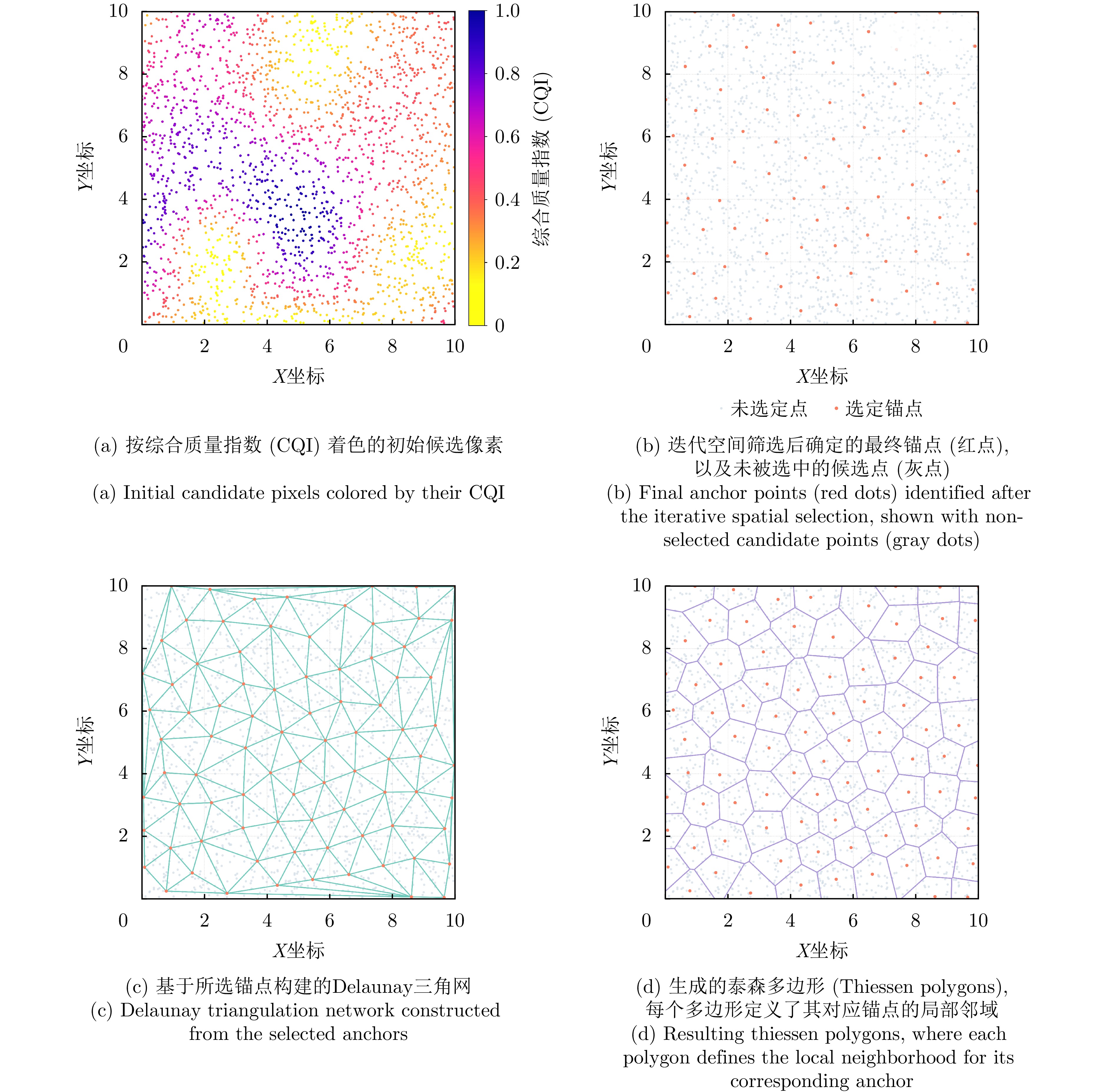
- Figure 2. Illustration of the adaptive anchor point selection and Voronoi neighborhood definition
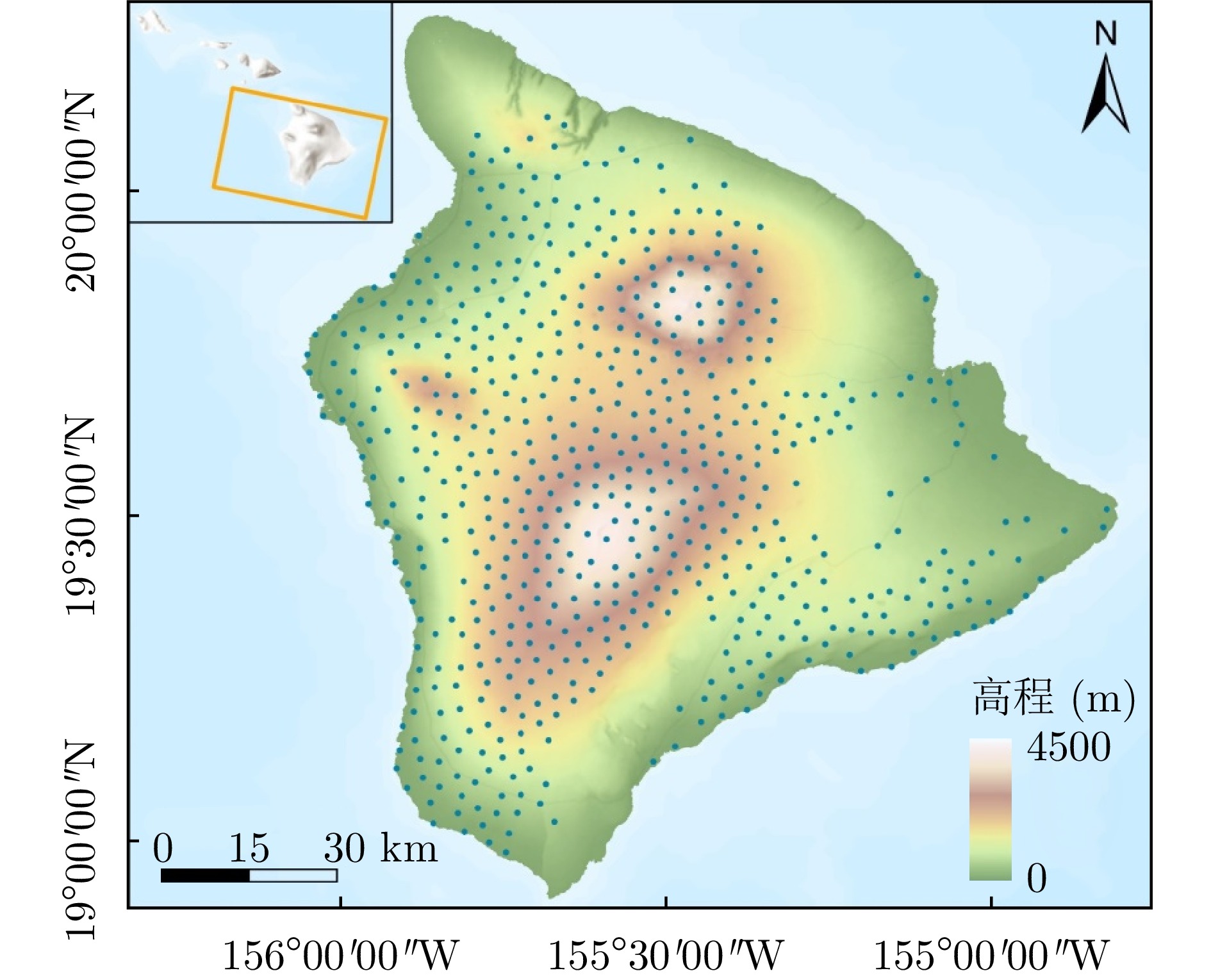
- Figure 3. Overview of the Hawaii study area and the distribution of the anchors (blue dots) selected by the proposed method
-
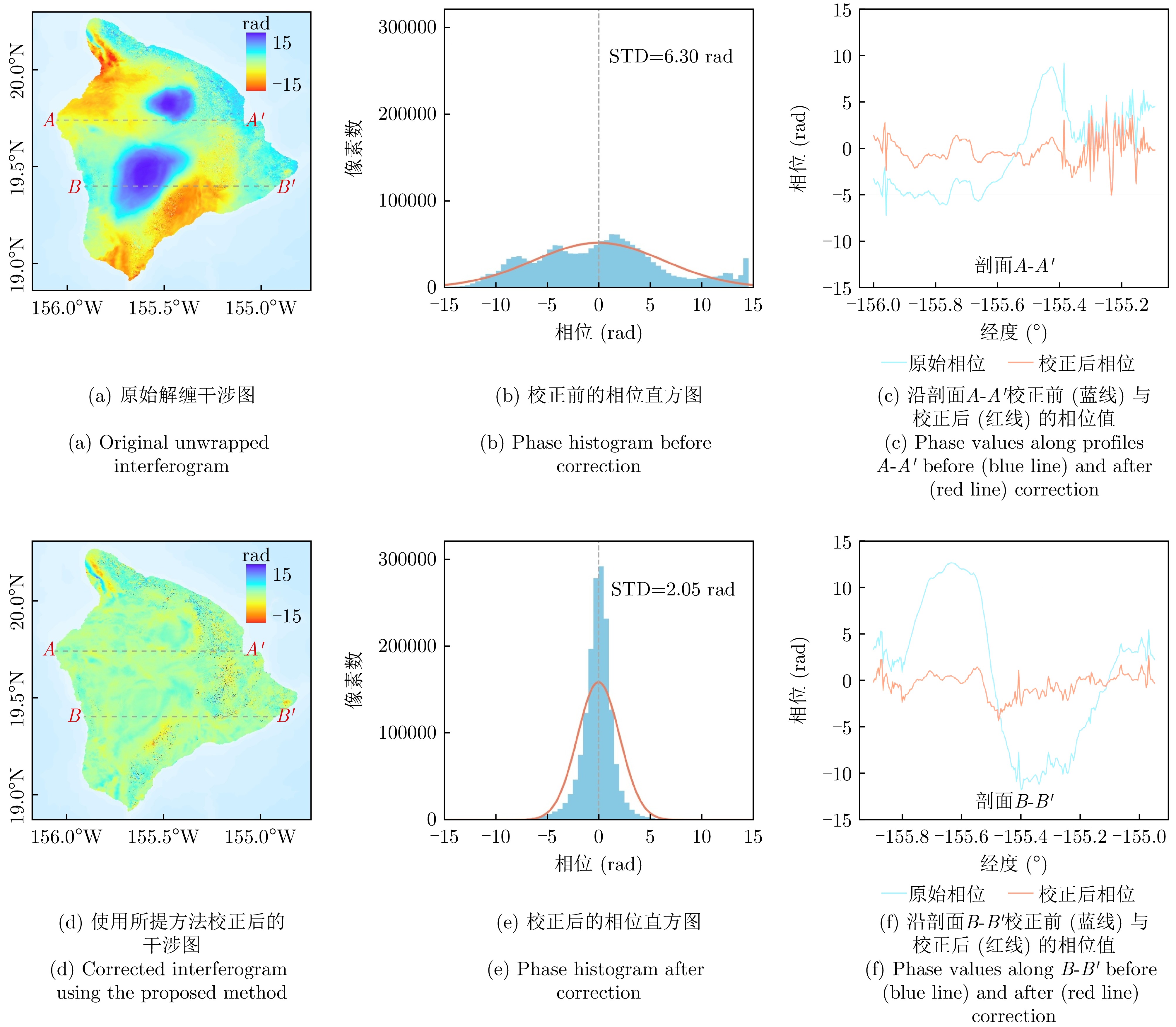
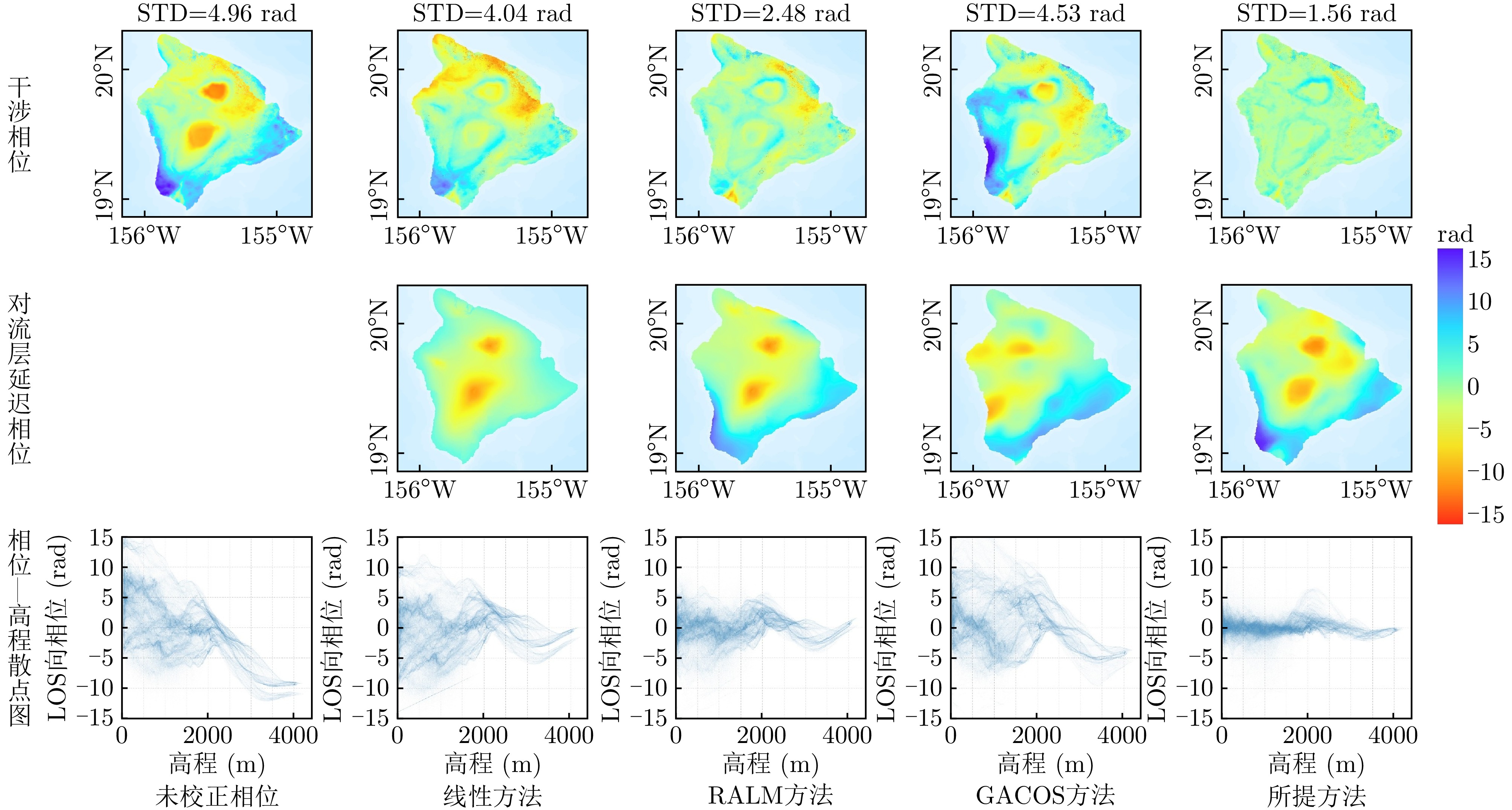
Figure 4. Example of tropospheric delay correction for an interferogram (
20170615 -20170627 ) in Hawaii -
Figure 5. Comparison of tropospheric delay correction results for a single interferogram (
20170826 -20170907 ) in Hawaii - Figure 6. Comparison of tropospheric delay correction results for three additional interferograms in Hawaii
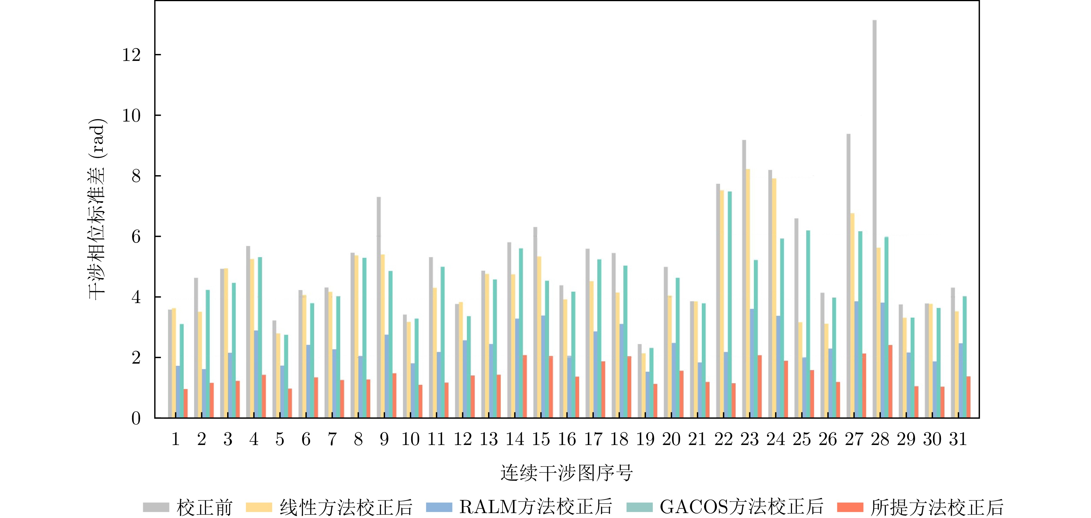
- Figure 7. Comparison of standard deviation for all interferograms in the Hawaii using different correction methods
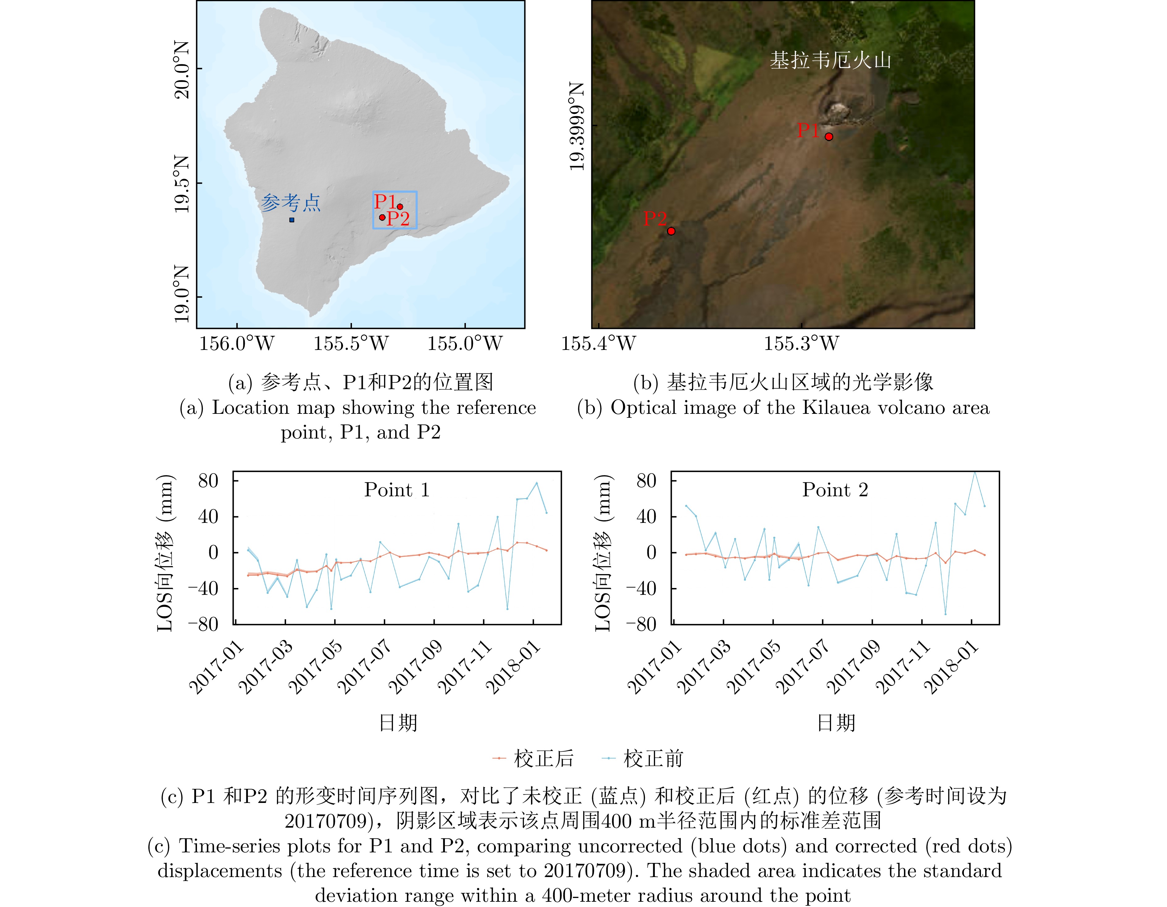
- Figure 8. Comparison of LOS deformation time-series before and after correction at two points (P1 and P2) near the Kilauea volcano
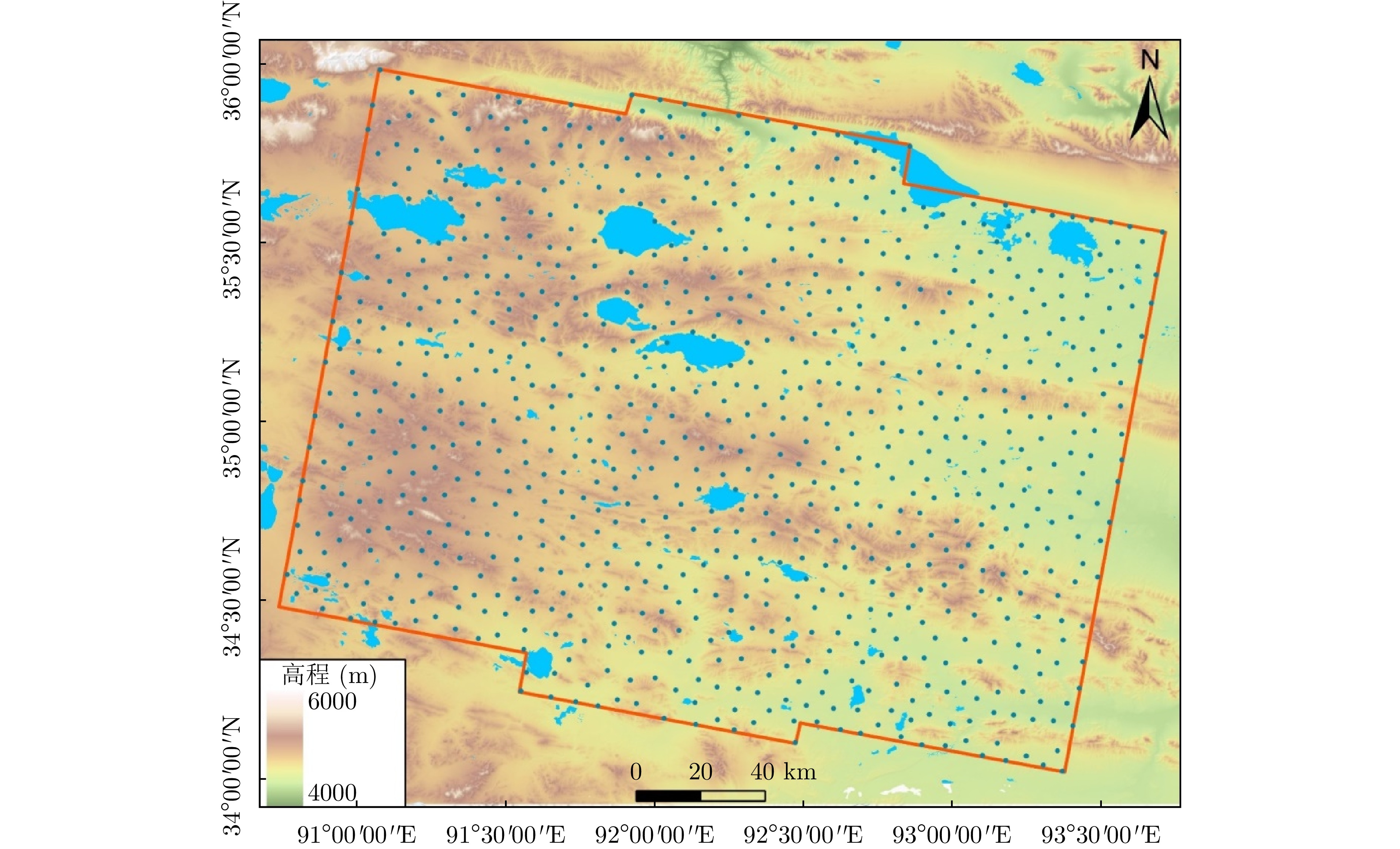
- Figure 9. Overview of the Beiluhe permafrost study area in the QTP and the distribution of the anchors (blue dots) selected by the proposed method
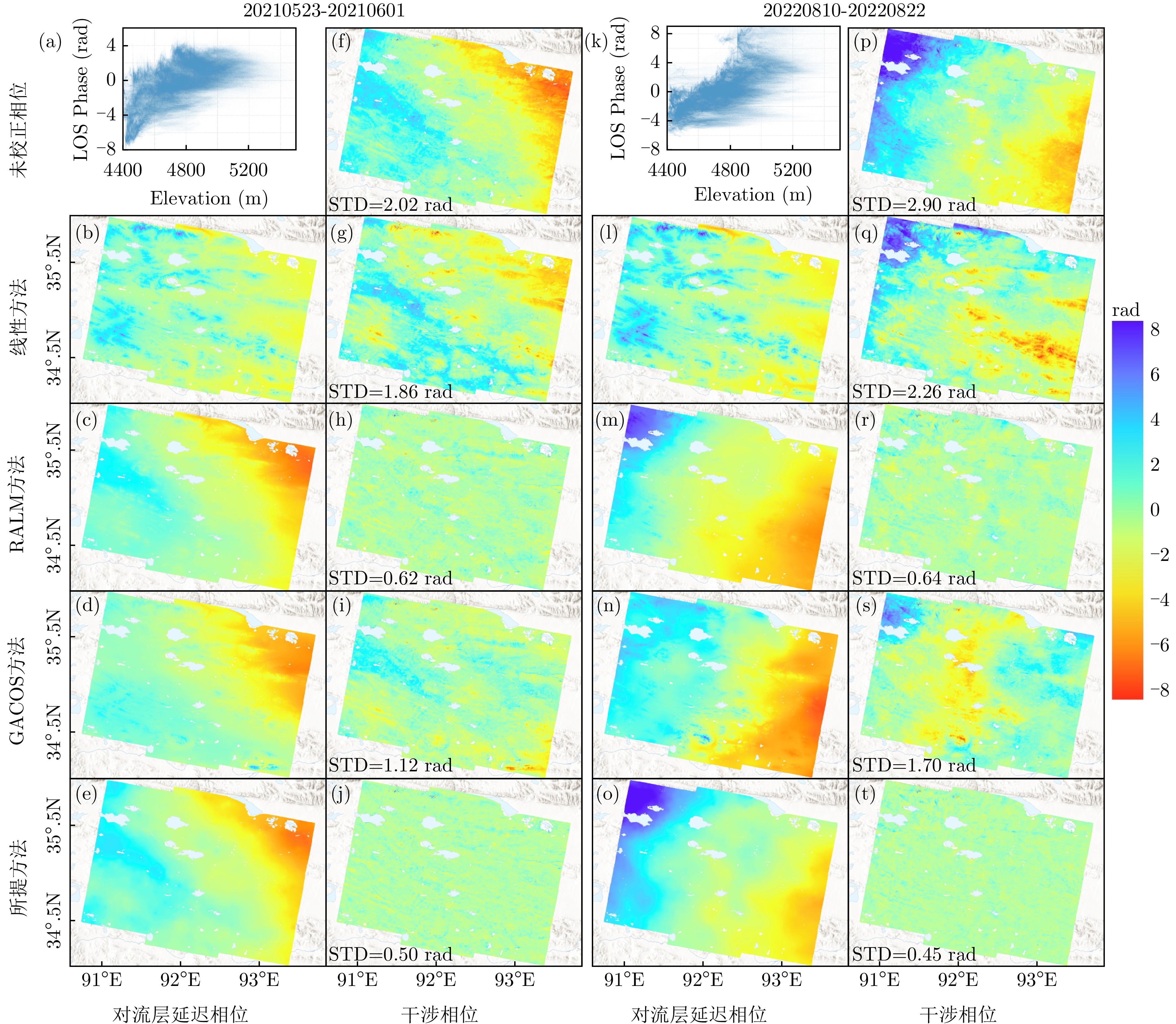
- Figure 10. Comparison of tropospheric delay correction results for two interferograms in the Beiluhe region
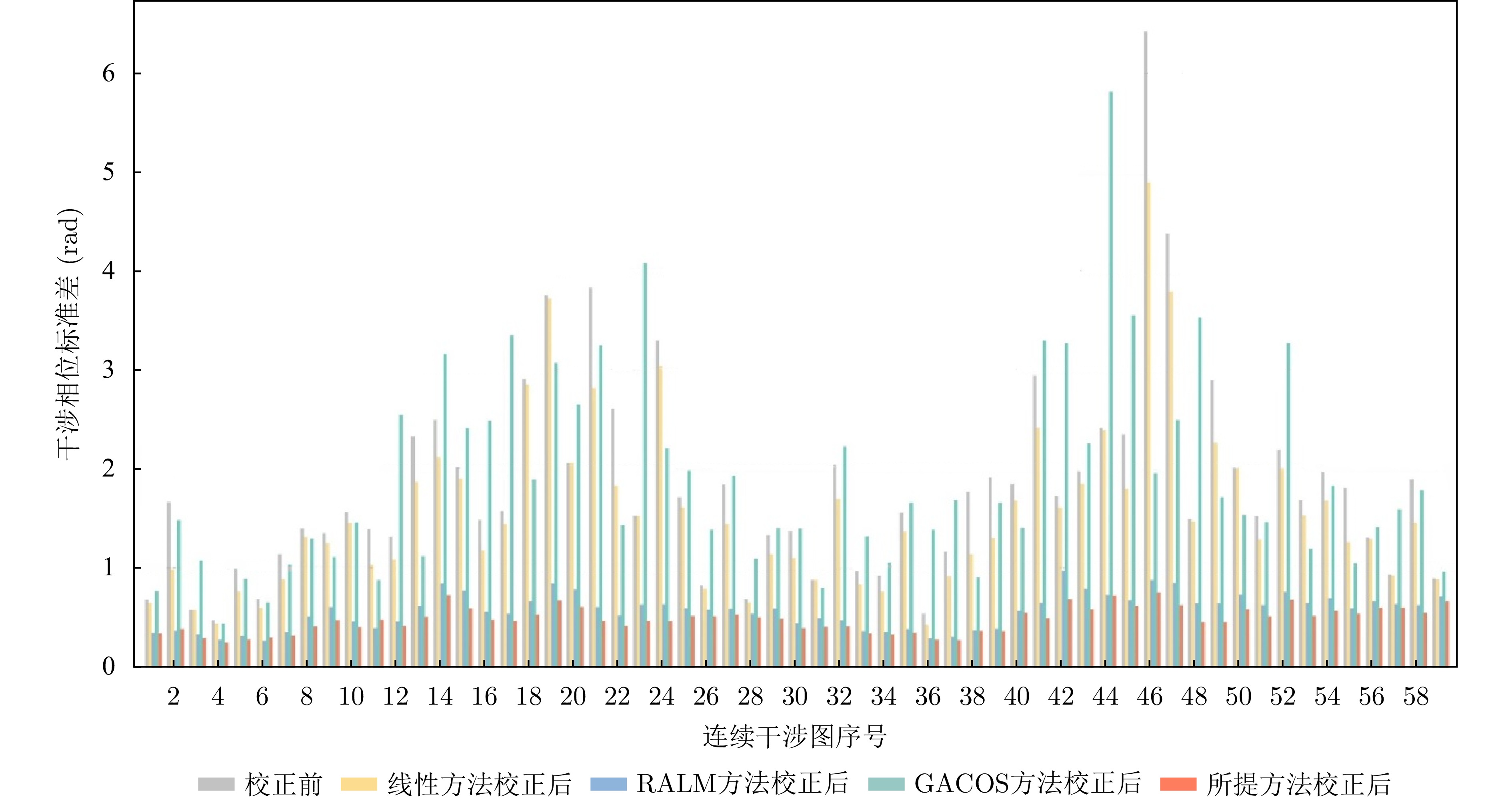
- Figure 11. Comparison of phase standard deviation for all 59 sequential interferograms in the Beiluhe study area
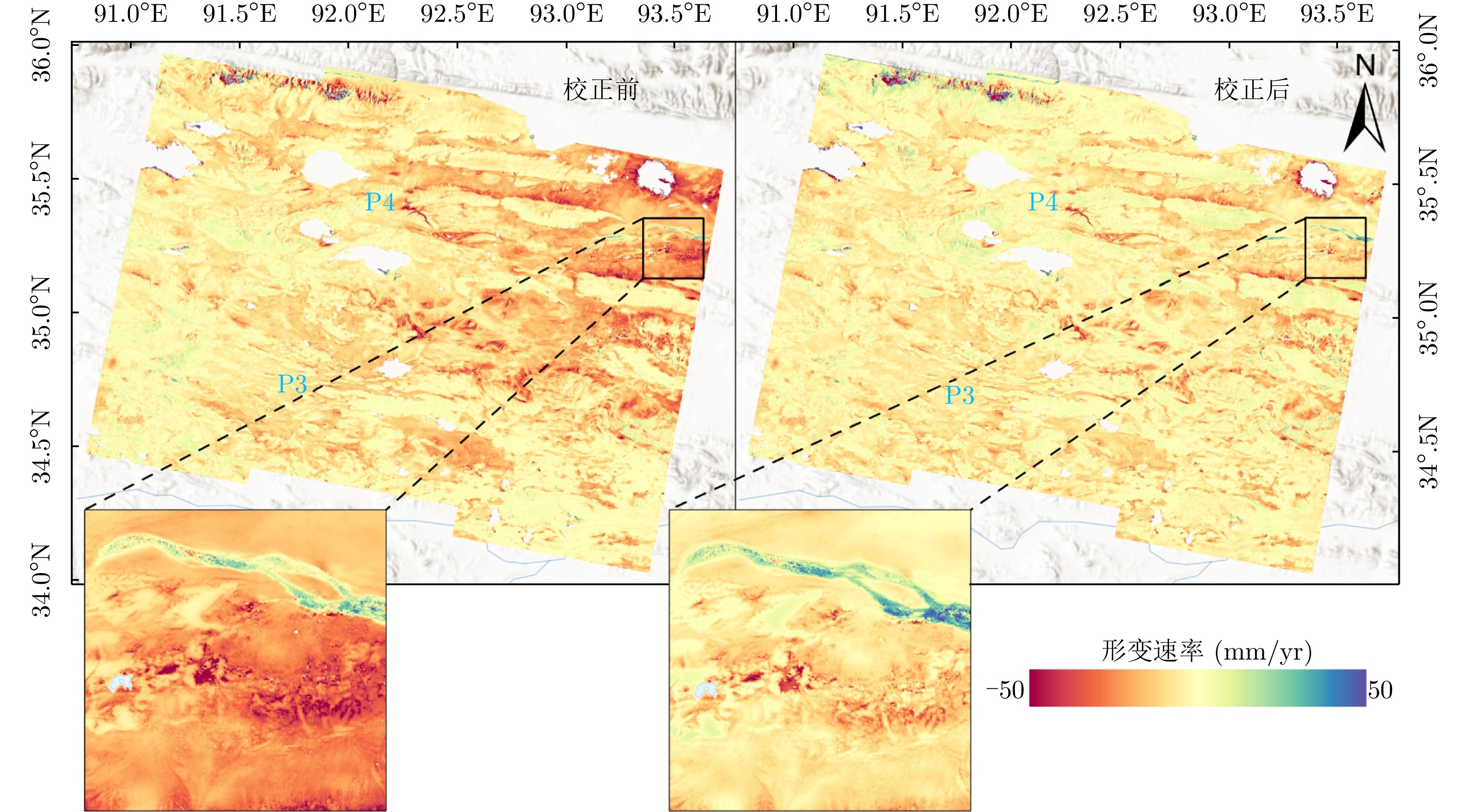
- Figure 12. Mean annual LOS deformation velocity maps for the Beiluhe study area before (left) and after (right) correction
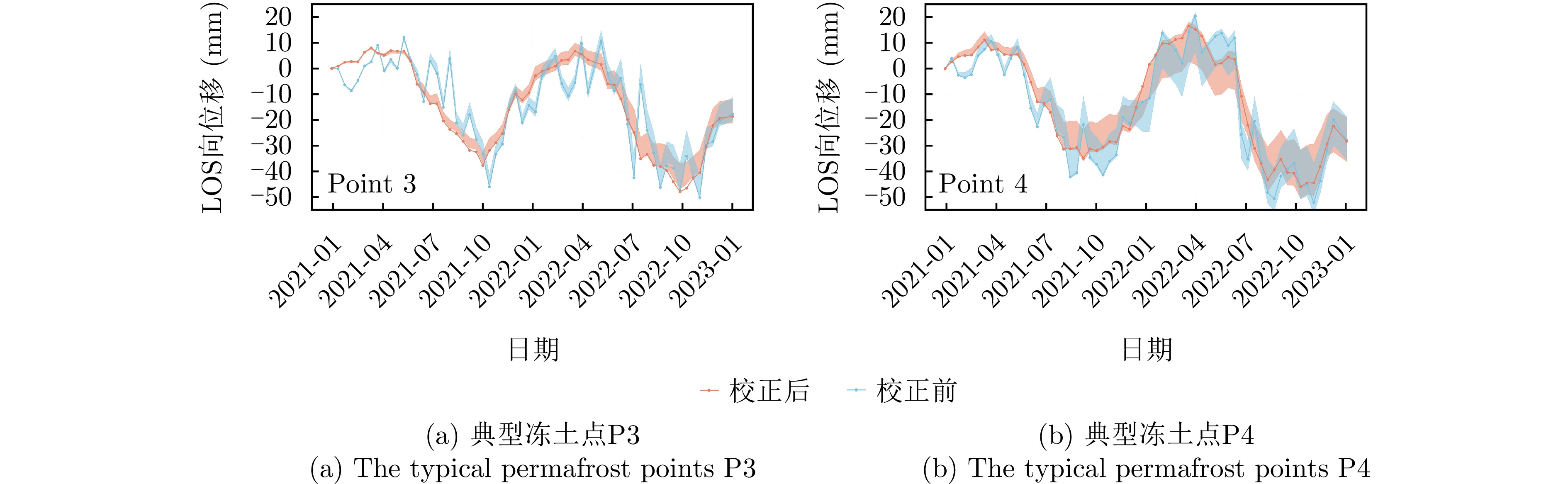
- Figure 13. Comparison of LOS deformation time-series before (blue shaded line) and after (red solid line) correction for two typical permafrost points (the shaded area indicates the standard deviation range within a 400-meter radius around the point)
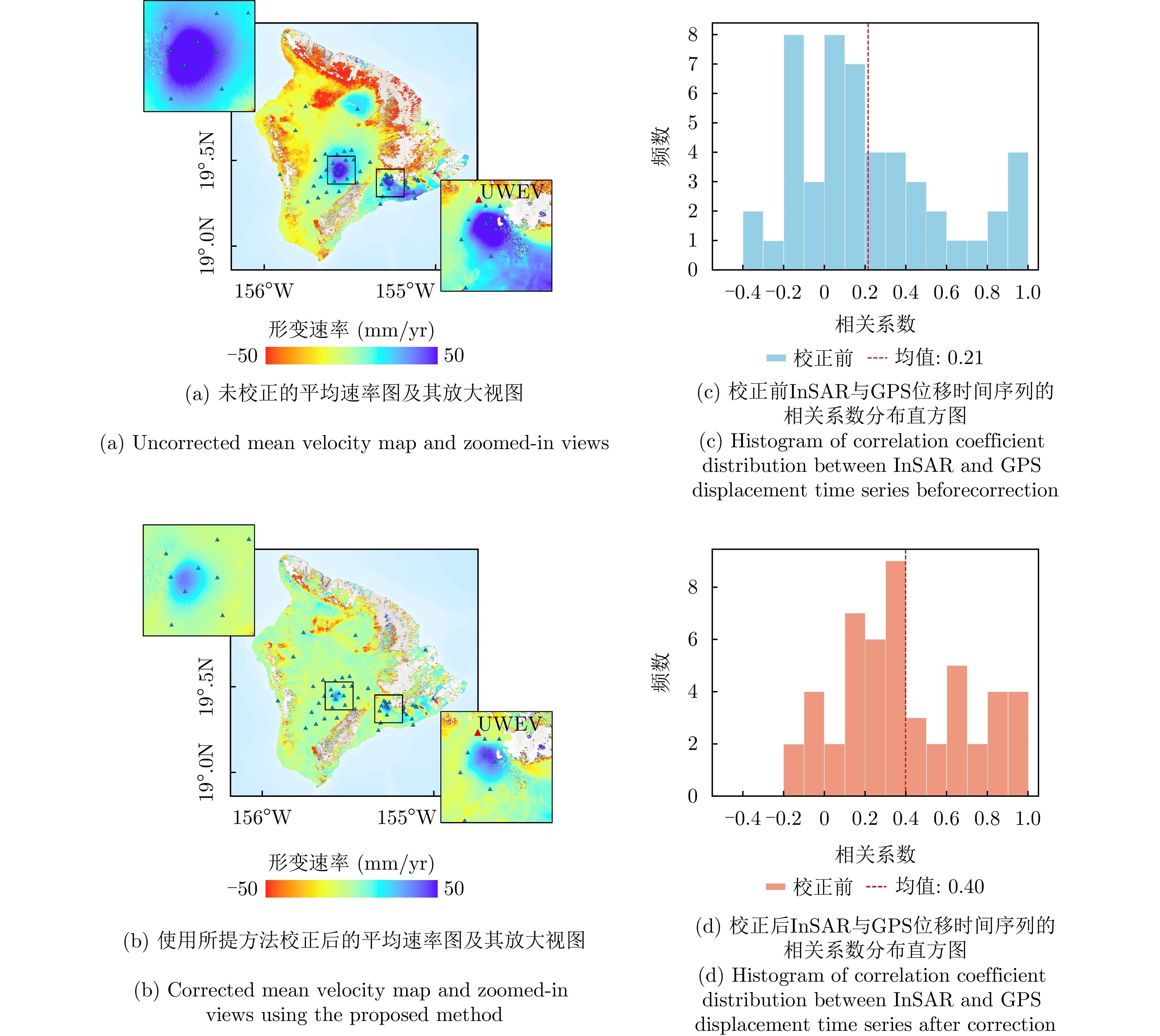
- Figure 14. Validation of InSAR results with GPS data in Hawaii (locations of GPS stations are represented by triangles)
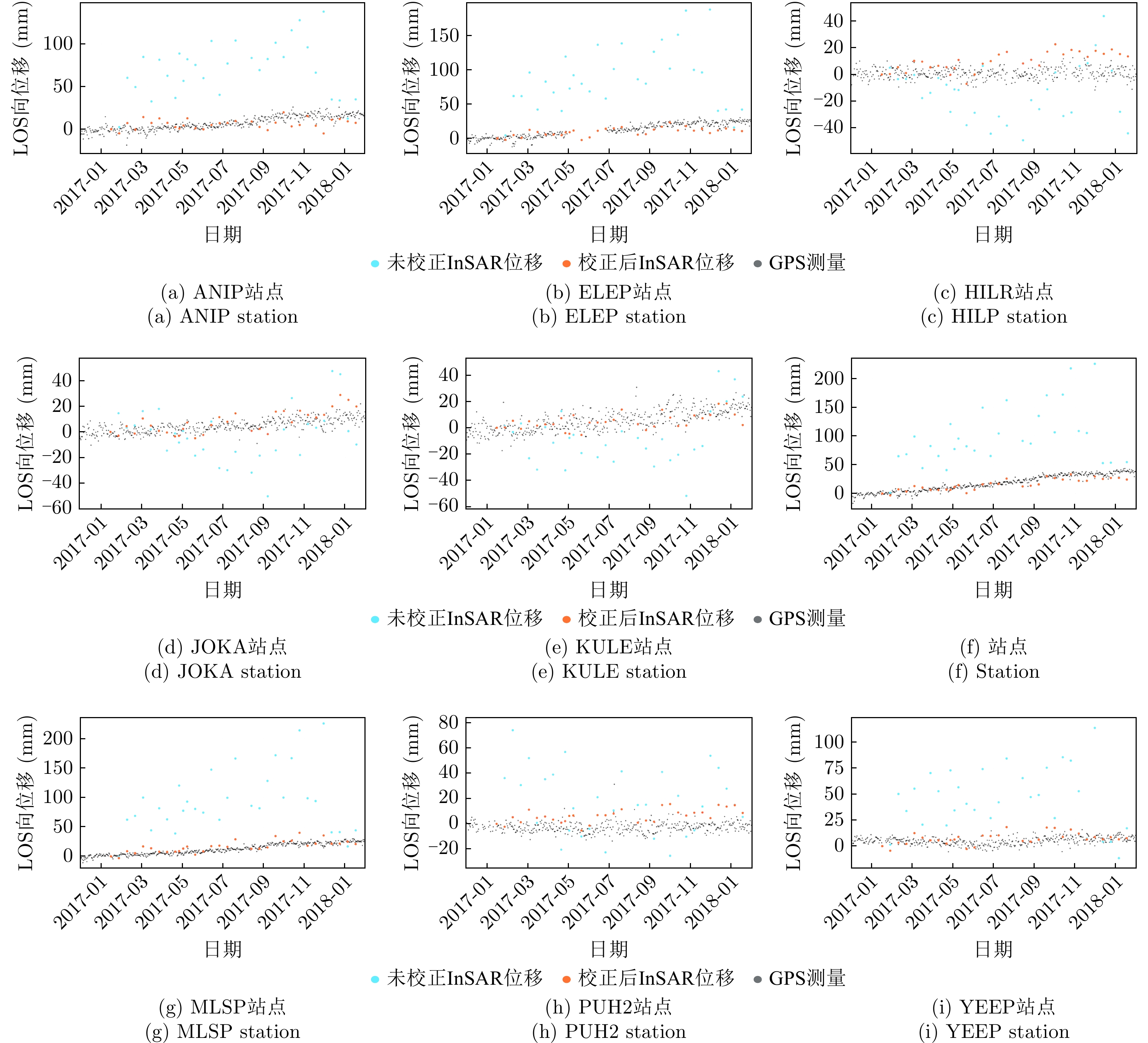
- Figure 15. Comparison of InSAR and GPS time-series displacements at 9 selected GPS stations