
 Submit Manuscript
 Peer Review
 Editor Work
- Home
- Articles & Issues
-
Data
- Dataset of Radar Detecting Sea
- SAR Dataset
- SARGroundObjectsTypes
- SARMV3D
- AIRSAT Constellation SAR Land Cover Classification Dataset
- 3DRIED
- UWB-HA4D
- LLS-LFMCWR
- FAIR-CSAR
- MSAR
- SDD-SAR
- FUSAR
- SpaceborneSAR3Dimaging
- Sea-land Segmentation
- SAR Multi-domain Ship Detection Dataset
- SAR-Airport
- Hilly and mountainous farmland time-series SAR and ground quadrat dataset
- SAR images for interference detection and suppression
- HP-SAR Evaluation & Analytical Dataset
- GDHuiYan-ATRNet
- Multi-System Maritime Low Observable Target Dataset
- DatasetinthePaper
- DatasetintheCompetition
- Report
- Course
- About
- Publish
- Editorial Board
- Chinese
| Citation: | WANG Youjun, DONG Zhen, WANG Xiantao, et al. Three-dimensional tomographic imaging of urban buildings and structures using chinese commercial SAR satellite data[J]. Journal of Radars, 2026, 15(2): 727–745. doi: 10.12000/JR25098

|
Three-dimensional Tomographic Imaging of Urban Buildings and Structures Using Chinese Commercial SAR Satellite Data
DOI: 10.12000/JR25098 CSTR: 32380.14.JR25098
More Information-
Abstract
A single Synthetic Aperture Radar (SAR) image can capture only two-dimensional information, and traditional multitemporal Interferometric SAR (InSAR) techniques struggle with the layover problem, particularly in urban areas. SAR Tomography (TomoSAR) provides the advantage of obtaining three-dimensional (3-D) information while offering a feasible solution to the layover problem. This technique relies on repeated observations of the target scene to achieve 3-D resolution by synthesizing the aperture in the elevation direction. In China, early data sources for spaceborne TomoSAR primarily came from foreign satellites such as TerraSAR-X and COSMO-SkyMed, which constrained the development of the country’s TomoSAR technology. In recent years, the launch of Chinese commercial SAR satellites (e.g., Fucheng-1 and Hongtu-1) has expanded the range of data acquisition sources. However, studies on the tomographic 3-D inversion of urban buildings and structures using data from Chinese commercial SAR satellites remain limited. To validate the usability of Chinese commercial SAR satellite data in urban tomography 3-D parameter inversion and the effectiveness of applying these data to existing tomography imaging methods, this paper develops a 3-D inversion framework for urban TomoSAR and conducts a 3-D inversion study of urban buildings and structures using data from the Fucheng-1 satellite of Spacety Co., Ltd. (Changsha) and the Hongtu-1 SAR satellite of Piesat Information Technology Co., Ltd. The experimental results validate the potential of these two satellite systems for tomographic applications, providing pioneering technical support for future in-depth research and applications. -

-
References
[1] FORNARO G, LOMBARDINI F, PAUCIULLO A, et al. Tomographic processing of interferometric SAR data: Developments, applications, and future research perspectives[J]. IEEE Signal Processing Magazine, 2014, 31(4): 41–50. doi: 10.1109/MSP.2014.2312073.[2] ZHU Xiaoxiang, WANG Yuanyuan, MONTAZERI S, et al. A review of ten-year advances of multi-baseline SAR interferometry using TerraSAR-X data[J]. Remote Sensing, 2018, 10(9): 1374. doi: 10.3390/rs10091374.[3] 郭华东, 吴文瑾, 张珂, 等. 新型SAR对地环境观测[J]. 测绘学报, 2022, 51(6): 862–872. doi: 10.11947/j.AGCS.2022.20220098.GUO Huadong, WU Wenjin, ZHANG Ke, et al. New generation SAR for earth environment observation[J]. Acta Geodaetica et Cartographica Sinica, 2022, 51(6): 862–872. doi: 10.11947/j.AGCS.2022.20220098.[4] FERRETTI A, PRATI C, and ROCCA F. Permanent scatterers in SAR interferometry[J]. IEEE Transactions on Geoscience and Remote Sensing, 2001, 39(1): 8–20. doi: 10.1109/36.898661.[5] BUDILLON A, CROSETTO M, JOHNSY A C, et al. Comparison of persistent scatterer interferometry and SAR tomography using sentinel-1 in urban environment[J]. Remote Sensing, 2018, 10(12): 1986. doi: 10.3390/rs10121986.[6] REIGBER A and MOREIRA A. First demonstration of airborne SAR tomography using multibaseline L-band data[J]. IEEE Transactions on Geoscience and Remote Sensing, 2000, 38(5): 2142–2152. doi: 10.1109/36.868873.[7] CHAN Chi and FARHAT N. Frequency swept tomographic imaging of three-dimensional perfectly conducting objects[J]. IEEE Transactions on Antennas and Propagation, 1981, 29(2): 312–319. doi: 10.1109/TAP.1981.1142571.[8] ZHU Xiaoxiang and BAMLER R. Superresolving SAR tomography for multidimensional imaging of urban areas: Compressive sensing-based TomoSAR inversion[J]. IEEE Signal Processing Magazine, 2014, 31(4): 51–58. doi: 10.1109/MSP.2014.2312098.[9] 李芳芳, 刘宁, 李新武, 等. 层析SAR技术研究进展[J]. 雷达科学与技术, 2021, 19(5): 610–624. doi: 10.3969/j.issn.1672-2337.2021.05.019.LI Fangfang, LIU Ning, LI Xinwu, et al. Research progress on tomographic SAR techniques[J]. Radar Science and Technology, 2021, 19(5): 610–624. doi: 10.3969/j.issn.1672-2337.2021.05.019.[10] LIANG Lei, GUO Huadong, and LI Xinwu. Three-dimensional structural parameter inversion of buildings by distributed compressive sensing-based polarimetric SAR tomography using a small number of baselines[J]. IEEE Journal of Selected Topics in Applied Earth Observations and Remote Sensing, 2014, 7(10): 4218–4230. doi: 10.1109/JSTARS.2014.2351803.[11] 廖明生, 魏恋欢, 汪紫芸, 等. 压缩感知在城区高分辨率SAR层析成像中的应用[J]. 雷达学报, 2015, 4(2): 123–129. doi: 10.12000/JR15031.LIAO Mingsheng, WEI Lianhuan, WANG Ziyun, et al. Compressive sensing in high-resolution 3D SAR tomography of urban scenarios[J]. Journal of Radars, 2015, 4(2): 123–129. doi: 10.12000/JR15031.[12] MA Peifeng, LIN Hui, LAN Hengxing, et al. Multi-dimensional SAR tomography for monitoring the deformation of newly built concrete buildings[J]. ISPRS Journal of Photogrammetry and Remote Sensing, 2015, 106: 118–128. doi: 10.1016/j.isprsjprs.2015.04.012.[13] WANG Xiantao, DONG Zhen, WANG Youjun, et al. Three-dimensional reconstruction of partially coherent scatterers using iterative sub-network generation method[J]. Remote Sensing, 2024, 16(19): 3707. doi: 10.3390/rs16193707.[14] 李新武, 郭华东, 彭星, 等. SAR对地观测技术及应用新进展[J]. 南京信息工程大学学报(自然科学版), 2020, 12(2): 170–180. doi: 10.13878/j.cnki.jnuist.2020.02.004.LI Xinwu, GUO Huadong, PENG Xing, et al. New advances of SAR and its application in earth observation[J]. Journal of Nanjing University of Information Science and Technology (Natural Science Edition), 2020, 12(2): 170–180. doi: 10.13878/j.cnki.jnuist.2020.02.004.[15] FORNARO G, LOMBARDINI F, and SERAFINO F. Three-dimensional multipass SAR focusing: Experiments with long-term spaceborne data[J]. IEEE Transactions on Geoscience and Remote Sensing, 2005, 43(4): 702–714. doi: 10.1109/TGRS.2005.843567.[16] LOMBARDINI F and REIGBER A. Adaptive spectral estimation for multibaseline SAR tomography with airborne L-band data[C]. IEEE International Geoscience and Remote Sensing Symposium, Toulouse, France, 2003: 2014–2016. doi: 10.1109/IGARSS.2003.1294324.[17] GINI F and LOMBARDINI F. Multibaseline cross-track SAR interferometry: A signal processing perspective[J]. IEEE Aerospace and Electronic Systems Magazine, 2005, 20(8): 71–93. doi: 10.1109/MAES.2005.1499278.[18] ZHU Xiaoxiang and BAMLER R. Tomographic SAR inversion by L1-norm regularization—The compressive sensing approach[J]. IEEE Transactions on Geoscience and Remote Sensing, 2010, 48(10): 3839–3846. doi: 10.1109/TGRS.2010.2048117.[19] DE MAIO A, FORNARO G, and PAUCIULLO A. Detection of single scatterers in multidimensional SAR imaging[J]. IEEE Transactions on Geoscience and Remote Sensing, 2009, 47(7): 2284–2297. doi: 10.1109/TGRS.2008.2011632.[20] PAUCIULLO A, REALE D, DE MAIO A, et al. Detection of double scatterers in SAR tomography[J]. IEEE Transactions on Geoscience and Remote Sensing, 2012, 50(9): 3567–3586. doi: 10.1109/TGRS.2012.2183002.[21] ZHU Xiaoxiang and BAMLER R. Very high resolution spaceborne SAR tomography in urban environment[J]. IEEE Transactions on Geoscience and Remote Sensing, 2010, 48(12): 4296–4308. doi: 10.1109/TGRS.2010.2050487.[22] LOMBARDINI F and GINI F. Model order selection in multi-baseline interferometric radar systems[J]. EURASIP Journal on Advances in Signal Processing, 2005, 2005(20): 108784. doi: 10.1155/ASP.2005.3206.[23] HUANG Yang, ZHU Xiaoxiang, WANG Xiantao, et al. Reference network construction for persistent scatterer detection in SAR tomography: Ant Colony Search Algorithm (ACSA)[J]. IEEE Journal of Selected Topics in Applied Earth Observations and Remote Sensing, 2022, 15: 4496–4506. doi: 10.1109/JSTARS.2022.3176498.[24] ZHU Xiaoxiang, ADAM N, BRCIC R, et al. Space-borne high resolution SAR tomography: Experiments in urban environment using TS-X data[C]. IEEE Joint Urban Remote Sensing Event, Shanghai, China, 2009: 1–8. doi: 10.1109/URS.2009.5137534.[25] ZHU Xiaoxiang and BAMLER R. Super-resolution power and robustness of compressive sensing for spectral estimation with application to spaceborne tomographic SAR[J]. IEEE Transactions on Geoscience and Remote Sensing, 2012, 50(1): 247–258. doi: 10.1109/TGRS.2011.2160183.[26] MA Peifeng and LIN Hui. Robust detection of single and double persistent scatterers in urban built environments[J]. IEEE Transactions on Geoscience and Remote Sensing, 2016, 54(4): 2124–2139. doi: 10.1109/TGRS.2015.2496193.[27] WANG Youjun, DONG Zhen, WANG Xiantao, et al. An improved bridge reference network for 3-D SAR tomography based on regional growing strategy[J]. International Journal of Digital Earth, 2024, 17(1): 2398072. doi: 10.1080/17538947.2024.2398072.[28] WANG Xiantao, DONG Zhen, WANG Youjun, et al. Optimizing the reference network by minimum spanning tree approach in SAR tomography[J]. IEEE Transactions on Geoscience and Remote Sensing, 2024, 62: 1–16. doi: 10.1109/TGRS.2024.3472670.[29] SHI Yilei, BAMLER R, WANG Yuanyuan, et al. SAR tomography at the limit: Building height reconstruction using only 3-5 TanDEM-X bistatic interferograms[J]. IEEE Transactions on Geoscience and Remote Sensing, 2020, 58(11): 8026–8037. doi: 10.1109/TGRS.2020.2986052.[30] PENG Xing, WANG Changcheng, LI Xinwu, et al. Three-dimensional structure inversion of buildings with nonparametric iterative adaptive approach using SAR tomography[J]. Remote Sensing, 2018, 10(7): 1004. doi: 10.3390/rs10071004.[31] FENG Lang. Elevation and deformation extraction from TomoSAR[D]. [Ph.D. dissertation], University College London, 2020.[32] LU Hongliang, DENG Yunkai, ZHANG Heng, et al. SAR tomographic imaging demonstration using GF-3 data[C]. IEEE International Geoscience and Remote Sensing Symposium, Yokohama, Japan, 2019: 3645–3648. doi: 10.1109/IGARSS.2019.8899832.[33] 毕辉, 金双, 王潇, 等. 基于高分三号SAR数据的城市建筑高分辨率高维成像[J]. 雷达学报, 2022, 11(1): 40–51. doi: 10.12000/JR21113.BI Hui, JIN Shuang, WANG Xiao, et al. High-resolution high-dimensional imaging of urban building based on GaoFen-3 SAR data[J]. Journal of Radars, 2022, 11(1): 40–51. doi: 10.12000/JR21113.[34] 毕辉, 金双, 任维佳, 等. 涪城一号SAR三维成像数据集1.0[J/OL]. 雷达学报, 2024. https://radars.ac.cn/web/data/getData?dataType=SpaceborneSAR3Dimaging.BI Hui, JIN Shuang, REN Weijia, et al. Fucheng-1 SAR 3D Imaging Dataset 1.0[J/OL]. Journal of Radars, 2024. https://radars.ac.cn/web/data/getData?dataType=SpaceborneSAR3Dimaging_en&pageType=en.[35] 李震, 张平, 乔海伟, 等. 层析SAR地表参数信息提取研究进展[J]. 雷达学报, 2021, 10(1): 116–130. doi: 10.12000/JR20095.LI Zhen, ZHANG Ping, QIAO Haiwei, et al. Advances in information extraction of surface parameters using tomographic SAR[J]. Journal of Radars, 2021, 10(1): 116–130. doi: 10.12000/JR20095.[36] 孙希龙, 余安喜, 杜海东, 等. 基于模拟干涉相位去斜的SAR层析处理方法[J]. 国防科技大学学报, 2011, 33(3): 105–110. doi: 10.3969/j.issn.1001-2486.2011.03.021.SUN Xilong, YU Anxi, DU Haidong, et al. SAR tomography based on simulated interferometric phase[J]. Journal of National University of Defense Technology, 2011, 33(3): 105–110. doi: 10.3969/j.issn.1001-2486.2011.03.021. -
Proportional views

- Publishing Ethics
- Journal Insights
- Abstracting & Indexing
- Peer Review Policies
- Guide for Authors
- Conference
- ISSN 2095-283X (Print)ISSN 2097-339X (Online)
- CN 10-1030/TN
- CODEN LXEUAO
About Journal
- Sponsor: China Radio Detection and Ranging Industry Association (CRIA)
- Phone: 010-58887062
- Email:radars@aircas.ac.cn
- Publisher: Leida Xuebao Bianjibu (Editorial office of the Journal of Radars)
Contacts Us

京ICP备20021838号-14
Supported by: Beijing Renhe Information Technology Co. Ltd

Export File
Citation
Format
Content
 DownLoad:
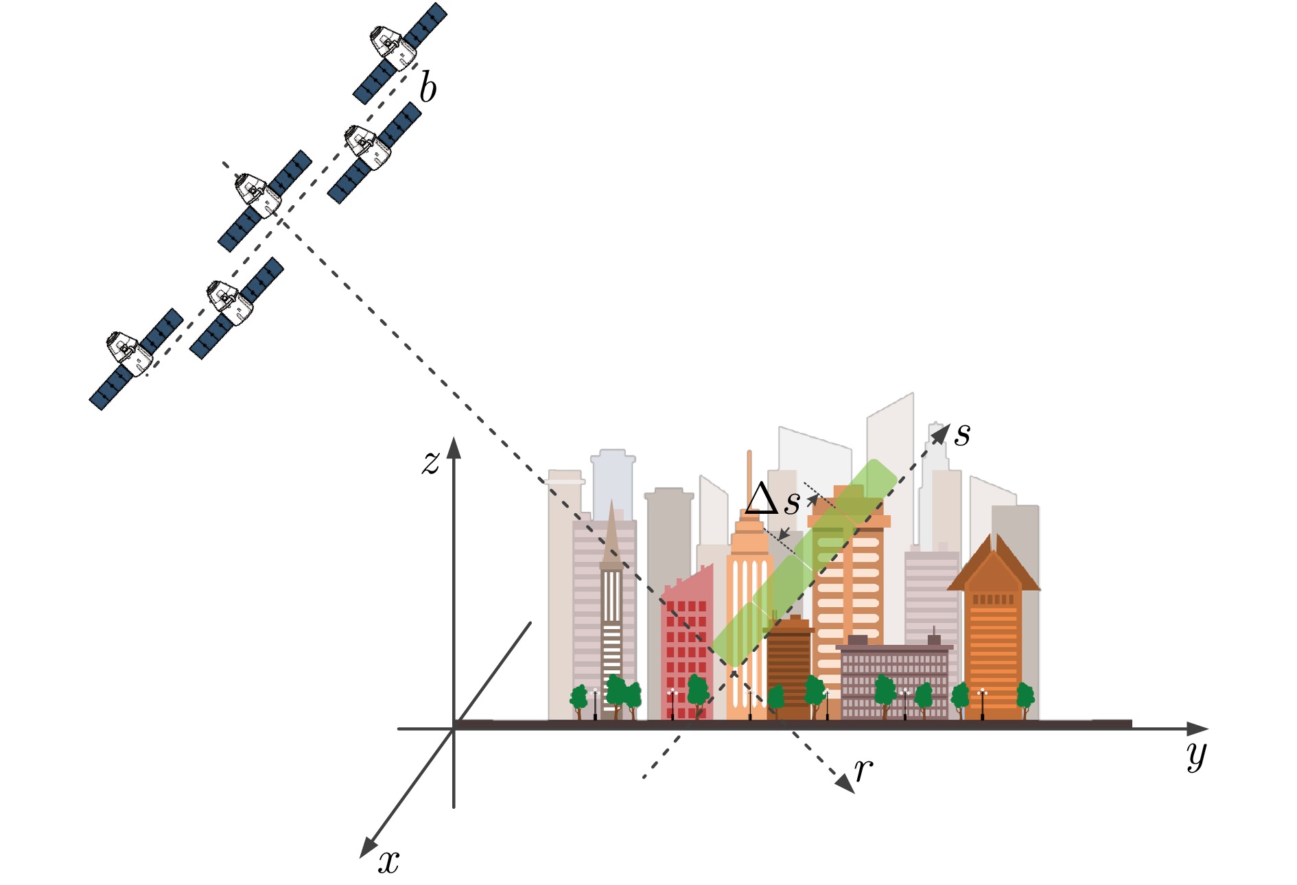
- Figure 1. Schematic of TomoSAR imaging geometry[27]
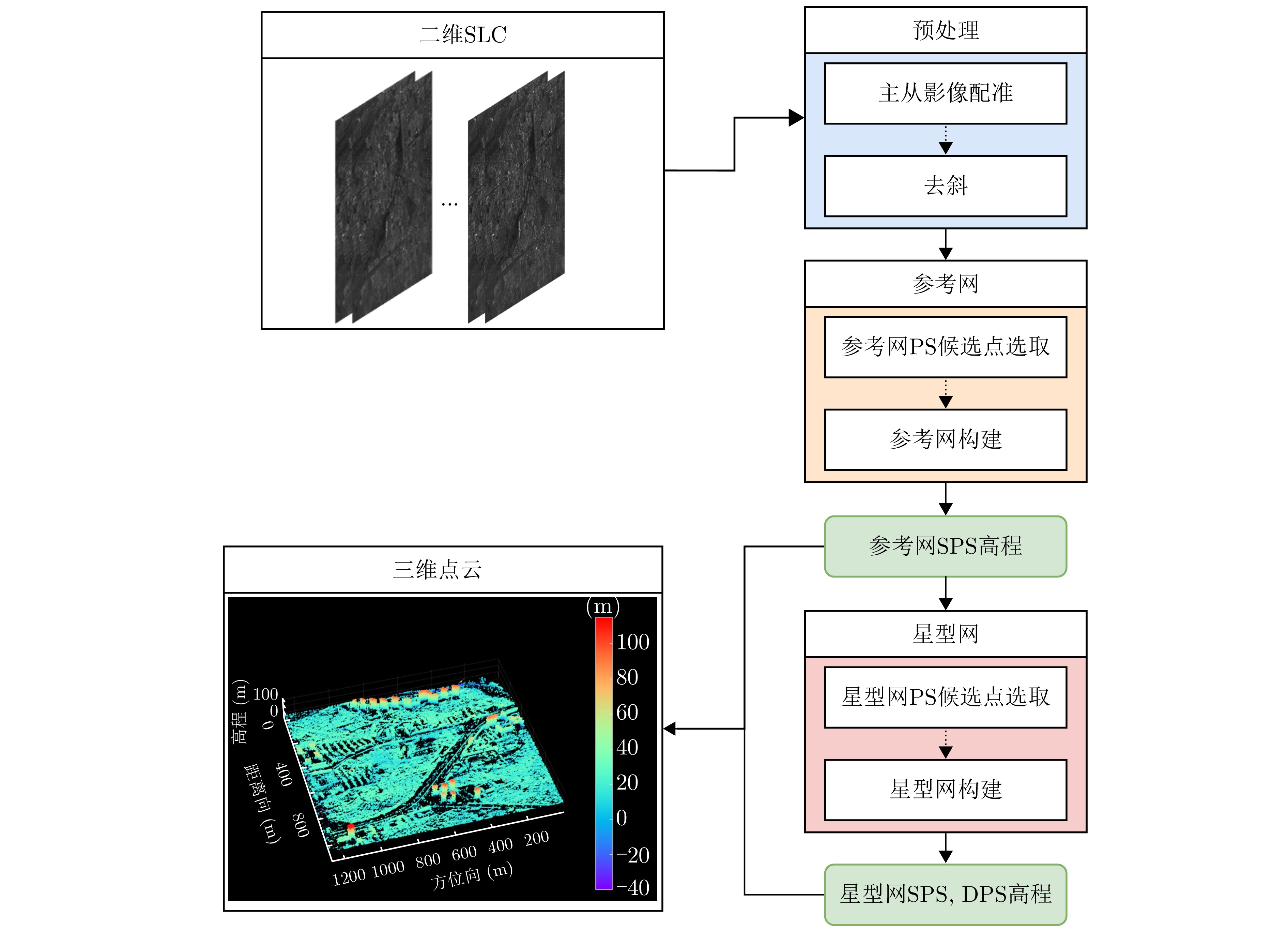
- Figure 2. Framework for TomoSAR 3-D inversion in urban areas
- Figure 3. Overview of Fucheng-1 dataset
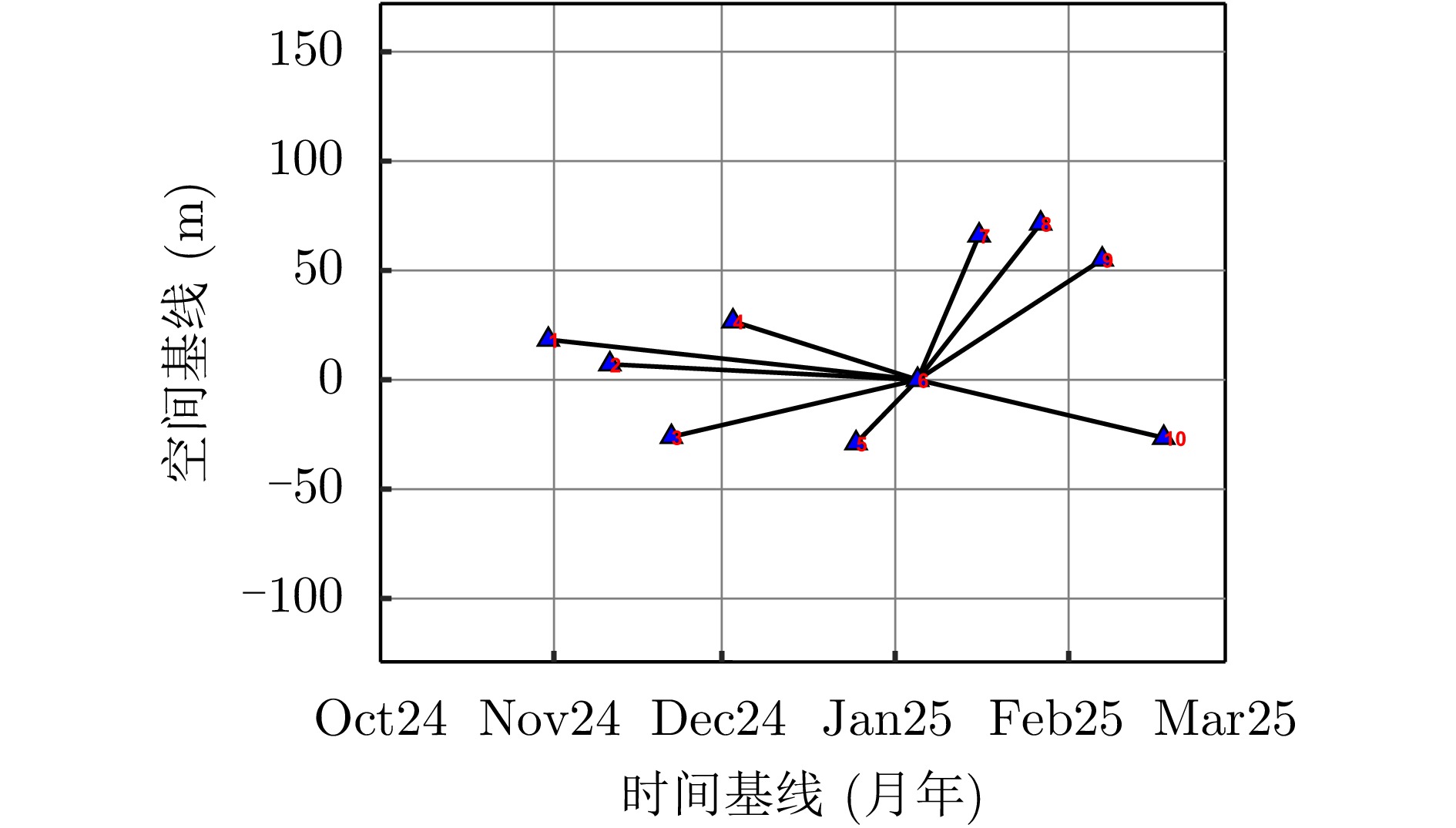
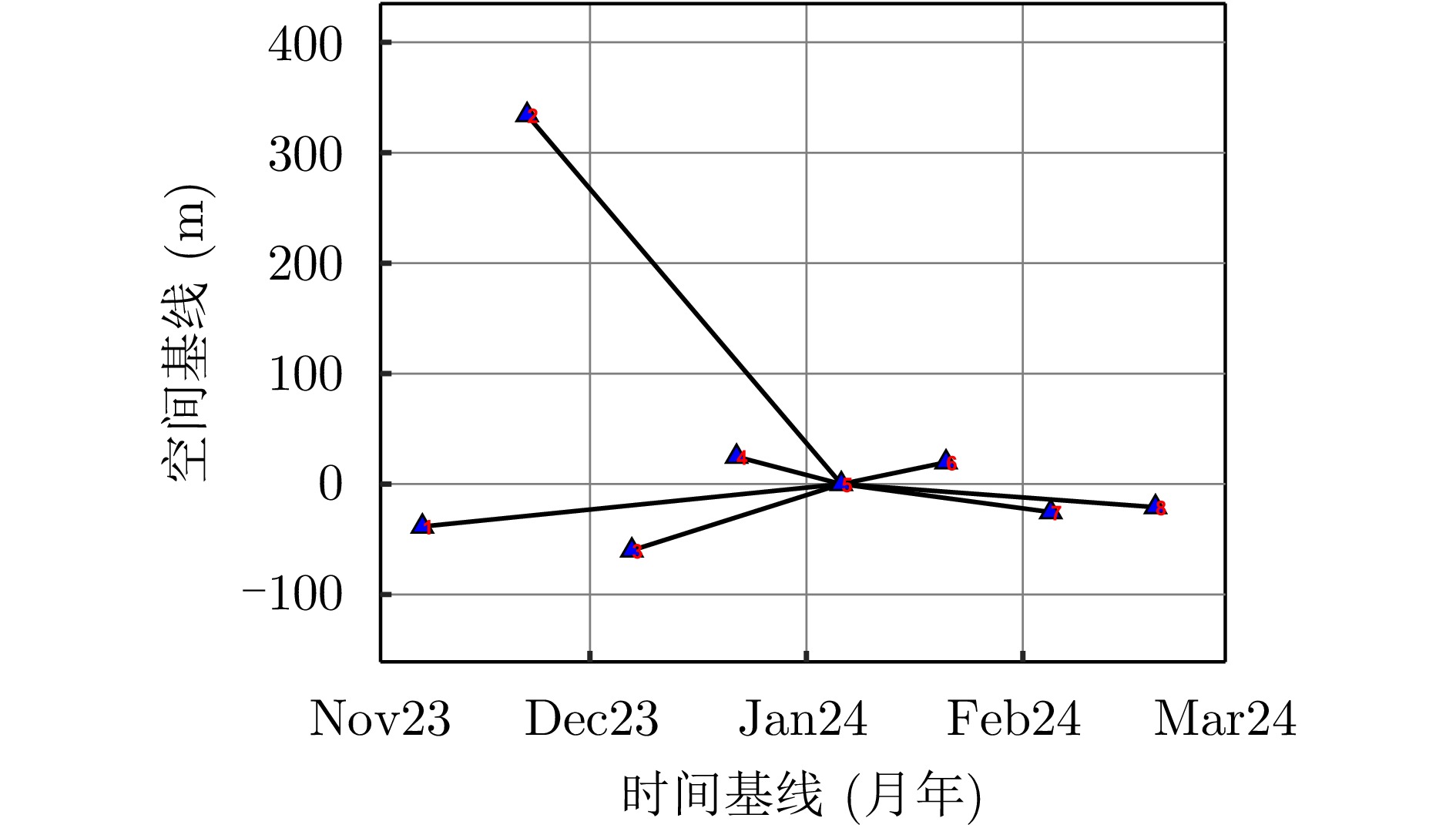
- Figure 4. Spatial-temporal baseline distribution of Fucheng-1 dataset
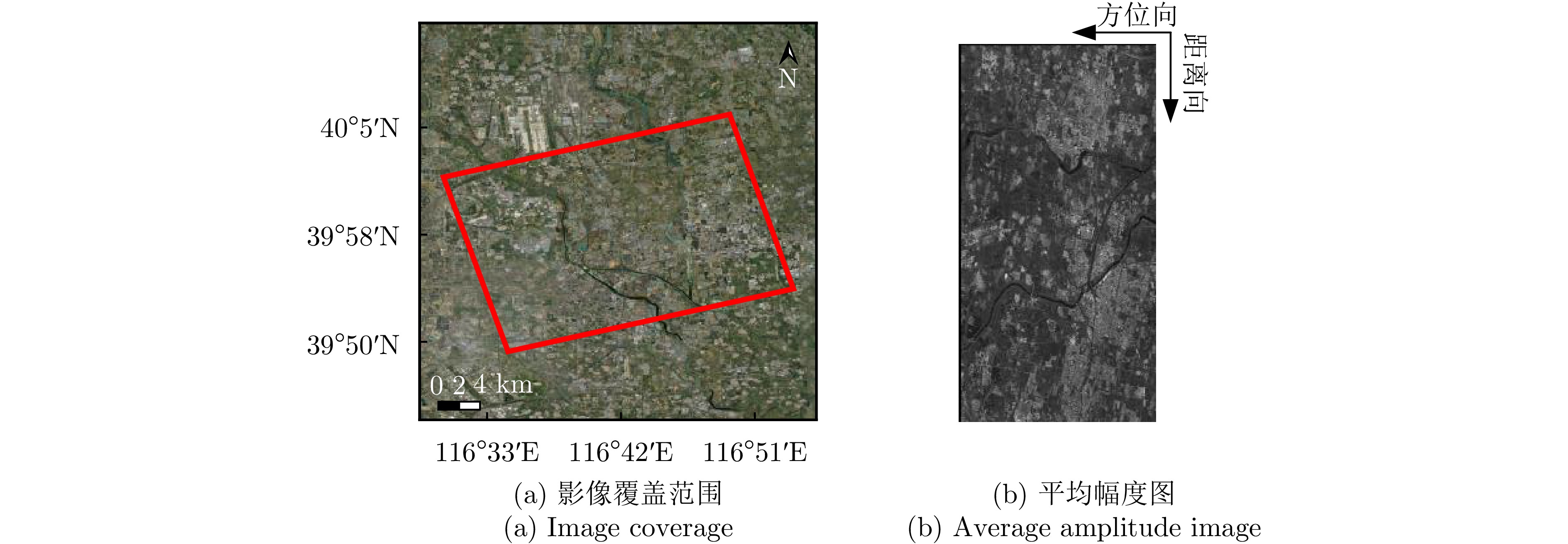
- Figure 5. Overview of Hongtu-1 dataset
- Figure 6. Spatial-temporal baseline distribution of Hongtu-1 dataset
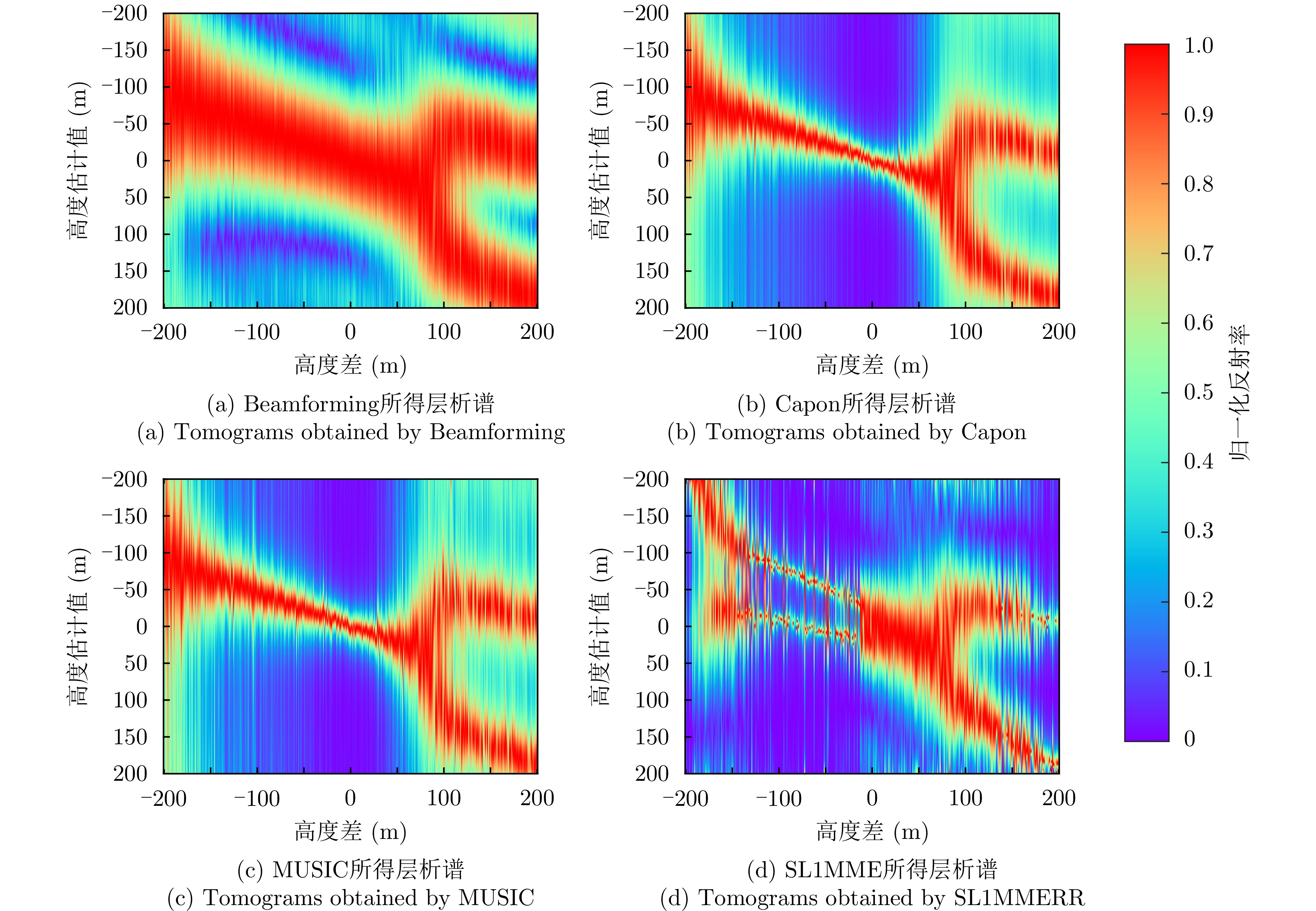
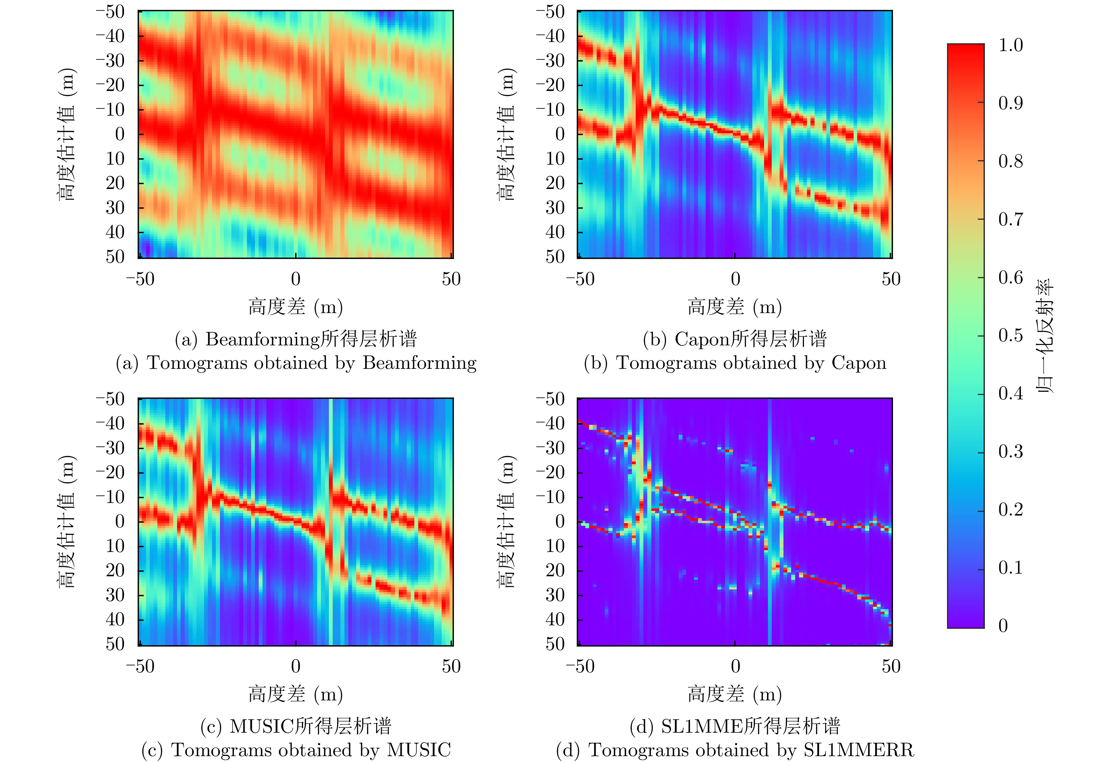
- Figure 7. Tomograms of Fucheng-1 simulation
- Figure 8. Tomograms of Hongtu-1 simulation
- Figure 9. Comparison of inversion results of different methods for the single building of Fucheng-1
- Figure 10. Comparison of inversion results of different methods for the single building of Hongtu-1
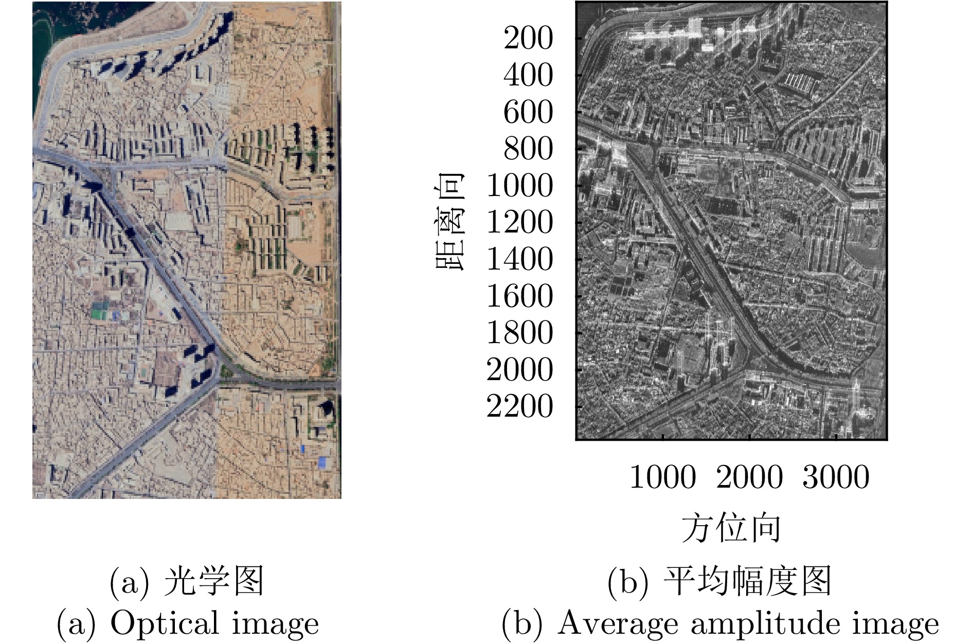
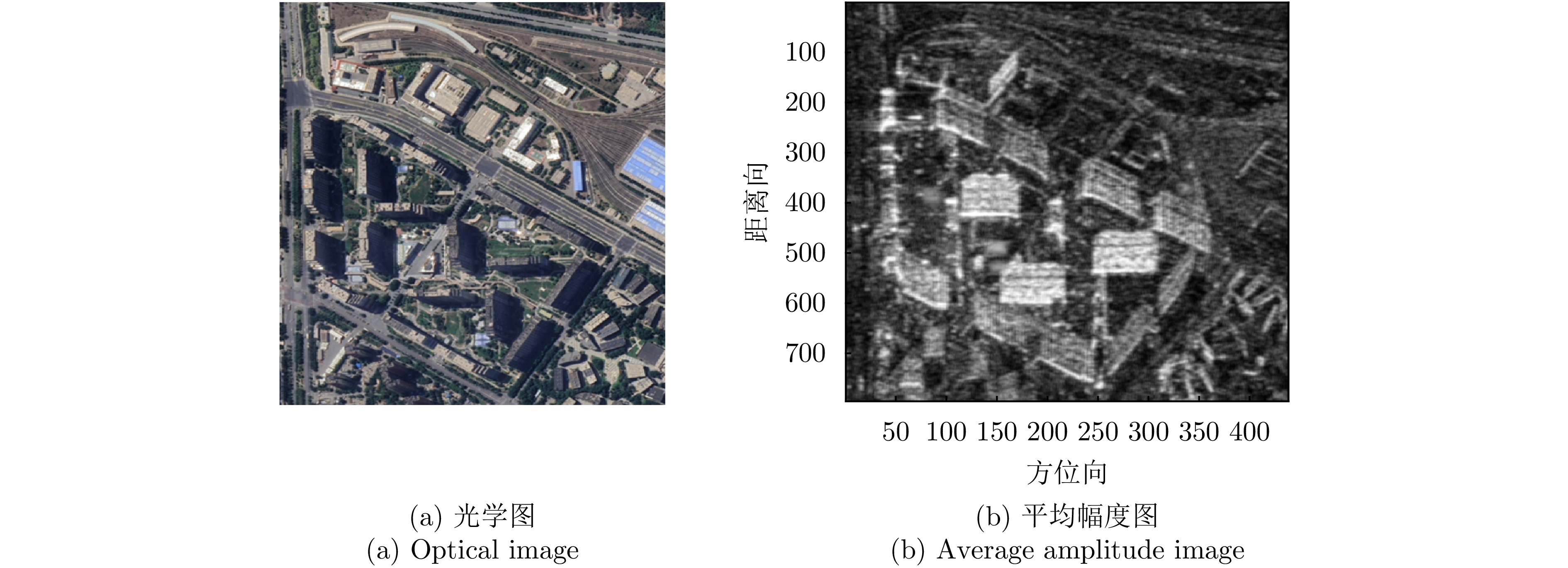
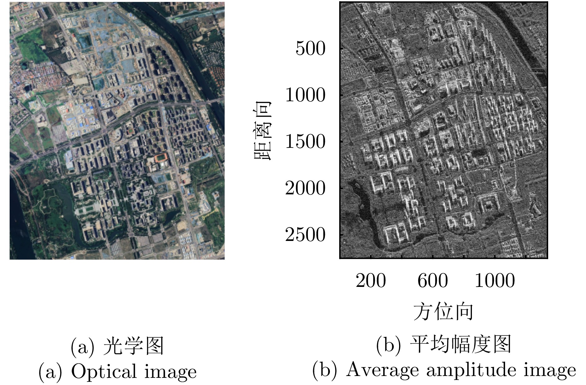
- Figure 11. First scene of Fucheng-1
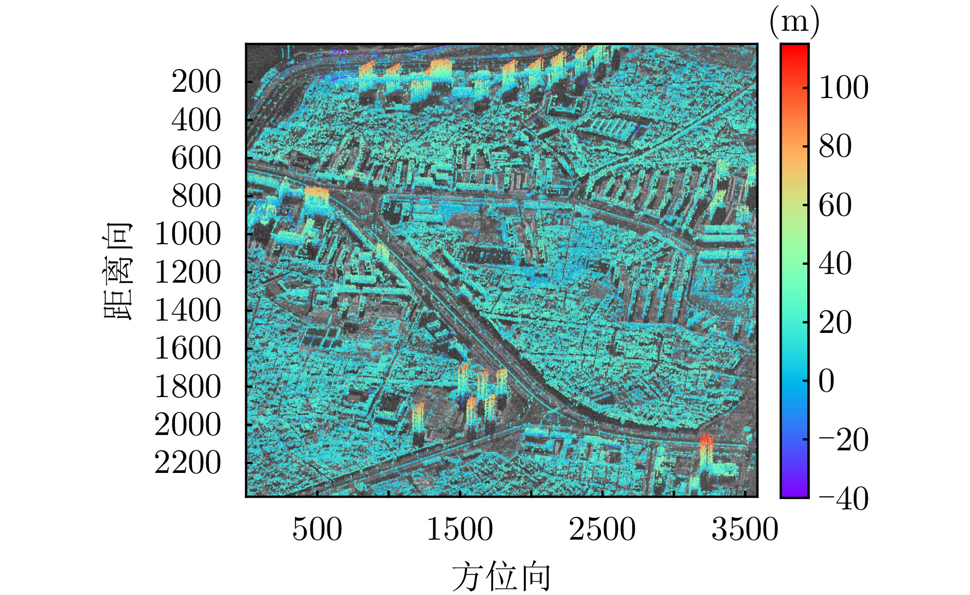
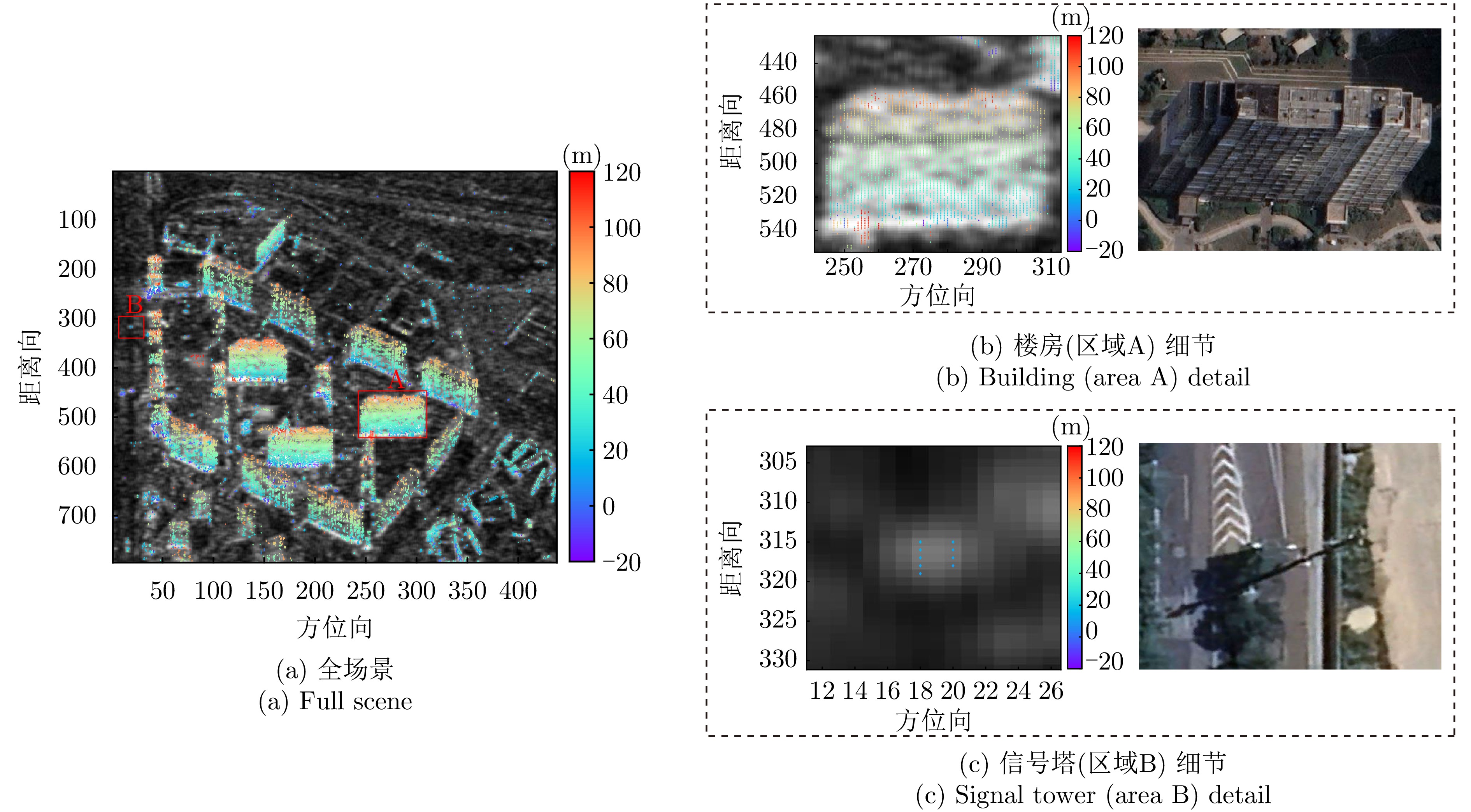
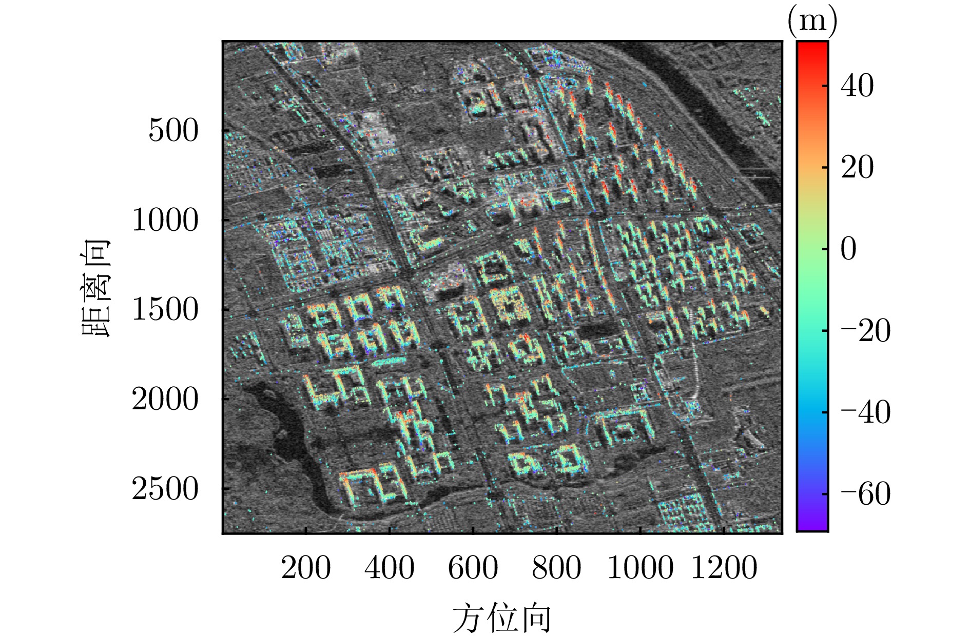
- Figure 12. Height estimation of first scene of Fucheng-1
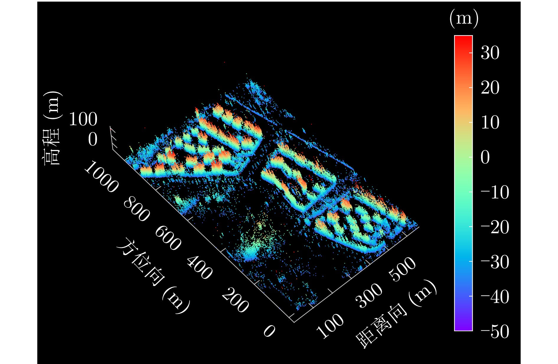
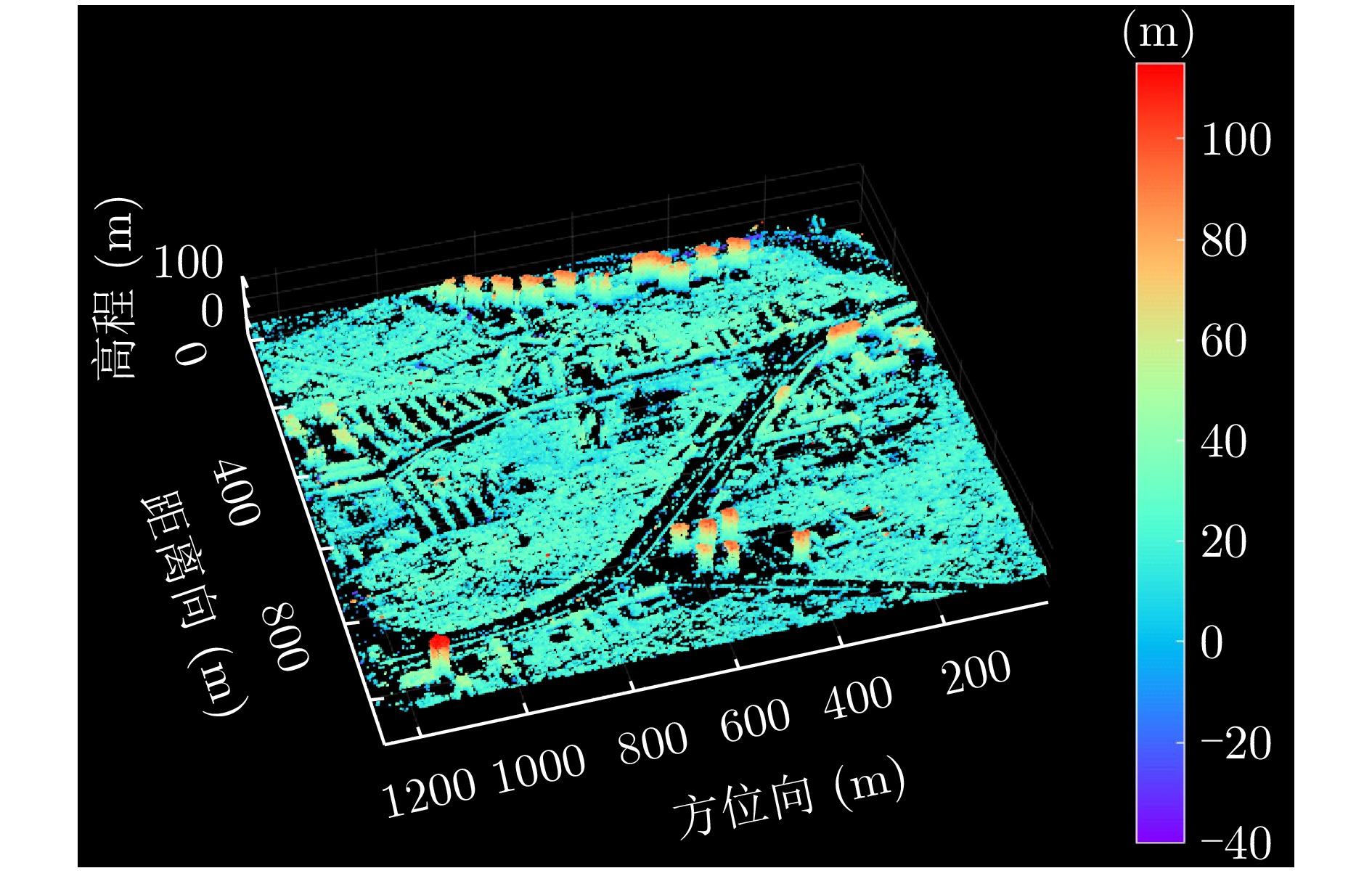
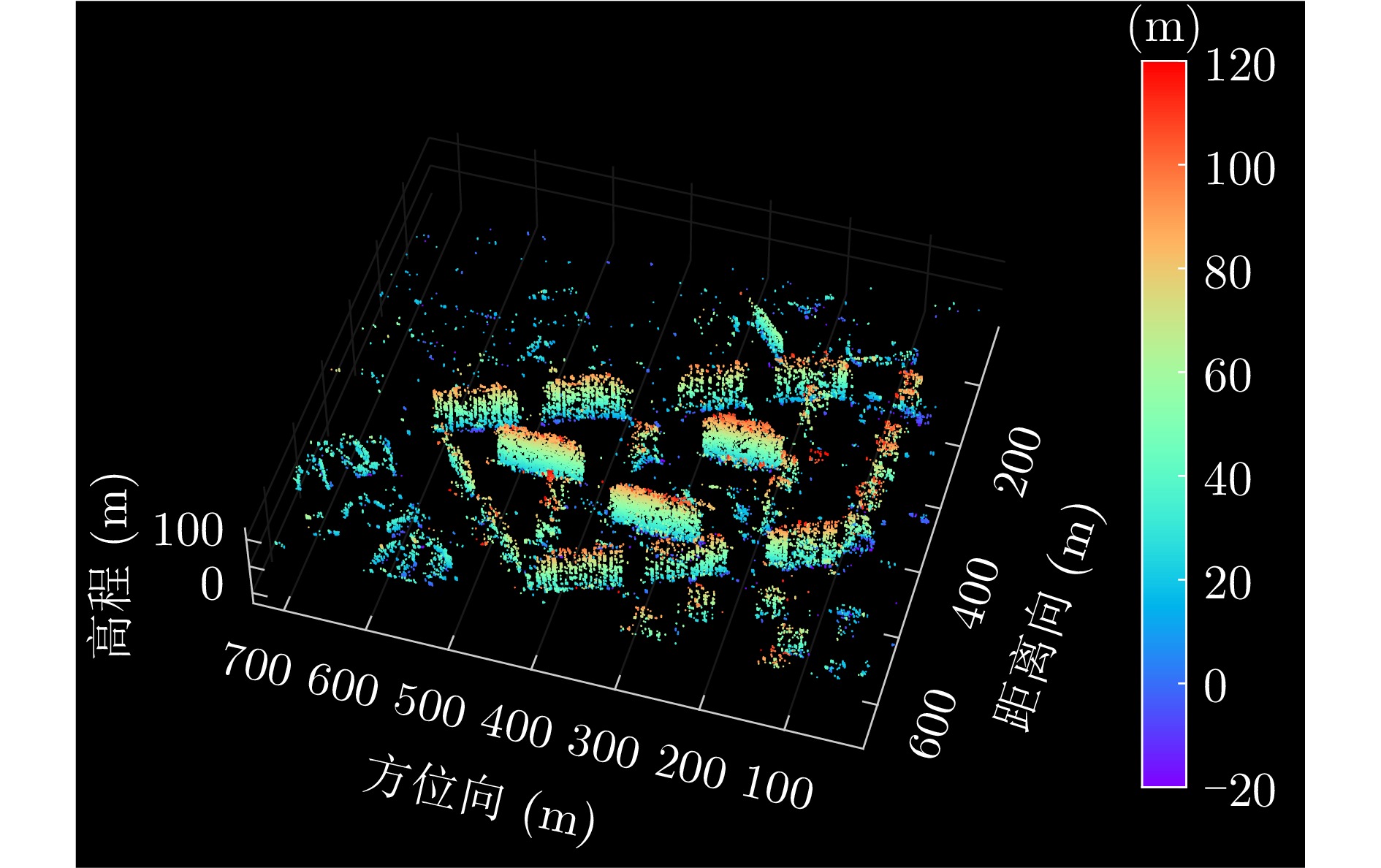
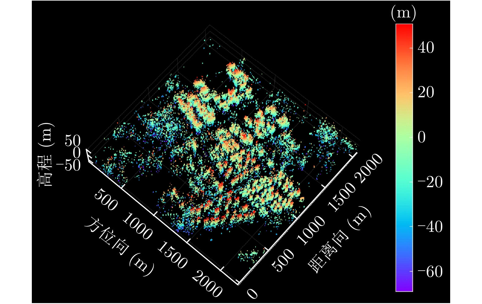
- Figure 13. 3-D point cloud tomographic inversion of first scene of Fucheng-1
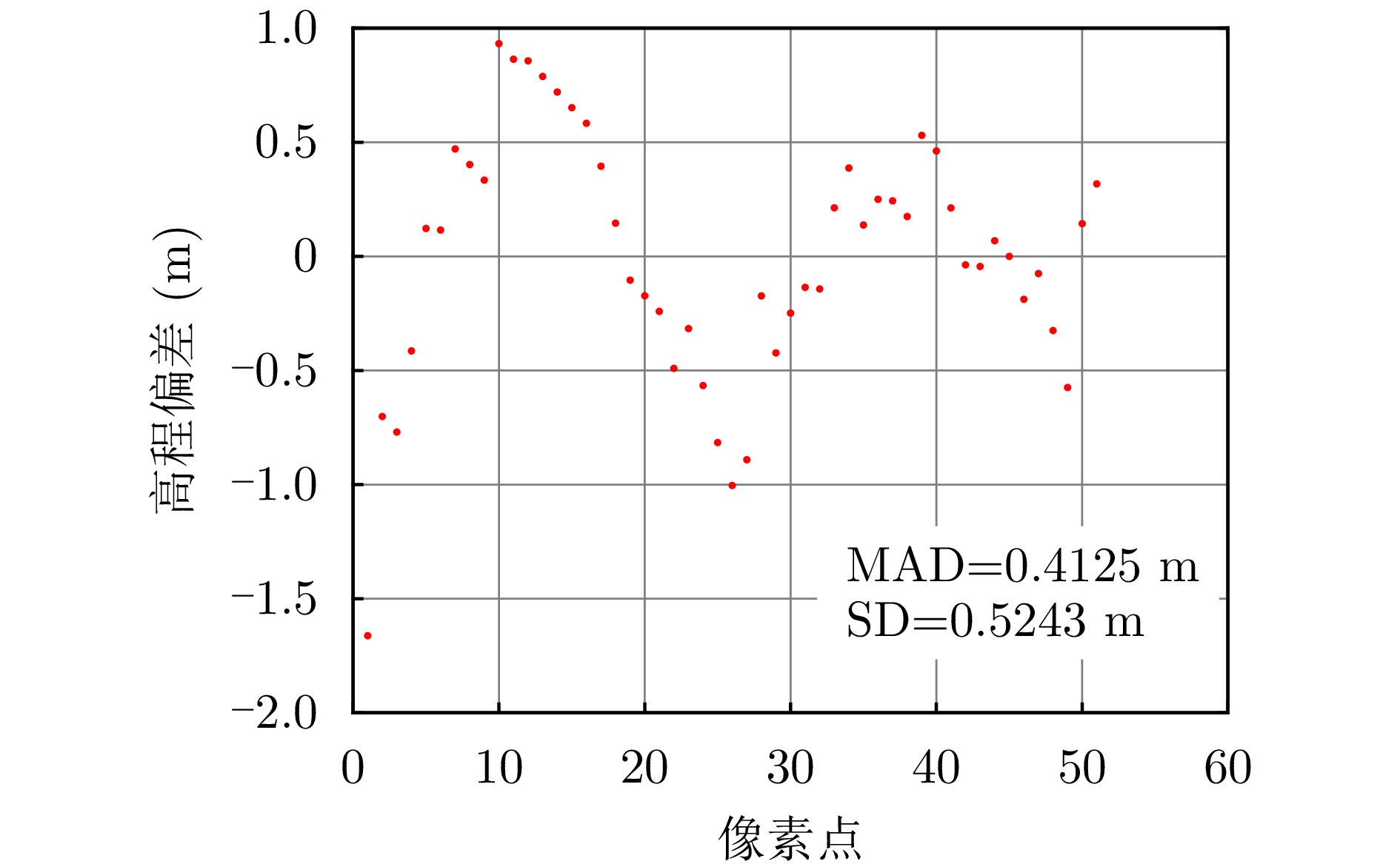
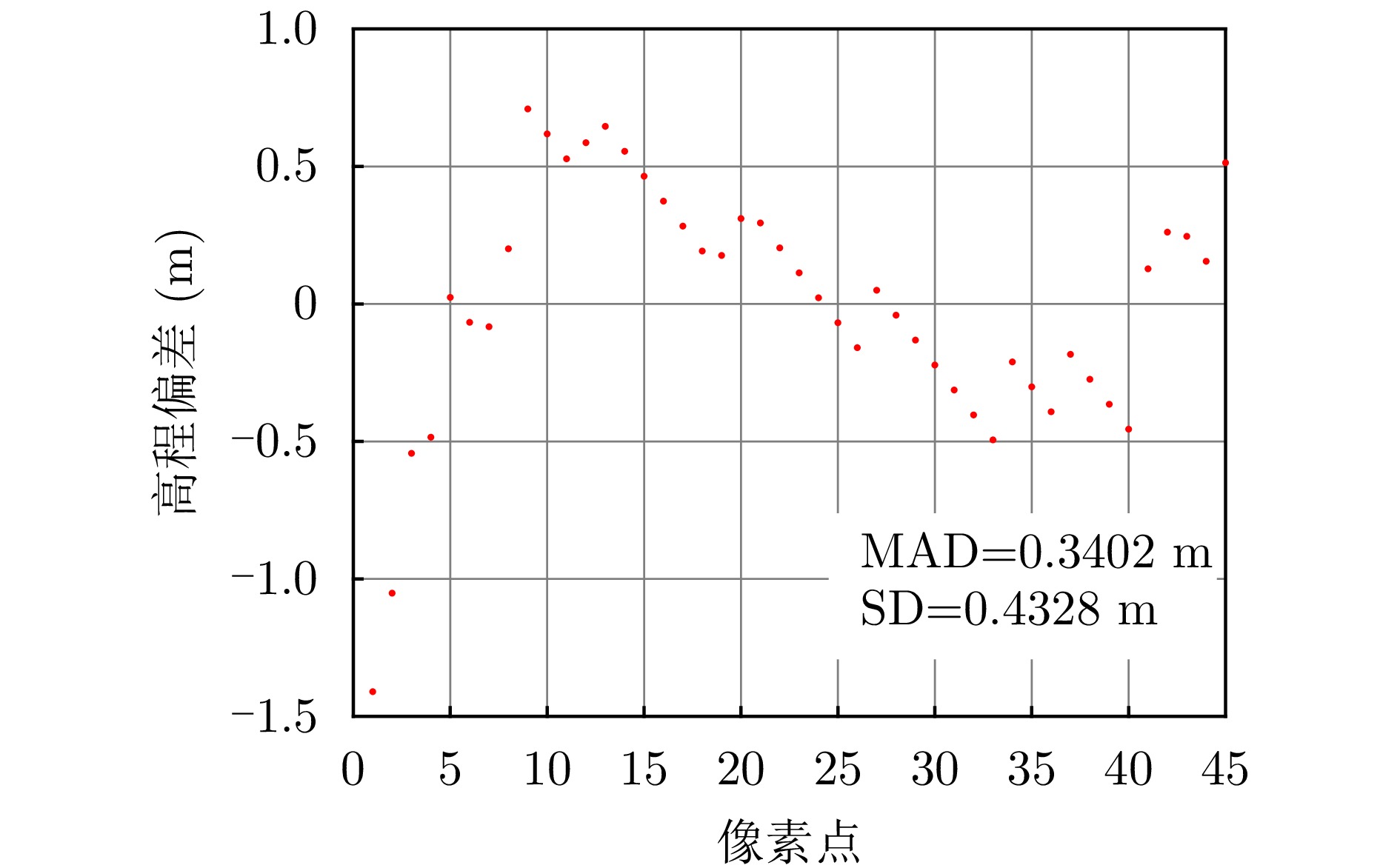
- Figure 14. Height deviation of building horizontal profile of Fucheng-1
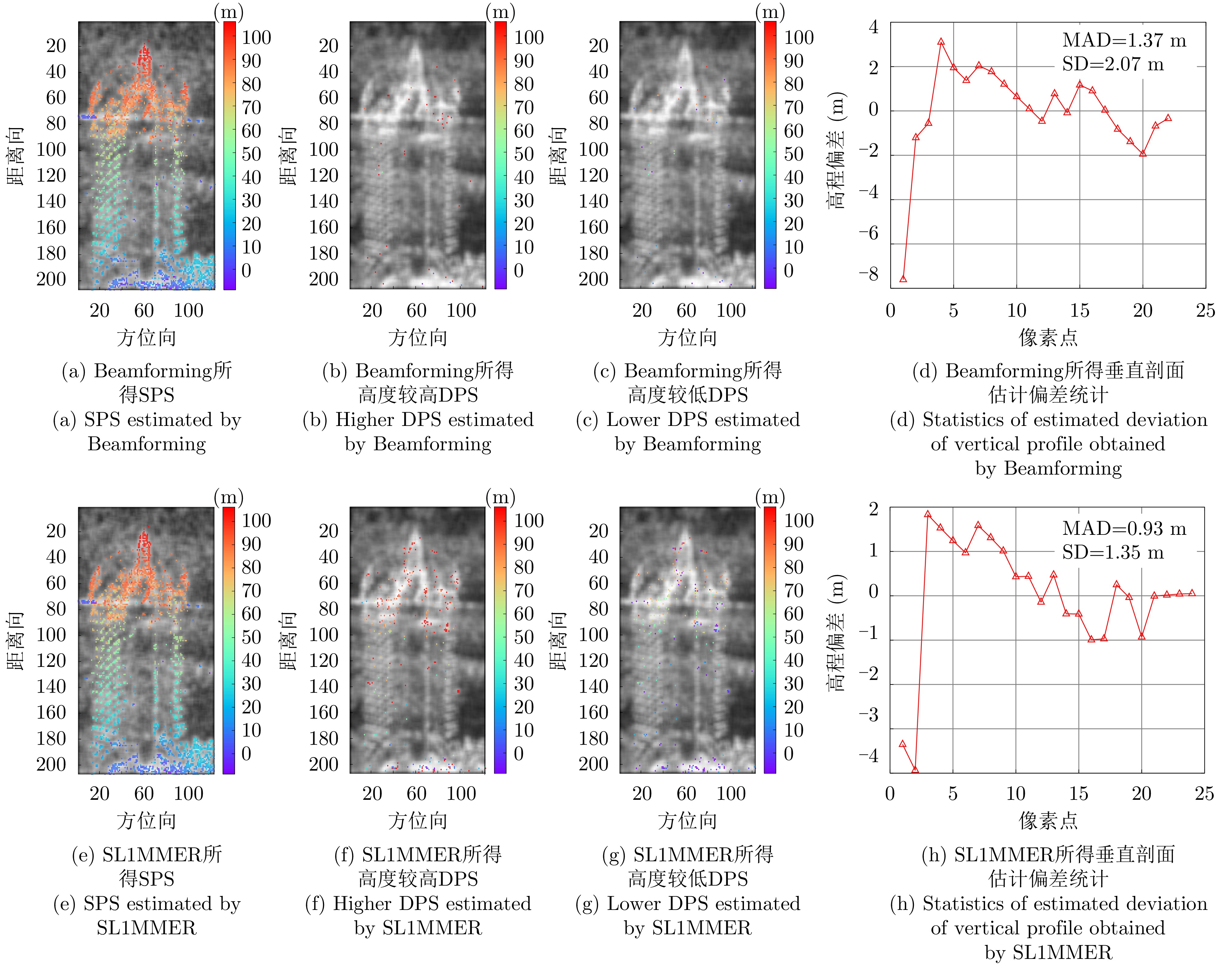
- Figure 15. Second scene of Fucheng-1
- Figure 16. Height estimation of second scene of Fucheng-1
- Figure 17. 3-D point cloud tomographic inversion of second scene of Fucheng-1
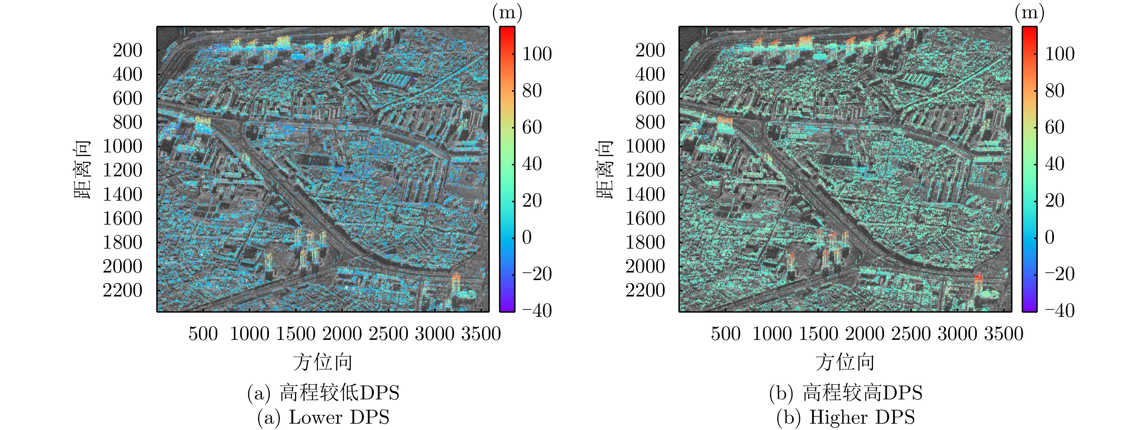
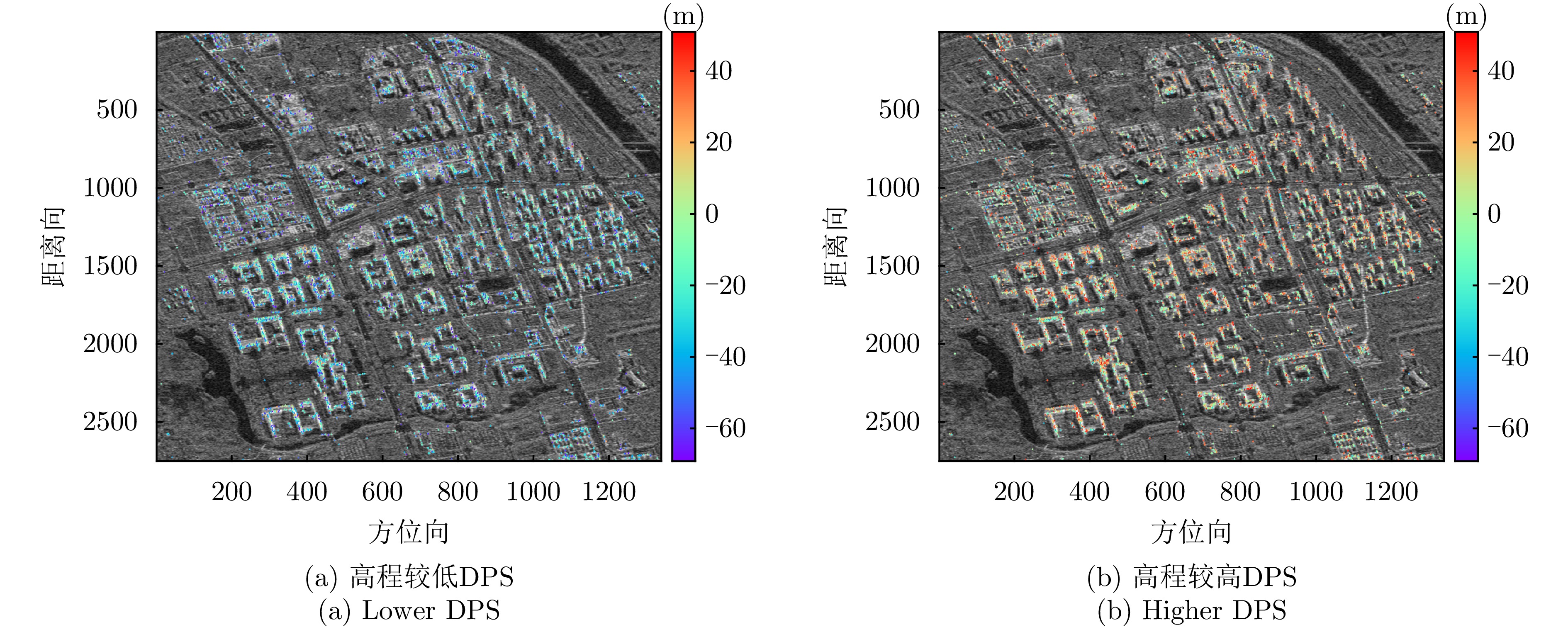
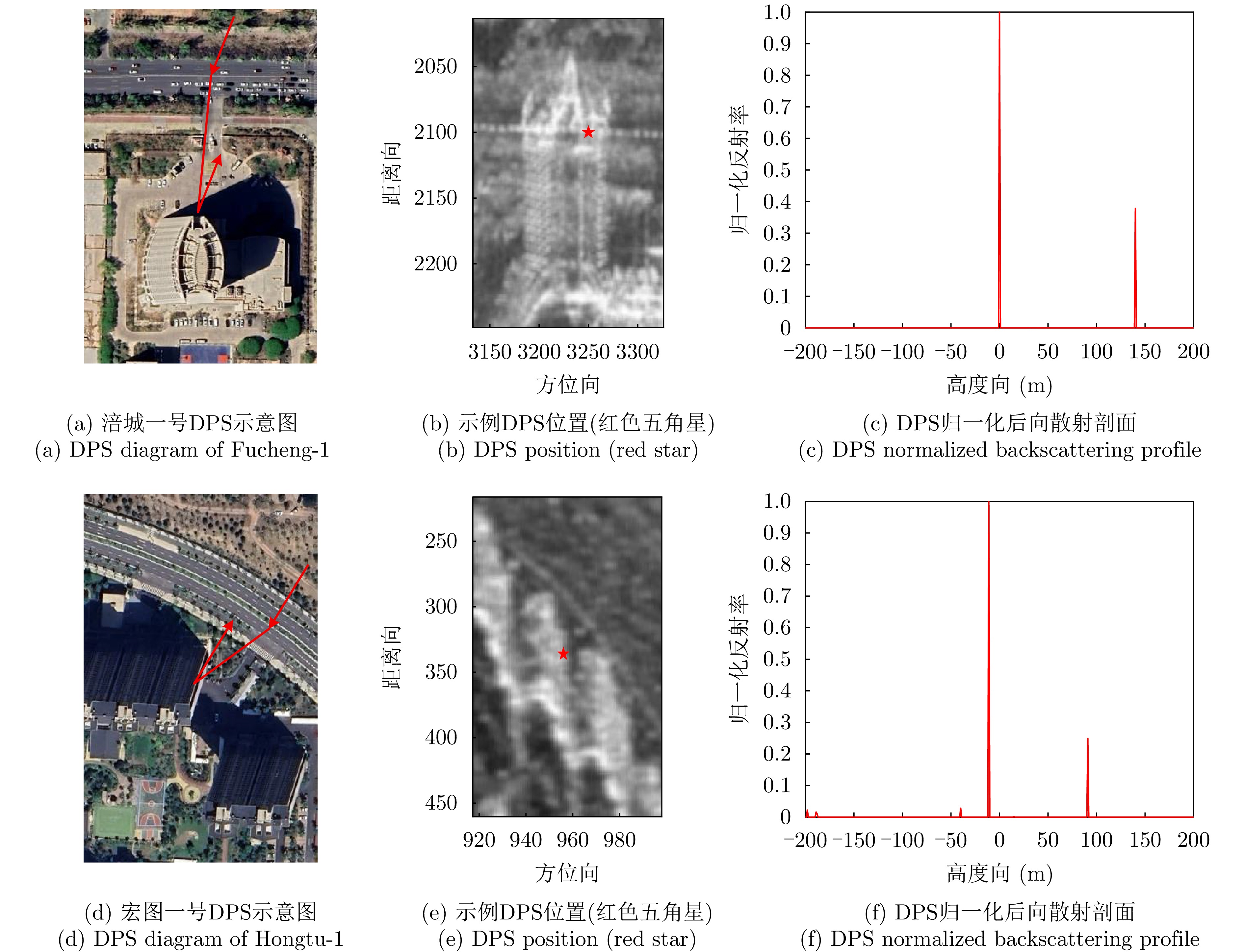
- Figure 18. DPS estimation results of second scene of Fucheng-1
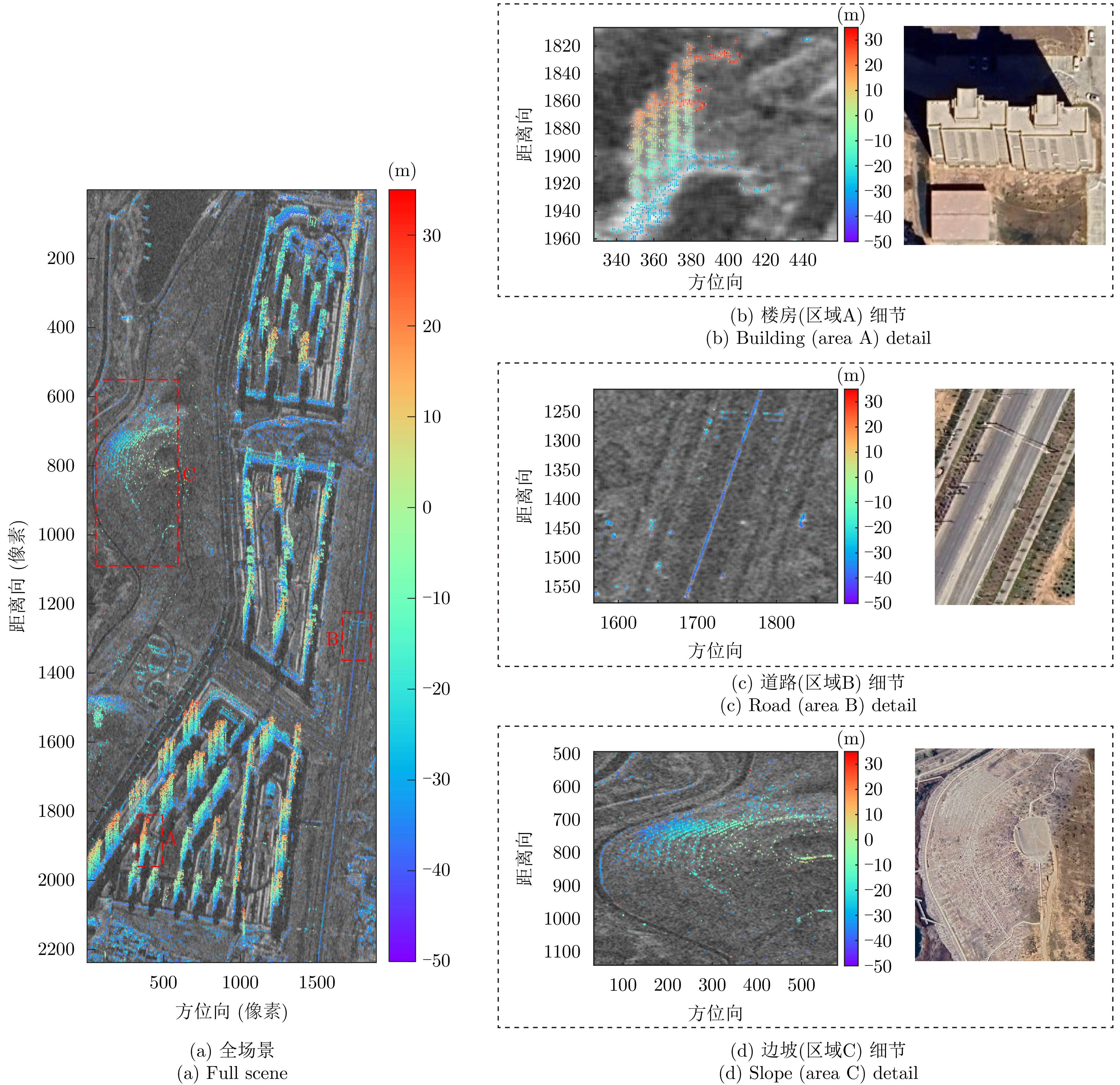
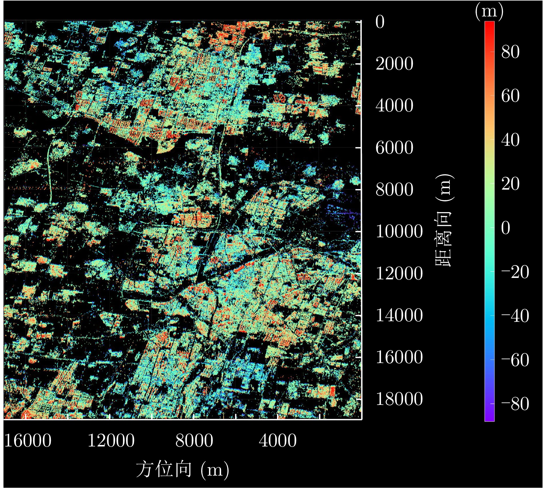
- Figure 19. Full scene height inversion results for the Fucheng-1 Kashi dataset
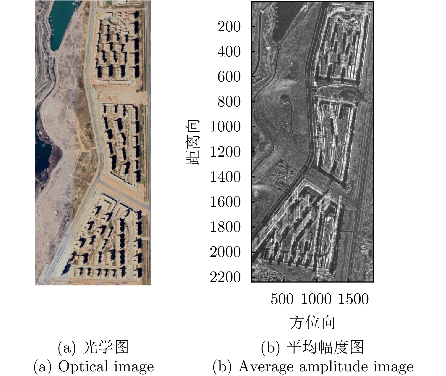
- Figure 20. First scene of Hongtu-1
- Figure 21. Height estimation of first scene of Hongtu-1
- Figure 22. 3-D point cloud tomographic inversion of first scene of Hongtu-1
- Figure 23. Height deviation of building horizontal profile of Hongtu-1
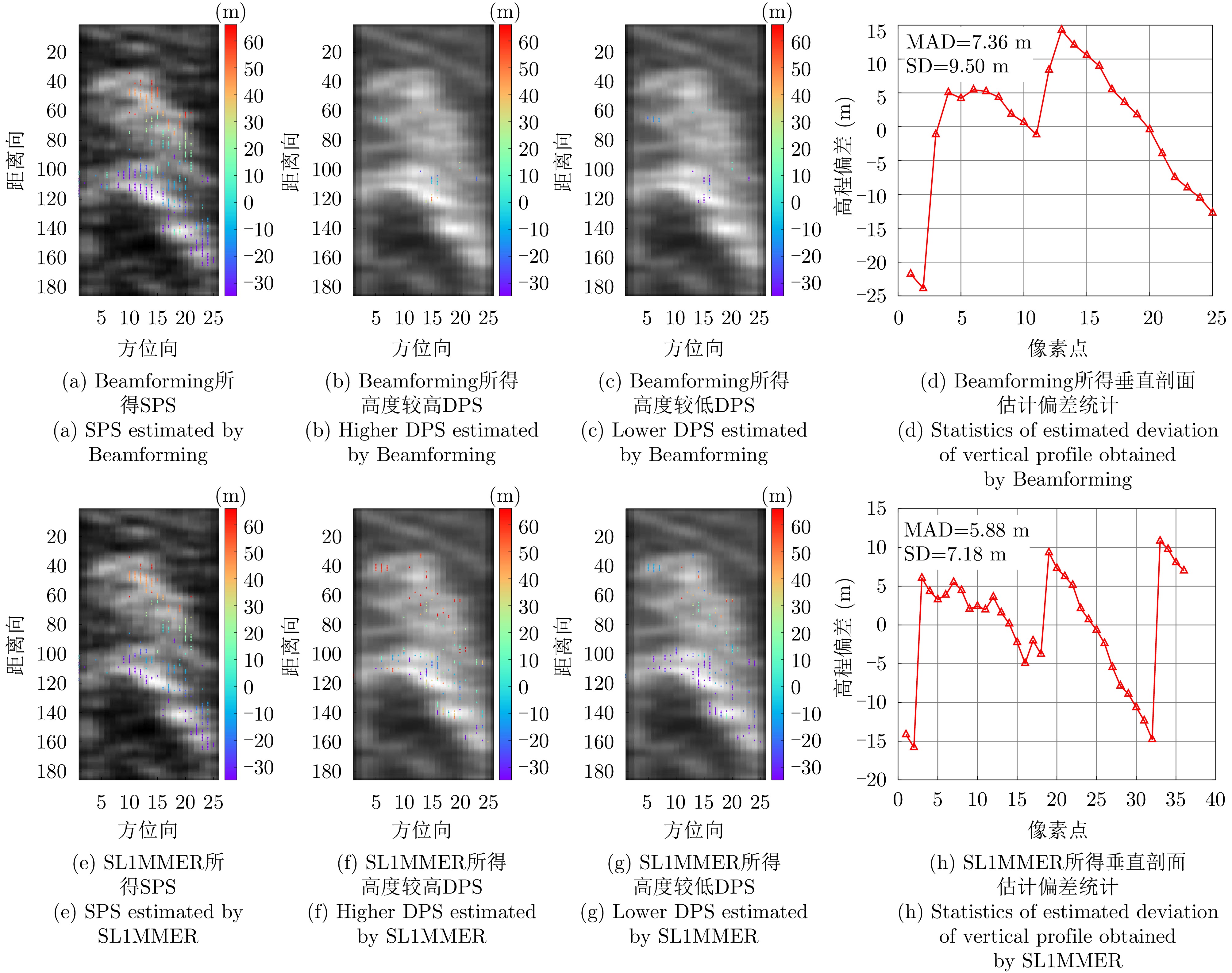
- Figure 24. Second scene of Hongtu-1
- Figure 25. Height estimation of second scene of Hongtu-1
- Figure 26. 3-D point cloud tomographic inversion of second scene of Hongtu-1
- Figure 27. DPS estimation results of second scene of Hongtu-1
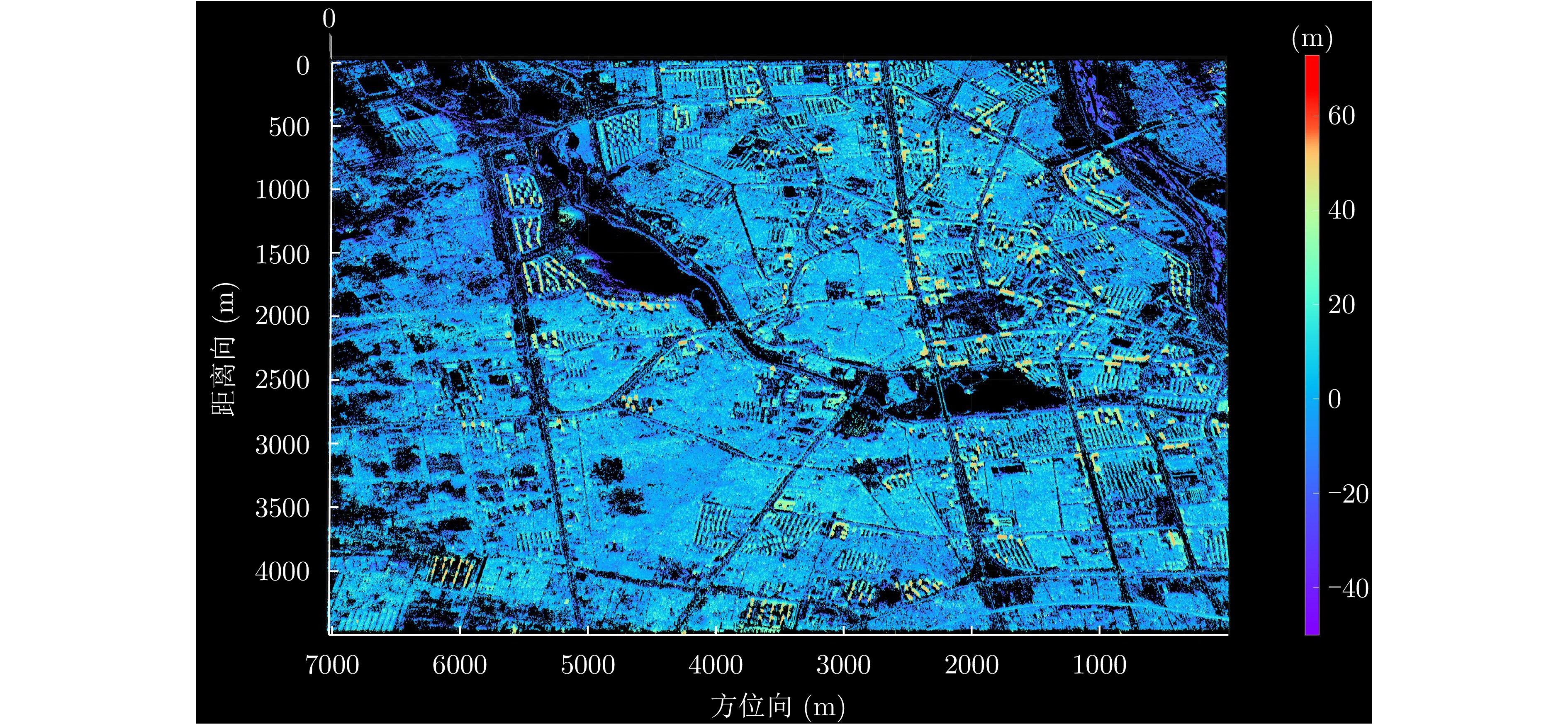
- Figure 28. Full scene height inversion results for the Hongtu-1 Tongzhou dataset
- Figure 29. Layover target analysis