
 Submit Manuscript
 Peer Review
 Editor Work
- Home
- Articles & Issues
-
Data
- Dataset of Radar Detecting Sea
- SAR Dataset
- SARGroundObjectsTypes
- SARMV3D
- AIRSAT Constellation SAR Land Cover Classification Dataset
- 3DRIED
- UWB-HA4D
- LLS-LFMCWR
- FAIR-CSAR
- MSAR
- SDD-SAR
- FUSAR
- SpaceborneSAR3Dimaging
- Sea-land Segmentation
- SAR Multi-domain Ship Detection Dataset
- SAR-Airport
- Hilly and mountainous farmland time-series SAR and ground quadrat dataset
- SAR images for interference detection and suppression
- HP-SAR Evaluation & Analytical Dataset
- GDHuiYan-ATRNet
- Multi-System Maritime Low Observable Target Dataset
- DatasetinthePaper
- DatasetintheCompetition
- Report
- Course
- About
- Publish
- Editorial Board
- Chinese
| Citation: | XU Wenjia, YU Ruiqing, XUE Minghao, et al. A survey on earth observation multimodal large language models: Framework, core technologies, and future perspectives[J]. Journal of Radars, 2026, 15(1): 361–386. doi: 10.12000/JR25088

|
A Survey on Earth Observation Multimodal Large Language Models: Framework, Core Technologies, and Future Perspectives
DOI: 10.12000/JR25088 CSTR: 32380.14.JR25088
More Information-
Abstract
In recent years, the rapid development of Multimodal Large Language Models (MLLMs) and their applications in earth observation have garnered significant attention. Earth observation MLLMs achieve deep integration of multimodal information, including optical imagery, Synthetic Aperture Radar (SAR) imagery, and textual data, through the design of bridging mechanisms between large language models and vision models, combined with joint training strategies. This integration facilitates a paradigm shift in intelligent earth observation interpretation—from shallow semantic matching to higher-level understanding based on world knowledge. In this study, we systematically review the research progress in the applications of MLLMs in earth observation, specifically examining the development of Earth Observation MLLMs (EO-MLLMs), which provides a foundation for future research directions. Initially, we discuss the concept of EO-MLLMs and review their development in chronological order. Subsequently, we provide a detailed analysis and statistical summary of the proposed architectures, training methods, applications, and corresponding benchmark datasets, along with an introduction to Earth Observation Agents (EO-Agent). Finally, we summarize the research status of EO-MLLMs and discuss future research directions. -

-
References
[1] 王桥, 刘思含. 国家环境遥感监测体系研究与实现[J]. 遥感学报, 2016, 20(5): 1161–1169. doi: 10.11834/jrs.20166201.WANG Qiao and LIU Sihan. Research and implementation of national environmental remote sensing monitoring system[J]. Journal of Remote Sensing, 2016, 20(5): 1161–1169. doi: 10.11834/jrs.20166201.[2] 安立强, 张景发, MONTEIRO R, 等. 地震灾害损失评估与遥感技术现状和展望[J]. 遥感学报, 2024, 28(4): 860–884. doi: 10.11834/jrs.20232093.AN Liqiang, ZHANG Jingfa, MONTEIRO R, et al. A review and prospective research of earthquake damage assessment and remote sensing[J]. National Remote Sensing Bulletin, 2024, 28(4): 860–884. doi: 10.11834/jrs.20232093.[3] 张王菲, 陈尔学, 李增元, 等. 雷达遥感农业应用综述[J]. 雷达学报, 2020, 9(3): 444–461. doi: 10.12000/JR20051.ZHANG Wangfei, CHEN Erxue, LI Zengyuan, et al. Review of applications of radar remote sensing in agriculture[J]. Journal of Radars, 2020, 9(3): 444–461. doi: 10.12000/JR20051.[4] LI Yansheng, DANG Bo, ZHANG Yongjun, et al. Water body classification from high-resolution optical remote sensing imagery: Achievements and perspectives[J]. ISPRS Journal of Photogrammetry and Remote Sensing, 2022, 187: 306–327. doi: 10.1016/j.isprsjprs.2022.03.013.[5] LI Yansheng, WEI Fanyi, ZHANG Yongjun, et al. HS2P: Hierarchical spectral and structure-preserving fusion network for multimodal remote sensing image cloud and shadow removal[J]. Information Fusion, 2023, 94: 215–228. doi: 10.1016/j.inffus.2023.02.002.[6] CHEN Yongqi, FENG Shou, ZHAO Chunhui, et al. High-resolution remote sensing image change detection based on Fourier feature interaction and multiscale perception[J]. IEEE Transactions on Geoscience and Remote Sensing, 2024, 62: 5539115. doi: 10.1109/TGRS.2024.3500073.[7] 杨桄, 刘湘南. 遥感影像解译的研究现状和发展趋势[J]. 国土资源遥感, 2004(2): 7–10, 15. doi: 10.3969/j.issn.1001-070X.2004.02.002.YANG Guang and LIU Xiangnan. The present research condition and development trend of remotely sensed imagery interpretation[J]. Remote Sensing for Land & Resources, 2004(2): 7–10, 15. doi: 10.3969/j.issn.1001-070X.2004.02.002.[8] ZHAO W X, ZHOU Kun, LI Junyi, et al. A survey of large language models[J]. arXiv preprint arXiv: 2303.18223, 2023. doi: 10.48550/arXiv.2303.18223.[9] YIN Shukang, FU Chaoyou, ZHAO Sirui, et al. A survey on multimodal large language models[J]. National Science Review, 2024, 11(12): nwae403. doi: 10.1093/nsr/nwae403.[10] HU Yuan, YUAN Jianlong, WEN Congcong, et al. RSGPT: A remote sensing vision language model and benchmark[J]. ISPRS Journal of Photogrammetry and Remote Sensing, 2025, 224: 272–286. doi: 10.1016/j.isprsjprs.2025.03.028.[11] MUHTAR D, LI Zhenshi, GU Feng, et al. LHRS-Bot: Empowering remote sensing with VGI-enhanced large multimodal language model[C]. The 18th European Conference on Computer Vision, Milan, Italy, 2024: 440–457. doi: 10.1007/978-3-031-72904-1_26.[12] ZHANG Wei, CAI Miaoxin, ZHANG Tong, et al. EarthGPT: A universal multimodal large language model for multisensor image comprehension in remote sensing domain[J]. IEEE Transactions on Geoscience and Remote Sensing, 2024, 62: 5917820. doi: 10.1109/TGRS.2024.3409624.[13] LI Yujie, XU Wenjia, LI Guangzuo, et al. UniRS: Unifying multi-temporal remote sensing tasks through vision language models[J]. arXiv preprint arXiv: 2412.20742, 2024. doi: 10.48550/arXiv.2412.20742.[14] VOUTILAINEN A. A syntax-based part-of-speech analyser[C]. The 7th Conference of the European Chapter of the Association for Computational Linguistics, Dublin, Ireland, 1995.[15] BRILL E and RESNIK P. A rule-based approach to prepositional phrase attachment disambiguation[C]. The 15th International Conference on Computational Linguistics, Kyoto, Japan, 1994.[16] HINTON G E, OSINDERO S, and TEH Y W. A fast learning algorithm for deep belief nets[J]. Neural Computation, 2006, 18(7): 1527–1554. doi: 10.1162/neco.2006.18.7.1527.[17] DEVLIN J, CHANG M W, LEE K, et al. BERT: Pre-training of deep bidirectional transformers for language understanding[C]. 2019 Conference of the North American Chapter of the Association for Computational Linguistics: Human Language Technologies, Volume 1 (Long and Short Papers), Minneapolis, Minnesota, 2019: 4171–4186. doi: 10.18653/v1/N19-1423.[18] RADFORD A, NARASIMHAN K, SALIMANS T, et al. Improving language understanding by generative pre-training[EB/OL]. https://openai.com/iadex/language-unsupervised, 2018.[19] RADFORD A, WU J, CHILD R, et al. Language models are unsupervised multitask learners[EB/OL]. https://openai.com/index/better-langaage-models/, 2019.[20] BROWN T, MANN B, RYDER N, et al. Language models are few-shot learners[C]. The 34th International Conference on Neural Information Processing Systems, Vancouver, Canada, 2020: 159.[21] OpenAI. GPT-4 technical report[J]. arXiv preprint arXiv: 2303.08774, 2023. doi: 10.48550/arXiv.2303.08774.[22] TOUVRON H, LAVRIL T, IZACARD G, et al. LLaMA: Open and efficient foundation language models[J]. arXiv preprint arXiv: 2302.13971, 2023. doi: 10.48550/arXiv.2302.13971.[23] BAI Jinze, BAI Shuai, CHU Yunfei, et al. Qwen technical report[J]. arXiv preprint arXiv: 2309.16609, 2023. doi: 10.48550/arXiv.2309.16609.[24] DeepSeek-AI. DeepSeek-V3 technical report[J]. arXiv preprint arXiv: 2412.19437, 2024. doi: 10.48550/arXiv.2412.19437.[25] VASWANI A, SHAZEER N, PARMAR N, et al. Attention is all you need[C]. The 31st International Conference on Neural Information Processing Systems, Long Beach, USA, 2017: 6000–6010.[26] LIU Haotian, LI Chunyuan, WU Qingyang, et al. Visual instruction tuning[C]. The 37th International Conference on Neural Information Processing Systems, New Orleans, USA, 2023: 1516.[27] LIN Bin, YE Yang, ZHU Bin, et al. Video-LLaVA: Learning united visual representation by alignment before projection[C]. 2024 Conference on Empirical Methods in Natural Language Processing, Miami, USA, 2024: 5971–5984.[28] KOH J Y, FRIED D, and SALAKHUTDINOV R R. Generating images with multimodal language models[C]. The 37th International Conference on Neural Information Processing Systems, New Orleans, USA, 2023: 939.[29] ZHOU Yue, LAN Mengcheng, LI Xiang, et al. GeoGround: A unified large vision-language model for remote sensing visual grounding[J]. arXiv preprint arXiv: 2411.11904, 2024. doi: 10.48550/arXiv.2411.11904.[30] WANG Peijin, HU Huiyang, TONG Boyuan, et al. RingMoGPT: A unified remote sensing foundation model for vision, language, and grounded tasks[J]. IEEE Transactions on Geoscience and Remote Sensing, 2025, 63: 5611320. doi: 10.1109/TGRS.2024.3510833.[31] ZHAN Yang, XIONG Zhitong, and YUAN Yuan. SkyEyeGPT: Unifying remote sensing vision-language tasks via instruction tuning with large language model[J]. ISPRS Journal of Photogrammetry and Remote Sensing, 2025, 221: 64–77. doi: 10.1016/j.isprsjprs.2025.01.020.[32] 张永军, 李彦胜, 党博, 等. 多模态遥感基础大模型: 研究现状与未来展望[J]. 测绘学报, 2024, 53(10): 1942–1954. doi: 10.11947/j.AGCS.2024.20240019.ZHANG Yongjun, LI Yansheng, DANG Bo, et al. Multi-modal remote sensing large foundation models: Current research status and future prospect[J]. Acta Geodaetica et Cartographica Sinica, 2024, 53(10): 1942–1954. doi: 10.11947/j.AGCS.2024.20240019.[33] HONG Danfeng, HAN Zhu, YAO Jing, et al. SpectralFormer: Rethinking hyperspectral image classification with transformers[J]. IEEE Transactions on Geoscience and Remote Sensing, 2022, 60: 5518615. doi: 10.1109/TGRS.2021.3130716.[34] HONG Danfeng, ZHANG Bing, LI Xuyang, et al. SpectralGPT: Spectral remote sensing foundation model[J]. IEEE Transactions on Pattern Analysis and Machine Intelligence, 2024, 46(8): 5227–5244. doi: 10.1109/TPAMI.2024.3362475.[35] FULLER A, MILLARD K, and GREEN J R. CROMA: Remote sensing representations with contrastive radar-optical masked autoencoders[C]. The 37th International Conference on Neural Information Processing Systems, New Orleans, USA, 2023: 241.[36] WANG Yi, ALBRECHT C M, BRAHAM N A A, et al. Decoupling common and unique representations for multimodal self-supervised learning[C]. The 18th European Conference on Computer Vision, Milan, Italy, 2024: 286–303. doi: 10.1007/978-3-031-73397-0_17.[37] 张良培, 张乐飞, 袁强强. 遥感大模型: 进展与前瞻[J]. 武汉大学学报(信息科学版), 2023, 48(10): 1574–1581. doi: 10.13203/j.whugis20230341.ZHANG Liangpei, ZHANG Lefei, and YUAN Qiangqiang. Large remote sensing model: Progress and prospects[J]. Geomatics and Information Science of Wuhan University, 2023, 48(10): 1574–1581. doi: 10.13203/j.whugis20230341.[38] RADFORD A, KIM J W, HALLACY C, et al. Learning transferable visual models from natural language supervision[C]. The 38th International Conference on Machine Learning, 2021: 8748–8763.[39] CHIANG W L, LI Zhuohan, LIN Zi, et al. Vicuna: An open-source Chatbot impressing GPT-4 with 90%* ChatGPT quality[EB/OL]. https://lmsys.org/blog/2023-03-30-vicuna/, 2023.[40] DeepSeek-AI. DeepSeek-R1: Incentivizing reasoning capability in LLMs via reinforcement learning[J]. arXiv preprint arXiv: 2501.12948, 2025. doi: 10.48550/arXiv.2501.12948.[41] ALAYRAC J B, DONAHUE J, LUC P, et al. Flamingo: A visual language model for few-shot learning[C]. The 36th International Conference on Neural Information Processing Systems, New Orleans, USA, 2022: 1723.[42] LI Junnan, LI Dongxu, SAVARESE S, et al. BLIP-2: Bootstrapping language-image pre-training with frozen image encoders and large language models[C]. The 40th International Conference on Machine Learning, Honolulu, USA, 2023: 814.[43] KUCKREJA K, DANISH M S, NASEER M, et al. GeoChat: Grounded large vision-language model for remote sensing[C]. The IEEE/CVF Conference on Computer Vision and Pattern Recognition, Seattle, USA, 2024: 27831–27840. doi: 10.1109/CVPR52733.2024.02629.[44] PANG Chao, WENG Xingxing, WU Jiang, et al. VHM: Versatile and honest vision language model for remote sensing image analysis[C]. The 39th AAAI Conference on Artificial Intelligence, Philadelphia, USA, 2025: 6381–6388. doi: 10.1609/aaai.v39i6.32683.[45] LUO Junwei, PANG Zhen, ZHANG Yongjun, et al. SkySenseGPT: A fine-grained instruction tuning dataset and model for remote sensing vision-language understanding[J]. arXiv preprint arXiv: 2406.10100, 2024. doi: 10.48550/arXiv.2406.10100.[46] SILVA J D, MAGALHÃES J, TUIA D, et al. Large language models for captioning and retrieving remote sensing images[J]. arXiv preprint arXiv: 2402.06475, 2024. doi: 10.48550/arXiv.2402.06475.[47] GUO Mingning, WU Mengwei, SHEN Yuxiang, et al. IFShip: Interpretable fine-grained ship classification with domain knowledge-enhanced vision-language models[J]. Pattern Recognition, 2025, 166: 111672. doi: 10.1016/j.patcog.2025.111672.[48] ZHANG Wei, CAI Miaoxin, ZHANG Tong, et al. Popeye: A unified visual-language model for multisource ship detection from remote sensing imagery[J]. IEEE Journal of Selected Topics in Applied Earth Observations and Remote Sensing, 2024, 17: 20050–20063. doi: 10.1109/JSTARS.2024.3488034.[49] DENG Pei, ZHOU Wenqian, and WU Hanlin. ChangeChat: An interactive model for remote sensing change analysis via multimodal instruction tuning[C]. ICASSP 2025-2025 IEEE International Conference on Acoustics, Speech and Signal Processing (ICASSP), Hyderabad, India, 2025: 1–5. doi: 10.1109/ICASSP49660.2025.10890620.[50] NOMAN M, AHSAN N, NASEER M, et al. CDChat: A large multimodal model for remote sensing change description[J]. arXiv preprint arXiv: 2409.16261, 2024. doi: 10.48550/arXiv.2409.16261.[51] IRVIN J A, LIU E R, CHEN J C, et al. TEOChat: A large vision-language assistant for temporal earth observation data[C]. The 13th International Conference on Learning Representations, Singapore, Singapore, 2025.[52] SONI S, DUDHANE A, DEBARY H, et al. EarthDial: Turning multi-sensory earth observations to interactive dialogues[C]. The IEEE/CVF Conference on Computer Vision and Pattern Recognition, Nashville, USA, 2025: 14303–14313. doi: 10.1109/CVPR52734.2025.01334.[53] ZHANG Wei, CAI Miaoxin, NING Yaqian, et al. EarthGPT-X: Enabling MLLMs to flexibly and comprehensively understand multi-source remote sensing imagery[J]. arXiv preprint arXiv: 2504.12795, 2025. doi: 10.48550/arXiv.2504.12795.[54] SHU Yan, REN Bin, XIONG Zhitong, et al. EarthMind: Leveraging cross-sensor data for advanced earth observation interpretation with a unified multimodal LLM[J]. arXiv preprint arXiv: 2506.01667, 2025. doi: 10.48550/arXiv.2506.01667.[55] LIU Zhuang, MAO Hanzi, WU Chaoyuan, et al. A ConvNet for the 2020s[C]. The IEEE/CVF Conference on Computer Vision and Pattern Recognition, New Orleans, USA, 2022: 11966–11976. doi: 10.1109/CVPR52688.2022.01167.[56] SUN Quan, FANG Yuxin, WU L, et al. EVA-CLIP: Improved training techniques for CLIP at scale[J]. arXiv preprint arXiv: 2303.15389, 2023. doi: 10.48550/arXiv.2303.15389.[57] DOSOVITSKIY A, BEYER L, KOLESNIKOV A, et al. An image is worth 16x16 words: Transformers for image recognition at scale[C]. The 9th International Conference on Learning Representations, 2021.[58] ZI Xing, NI Tengjun, FAN Xianjing, et al. AeroLite: Tag-guided lightweight generation of aerial image captions[J]. arXiv preprint arXiv: 2504.09528, 2025. doi: 10.48550/arXiv.2504.09528.[59] LU Kaixuan, ZHANG Ruiqian, HUANG Xiao, et al. Aquila: A hierarchically aligned visual-language model for enhanced remote sensing image comprehension[J]. arXiv preprint arXiv: 2411.06074, 2024. doi: 10.48550/arXiv.2411.06074.[60] LU Kaixuan. Aquila-plus: Prompt-driven visual-language models for pixel-level remote sensing image understanding[J]. arXiv preprint arXiv: 2411.06142, 2024. doi: 10.48550/arXiv.2411.06142.[61] JIANG Hongxiang, YIN Jihao, WANG Qixiong, et al. EagleVision: Object-level attribute multimodal LLM for remote sensing[J]. arXiv preprint arXiv: 2503.23330, 2025. doi: 10.48550/arXiv.2503.23330.[62] ZHANG Wei, CAI Miaoxin, ZHANG Tong, et al. EarthMarker: A visual prompting multimodal large language model for remote sensing[J]. IEEE Transactions on Geoscience and Remote Sensing, 2025, 63: 5604219. doi: 10.1109/TGRS.2024.3523505.[63] WANG Fengxiang, CHEN Mingshuo, LI Yueying, et al. GeoLLaVA-8K: Scaling remote-sensing multimodal large language models to 8K resolution[J]. arXiv preprint arXiv: 2505.21375, 2025. doi: 10.48550/arXiv.2505.21375.[64] LI Zhenshi, MUHTAR D, GU Feng, et al. LHRS-Bot-Nova: Improved multimodal large language model for remote sensing vision-language interpretation[J]. ISPRS Journal of Photogrammetry and Remote Sensing, 2025, 227: 539–550. doi: 10.1016/j.isprsjprs.2025.06.003.[65] BAZI Y, BASHMAL L, AL RAHHAL M M, et al. RS-LLaVA: A large vision-language model for joint captioning and question answering in remote sensing imagery[J]. Remote Sensing, 2024, 16(9): 1477. doi: 10.3390/rs16091477.[66] LIU Xu and LIAN Zhouhui. RSUniVLM: A unified vision language model for remote sensing via granularity-oriented mixture of experts[J]. arXiv preprint arXiv: 2412.05679, 2024. doi: 10.48550/arXiv.2412.05679.[67] KARANFIL E, IMAMOGLU N, ERDEM E, et al. A vision-language framework for multispectral scene representation using language-grounded features[J]. arXiv preprint arXiv: 2501.10144, 2025. doi: 10.48550/arXiv.2501.10144.[68] ZHANG Hao, LI Feng, LIU Shilong, et al. DINO: DETR with improved denoising anchor boxes for end-to-end object detection[C]. The 11th International Conference on Learning Representations, Kigali, Rwanda, 2023.[69] ZHAI Xiaohua, MUSTAFA B, KOLESNIKOV A, et al. Sigmoid loss for language image pre-training[C]. The IEEE/CVF International Conference on Computer Vision, Paris, France, 2023: 11941–11952. doi: 10.1109/ICCV51070.2023.01100.[70] ZHANG Jihai, QU Xiaoye, ZHU Tong, et al. CLIP-MoE: Towards building mixture of experts for CLIP with diversified multiplet upcycling[J]. arXiv preprint arXiv: 2409.19291, 2024. doi: 10.48550/arXiv.2409.19291.[71] WANG Weihan, LV Qingsong, YU Wenmeng, et al. CogVLM: Visual expert for pretrained language models[C]. The 38th International Conference on Neural Information Processing Systems, Vancouver, Canada, 2024: 3860.[72] LIU Haotian, LI Chunyuan, LI Yuheng, et al. Improved baselines with visual instruction tuning[C]. The IEEE/CVF Conference on Computer Vision and Pattern Recognition, Seattle, USA, 2024: 26286–26296. doi: 10.1109/CVPR52733.2024.02484.[73] KAUFMANN T, WENG P, BENGS V, et al. A survey of reinforcement learning from human feedback[J]. Transactions on Machine Learning Research, in press, 2025.[74] HU E J, SHEN Yelong, WALLIS P, et al. LoRA: Low-rank adaptation of large language models[C]. The 10th International Conference on Learning Representations, 2022.[75] OUYANG Long, WU J, JIANG Xu, et al. Training language models to follow instructions with human feedback[C]. The 36th Conference on Neural Information Processing Systems, New Orleans, USA, 2022: 27730–27744.[76] BAI Yuntao, JONES A, NDOUSSE K, et al. Training a helpful and harmless assistant with reinforcement learning from human feedback[J]. arXiv preprint arXiv: 2204.05862, 2022. doi: 10.48550/arXiv.2204.05862.[77] ZIEGLER D M, STIENNON N, WU J, et al. Fine-tuning language models from human preferences[J]. arXiv preprint arXiv: 1909.08593, 2019. doi: 10.48550/arXiv.1909.08593.[78] ZHANG Yifan, YU Tao, TIAN Haochen, et al. MM-RLHF: The next step forward in multimodal LLM alignment[C]. The 42nd International Conference on Machine Learning, Vancouver, Canada, 2025: 1–30.[79] LI Lei, XIE Zhihui, LI Mukai, et al. VLFeedback: A large-scale AI feedback dataset for large vision-language models alignment[C]. The 2024 Conference on Empirical Methods in Natural Language Processing (EMNLP), Miami, USA, 2024: 6227–6246. doi: 10.18653/v1/2024.emnlp-main.358.[80] FENG K, GONG K, LI B, et al. ideo-r1: Reinforcing video reasoning in mllms[J]. arXiv preprint arXiv: 2503.21776, 2025. doi: 10.48550/arXiv.2503.21776.[81] QU Bo, LI Xuelong, TAO Dacheng, et al. Deep semantic understanding of high resolution remote sensing image[C]. 2016 International Conference on Computer, Information and Telecommunication Systems (CITS), Kunming, China, 2016: 1–5. doi: 10.1109/CITS.2016.7546397.[82] LU Xiaoqiang, WANG Binqiang, ZHENG Xiangtao, et al. Exploring models and data for remote sensing image caption generation[J]. IEEE Transactions on Geoscience and Remote Sensing, 2018, 56(4): 2183–2195. doi: 10.1109/TGRS.2017.2776321.[83] LOBRY S, MARCOS D, MURRAY J, et al. RSVQA: Visual question answering for remote sensing data[J]. IEEE Transactions on Geoscience and Remote Sensing, 2020, 58(12): 8555–8566. doi: 10.1109/TGRS.2020.2988782.[84] CHENG Qimin, HUANG Haiyan, XU Yuan, et al. NWPU-captions dataset and MLCA-Net for remote sensing image captioning[J]. IEEE Transactions on Geoscience and Remote Sensing, 2022, 60: 5629419. doi: 10.1109/TGRS.2022.3201474.[85] YUAN Zhiqiang, ZHANG Wenkai, FU Kun, et al. Exploring a fine-grained multiscale method for cross-modal remote sensing image retrieval[J]. IEEE Transactions on Geoscience and Remote Sensing, 2022, 60: 4404119. doi: 10.1109/TGRS.2021.3078451.[86] XIA Guisong, HU Jingwen, HU Fan, et al. AID: A benchmark data set for performance evaluation of aerial scene classification[J]. IEEE Transactions on Geoscience and Remote Sensing, 2017, 55(7): 3965–3981. doi: 10.1109/TGRS.2017.2685945.[87] YANG Yi and NEWSAM S. Bag-of-visual-words and spatial extensions for land-use classification[C]. The 18th SIGSPATIAL International Conference on Advances in Geographic Information Systems, San Jose, USA, 2010: 270–279. doi: 10.1145/1869790.1869829.[88] DAI Dengxin and YANG Wen. Satellite image classification via two-layer sparse coding with biased image representation[J]. IEEE Geoscience and Remote Sensing Letters, 2011, 8(1): 173–176. doi: 10.1109/LGRS.2010.2055033.[89] SUMBUL G, CHARFUELAN M, DEMIR B, et al. BigEarthNet: A large-scale benchmark archive for remote sensing image understanding[C]. IGARSS 2019-2019 IEEE international geoscience and remote sensing symposium, Yokohama, Japan, 2019: 5901–5904. doi: 10.1109/IGARSS.2019.8900532.[90] GUPTA R, GOODMAN B, PATEL N, et al. Creating xBD: A dataset for assessing building damage from satellite imagery[C]. The IEEE/CVF Conference on Computer Vision and Pattern Recognition Workshops, Long Beach, USA, 2019: 10–17.[91] CHRISTIE G, FENDLEY N, WILSON J, et al. Functional map of the world[C]. The IEEE/CVF Conference on Computer Vision and Pattern Recognition, Salt Lake City, USA, 2018: 6172–6180. doi: 10.1109/CVPR.2018.00646.[92] ZHANG Meimei, CHEN Fang, and LI Bin. Multistep question-driven visual question answering for remote sensing[J]. IEEE Transactions on Geoscience and Remote Sensing, 2023, 61: 4704912. doi: 10.1109/TGRS.2023.3312479.[93] ZHAN Yang, XIONG Zhitong, and YUAN Yuan. RSVG: Exploring data and models for visual grounding on remote sensing data[J]. IEEE Transactions on Geoscience and Remote Sensing, 2023, 61: 5604513. doi: 10.1109/TGRS.2023.3250471.[94] CHENG Gong, HAN Junwei, and LU Xiaoqiang. Remote sensing image scene classification: Benchmark and state of the art[J]. Proceedings of the IEEE, 2017, 105(10): 1865–1883. doi: 10.1109/JPROC.2017.2675998.[95] LI Haifeng, JIANG Hao, GU Xin, et al. CLRS: Continual learning benchmark for remote sensing image scene classification[J]. Sensors, 2020, 20(4): 1226. doi: 10.3390/s20041226.[96] ZHOU Zhuang, LI Shengyang, WU Wei, et al. NaSC-TG2: Natural scene classification with Tiangong-2 remotely sensed imagery[J]. IEEE Journal of Selected Topics in Applied Earth Observations and Remote Sensing, 2021, 14: 3228–3242. doi: 10.1109/JSTARS.2021.3063096.[97] LI Xiang, DING Jian, and ELHOSEINY M. VRSBench: A versatile vision-language benchmark dataset for remote sensing image understanding[C]. The 38th International Conference on Neural Information Processing Systems, Vancouver, Canada, 2024: 106.[98] SUN Yuxi, FENG Shanshan, LI Xutao, et al. Visual grounding in remote sensing images[C]. The 30th ACM International Conference on Multimedia, Lisboa, Portugal, 2022: 404–412. doi: 10.1145/3503161.3548316.[99] ZHU Qiqi, ZHONG Yanfei, ZHAO Bei, et al. Bag-of-visual-words scene classifier with local and global features for high spatial resolution remote sensing imagery[J]. IEEE Geoscience and Remote Sensing Letters, 2016, 13(6): 747–751. doi: 10.1109/LGRS.2015.2513443.[100] HELBER P, BISCHKE B, DENGEL A, et al. EuroSAT: A novel dataset and deep learning benchmark for land use and land cover classification[J]. IEEE Journal of Selected Topics in Applied Earth Observations and Remote Sensing, 2019, 12(7): 2217–2226. doi: 10.1109/JSTARS.2019.2918242.[101] ZHU B, LUI N, IRVIN J, et al. METER-ML: A multi-sensor earth observation benchmark for automated methane source mapping[C]. The 2nd Workshop on Complex Data Challenges in Earth Observation (CDCEO 2022) Co-Located with 31st International Joint Conference on Artificial Intelligence and the 25th European Conference on Artificial Intelligence (IJCAI-ECAI 2022), Vienna, Austria, 2022: 33–43.[102] LI Kun, VOSSELMAN G, and YANG M Y. HRVQA: A visual question answering benchmark for high-resolution aerial images[J]. ISPRS Journal of Photogrammetry and Remote Sensing, 2024, 214: 65–81. doi: 10.1016/j.isprsjprs.2024.06.002.[103] HOXHA G and MELGANI F. A novel SVM-based decoder for remote sensing image captioning[J]. IEEE Transactions on Geoscience and Remote Sensing, 2022, 60: 5404514. doi: 10.1109/TGRS.2021.3105004.[104] ZHENG Xiangtao, WANG Binqiang, DU Xingqian, et al. Mutual attention inception network for remote sensing visual question answering[J]. IEEE Transactions on Geoscience and Remote Sensing, 2022, 60: 5606514. doi: 10.1109/TGRS.2021.3079918.[105] BASHMAL L, BAZI Y, AL RAHHAL M M, et al. CapERA: Captioning events in aerial videos[J]. Remote Sensing, 2023, 15(8): 2139. doi: 10.3390/rs15082139.[106] SUN Xian, WANG Peijin, LU Wanxuan, et al. RingMo: A remote sensing foundation model with masked image modeling[J]. IEEE Transactions on Geoscience and Remote Sensing, 2023, 61: 5612822. doi: 10.1109/TGRS.2022.3194732.[107] BI Hanbo, FENG Yingchao, TONG Boyuan, et al. RingMoE: Mixture-of-modality-experts multi-modal foundation models for universal remote sensing image interpretation[J]. arXiv preprint arXiv: 2504.03166, 2025. doi: 10.48550/arXiv.2504.03166.[108] CHEN Hao and SHI Zhenwei. A spatial-temporal attention-based method and a new dataset for remote sensing image change detection[J]. Remote Sensing, 2020, 12(10): 1662. doi: 10.3390/rs12101662.[109] SHI Qian, LIU Mengxi, LI Shengchen, et al. A deeply supervised attention metric-based network and an open aerial image dataset for remote sensing change detection[J]. IEEE Transactions on Geoscience and Remote Sensing, 2022, 60: 5604816. doi: 10.1109/TGRS.2021.3085870.[110] LIU Chenyang, ZHAO Rui, CHEN Hao, et al. Remote sensing image change captioning with dual-branch transformers: A new method and a large scale dataset[J]. IEEE Transactions on Geoscience and Remote Sensing, 2022, 60: 5633520. doi: 10.1109/TGRS.2022.3218921.[111] XIA Guisong, BAI Xiang, DING Jian, et al. DOTA: A large-scale dataset for object detection in aerial images[C]. The IEEE/CVF Conference on Computer Vision and Pattern Recognition, Salt Lake City, USA, 2018: 3974–3983. doi: 10.1109/CVPR.2018.00418.[112] LI Ke, WAN Gang, CHENG Gong, et al. Object detection in optical remote sensing images: A survey and a new benchmark[J]. ISPRS Journal of Photogrammetry and Remote Sensing, 2020, 159: 296–307. doi: 10.1016/j.isprsjprs.2019.11.023.[113] SUMBUL G, DE WALL A, KREUZIGER T, et al. BigEarthNet-MM: A large-scale, multimodal, multilabel benchmark archive for remote sensing image classification and retrieval [software and data sets][J]. IEEE Geoscience and Remote Sensing Magazine, 2021, 9(3): 174–180. doi: 10.1109/MGRS.2021.3089174.[114] XIA Junshi, CHEN Hongruixuan, BRONI-BEDIAKO C, et al. OpenEarthMap-SAR: A benchmark synthetic aperture radar dataset for global high-resolution land cover mapping [software and data sets][J]. IEEE Geoscience and Remote Sensing Magazine, 2025, 13(4): 476–487. doi: 10.1109/MGRS.2025.3599512.[115] PERSELLO C, HÄNSCH R, VIVONE G, et al. 2023 IEEE GRSS data fusion contest: Large-scale fine-grained building classification for semantic urban reconstruction [technical committees][J]. IEEE Geoscience and Remote Sensing Magazine, 2023, 11(1): 94–97. doi: 10.1109/MGRS.2023.3240233.[116] LI Xue, ZHANG Guo, CUI Hao, et al. MCANet: A joint semantic segmentation framework of optical and SAR images for land use classification[J]. International Journal of Applied Earth Observation and Geoinformation, 2022, 106: 102638. doi: 10.1016/j.jag.2021.102638.[117] SHERMEYER J, HOGAN D, BROWN J, et al. SpaceNet 6: Multi-sensor all weather mapping dataset[C]. The IEEE/CVF Conference on Computer Vision and Pattern Recognition Workshops, Seattle, USA, 2020: 768–777. doi: 10.1109/CVPRW50498.2020.00106.[118] ZHANG Wenfei, ZHAO Ruipeng, YAO Yongxiang, et al. Multi-resolution SAR and optical remote sensing image registration methods: A review, datasets, and future perspectives[J]. arXiv preprint arXiv: 2502.01002, 2025. doi: 10.48550/arXiv.2502.01002.[119] LI Tianyang, WANG Chao, TIAN Sirui, et al. TACMT: Text-aware cross-modal transformer for visual grounding on high-resolution SAR images[J]. ISPRS Journal of Photogrammetry and Remote Sensing, 2025, 222: 152–166. doi: 10.1016/j.isprsjprs.2025.02.022.[120] CHEN Yaxiong, ZHAN Liwen, ZHAO Yichen, et al. VGRSS: Datasets and models for visual grounding in remote sensing ship images[J]. IEEE Transactions on Geoscience and Remote Sensing, 2025, 63: 4703411. doi: 10.1109/TGRS.2025.3562717.[121] MA Zhiming, XIAO Xiayang, DONG Sihao, et al. SARChat-Bench-2M: A multi-task vision-language benchmark for SAR image interpretation[J]. arXiv preprint arXiv: 2502.08168, 2025. doi: 10.48550/arXiv.2502.08168.[122] LI Yuxuan, LI Xiang, LI Weijie, et al. SARDet-100K: Towards open-source benchmark and toolkit for large-scale SAR object detection[C]. The 38th Conference on Neural Information Processing Systems, Vancouver, Canada, 2024: 128430–128461. doi: 10.52202/079017-4079.[123] WEI Yimin, XIAO Aoran, REN Yexian, et al. SARLANG-1M: A benchmark for vision-language modeling in SAR image understanding[J]. arXiv preprint arXiv: 2504.03254, 2025. doi: 10.48550/arXiv.2504.03254.[124] HE Yiguo, CHENG Xinjun, ZHU Junjie, et al. SAR-TEXT: A large-scale SAR image-text dataset built with SAR-narrator and a progressive learning strategy for downstream tasks[J]. arXiv preprint arXiv: 2507.18743, 2025. doi: 10.48550/arXiv.2507.18743.[125] YANG Yi, ZHANG Xiaokun, FANG Qingchen, et al. SAR-KnowLIP: Towards multimodal foundation models for remote sensing[J]. arXiv preprint arXiv: 2509.23927, 2025. doi: 10.48550/arXiv.2509.23927.[126] ZHAO Yuanxin, ZHANG Mi, YANG Bingnan, et al. LuoJiaHOG: A hierarchy oriented geo-aware image caption dataset for remote sensing image-text retrieval[J]. ISPRS Journal of Photogrammetry and Remote Sensing, 2025, 222: 130–151. doi: 10.1016/j.isprsjprs.2025.02.009.[127] YUAN Zhenghang, XIONG Zhitong, MOU Lichao, et al. ChatEarthNet: A global-scale image-text dataset empowering vision-language geo-foundation models[J]. Earth System Science Data, 2025, 17(3): 1245–1263. doi: 10.5194/essd-17-1245-2025.[128] LI Haodong, ZHANG Xiaofeng, and QU Haicheng. DDFAV: Remote sensing large vision language models dataset and evaluation benchmark[J]. Remote Sensing, 2025, 17(4): 719. doi: 10.3390/rs17040719.[129] AN Xiao, SUN Jiaxing, GUI Zihan, et al. COREval: A comprehensive and objective benchmark for evaluating the remote sensing capabilities of large vision-language models[J]. arXiv preprint arXiv: 2411.18145, 2024. doi: 10.48550/arXiv.2411.18145.[130] ZHOU Yue, FENG Litong, LAN Mengcheng, et al. GeoMath: A benchmark for multimodal mathematical reasoning in remote sensing[C]. The 13th International Conference on Representation Learning, Singapore, Singapore, 2025.[131] GE Junyao, ZHANG Xu, ZHENG Yang, et al. RSTeller: Scaling up visual language modeling in remote sensing with rich linguistic semantics from openly available data and large language models[J]. ISPRS Journal of Photogrammetry and Remote Sensing, 2025, 226: 146–163. doi: 10.1016/j.isprsjprs.2025.05.002.[132] DU Siqi, TANG Shengjun, WANG Weixi, et al. Tree-GPT: Modular large language model expert system for forest remote sensing image understanding and interactive analysis[J]. The International Archives of the Photogrammetry, Remote Sensing and Spatial Information Sciences, 2023, XLVIII-1-W2-2023: 1729–1736. doi: 10.5194/isprs-archives-XLVIII-1-W2-2023-1729-2023.[133] GUO Haonan, SU Xin, WU Chen, et al. Remote sensing ChatGPT: Solving remote sensing tasks with ChatGPT and visual models[C]. IGARSS 2024-2024 IEEE International Geoscience and Remote Sensing Symposium, Athens, Greece, 2024: 11474–11478. doi: 10.1109/IGARSS53475.2024.10640736.[134] LIU Chenyang, CHEN Keyan, ZHANG Haotian, et al. Change-Agent: Towards interactive comprehensive remote sensing change interpretation and analysis[J]. IEEE Transactions on Geoscience and Remote Sensing, 2024, 62: 5635616. doi: 10.1109/TGRS.2024.3425815.[135] XU Wenjia, YU Zijian, MU Boyang, et al. RS-Agent: Automating remote sensing tasks through intelligent agents[J]. arXiv preprint arXiv: 2406.07089, 2024. doi: 10.4850/arXiv.2406.07089.[136] SINGH S, FORE M, and STAMOULIS D. GeoLLM-Engine: A realistic environment for building geospatial copilots[C]. The IEEE/CVF Conference on Computer Vision and Pattern Recognition Workshops, Seattle, USA, 2024: 585–594. doi: 10.1109/CVPRW63382.2024.00063.[137] SINGH S, FORE M, and STAMOULIS D. Evaluating tool-augmented agents in remote sensing platforms[J]. arXiv preprint arXiv: 2405.00709, 2024. doi: 10.48550/arXiv.2405.00709. -
Proportional views


- Publishing Ethics
- Journal Insights
- Abstracting & Indexing
- Peer Review Policies
- Guide for Authors
- Conference
- ISSN 2095-283X (Print)ISSN 2097-339X (Online)
- CN 10-1030/TN
- CODEN LXEUAO
About Journal
- Sponsor: China Radio Detection and Ranging Industry Association (CRIA)
- Phone: 010-58887062
- Email:radars@aircas.ac.cn
- Publisher: Leida Xuebao Bianjibu (Editorial office of the Journal of Radars)
Contacts Us

京ICP备20021838号-14
Supported by: Beijing Renhe Information Technology Co. Ltd

Export File
Citation
Format
Content
 DownLoad:

- Figure 1. The typical MLLM architecture
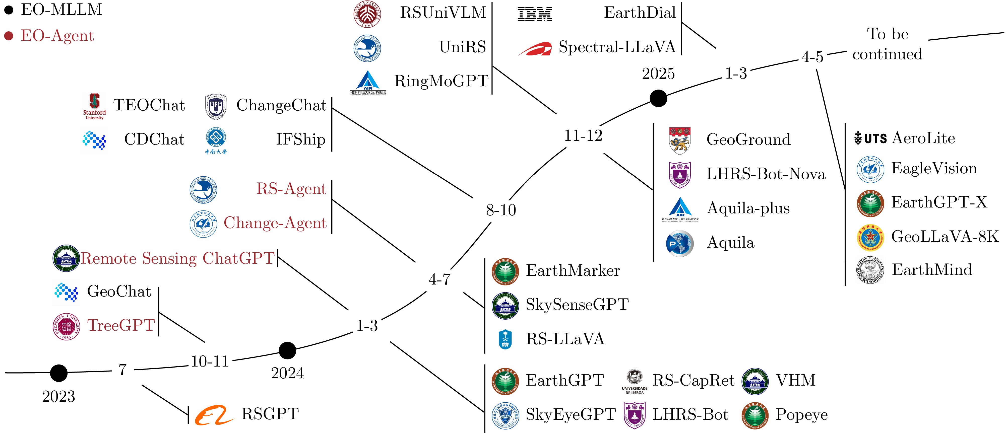
- Figure 2. Timeline of representative Earth Observation MLLMs (EO-MLLM) and Earth Observation Agents (EO-Agent)
- Figure 3. RS-Agent architecture