
 Submit Manuscript
 Peer Review
 Editor Work
- Home
- Articles & Issues
-
Data
- Dataset of Radar Detecting Sea
- SAR Dataset
- SARGroundObjectsTypes
- SARMV3D
- AIRSAT Constellation SAR Land Cover Classification Dataset
- 3DRIED
- UWB-HA4D
- LLS-LFMCWR
- FAIR-CSAR
- MSAR
- SDD-SAR
- FUSAR
- SpaceborneSAR3Dimaging
- Sea-land Segmentation
- SAR Multi-domain Ship Detection Dataset
- SAR-Airport
- Hilly and mountainous farmland time-series SAR and ground quadrat dataset
- SAR images for interference detection and suppression
- HP-SAR Evaluation & Analytical Dataset
- GDHuiYan-ATRNet
- Multi-System Maritime Low Observable Target Dataset
- DatasetinthePaper
- DatasetintheCompetition
- Report
- Course
- About
- Publish
- Editorial Board
- Chinese
| Citation: | WANG Jie, ZHANG Zhiyu, JIANG Yang, et al. Accuracy assessment of the antarctic digital elevation model based on the ICESat-2 elevation data[J]. Journal of Radars, 2025, 14(3): 576–588. doi: 10.12000/JR25068

|
Accuracy Assessment of the Antarctic Digital Elevation Model Based on the ICESat-2 Elevation Data
DOI: 10.12000/JR25068 CSTR: 32380.14.JR25068
More Information-
Abstract
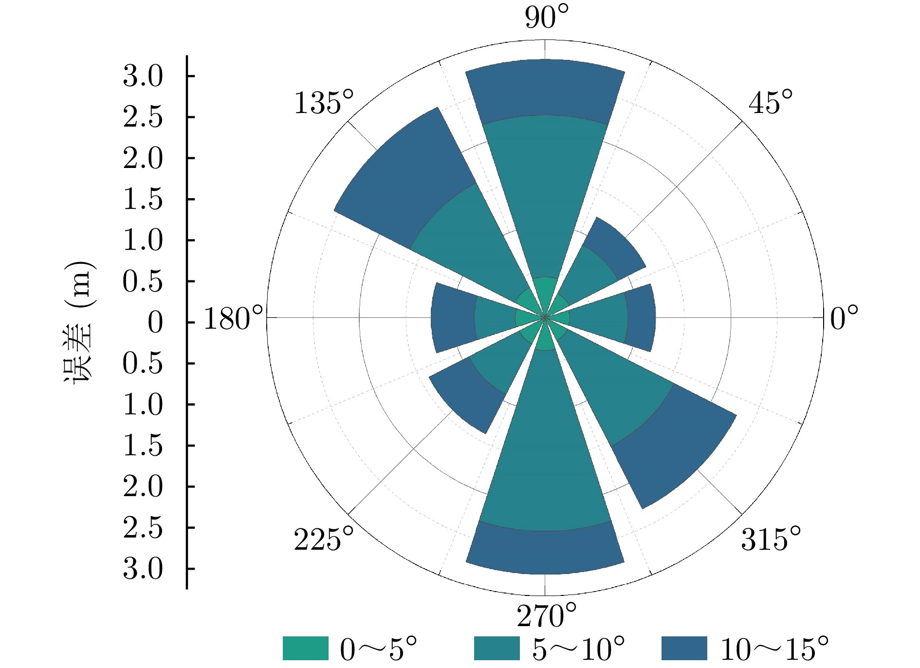
Antarctic Digital Elevation Models (DEMs) provide critical topographic support for polar scientific expeditions and enable the estimation of melt pond volumes. However, conventional ground calibration methods face implementation challenges in extreme Antarctic environments. Spaceborne Light Detection And Ranging (LiDAR) effectively addresses this limitation by directly acquiring high-precision surface elevation data. ICESat-2, a next-generation laser altimetry satellite, features an exceptionally small laser footprint spacing of merely 0.7 m. The elevation data products of ICESat-2 over the Antarctic ice sheet achieve centimeter-level accuracy using the Reference Elevation Model of Antarctica (REMA) source data. This study first validated the elevation accuracy of the ICESat-2 ATL06 (Advanced Topographic Laser Altimeter System Land Ice Height) data products using the IDHDT4 (IceBridge HiCARS Depth Digitizer Time Series, Version 4) data from the 2015 Operation IceBridge campaign of NASA in the McMurdo Dry Valleys region and mitigated disturbances from cloud cover, snowfall, and other factors through a quality control algorithm. Building upon this validation, this study systematically assessed the elevation accuracy of the 32 m resolution REMA DEM across selected low-ablation regions of the Antarctic ice sheet, delineated according to Antarctic drainage basin boundaries, using the ATL06 data as a reference. Results showed that REMA DEM achieves submeter accuracy (comparable to laser altimetry precision) in flat terrains with slopes below 5°, with a Root-Mean-Square Error (RMSE) of 0.72 m and a Mean Absolute Error (MAE) of 0.31 m. For moderate slopes of 5°–10°, the RMSE and MAE increased to 1.91 and 1.06 m, respectively; meanwhile, slopes of 10°–15° yielded values of 2.30 m (RMSE) and 1.57 m (MAE). Even at steeper slopes of 30°, the elevation error remained controlled, with the RMSE not exceeding 3.5 m. This study further quantified the impact of ground track orientation relative to slope aspect and seasonal variations. Track-aspect angles perpendicular to slopes intensify errors (e.g., RMSE increases by 170% at a slope of 15°), whereas seasonal differences in elevation errors remain minimal (i.e., <5%). The validation framework demonstrates the robustness of REMA DEM across diverse Antarctic terrains, providing a theoretical foundation for different applications, such as lake ice surface bathymetry inversion -

-
References
[1] 刘卓, 李佳, 张翔, 等. 利用TanDEM-X影像和ICESat-2高程数据获取南极高精度数字高程模型[J]. 测绘通报, 2022(4): 72–76. doi: 10.13474/j.cnki.11-2246.2022.0113.LIU Zhuo, LI Jia, ZHANG Xiang, et al. Obtaining high-precision digital elevation model in Antarctica based on TanDEM-X images and ICESat-2 data[J]. Bulletin of Surveying and Mapping, 2022(4): 72–76. doi: 10.13474/j.cnki.11-2246.2022.0113.[2] CUI Xiangbin, JEOFRY H, GREENBAUM J S, et al. Bed topography of princess elizabeth land in east Antarctica[J]. Earth System Science Data, 2020, 12(4): 2765–2774. doi: 10.5194/essd-12-2765-2020.[3] MORALES A, FIERREZ J, SÁNCHEZ J S, et al. Pattern Recognition and Image Analysis: 9th Iberian Conference, IbPRIA 2019, Madrid, Spain, July 1–4, 2019, Proceedings, Part I[M]. Cham: Springer, 2019. doi: 10.1007/978-3-030-31332-6.[4] HUANG Lanqing and HAJNSEK I. A study of sea ice topography in the Weddell and Ross seas using dual-polarimetric TanDEM-X imagery[J]. The Cryosphere, 2024, 18(7): 3117–3140. doi: 10.5194/tc-18-3117-2024.[5] FAN Yubin, KE Changqing, and SHEN Xiaoyi. A new Greenland digital elevation model derived from ICESat-2 during 2018–2019[J]. Earth System Science Data, 2022, 14(2): 781–794. doi: 10.5194/essd-14-781-2022.[6] SHEN Xiaoyi, KE Changqing, FAN Yubin, et al. A new digital elevation model (DEM) dataset of the entire Antarctic continent derived from ICESat-2[J]. Earth System Science Data, 2022, 14(7): 3075–3089. doi: 10.5194/essd-14-3075-2022.[7] DONG Yuting, ZHAO Ji, LI Caiyong, et al. Gapless-REMA100: A gapless 100-m reference elevation model of Antarctica with voids filled by multi-source DEMs[J]. ISPRS Journal of Photogrammetry and Remote Sensing, 2022, 186: 70–82. doi: 10.1016/j.isprsjprs.2022.01.024.[8] ZWALLY H J, MAJOR J A, BRENNER A C, et al. Ice measurements by geosat radar altimetry[J]. Johns Hopkins APL Technical Digest, 1987, 2: 251–254.[9] LIU Hongxing, JEZEK K C, and LI Biyan. Development of an Antarctic digital elevation model by integrating cartographic and remotely sensed data: A geographic information system based approach[J]. Journal of Geophysical Research: Solid Earth, 1999, 104(B10): 23199–23213. doi: 10.1029/1999JB900224.[10] DIMARZIO J P. GLAS/ICESat 500 m laser altimetry digital elevation model of Antarctica, version 1[R]. NSIDC-0304, 2007. doi: 10.5067/K2IMI0L24BRJ.[11] YU J, LIU Hongxing, and WANG Lei, et al. Blue ice areas and their topographical properties in the Lambert glacier, Amery Iceshelf system using Landsat ETM+, ICESat laser altimetry and ASTER GDEM data[J]. Antarctic Science, 2012, 24(1): 95–110. doi: 10.1017/S0954102011000630.[12] YANG Kang, SMITH L C, FETTWEIS X, et al. Surface meltwater runoff on the Greenland ice sheet estimated from remotely sensed supraglacial lake infilling rate[J]. Remote Sensing of Environment, 2019, 234: 111459. doi: 10.1016/j.rse.2019.111459.[13] LV Jinhao, LI Shaoyu, WANG Xiaoming, et al. Long-term satellite-derived bathymetry of Arctic supraglacial lake from ICESat-2 and Sentinel-2[J]. The International Archives of the Photogrammetry, Remote Sensing and Spatial Information Sciences, 2024, XLVIII-1-2024: 469–477. doi: 10.5194/isprs-archives-XLVIII-1-2024-469-2024.[14] LEESON A A, SHEPHERD A, PALMER S, et al. Simulating the growth of supraglacial lakes at the western margin of the Greenland ice sheet[J]. The Cryosphere, 2012, 6(5): 1077–1086. doi: 10.5194/tc-6-1077-2012.[15] HOWAT I M, PORTER C, SMITH B E, et al. The reference elevation model of Antarctica[J]. The Cryosphere, 2019, 13(2): 665–674. doi: 10.5194/tc-13-665-2019.[16] LI Yi, FU Haiqing, ZHU Jianjun, et al. A method for SRTM DEM elevation error correction in forested areas using ICESat-2 data and vegetation classification data[J]. Remote Sensing, 2022, 14(14): 3380. doi: 10.3390/rs14143380.[17] LIU Zhiwei, ZHU Jianjun, FU Haiqiang, et al. Evaluation of the vertical accuracy of open global DEMs over steep terrain regions using ICESat data: A case study over Hunan Province, China[J]. Sensors, 2020, 20(17): 4865. doi: 10.3390/s20174865.[18] CHEN Jun, XIONG Liyang, LI Sijin, et al. Global open-access DEM vertical elevation and along track neighbouring structure evaluations in the Tibetan Plateau using ICESat‐2 ATL03 points[J]. Earth Surface Processes and Landforms, 2025, 50(2): e6062. doi: 10.1002/esp.6062.[19] FOUNTAIN A G, NYLEN T H, MONAGHAN A, et al. Snow in the McMurdo Dry Valleys, Antarctica[J]. International Journal of Climatology, 2010, 30(5): 633–642. doi: 10.1002/joc.1933.[20] SCHENK T, CSATHO B, and NEUMANN T. Assessment of ICESat-2’s horizontal accuracy using precisely surveyed terrains in McMurdo Dry Valleys, Antarctica[J]. IEEE Transactions on Geoscience and Remote Sensing, 2022, 60: 4303811. doi: 10.1109/TGRS.2022.3147722.[21] LI Song, LIAO Jingjuan, and ZHANG Lianchong. Extraction and analysis of elevation changes in Antarctic ice sheet from CryoSat-2 and Sentinel-3 radar altimeters[J]. Journal of Applied Remote Sensing, 2022, 16(3): 034514. doi: 10.1117/1.JRS.16.034514.[22] NILSSON J, GARDNER A S, and PAOLO F S. Elevation change of the Antarctic ice sheet: 1985 to 2020[J]. Earth System Science Data, 2022, 14(8): 3573–3598. doi: 10.5194/essd-14-3573-2022.[23] SMITH B, FRICKER H A, HOLSCHUH N, et al. Land ice height-retrieval algorithm for NASA’s ICESat-2 photon-counting laser altimeter[J]. Remote Sensing of Environment, 2019, 233: 111352. doi: 10.1016/j.rse.2019.111352.[24] KOENIG L, MARTIN S, STUDINGER M, et al. Polar airborne observations fill gap in satellite data[J]. Eos, Transactions American Geophysical Union, 2010, 91(38): 333–334. doi: 10.1029/2010EO380002.[25] BLANKENSHIP D D, KEMPF S D, YOUNG D A, et al. IceBridge Riegl laser altimeter L2 geolocated surface elevation triplets, version 1[R]. ILUTP2, 2012. doi: 10.5067/JV9DENETK13E.[26] LEVINSEN J F, HOWAT I M, and TSCHERNING C C. Improving maps of ice-sheet surface elevation change using combined laser altimeter and stereoscopic elevation model data[J]. Journal of Glaciology, 2013, 59(215): 524–532. doi: 10.3189/2013JoG12J114.[27] WESSEL B, HUBER M, WOHLFART C, et al. Accuracy assessment of the global TanDEM-X digital elevation model with GPS data[J]. ISPRS Journal of Photogrammetry and Remote Sensing, 2018, 139: 171–182. doi: 10.1016/j.isprsjprs.2018.02.017.[28] GARDNER C S. Ranging performance of satellite laser altimeters[J]. IEEE Transactions on Geoscience and Remote Sensing, 1992, 30(5): 1061–1072. doi: 10.1109/36.175341.[29] MARKUS T, NEUMANN T, MARTINO A, et al. The ice, cloud, and land elevation satellite-2 (ICESat-2): Science requirements, concept, and implementation[J]. Remote Sensing of Environment, 2017, 190: 260–273. doi: 10.1016/j.rse.2016.12.029.[30] SHEN X, KE C Q, YU X, et al. Evaluation of ice, cloud, and land elevation satellite-2 (ICESat-2) land ice surface heights using Airborne Topographic Mapper (ATM) data in Antarctica[J]. International Journal of Remote Sensing, 2021, 42(7): 2556–2573. doi: 10.1080/01431161.2020.1856962.[31] VARGA M and BAŠIĆ T. Accuracy validation and comparison of global digital elevation models over Croatia[J]. International Journal of Remote Sensing, 2015, 36(1): 170–189. doi: 10.1080/01431161.2014.994720.[32] AFSHARNIA H, AREFI H, and ABBASI M. Geometric correction of satellite stereo images by DEM matching without ground control points and map projection step: Tested on Cartosat-1 images[J]. Earth Science Informatics, 2022, 15(2): 1183–1199. doi: 10.1007/s12145-022-00799-3.[33] YE Jiang, QIANG Yuxuan, ZHANG Rui, et al. High-precision digital surface model extraction from satellite stereo images fused with ICESat-2 data[J]. Remote Sensing, 2021, 14(1): 142. doi: 10.3390/rs14010142.[34] HABIB M. Evaluation of DEM interpolation techniques for characterizing terrain roughness[J]. CATENA, 2021, 198: 105072. doi: 10.1016/j.catena.2020.105072.[35] 陈昊楠, 许诗枫, 黄艳, 等. ASTER GDEM V2的南极冰川高程误差校正及精度分析[J]. 遥感学报, 2020, 24(8): 1010–1022. doi: 10.11834/jrs.20208361.CHEN Haonan, XU Shifeng, HUANG Yan, et al. Vertical accuracy correction and analysis of ASTER GDEM V2 over Antarctic glacier[J]. Journal of Remote Sensing (Chinese), 2020, 24(8): 1010–1022. doi: 10.11834/jrs.20208361.[36] DALIAKOPOULOS I N and TSANIS I K. A SIFT-based DEM extraction approach using GEOEYE-1 satellite stereo pairs[J]. Sensors, 2019, 19(5): 1123. doi: 10.3390/s19051123.[37] ANAND V, OINAM B, and WIEPRECHT S. Assessment and comparison of DEM generated using cartosat-1 stereo pair data for hydrological applications[J]. Journal of the Indian Society of Remote Sensing, 2023, 51(3): 483–496. doi: 10.1007/s12524-022-01639-z. -
Proportional views

- Publishing Ethics
- Journal Insights
- Abstracting & Indexing
- Peer Review Policies
- Guide for Authors
- Conference
- ISSN 2095-283X (Print)ISSN 2097-339X (Online)
- CN 10-1030/TN
- CODEN LXEUAO
About Journal
- Sponsor: China Radio Detection and Ranging Industry Association (CRIA)
- Phone: 010-58887062
- Email:radars@aircas.ac.cn
- Publisher: Leida Xuebao Bianjibu (Editorial office of the Journal of Radars)
Contacts Us

京ICP备20021838号-14
Supported by: Beijing Renhe Information Technology Co. Ltd

Export File
Citation
Format
Content
 DownLoad:
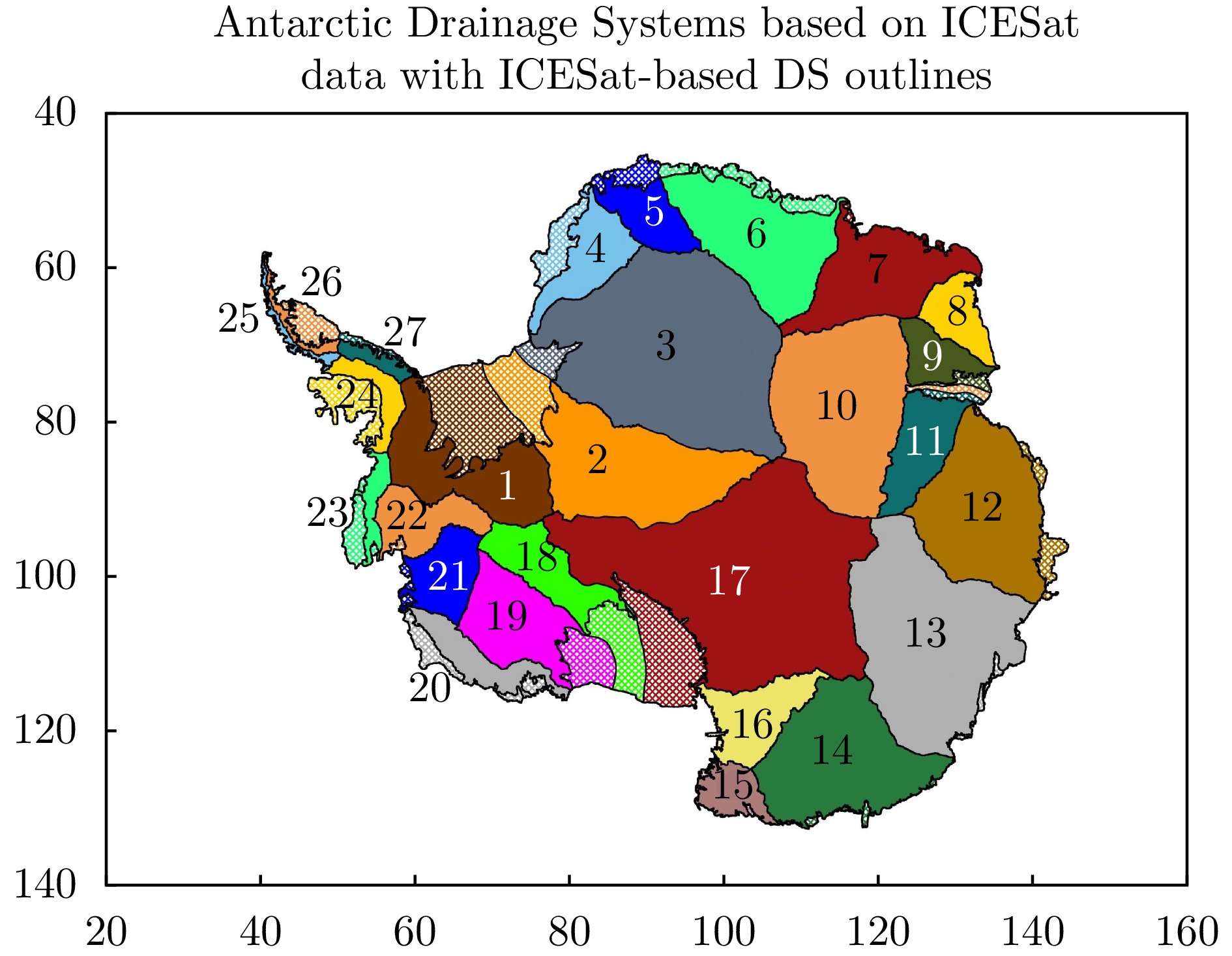
- Figure 1. Map of the Antarctic drainage divisions[17]
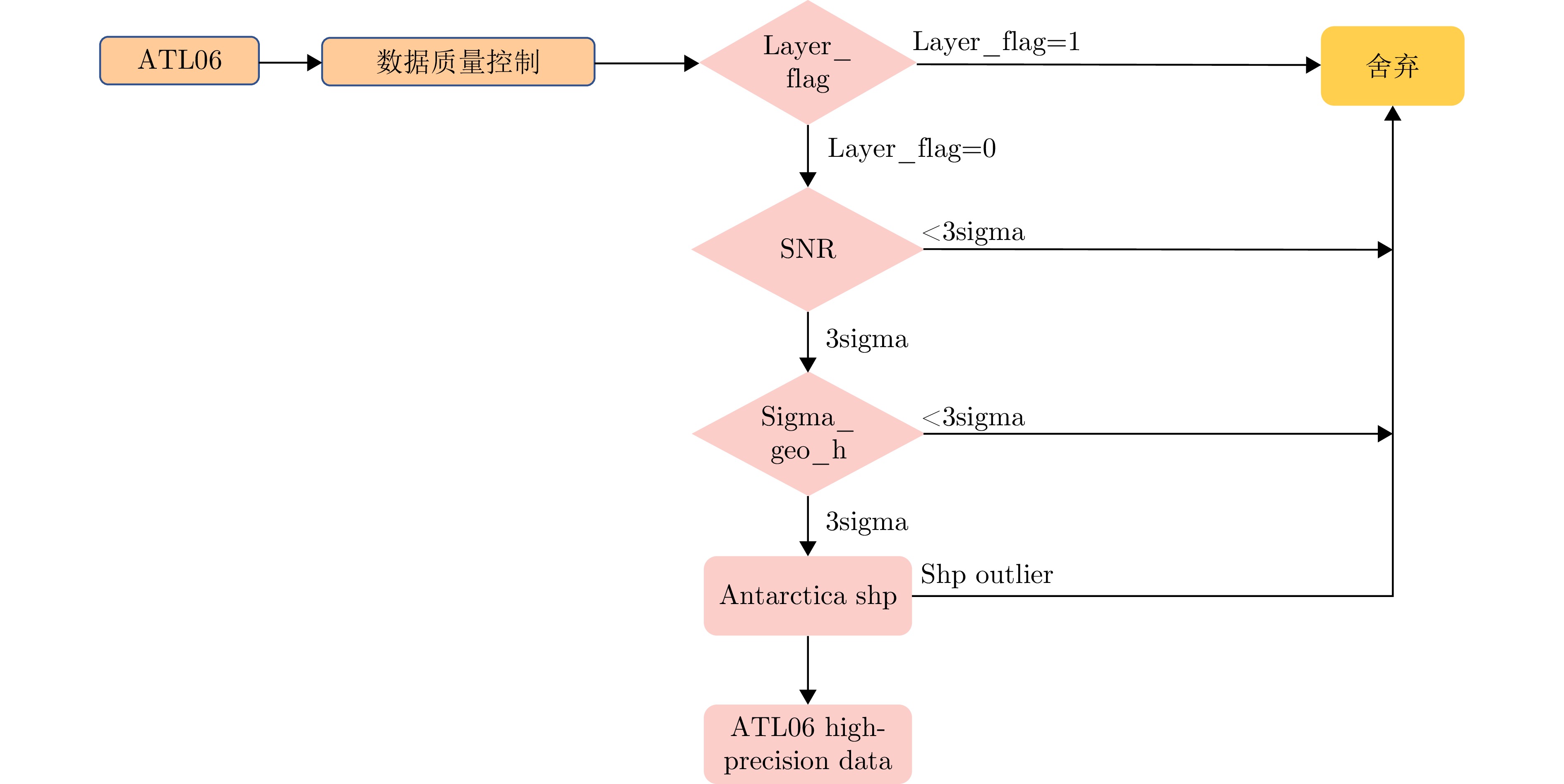
- Figure 2. Flow chart of the ATL06 quality control procedure
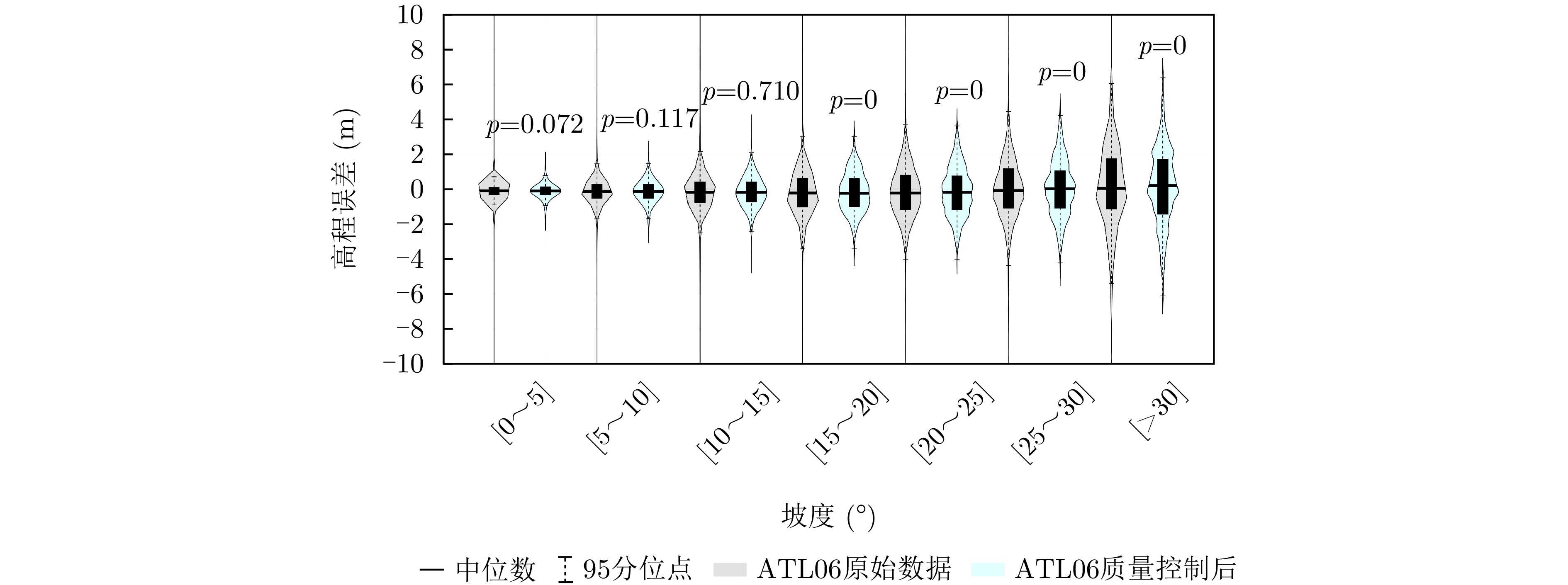
- Figure 3. Distribution of residual error of ATL06 data product before and after quality control
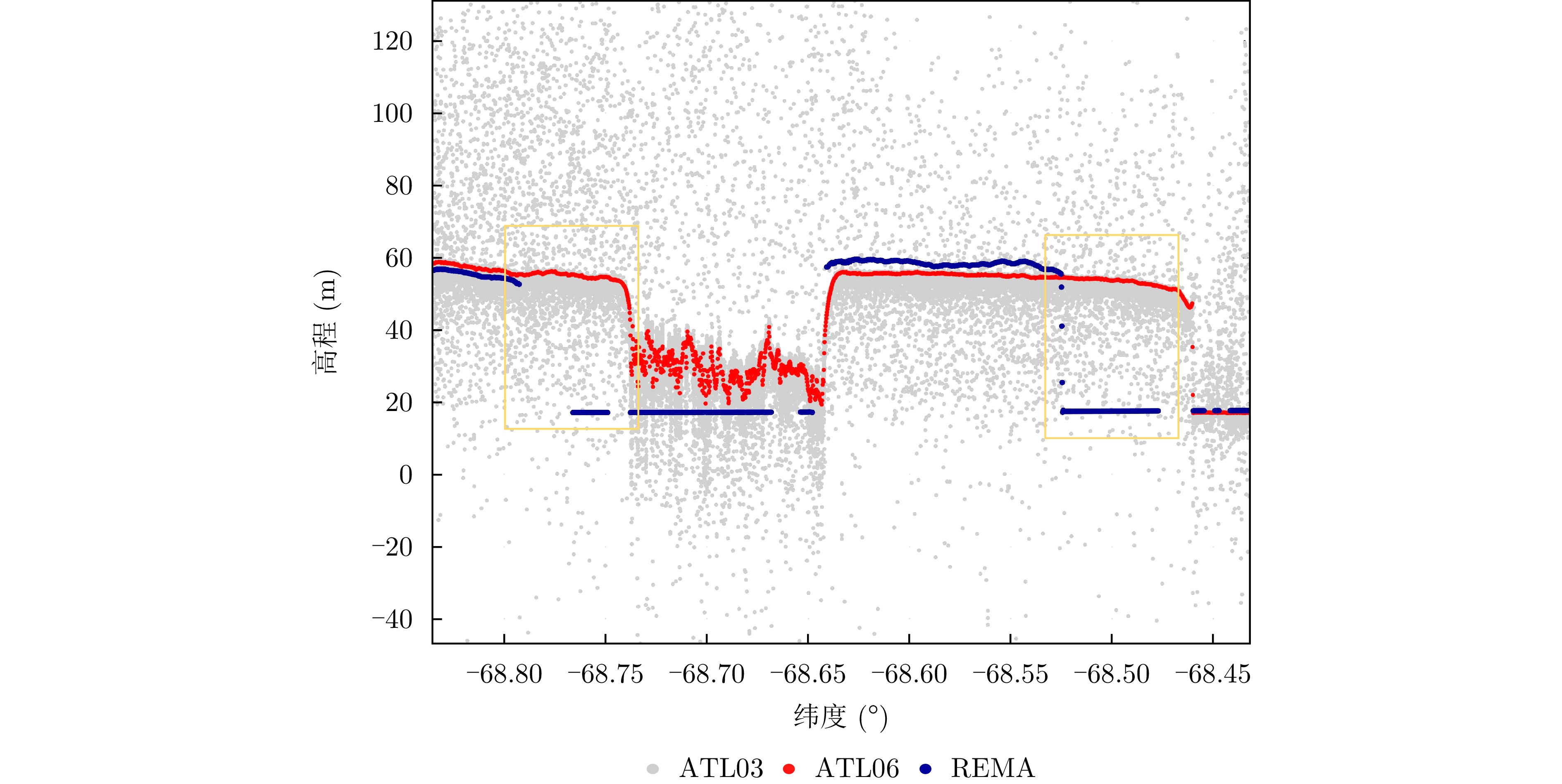
- Figure 4. Anomalies of REMA DEM in sea ice area
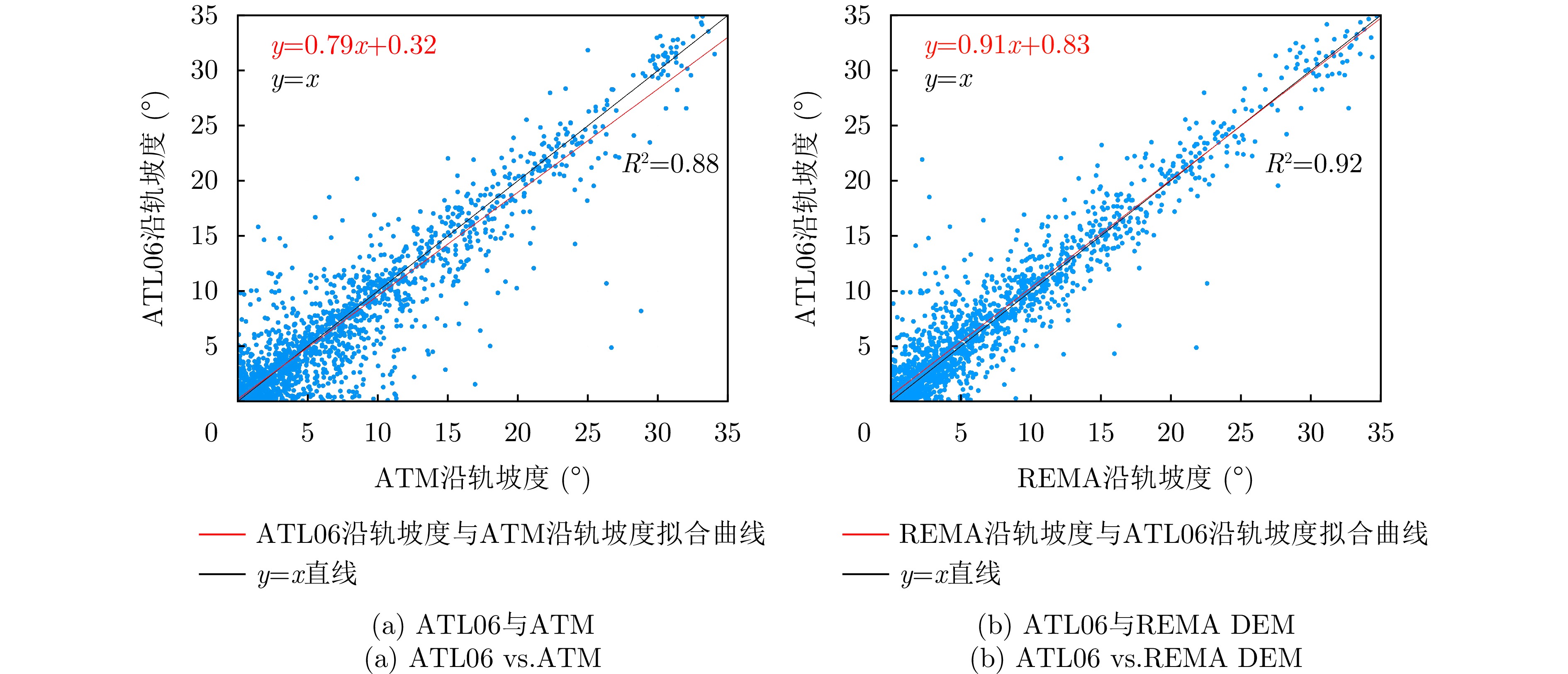
- Figure 5. Multi-source along-track slope consistency analysis
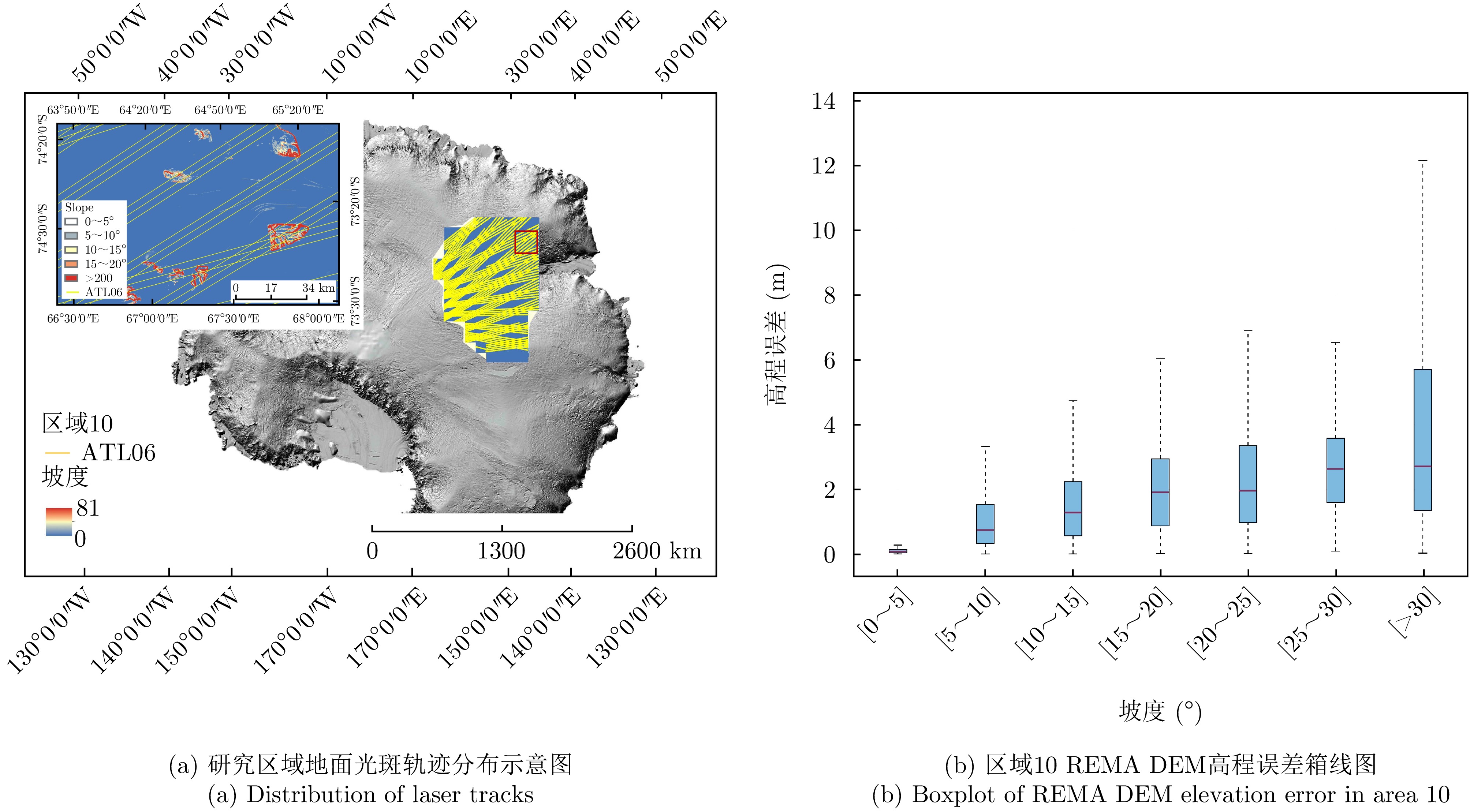
- Figure 6. ICESat-2 ground tracks in area 10 and REMA DEM accuracy validation
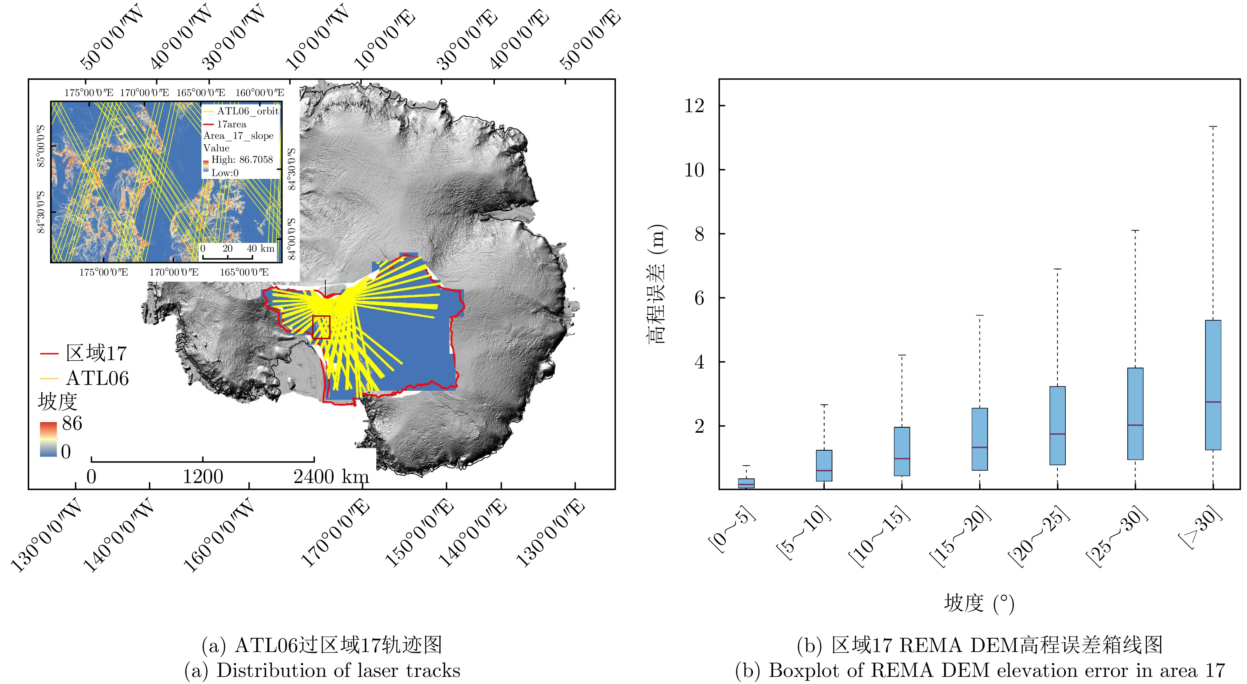
- Figure 7. ICESat-2 ground tracks in area 17 and REMA DEM accuracy validation
- Figure 8. Elevation error vs. the angles between the DEM slope direction and ICESat-2 ground track orientation