
 Submit Manuscript
 Peer Review
 Editor Work
- Home
- Articles & Issues
-
Data
- Dataset of Radar Detecting Sea
- SAR Dataset
- SARGroundObjectsTypes
- SARMV3D
- AIRSAT Constellation SAR Land Cover Classification Dataset
- 3DRIED
- UWB-HA4D
- LLS-LFMCWR
- FAIR-CSAR
- MSAR
- SDD-SAR
- FUSAR
- SpaceborneSAR3Dimaging
- Sea-land Segmentation
- SAR Multi-domain Ship Detection Dataset
- SAR-Airport
- Hilly and mountainous farmland time-series SAR and ground quadrat dataset
- SAR images for interference detection and suppression
- HP-SAR Evaluation & Analytical Dataset
- GDHuiYan-ATRNet
- Multi-System Maritime Low Observable Target Dataset
- DatasetinthePaper
- DatasetintheCompetition
- Report
- Course
- About
- Publish
- Editorial Board
- Chinese
| Citation: | DAI Keren, TIE Yongbo, XU Qiang, et al. Early identification of potential landslide geohazards in alpine-canyon terrain based on SAR interferometry—a case study of the middle section of yalong river[J]. Journal of Radars, 2020, 9(3): 554–568. doi: 10.12000/JR20012

|
Early Identification of Potential Landslide Geohazards in Alpine-canyon Terrain Based on SAR Interferometry—a Case Study of the Middle Section of Yalong River (in English)
DOI: 10.12000/JR20012 CSTR: 32380.14.JR20012
More Information-
Abstract
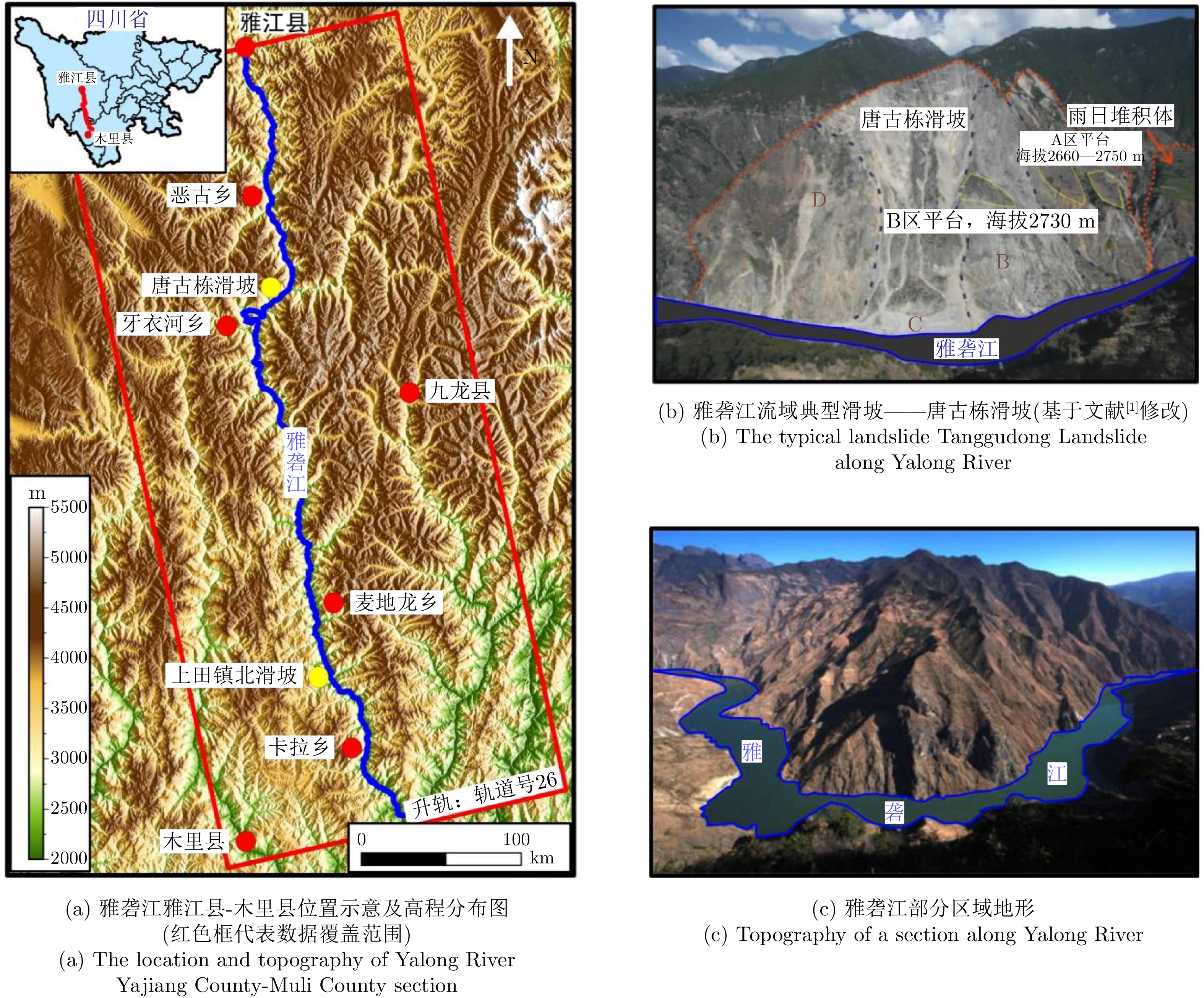
Landslide disasters occur frequently in the western mountainous regions of China and are characterized by high concealment, suddenness, and strong destructiveness. Early identification of potential disaster hazards is the most effective prevention and mitigation measure. The western mountainous areas mostly have a wide range of alpine-canyon terrain, which is hard or even impossible to reach. Moreover, traditional early identification methods, such as manual inspection, are difficult to implement in these areas. As an emerging radar remote-sensing method, Interferometric Synthetic Aperture Radar (InSAR) can efficiently and accurately identify the hidden dangers of landslides. Based on the synthetic aperture radar data of the European Space Agency’s Sentinel-1, this study used time series InSAR technology to identify the potential landslide hazards in the alpine-canyon terrain along the Yajiang-Muli County of the Yalong River; eight potential geohazards were detected. On the basis of the historical data of landslide hazards and the interpretation of optical remote sensing data, the results of early identification were verified and analyzed, and the danger level of the disaster points was evaluated. The influence of geometric distortion in InSAR technology on the early identification of potential landslides in alpine-canyon terrain was also discussed. This case study can provide powerful data and technical support for local disaster prevention and mitigation and provide ideas and references for the early identification of the hidden dangers of landslides in mountain-valley areas. -

-
References
[1] 刘哲. 基于GIS的雅砻江流域麦地龙—卡拉段地质灾害危险性评价[D]. [硕士论文], 成都理工大学, 2015.LIU Zhe. Hazard assessment of geological disasters in the Yalong River basin from the Maidilong to Kala based on GIS[D]. [Master dissertation], Chengdu University of Technology, 2015.[2] 常晓军, 魏伦武, 王德伟. 雅砻江流域地质灾害分布特征及其影响因素分析[J]. 灾害学, 2009, 24(3): 83–88. doi: 10.3969/j.issn.1000-811X.2009.03.017CHANG Xiaojun, WEI Lunwu, and WANG Dewei. Distribution characteristics and influencing factors of geological hazards in Yalong River basin[J]. Journal of Catastrophology, 2009, 24(3): 83–88. doi: 10.3969/j.issn.1000-811X.2009.03.017[3] 王孔伟, 邓成进, 张帆. 中国西南雅砻江流域唐古栋滑坡及雨日堆积体形成机理分析[J]. 工程地质学报, 2012, 20(6): 955–970. doi: 10.3969/j.issn.1004-9665.2012.06.007WANG Kongwei, DENG Chengjin, and ZHANG Fan. Formation process of Tanggudong landslide and Yuri accumulation body in Yalong River valley in southwest China[J]. Journal of Engineering Geology, 2012, 20(6): 955–970. doi: 10.3969/j.issn.1004-9665.2012.06.007[4] 梁瑞锋, 杨敏, 杨栓成, 等. 雅砻江流域卡拉段地质灾害分布特征与影响因素分析[J]. 人民珠江, 2016, 37(11): 13–17. doi: 10.3969/j.issn.1001-9235.2016.11.003LIANG Ruifeng, YANG Min, YANG Shuancheng, et al. Distribution characteristics and influencing factors analysis of geological disasters in Kala section along Yalong River[J]. Pearl River, 2016, 37(11): 13–17. doi: 10.3969/j.issn.1001-9235.2016.11.003[5] 陆会燕, 李为乐, 许强, 等. 光学遥感与InSAR结合的金沙江白格滑坡上下游滑坡隐患早期识别[J]. 武汉大学学报: 信息科学版, 2019, 44(9): 1342–1354.LU Huiyan, LI Weile, XU Qiang, et al. Early detection of landslides in the upstream and downstream areas of the Baige Landslide, the Jinsha River based on optical remote sensing and InSAR technologies[J]. Geomatics and Information Science of Wuhan University, 2019, 44(9): 1342–1354.[6] 葛大庆, 戴可人, 郭兆成, 等. 重大地质灾害隐患早期识别中综合遥感应用的思考与建议[J]. 武汉大学学报: 信息科学版, 2019, 44(7): 949–956.GE Daqing, DAI Keren, GUO Zhaocheng, et al. Early identification of serious geological hazards with integrated remote sensing technologies: Thoughts and recommendations[J]. Geomatics and Information Science of Wuhan University, 2019, 44(7): 949–956.[7] XIA Y. CR-based SAR-interferometry for landslide monitoring[C]. 2008 IEEE International Geoscience and Remote Sensing Symposium, Boston, USA, 2008. doi: 10.1109/IGARSS.2008.4779226.[8] 王腾. 时间序列InSAR数据分析技术及其在三峡地区的应用[D]. [博士论文], 武汉大学, 2010.WANG Teng. Time series InSAR analysis over the Three Gorges Region: Techniques and applications[D]. [Ph. D. dissertation], Wuhan University, 2010.[9] XU Qiang, YUAN Yong, ZENG Yuping, et al. Some new pre-warning criteria for creep slope failure[J]. Science China Technological Sciences, 2011, 54(1): 210–220. doi: 10.1007/s11431-011-4640-5[10] 戴可人, 卓冠晨, 许强, 等. 雷达干涉测量对甘肃南峪乡滑坡灾前二维形变追溯[J]. 武汉大学学报: 信息科学版, 2019, 44(12): 1778–1786, 1796.DAI Keren, ZHUO Guanchen, XU Qiang, et al. Tracing the pre-failure two-dimensional surface displacements of Nanyu landslide, Gansu province with radar interferometry[J]. Geomatics and Information Science of Wuhan University, 2019, 44(12): 1778–1786, 1796.[11] DONG Jie, ZHANG Lu, TANG Minggao, et al. Mapping landslide surface displacements with time series SAR interferometry by combining persistent and distributed scatterers: A case study of Jiaju landslide in Danba, China[J]. Remote Sensing of Environment, 2018, 205: 180–198. doi: 10.1016/j.rse.2017.11.022[12] 张毅. 基于InSAR技术的地表变形监测与滑坡早期识别研究—以白龙江流域中游为例[D]. [博士论文], 兰州大学, 2018.ZHANG Yi. Detecting ground deformation and investigating landslides using InSAR technique—taking middle reach of Bailong River basin as an example[D]. [Ph. D. dissertation], Lanzhou University, 2018.[13] 张路, 廖明生, 董杰, 等. 基于时间序列InSAR分析的西部山区滑坡灾害隐患早期识别—以四川丹巴为例[J]. 武汉大学学报: 信息科学版, 2018, 43(12): 2039–2049. doi: 10.13203/j.whugis20180181ZHANG Lu, LIAO Mingsheng, DONG Jie, et al. Early detection of landslide hazards in mountainous areas of west China using time series SAR interferometry—a case study of Danba, Sichuan[J]. Geomatics and Information Science of Wuhan University, 2018, 43(12): 2039–2049. doi: 10.13203/j.whugis20180181[14] 张亚迪, 李煜东, 董杰, 等. 时序InSAR技术探测芒康地区滑坡灾害隐患[J]. 遥感学报, 2019, 23(5): 987–996.ZHANG Yadi, LI Yudong, DONG Jie, et al. Landslide hazard detection in Markam with time-series InSAR analyses[J]. Journal of Remote Sensing, 2019, 23(5): 987–996.[15] DAI Keren, CHEN Gang, XU Qiang, et al. Potential landslide early detection near Wenchuan by a qualitatively multi-baseline DInSAR method[C]. ISPRS Technical Commission III Midterm Symposium on "Developments, Technologies and Applications in Remote Sensing", Beijing, China, 2018: 253–256.[16] 李振洪, 宋闯, 余琛, 等. 卫星雷达遥感在滑坡灾害探测和监测中的应用: 挑战与对策[J]. 武汉大学学报: 信息科学版, 2019, 44(7): 967–979. doi: 10.13203/j.whugis20190098LI Zhenhong, SONG Chuang, YU Chen, et al. Application of satellite radar remote sensing to landslide detection and monitoring: challenges and solutions[J]. Geomatics and Information Science of Wuhan University, 2019, 44(7): 967–979. doi: 10.13203/j.whugis20190098[17] 冷伦, 冷荣梅. 雅砻江垮山洪水和历史的教训[J]. 四川水利, 2002, 23(2): 42–44.LENG Lun and LENG Rongmei. Mountain slide flood in Yalong river and historical lesson[J]. Sichuan Water Conservancy, 2002, 23(2): 42–44.[18] 伍超, 冉洪兴, 郑永红, 等. 雅砻江唐古栋垮山堵江溃决洪水过程研究[J]. 水动力学研究与进展, 1999, 11A: 646–652.WU Chao, RAN Hongxing, ZHENG Yonghong, et al. Hydrograph of the dam-break flood of the reservoir formed by mountain collapse in Ya Longjiang[J]. Journal of Hydrodynamics, 1999, 11A: 646–652.[19] 武运泊. 雅砻江卡拉地区滑坡发育规律与成因机制分析[D]. [硕士论文], 成都理工大学, 2015.WU Yunbo. Analysis of development law and genetic mechanism of the landsides in Kala area, Yalong River[D]. [Master dissertation], Chengdu University of Technology, 2015.[20] 黄润秋. 20世纪以来中国的大型滑坡及其发生机制[J]. 岩石力学与工程学报, 2007, 26(3): 433–454. doi: 10.3321/j.issn:1000-6915.2007.03.001HUANG Runqiu. Large-scale landslides and their sliding mechanisms in China since the 20th century[J]. Chinese Journal of Rock Mechanics and Engineering, 2007, 26(3): 433–454. doi: 10.3321/j.issn:1000-6915.2007.03.001[21] BERARDINO P, FORNARO G, LANARI R, et al. A new algorithm for surface deformation monitoring based on small baseline differential SAR interferograms[J]. IEEE Transactions on Geoscience and Remote Sensing, 2002, 40(11): 2375–2383. doi: 10.1109/TGRS.2002.803792[22] DAI Keren, LI Zhenhong, TOMÁS R, et al. Monitoring activity at the Daguangbao mega-landslide (China) using Sentinel-1 TOPS time series interferometry[J]. Remote Sensing of Environment, 2016, 186: 501–513. doi: 10.1016/j.rse.2016.09.009[23] COLESANTI C and WASOWSKI J. Investigating landslides with space-borne Synthetic Aperture Radar (SAR) interferometry[J]. Engineering Geology, 2006, 88(3/4): 173–199.[24] DAI Keren, LI Zhenhong, XU Qiang, et al. Entering the era of earth observation-based landslide warning systems: A novel and exciting framework[J]. IEEE Geoscience and Remote Sensing Magazine, 2020, 8(1): 136–153. doi: 10.1109/MGRS.2019.2954395 -
Proportional views

- Publishing Ethics
- Journal Insights
- Abstracting & Indexing
- Peer Review Policies
- Guide for Authors
- Conference
- ISSN 2095-283X (Print)ISSN 2097-339X (Online)
- CN 10-1030/TN
- CODEN LXEUAO
About Journal
- Sponsor: China Radio Detection and Ranging Industry Association (CRIA)
- Phone: 010-58887062
- Email:radars@aircas.ac.cn
- Publisher: Leida Xuebao Bianjibu (Editorial office of the Journal of Radars)
Contacts Us

京ICP备20021838号-14
Supported by: Beijing Renhe Information Technology Co. Ltd

Export File
Citation
Format
Content
 DownLoad:


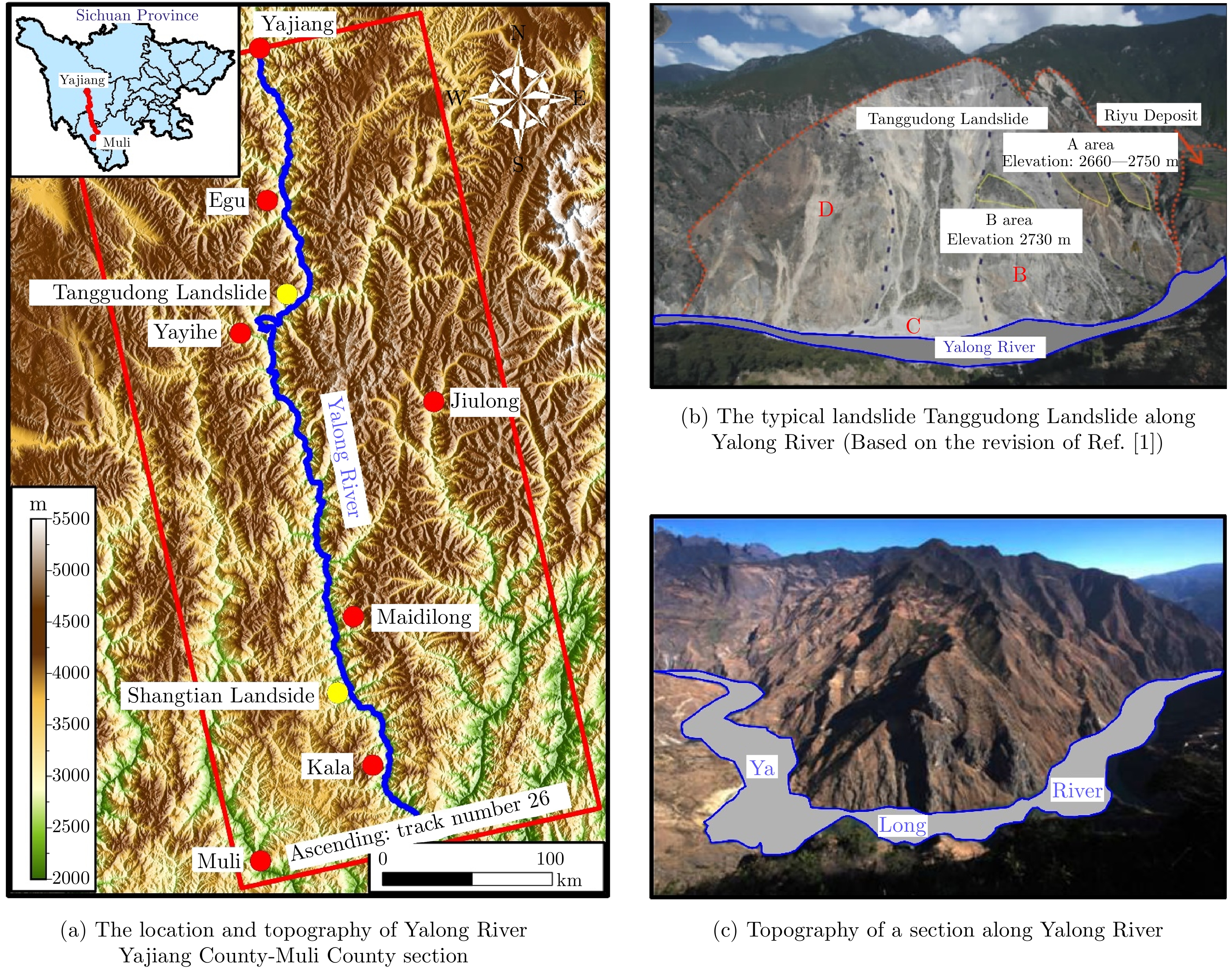


- Figure 1. Study area
- Figure 2. Spatial and temporal baselines of SAR datasets
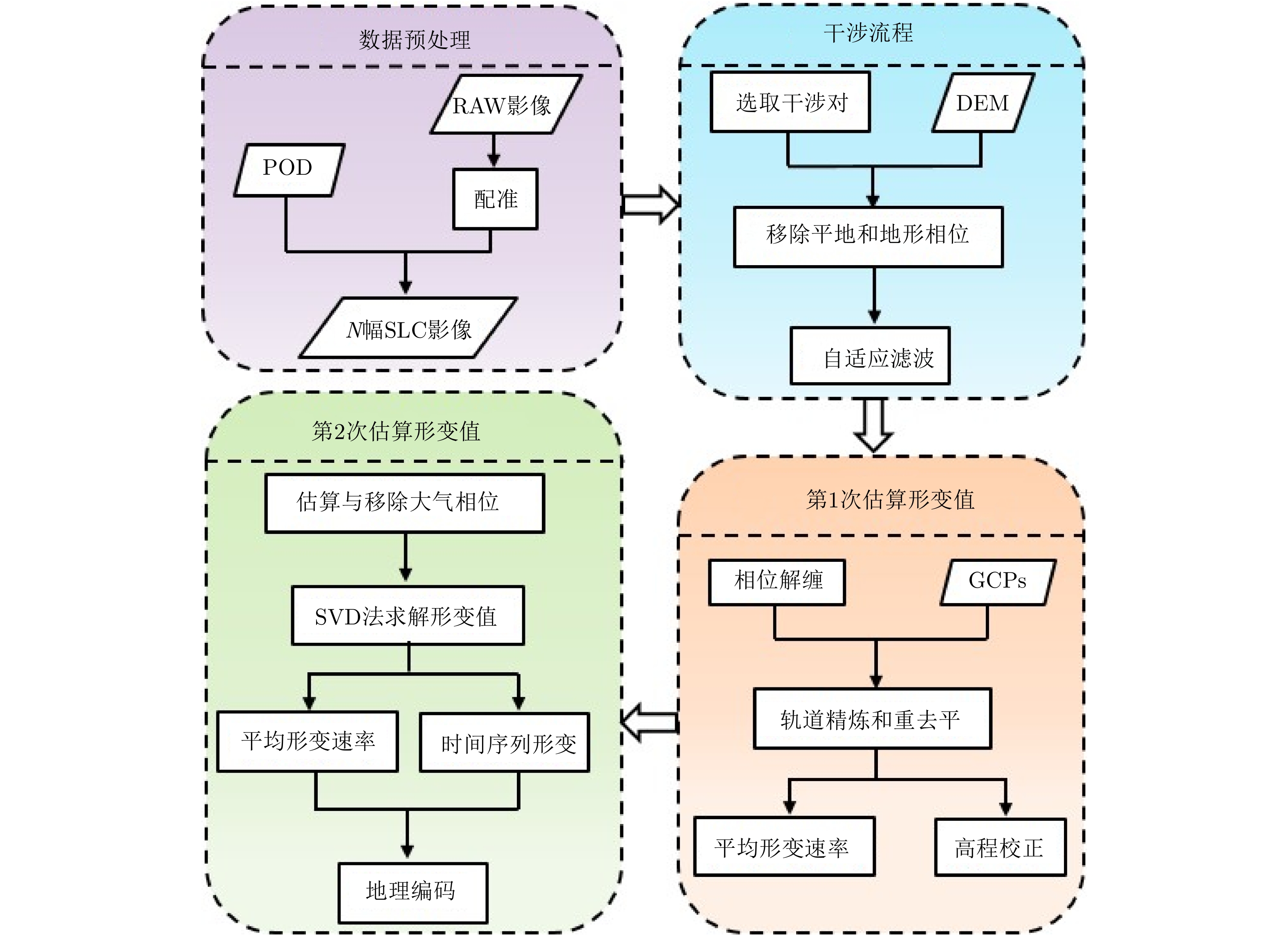
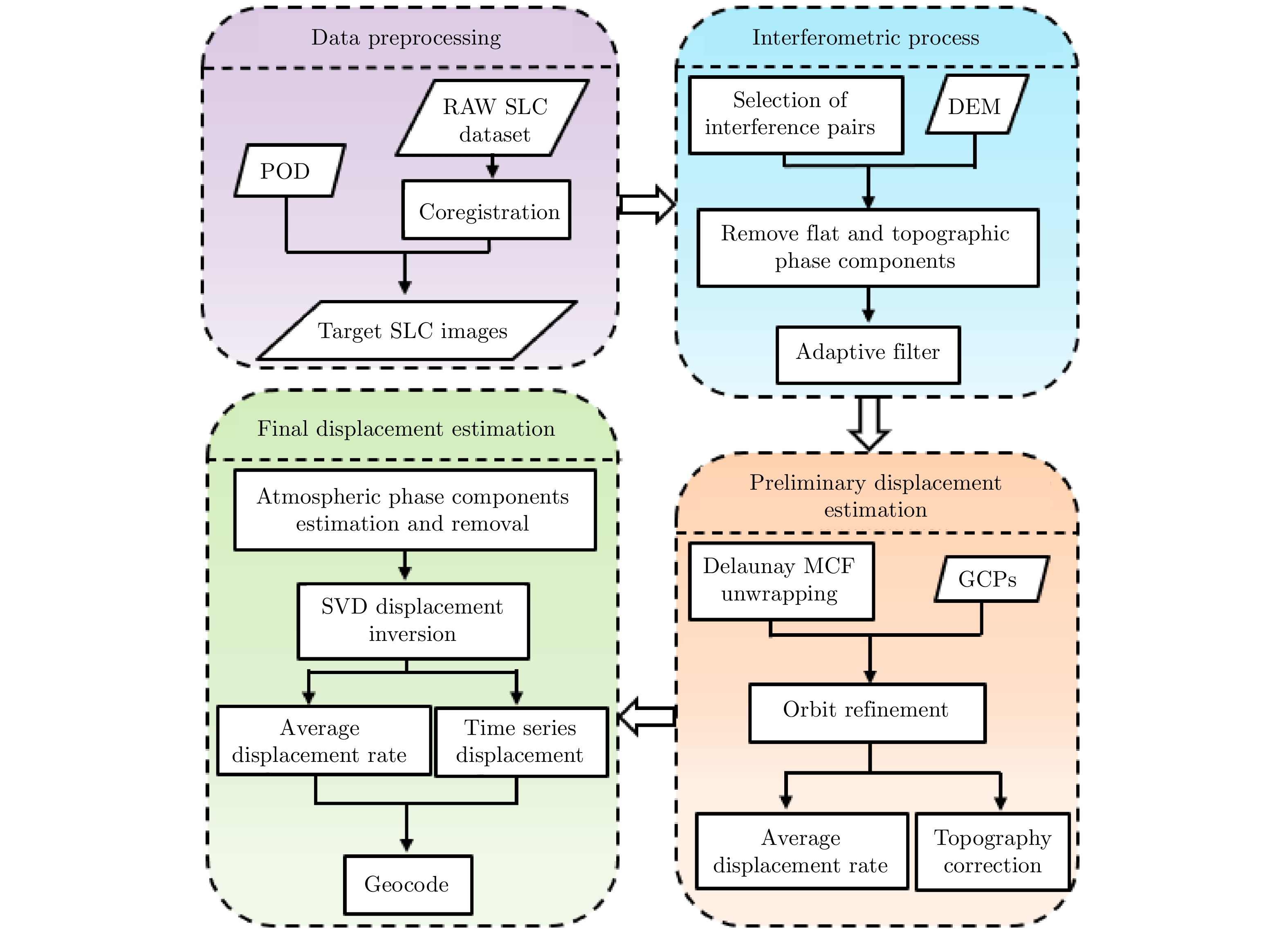
- Figure 3. Flowchart of SBAS-InSAR time series analysis
- Figure 4. Mean velocity map derived from InSAR
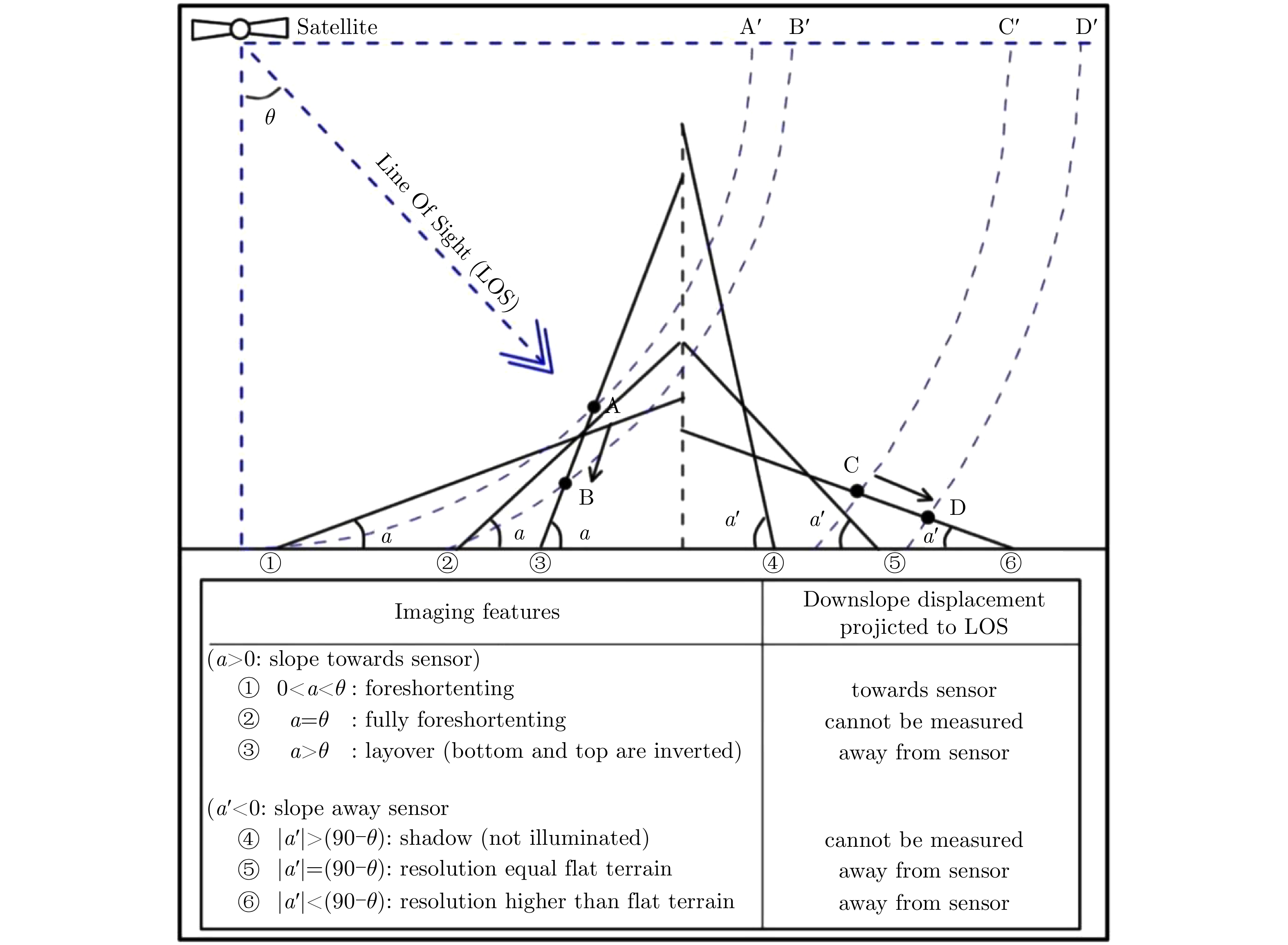
- Figure 8. Relationships between the Line Of Sight (LOS) and the downslope displacements for different slope orientations (adapted from Ref. [22])
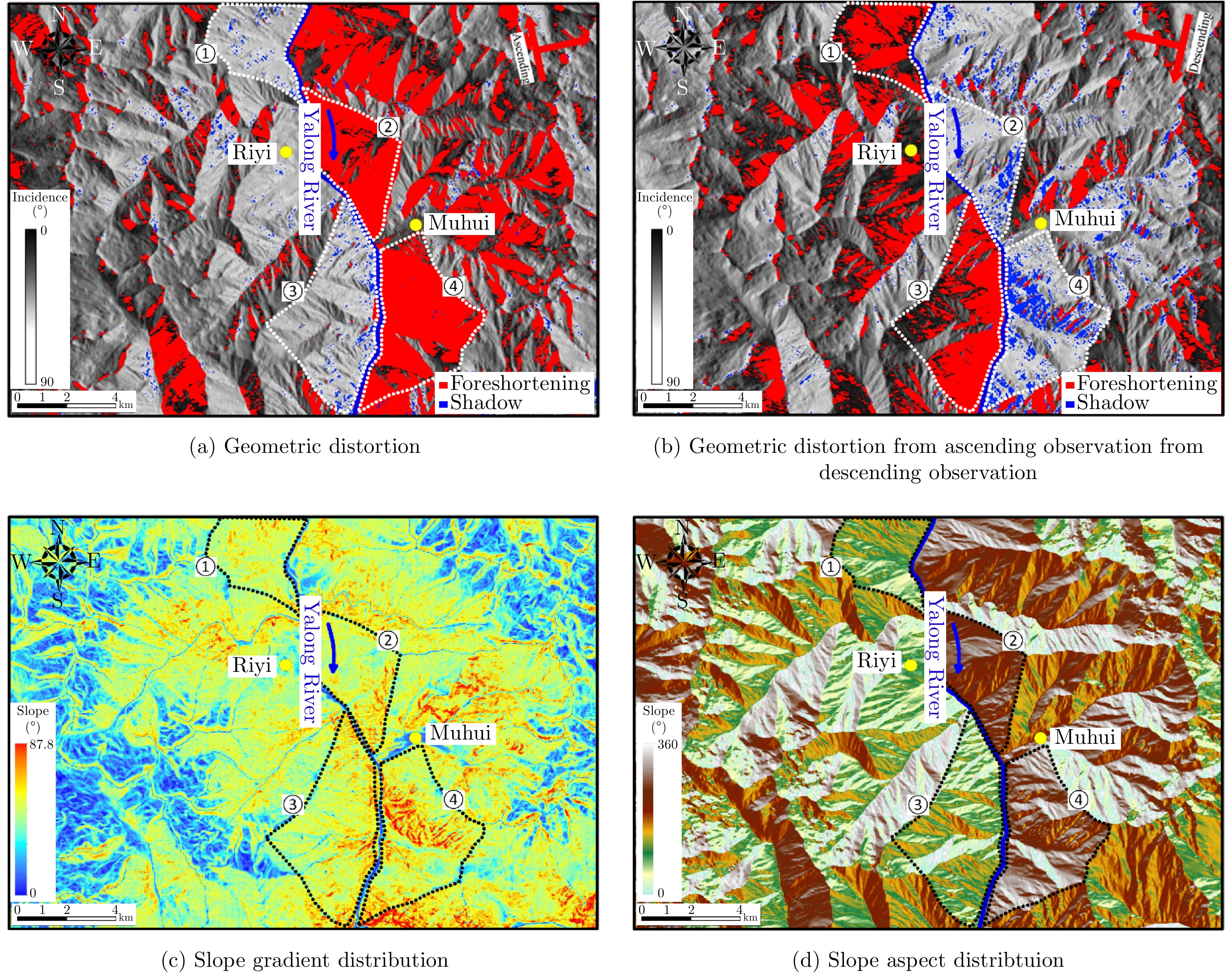
- Figure 9. Geometric distortion of Sentinel-1 datasets along Yalong River
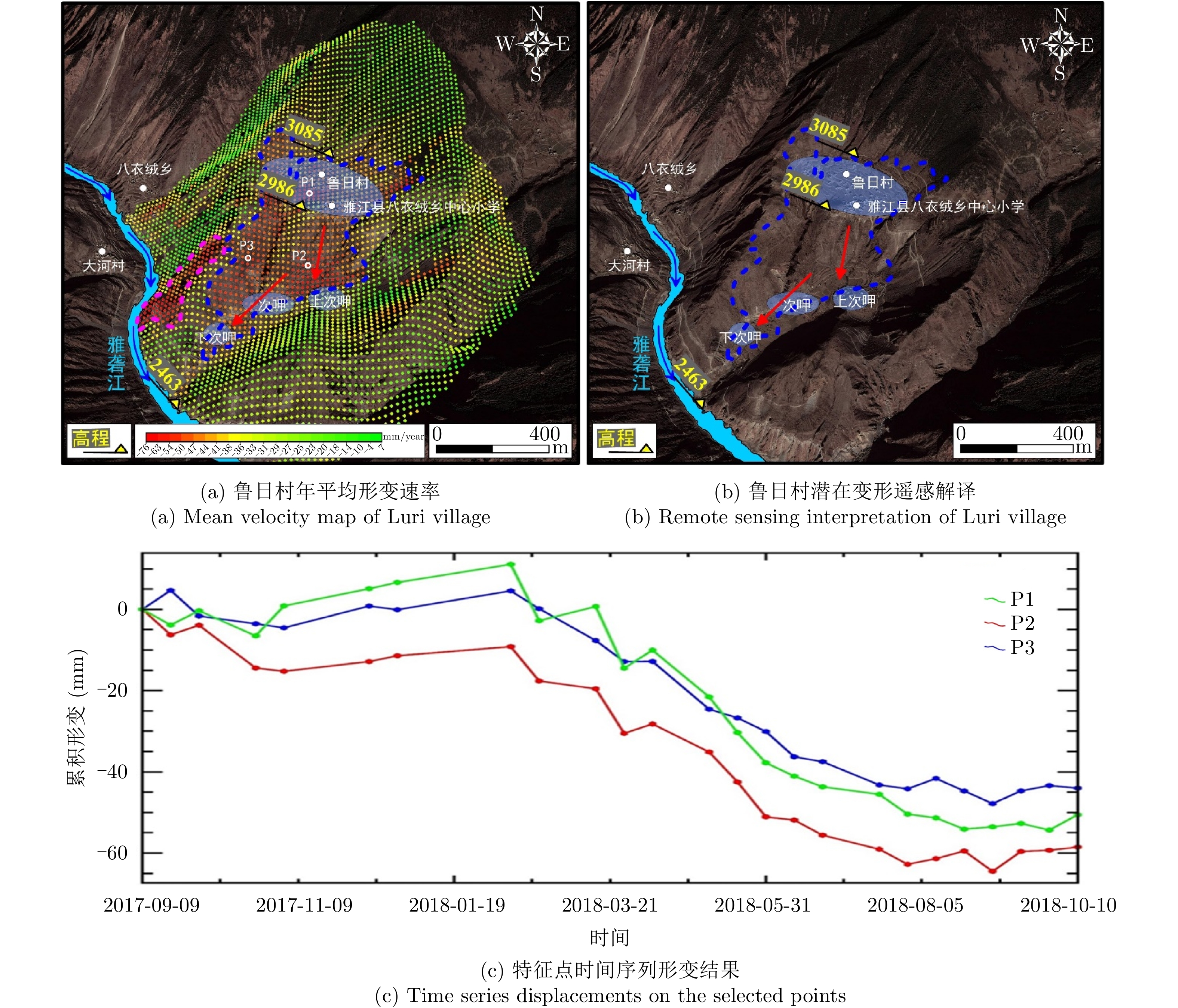
- Figure 5. Early identification results of potential landslide geohazards in Luri village
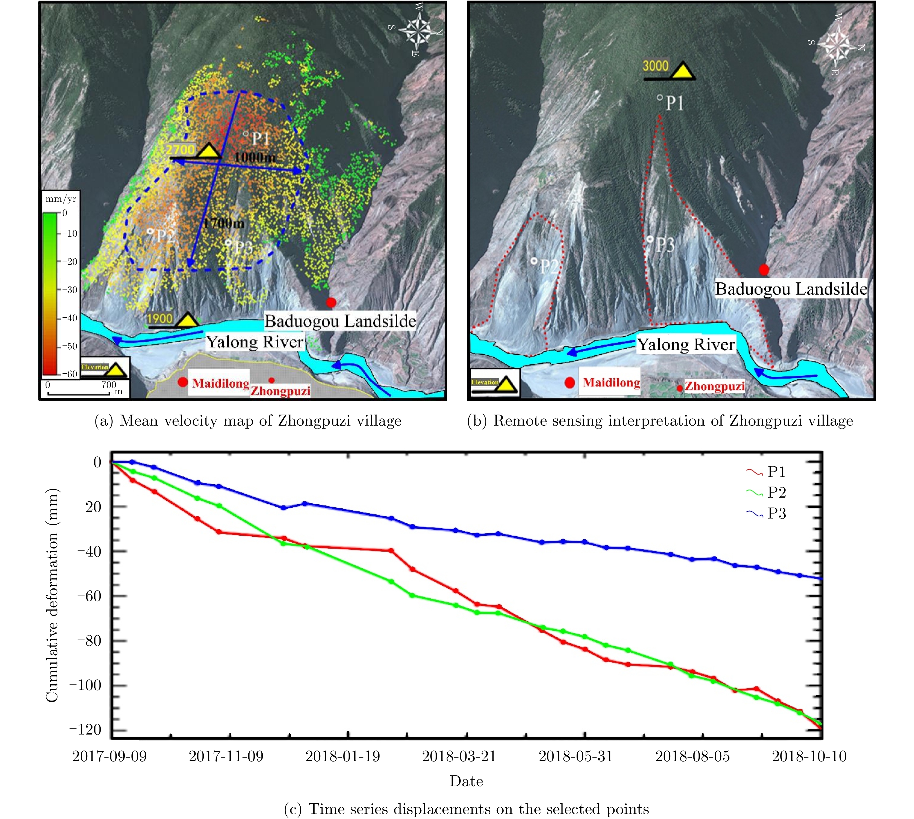
- Figure 6. Early identification results of potential landslide geohazards in Zhongpuzi village
- Figure 7. Verification and comparison on potential landslide geohazards
- Figure 10. Yalong River Riyi village-Muhui village section
- Figure 1.
- Figure 2.
- Figure 3.
- Figure 4.
- Figure 5.
- Figure 6.
- Figure 7.
- Figure 8.
- Figure 9.
- Figure 10.