
 Submit Manuscript
 Peer Review
 Editor Work
2018 Vol. 7, No. 4
 Previous Issue
2018, 7(4): 395-411.
 Abstract
 1096KB
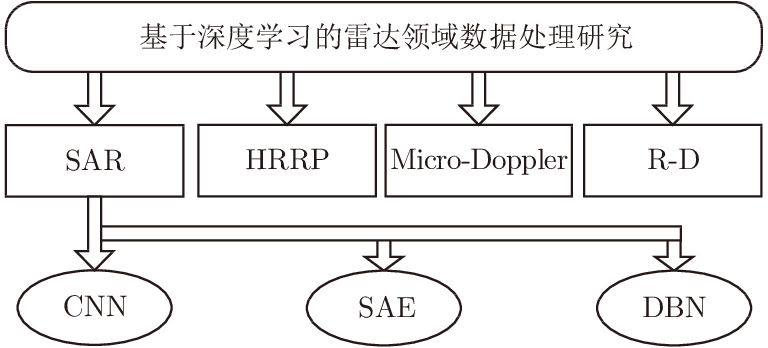
Electromagnetic waves are transmitted by radars and reflected by different objects, and radar signal processing is highly significant as its analyses can lead to the acquisition of important information such as the situation and radial movement speed. Moreover, deep learning has gained much attention in several fields, and it can be utilized to implement radar signal processing. Compared with the traditional methods, deep learning can realize automatic feature extraction and yield highly accurate results; hence, in this paper, the application of deep learning algorithm in radar signal processing is studied. In addition, the study directions in radar signal processing are summarized into overfitting and interpretation. Thus, these two issues are being considered.
Electromagnetic waves are transmitted by radars and reflected by different objects, and radar signal processing is highly significant as its analyses can lead to the acquisition of important information such as the situation and radial movement speed. Moreover, deep learning has gained much attention in several fields, and it can be utilized to implement radar signal processing. Compared with the traditional methods, deep learning can realize automatic feature extraction and yield highly accurate results; hence, in this paper, the application of deep learning algorithm in radar signal processing is studied. In addition, the study directions in radar signal processing are summarized into overfitting and interpretation. Thus, these two issues are being considered.


2018, 7(4): 412-424.
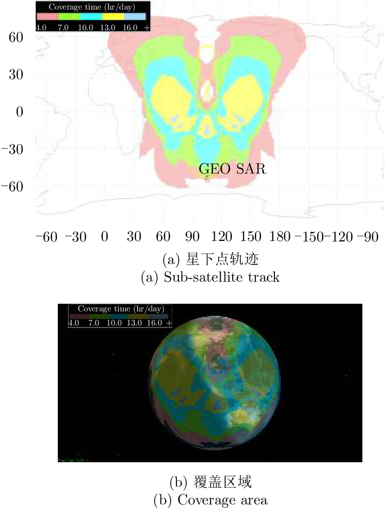
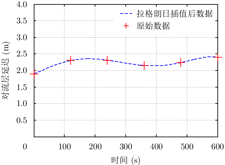
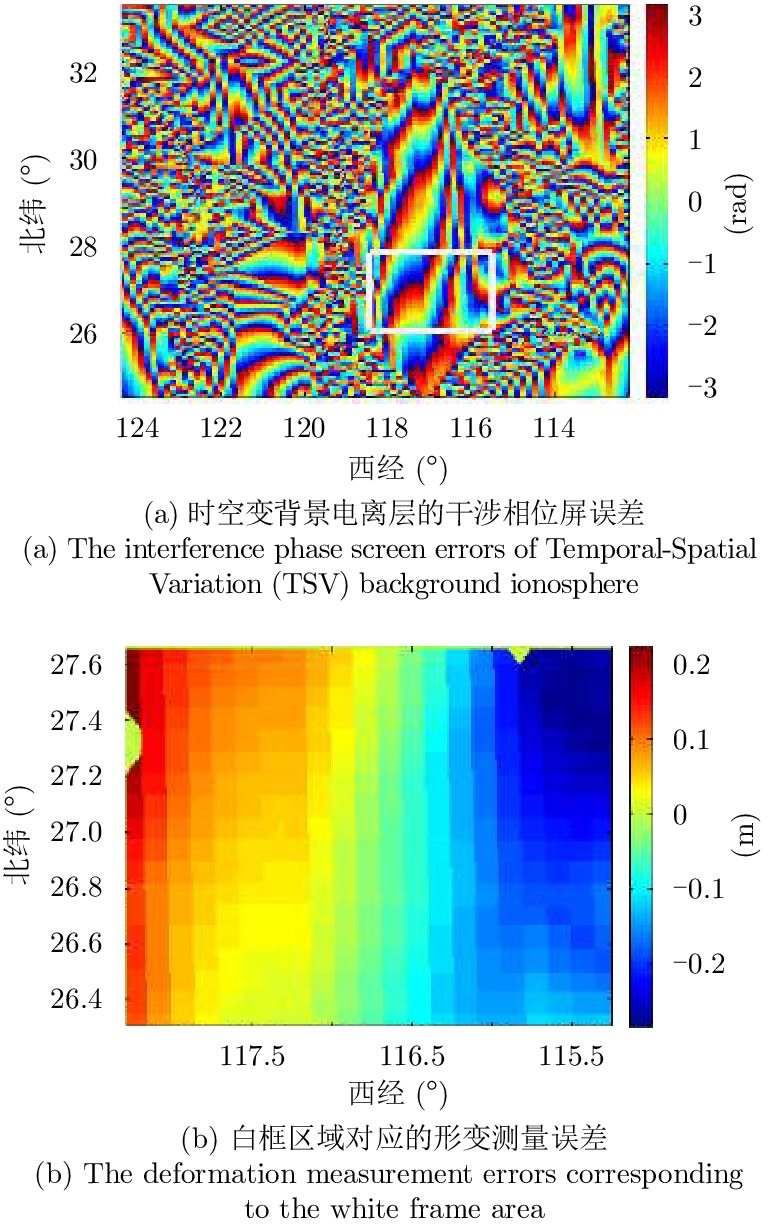
GEOsynchronous orbit Synthetic Aperture Radar (GEO SAR) has a long synthetic aperture and large observation region; therefore, it is easily affected by atmospheric spatial-temporal changes, which results in a serious degradation in the focusing quality and performance of differential interference processing. In this paper, a high-precision spatial-temporal hybrid GEO SAR signal model is established for the slowly disturbed parts of the atmosphere such as the background troposphere and the ionosphere. The effects of the time rate of different atmospheric parameters on the image quality and accuracy of differential interference processing are analyzed. Considering the influence of random disturbances such as tropospheric turbulence and ionospheric scintillation in atmosphere, a quantitative analysis model is established based on a power law power spectrum model using the atmospheric disturbance and imaging quality parameters. The relationships of the random disturbances intensity in the atmosphere and the imaging evaluation index are obtained. Finally, the model is verified by simulations, and the effects of slow-varying atmospheric errors in a long aperture time on the quality of imaging and differential interference processing are analyzed. Simulation results show that spatial-temporal variable ionospheric disturbances seriously affect L-band GEO SAR imaging and differential interference processing, which must be compensated, and they are slightly affected by tropospheric disturbances. Moreover, it is necessary to consider the tropospheric effects on imaging performance only when the integration time reaches several hundred seconds.
GEOsynchronous orbit Synthetic Aperture Radar (GEO SAR) has a long synthetic aperture and large observation region; therefore, it is easily affected by atmospheric spatial-temporal changes, which results in a serious degradation in the focusing quality and performance of differential interference processing. In this paper, a high-precision spatial-temporal hybrid GEO SAR signal model is established for the slowly disturbed parts of the atmosphere such as the background troposphere and the ionosphere. The effects of the time rate of different atmospheric parameters on the image quality and accuracy of differential interference processing are analyzed. Considering the influence of random disturbances such as tropospheric turbulence and ionospheric scintillation in atmosphere, a quantitative analysis model is established based on a power law power spectrum model using the atmospheric disturbance and imaging quality parameters. The relationships of the random disturbances intensity in the atmosphere and the imaging evaluation index are obtained. Finally, the model is verified by simulations, and the effects of slow-varying atmospheric errors in a long aperture time on the quality of imaging and differential interference processing are analyzed. Simulation results show that spatial-temporal variable ionospheric disturbances seriously affect L-band GEO SAR imaging and differential interference processing, which must be compensated, and they are slightly affected by tropospheric disturbances. Moreover, it is necessary to consider the tropospheric effects on imaging performance only when the integration time reaches several hundred seconds.


2018, 7(4): 425-436.
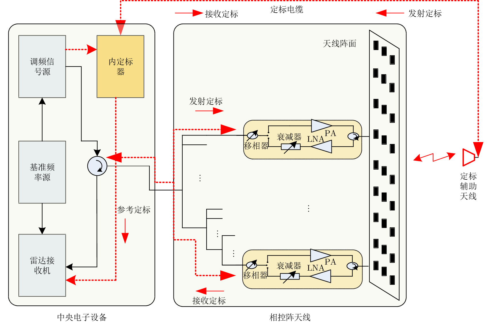
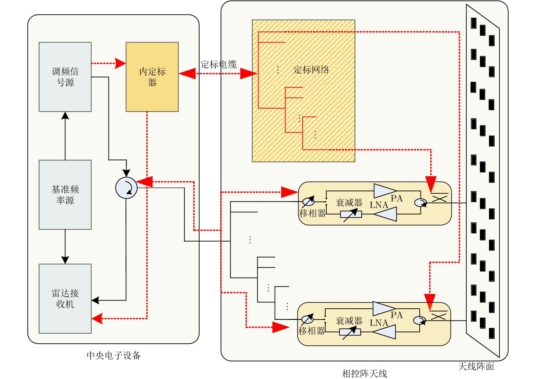
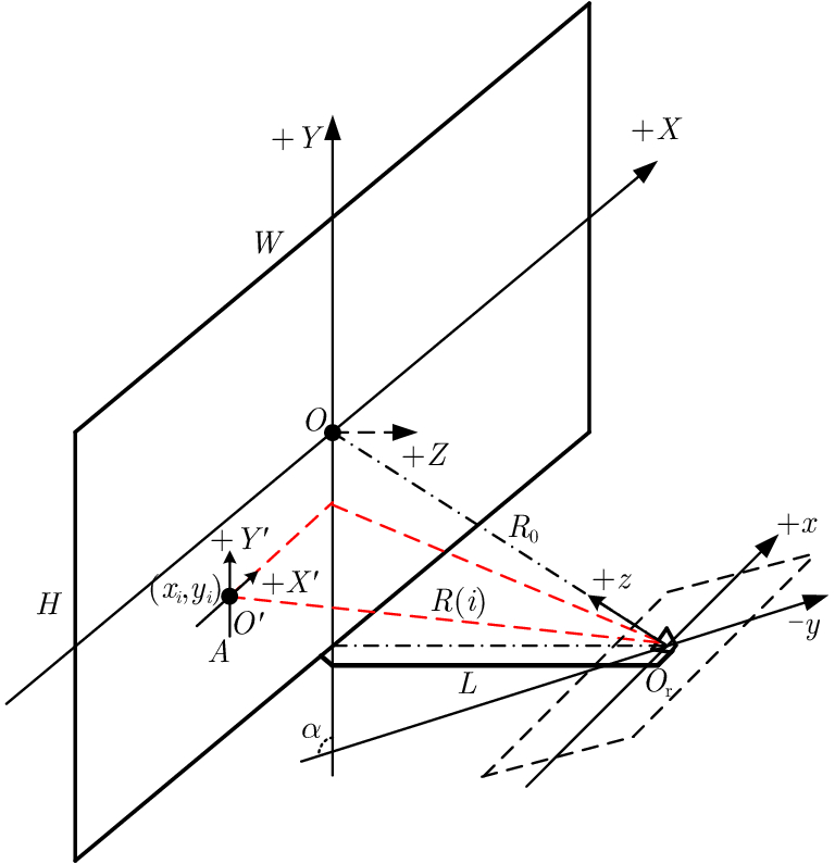
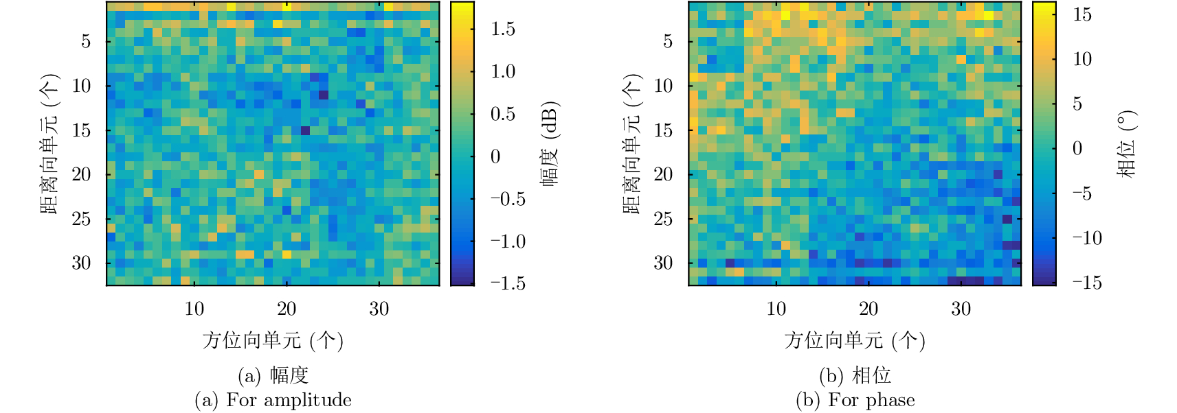
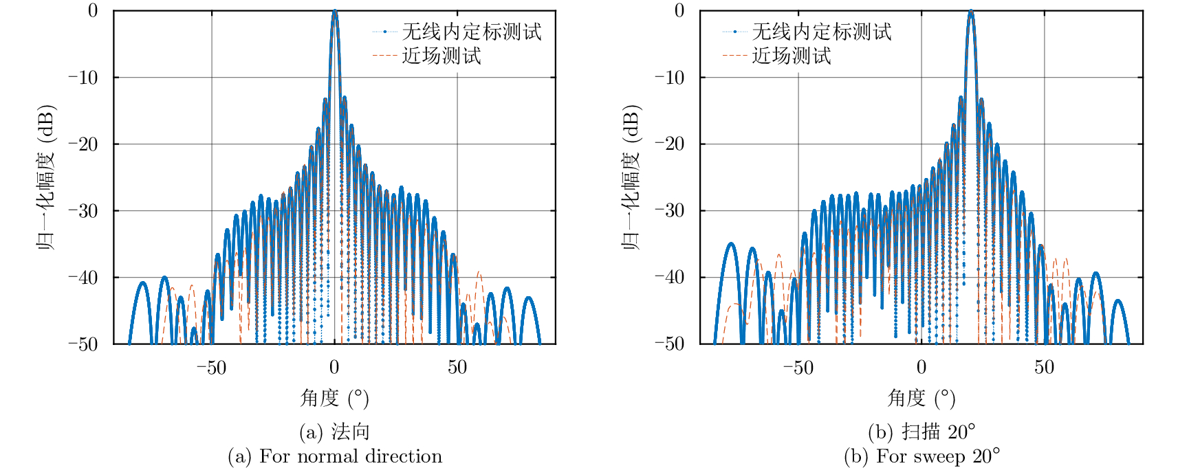
Internal calibration measures the changes in amplitude and phase of a system during imaging via the calibration loop built in Synthetic Aperture Radar (SAR). Internal calibration is also an important factor to improve the radiation accuracy of the radar. In this study, a novel wireless internal calibration method with auxiliary antenna is presented, considering that the traditional scheme is inefficient, as the calibration loop cannot cover the path from the TR (Transmitter-Receiver) output to the antenna radiator. The calibration loop also results in a complicated and heavy network. The principle and model of the new method is given, and the TR performance and system transfer function calibration approach are deduced. In addition, error analysis is conducted. The simulation results show that TR amplitude calibration errors caused by the rod of auxiliary antenna are at a 10–3 dB level, and phase calibration errors are obtained from the simulation curve in the paper; transfer function amplitude calibration errors are less than 0.1 dB, and phase calibration errors are not sensitive to the bias of the rod. Finally, the simulation results based on typical parameters of spaceborne SAR and the individual TR calibration experiments confirm the availability and feasibility of this novel method.
Internal calibration measures the changes in amplitude and phase of a system during imaging via the calibration loop built in Synthetic Aperture Radar (SAR). Internal calibration is also an important factor to improve the radiation accuracy of the radar. In this study, a novel wireless internal calibration method with auxiliary antenna is presented, considering that the traditional scheme is inefficient, as the calibration loop cannot cover the path from the TR (Transmitter-Receiver) output to the antenna radiator. The calibration loop also results in a complicated and heavy network. The principle and model of the new method is given, and the TR performance and system transfer function calibration approach are deduced. In addition, error analysis is conducted. The simulation results show that TR amplitude calibration errors caused by the rod of auxiliary antenna are at a 10–3 dB level, and phase calibration errors are obtained from the simulation curve in the paper; transfer function amplitude calibration errors are less than 0.1 dB, and phase calibration errors are not sensitive to the bias of the rod. Finally, the simulation results based on typical parameters of spaceborne SAR and the individual TR calibration experiments confirm the availability and feasibility of this novel method.


2018, 7(4): 437-445.
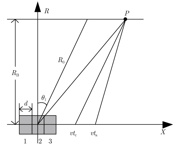
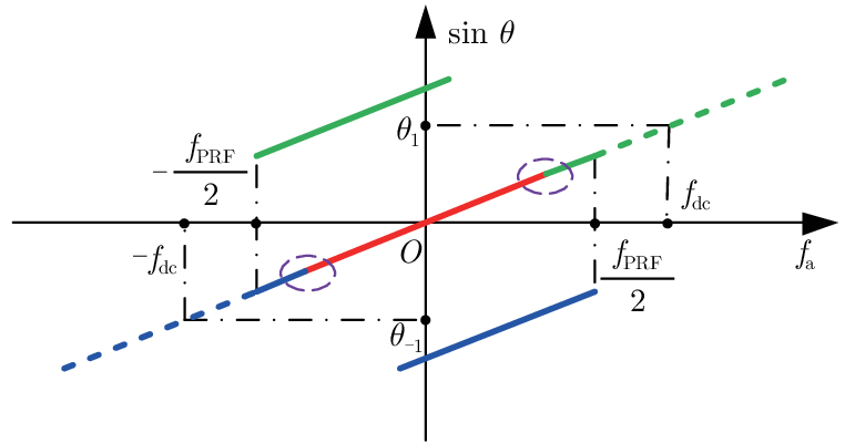
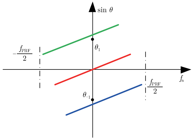
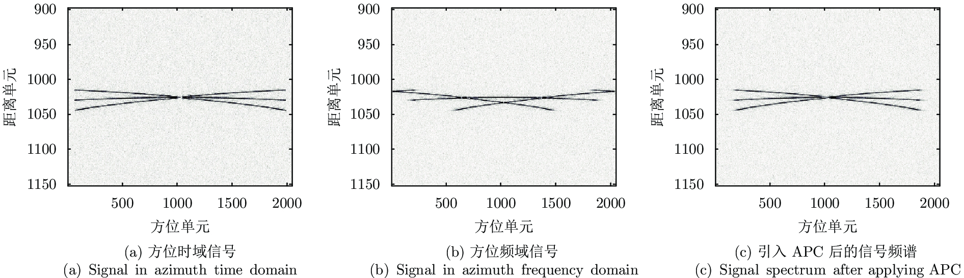
The intra-pulse spotlight imaging mode can effectively overcome the contradiction between high resolution and wide swath in spaceborne Synthetic Aperture Radar (SAR), and considers the echo’s signal-to-noise ratio. However, signal division by spatial filtering along the range direction may be impacted by fluctuating terrain. To solve this problem, a novel intra-pulse spotlight imaging method based on Azimuth Phase Coding (APC) is proposed in this paper. Using APC, the azimuth spectrum of echo data from different sub-pulses will locate in different Pulse Repetition Frequencies (PRF). As such, the signal can be divided using an azimuth adaptive beamforming technique. The signal separation method and selection of the shift factor are discussed in detail. Finally, simulation results demonstrate the effectiveness of the proposed method.
The intra-pulse spotlight imaging mode can effectively overcome the contradiction between high resolution and wide swath in spaceborne Synthetic Aperture Radar (SAR), and considers the echo’s signal-to-noise ratio. However, signal division by spatial filtering along the range direction may be impacted by fluctuating terrain. To solve this problem, a novel intra-pulse spotlight imaging method based on Azimuth Phase Coding (APC) is proposed in this paper. Using APC, the azimuth spectrum of echo data from different sub-pulses will locate in different Pulse Repetition Frequencies (PRF). As such, the signal can be divided using an azimuth adaptive beamforming technique. The signal separation method and selection of the shift factor are discussed in detail. Finally, simulation results demonstrate the effectiveness of the proposed method.


2018, 7(4): 446-454.
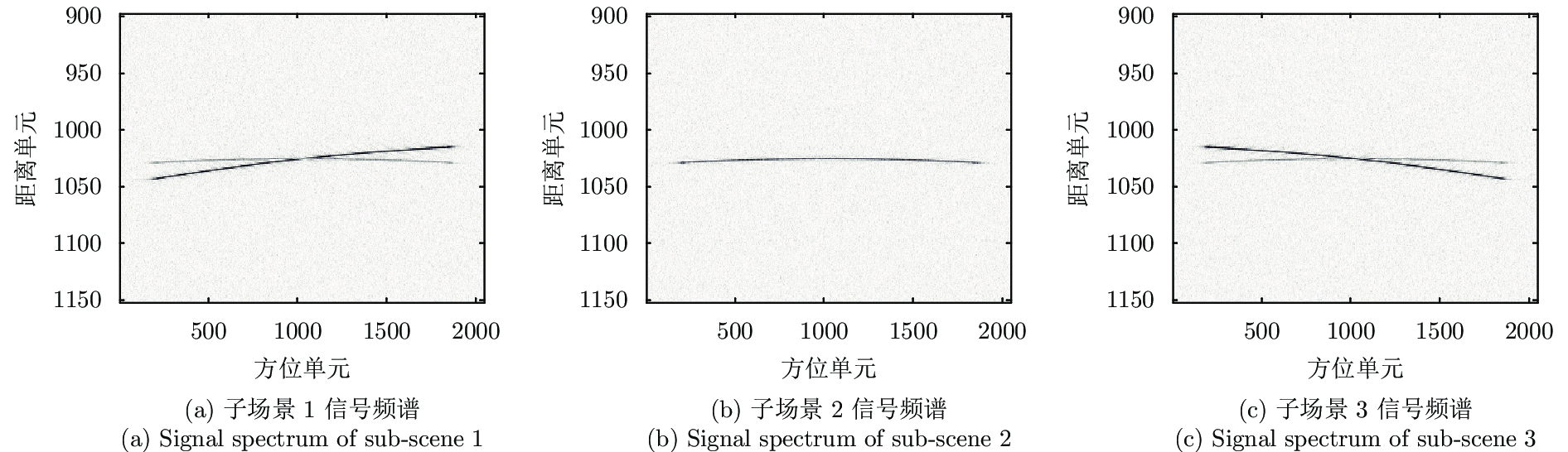
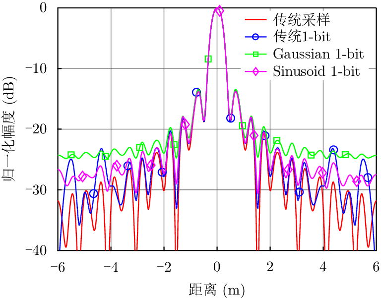
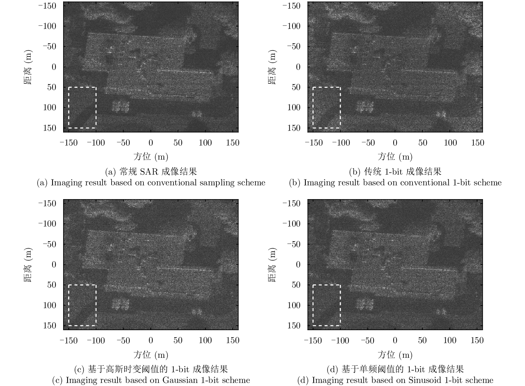
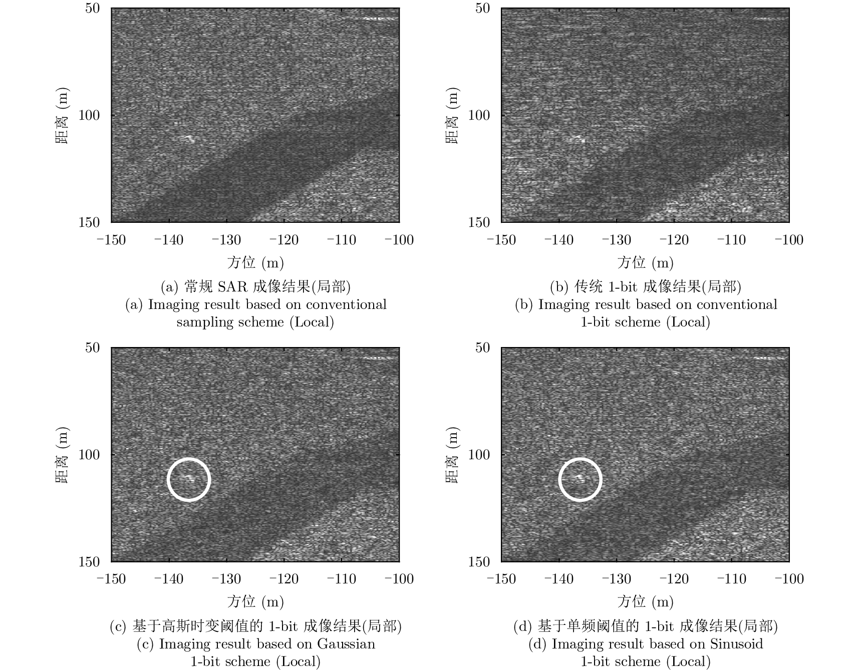
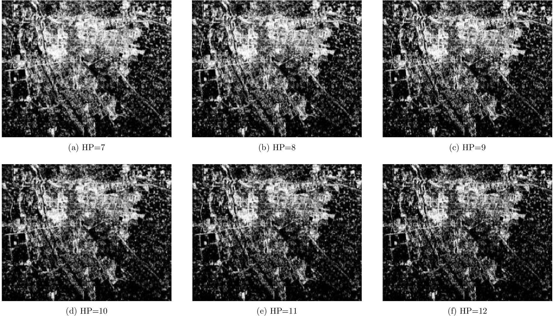
This paper proposes a 1-bit Synthetic Aperture Radar (SAR) imaging method based on a single-frequency time-varying threshold. Synthetic aperture radar echoes are quantized to 1-bit sampling data by comparing the data with the threshold; this reduces the data-width of the SAR echoes, consequently simplifying the system and improving efficiency. The conventional 1-bit sampling compares the signal to a zero threshold, bringing nonlinear distortion to the relative amplitude and degrading the imaging quality. The random threshold can keep the amplitude information, but it introduces additional noise-like interferences. In contrary, the single-frequency time-varying threshold can maintain the amplitude information lost during the 1-bit sampling and quantization, and at the same time, eliminate noise-like interferences; thus, the imaging quality of SAR using 1-bit sampling and quantization can be improved. The focusing quality and the amplitude-maintaining ability of the proposed approach is quantitatively analyzed, and the effectiveness of the approach is verified by an imaging experiment on a scene.
This paper proposes a 1-bit Synthetic Aperture Radar (SAR) imaging method based on a single-frequency time-varying threshold. Synthetic aperture radar echoes are quantized to 1-bit sampling data by comparing the data with the threshold; this reduces the data-width of the SAR echoes, consequently simplifying the system and improving efficiency. The conventional 1-bit sampling compares the signal to a zero threshold, bringing nonlinear distortion to the relative amplitude and degrading the imaging quality. The random threshold can keep the amplitude information, but it introduces additional noise-like interferences. In contrary, the single-frequency time-varying threshold can maintain the amplitude information lost during the 1-bit sampling and quantization, and at the same time, eliminate noise-like interferences; thus, the imaging quality of SAR using 1-bit sampling and quantization can be improved. The focusing quality and the amplitude-maintaining ability of the proposed approach is quantitatively analyzed, and the effectiveness of the approach is verified by an imaging experiment on a scene.


2018, 7(4): 455-464.
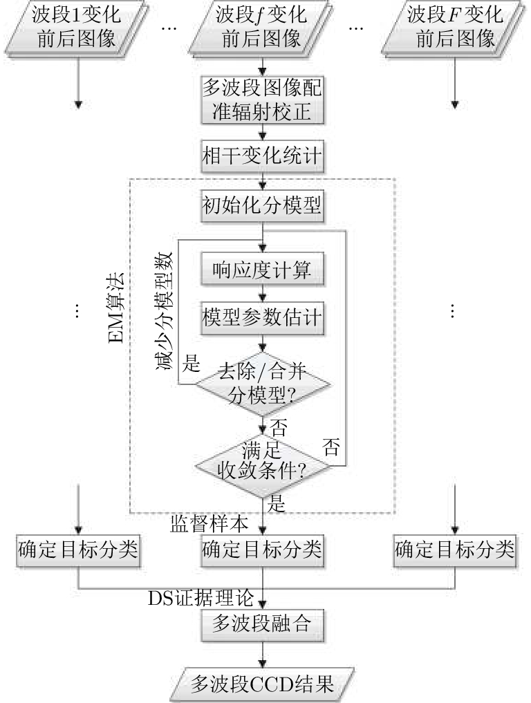
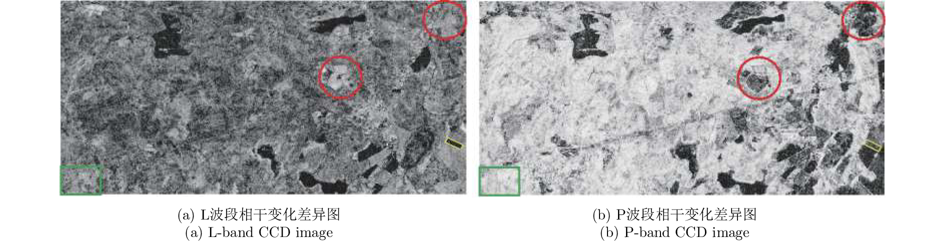
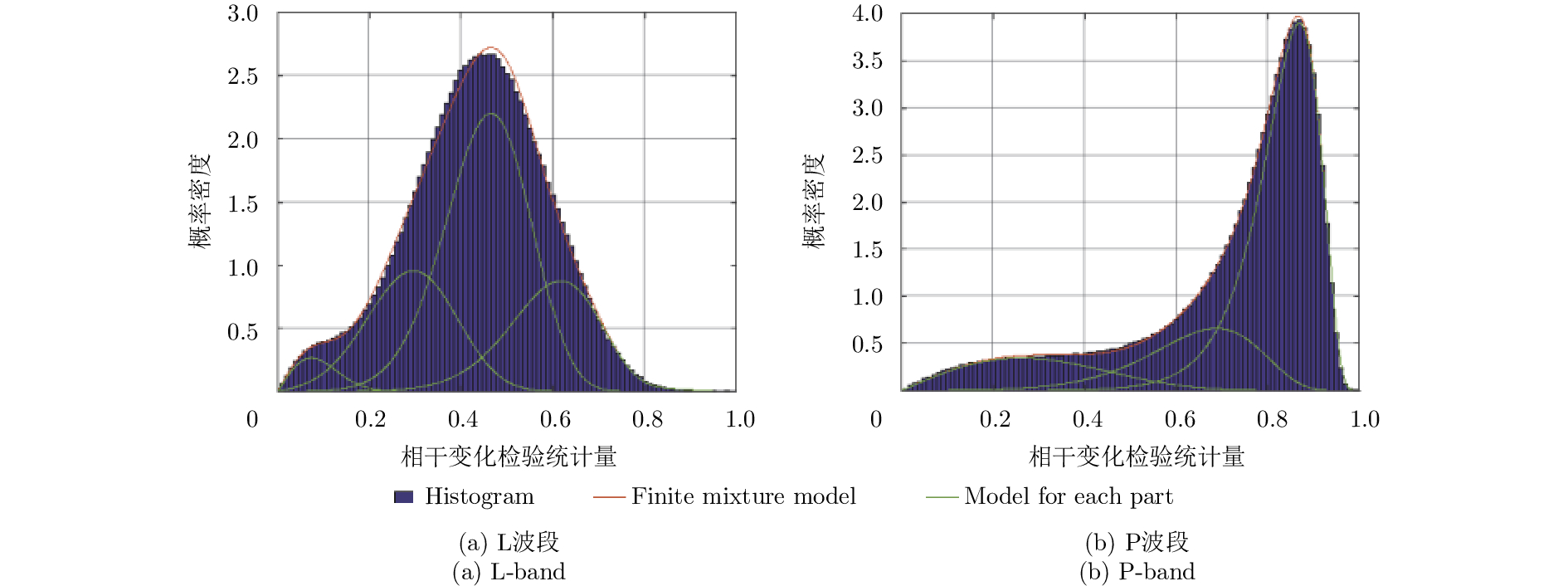
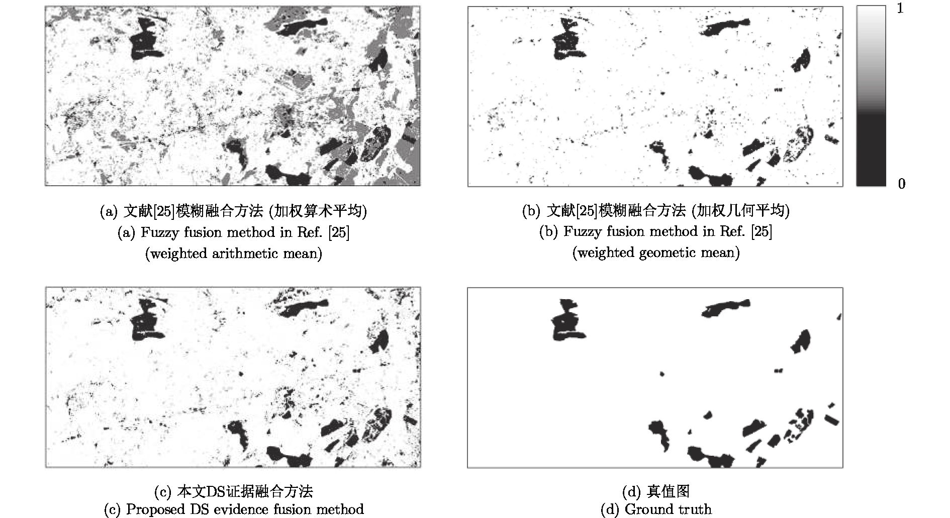
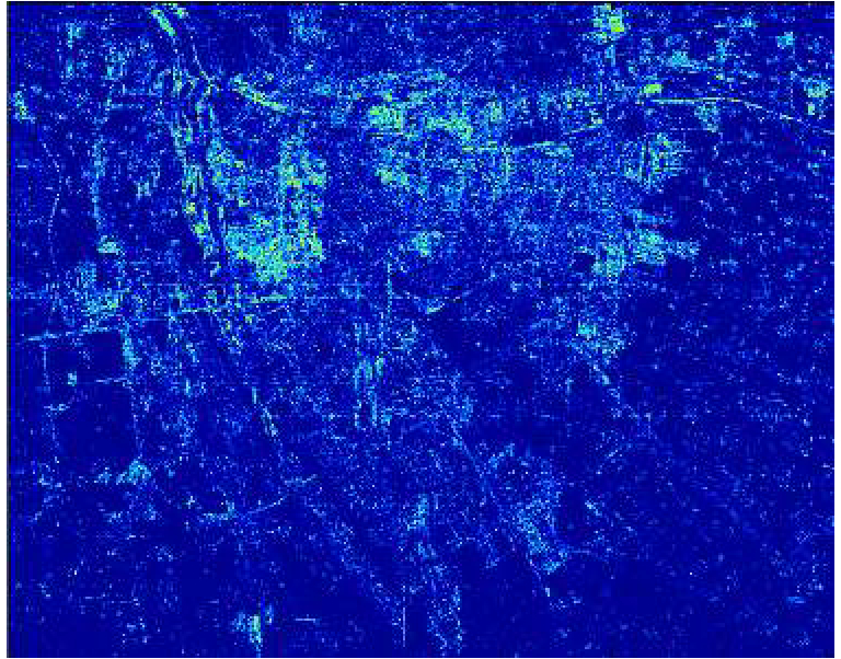
Coherent Change Detection (CCD) detects micro changes in a scene using phase coherence of SAR images before and after a change. It is difficult for conventional CCD method to distinguish low coherence interference region from objective change region because of a single detection scale. Multi-band SAR target detection in a multiscale way develops variable coherent representation according to the diversity of electromagnetic wave penetration, target structure, and change magnitude. In this paper, a multi-band CCD method is proposed. Firstly, the CCD images of every band were acquired; secondly, the detected scene was classified on the basis of coherent representation of targets in each single band using improved Expectation-Maximization (EM) algorithm; thirdly, the objective change class in each single band was selected by a few supervised samples; lastly, multi-band fusion CCD image was acquired by the use of Dempster-Shafer (DS) evidence theory. This multi-band CCD result can eliminate low coherent interference in each single band and decrease false alarm probability. The method is validated by L- and P-band repeat-pass SAR images acquired before and after change. Results and index parameters demonstrate the validity and correctness of the proposed method.
Coherent Change Detection (CCD) detects micro changes in a scene using phase coherence of SAR images before and after a change. It is difficult for conventional CCD method to distinguish low coherence interference region from objective change region because of a single detection scale. Multi-band SAR target detection in a multiscale way develops variable coherent representation according to the diversity of electromagnetic wave penetration, target structure, and change magnitude. In this paper, a multi-band CCD method is proposed. Firstly, the CCD images of every band were acquired; secondly, the detected scene was classified on the basis of coherent representation of targets in each single band using improved Expectation-Maximization (EM) algorithm; thirdly, the objective change class in each single band was selected by a few supervised samples; lastly, multi-band fusion CCD image was acquired by the use of Dempster-Shafer (DS) evidence theory. This multi-band CCD result can eliminate low coherent interference in each single band and decrease false alarm probability. The method is validated by L- and P-band repeat-pass SAR images acquired before and after change. Results and index parameters demonstrate the validity and correctness of the proposed method.


2018, 7(4): 465-474.
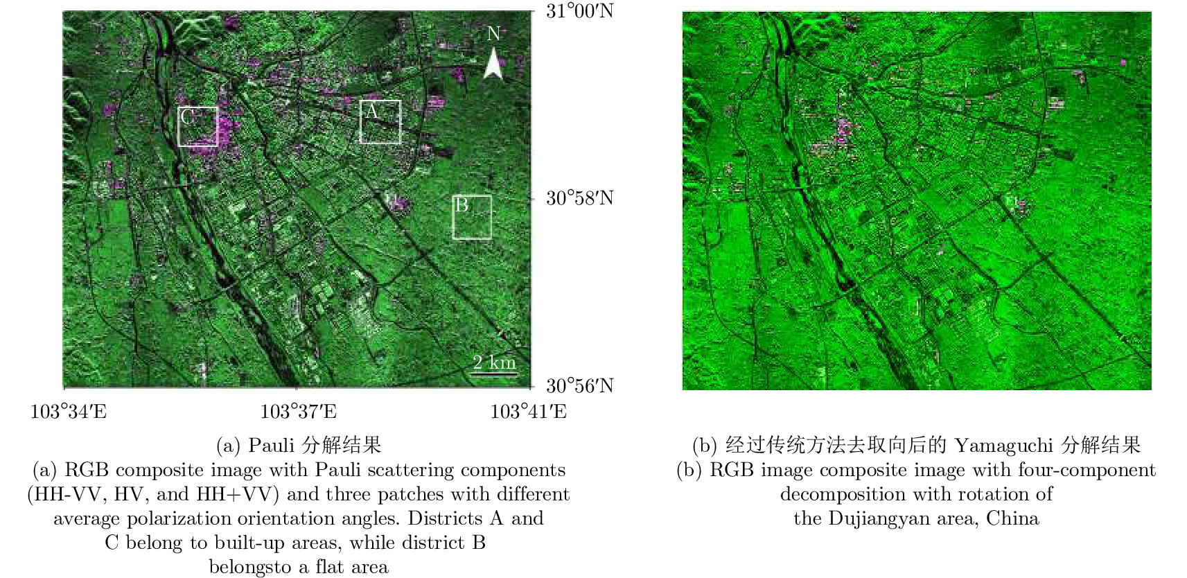
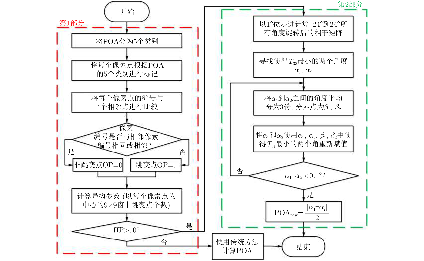
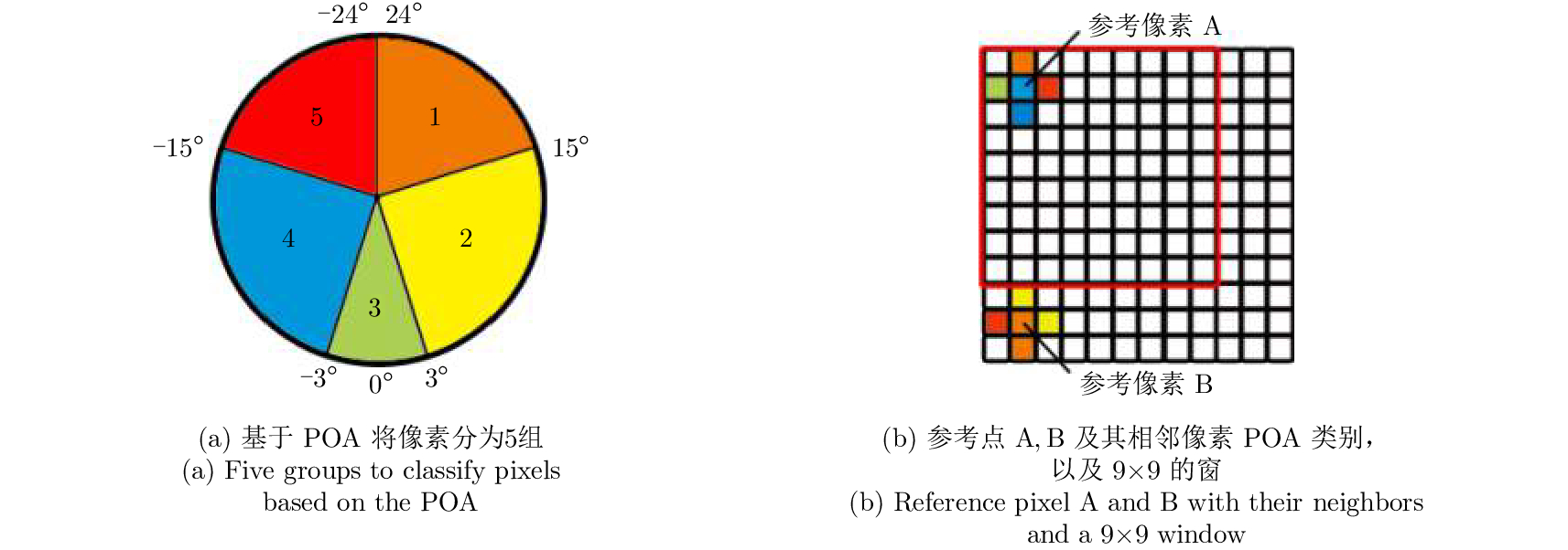
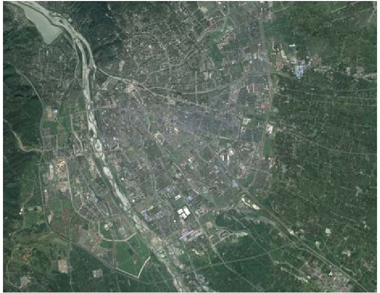
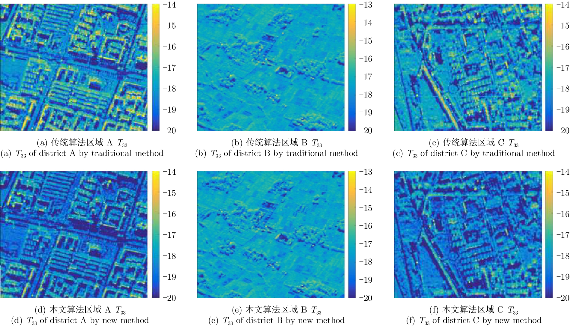
Polarimetric decomposition in urban areas is important for monitoring the speed of city expansion and studying its ecological environmental influence. Using fully Polarimetric Synthetic Aperture Radar (PolSAR) is a method for consistent observation of large-range urban changes. In the last two decades, most research on decomposition methods have stated that Polarization Orientation Angle (POA) would affect the results of decomposition by overestimating the volume scattering contribution of urban areas. The available deorientation methods cannot rotate built-up areas with large POAs. This paper proposes an algorithm for decomposition of high-resolution urban area images based on a POA correction method. First, for high-resolution images of built-up areas, the POA changes radically pixel by pixel. An approximate assessment of urban areas can be accomplished using POA randomness. Then, to search for the true POA of large dominant POA areas (most built-up regions), the linear approximation method is used to locate POAs that can minimize cross-polarized terms. Thereby, the inaccurate decomposition that occurs by the deviation of POA can be fixed, and the accuracy of results improves. The fully PolSAR data of the Dujiangyan area in Sichuan Province, China are used to confirm the algorithm’s effectiveness. The data are acquired by an X-band airborne SAR sensor designed by the Institute of Electronics, China Academy of Sciences (IECAS).
Polarimetric decomposition in urban areas is important for monitoring the speed of city expansion and studying its ecological environmental influence. Using fully Polarimetric Synthetic Aperture Radar (PolSAR) is a method for consistent observation of large-range urban changes. In the last two decades, most research on decomposition methods have stated that Polarization Orientation Angle (POA) would affect the results of decomposition by overestimating the volume scattering contribution of urban areas. The available deorientation methods cannot rotate built-up areas with large POAs. This paper proposes an algorithm for decomposition of high-resolution urban area images based on a POA correction method. First, for high-resolution images of built-up areas, the POA changes radically pixel by pixel. An approximate assessment of urban areas can be accomplished using POA randomness. Then, to search for the true POA of large dominant POA areas (most built-up regions), the linear approximation method is used to locate POAs that can minimize cross-polarized terms. Thereby, the inaccurate decomposition that occurs by the deviation of POA can be fixed, and the accuracy of results improves. The fully PolSAR data of the Dujiangyan area in Sichuan Province, China are used to confirm the algorithm’s effectiveness. The data are acquired by an X-band airborne SAR sensor designed by the Institute of Electronics, China Academy of Sciences (IECAS).


2018, 7(4): 475-486.
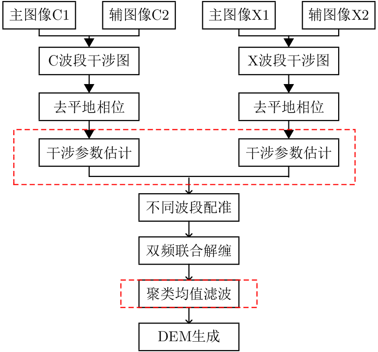
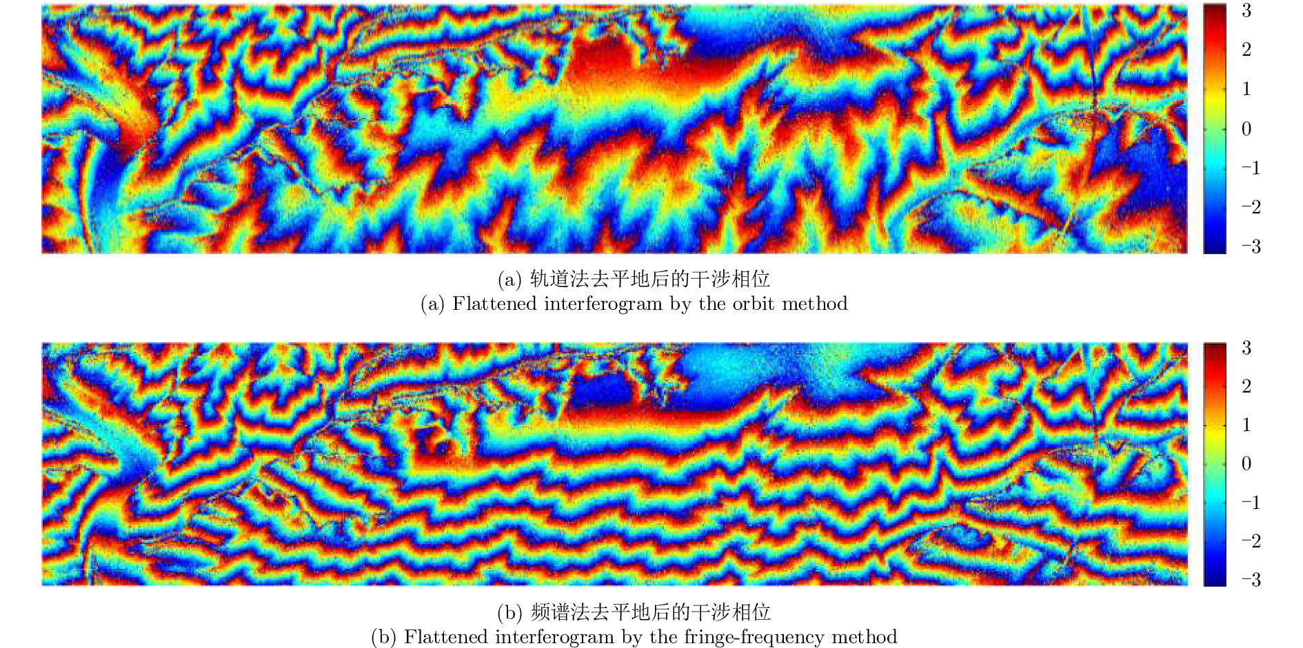
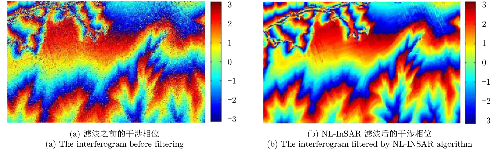
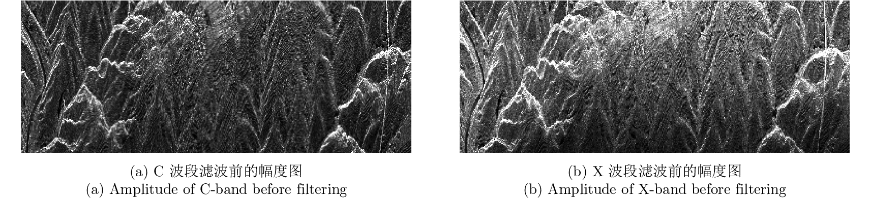
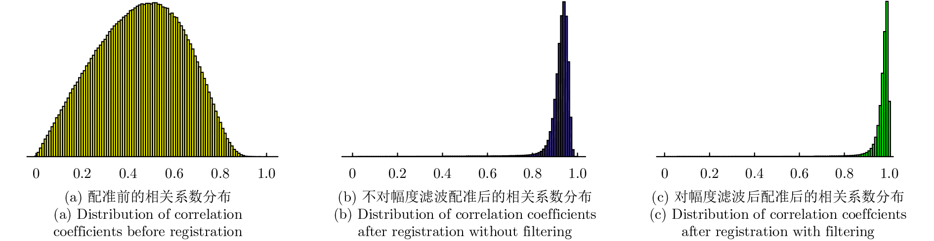
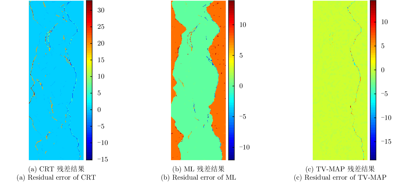
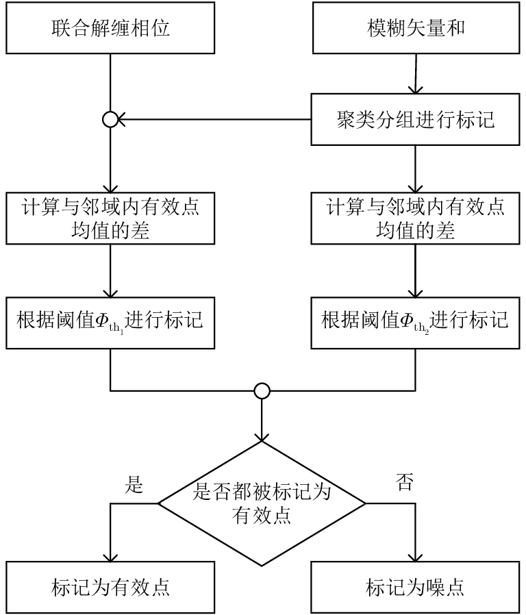
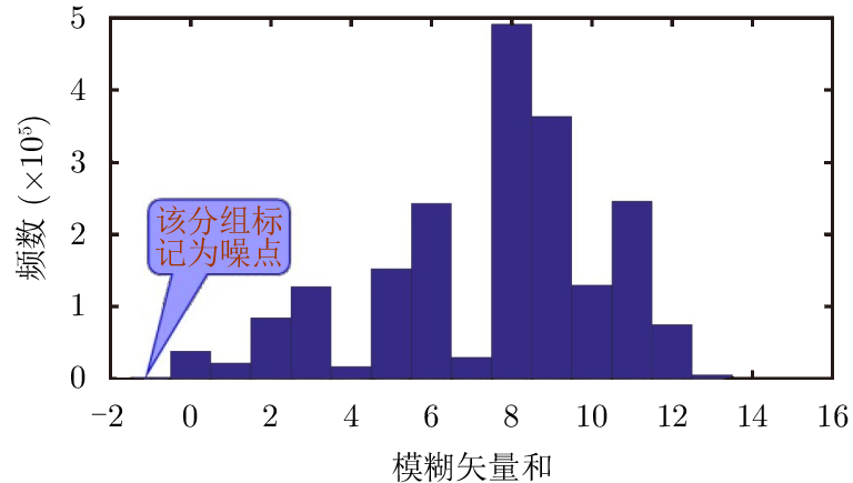
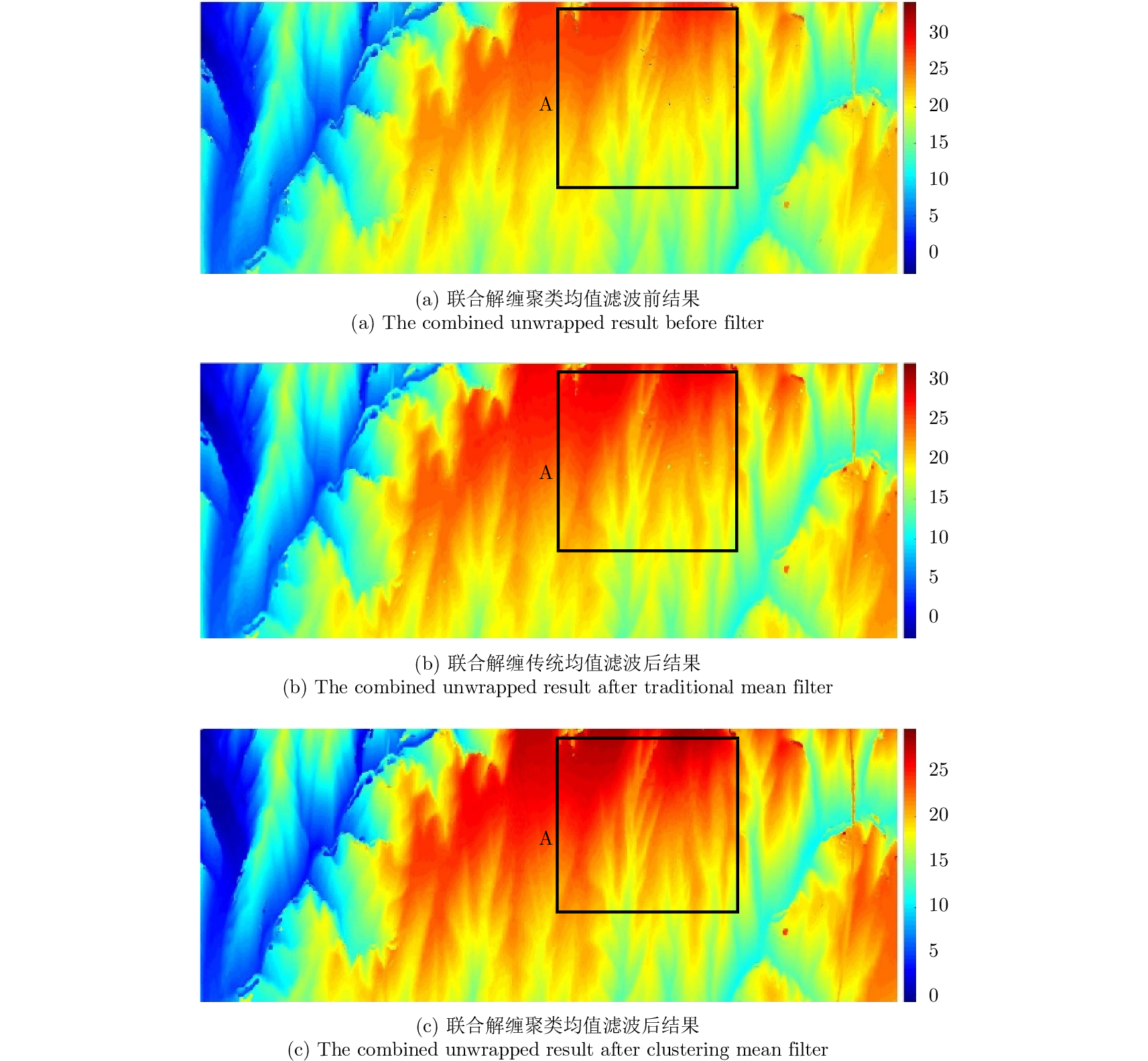
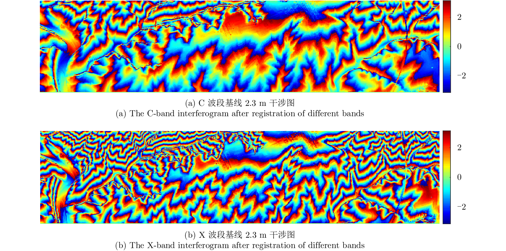
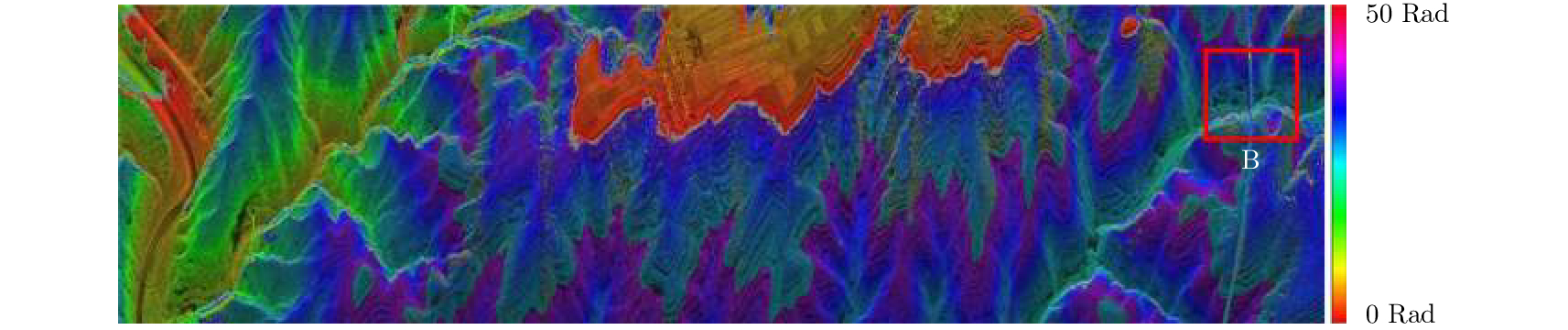
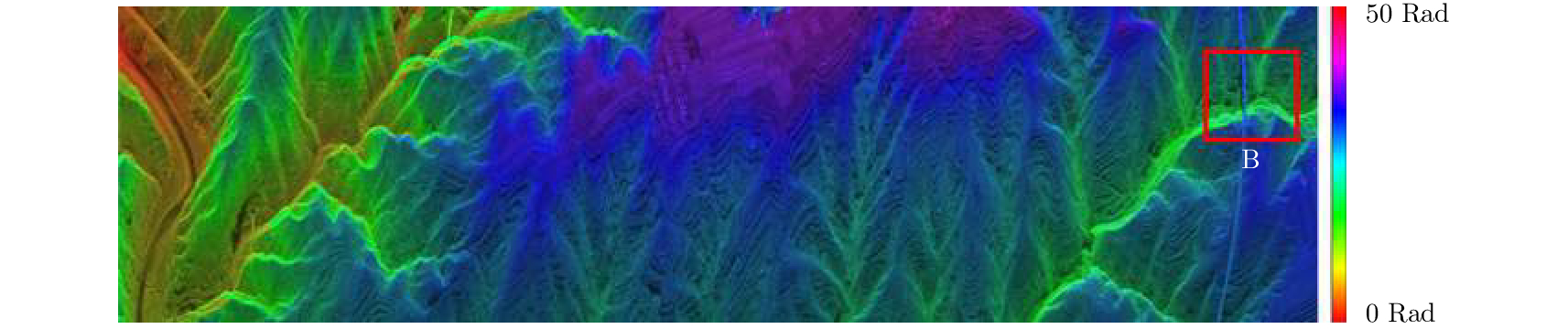
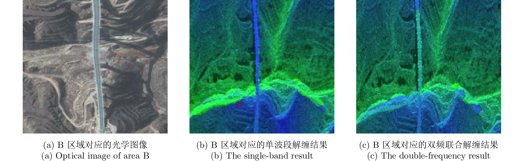
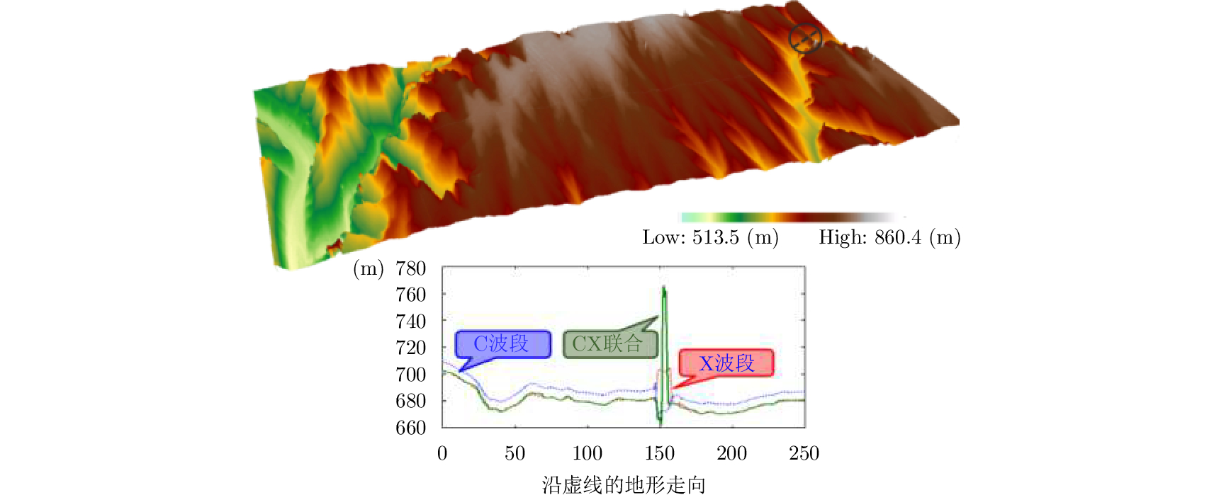
Dual-frequency joint phase unwrapping does not need to satisfy the Iton hypothesis, so dual-frequency interferometry can effectively extract elevation information from large terrain undulation areas. This paper presents an effective method for Dual-Frequency Interferometry (DFI) SAR terrain elevation reconstruction, aiming at the low precision of elevation reconstruction in DFI processing. This method improves the key steps in the conventional process. Firstly, Nonlocal Interferogram Estimation (NL-InSAR) technique is used to accurately estimate amplitude map, coherence coefficient, and Interferometric phase before the registration in different bands. After filtering, the filtered amplitude information of each band is used to realize the registration of Interferometric phase in different bands. Then clustering analysis technique is used to mark the effective points and noise points of unwrapping phase, and these effective points are used to filter the mean value of joint phase unwrapping. The airborne measured data used in the experiment include the complex data of C band and X band main and auxiliary SAR images of the same scene. In view of the measured data processing, the proposed method provides better results of elevation reconstruction.
Dual-frequency joint phase unwrapping does not need to satisfy the Iton hypothesis, so dual-frequency interferometry can effectively extract elevation information from large terrain undulation areas. This paper presents an effective method for Dual-Frequency Interferometry (DFI) SAR terrain elevation reconstruction, aiming at the low precision of elevation reconstruction in DFI processing. This method improves the key steps in the conventional process. Firstly, Nonlocal Interferogram Estimation (NL-InSAR) technique is used to accurately estimate amplitude map, coherence coefficient, and Interferometric phase before the registration in different bands. After filtering, the filtered amplitude information of each band is used to realize the registration of Interferometric phase in different bands. Then clustering analysis technique is used to mark the effective points and noise points of unwrapping phase, and these effective points are used to filter the mean value of joint phase unwrapping. The airborne measured data used in the experiment include the complex data of C band and X band main and auxiliary SAR images of the same scene. In view of the measured data processing, the proposed method provides better results of elevation reconstruction.


2018, 7(4): 487-497.
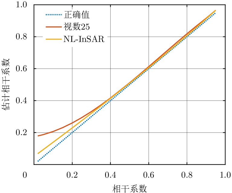
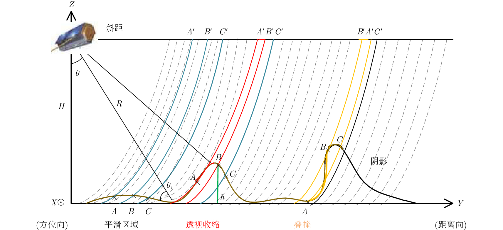
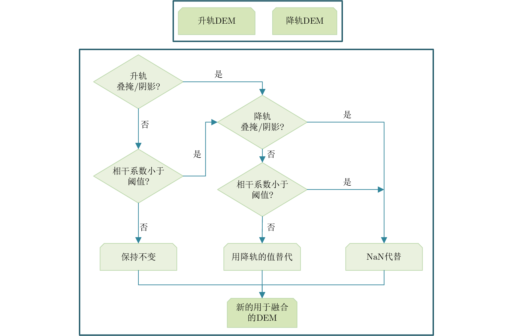
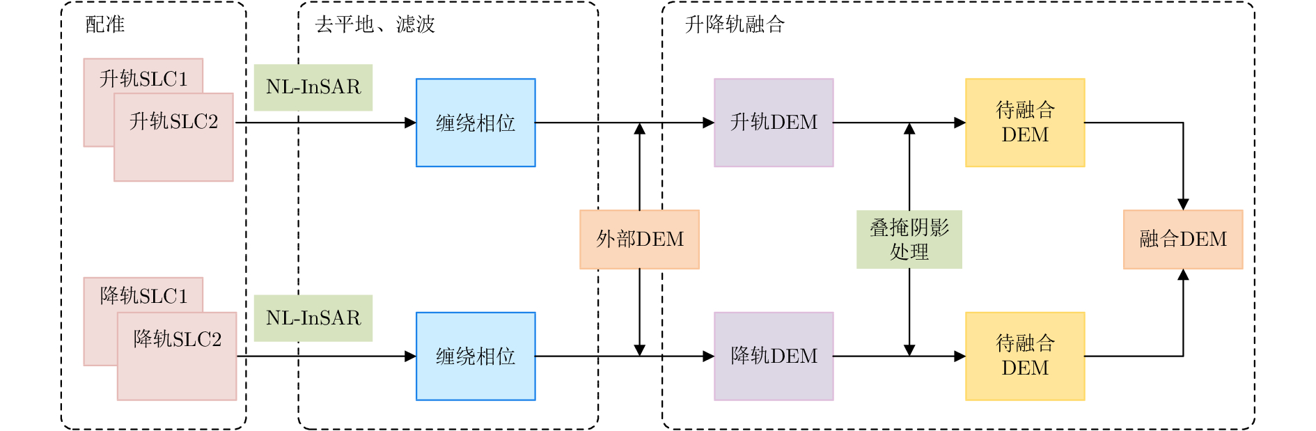
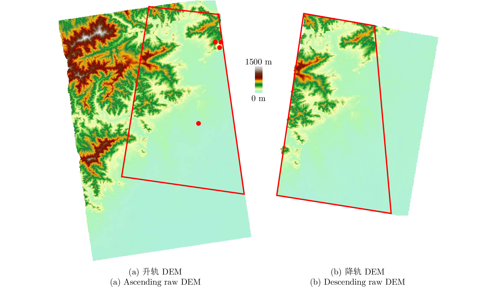
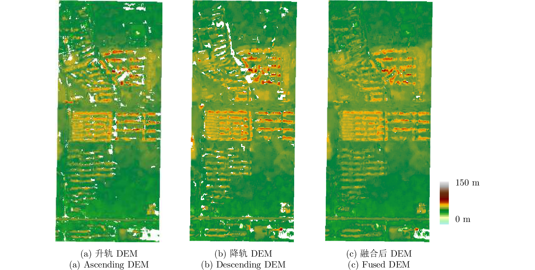
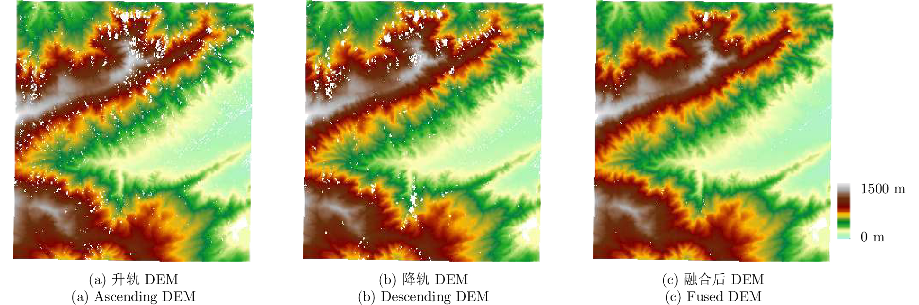
A method for fine resolution and high precision Digital Elevation Model (DEM) generation using ascending and descending pass TerraSAR-X/TanDEM-X (TSX/TDX) datasets is proposed in this study. First, the NonLocal Interferometric SAR (NL-InSAR) can effectively generate ascending and descending pass raw DEMs. On this basis, the coherence well recovered by NL-InSAR is used to fusion the raw DEMs to further improve the accuracy and reduce the invalids caused by layover and shadows. This method was used to process the TSX/TDX data obtained in Beijing. The number of invalid points of DEM after fusion decreased significantly. Statistics result shows that it decreased from 4.93% in ascending raw DEM and 4.52% in descending raw DEM to 1.34% in the fusion DEM. At the same time, the accuracy of the fusion DEM increased by 9.6% compared to 6.67 m in the descending raw DEM and 8.7% compared to 6.74 m in the ascending raw DEM, reaching 6.09 m.
A method for fine resolution and high precision Digital Elevation Model (DEM) generation using ascending and descending pass TerraSAR-X/TanDEM-X (TSX/TDX) datasets is proposed in this study. First, the NonLocal Interferometric SAR (NL-InSAR) can effectively generate ascending and descending pass raw DEMs. On this basis, the coherence well recovered by NL-InSAR is used to fusion the raw DEMs to further improve the accuracy and reduce the invalids caused by layover and shadows. This method was used to process the TSX/TDX data obtained in Beijing. The number of invalid points of DEM after fusion decreased significantly. Statistics result shows that it decreased from 4.93% in ascending raw DEM and 4.52% in descending raw DEM to 1.34% in the fusion DEM. At the same time, the accuracy of the fusion DEM increased by 9.6% compared to 6.67 m in the descending raw DEM and 8.7% compared to 6.74 m in the ascending raw DEM, reaching 6.09 m.


2018, 7(4): 498-506.
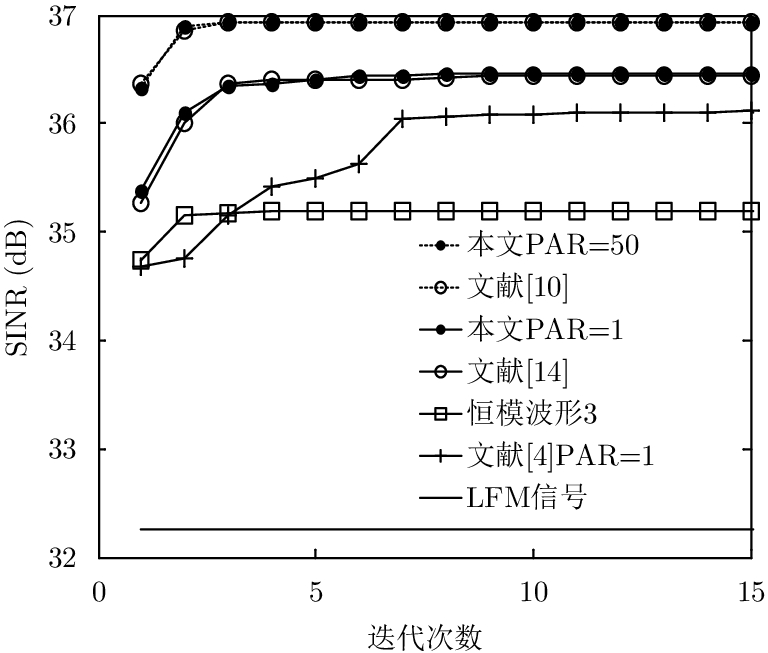
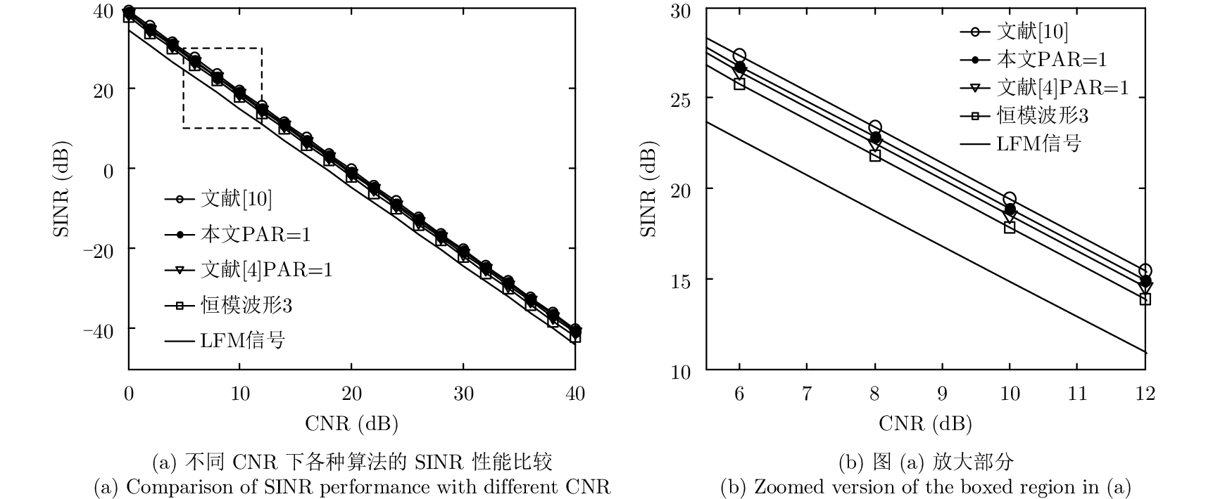
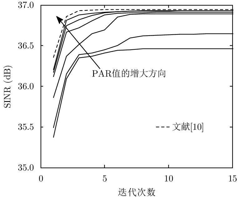
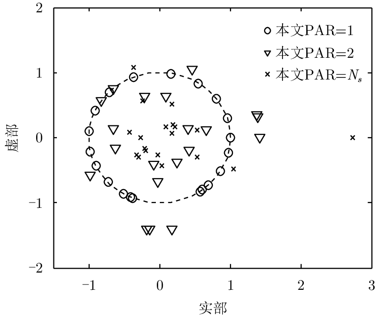
To improve the detection performance of the radar transmit waveform while enabling the transmitter to perform at its maximal efficiency, a joint design method is proposed for the transmit and receive filter in the presence of signal-dependent clutter with a Peak-to-Average-power Ratio (PAR) constraint of the transmit waveform. First, an optimized model of the radar’s output Signal-to-Interference-plus-Noise Ratio (SINR) for range-extended target detection is established. Second, the analytic expression of the receiver is obtained by converting the optimization problem into the Rayleigh quotient model. The optimal matrix solution is then obtained by transforming the non-convex problem into a convex problem via the semi-definite matrix of the waveform. Finally, the optimal vector solution of the waveform is extracted from the optimal matrix solution by combining the rank-one approximation method combined with the nearest neighbor method. An optimal waveform with a maximal output SINR for a given PAR range is obtained using the proposed method. The SINR value of the waveform when PAR = 2 is the same as the SINR value of the optimized waveform under the energy constraint and is about 0.5 dB higher than the waveform when PAR = 1. Simulation results demonstrate the effectiveness of the proposed method.
To improve the detection performance of the radar transmit waveform while enabling the transmitter to perform at its maximal efficiency, a joint design method is proposed for the transmit and receive filter in the presence of signal-dependent clutter with a Peak-to-Average-power Ratio (PAR) constraint of the transmit waveform. First, an optimized model of the radar’s output Signal-to-Interference-plus-Noise Ratio (SINR) for range-extended target detection is established. Second, the analytic expression of the receiver is obtained by converting the optimization problem into the Rayleigh quotient model. The optimal matrix solution is then obtained by transforming the non-convex problem into a convex problem via the semi-definite matrix of the waveform. Finally, the optimal vector solution of the waveform is extracted from the optimal matrix solution by combining the rank-one approximation method combined with the nearest neighbor method. An optimal waveform with a maximal output SINR for a given PAR range is obtained using the proposed method. The SINR value of the waveform when PAR = 2 is the same as the SINR value of the optimized waveform under the energy constraint and is about 0.5 dB higher than the waveform when PAR = 1. Simulation results demonstrate the effectiveness of the proposed method.


2018, 7(4): 507-513.
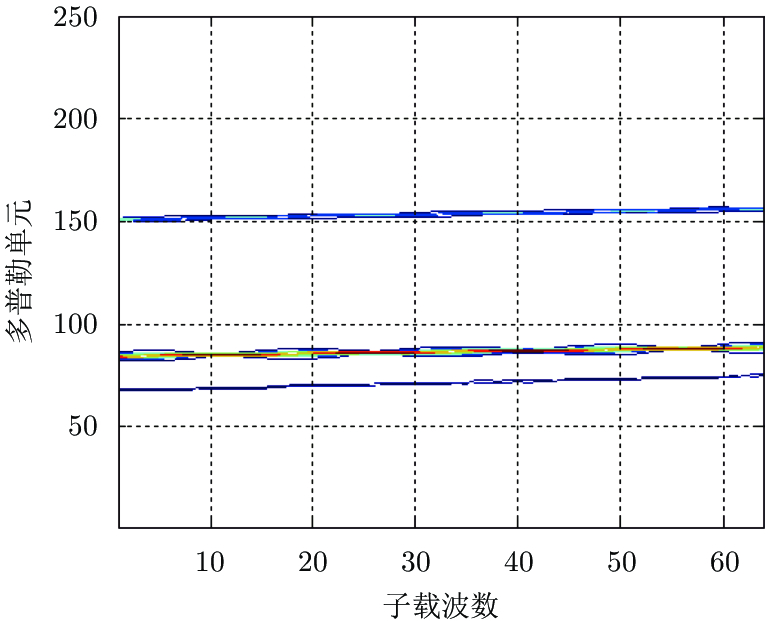
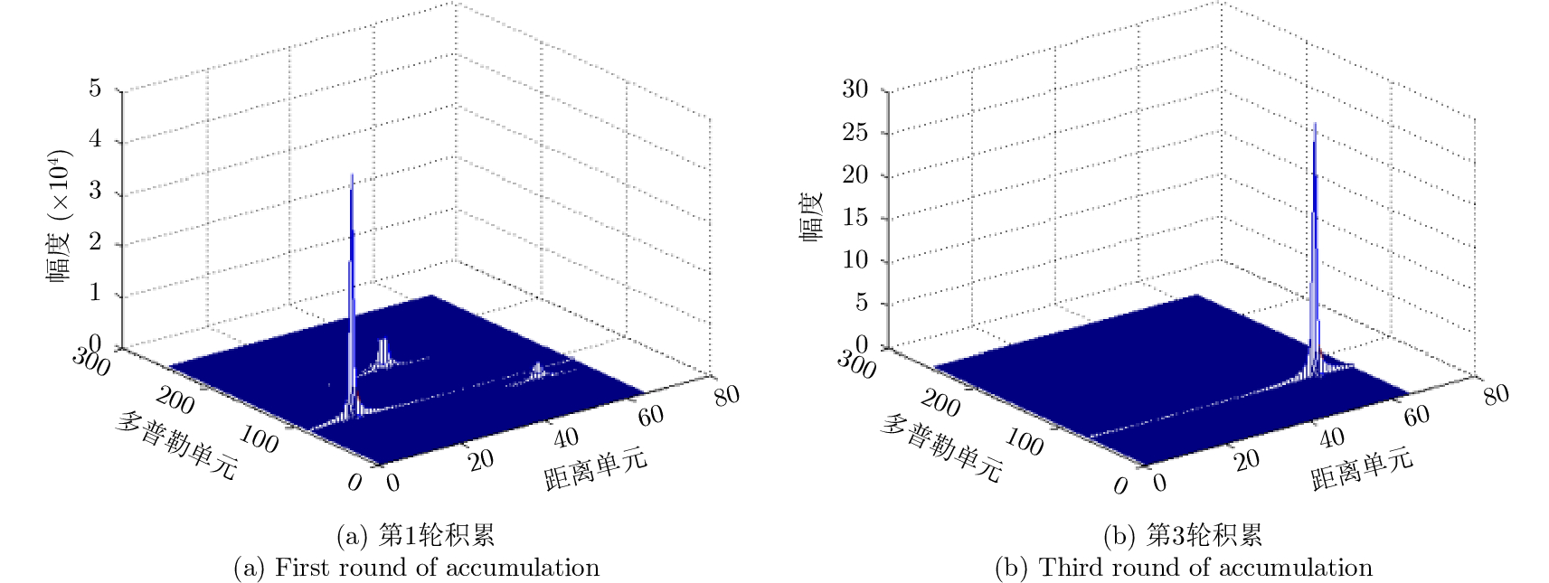
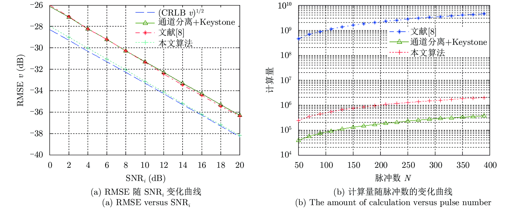
To detect multiple targets on a phase-coded Orthogonal Frequency Division Multiplexing (OFDM) radar, this paper proposes a parameter estimation method based on channel separation and maximum likelihood principle. First, the multi-channel signals were separated because of the orthogonality of the OFDM system, and then the separated signals were correlated with the phase-coded reference signal in the fast time domain to acquire a 1-D range profile from each channel. Subsequently, Keystone transform was used to correct the effect of the coupling between Doppler shift of the subcarrier and the slow time domain. Simultaneously, coherent accumulation was conducted jointly in the slow time and subcarrier domains to obtain a 2-D range-Doppler spectrum. Using CLEAN technique, the peaks of this spectrum were examined to obtain the range cells and velocities of each target. Using these parameters as the initial values, the likelihood function was maximized using Newton’s iterative algorithm to yield an approximate maximum likelihood estimator of the motion parameters. Simulation results demonstrate that the proposed algorithm outperforms the traditional Keystone-based estimation algorithm both in computational complexity and parameter estimation accuracy. The algorithm improved the input SNR by approximately 4 dB under the same root mean square error, and the mean square error approached the Cramer-Rao lower bound.
To detect multiple targets on a phase-coded Orthogonal Frequency Division Multiplexing (OFDM) radar, this paper proposes a parameter estimation method based on channel separation and maximum likelihood principle. First, the multi-channel signals were separated because of the orthogonality of the OFDM system, and then the separated signals were correlated with the phase-coded reference signal in the fast time domain to acquire a 1-D range profile from each channel. Subsequently, Keystone transform was used to correct the effect of the coupling between Doppler shift of the subcarrier and the slow time domain. Simultaneously, coherent accumulation was conducted jointly in the slow time and subcarrier domains to obtain a 2-D range-Doppler spectrum. Using CLEAN technique, the peaks of this spectrum were examined to obtain the range cells and velocities of each target. Using these parameters as the initial values, the likelihood function was maximized using Newton’s iterative algorithm to yield an approximate maximum likelihood estimator of the motion parameters. Simulation results demonstrate that the proposed algorithm outperforms the traditional Keystone-based estimation algorithm both in computational complexity and parameter estimation accuracy. The algorithm improved the input SNR by approximately 4 dB under the same root mean square error, and the mean square error approached the Cramer-Rao lower bound.


2018, 7(4): 514-522.
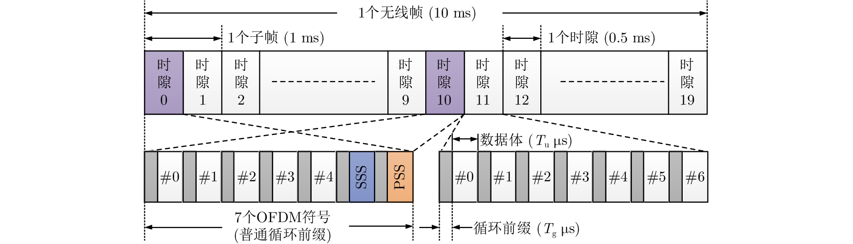
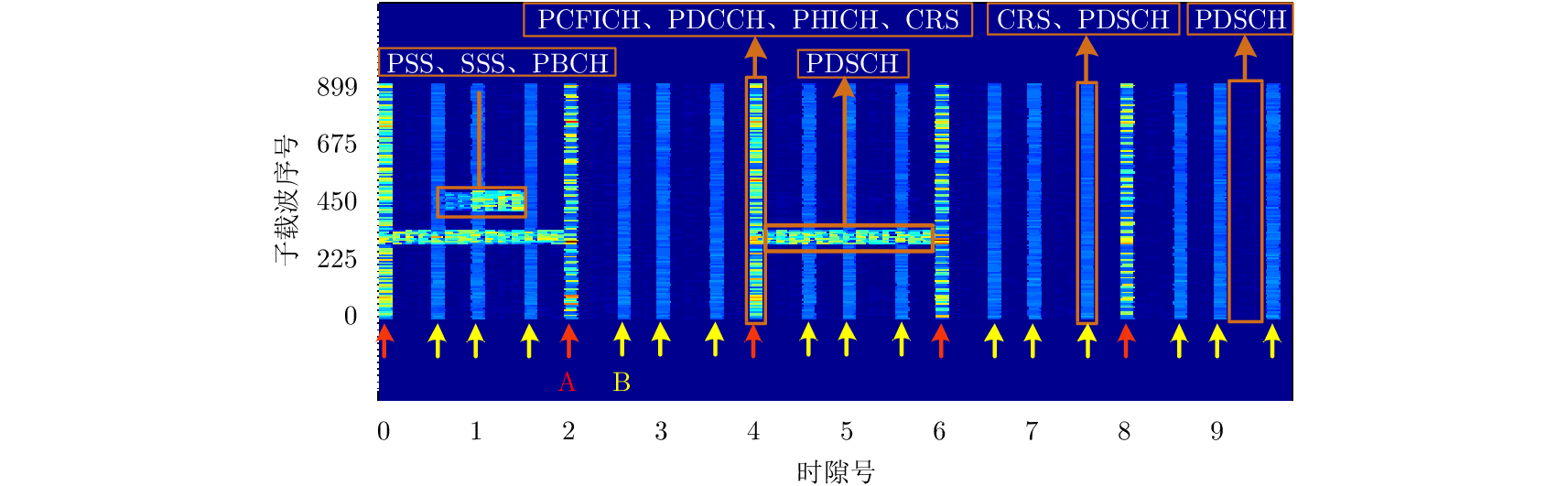
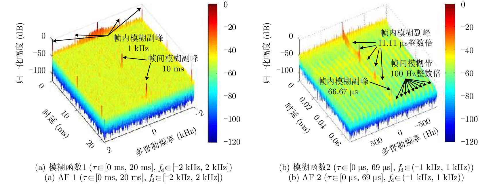
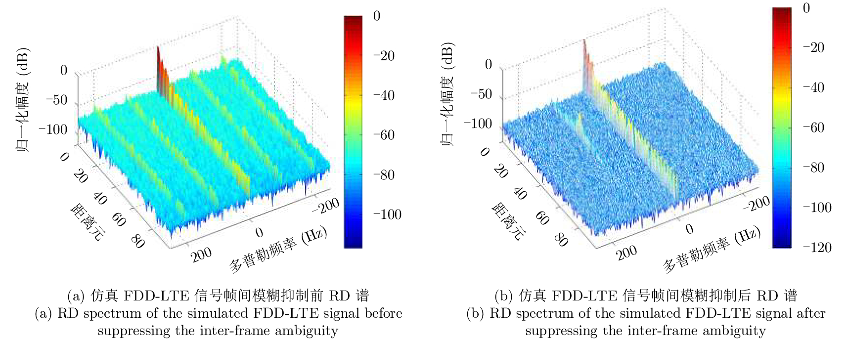
Long Term Evolution (LTE) is a new type of illuminators of opportunity for passive radars, with the advantages of broad bandwidth, high coverage, and strong generality. In this paper, the ambiguity function of Frequency Division Duplexing Long Term Evolution (FDD-LTE) signal is analyzed as an illuminator of opportunity. According to the measured signal, it was found that it is necessary to suppress the inter-frame ambiguity strips in the ambiguity function. Furthermore, themechanism of these inter-frame ambiguity strips was analyzed in detail, which revealed that the LTE signal frame structure is the main factor that causes these inter-frame ambiguity strips and is the major energy source of coherent integration. Thus, a method based on Orthogonal Frequency Division Multiplexing (OFDM) symbol subcarrier coefficient normalization is proposed to suppress these inter-frame ambiguity strips. Simulation and experimental results show that the method can suppress inter-frame ambiguity strips effectively, but does not affect coherent integration, which is the foundation of target detection.
Long Term Evolution (LTE) is a new type of illuminators of opportunity for passive radars, with the advantages of broad bandwidth, high coverage, and strong generality. In this paper, the ambiguity function of Frequency Division Duplexing Long Term Evolution (FDD-LTE) signal is analyzed as an illuminator of opportunity. According to the measured signal, it was found that it is necessary to suppress the inter-frame ambiguity strips in the ambiguity function. Furthermore, themechanism of these inter-frame ambiguity strips was analyzed in detail, which revealed that the LTE signal frame structure is the main factor that causes these inter-frame ambiguity strips and is the major energy source of coherent integration. Thus, a method based on Orthogonal Frequency Division Multiplexing (OFDM) symbol subcarrier coefficient normalization is proposed to suppress these inter-frame ambiguity strips. Simulation and experimental results show that the method can suppress inter-frame ambiguity strips effectively, but does not affect coherent integration, which is the foundation of target detection.


2018, 7(4): 523-530.
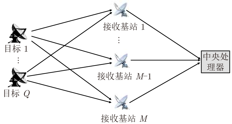
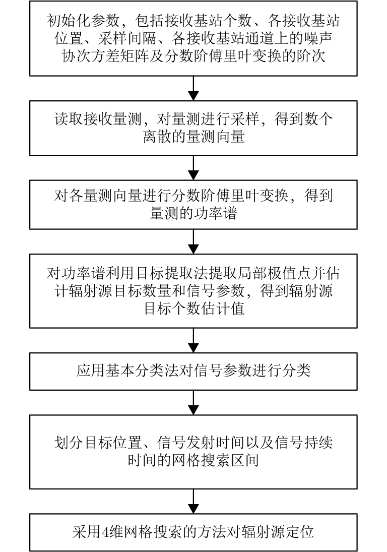
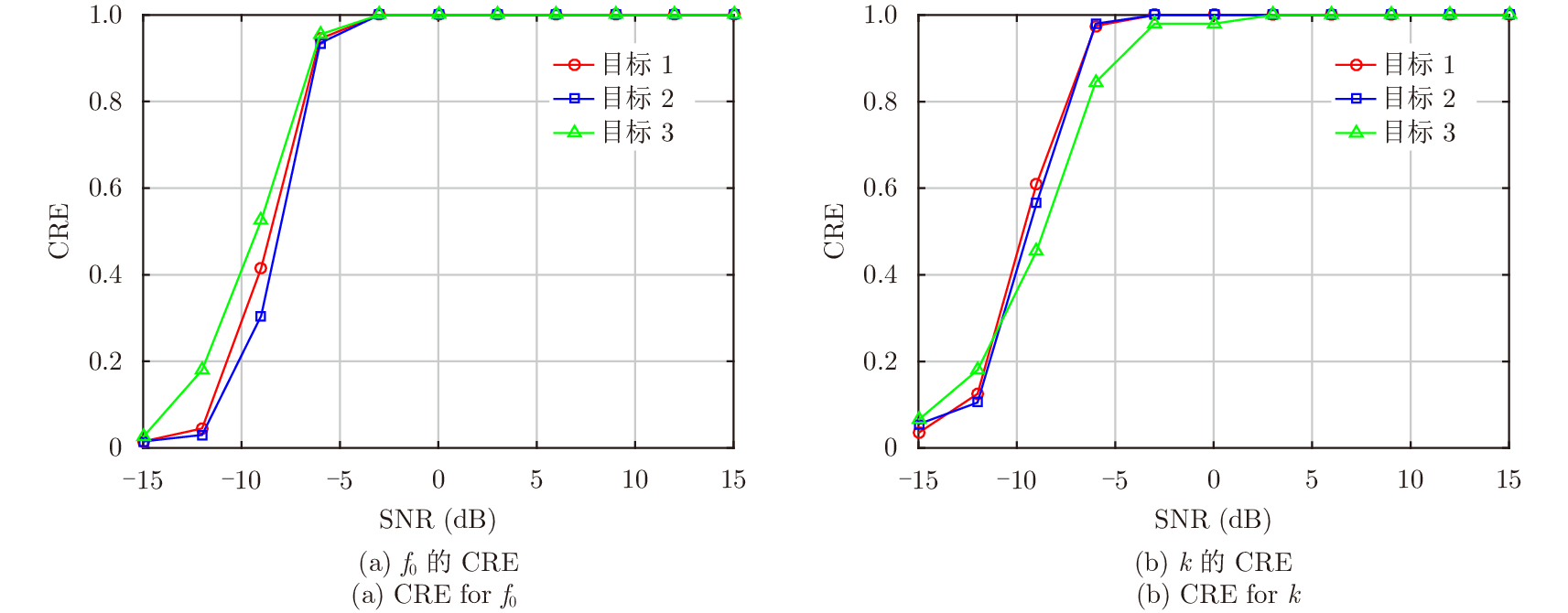
The Direct Position Determination (DPD) method can fully use the information of an observed signal, and it is known to outperform the traditional two-step methods at a low Signal-to-Noise Ratio (SNR). To solve the problem of localizing multiple transmitters with unknown Linear Frequency Modulation (LFM) signals in multi-static passive radar systems, a multi-target positioning algorithm based on DPD algorithm and FRactional Fourier Transform (FRFT) is proposed. First, according to the established signal model, the theoretically optimal high-dimensional maximum likelihood estimator is deduced; Then, to address the high computational complexity of the estimator in jointly estimating high-dimensional signal parameters and positions of sources, we propose a dimensionality reduction strategy based on the FRFT and some basic classification algorithms to transform the multi-target localizing problem to a multiple single-target localizing problem. Through this method, the position and the corresponding signal parameters of each source can be efficiently estimated by a four-dimensional grid search. Simulation results show that the proposed method outperforms the existing DPD algorithm, and it can determine the positions of sources without directly utilizing the transmitted signal information.
The Direct Position Determination (DPD) method can fully use the information of an observed signal, and it is known to outperform the traditional two-step methods at a low Signal-to-Noise Ratio (SNR). To solve the problem of localizing multiple transmitters with unknown Linear Frequency Modulation (LFM) signals in multi-static passive radar systems, a multi-target positioning algorithm based on DPD algorithm and FRactional Fourier Transform (FRFT) is proposed. First, according to the established signal model, the theoretically optimal high-dimensional maximum likelihood estimator is deduced; Then, to address the high computational complexity of the estimator in jointly estimating high-dimensional signal parameters and positions of sources, we propose a dimensionality reduction strategy based on the FRFT and some basic classification algorithms to transform the multi-target localizing problem to a multiple single-target localizing problem. Through this method, the position and the corresponding signal parameters of each source can be efficiently estimated by a four-dimensional grid search. Simulation results show that the proposed method outperforms the existing DPD algorithm, and it can determine the positions of sources without directly utilizing the transmitted signal information.


 微信 | 公众平台

