
 Submit Manuscript
 Peer Review
 Editor Work
- Home
- Articles & Issues
-
Data
- Dataset of Radar Detecting Sea
- SAR Dataset
- SARGroundObjectsTypes
- SARMV3D
- AIRSAT Constellation SAR Land Cover Classification Dataset
- 3DRIED
- UWB-HA4D
- LLS-LFMCWR
- FAIR-CSAR
- MSAR
- SDD-SAR
- FUSAR
- SpaceborneSAR3Dimaging
- Sea-land Segmentation
- SAR Multi-domain Ship Detection Dataset
- SAR-Airport
- Hilly and mountainous farmland time-series SAR and ground quadrat dataset
- SAR images for interference detection and suppression
- HP-SAR Evaluation & Analytical Dataset
- GDHuiYan-ATRNet
- Multi-System Maritime Low Observable Target Dataset
- DatasetinthePaper
- DatasetintheCompetition
- Report
- Course
- About
- Publish
- Editorial Board
- Chinese
| Citation: | Qin Xiaofang, Zhang Huachun, Zhang Heng, Wang Yu, Liu Huayou. A High Precision DEM Generation Method Based on Ascending and Descending Pass TerraSAR-X/TanDEM-X BiSAR Data[J]. Journal of Radars, 2018, 7(4): 487-497. doi: 10.12000/JR18022

|
A High Precision DEM Generation Method Based on Ascending and Descending Pass TerraSAR-X/TanDEM-X BiSAR Data
DOI: 10.12000/JR18022 CSTR: 32380.14.JR18022
-
Abstract
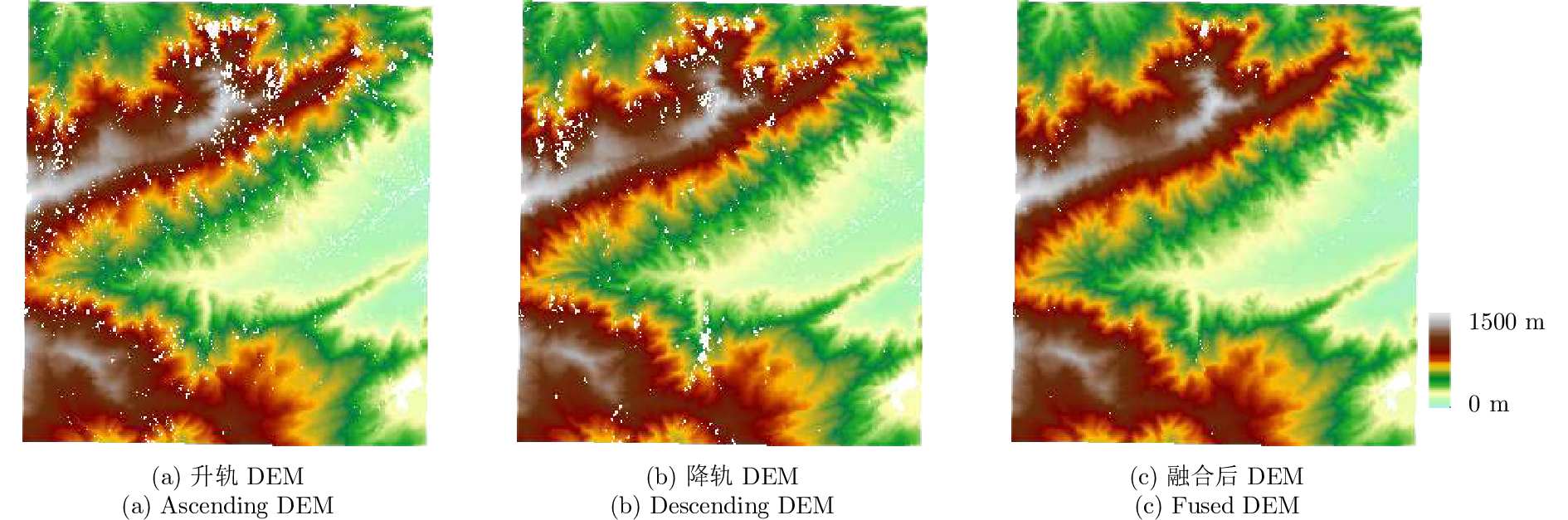
A method for fine resolution and high precision Digital Elevation Model (DEM) generation using ascending and descending pass TerraSAR-X/TanDEM-X (TSX/TDX) datasets is proposed in this study. First, the NonLocal Interferometric SAR (NL-InSAR) can effectively generate ascending and descending pass raw DEMs. On this basis, the coherence well recovered by NL-InSAR is used to fusion the raw DEMs to further improve the accuracy and reduce the invalids caused by layover and shadows. This method was used to process the TSX/TDX data obtained in Beijing. The number of invalid points of DEM after fusion decreased significantly. Statistics result shows that it decreased from 4.93% in ascending raw DEM and 4.52% in descending raw DEM to 1.34% in the fusion DEM. At the same time, the accuracy of the fusion DEM increased by 9.6% compared to 6.67 m in the descending raw DEM and 8.7% compared to 6.74 m in the ascending raw DEM, reaching 6.09 m. -

-
References
[1] 蒋厚军. 高分辨率星载InSAR技术在DEM生成及更新中的应用研究[D]. [博士论文], 武汉大学, 2012: 1–2Jiang Hou-jun. High-resolution spaceborne SAR interferometry for DEM generation and updating[D]. [Ph.D. dissertation], Wuhan University, 2012: 1–2[2] Farr T G and Kobrick M. Shuttle radar topography mission produces a wealth of data[J]. Eos,Transactions American Geophysical Union, 2000, 81(48): 583–585. DOI: 10.1029/EO081i048p00583[3] Krieger G, Moreira A, Fiedler H, et al. TanDEM-X: A satellite formation for high-resolution SAR interferometry[J]. IEEE Transactions on Geoscience and Remote Sensing, 2007, 45(11): 3317–3341. DOI: 10.1109/TGRS.2007.900693[4] 邓云凯, 王宇. 先进双基SAR技术研究(英文)[J]. 雷达学报, 2014, 3(1): 1–9. DOI: 10.3724/SP.J.1300.2014.14026Deng Yunkai and Wang Robert. Exploration of advanced bistatic SAR experiments[J]. Journal of Radars, 2014, 3(1): 1–9. DOI: 10.3724/SP.J.1300.2014.14026[5] Rizzoli P, Bräutigam B, Kraus T, et al. Relative height error analysis of TanDEM-X elevation data[J]. ISPRS Journal of Photogrammetry and Remote Sensing, 2012, 73: 30–38. DOI: 10.1016/j.isprsjprs.2012.06.004[6] Rizzoli P, Martone M, Gonzalez C, et al. Generation and performance assessment of the global TanDEM-X digital elevation model[J]. ISPRS Journal of Photogrammetry and Remote Sensing, 2017, 132: 119–139. DOI: 10.1016/j.isprsjprs.2017.08.008[7] Martone M, Rizzoli P, Wecklich C, et al. The global forest/non-forest map from TanDEM-X interferometric SAR data[J]. Remote Sensing of Environment, 2017, 205: 352–373.[8] Zhu X X, Lachaise M, Adam F, et al.. Beyond the 12 m TanDEM-X DEM[C].Proceedings of 2014 IEEE Geoscience and Remote Sensing Symposium, Quebec City, QC, Canada, 2014: 390–393 [9] 斯奇, 王宇, 邓云凯, 等. 一种基于最大后验框架的聚类分析多基线干涉SAR高度重建算法[J]. 雷达学报, 2017, 6(6): 640–652. DOI: 10.12000/JR17043Si Qi, Wang Yu, Deng Yunkai, et al. A novel cluster-analysis algorithm based on MAP framework for multi-baseline InSAR height reconstruction[J]. Journal of Radars, 2017, 6(6): 640–652. DOI: 10.12000/JR17043[10] Gao X M, Liu Y L, Li T, et al. High precision DEM generation algorithm based on InSAR multi-look iteration[J]. Remote Sensing, 2017, 9(7): 741. DOI: 10.3390/rs9070741[11] 杜亚男, 冯光财, 李志伟, 等. TerraSAR-X/TanDEM-X获取高精度数字高程模型技术研究[J]. 地球物理学报, 2015, 58(9): 3089–3102Du Yanan, Feng Guangcai, Li Zhiwei, et al. Generation of high precision DEM from TerraSAR-X/TanDEM-X[J]. Chinese Journal of Geophysics, 2015, 58(9): 3089–3102[12] Deledalle C A, Denis L, and Tupin F. NL-InSAR: Nonlocal interferogram estimation[J]. IEEE Transactions on Geoscience and Remote Sensing, 2011, 49(4): 1441–1452. DOI: 10.1109/TGRS.2010.2076376[13] 靳国旺, 徐青, 张红敏. 合成孔径雷达干涉测量[M]. 北京: 国防工业出版社, 2014: 169–183Jin Guo-wang, Xu Qing, and Zhang Hong-min. Synthetic Aperture Radar Interferometry[M]. Beijing: National Defend Industry Press, 2014: 169–183[14] 刘辉, 靳国旺, 张红敏, 等. DEM辅助的山区InSAR相位解缠[J]. 测绘科学技术学报, 2017, 34(2): 215–220. DOI: 10.3969/j.issn.1673-6338.2017.02.019Liu Hui, Jin Guo-wang, Zhang Hong-min, et al. Phase unwrapping assisted by DEM of InSAR for mountainous terrain[J]. Journal of Geomatics Science and Technology, 2017, 34(2): 215–220. DOI: 10.3969/j.issn.1673-6338.2017.02.019[15] Kropatsch W G and Strobl D. The generation of SAR layover and shadow maps from digital elevation models[J]. IEEE Transactions on Geoscience and Remote Sensing, 1990, 28(1): 98–107. DOI: 10.1109/36.45752[16] Carrasco D, Díaz J, and Broquetas A. Ascending-descending orbit combination SAR interferometry assessment[C]. Proceedings of the 3rd ERS Symposium, Florence, Italy, 1997: 1789–1794[17] 赵争. 地形复杂区域InSAR高精度DEM提取方法[D]. [博士论文], 武汉大学, 2014Zhao Zheng. Methods on high-accuracy DEM extraction from interferometric SAR in sophisticated terrain areas[D]. [Ph.D. dissertation], Wuhan University, 2014[18] Zhang X J, Zeng Q M, Jiao J, et al. Fusion of space-borne multi-baseline and multi-frequency interferometric results based on extended Kalman filter to generate high quality DEMs[J]. ISPRS Journal of Photogrammetry and Remote Sensing, 2016, 111: 32–44. DOI: 10.1016/j.isprsjprs.2015.11.005[19] Deo R, Rossi C, Eineder M, et al. Framework for fusion of ascending and descending pass TanDEM-X raw DEMs[J]. IEEE Journal of Selected Topics in Applied Earth Observations and Remote Sensing, 2015, 8(7): 3347–3355. DOI: 10.1109/JSTARS.2015.2431433[20] Goodman N R. Statistical analysis based on a certain multivariate complex Gaussian distribution (an introduction)[J]. Annals of Mathematical Statistics, 1963, 34(1): 152–177. DOI: 10.1214/aoms/1177704250[21] Deledalle C A, Denis L, Poggi G, et al. Exploiting patch similarity for SAR image processing: The nonlocal paradigm[J]. IEEE Signal Processing Magazine, 2014, 31(4): 69–78. DOI: 10.1109/MSP.2014.2311305[22] Seymour M S and Cumming I G. Maximum likelihood estimation for SAR interferometry[C]. Proceedings of 1994 IEEE International Geoscience and Remote Sensing Symposium, Pasadena, CA, USA, 1994, 4: 2272–2275[23] 肖金群. 采用D-InSAR技术获取山区DEM的研究[D]. [硕士论文], 中南大学, 2011: 9–10Xiao Jin-qun. DEM generation in mountainous area with differential InSAR technique[D]. [Master dissertation], Central South University, 2011: 9–10 -
Proportional views

- Publishing Ethics
- Journal Insights
- Abstracting & Indexing
- Peer Review Policies
- Guide for Authors
- Conference
- ISSN 2095-283X (Print)ISSN 2097-339X (Online)
- CN 10-1030/TN
- CODEN LXEUAO
About Journal
- Sponsor: China Radio Detection and Ranging Industry Association (CRIA)
- Phone: 010-58887062
- Email:radars@aircas.ac.cn
- Publisher: Leida Xuebao Bianjibu (Editorial office of the Journal of Radars)
Contacts Us

京ICP备20021838号-14
Supported by: Beijing Renhe Information Technology Co. Ltd

Export File
Citation
Format
Content
 DownLoad:


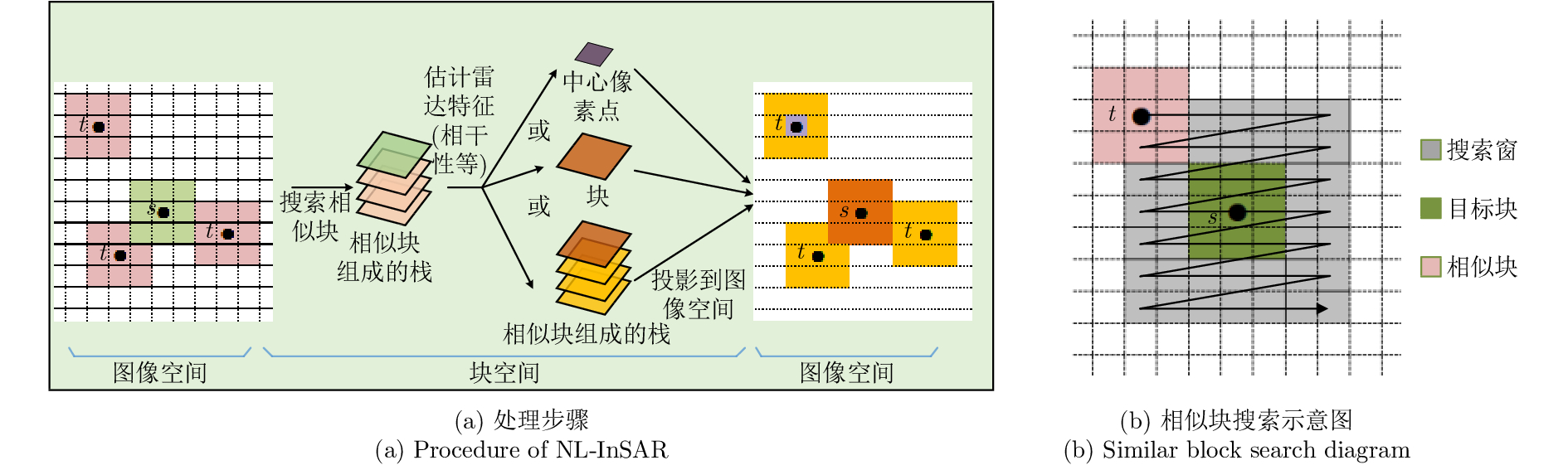
- Figure 1. Non-local filtering
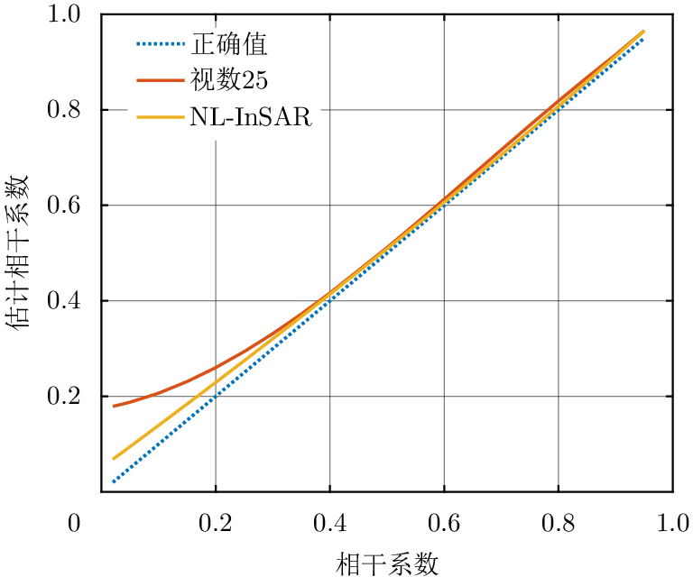
- Figure 2. Coherence estimates
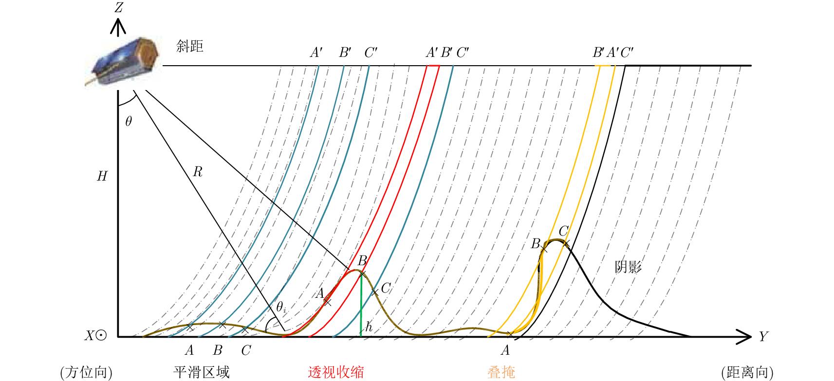
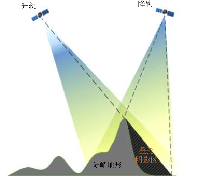
- Figure 3. Geometric distortion of SAR image
- Figure 4. Sketch map of ascending and descending
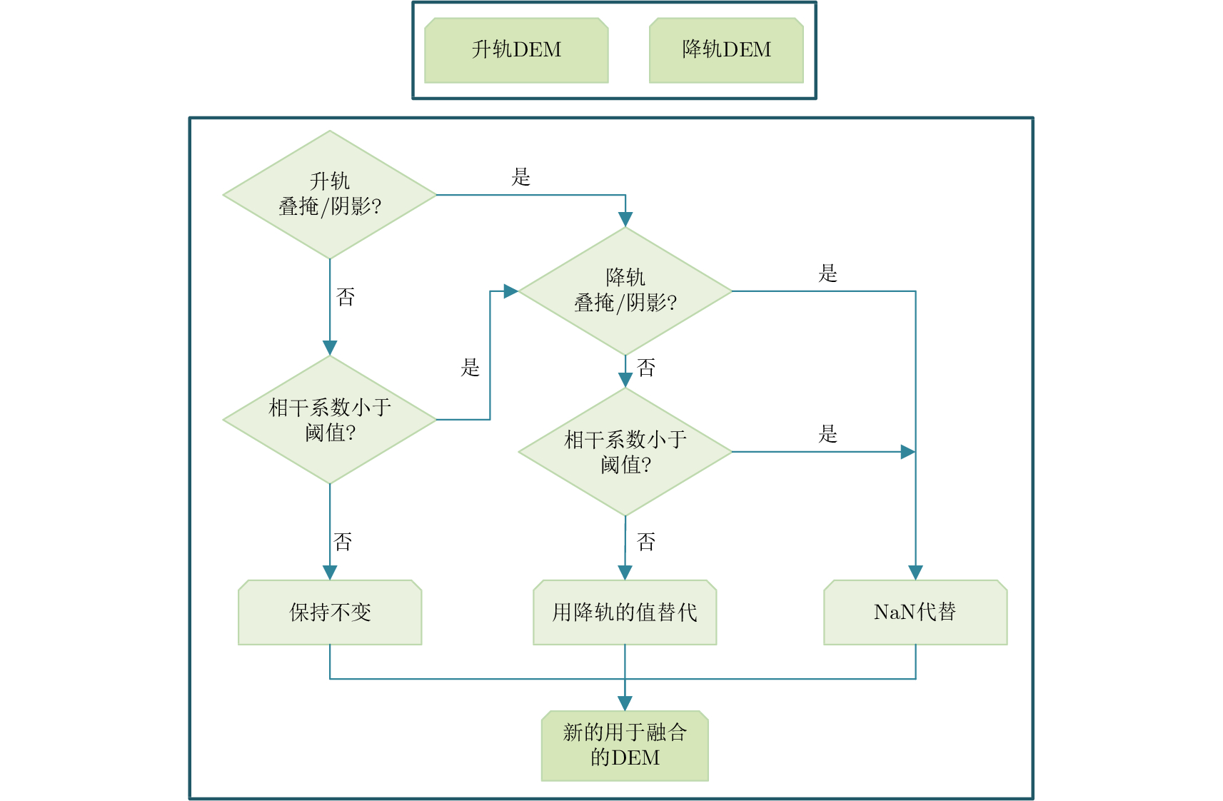
- Figure 5. Preprocessing of ascending and descending raw DEMs
- Figure 6. Flow chart of ascending and descending raw DEMs
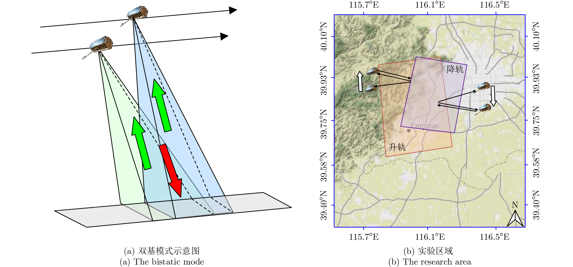
- Figure 7. the bistatic mode and the research area
- Figure 8. Contrast of different filters
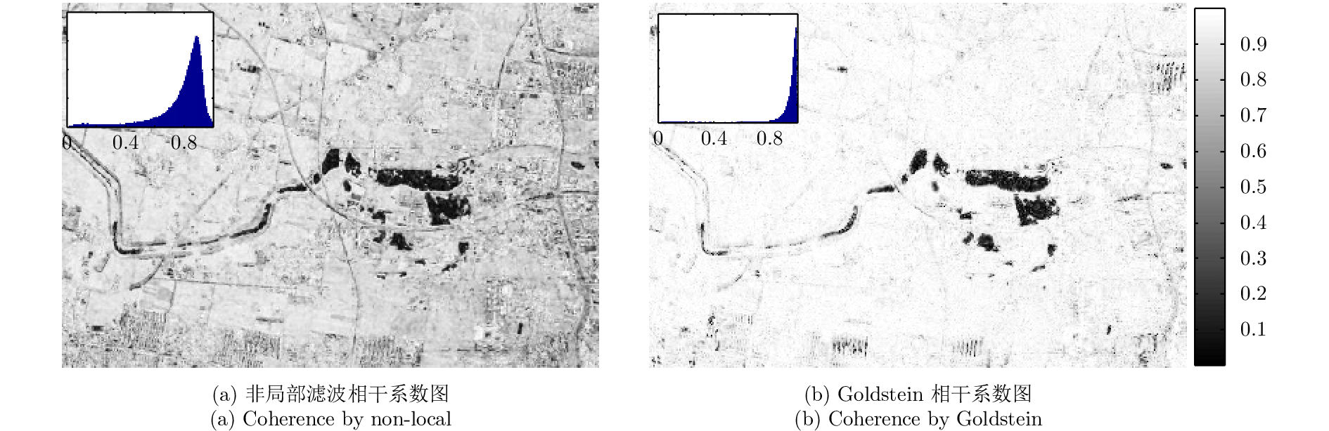
- Figure 9. Coherence by different filters
- Figure 10. DEM contrast by different methods
- Figure 11. Ascending and descending pass raw DEM (Overlaid red boundary is the common arear between two datasets)
- Figure 12. Fusion DEM of ascending and descending pass (City)
- Figure 13. Fusion DEM of ascending and descending pass (Hill)