
 Submit Manuscript
 Peer Review
 Editor Work
- Home
- Articles & Issues
-
Data
- Dataset of Radar Detecting Sea
- SAR Dataset
- SARGroundObjectsTypes
- SARMV3D
- AIRSAT Constellation SAR Land Cover Classification Dataset
- 3DRIED
- UWB-HA4D
- LLS-LFMCWR
- FAIR-CSAR
- MSAR
- SDD-SAR
- FUSAR
- SpaceborneSAR3Dimaging
- Sea-land Segmentation
- SAR Multi-domain Ship Detection Dataset
- SAR-Airport
- Hilly and mountainous farmland time-series SAR and ground quadrat dataset
- SAR images for interference detection and suppression
- HP-SAR Evaluation & Analytical Dataset
- GDHuiYan-ATRNet
- Multi-System Maritime Low Observable Target Dataset
- DatasetinthePaper
- DatasetintheCompetition
- Report
- Course
- About
- Publish
- Editorial Board
- Chinese

| Citation: | XIE Xin, DENG Yunkai, YANG Zhijun, et al. Topography-assisted UAV InSAR image registration method with image partition[J]. Journal of Radars, 2024, 13(1): 116–133. doi: 10.12000/JR23182

|
Topography-assisted UAV InSAR Image Registration Method with Image Partition
DOI: 10.12000/JR23182 CSTR: 32380.14.JR23182
More Information-
Abstract
Miniaturized and lightweight Unmanned Aerial Vehicles (UAV) provide a flexible platform for Synthetic Aperture Radar (SAR). The application of UAV Interferometric SAR (InSAR) is gradually increasing in interferometric measurement fields. UAVs are small and light, which are easily affected by airflow disturbances. Their trajectories are nonlinear and unparallel when adopting the multipass mode for interferometry. The nonlinear and unparallel trajectories result in geometric distortion between the interferometric image pairs. Under complex topography conditions, the interferometric image pairs of UAVs have large offsets that are obviously space-dependent, thereby resulting in substantial technical challenges during image registration. Conventional image registration methods based on polynomial fitting are no longer applicable. In this study, we proposed an image registration method based on image partition with topography assistance. First, an elevation threshold is generated based on the UAV trajectories, and the measurement area is partitioned using the assisted topography. Then, a polynomial fitting model is constructed for offsets within each partition with constraints applied at the partition boundaries for joint optimization. Finally, continuous global offset fitting surfaces are obtained, and precise image registration is achieved by resampling the slave image. The effectiveness of the proposed method is preliminarily validated using real measurement data obtained from UAV InSAR in the P-band. -

-
References
[1] MOREIRA A, PRATS-IRAOLA P, YOUNIS M, et al. A tutorial on synthetic aperture radar[J]. IEEE Geoscience and Remote Sensing Magazine, 2013, 1(1): 6–43. doi: 10.1109/MGRS.2013.2248301[2] 韦顺军, 唐欣欣, 张晓玲. 基于DFT模型的大场景InSAR图像配准[J]. 遥感学报, 2019, 23(5): 859–870. doi: 10.11834/jrs.20197459WEI Shunjun, TANG Xinxin, and ZHANG Xiaoling. Image registration algorithm for InSAR large scenes via DFT model[J]. Journal of Remote Sensing, 2019, 23(5): 859–870. doi: 10.11834/jrs.20197459[3] LIN Xue, FANGI D S, and LI Fangfang. Acqusition of high-precision digital terrain model using P-band airborne repeat-pass SAR interferometry[C]. 2016 CIE International Conference on Radar (RADAR), Guangzhou, China, 2016: 1–4.[4] ZENG Tao, LIU Minkun, WANG Yan, et al. Tomographic SAR imaging with large elevation aperture: A P-band small UAV demonstration[J]. Science China Information Sciences, 2022, 65(3): 132303. doi: 10.1007/s11432-021-3391-2[5] SANSOSTI E, BERARDINO P, MANUNTA M, et al. Geometrical SAR image registration[J]. IEEE Transactions on Geoscience and Remote Sensing, 2006, 44(10): 2861–2870. doi: 10.1109/TGRS.2006.875787[6] ZOU Weibao and CHEN Libin. Determination of optimum tie point interval for SAR image coregistration by decomposing autocorrelation coefficient[J]. IEEE Transactions on Geoscience and Remote Sensing, 2019, 57(7): 5067–5084. doi: 10.1109/TGRS.2019.2896383[7] MA Zhangfeng, JIANG Mi, ZHAO Yi, et al. Minimum spanning tree co-registration approach for time-series sentinel-1 TOPS data[J]. IEEE Journal of Selected Topics in Applied Earth Observations and Remote Sensing, 2019, 12(8): 3004–3013. doi: 10.1109/JSTARS.2019.2920717[8] YAGUE-MARTINEZ N, EINEDER M, CONG Xiaoying, et al. Ground displacement measurement by TerraSAR-X image correlation: The 2011 Tohoku-Oki earthquake[J]. IEEE Geoscience and Remote Sensing Letters, 2012, 9(4): 539–543. doi: 10.1109/LGRS.2012.2196020[9] SCHEIBER R and MOREIRA A. Coregistration of interferometric SAR images using spectral diversity[J]. IEEE Transactions on Geoscience and Remote Sensing, 2000, 38(5): 2179–2191. doi: 10.1109/36.868876[10] ZOU Weibao, LI Yan, LI Zhilin, et al. Improvement of the accuracy of InSAR image co-registration based on tie points— a review[J]. Sensors, 2009, 9(2): 1259–1281. doi: 10.3390/s90201259[11] ZITOVÁ B and FLUSSER J. Image registration methods: A survey[J]. Image and Vision Computing, 2003, 21(11): 977–1000. doi: 10.1016/S0262-8856(03)00137-9[12] HE Ke, CHEN Yongguang, JIA Xin, et al. A method based on interpolation mapping function for InSAR image registration[C]. 2016 IEEE International Conference on Electronic Information and Communication Technology (ICEICT), Harbin, China, 2016: 351–355.[13] DELLINGER F, DELON J, GOUSSEAU Y, et al. SAR-SIFT: A SIFT-Like algorithm for SAR images[J]. IEEE Transactions on Geoscience and Remote Sensing, 2015, 53(1): 453–466. doi: 10.1109/TGRS.2014.2323552[14] PAUL S and PATI U C. SAR image registration using an improved SAR-SIFT algorithm and Delaunay- Triangulation-based local matching[J]. IEEE Journal of Selected Topics in Applied Earth Observations and Remote Sensing, 2019, 12(8): 2958–2966. doi: 10.1109/JSTARS.2019.2918211[15] WANG Linhui, XIANG Yuming, YOU Hongjia, et al. A robust multiscale edge detection method for accurate SAR image registration[J]. IEEE Geoscience and Remote Sensing Letters, 2023, 20: 4006305. doi: 10.1109/LGRS.2023.3279141[16] LI Xin, WANG Taoyang, CUI Hao, et al. SARPointNet: An automated feature learning framework for spaceborne SAR image registration[J]. IEEE Journal of Selected Topics in Applied Earth Observations and Remote Sensing, 2022, 15: 6371–6381. doi: 10.1109/JSTARS.2022.3196383[17] YANG Zhuoqian, DAN Tingting, and YANG Yang. Multi-Temporal remote sensing image registration using deep convolutional features[J]. IEEE Access, 2018, 6: 38544–38555. doi: 10.1109/ACCESS.2018.2853100[18] XIANG Yuming, PENG Lingxiao, WANG Feng, et al. Fast registration of multiview slant-range SAR images[J]. IEEE Geoscience and Remote Sensing Letters, 2022, 19: 4007505. doi: 10.1109/LGRS.2020.3045099[19] YE Yuanxin, TANG Tengfeng, ZHU Bai, et al. A multiscale framework with unsupervised learning for remote sensing image registration[J]. IEEE Transactions on Geoscience and Remote Sensing, 2022, 60: 5622215. doi: 10.1109/TGRS.2022.3167644[20] BOVEIRI H R, KHAYAMI R, JAVIDAN R, et al. Medical image registration using Deep Neural Networks: A comprehensive review[J]. Computers & Electrical Engineering, 2020, 87: 106767. doi: 10.1016/j.compeleceng.2020.106767[21] FREY O, WERNER C L, and COSCIONE R. Car-borne and UAV-borne mobile mapping of surface displacements with a compact repeat-pass interferometric SAR system at L-band[C]. IGARSS 2019-2019 IEEE International Geoscience and Remote Sensing Symposium, Yokohama, Japan, 2019: 274–277.[22] WANG Yan, DING Zegang, LI Linghao, et al. First demonstration of single-pass distributed SAR tomographic imaging with a P-band UAV SAR prototype[J]. IEEE Transactions on Geoscience and Remote Sensing, 2022, 60: 1–18. doi: 10.1109/TGRS.2022.3221859[23] WANG Zhen, DING Zegang, SUN Tao, et al. UAV-based P-band SAR tomography with long baseline: A multimaster approach[J]. IEEE Transactions on Geoscience and Remote Sensing, 2023, 61: 1–21. doi: 10.1109/TGRS.2023.3272039[24] 邓云开, 袁泉, 胡程, 等. 一种多部地基SAR联合观测时的图形配准方法[J]. 信号处理, 2018, 34(11): 1269–1276. doi: 10.16798/j.issn.1003-0530.2018.11.001DENG Yunkai, YUAN Quan, HU CHENG, et al. An image registration method applied for joint measurements of multiple GB-SAR[J]. Journal of Signal Processing, 2018, 34(11): 1269–1276. doi: 10.16798/j.issn.1003-0530.2018.11.001[25] NITTI D O, HANSSEN R F, REFICE A, et al. Impact of DEM-assisted coregistration on high-resolution SAR interferometry[J]. IEEE Transactions on Geoscience and Remote Sensing, 2011, 49(3): 1127–1143. doi: 10.1109/TGRS.2010.2074204[26] 黄晓涛, 陈乐平, 范崇祎, 等. 低频叶簇穿透雷达成像技术[J]. 电波科学学报, 2020, 35(4): 469–485. doi: 10.13443/j.cjors.2020041302HUANG Xiaotao, CHEN Leping, FAN Chongyi, et al. Low frequency foliage penetration radar imaging technology[J]. Chinese Journal of Radio Science, 2020, 35(4): 469–485. doi: 10.13443/j.cjors.2020041302[27] HAN Congrong, TIAN Weiming, and MEI Hongyan. MIMO radar fast imaging algorithm based on sub-image combination[C]. 2019 6th Asia-Pacific Conference on Synthetic Aperture Radar (APSAR), Xiamen, China, 2019: 1–6.[28] LIN Jiahe, LV Xiaolei, and LI Rui. Automatic registered back-projection approach based on object orientation for airborne repeat-track interferometric SAR[J]. IET Radar, Sonar & Navigation, 2018, 12(9): 1066–1076. doi: 10.1049/iet-rsn.2018.5053[29] 田卫明, 刘富强, 谢鑫, 等. 基于GPU粗细粒度和混合精度的SAR后向投影算法的并行加速研究[J/OL]. 信号处理, 1–12. http://kns.cnki.net/kcms/detail/11.2406.tn.20230509.0955.002.html, 2023.TIAN Weiming, LIU Fuqiang, XIE Xin, et al. Research on parallel acceleration processing technology of SAR back projection algorithm based on two granularities and mixing precision of GPU[J/OL]. Journal of Signal Processing, 1–12. http://kns.cnki.net/kcms/detail/11.2406.tn.20230509.0955.002.html, 2023.[30] 冯丽源, 邓云开, 聂祥飞, 等. 一种基于Non-Local Means的地基差分干涉雷达相位滤波改进方法[J]. 信号处理, 2022, 38(1): 100–108. doi: 10.16798/j.issn.1003-0530.2022.01.012FENG Liyuan, DENG Yunkai, NIE Xiangfei, et al. An improved phase filtering method for Ground-based differential interferometer radar based on Non-Local means[J]. Journal of Signal Processing, 2022, 38(1): 100–108. doi: 10.16798/j.issn.1003-0530.2022.01.012[31] FANG Dongsheng, LV Xiaolei, YUN Ye, et al. An InSAR fine registration algorithm using uniform tie points based on voronoi diagram[J]. IEEE Geoscience and Remote Sensing Letters, 2017, 14(8): 1403–1407. doi: 10.1109/LGRS.2017.2715189 -
Proportional views


- Publishing Ethics
- Journal Insights
- Abstracting & Indexing
- Peer Review Policies
- Guide for Authors
- Conference
- ISSN 2095-283X (Print)ISSN 2097-339X (Online)
- CN 10-1030/TN
- CODEN LXEUAO
About Journal
- Sponsor: China Radio Detection and Ranging Industry Association (CRIA)
- Phone: 010-58887062
- Email:radars@aircas.ac.cn
- Publisher: Leida Xuebao Bianjibu (Editorial office of the Journal of Radars)
Contacts Us

京ICP备20021838号-14
Supported by: Beijing Renhe Information Technology Co. Ltd

Export File
Citation
Format
Content
 DownLoad:


- Figure 1. Conventional linear aperture SAR imaging geometry
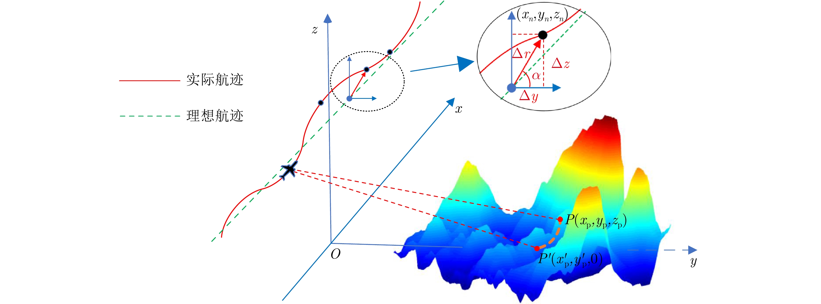
- Figure 2. UAV SAR imaging geometry
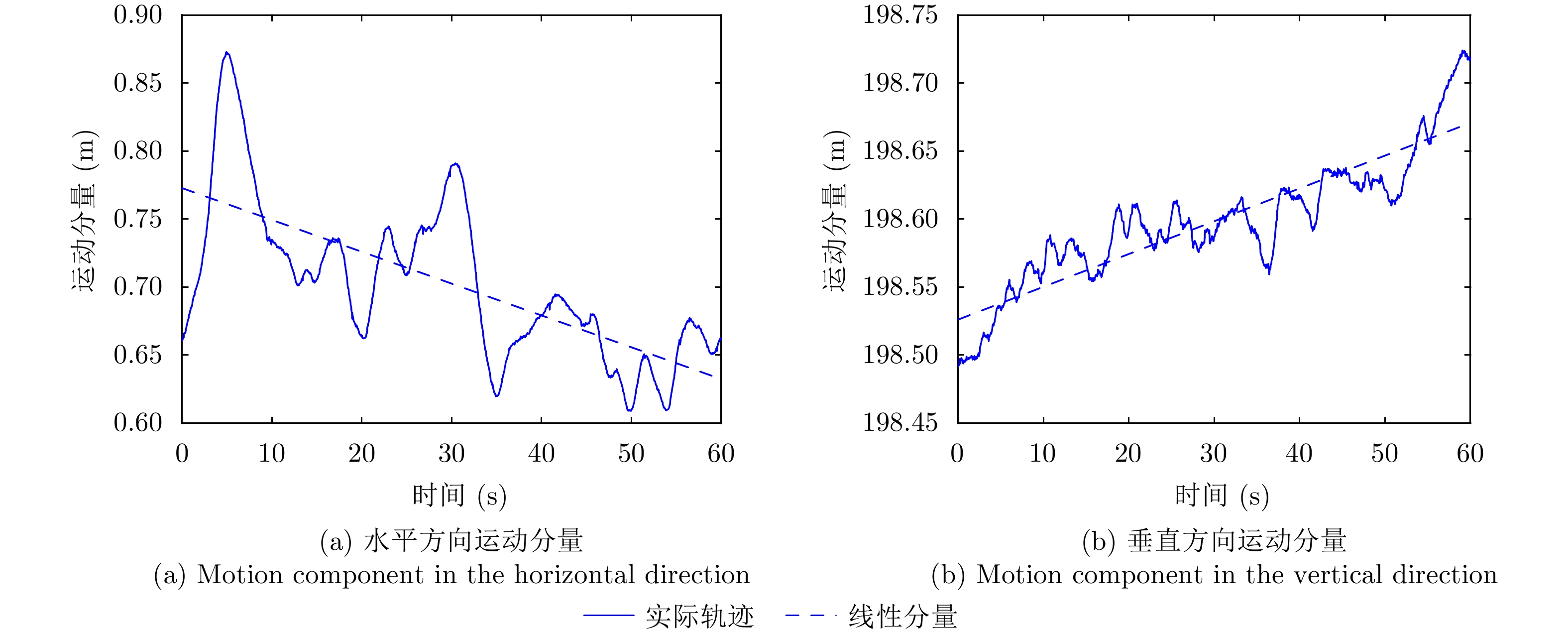
- Figure 3. Motion component of the actual trajectory
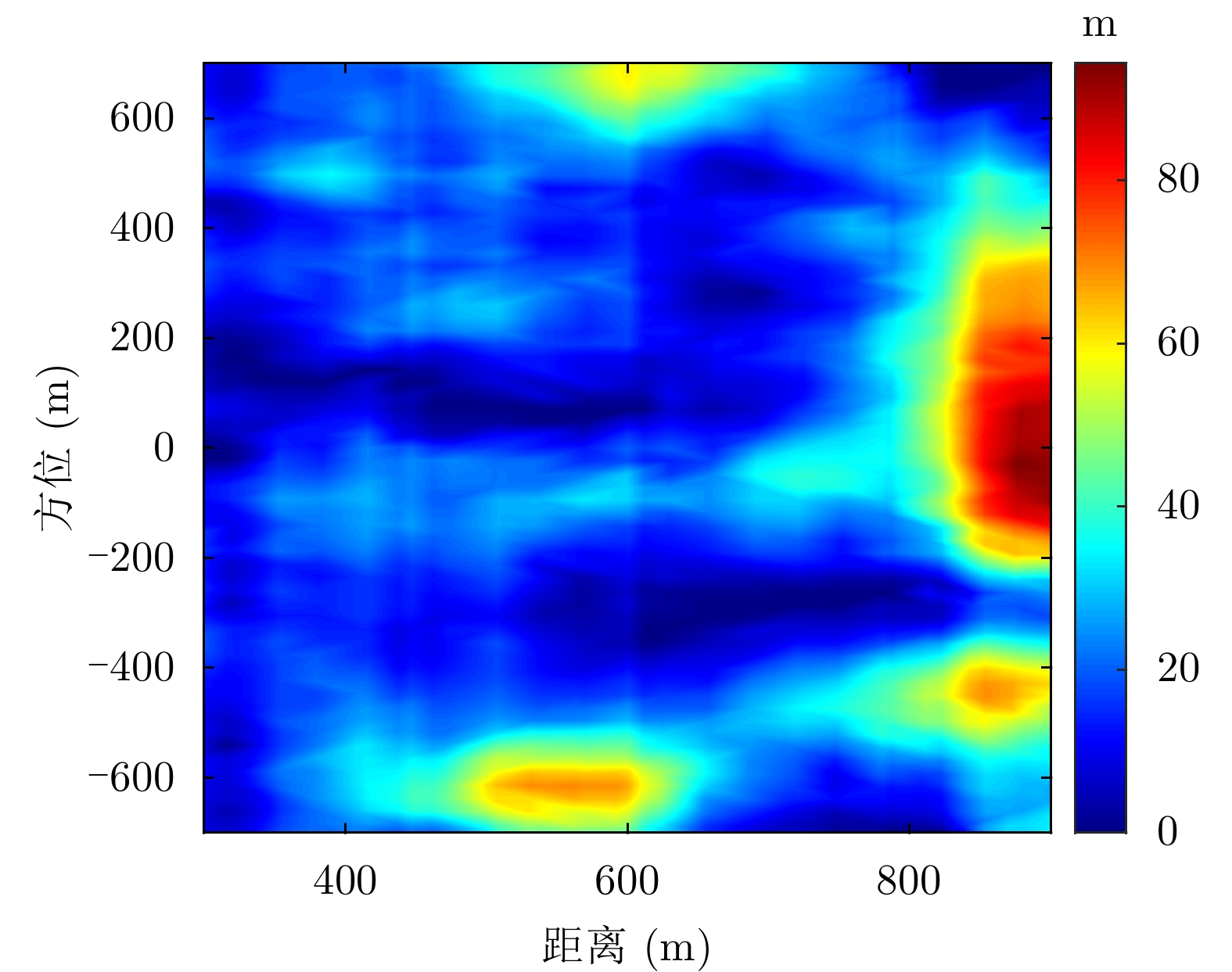
- Figure 4. Simulation topography elevation
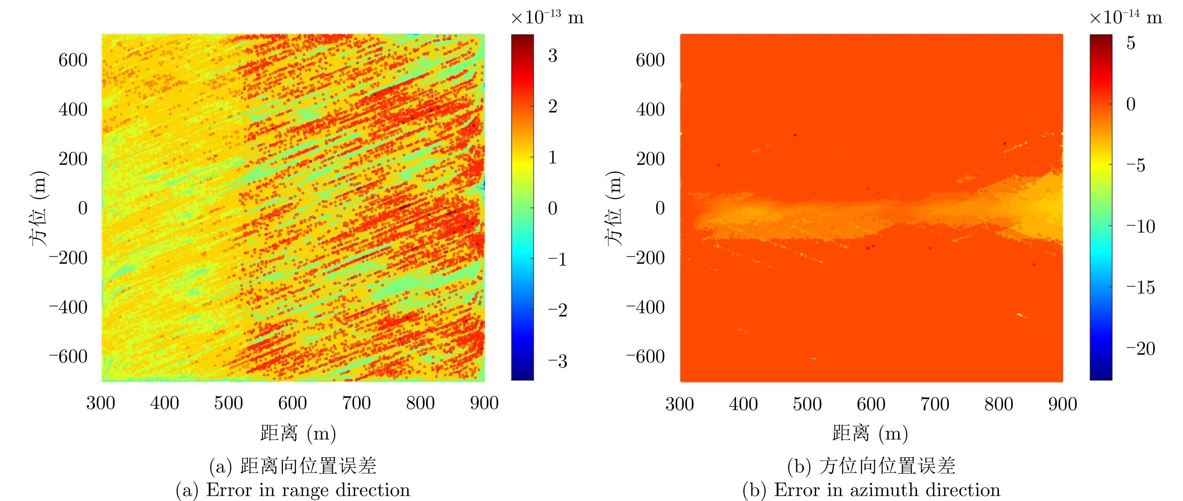
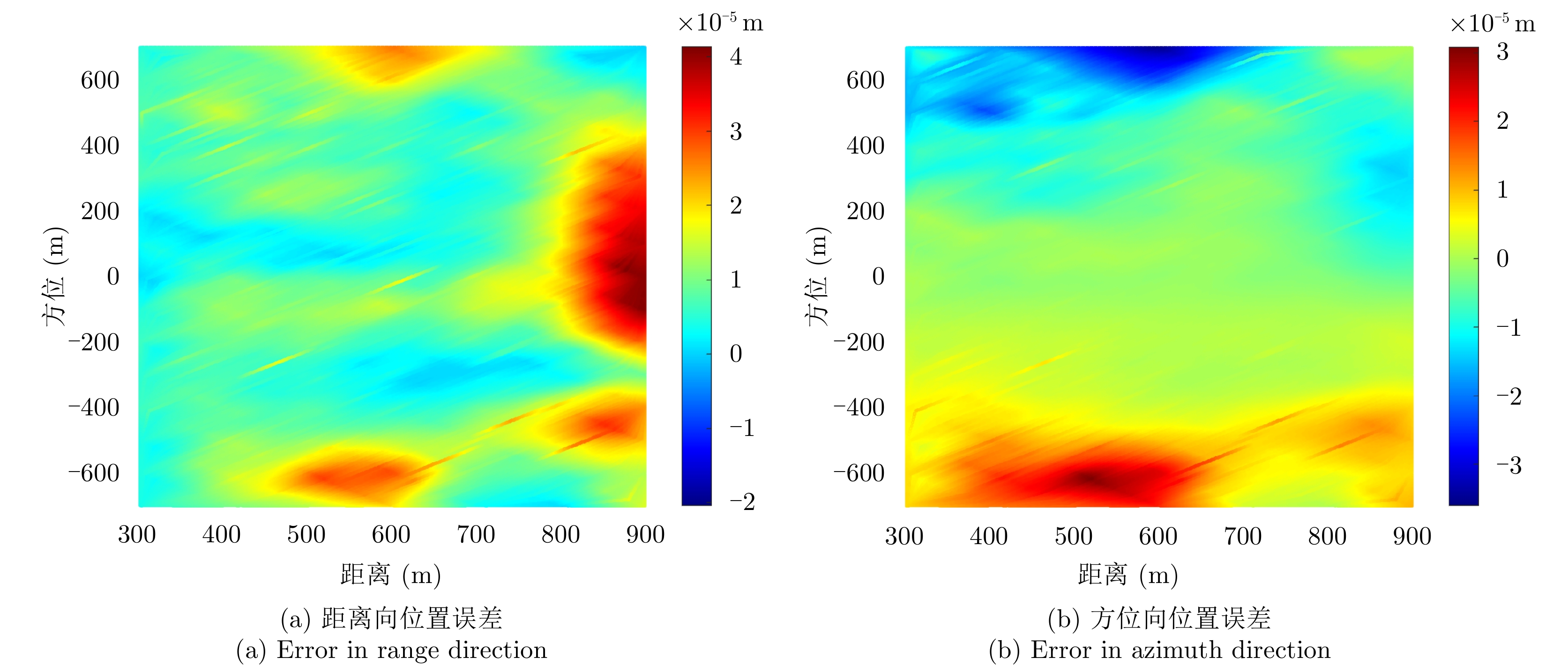
- Figure 5. Error between the iteration solution and the real projection point
- Figure 6. Error between the iterative solution and initial solution
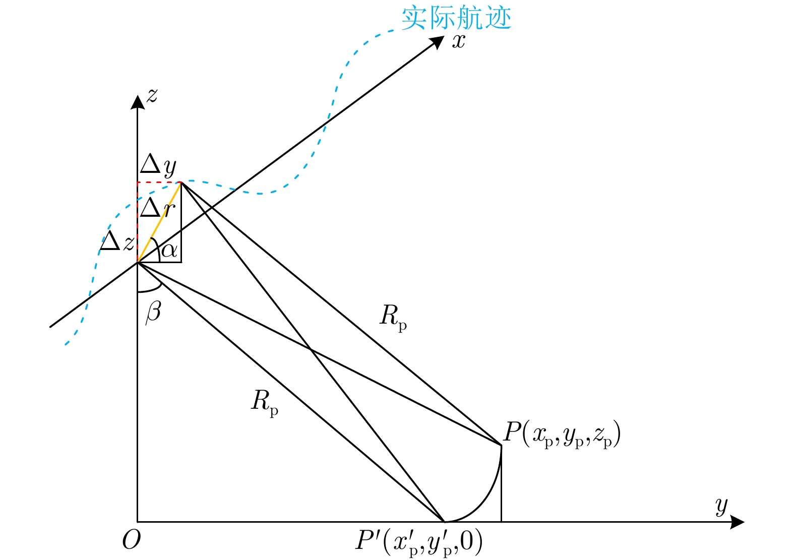
- Figure 7. Projection geometry with motion error
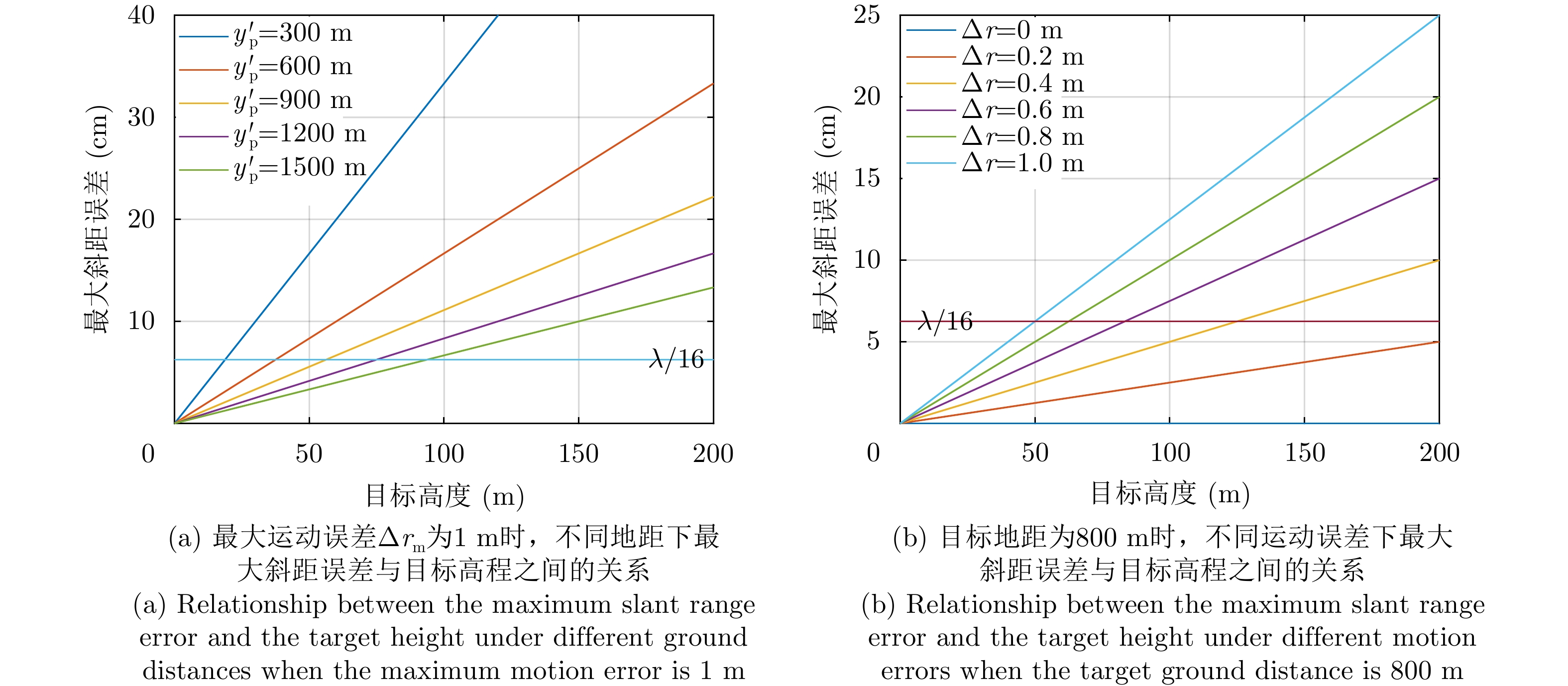
- Figure 8. Relationship between the maximum slant range error and the target height with different the maximum motion error and the target ground distance
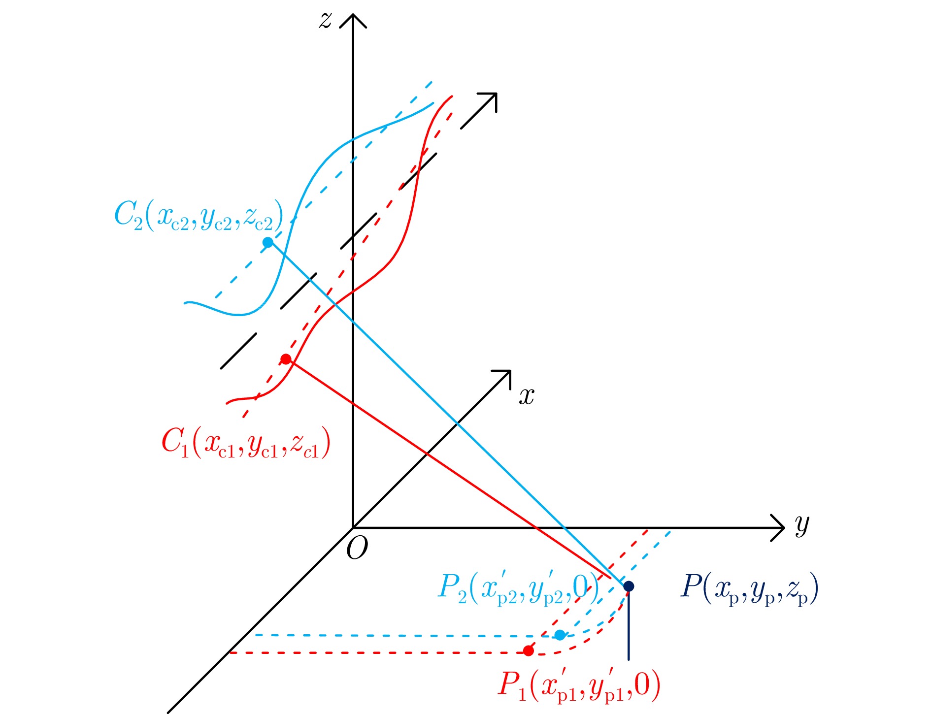
- Figure 9. UAV InSAR interferometric projection geometry
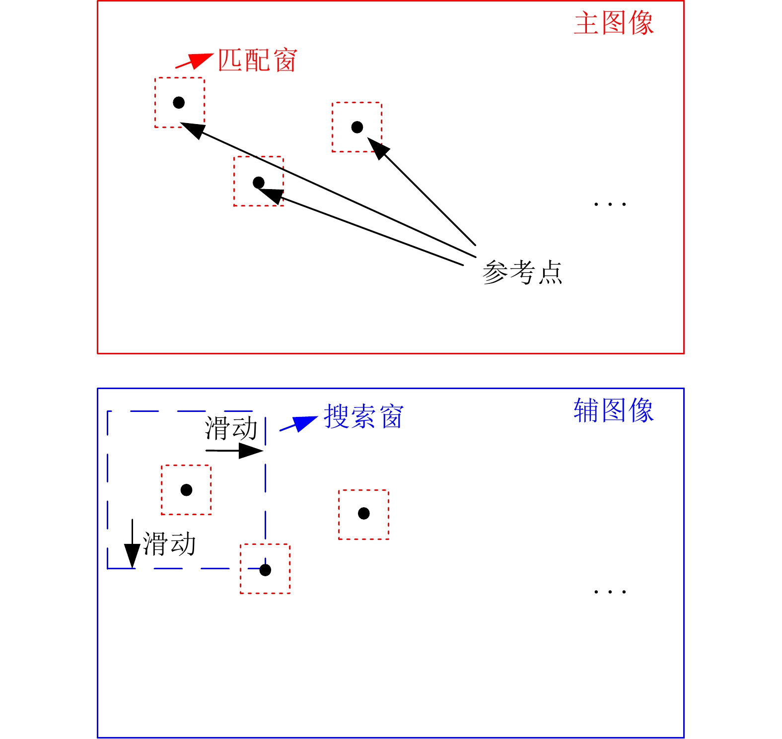
- Figure 10. Schematic diagram of match window and search window
- Figure 11. Flowchart of topography-assisted UAV InSAR registration method with image partition
- Figure 12. P-band UAV SAR system
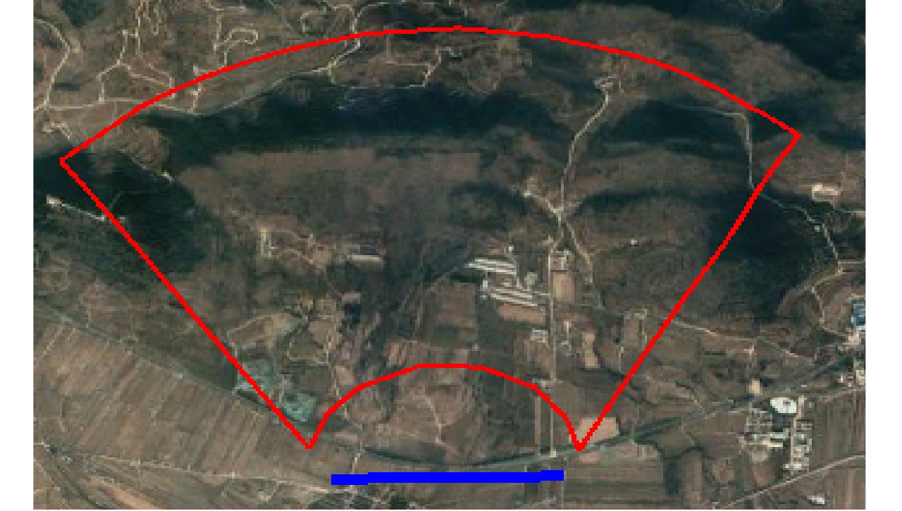
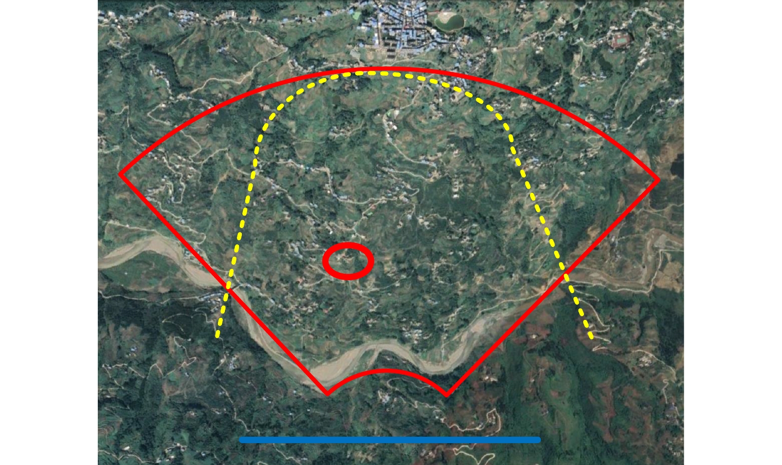
- Figure 13. Jinhai Lake airport experiment scene
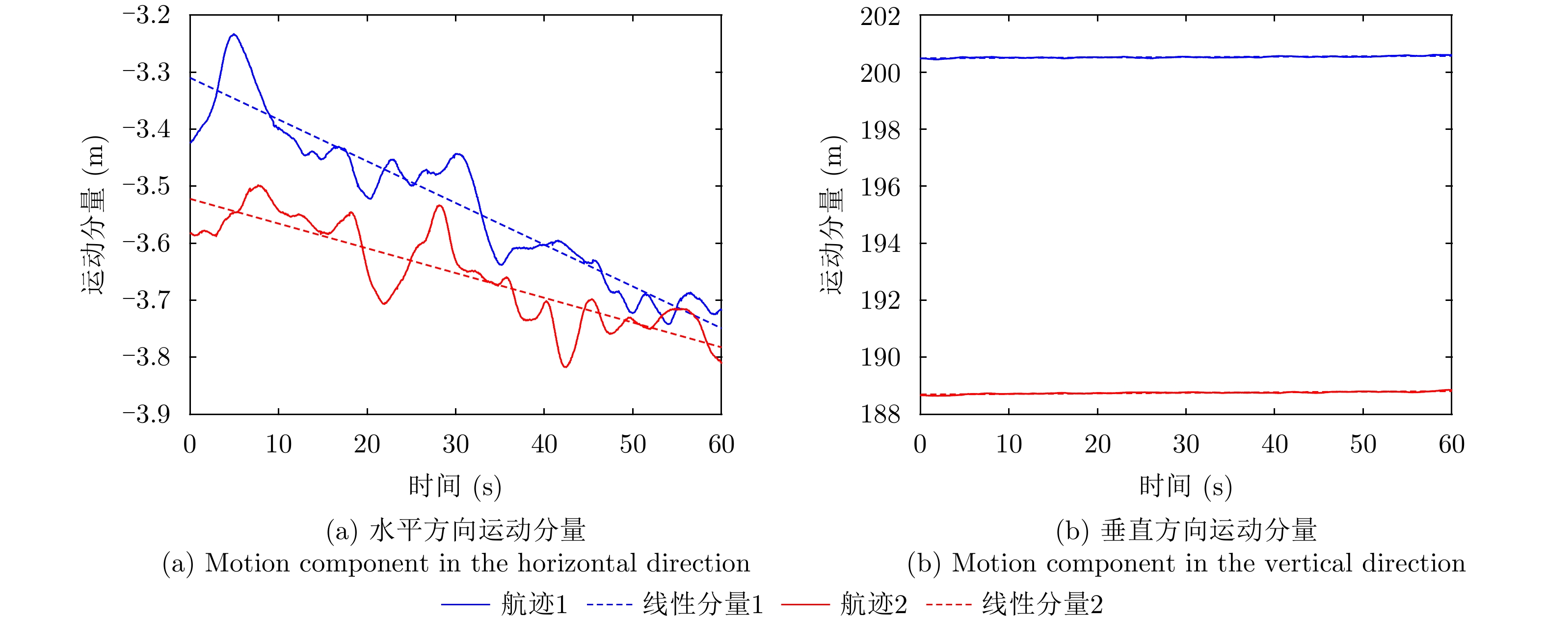
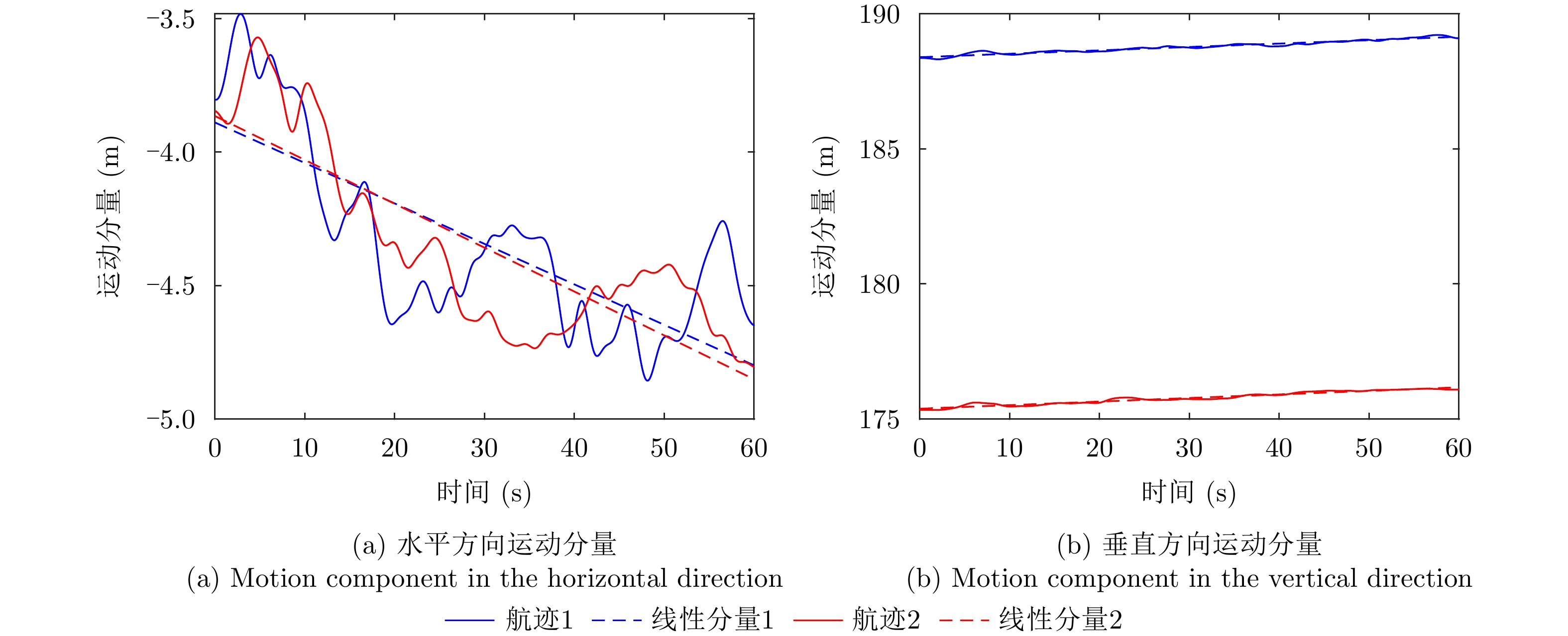
- Figure 14. Motion components of two trajectories in Jinhai Lake
- Figure 15. DEM results from SRTM of Jinhai Lake
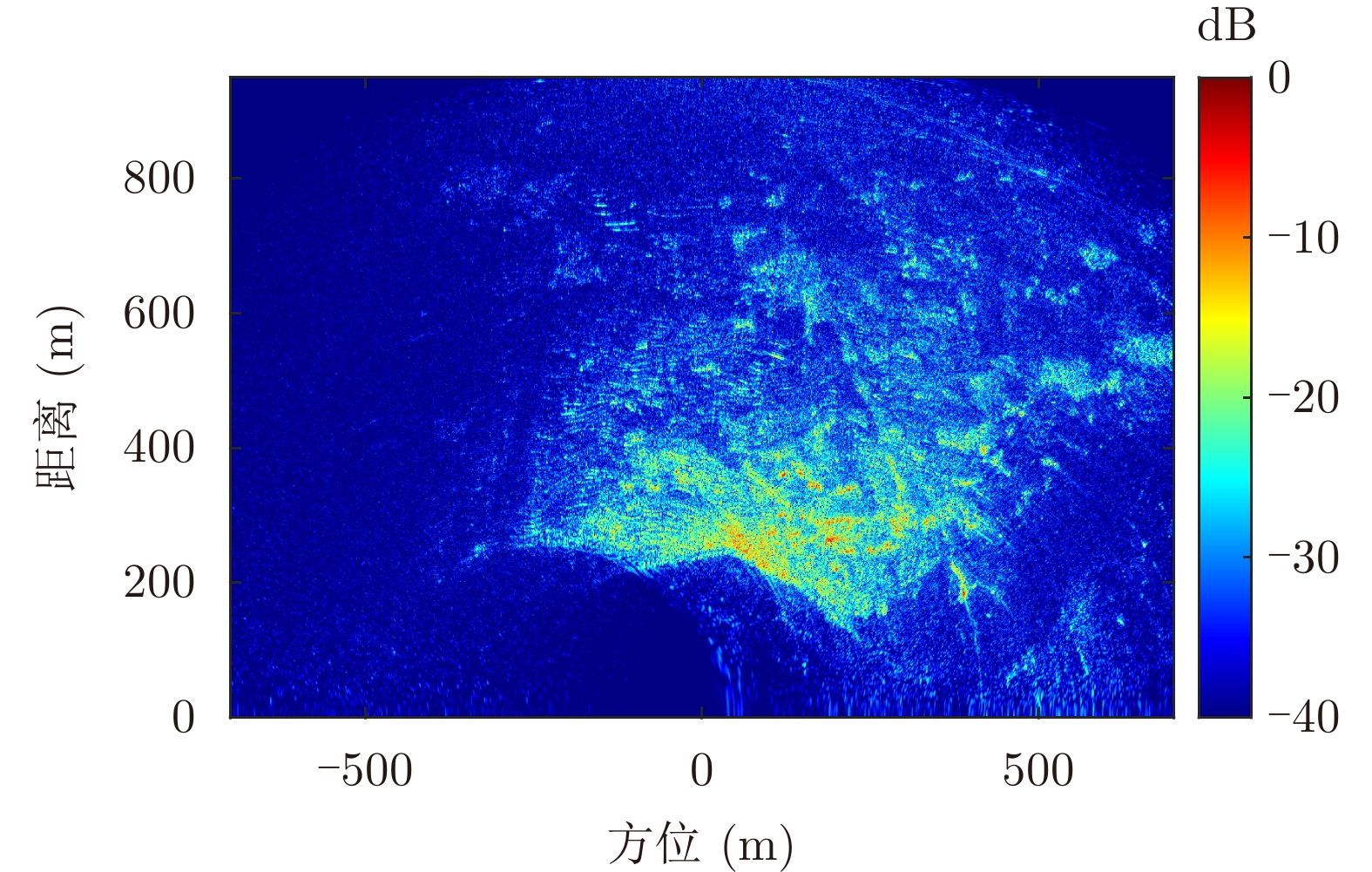
- Figure 16. The imaging result of Jinhai Lake
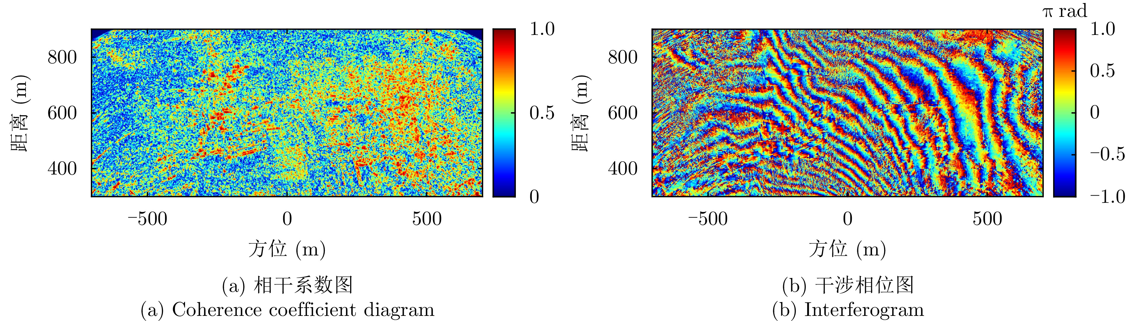
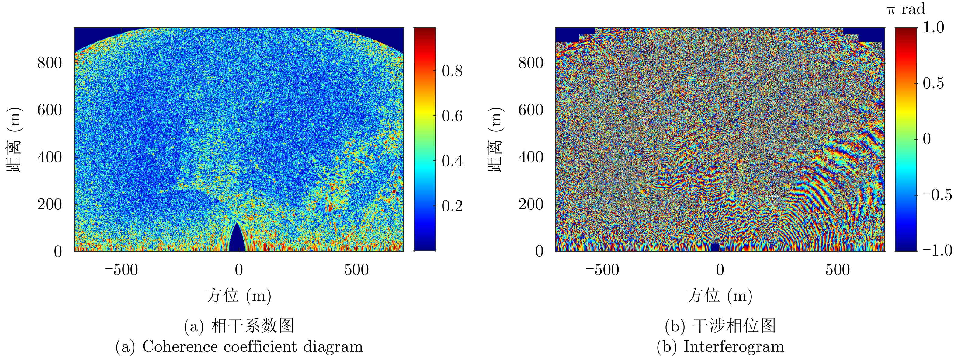
- Figure 17. Coherence coefficient diagram and interferogram with 12 m baseline before registration of Jinhai Lake
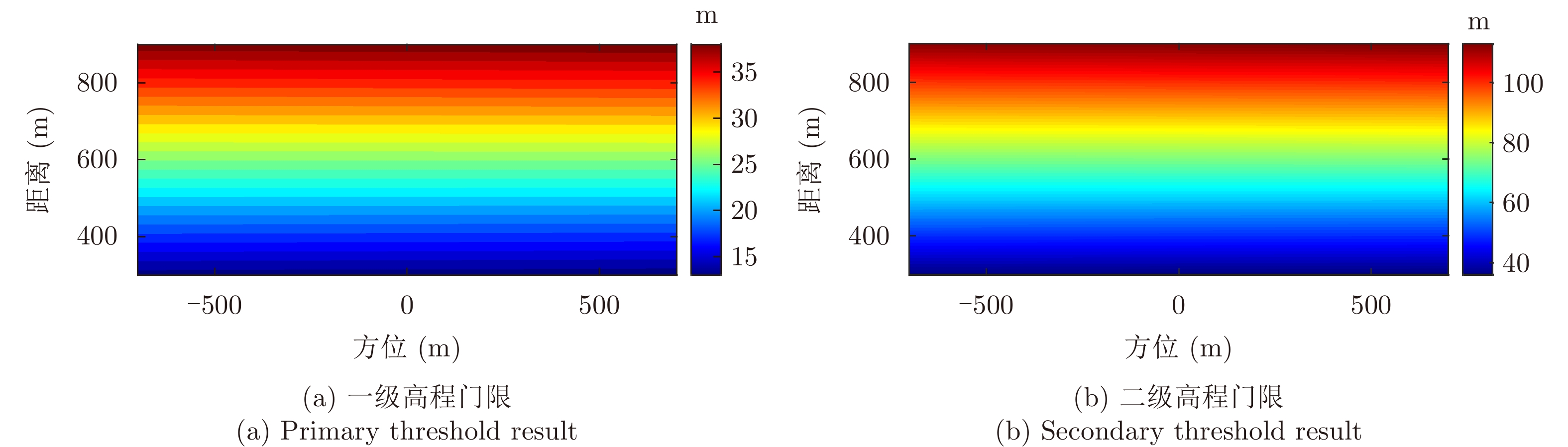
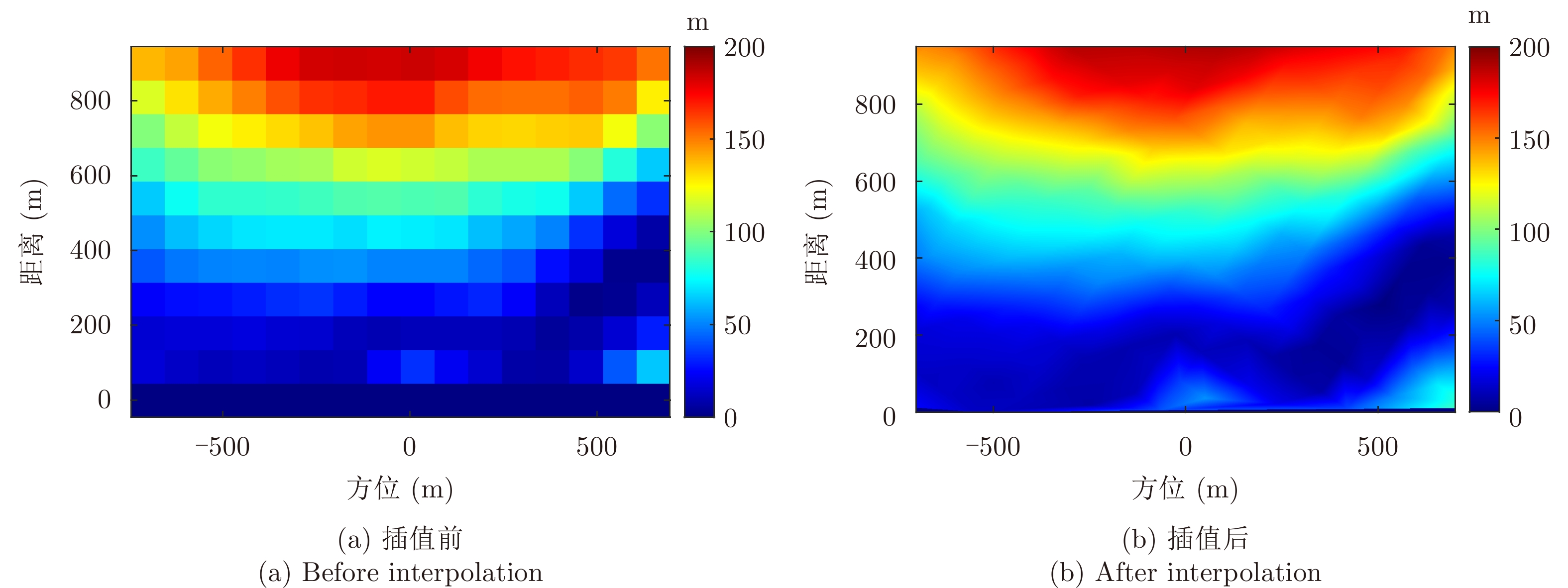
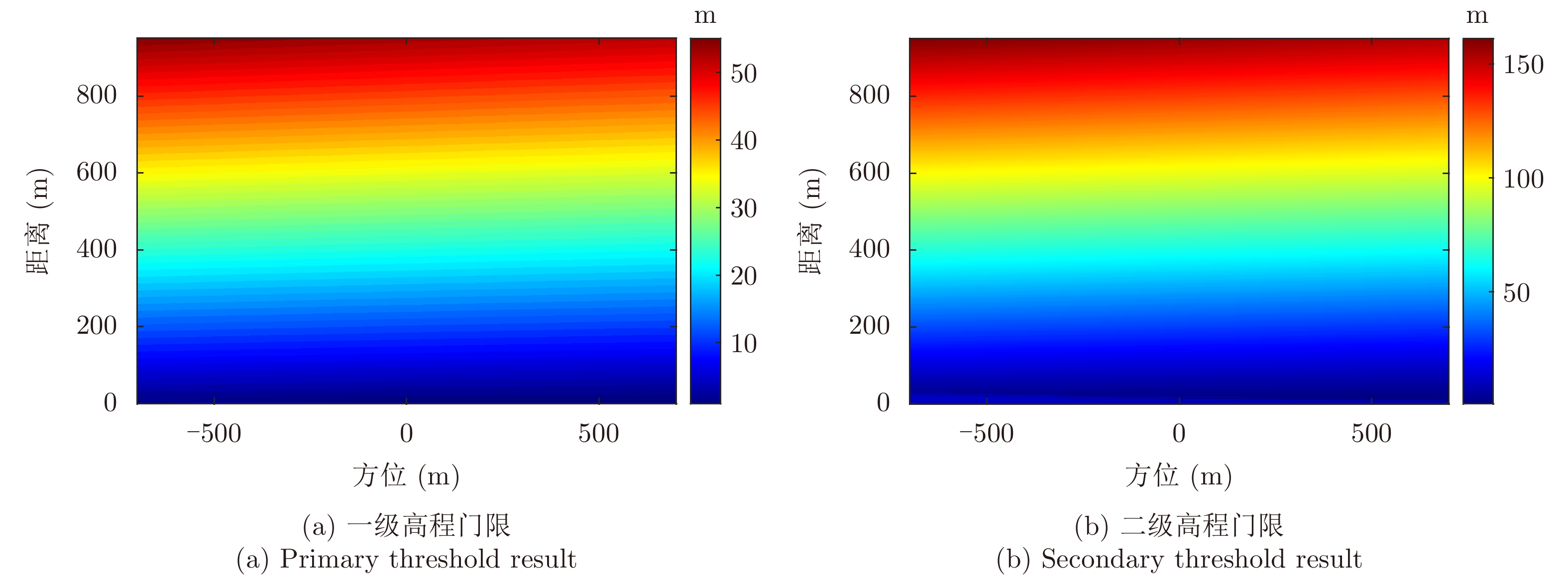
- Figure 18. Threshold results of Jinhai Lake
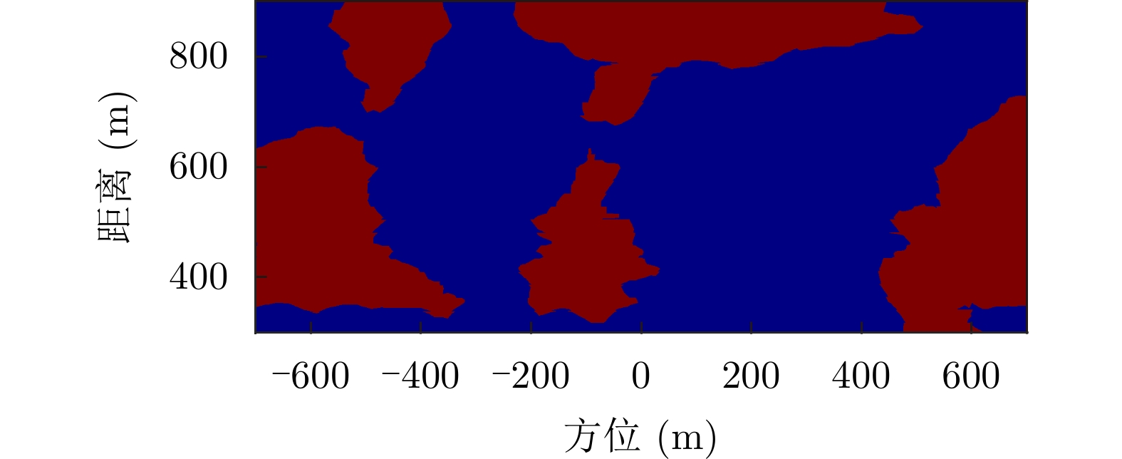
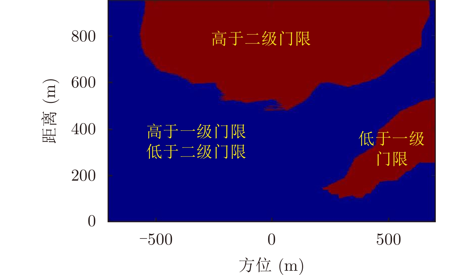
- Figure 19. The segmentation result of Jinhai Lake
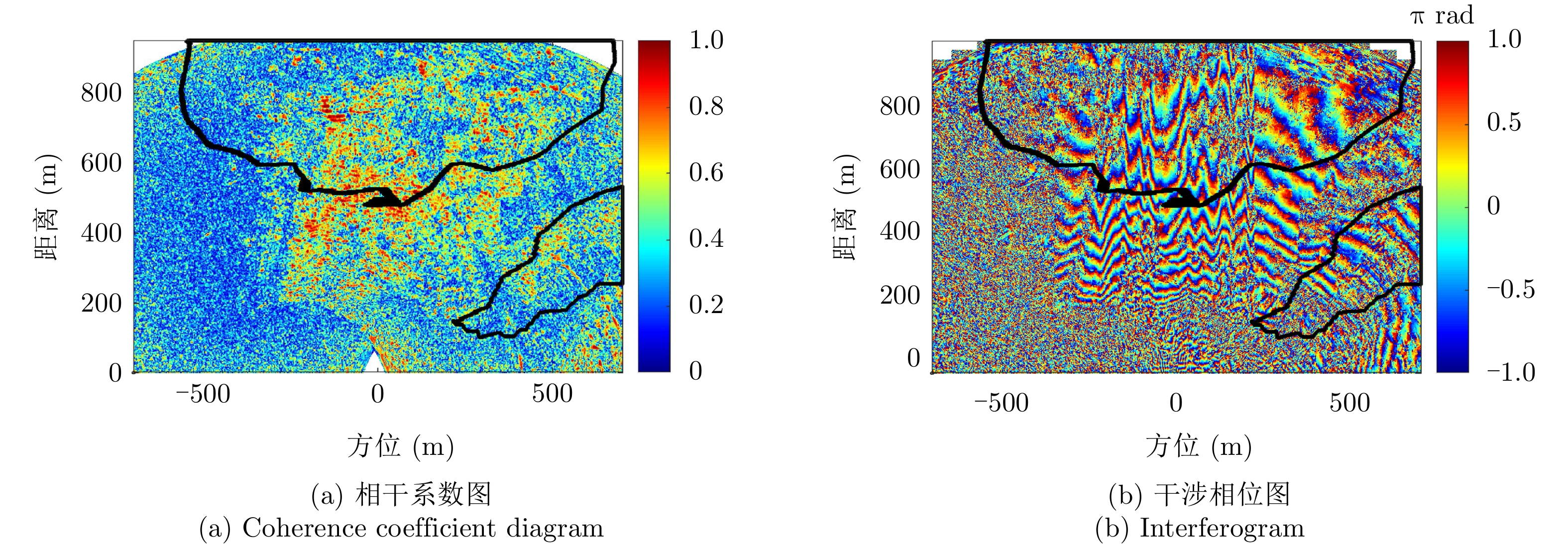
- Figure 20. Comparison between the segmentation results of Jinhai Lake
- Figure 21. Fine registration results of the proposed method of Jinhai Lake
- Figure 22. Coherence coefficient diagrams and interferograms after registration of common InSAR methods of Jinhai Lake
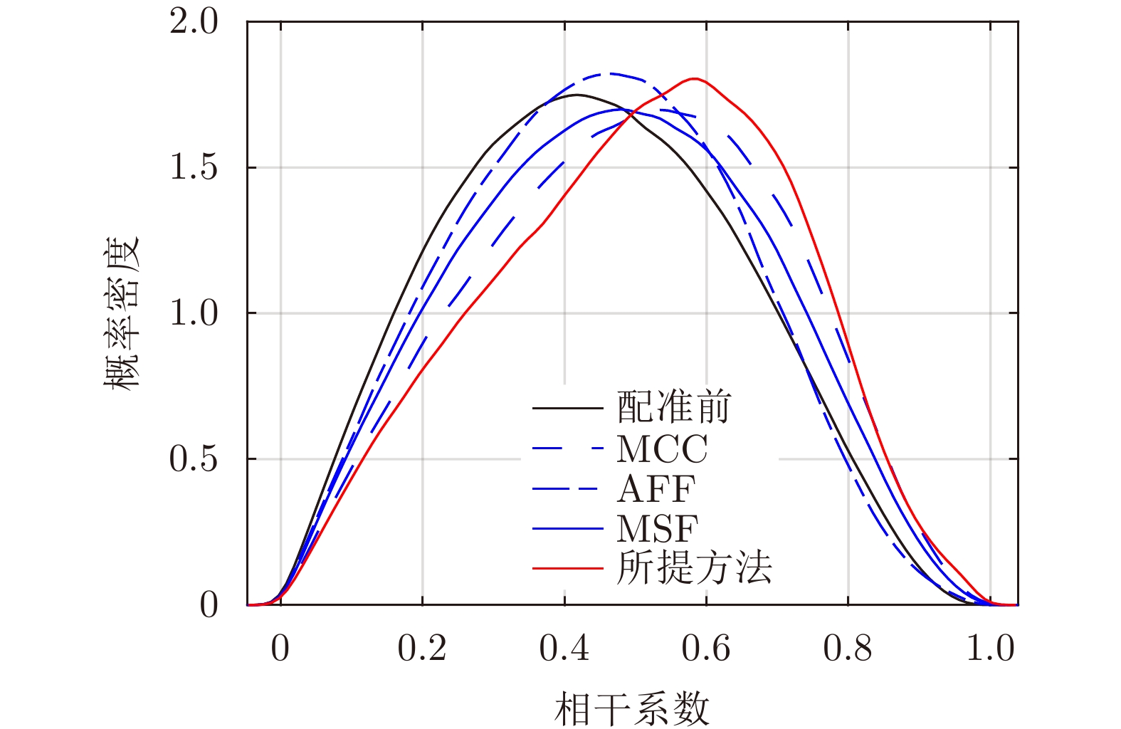
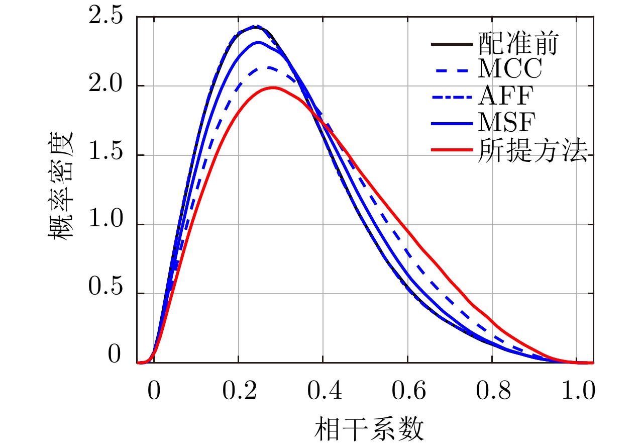
- Figure 23. Coherence coefficient distribution with different methods of Jinhai Lake
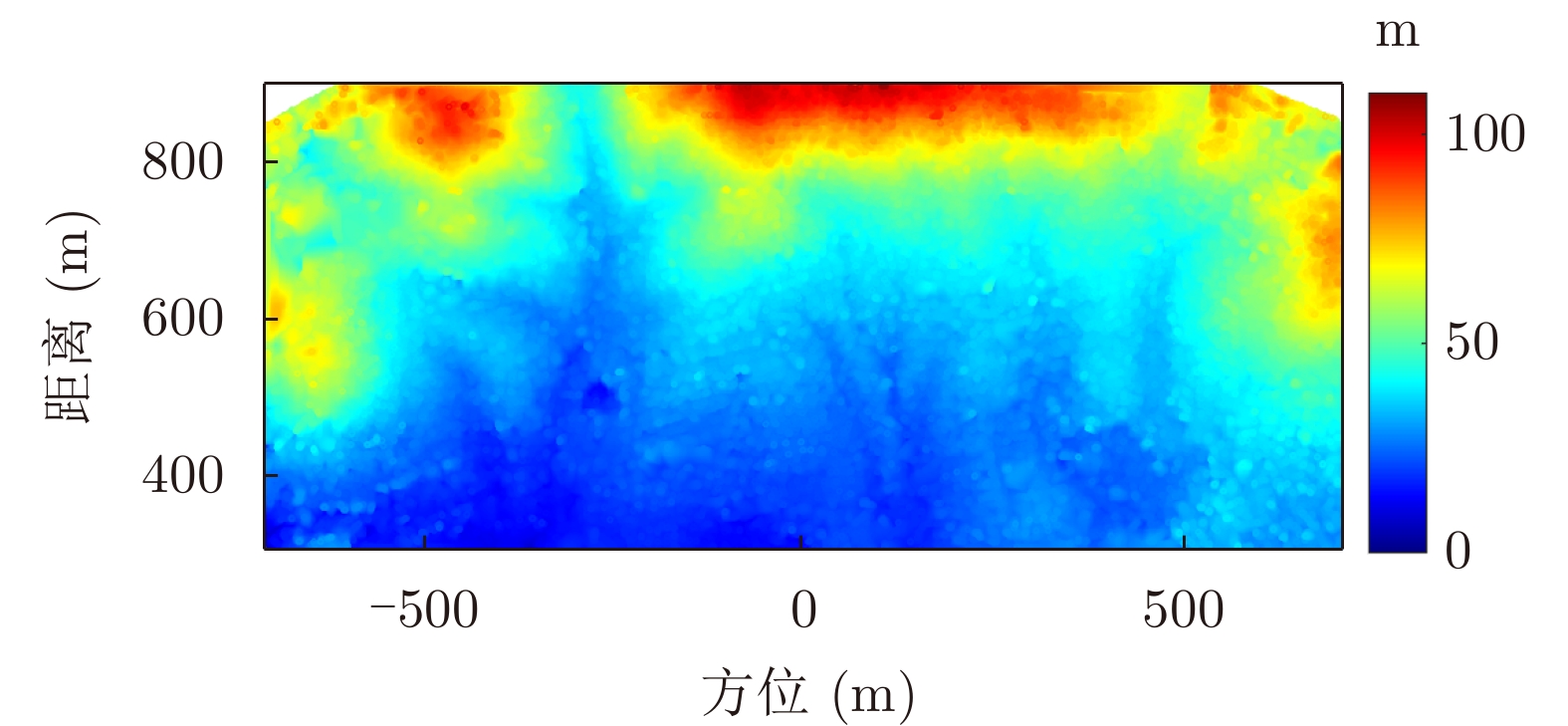
- Figure 24. Topography result of the proposed method
- Figure 25. Laolin Gou experiment scene
- Figure 26. Motion components of two trajectories in Laolin Gou
- Figure 27. DEM results from SRTM of Laolin Gou
- Figure 28. The imaging result of Laolin Gou
- Figure 29. Coherence coefficient diagram and interferogram with 13 m baseline before registration of Laolin Gou
- Figure 30. Threshold results of Laolin Gou
- Figure 31. Segmentation result of Laolin Gou
- Figure 32. Fine registration results of the proposed method of Laolin Gou
- Figure 33. Coherence coefficient diagrams and interferograms after registration of common InSAR methods of Laolin Gou
- Figure 34. Coherence coefficient distribution with different methods of Laolin Gou