
 Submit Manuscript
 Peer Review
 Editor Work
- Home
- Articles & Issues
-
Data
- Dataset of Radar Detecting Sea
- SAR Dataset
- SARGroundObjectsTypes
- SARMV3D
- AIRSAT Constellation SAR Land Cover Classification Dataset
- 3DRIED
- UWB-HA4D
- LLS-LFMCWR
- FAIR-CSAR
- MSAR
- SDD-SAR
- FUSAR
- SpaceborneSAR3Dimaging
- Sea-land Segmentation
- SAR Multi-domain Ship Detection Dataset
- SAR-Airport
- Hilly and mountainous farmland time-series SAR and ground quadrat dataset
- SAR images for interference detection and suppression
- HP-SAR Evaluation & Analytical Dataset
- GDHuiYan-ATRNet
- Multi-System Maritime Low Observable Target Dataset
- DatasetinthePaper
- DatasetintheCompetition
- Report
- Course
- About
- Publish
- Editorial Board
- Chinese
| Citation: | Fan Jianchao, Wang Deyi, Zhao Jianhua, Song Derui, Han Min, Jiang Dawei. National Sea Area Use Dynamic Monitoring Based on GF-3 SAR Imagery[J]. Journal of Radars, 2017, 6(5): 456-472. doi: 10.12000/JR17080

|
National Sea Area Use Dynamic Monitoring Based on GF-3 SAR Imagery
DOI: 10.12000/JR17080 CSTR: 32380.14.JR17080
-
Abstract
GaoFen-3 (GF-3) is the first commercial C-Band multi-polarimetric Synthetic Aperture Radar (SAR) satellite that was launched by China. The characteristics observed by both all-day and all-weather observation depict significant advantages of national sea area use dynamic monitoring. We have thoroughly discussed both the imaging mode and the standard preprocessing of GF-3 imagery by analyzing national sea area use dynamic monitoring. We have portrayed reclamation and aquaculture as significant examples of dynamic monitoring. We have presented both identification and classification results using various image modes of GF-3 satellite, compared with the existing approaches. Finally, we have elaborated on the scope for future research. -

-
References
[1] 潘德炉, 林明森, 毛志华. 海洋微波遥感与应用[M]. 北京: 海洋出版社, 2014.Pan De-lu, Lin Ming-sen, and Mao Zhi-hua. Application on Ocean Microwave Remote Sensing[M]. Beijing: China Ocean Press, 2014.[2] 何宜军, 孟雷, 李海艳, 等. 全极化合成孔径雷达海浪遥感方法[J]. 遥感技术与应用, 2007, 22(2): 177–182. doi: 10.11873/j.issn.1004-0323.2007.2.177He Yi-jun, Meng Lei, Li Hai-yan, et al.. Ocean wave measured by fully polarimetric synthetic aperture radar[J]. Remote Sensing Technology and Application, 2007, 22(2): 177–182. doi: 10.11873/j.issn.1004-0323.2007.2.177[3] 韩富伟, 苗丰民, 赵建华, 等. 3S技术在海域使用动态监测中的应用[J]. 海洋环境科学, 2008, 27(S2): 85–89. http://www.cnki.com.cn/Article/CJFDTOTAL-HYHJ2008S2019.htmHan Fu-wei, Miao Feng-min, Zhao Jian-hua, et al.. Application of 3S technique in dynamic monitoring in sea usage[J]. Marine Environmental Science, 2008, 27(S2): 85–89. http://www.cnki.com.cn/Article/CJFDTOTAL-HYHJ2008S2019.htm[4] 王厚军, 丁宁, 赵建华, 等. 海域动态监视监测业务分析研究[J]. 海洋开发与管理, 2017, 34(1): 39–41. http://youxian.cnki.com.cn/yxdetail.aspx?filename=LDAX20171026000&dbname=CAPJ2015Wang Hou-jun, Ding Ning, Zhao Jian-hua, et al.. Operational analysis of dynamic surveillance monitoring of sea area[J]. Ocean Development and Management, 2017, 34(1): 39–41. http://youxian.cnki.com.cn/yxdetail.aspx?filename=LDAX20171026000&dbname=CAPJ2015[5] 吴良斌. SAR图像处理与目标识别[M]. 北京: 航空工业出版社, 2013.Wu Liang-bin. SAR Image Processing and Target Recognition[M]. Beijing: Aviation Industry Press, 2013.[6] 丁赤飚, 刘佳音, 雷斌, 等. 高分三号SAR卫星系统级几何定位精度初探[J]. 雷达学报, 2017, 6(1): 11–16, DOI: 10.12000/JR17024.Ding Chi-biao, Liu Jia-yin, Lei Bin, et al.. Preliminary exploration of systematic geolocation accuracy of GF-3 SAR satellite system[J]. Journal of Radars, 2017, 6(1): 11–16, DOI: 10.12000/JR17024.[7] 杨虎, 郭华东, 王长林. TM-SAR数据融合在黄河口沙咀动态监测中的应用研究[J]. 地理学与国土研究, 2001, 17(4): 15–19. http://www.cnki.com.cn/Article/CJFDTOTAL-DLGT200104003.htmYang Hu, Guo Hua-dong, and Wang Chang-lin. Coast line dynamic inspect and land cover classification at Yellow River Mouth using TM-SAR data fusion method[J]. Geography and Territorial Research, 2001, 17(4): 15–19. http://www.cnki.com.cn/Article/CJFDTOTAL-DLGT200104003.htm[8] 陆立明, 王润生, 李武皋. 基于合成孔径雷达回波数据的海岸线提取方法[J]. 软件学报, 2004, 15(4): 531–536. http://www.cnki.com.cn/Article/CJFDTOTAL-RJXB200404008.htmLu Li-ming, Wang Run-sheng, and Li Wu-gao. A method of coastline extraction from synthetic aperture radar raw-data[J]. Journal of Software, 2004, 15(4): 531–536. http://www.cnki.com.cn/Article/CJFDTOTAL-RJXB200404008.htm[9] 林维诗. 基于主动轮廓模型和水平集方法的图像分割[D]. [硕士论文], 西安电子科技大学, 2010.Lin Wei-shi. Image segmentation based on active contour model and level set method[D]. [Master dissertation], Xidian University, 2010.[10] 赵伟舟. 基于模糊理论的SAR图像分割算法研究与实现[J]. 电脑知识与技术, 2008, 3(4): 768–769, 779.Zhao Wei-zhou. Research and realization of an algorithm in SAR image segmentation based on fuzzy theory[J]. Computer Knowledge and Technology, 2008, 3(4): 768–769, 779.[11] 李映, 史勤峰, 张艳宁, 等. SAR图像的自动分割方法研究[J]. 电子与信息学报, 2006, 28(5): 932–935. http://youxian.cnki.com.cn/yxdetail.aspx?filename=LDAX20171026000&dbname=CAPJ2015Li Ying, Shi Qin-feng, Zhang Yan-ning, et al.. Automatic segmentation for synthetic aperture radar images[J]. Journal of Electronics & Information Technology, 2006, 28(5): 932–935. http://youxian.cnki.com.cn/yxdetail.aspx?filename=LDAX20171026000&dbname=CAPJ2015[12] 荆浩, 陈学佺, 顾志伟. 一种基于边缘特征的海岸线检测方法[J]. 计算机仿真, 2006, 23(8): 89–93, 101. http://www.cnki.com.cn/Article/CJFDTOTAL-JSJZ200608025.htmJing Hao, Chen Xue-quan, and Gu Zhi-wei. A method for coastline extraction based on edges[J]. Computer Simulation, 2006, 23(8): 89–93, 101. http://www.cnki.com.cn/Article/CJFDTOTAL-JSJZ200608025.htm[13] Kass M, Witkin A, and Terzopoulos D. Snakes: Active contour models[J]. International Journal of Computer Vision, 1988, 1(4): 321–331. doi: 10.1007/BF00133570[14] Moctezuma M, Escalante B, Mendez R, et al.. Coastline detection with polynomial transforms and Markovian segmentations[C]. Proceedings of the 1997 IEEE International Geoscience and Remote Sensing, Remote Sensing-A Scientific Vision for Sustainable Development, Singapore, 1997, 1: 38–40.[15] Sethian J A. Level Set Methods and Fast Marching Methods: Evolving Interfaces in Computational Geometry, Fluid Mechanics, Computer Vision, and Materials Science[M]. Cambridge: Cambridge University Press, 2000.[16] 张秀英, 钟太洋, 黄贤金, 等. 海州湾生态系统服务价值评估[J]. 生态学报, 2013, 33(2): 640–649. http://www.cnki.com.cn/Article/CJFDTOTAL-STXB201302037.htmZhang Xiu-ying, Zhong Tai-yang, Huang Xian-jin, et al.. Values of marine ecosystem services in Haizhou Bay[J]. Acta Ecologica Sinica, 2013, 33(2): 640–649. http://www.cnki.com.cn/Article/CJFDTOTAL-STXB201302037.htm[17] 范剑超, 王涛. 基于非负矩阵分解和支持向量机的墨西哥湾溢油HJ-1星遥感图像分类[J]. 海洋环境科学, 2015, 34(3): 441–446. http://www.cnki.com.cn/Article/CJFDTOTAL-HYHJ201503021.htmFan Jian-chao and Wang Tao. HJ-1 satellite remote sensing image segmentation in the oil spill of Mexico Gulf base on the non-negative matrix factorization and support vector machine[J]. Marine Environmental Science, 2015, 34(3): 441–446. http://www.cnki.com.cn/Article/CJFDTOTAL-HYHJ201503021.htm[18] 范剑超, 张丰收, 赵冬至, 等. 基于高分辨率卫星遥感SAR图像的海洋浮筏养殖信息提取[C]. 第二届中国沿海地区灾害风险分析与管理学术研讨会论文集, 海口, 中国, 2014: 59–63.Fan Jian-chao, Zhang Feng-shou, Zhao Dong-zhi, et al.. Floating raft aquaculture extraction based on high resolution satellite remote sensing SAR images[C]. Second Symposium on Disaster Risk Analysis and Management in Chinese Littoral Regions, Haikou, China, 2014: 59–63.[19] 樊建勇, 黄海军, 樊辉, 等. 利用RADARSAT-1数据提取海水养殖区面积[J]. 海洋科学, 2005, 29(10): 44–47. doi: 10.3969/j.issn.1000-3096.2005.10.011Fan Jian-yong, Huang Hai-jun, Fan Hui, et al.. Extracting aquaculture area with RADASAT-1[J]. Marine Sciences, 2005, 29(10): 44–47. doi: 10.3969/j.issn.1000-3096.2005.10.011[20] 卢业伟, 李强子, 杜鑫, 等. 基于高分辨率影像的近海养殖区的一种自动提取方法[J]. 遥感技术与应用, 2015, 30(3): 486–494. http://www.cnki.com.cn/Article/CJFDTOTAL-YGJS201503012.htmLu Ye-wei, Li Qiang-zi, Du Xin, et al.. A method of coastal aquaculture area automatic extraction with high spatial resolution images[J]. Remote Sensing Technology and Application, 2015, 30(3): 486–494. http://www.cnki.com.cn/Article/CJFDTOTAL-YGJS201503012.htm[21] Van der Wal D, Herman P M J, and Wielemaker-van den Dool A. Characterisation of surface roughness and sediment texture of intertidal flats using ERS SAR imagery[J]. Remote Sensing of Environment, 2005, 98(1): 96–109. doi: 10.1016/j.rse.2005.06.004[22] Lee S K, Hong S H, Kim S W, et al.. Polarimetric features of oyster farm observed by AIRSAR and JERS-1[J]. IEEE Transactions on Geoscience and Remote Sensing, 2006, 44(10): 2728–2735. doi: 10.1109/TGRS.2006.879107[23] Choe B H, Kim D J, Hwang J H, et al.. Detection of oyster habitat in tidal flats using multi-frequency polarimetric SAR data[J]. Estuarine, Coastal and Shelf Science, 2012, 97: 28–37. doi: 10.1016/j.ecss.2011.11.007[24] Gade M and Melchionna S. Joint use of multiple Synthetic Aperture Radar imagery for the detection of bivalve beds and morphological changes on intertidal flats[J]. Estuarine, Coastal and Shelf Science, 2016, 171: 1–10. doi: 10.1016/j.ecss.2016.01.025[25] 初佳兰, 赵冬至, 张丰收, 等. 基于卫星遥感的浮筏养殖监测技术初探—以长海县为例[J]. 海洋环境科学, 2008, 27(S2): 35–40. http://www.cnki.com.cn/Article/CJFDTOTAL-HYHJ2008S2007.htmChu Jia-lan, Zhao Dong-zhi, Zhang Feng-shou, et al.. Monitor method of rafts cultivation by remote sense—A case of Changhai[J]. Marine Environmental Science, 2008, 27(S2): 35–40. http://www.cnki.com.cn/Article/CJFDTOTAL-HYHJ2008S2007.htm[26] Fan Jian-chao, Chu Jia-lan, Geng Jie, et al.. Floating raft aquaculture information automatic extraction based on high resolution SAR images[C]. 2015 IEEE International Geoscience and Remote Sensing Symposium, Milan, Italian, 2015: 3898–3901.[27] Mostafa A A, Debes C, and Zoubir A M. Segmentation by classification for through-the-wall radar imaging using polarization signatures[J]. IEEE Transactions on Geoscience and Remote Sensing, 2012, 50(9): 3425–3439. doi: 10.1109/TGRS.2011.2181951[28] Hu Wei-ming, Hu Wei, Xie Nian-hua, et al.. Unsupervised active learning based on hierarchical graph-theoretic clustering[J]. IEEE Transactions on Systems, Man, and Cybernetics, Part B (Cybernetics), 2009, 39(5): 1147–1161. doi: 10.1109/TSMCB.2009.2013197[29] Gou Shui-ping, Zhuang Xiong, Zhu Hu-ming, et al.. Parallel sparse spectral clustering for SAR image segmentation[J]. IEEE Journal of Selected Topics in Applied Earth Observations and Remote Sensing, 2013, 6(4): 1949–1963. doi: 10.1109/JSTARS.2012.2230435[30] Kiranyaz S, Ince T, Uhlmann S, et al.. Collective network of binary classifier framework for polarimetric SAR image classification: An evolutionary approach[J]. IEEE Transactions on Systems, Man, and Cybernetics, Part B (Cybernetics), 2012, 42(4): 1169–1186. doi: 10.1109/TSMCB.2012.2187891[31] 邹鹏飞, 李震, 田帮森. 高分辨率极化SAR图像水平集分割[J]. 中国图象图形学报, 2014, 19(12): 1829–1835. doi: 10.11834/jig.20141215Zou Peng-fei, Li Zhen, and Tian Bang-sen. High-resolution PolSAR image level set segmentation[J]. Journal of Image and Graphics, 2014, 19(12): 1829–1835. doi: 10.11834/jig.20141215[32] Wu Yong-hui, Ji Ke-feng, Yu Wen-xian, et al.. Region-based classification of polarimetric SAR images using Wishart MRF[J]. IEEE Geoscience and Remote Sensing Letters, 2008, 5(4): 668–672. doi: 10.1109/LGRS.2008.2002263[33] Yu P, Qin A K, and Clausi D A. Unsupervised polarimetric SAR image segmentation and classification using region growing with edge penalty[J]. IEEE Transactions on Geoscience and Remote Sensing, 2012, 50(4): 1302–1317. doi: 10.1109/TGRS.2011.2164085[34] Fan Jian-chao, Han Min, and Wang Jun. Single point iterative weighted fuzzy C-means clustering algorithm for remote sensing image segmentation[J]. Pattern Recognition, 2009, 42(11): 2527–2540. doi: 10.1016/j.patcog.2009.04.013[35] Fan Jian-chao and Wang Jun. A two-pass unsupervised clustering algorithm for polarimetric SAR image segmentation[C]. IEEE OCEANS’13/MTS, Bergen, Norway, 2013: 1–5.[36] Maitre H. Processing of Synthetic Aperture Radar Images[M]. London, UK: Wiley, 2008.[37] Clausi D A and Deng Huang. Design-based texture feature fusion using Gabor filters and co-occurrence probabilities[J]. IEEE Transactions on Image Processing, 2005, 14(7): 925–936. doi: 10.1109/TIP.2005.849319[38] Xiang De-liang, Tang Tao, Hu Can-bin, et al.. A kernel clustering algorithm with fuzzy factor: Application to SAR image segmentation[J]. IEEE Geoscience and Remote Sensing Letters, 2014, 11(7): 1290–1294. doi: 10.1109/LGRS.2013.2292820[39] Cunha A L, Zhou Jian-ping, and Do M N. The nonsubsampled contourlet transform: Theory, design, and applications[J]. IEEE Transactions on Image Processing, 2006, 15(10): 3089–3101. doi: 10.1109/TIP.2006.877507[40] 余航, 焦李成, 刘芳. 基于上下文分析的无监督分层迭代算法用于SAR图像分割[J]. 自动化学报, 2014, 40(1): 100–116. http://www.cnki.com.cn/Article/CJFDTOTAL-MOTO201401012.htmYu Hang, Jiao Li-cheng, and Liu Fang. Context based unsupervised hierarchical iterative algorithm for SAR segmentation[J]. Acta Automatica Sinica, 2014, 40(1): 100–116. http://www.cnki.com.cn/Article/CJFDTOTAL-MOTO201401012.htm[41] 林达, 徐新, 董浩, 等. 一种有效的MSTAR SAR图像分割方法[J]. 武汉大学学报(信息科学版), 2015, 40(10): 1377–1380, 1385. doi: 10.13203/j.whugis20130572Lin Da, Xu Xin, Dong Hao, et al.. An effective segmentation algorithm for MSTAR SAR target chips[J]. Geomatics and Information Science of Wuhan University, 2015, 40(10): 1377–1380, 1385. doi: 10.13203/j.whugis20130572[42] Chen Long, Chen C L P, and Lu Ming-zhu. A multiple-kernel fuzzy C-means algorithm for image segmentation[J]. IEEE Transactions on Systems, Man, and Cybernetics, Part B (Cybernetics), 2011, 41(5): 1263–1274. doi: 10.1109/TSMCB.2011.2124455[43] Huang H C, Chuang Y Y, and Chen Chu-song. Multiple kernel fuzzy clustering[J]. IEEE Transactions on Fuzzy Systems, 2012, 20(1): 120–134. doi: 10.1109/TFUZZ.2011.2170175[44] LeCun Y, Bengio Y, and Hinton G. Deep learning[J]. Nature, 2015, 521(7553): 436–444. doi: 10.1038/nature14539[45] Farabet C, Couprie C, Najman L, et al.. Learning hierarchical features for scene labeling[J]. IEEE Transactions on Pattern Analysis and Machine Intelligence, 2013, 35(8): 1915–1929. doi: 10.1109/TPAMI.2012.231[46] Huang Yan, Wang Wei, Wang Liang, et al.. A general nonlinear embedding framework based on deep neural network[C]. 22nd International Conference on Pattern Recognition, Stockholm, 2014: 732–737.[47] Zhang Liang-pei, Zhang Le-fei, and Du Bo. Deep learning for remote sensing data: A technical tutorial on the state of the art[J]. IEEE Geoscience and Remote Sensing Magazine, 2016, 4(2): 22–40. doi: 10.1109/MGRS.2016.2540798[48] 邓磊, 付姗姗, 张儒侠. 深度置信网络在极化SAR图像分类中的应用[J]. 中国图象图形学报, 2016, 21(7): 933–941. doi: 10.11834/jig.20160711Deng Lei, Fu Shan-shan, and Zhang Ru-xia. Application of deep belief network in polarimetric SAR image classification[J]. Journal of Image and Graphics, 2016, 21(7): 933–941. doi: 10.11834/jig.20160711[49] Chen Si-zhe, Wang Hai-peng, Xu Feng, et al.. Target classification using the deep convolutional networks for SAR images[J]. IEEE Transactions on Geoscience and Remote Sensing, 2016, 54(8): 4806–4817. doi: 10.1109/TGRS.2016.2551720[50] 王云艳, 何楚, 赵守能, 等. 基于多层反卷积网络的SAR图像分类[J]. 武汉大学学报·信息科学版, 2015, 40(10): 1371–1376. doi: 10.13203/j.whugis20140366Wang Yun-yan, He Chu, Zhao Shou-neng, et al.. Classification of SAR images based on deep deconvolutional network[J]. Geomatics and Information Science of Wuhan University, 2015, 40(10): 1371–1376. doi: 10.13203/j.whugis20140366[51] 丁军, 刘宏伟, 陈渤, 等. 相似性约束的深度置信网络在SAR图像目标识别的应用[J]. 电子与信息学报, 2016, 38(1): 97–103. doi: 10.11999/JEIT150366Ding Jun, Liu Hong-wei, Chen Bo, et al.. Similarity constrained deep belief networks with application to SAR image target recognition[J]. Journal of Electronics & Information Technology, 2016, 38(1): 97–103. doi: 10.11999/JEIT150366[52] Jiao Li-cheng and Liu Fang. Wishart deep stacking network for fast POLSAR image classification[J]. IEEE Transactions on Image Processing, 2016, 25(7): 3273–3286. doi: 10.1109/TIP.2016.2567069[53] Liu Jia, Gong Mao-guo, Zhao Jiao-jiao, et al.. Difference representation learning using stacked restricted Boltzmann machines for change detection in SAR images[J]. Soft Computing, 2016, 20(12): 4645–4657. doi: 10.1007/s00500-014-1460-0[54] Qin Fa-chao, Guo Ji-ming, and Sun Wei-dong. Object-oriented ensemble classification for polarimetric SAR Imagery using restricted Boltzmann machines[J]. Remote Sensing Letters, 2017, 8(3): 204–213. doi: 10.1080/2150704X.2016.1258128[55] Zhao Zhi-qiang, Jiao Li-cheng, Zhao Jia-qi, et al.. Discriminant deep belief network for high-resolution SAR image classification[J]. Pattern Recognition, 2017, 61: 686–701. doi: 10.1016/j.patcog.2016.05.028[56] Geng Jie, Fan Jian-chao, Wang Hong-yu, et al.. High-resolution SAR image classification via deep convolutional autoencoders[J]. IEEE Geoscience and Remote Sensing Letter, 2015, 12(11): 2351–2355. doi: 10.1109/LGRS.2015.2478256[57] Geng Jie, Wang Hong-yu, Fan Jian-chao, et al.. Deep supervised and contractive neural network for SAR image classification[J]. IEEE Transactions on Geoscience and Remote Sensing, 2017, 55(4): 2442–2459. doi: 10.1109/TGRS.2016.2645226[58] 耿杰, 范剑超, 初佳兰, 等. 基于深度协同稀疏编码网络的海洋浮筏SAR图像目标识别[J]. 自动化学报, 2016, 42(4): 593–604. http://www.cnki.com.cn/Article/CJFDTOTAL-MOTO201604010.htmGeng Jie, Fan Jian-chao, Chu Jia-lan, et al.. Research on marine floating raft aquaculture SAR image target recognition based on deep collaborative sparse coding network[J]. Acta Automatica Sinica, 2016, 42(4): 593–604. http://www.cnki.com.cn/Article/CJFDTOTAL-MOTO201604010.htm -
Proportional views


- Publishing Ethics
- Journal Insights
- Abstracting & Indexing
- Peer Review Policies
- Guide for Authors
- Conference
- ISSN 2095-283X (Print)ISSN 2097-339X (Online)
- CN 10-1030/TN
- CODEN LXEUAO
About Journal
- Sponsor: China Radio Detection and Ranging Industry Association (CRIA)
- Phone: 010-58887062
- Email:radars@aircas.ac.cn
- Publisher: Leida Xuebao Bianjibu (Editorial office of the Journal of Radars)
Contacts Us

京ICP备20021838号-14
Supported by: Beijing Renhe Information Technology Co. Ltd

Export File
Citation
Format
Content
 DownLoad:


- Figure 1. Schematic diagram of sea-area use dynamic monitoring
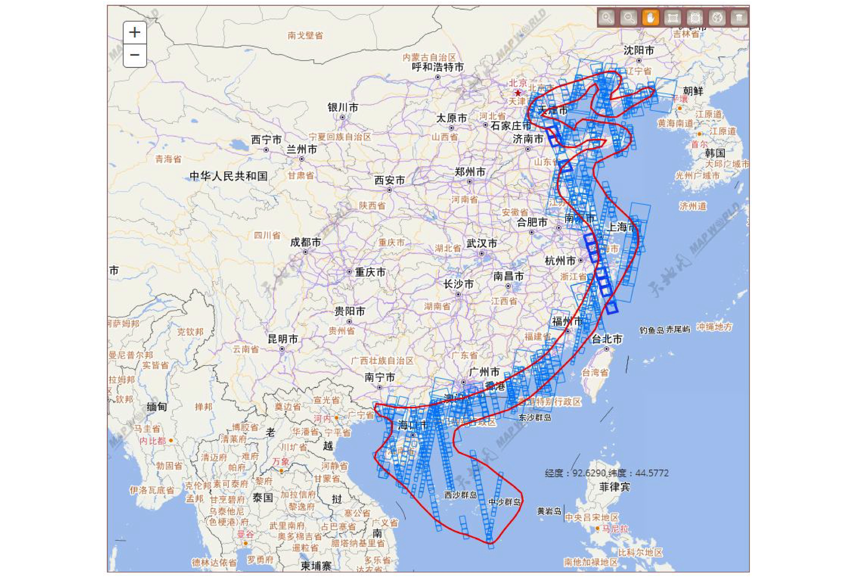
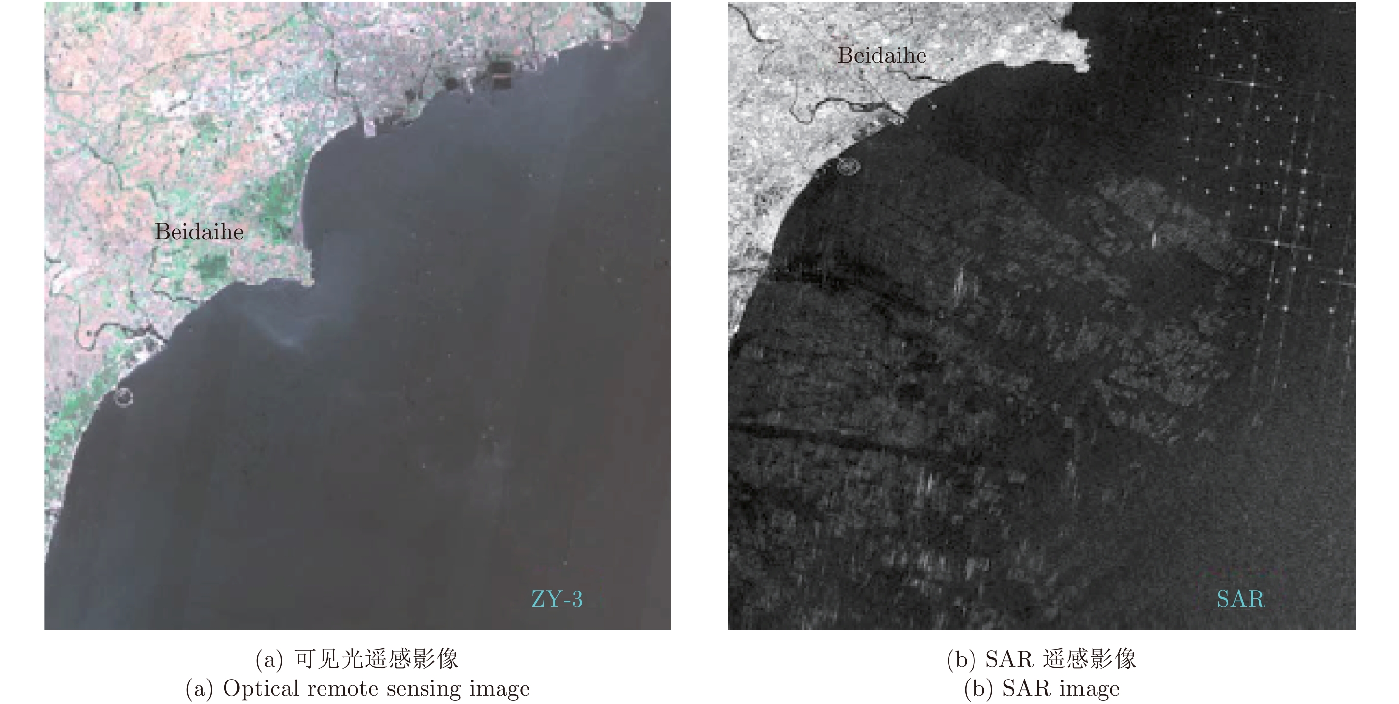
- Figure 2. GF-3 SAR data coverage of coastal area of China
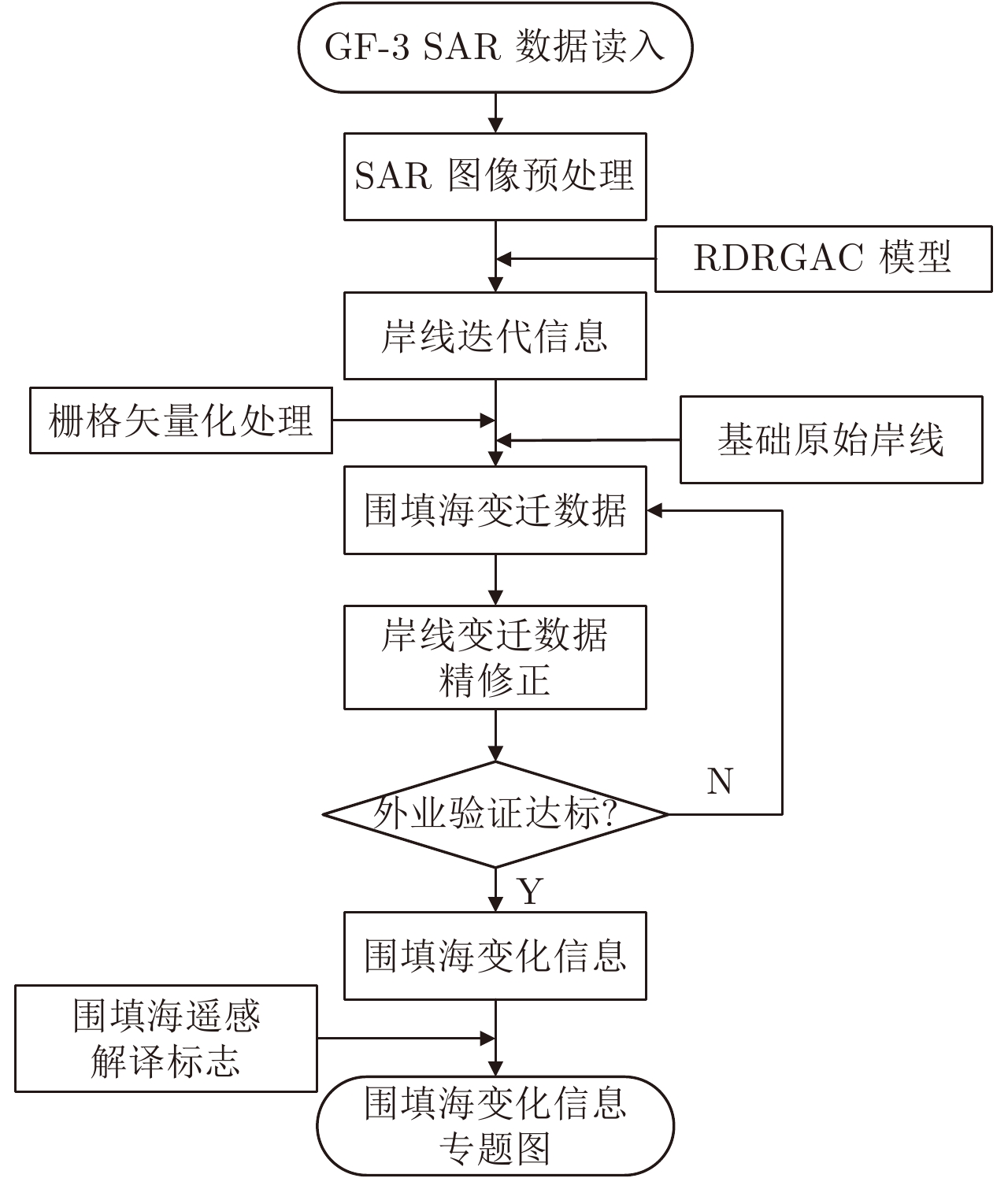
- Figure 3. Dynamic monitoring process flow chart of reclamation in SAR image
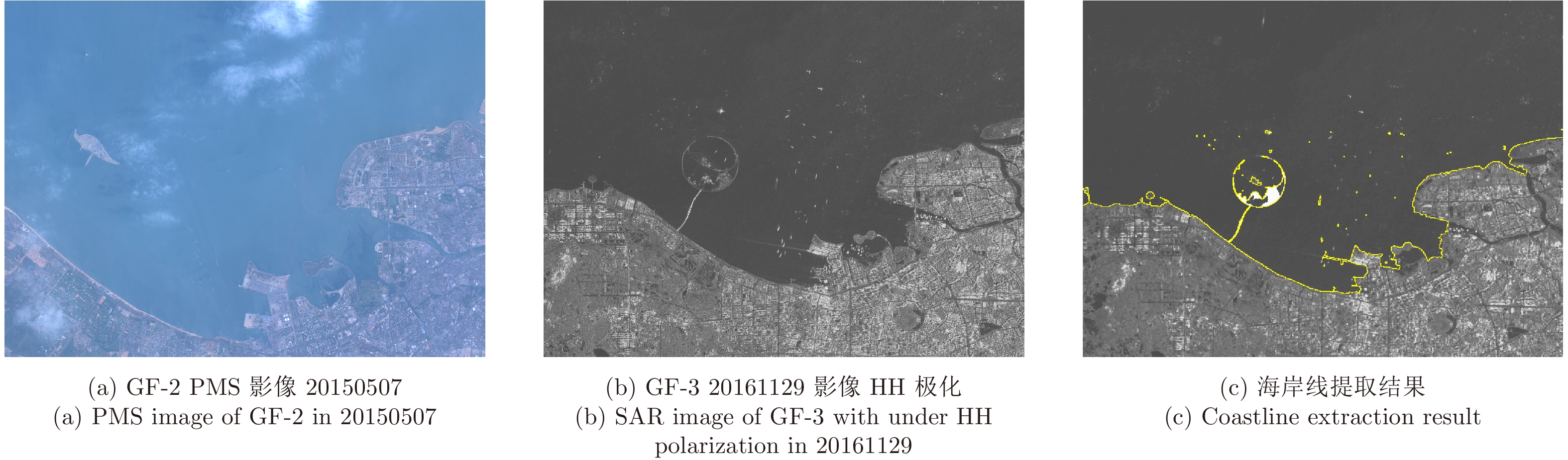
- Figure 4. The basic result of coastline extraction result of Haikou area
- Figure 5. Coastline information extraction according to dynamic monitoring process
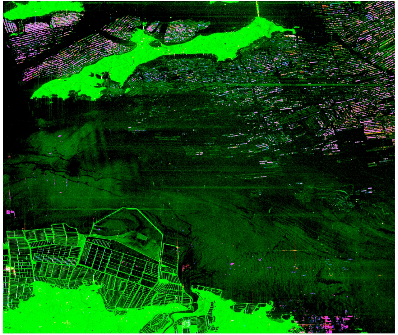
- Figure 6. Reclamation change thematic map of Jinzhou Bay in 2017
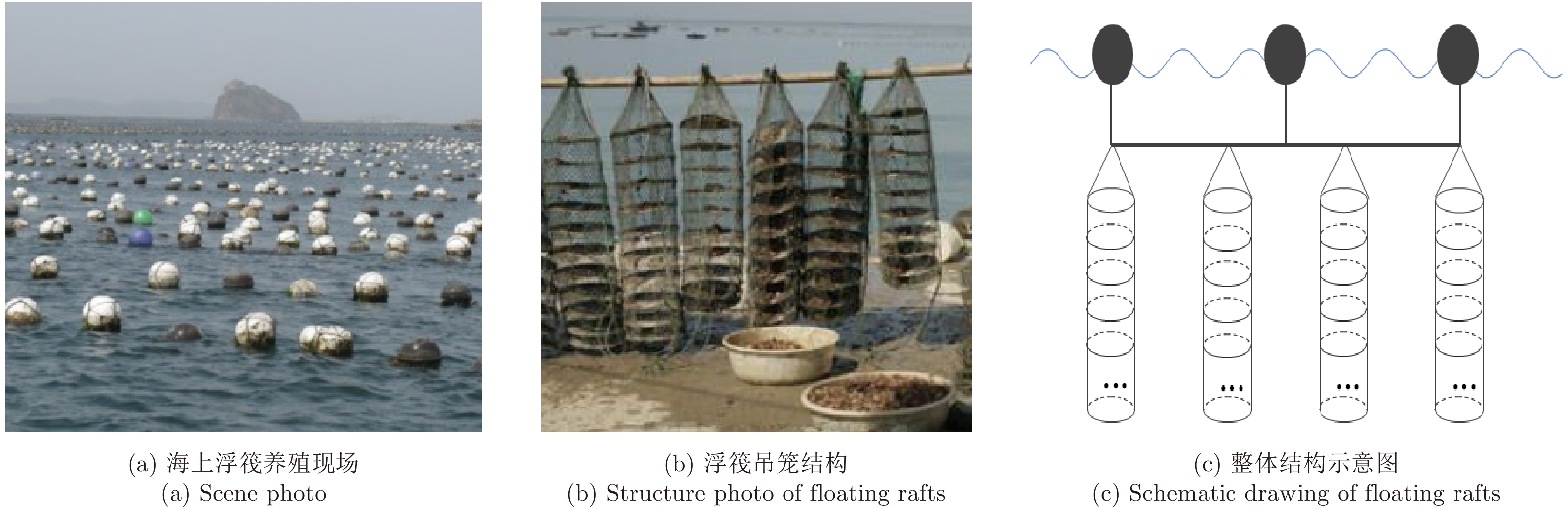
- Figure 7. Remote sensing image of floating raft
- Figure 8. Remote sensing image of floating raft
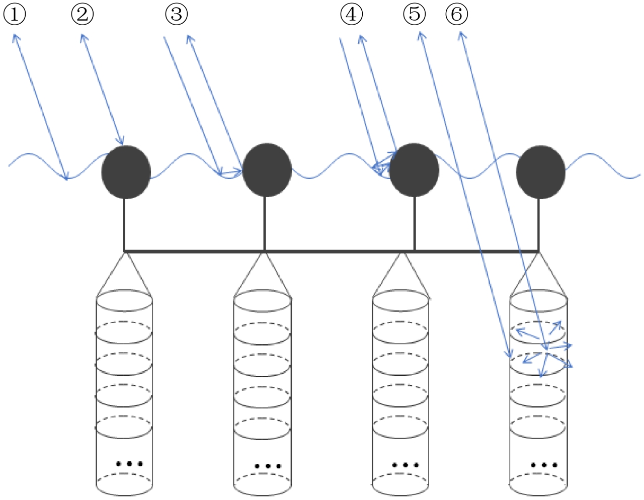
- Figure 9. Schematic diagram of floating raft aquaculture scattering mechanism (① Scattering method of sea surface, ② Scattering method of floating raft, ③ Scattering method of dihedral caused by raft and sea surface, ④ Scattering method of helix structure, ⑤ Scattering method of surface under water, ⑥ Scattering method of body under water)
- Figure 10. Polar decomposition of floating raft aquaculture in Japan
- Figure 11. Yamaguchi polar decomposition of floating raft aquaculture in Dalian
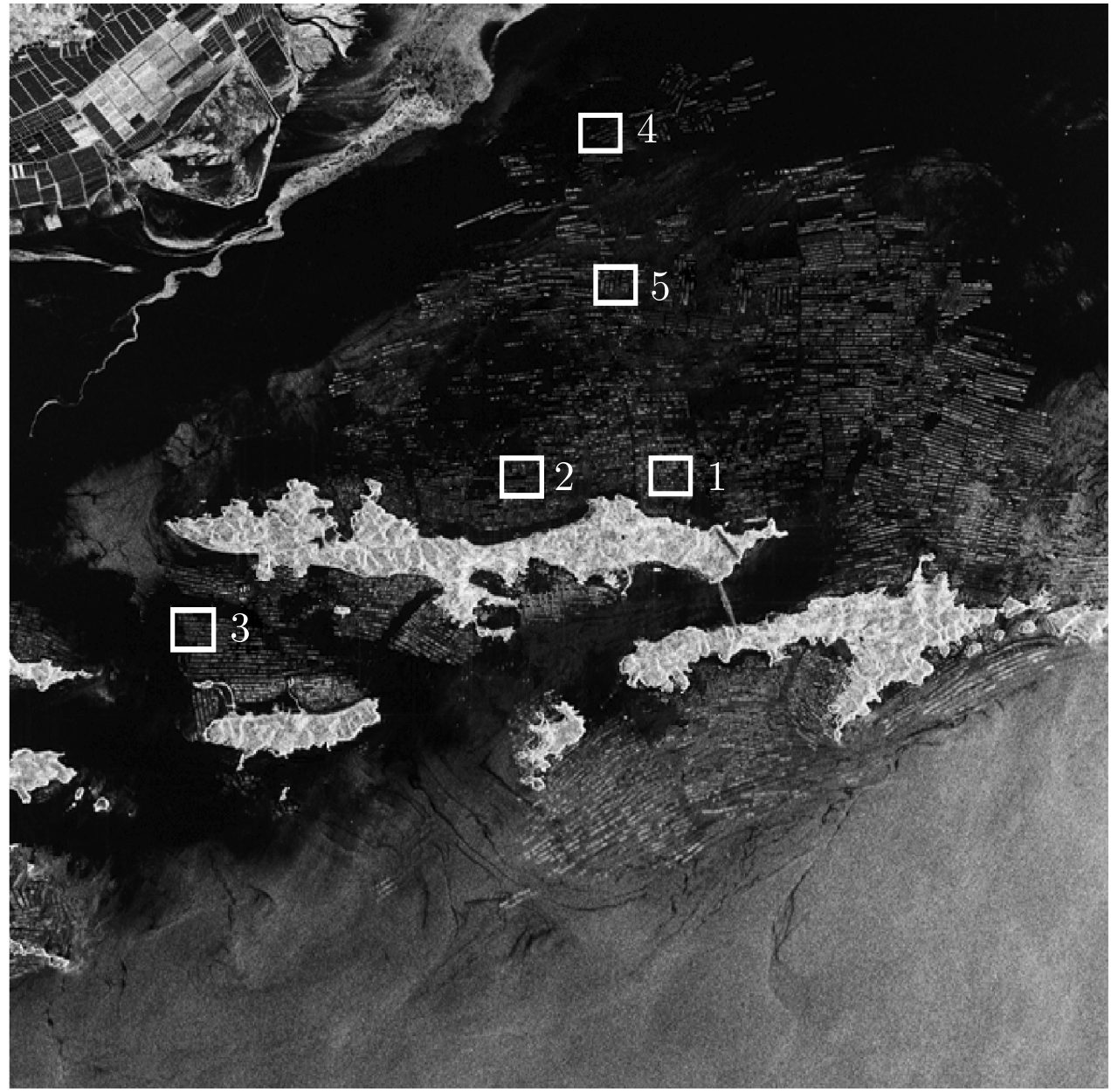
- Figure 12. Imagery of GF-3 slices
- Figure 13. Result based on GF-3 data slice 1
- Figure 14. Result based on GF-3 data slice 2
- Figure 15. Result of data slice 3 experiment
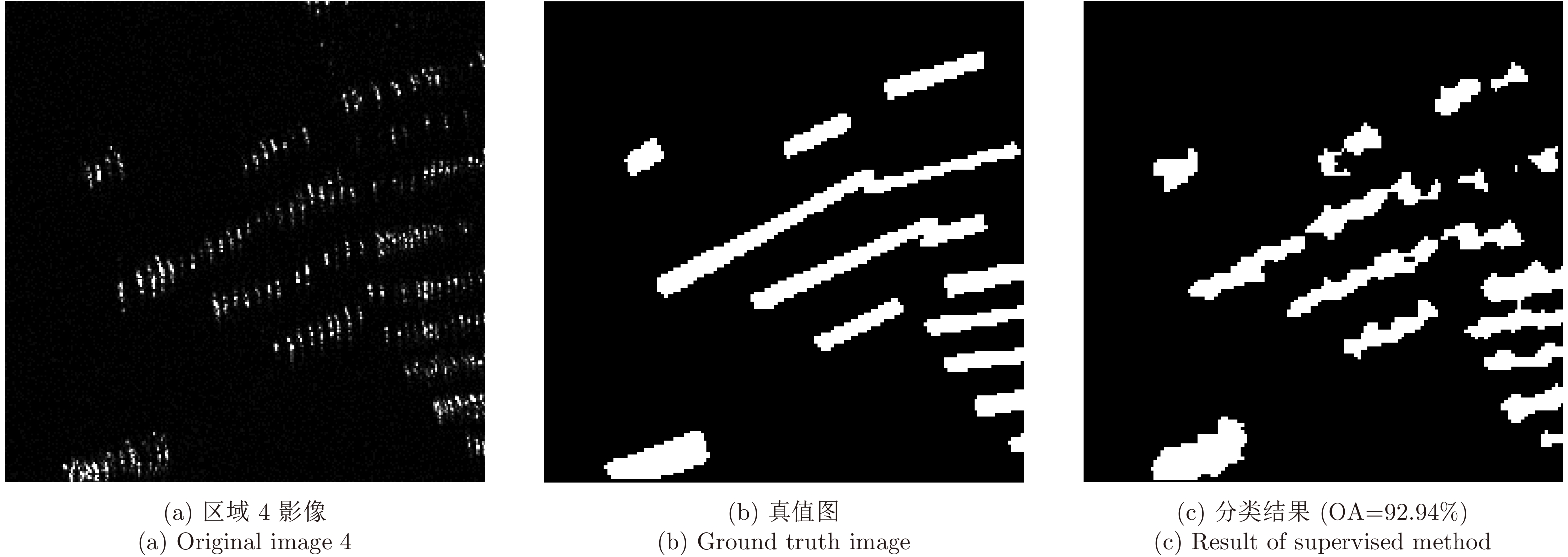
- Figure 16. Result of data slice 4 experiment
- Figure 17. Result of data slice 5 experiment
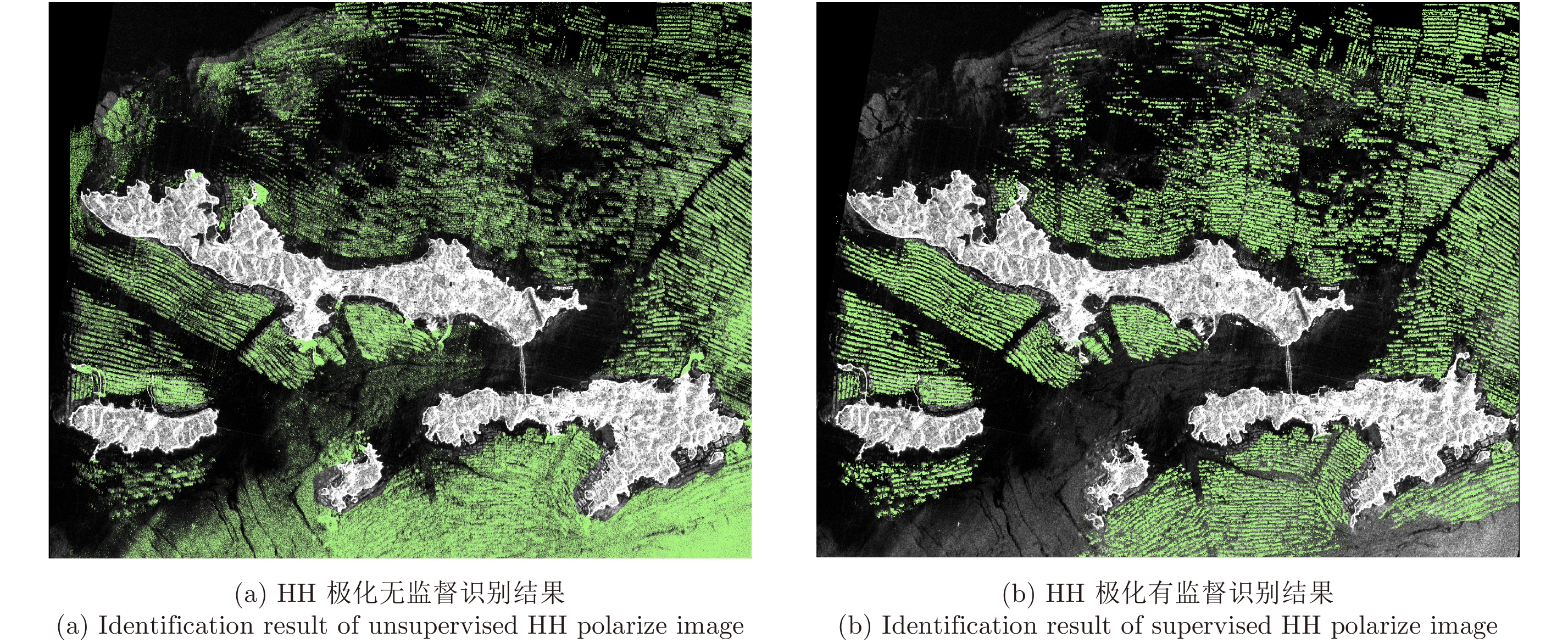
- Figure 18. Floating raft recognition result under full polarmetric mode Ⅰ
- Figure 19. Identification result of UFS floating raft