
 Submit Manuscript
 Peer Review
 Editor Work
- Home
- Articles & Issues
-
Data
- Dataset of Radar Detecting Sea
- SAR Dataset
- SARGroundObjectsTypes
- SARMV3D
- AIRSAT Constellation SAR Land Cover Classification Dataset
- 3DRIED
- UWB-HA4D
- LLS-LFMCWR
- FAIR-CSAR
- MSAR
- SDD-SAR
- FUSAR
- SpaceborneSAR3Dimaging
- Sea-land Segmentation
- SAR Multi-domain Ship Detection Dataset
- SAR-Airport
- Hilly and mountainous farmland time-series SAR and ground quadrat dataset
- SAR images for interference detection and suppression
- HP-SAR Evaluation & Analytical Dataset
- GDHuiYan-ATRNet
- Multi-System Maritime Low Observable Target Dataset
- DatasetinthePaper
- DatasetintheCompetition
- Report
- Course
- About
- Publish
- Editorial Board
- Chinese
| Citation: | XIAO Zhen, GU Yanfeng, JIANG Yanze, et al. Full-waveform small-footprint LiDAR multi-target echo waveform lightweight detection by spatio-temporal coupling models[J]. Journal of Radars, 2025, 14(3): 548–561. doi: 10.12000/JR24245

|
Full-waveform Small-footprint LiDAR Multi-target Echo Waveform Lightweight Detection by Spatio-temporal Coupling Models
DOI: 10.12000/JR24245 CSTR: 32380.14.JR24245
More Information-
Abstract
Small-footprint full-waveform Light Detection And Ranging (LiDAR) exhibits significant application potential owing to its high penetration capability and ability to capture complete echo data. However, the efficient and accurate processing of massive echo signals remains a crucial challenge for practical use, particularly in advancing waveform decomposition technology. In small-footprint full-waveform LiDAR systems, most echoes are single-target, while only multi-target echoes require detailed decomposition. Current solutions often sacrifice precision by employing simplified rapid waveform decomposition algorithms or process all echoes indiscriminately, resulting in low efficiency and the inability to balance accuracy and speed effectively. This study proposes a spatiotemporal coupling model-driven lightweight algorithm for detecting multi-target echoes in small-footprint full-waveform LiDAR. For the first time, it achieves efficient and accurate detection of multi-target echoes from waveform data with unknown echo counts. The proposed method eliminates redundant computations caused by indiscriminate processing of single-target echoes, significantly reducing waveform decomposition iterations. The technical contributions include constructing a spatiotemporal coupling echo signal model that captures the spatiotemporal characteristics of echo transmission, implementing model-driven lightweight waveform parameter estimation through double Gaussian function superposition fitting, and introducing an adaptive correlation discrimination method based on a signal-to-noise ratio approach. By leveraging the consistency of system-emitted pulses, the proposed method enables lightweight yet accurate multi-target echo detection. Experimental results on terrestrial and airborne waveform datasets demonstrate that our algorithm achieves 98.4% detection accuracy with a 93.1% recall rate. When integrated with four waveform decomposition methods, it improves processing efficiency by 2–3 times. The efficiency gain becomes even more pronounced as the proportion of single-target echoes increases. -

-
References
[1] GOETZ A F H. Imaging spectrometry for remote sensing: Vision to reality in 15 years[C]. The SPIE 2480, Imaging Spectrometry, Orlando, FL, United States, 1995: 2–13. doi: 10.1117/12.210867.[2] WEHR A and LOHR U. Airborne laser scanning—an introduction and overview[J]. ISPRS Journal of Photogrammetry and Remote Sensing, 1999, 54(2): 68–82. doi: 10.1016/S0924-2716(99)00011-8.[3] YOU R J and LIN B C. A quality prediction method for building model reconstruction using LiDAR data and topographic maps[J]. IEEE Transactions on Geoscience and Remote Sensing, 2011, 49(9): 3471–3480. doi: 10.1109/TGRS.2011.2128326.[4] GONZALEZ-AGUILERA D, CRESPO-MATELLAN E, HERNANDEZ-LOPEZ D, et al. Automated urban analysis based on LiDAR-derived building models[J]. IEEE Transactions on Geoscience and Remote Sensing, 2013, 51(3): 1844–1851. doi: 10.1109/TGRS.2012.2205931.[5] GUAN Hongcan, SU Yanjun, HU Tianyu, et al. A novel framework to automatically fuse multiplatform LiDAR data in forest environments based on tree locations[J]. IEEE Transactions on Geoscience and Remote Sensing, 2020, 58(3): 2165–2177. doi: 10.1109/TGRS.2019.2953654.[6] JI Xue, YANG Bisheng, WANG Yuan, et al. Full-waveform classification and segmentation-based signal detection of single-wavelength bathymetric LiDAR[J]. IEEE Transactions on Geoscience and Remote Sensing, 2022, 60: 1–14. doi: 10.1109/TGRS.2022.3198168.[7] GROLLIUS S, LIGGES M, RUSKOWSKI J, et al. Concept of an automotive LiDAR target simulator for direct time-of-flight LiDAR[J]. IEEE Transactions on Intelligent Vehicles, 2023, 8(1): 825–835. doi: 10.1109/TIV.2021.3128808.[8] MALLET C and BRETAR F. Full-waveform topographic LiDAR: State-of-the-art[J]. ISPRS Journal of Photogrammetry and Remote Sensing, 2009, 64(1): 1–16. doi: 10.1016/j.isprsjprs.2008.09.007.[9] 沈俊, 尚建华, 贺岩. 全波形机载激光雷达数据处理技术的研究进展[J]. 激光技术, 2018, 42(3): 295–299. doi: 10.7510/jgjs.issn.1001-3806.2018.03.002.SHEN Jun, SHANG Jianhua, and HE Yan. Research process of data processing technology of full-waveform airborne laser radars[J]. Laser Technology, 2018, 42(3): 295–299. doi: 10.7510/jgjs.issn.1001-3806.2018.03.002.[10] ZHANG Zhengnan, CAO Lin, LIU Hao, et al. Assessing the 3-D structure of bamboo forests using an advanced pseudo-vertical waveform approach based on airborne full-waveform LiDAR data[J]. IEEE Transactions on Geoscience and Remote Sensing, 2021, 59(12): 10647–10670. doi: 10.1109/TGRS.2020.3042790.[11] GAO Shuai, NIU Zheng, SUN Gang, et al. Height extraction of maize using airborne full-waveform LIDAR data and a deconvolution algorithm[J]. IEEE Geoscience and Remote Sensing Letters, 2015, 12(9): 1978–1982. doi: 10.1109/LGRS.2015.2441655.[12] YANG Fanlin, CHAO Qi, SU Dianpeng, et al. An airborne LiDAR bathymetric waveform decomposition method in very shallow water: A case study around Yuanzhi Island in the South China Sea[J]. International Journal of Applied Earth Observation and Geoinformation, 2022, 109: 102788. doi: 10.1016/j.jag.2022.102788.[13] RiUNITE[OL]. http://www.riegl.com/products/software-packages/riunite/.[14] WANG Zining, XU Lijun, LI Duan, et al. Online multi-target laser ranging using waveform decomposition on FPGA[J]. IEEE Sensors Journal, 2021, 21(9): 10879–10889. doi: 10.1109/JSEN.2021.3060158.[15] LIU Gangping and KE Jun. End-to-end full-waveform echo decomposition based on self-attention classification and U-Net decomposition[J]. IEEE Journal of Selected Topics in Applied Earth Observations and Remote Sensing, 2022, 15: 7978–7987. doi: 10.1109/JSTARS.2022.3203130.[16] WANG Cheng, YANG Xuebo, XI Xiaohuan, et al. Introduction to LiDAR Remote Sensing[M]. Boca Raton: CRC Press, 2024: 26–29. doi: 10.1201/9781032671512.[17] MOUNTRAKIS G and LI Yuguang. A linearly approximated iterative Gaussian decomposition method for waveform LiDAR processing[J]. ISPRS Journal of Photogrammetry and Remote Sensing, 2017, 129: 200–211. doi: 10.1016/j.isprsjprs.2017.05.009.[18] ZHOU Guoqing, LONG Shuhua, XU Jiasheng, et al. Comparison analysis of five waveform decomposition algorithms for the airborne LiDAR echo signal[J]. IEEE Journal of Selected Topics in Applied Earth Observations and Remote Sensing, 2021, 14: 7869–7880. doi: 10.1109/JSTARS.2021.3096197.[19] ZHOU Guoqing, DENG Ronghua, ZHOU Xiang, et al. Gaussian inflection point selection for LiDAR hidden echo signal decomposition[J]. IEEE Geoscience and Remote Sensing Letters, 2022, 19: 1–5. doi: 10.1109/LGRS.2021.3107438.[20] ZHOU Tan, POPESCU S C, KRAUSE K, et al. Gold—A novel deconvolution algorithm with optimization for waveform LiDAR processing[J]. ISPRS Journal of Photogrammetry and Remote Sensing, 2017, 129: 131–150. doi: 10.1016/j.isprsjprs.2017.04.021.[21] LIU Chang, XU Lijun, SI Lin, et al. A robust deconvolution method of airborne LiDAR waveforms for dense point clouds generation in forest[J]. IEEE Transactions on Geoscience and Remote Sensing, 2022, 60: 1–14. doi: 10.1109/TGRS.2021.3061166.[22] XIAO Zhen, GU Yanfeng, LI Xian, et al. Application of landweber with optimization for small footprint waveform lidar decomposition[C]. IGARSS 2024 - 2024 IEEE International Geoscience and Remote Sensing Symposium, Athens, Greece, 2024: 6408–6411. doi: 10.1109/IGARSS53475.2024.10640890.[23] WANG Binhui, SONG Shalei, SHI Shuo, et al. Multichannel interconnection decomposition for hyperspectral LiDAR waveforms detected from over 500 m[J]. IEEE Transactions on Geoscience and Remote Sensing, 2022, 60: 5515714. doi: 10.1109/TGRS.2021.3108160.[24] SONG Shalei, WANG Binhui, GONG Wei, et al. A new waveform decomposition method for multispectral LiDAR[J]. ISPRS Journal of Photogrammetry and Remote Sensing, 2019, 149: 40–49. doi: 10.1016/j.isprsjprs.2019.01.014.[25] BAI Jie, NIU Zheng, BI Kaiyi, et al. Toward an advanced method for full-waveform hyperspectral LiDAR data processing[J]. IEEE Transactions on Geoscience and Remote Sensing, 2024, 62: 5702516. doi: 10.1109/TGRS.2024.3382481.[26] BAI Jie, NIU Zheng, HUANG Yanru, et al. Full-waveform hyperspectral LiDAR data decomposition via ranking central locations of natural target echoes (Rclonte) at different wavelengths[J]. Remote Sensing of Environment, 2024, 310: 114227. doi: 10.1016/j.rse.2024.114227.[27] XIA Yuhao, XU Shilong, SHAO Hui, et al. Range resolution enhanced method with spectral properties for hyperspectral LiDAR[J]. IEEE Transactions on Geoscience and Remote Sensing, 2023, 61: 5703517. doi: 10.1109/TGRS.2023.3301896.[28] XU Fan, LI Fenfang, and WANG Yuanqing. Modified levenberg-marquardt-based optimization method for LiDAR waveform decomposition[J]. IEEE Geoscience and Remote Sensing Letters, 2016, 13(4): 530–534. doi: 10.1109/LGRS.2016.2522387. -
Proportional views


- Publishing Ethics
- Journal Insights
- Abstracting & Indexing
- Peer Review Policies
- Guide for Authors
- Conference
- ISSN 2095-283X (Print)ISSN 2097-339X (Online)
- CN 10-1030/TN
- CODEN LXEUAO
About Journal
- Sponsor: China Radio Detection and Ranging Industry Association (CRIA)
- Phone: 010-58887062
- Email:radars@aircas.ac.cn
- Publisher: Leida Xuebao Bianjibu (Editorial office of the Journal of Radars)
Contacts Us

京ICP备20021838号-14
Supported by: Beijing Renhe Information Technology Co. Ltd

Export File
Citation
Format
Content
 DownLoad:

- Figure 1. Multi-target waveform detection algorithm flow chart (the dark grey boxes are the key steps)
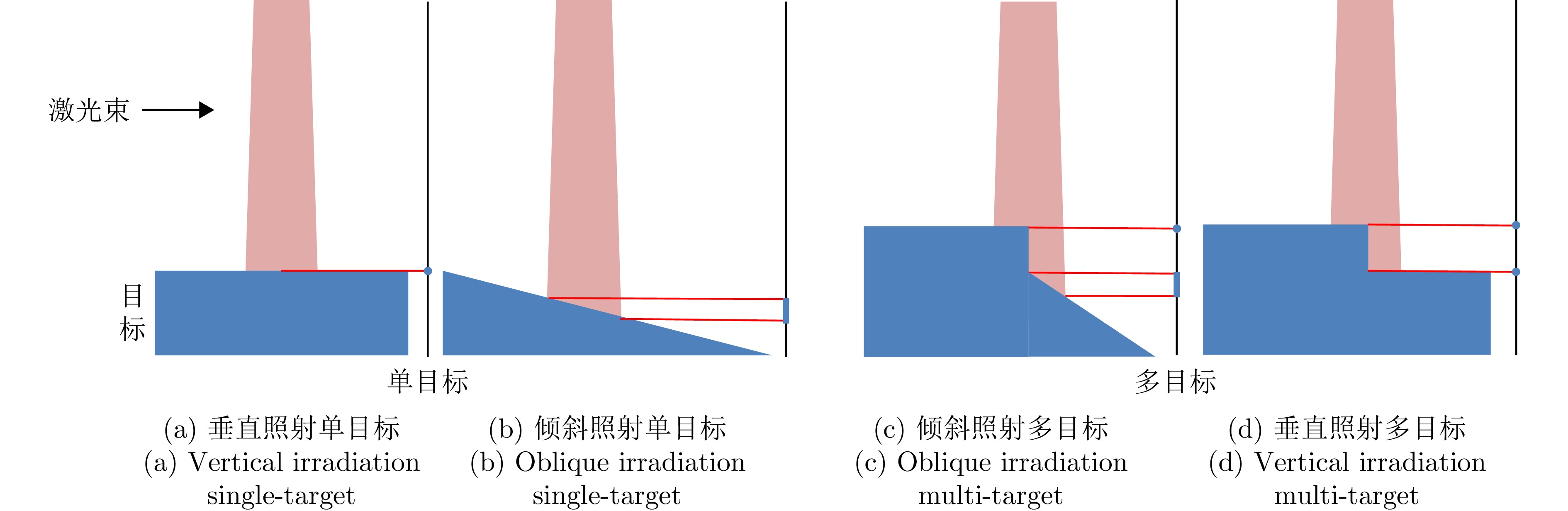
- Figure 2. Schematic diagram of laser beam illuminating target
- Figure 3. Schematic diagram of data acquisition
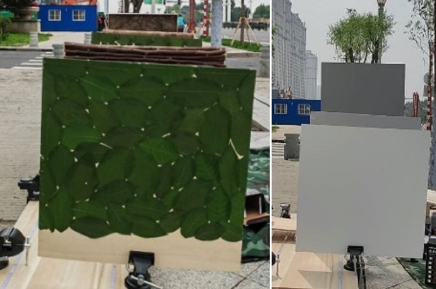
- Figure 4. Schematic of multi-target waveform selection for ground data
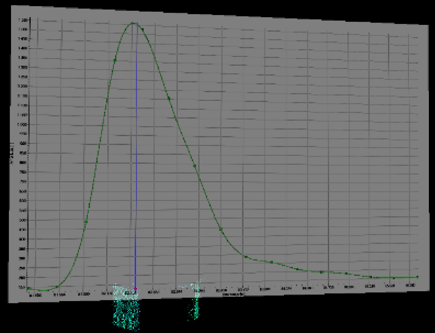
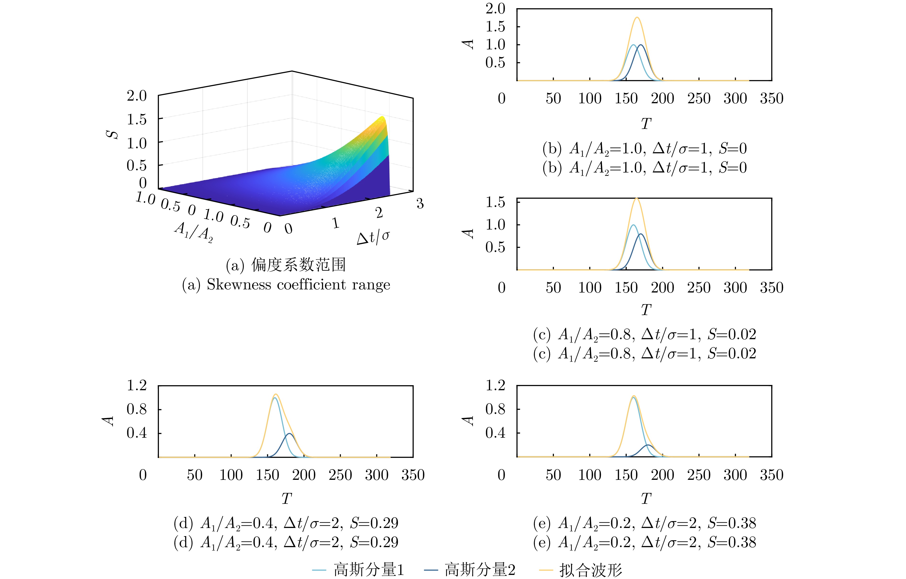
- Figure 5. Distribution diagram of skewness coefficient and fitting waveform diagram
- Figure 6. Comparison of VZ 2000 transmitted pulses fitted by single Gaussian function and double Gaussian function
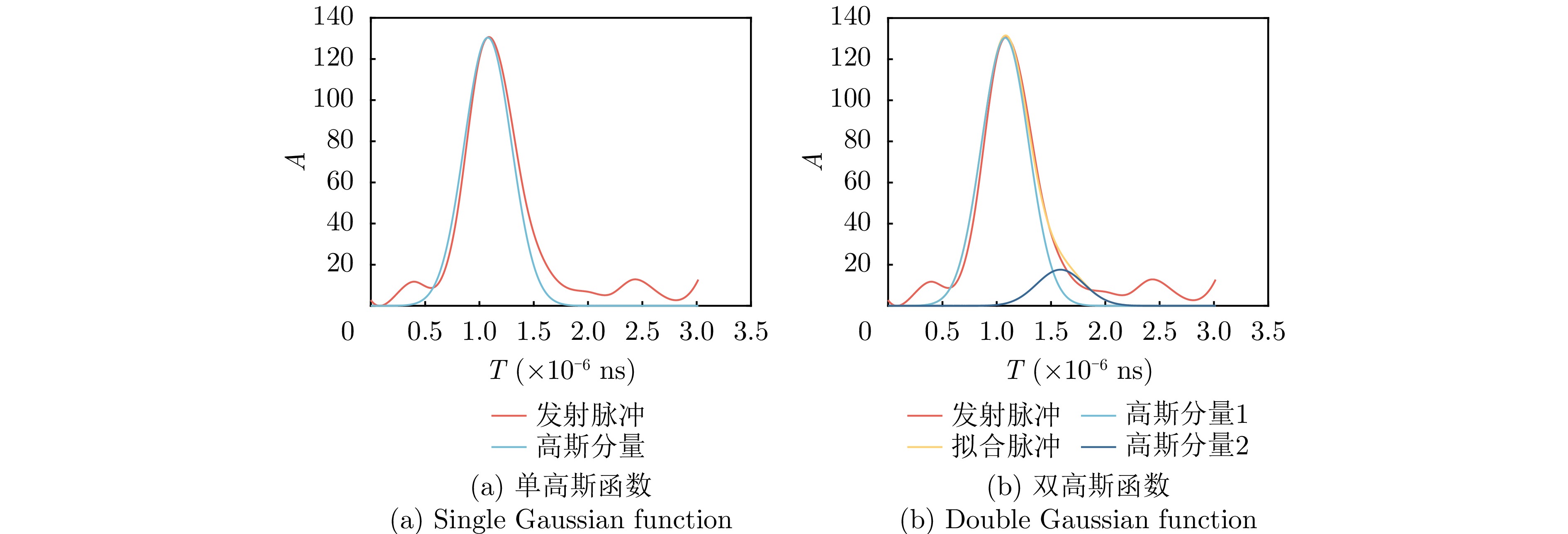
- Figure 7. Comparison of Optech Gemini transmitted pulses fitted by single Gaussian function and double Gaussian function
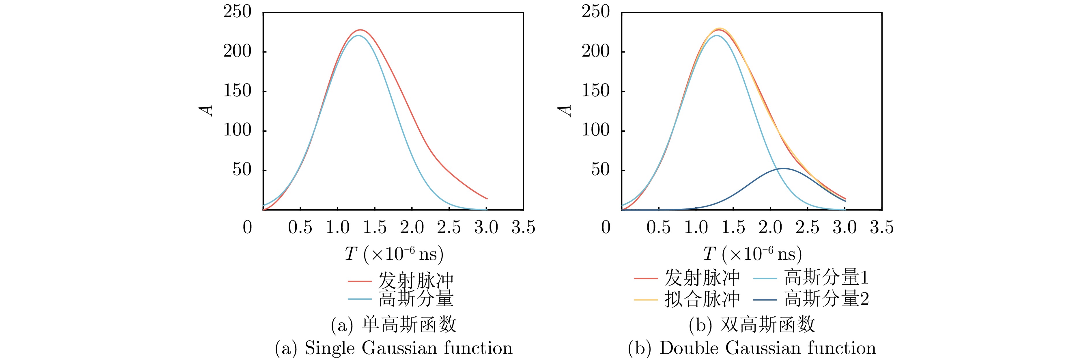
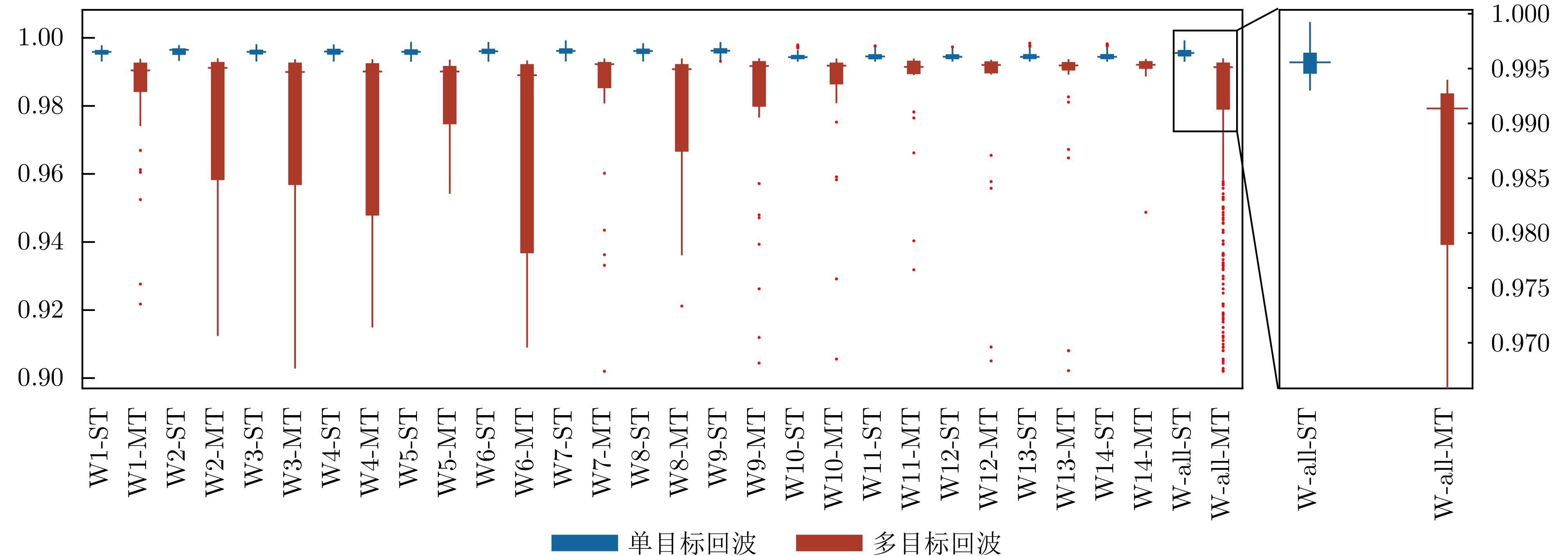
- Figure 8. Correlation distinction between single-target waveforms and multi-target waveforms
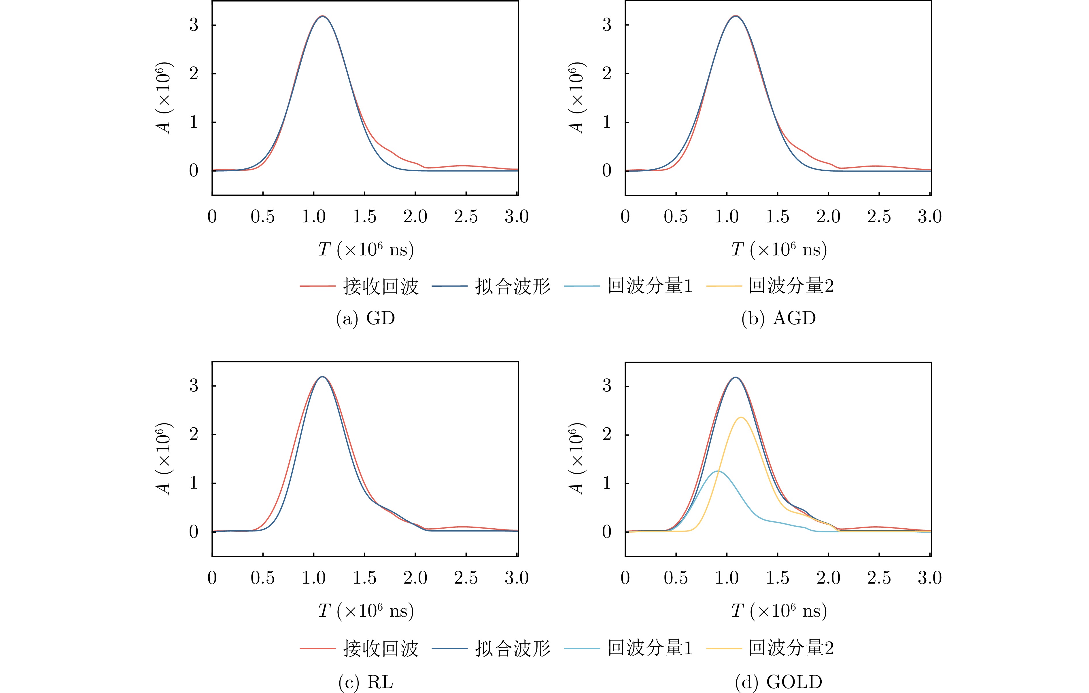
- Figure 9. Diagram of waveform decomposition results
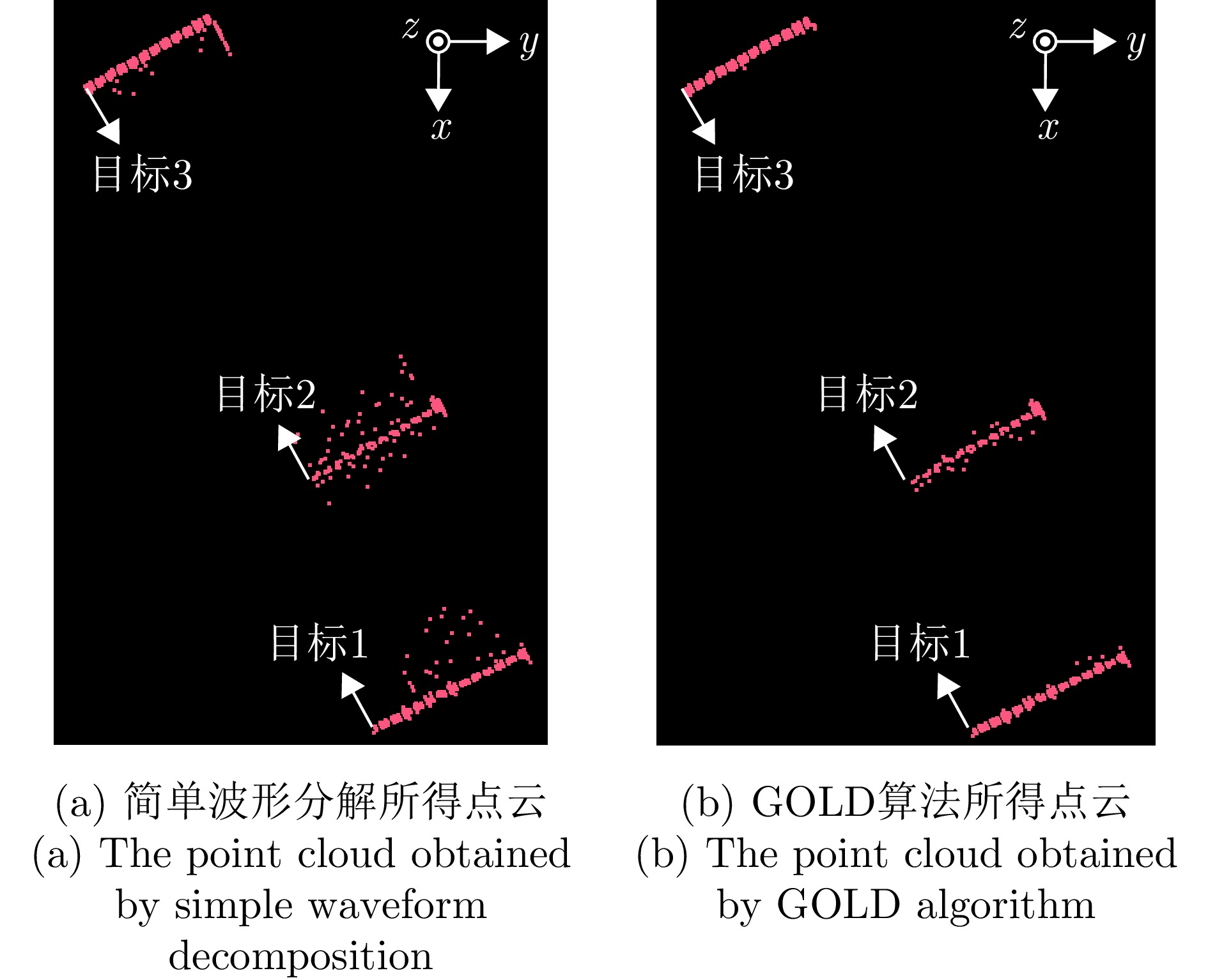
- Figure 10. Schematic diagram of airborne data point cloud
- Figure 11. Schematic diagram of airborne data point cloud
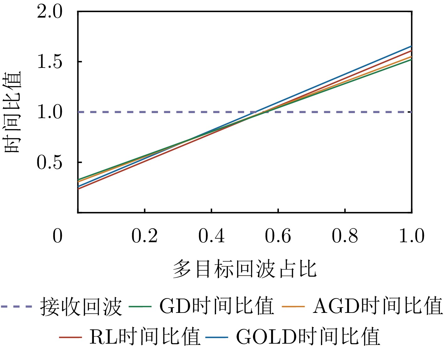
- Figure 12. Relation between multi-target waveform proportion and waveform processing time in terrain data