
 Submit Manuscript
 Peer Review
 Editor Work
- Home
- Articles & Issues
-
Data
- Dataset of Radar Detecting Sea
- SAR Dataset
- SARGroundObjectsTypes
- SARMV3D
- AIRSAT Constellation SAR Land Cover Classification Dataset
- 3DRIED
- UWB-HA4D
- LLS-LFMCWR
- FAIR-CSAR
- MSAR
- SDD-SAR
- FUSAR
- SpaceborneSAR3Dimaging
- Sea-land Segmentation
- SAR Multi-domain Ship Detection Dataset
- SAR-Airport
- Hilly and mountainous farmland time-series SAR and ground quadrat dataset
- SAR images for interference detection and suppression
- HP-SAR Evaluation & Analytical Dataset
- GDHuiYan-ATRNet
- Multi-System Maritime Low Observable Target Dataset
- DatasetinthePaper
- DatasetintheCompetition
- Report
- Course
- About
- Publish
- Editorial Board
- Chinese
| Citation: | SHAO Hui, ZHANG Hulong, DAI Hui, et al. Fast reflectance spectral profile reconstruction method for full-waveform hyperspectral LiDAR[J]. Journal of Radars, 2025, 14(3): 602–615. doi: 10.12000/JR24214

|
Fast Reflectance Spectral Profile Reconstruction Method for Full-waveform Hyperspectral LiDAR
DOI: 10.12000/JR24214 CSTR: 32380.14.JR24214
More Information-
Abstract
Hyperspectral LiDAR (HSL) can obtain high precision and resolution spatial data along with the spectral information of the target, which can provide effective and multidimensional data for various research and application fields. However, differences in transmitting signal intensities of HSL at various wavelengths lead to variations in corresponding echo intensities, making it challenging to directly reconstruct accurate optical characteristics (reflectance spectral profile) of the target with echo intensities. To obtain the target reflectance spectral profile, a common solution is to correct the echo intensity (standard reference correction method) using standard diffuse reflectance whiteboards. However, in complex detection environments, whiteboards are susceptible to contamination, and the transmitting intensity of the laser may fluctuate due to changes in the environment and equipment conditions, which may potentially impact the calculation accuracy. The direct transmission of information from the full-waveform signals to the reconstruction of the reflectance spectral profiles is a more efficient approach. Therefore, we propose an echo intensity correction method based on HSL full-waveform data for the rapid generation of reflectance spectral profiles of targets. The initial step is to conduct a theoretical analysis that illustrates the similarity between the echo signals and the transmitting signals in terms of their waveforms. A skew-normal Gaussian function is then employed to fit the transmitting and echo signals of the HSL full waveform. Thereafter, the transmit-to-echo signal peak ratios (normalization factors) of the standard diffuse reflectance whiteboard at different wavelengths are calculated under ideal conditions. Finally, the reflectance spectral profile of the target is constructed by combining the normalization factor of the standard diffuse reflectance whiteboard with that of the target. To verify the effectiveness of the proposed method, we conducted experiments to compare the reflectance spectral profiles calculated using the standard reference correction method. Moreover, we performed wood-leaf separation and target classification experiments to assess its reliability and usability. The experimental results reveal the following: (1) The reconstructed reflectance spectral profiles of the target can be obtained by correcting the echo intensity with the transmitting signals, which is similar to that obtained by the standard reference correction method. Moreover, it demonstrates excellent stability under various temperatures and lighting conditions. Compared with the standard reference correction method, this approach effectively overcomes the influence of laser emission energy fluctuations, thereby considerably improving the measurement accuracy and consistency of reflectance spectral curves, especially under prolonged HSL operation conditions. (2) The wood-leaf separation and the multiple target classification can be conducted using the reconstructed target reflectance spectral profiles, with a classification accuracy of over 90%. Overall, the proposed method simplifies the correction of echo intensity for full-waveform HSL, which is suitable for the rapid reconstruction of target hyperspectral information during data acquisition. -

-
References
[1] WANG Junbo, WANG Lanying, FENG Shufang, et al. An overview of shoreline mapping by using airborne LiDAR[J]. Remote Sensing, 2023, 15(1): 253. doi: 10.3390/rs15010253.[2] HU Tianyu, SUN Xiliang, SU Yanjun, et al. Development and performance evaluation of a very low-cost UAV-LiDAR system for forestry applications[J]. Remote Sensing, 2020, 13(1): 77. doi: 10.3390/rs13010077.[3] CASPARI G. The potential of new LiDAR datasets for archaeology in Switzerland[J]. Remote Sensing, 2023, 15(6): 1569. doi: 10.3390/rs15061569.[4] MILENKOVIĆ M, WAGNER W, QUAST R, et al. Total canopy transmittance estimated from small-footprint, full-waveform airborne LiDAR[J]. ISPRS Journal of Photogrammetry and Remote Sensing, 2017, 128: 61–72. doi: 10.1016/j.isprsjprs.2017.03.008.[5] SUN Jia, SHI Shuo, YANG Jian, et al. Wavelength selection of the multispectral lidar system for estimating leaf chlorophyll and water contents through the PROSPECT model[J]. Agricultural and Forest Meteorology, 2019, 266/267: 43–52. doi: 10.1016/j.agrformet.2018.11.035.[6] WALLACE A M, MCCARTHY A, NICHOL C J, et al. Design and evaluation of multispectral LiDAR for the recovery of arboreal parameters[J]. IEEE Transactions on Geoscience and Remote Sensing, 2014, 52(8): 4942–4954. doi: 10.1109/TGRS.2013.2285942.[7] QI Baoling, YANG Guohui, ZHANG Yu, et al. Target intensity correction method based on incidence angle and distance for a pulsed Lidar system[J]. Applied Optics, 2024, 63(10): A86–A97. doi: 10.1364/AO.505690.[8] 白杰, 牛铮, 毕恺艺, 等. 高光谱激光雷达植被叶片方向反射特性及对叶绿素反演的影响[J]. 光谱学与光谱分析, 2023, 43(5): 1598–1605. doi: 10.3964/j.issn.1000-0593(2023)05-1598-08.BAI Jie, NIU Zheng, BI Kaiyi, et al. Bi-directional reflection characteristic of vegetation leaf measured by hyperspectral LiDAR and its impact on chlorophyll content estimation[J]. Spectroscopy and Spectral Analysis, 2023, 43(5): 1598–1605. doi: 10.3964/j.issn.1000-0593(2023)05-1598-08.[9] BAI Jie, NIU Zheng, and LI Wang. A theoretical demonstration on the independence of distance and incidence angle effects for small-footprint hyperspectral LiDAR: Basic physical concepts[J]. Remote Sensing of Environment, 2024, 315: 114452. doi: 10.1016/j.rse.2024.114452.[10] HÖFLE B and PFEIFER N. Correction of laser scanning intensity data: Data and model-driven approaches[J]. ISPRS Journal of Photogrammetry and Remote Sensing, 2007, 62(6): 415–433. doi: 10.1016/j.isprsjprs.2007.05.008.[11] 刘伟东, 项月琴, 郑兰芬, 等. 高光谱数据与水稻叶面积指数及叶绿素密度的相关分析[J]. 遥感学报, 2000, 21(4): 279–283. doi: 10.11834/jrs.20000407.LIU Weidong, XIANG Yueqin, ZHENG Lanfen, et al. Relationships between rice LAI, CH.D and hyperspectral data[J]. Journal of Remote Sensing, 2000, 21(4): 279–283. doi: 10.11834/jrs.20000407.[12] BAI Jie, NIU Zheng, GAO Shuai, et al. An exploration, analysis, and correction of the distance effect on terrestrial hyperspectral LiDAR data[J]. ISPRS Journal of Photogrammetry and Remote Sensing, 2023, 198: 60–83. doi: 10.1016/j.isprsjprs.2023.03.001.[13] TIAN Wenxin, TANG Lingli, CHEN Yuwei, et al. Analysis and radiometric calibration for backscatter intensity of hyperspectral LiDAR caused by incident angle effect[J]. Sensors, 2021, 21(9): 2960. doi: 10.3390/s21092960.[14] BAI Jie, GAO Shuai, NIU Zheng, et al. A novel algorithm for leaf incidence angle effect correction of hyperspectral LiDAR[J]. IEEE Transactions on Geoscience and Remote Sensing, 2022, 60: 5700409. doi: 10.1109/TGRS.2021.3070652.[15] QIAN Xu, YANG Jian, SHI Shuo, et al. Analyzing the effect of incident angle on echo intensity acquired by hyperspectral lidar based on the Lambert-Beckman model[J]. Optics Express, 2021, 29(7): 11055–11069. doi: 10.1364/OE.420468.[16] ZHU Xi, WANG Tiejun, DARVISHZADEH R, et al. 3D leaf water content mapping using terrestrial laser scanner backscatter intensity with radiometric correction[J]. ISPRS Journal of Photogrammetry and Remote Sensing, 2015, 110: 14–23. doi: 10.1016/j.isprsjprs.2015.10.001.[17] NEVALAINEN O, HAKALA T, SUOMALAINEN J, et al. Fast and nondestructive method for leaf level chlorophyll estimation using hyperspectral LiDAR[J]. Agricultural and Forest Meteorology, 2014, 198/199: 250–258. doi: 10.1016/j.agrformet.2014.08.018.[18] NEVALAINEN O, HAKALA T, SUOMALAINEN J, et al. Nitrogen concentration estimation with hyperspectral LiDAR[J]. ISPRS Annals of the Photogrammetry, Remote Sensing and Spatial Information Sciences, 2013, II-5/W2: 205–210. doi: 10.5194/isprsannals-II-5-W2-205-2013.[19] SANKEY T, DONAGER J, MCVAY J, et al. UAV lidar and hyperspectral fusion for forest monitoring in the southwestern USA[J]. Remote Sensing of Environment, 2017, 195: 30–43. doi: 10.1016/j.rse.2017.04.007.[20] HURTT G C, DUBAYAH R, DRAKE J, et al. Beyond potential vegetation: Combining lidar data and a height‐structured model for carbon studies[J]. Ecological Applications, 2004, 14(3): 873–883. doi: 10.1890/02-5317.[21] THOMAS V, MCCAUGHEY J H, TREITZ P, et al. Spatial modelling of photosynthesis for a boreal mixedwood forest by integrating micrometeorological, lidar and hyperspectral remote sensing data[J]. Agricultural and Forest Meteorology, 2009, 149(3/4): 639–654. doi: 10.1016/j.agrformet.2008.10.016.[22] BAUER S and LEÓN F P. Spectral and geometric aspects of mineral identification by means of hyperspectral fluorescence imaging[J]. tm-Technisches Messen, 2015, 82(12): 597–605. doi: 10.1515/teme-2015-0039.[23] ZHANG Huijing, ZHOU Mei, WU Haohao, et al. Application of high-precision matching about multisensor in fast stereo imaging[C]. Sensors, Systems, and Next-Generation Satellites XIX, Toulouse, France, 2015: 606–612. doi: 10.1117/12.2194909.[24] GAULTON R, DANSON F M, RAMIREZ F A, et al. The potential of dual-wavelength laser scanning for estimating vegetation moisture content[J]. Remote Sensing of Environment, 2013, 132: 32–39. doi: 10.1016/j.rse.2013.01.001.[25] MARK D F, SASSE F, and SCHOFIELD L A. Spectral and spatial information from a novel dual-wavelength full-waveform terrestrial laser scanner for forest ecology[J]. Interface Focus, 2018, 8(2): 20170049. doi: 10.1098/rsfs.2017.0049.[26] EITE J U H, MAGNEY T S, VIERLING L A, et al. Assessment of crop foliar nitrogen using a novel dual-wavelength laser system and implications for conducting laser-based plant physiology[J]. ISPRS Journal of Photogrammetry and Remote Sensing, 2014, 97: 229–240. doi: 10.1016/j.isprsjprs.2014.09.009.[27] DANSON F M, GAULTON R, ARMITAGE R P, et al. Developing a dual-wavelength full-waveform terrestrial laser scanner to characterize forest canopy structure[J]. Agricultural and Forest Meteorology, 2014, 198/199: 7–14. doi: 10.1016/j.agrformet.2014.07.007.[28] CHEN Biwu, SHI Shuo, GONG Wei, et al. Multispectral LiDAR point cloud classification: A two-step approach[J]. Remote Sensing, 2017, 9(4): 373. doi: 10.3390/rs9040373.[29] ZHANG Changsai, GAO Shuai, LI Wang, et al. Radiometric calibration for incidence angle, range and sub-footprint effects on hyperspectral LiDAR backscatter intensity[J]. Remote Sensing, 2020, 12(17): 2855. doi: 10.3390/rs12172855.[30] CHEN Yuwei, LI Wei, HYYPPÄ J, et al. A 10-nm spectral resolution hyperspectral LiDAR system based on an acousto-optic tunable filter[J]. Sensors, 2019, 19(7): 1620. doi: 10.3390/s19071620.[31] SHAO Hui, CHEN Yuwei, YANG Zhirong, et al. A 91-channel hyperspectral LiDAR for coal/rock classification[J]. IEEE Geoscience and Remote Sensing Letters, 2020, 17(6): 1052–1056. doi: 10.1109/LGRS.2019.2937720.[32] SHAO Hui, CHEN Yuwei, LI Wei, et al. An investigation of spectral band selection for hyperspectral LiDAR technique[J]. Electronics, 2020, 9(1): 148. doi: 10.3390/electronics9010148.[33] SUN Jia, SHI Shuo, YANG Jian, et al. Estimating leaf chlorophyll status using hyperspectral lidar measurements by PROSPECT model inversion[J]. Remote Sensing of Environment, 2018, 212: 1–7. doi: 10.1016/j.rse.2018.04.024.[34] CHEN Bowen, SHI Shuo, GONG Wei, et al. True-color three-dimensional imaging and target classification based on hyperspectral LiDAR[J]. Remote Sensing, 2019, 11(13): 1541. doi: 10.3390/rs11131541.[35] BI Kaiyi, XIAO Shunfu, GAO Shuai, et al. Estimating vertical chlorophyll concentrations in maize in different health states using hyperspectral LiDAR[J]. IEEE Transactions on Geoscience and Remote Sensing, 2020, 58(11): 8125–8133. doi: 10.1109/TGRS.2020.2987436.[36] SHAO Hui, CAO Zheng, LI Wei, et al. Feasibility study of wood-leaf separation based on hyperspectral LiDAR technology in indoor circumstances[J]. IEEE Journal of Selected Topics in Applied Earth Observations and Remote Sensing, 2022, 15: 729–738. doi: 10.1109/JSTARS.2021.3134651.[37] SHAO Hui, ZHANG Hulong, HU Peilun, et al. Feasibility study of forest wood-boring pest detection base on hyperspectral LiDAR[J]. International Journal of Remote Sensing, 2024, 45(6): 1926–1948. doi: 10.1080/01431161.2024.2320180.[38] 何子辛, 邵慧, 郭航, 等. 基于高光谱激光雷达信号强度免校准的煤岩分类[J]. 红外与激光工程, 2021, 50(10): 20200518. doi: 10.3788/IRLA20200518.HE Zixin, SHAO Hui, GUO Hang, et al. Classification of coal/rock based on hyperspectral LiDAR calibration-free signals[J]. Infrared and Laser Engineering, 2021, 50(10): 20200518. doi: 10.3788/IRLA20200518.[39] WAGNER W, ULLRICH A, DUCIC V, et al. Gaussian decomposition and calibration of a novel small-footprint full-waveform digitising airborne laser scanner[J]. ISPRS Journal of Photogrammetry and Remote Sensing, 2006, 60(2): 100–112. doi: 10.1016/j.isprsjprs.2005.12.001.[40] 杜松, 李晓辉, 刘照言, 等. 激光雷达回波强度数据辐射特性分析[J]. 中国科学院大学学报, 2019, 36(3): 392–400. doi: 10.7523/j.issn.2095-6134.2019.03.013.DU Song, LI Xiaohui, LIU Zhaoyan, et al. Radiometric characteristics of the intensity data of laser scanner[J]. Journal of University of Chinese Academy of Sciences, 2019, 36(3): 392–400. doi: 10.7523/j.issn.2095-6134.2019.03.013.[41] KAVAYA M J, MENZIES R T, HANER D A, et al. Target reflectance measurements for calibration of lidar atmospheric backscatter data[J]. Applied Optics, 1983, 22(17): 2619–2628. doi: 10.1364/AO.22.002619.[42] DING Qiong, CHEN Wu, KING B, et al. Combination of overlap-driven adjustment and Phong model for LiDAR intensity correction[J]. ISPRS Journal of Photogrammetry and Remote Sensing, 2013, 75: 40–47. doi: 10.1016/j.isprsjprs.2012.09.015.[43] SONG Shalei, WANG Binhui, GONG Wei, et al. A new waveform decomposition method for multispectral LiDAR[J]. ISPRS Journal of Photogrammetry and Remote Sensing, 2019, 149: 40–49. doi: 10.1016/j.isprsjprs.2019.01.014.[44] CLEVERS J G P W, DE JONG S M, EPEMA G F, et al. Derivation of the red edge index using the MERIS standard band setting[J]. International Journal of Remote Sensing, 2002, 23(16): 3169–3184. doi: 10.1080/01431160110104647.[45] RAN Yanhong, SONG Shalei, HOU Xiaxia, et al. Multi-echo hyperspectral reflectance extraction method based on full waveform hyperspectral LiDAR[J]. ISPRS Journal of Photogrammetry and Remote Sensing, 2024, 207: 43–56. doi: 10.1016/j.isprsjprs.2023.11.019.[46] XIA Yuhao, XU Shilong, SHAO Hui, et al. Range resolution enhanced method with spectral properties for hyperspectral LiDAR[J]. IEEE Transactions on Geoscience and Remote Sensing, 2023, 61: 5703517. doi: 10.1109/TGRS.2023.3301896.[47] BAI Jie, NIU Zheng, HUANG Yanru, et al. Full-waveform hyperspectral LiDAR data decomposition via ranking central locations of natural target echoes (Rclonte) at different wavelengths[J]. Remote Sensing of Environment, 2024, 310: 114227. doi: 10.1016/j.rse.2024.114227.[48] BREIMAN L. Random forests[J]. Machine Learning, 2001, 45(1): 5–32. doi: 10.1023/A:1010933404324. -
Proportional views

- Publishing Ethics
- Journal Insights
- Abstracting & Indexing
- Peer Review Policies
- Guide for Authors
- Conference
- ISSN 2095-283X (Print)ISSN 2097-339X (Online)
- CN 10-1030/TN
- CODEN LXEUAO
About Journal
- Sponsor: China Radio Detection and Ranging Industry Association (CRIA)
- Phone: 010-58887062
- Email:radars@aircas.ac.cn
- Publisher: Leida Xuebao Bianjibu (Editorial office of the Journal of Radars)
Contacts Us

京ICP备20021838号-14
Supported by: Beijing Renhe Information Technology Co. Ltd

Export File
Citation
Format
Content
 DownLoad:


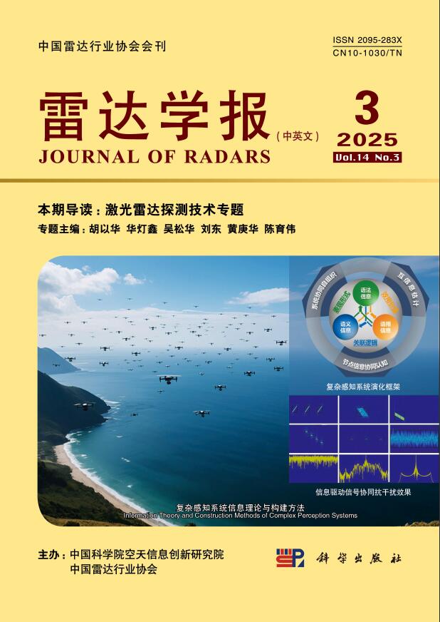
- Figure 1. Schematic diagram and prototype of HSL
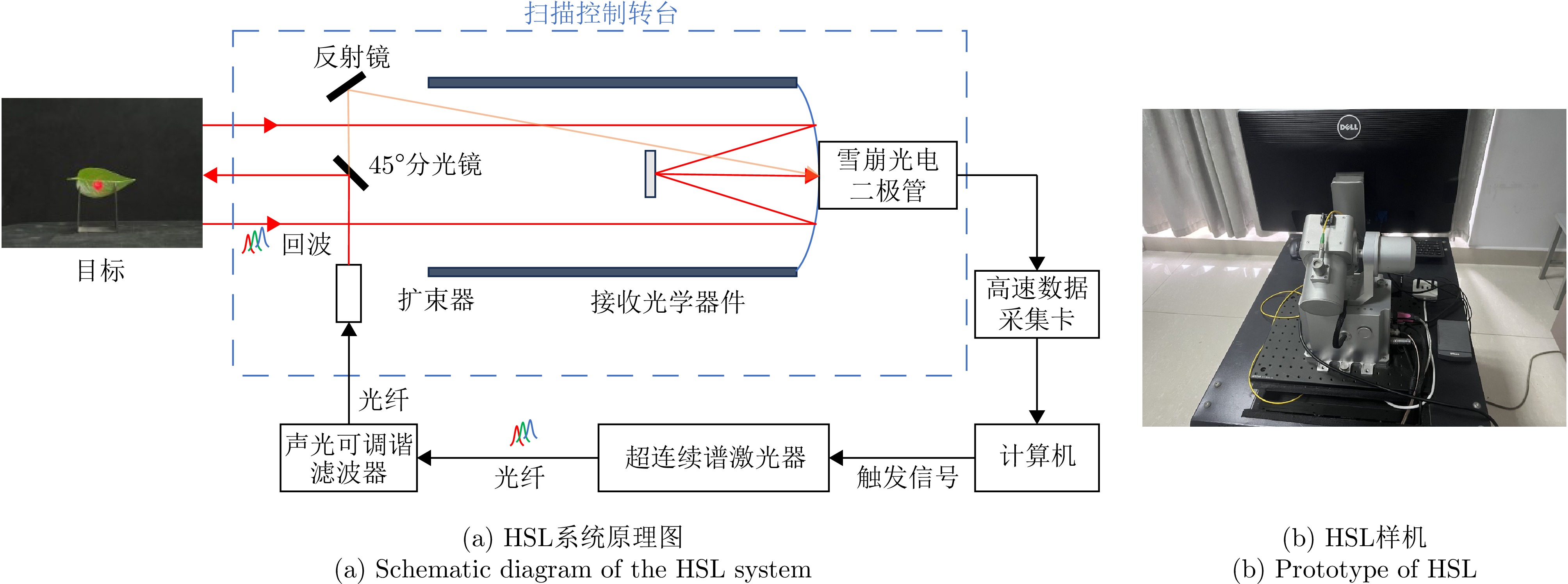
- Figure 2. Scanning trajectory diagram
- Figure 3. Full-waveform signal acquired at a single wavelength (750 nm)
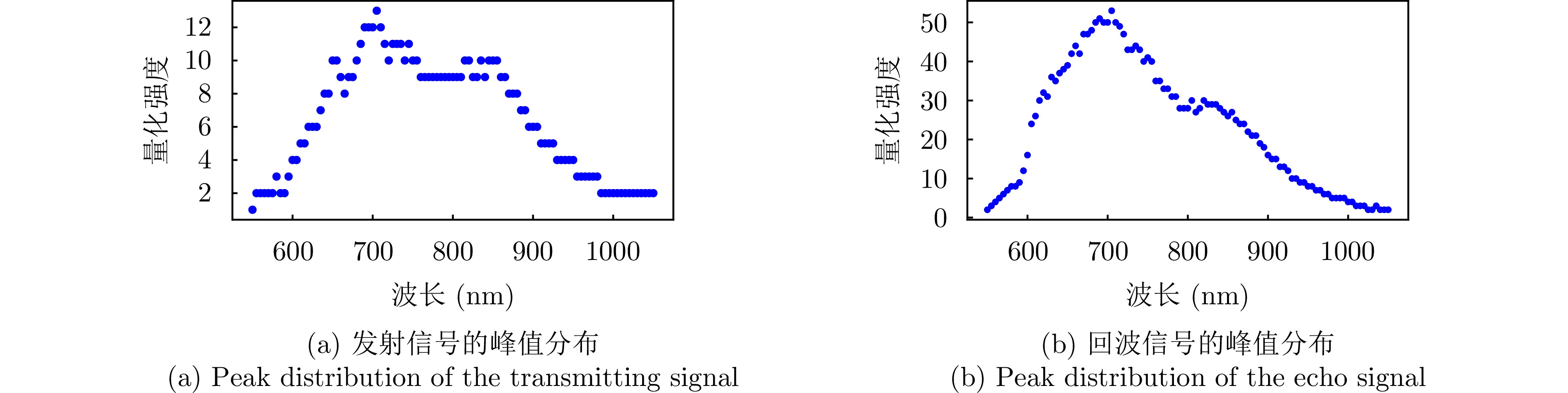
- Figure 4. Peak distributions of HSL transmitting and echo signal
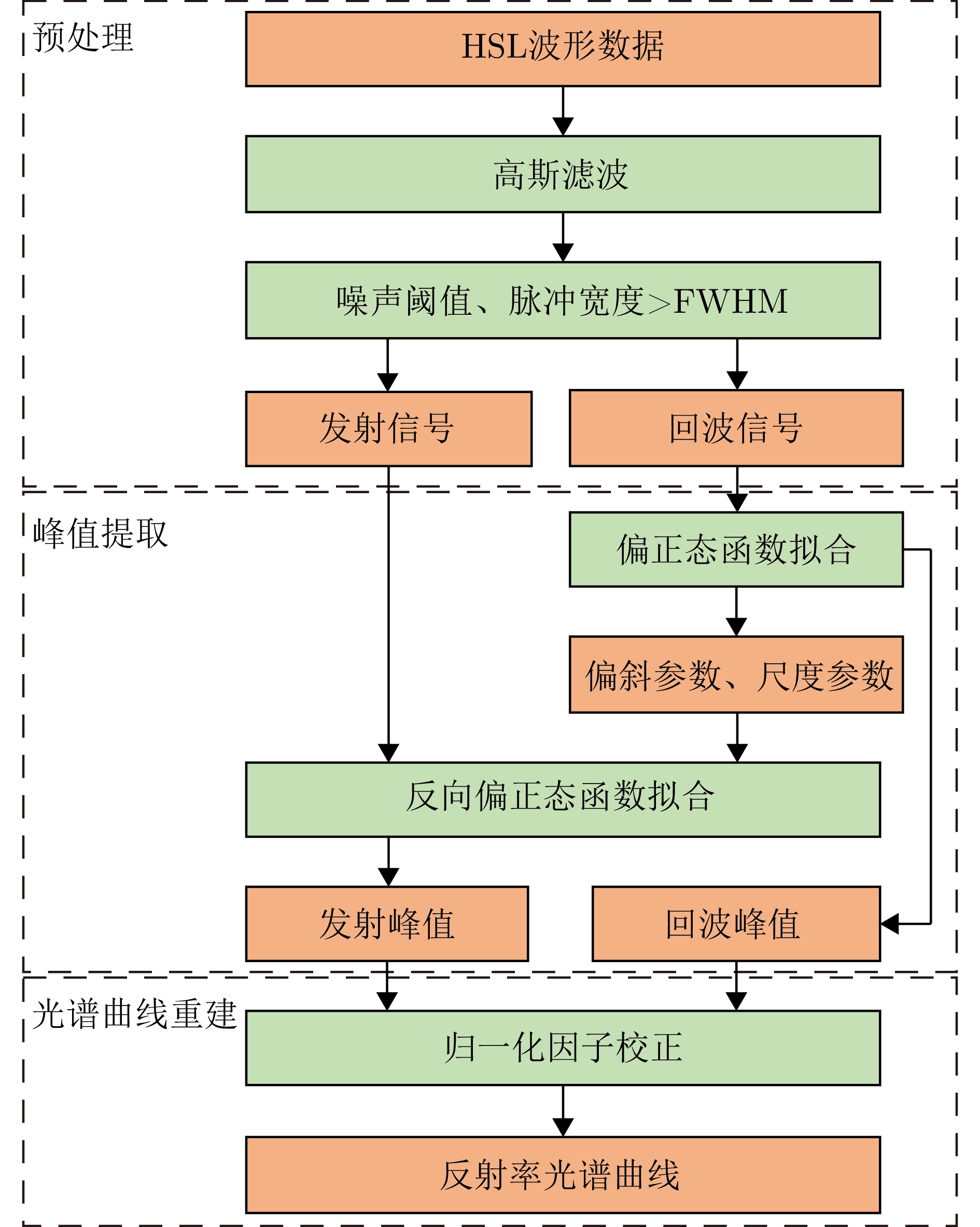
- Figure 5. Block diagram of the proposed method
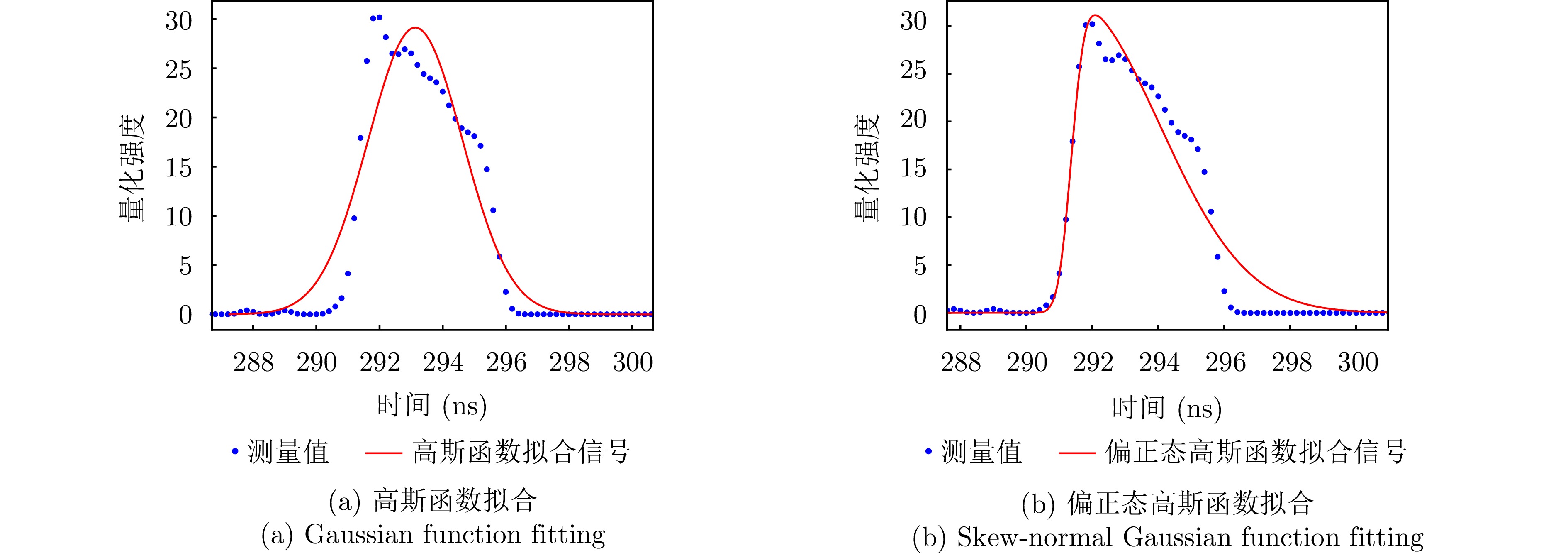
- Figure 6. Fitting of the echo signal of the standard diffuse whiteboard
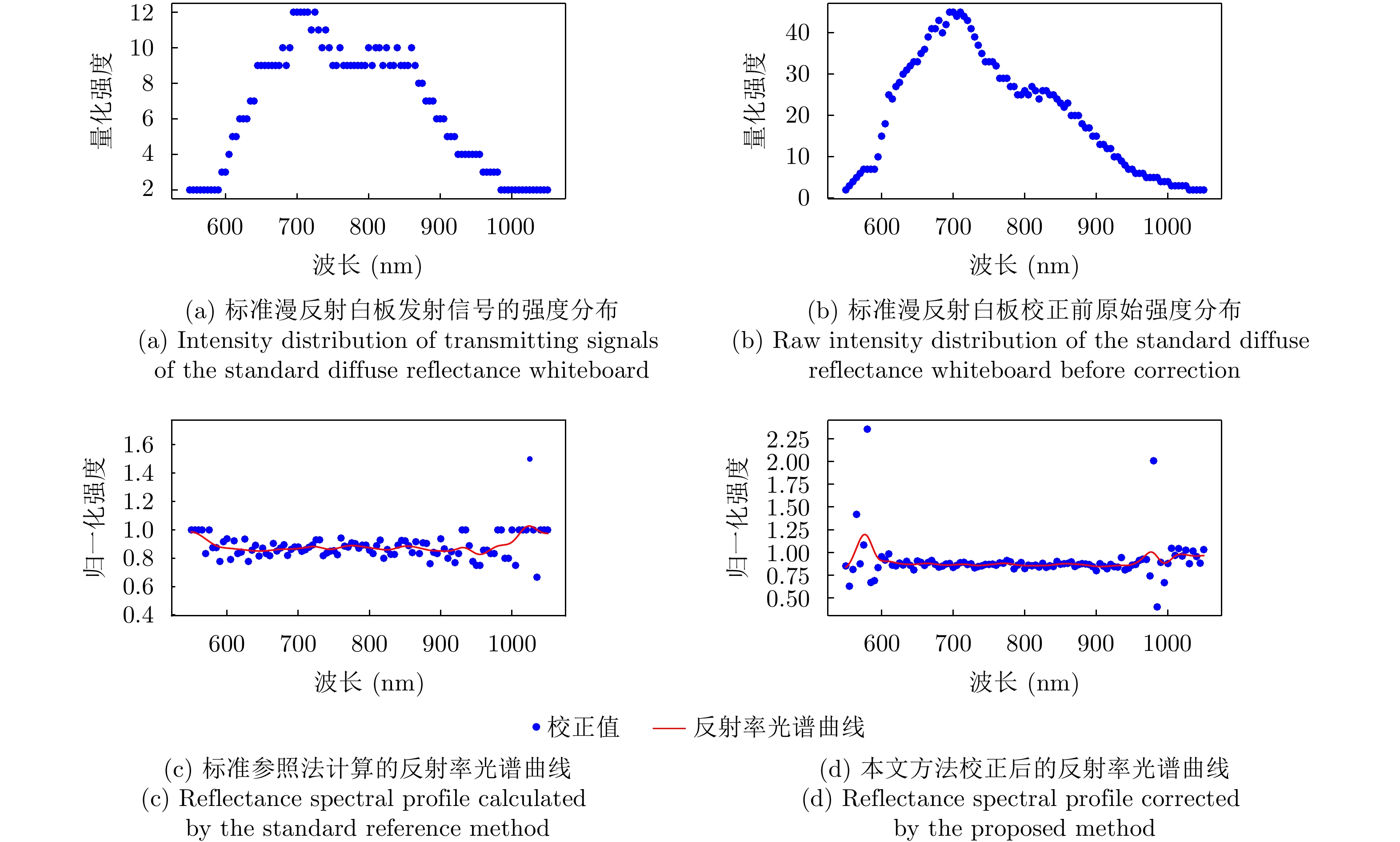
- Figure 7. The intensity distribution of the standard diffuse reflectance whiteboard transmitting and echo signals before correction by the proposed method, and the reflectance spectral profiles after correction
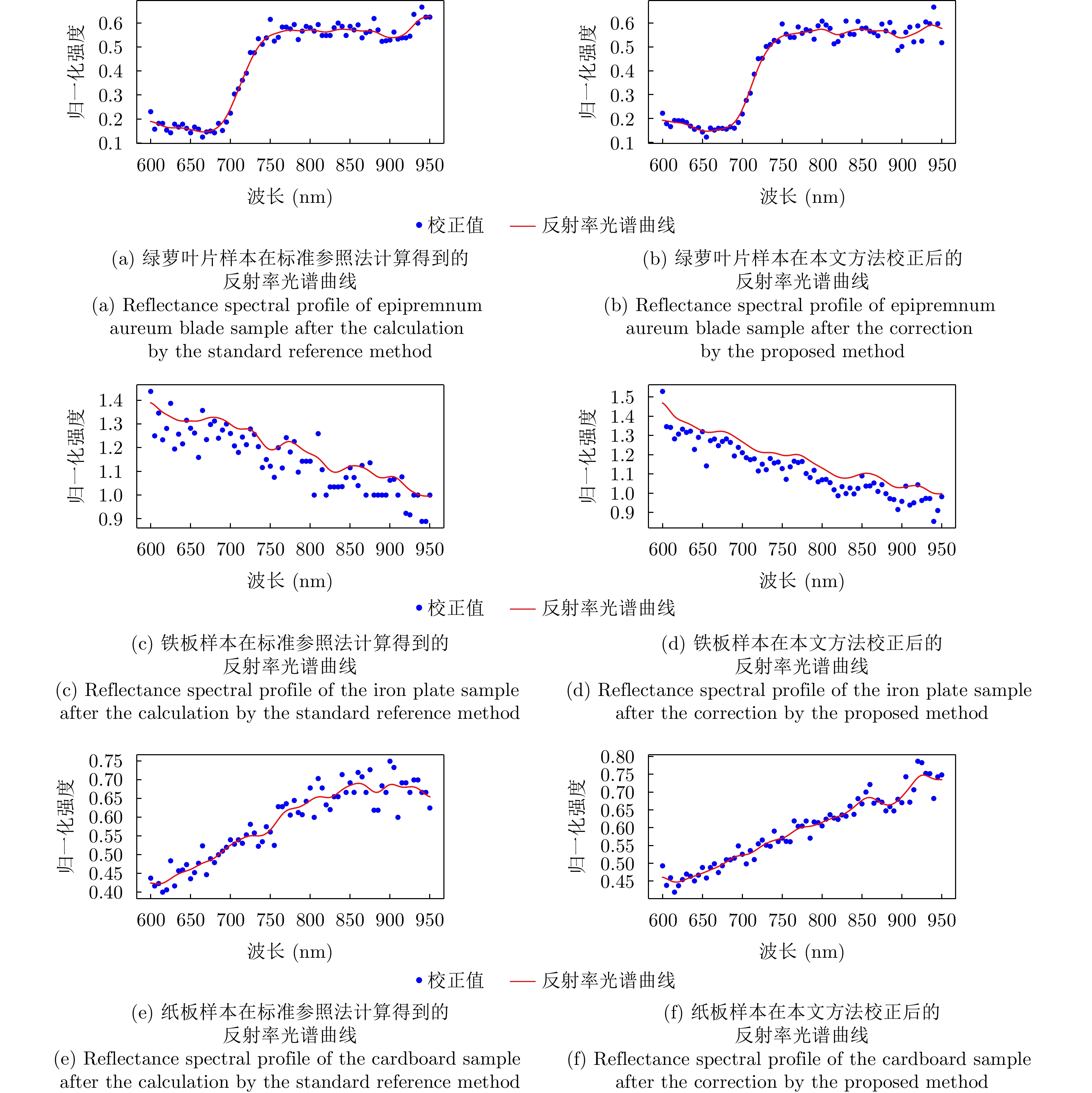
- Figure 8. Reflectance spectral profile of different samples after correction
- Figure 9. The intensity distribution of Pachira macrocarpa transmitting and echo signals before correction by the proposed method, and the reflectance spectral profile after correction
- Figure 10. Point cloud of Pachira macrocarpa before and after wood-leaf separation
- Figure 11. The raw point cloud of Citrus limon in the 700 nm
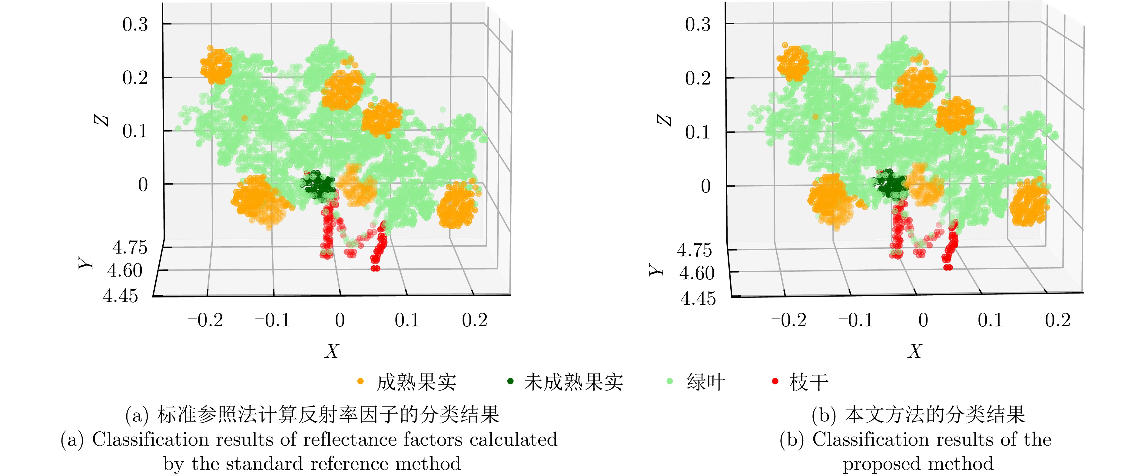
- Figure 12. Classification results with spectral profiles corrected by different methods