
 Submit Manuscript
 Peer Review
 Editor Work
- Home
- Articles & Issues
-
Data
- Dataset of Radar Detecting Sea
- SAR Dataset
- SARGroundObjectsTypes
- SARMV3D
- AIRSAT Constellation SAR Land Cover Classification Dataset
- 3DRIED
- UWB-HA4D
- LLS-LFMCWR
- FAIR-CSAR
- MSAR
- SDD-SAR
- FUSAR
- SpaceborneSAR3Dimaging
- Sea-land Segmentation
- SAR Multi-domain Ship Detection Dataset
- SAR-Airport
- Hilly and mountainous farmland time-series SAR and ground quadrat dataset
- SAR images for interference detection and suppression
- HP-SAR Evaluation & Analytical Dataset
- GDHuiYan-ATRNet
- Multi-System Maritime Low Observable Target Dataset
- DatasetinthePaper
- DatasetintheCompetition
- Report
- Course
- About
- Publish
- Editorial Board
- Chinese
| Citation: | LYU Zexin, QIU Xiaolan, ZHANG Zhe, et al. Error analysis of polarimetric interferometric SAR under different processing modes in urban areas[J]. Journal of Radars, 2022, 11(4): 600–617. doi: 10.12000/JR22059

|
Error Analysis of Polarimetric Interferometric SAR under Different Processing Modes in Urban Areas
DOI: 10.12000/JR22059 CSTR: 32380.14.JR22059
More Information-
Abstract
Polarimetric Interferometric Synthetic Aperture Radar (PolInSAR) simultaneously has interferometric height measurement and full-polarized detection capabilities, which can better reflect the structural properties of feature targets. Therefore, its potential for application in complex scenarios, such as urban areas, has attracted increasing attention. In urban areas, the processing mainly includes three modes: using interferometry to extract height based on polarimetric optimal coherence, using interferometry based on polarized decomposition, and associating polarimetric interferometric observation equations to retrieve the heights of different scattering mechanisms. The analysis of error factors and effects on Interferometric SAR (InSAR) and polarized SAR is almost complete, but the analysis of error effects under different processing modes of PolInSAR is insufficient. Based on the PolInSAR error model, our paper proposes a method for solving the scattering mechanism under the simultaneous polarization observation equation. Moreover, we derive the model including each error under different processing modes in PolInSAR from the aspect of polarized errors, interferometric errors, and the Signal-to-Noise Ratio (SNR). Furthermore, the model is verified through simulations, and we provide height inversion results through three processing modes after compensating for polarized errors and interferometric errors. After the error compensation, we obtain a Root Mean Squared Error (RMSE) in building areas of 2.77 m through polarimetric optimal coherence. Finally, the simulations provide the error impact curves under different processing modes of PolInSAR and compare the degree of different processing methods affected by errors, which provides a reasonable explanation for the design of the PolInSAR system, selection of processing methods, and data application. -

-
References
[1] CLOUDE S R and PAPATHANASSIOU K P. Polarimetric SAR interferometry[J]. IEEE Transactions on Geoscience and Remote Sensing, 1998, 36(5): 1551–1565. doi: 10.1109/36.718859[2] TREUHAFT R N and CLOUDE S R. The structure of oriented vegetation from polarimetric interferometry[J]. IEEE Transactions on Geoscience and Remote Sensing, 1999, 37(5): 2620–2624. doi: 10.1109/36.789657[3] CLOUDE S R and PAPATHANASSIOU K P. Three-stage inversion process for Polarimetric SAR interferometry[J]. IEE Proceedings-Radar, Sonar and Navigation, 2003, 150(3): 125–134. doi: 10.1049/ip-rsn:20030449[4] PAPATHANASSIOU K P and CLOUDE S R. Single-baseline Polarimetric SAR interferometry[J]. IEEE Transactions on Geoscience and Remote Sensing, 2001, 39(11): 2352–2363. doi: 10.1109/36.964971[5] GARESTIER F, DUBOIS-FERNANDEZ P, DUPUIS X, et al. PolInSAR analysis of X-band data over vegetated and urban areas[J]. IEEE Transactions on Geoscience and Remote Sensing, 2006, 44(2): 356–364. doi: 10.1109/TGRS.2005.862525[6] 王萍, 汪长城, 彭星, 等. 基于PolInSAR三分量分解的建筑物高度向信息提取方法[J]. 测绘工程, 2014, 23(6): 16–20, 26. doi: 10.3969/j.issn.1006-7949.2014.06.004WANG Ping, WANG Changcheng, PENG Xing, et al. Building height information extraction method based on three-component decomposition for PolInSAR data[J]. Engineering of Surveying and Mapping, 2014, 23(6): 16–20, 26. doi: 10.3969/j.issn.1006-7949.2014.06.004[7] GUILLASO S, FERRO-FAMIL L, REIGBER A, et al. Analysis of built-up areas from Polarimetric interferometric SAR images[C]. 2003 IEEE International Geoscience and Remote Sensing Symposium, Toulouse, France, 2003: 1727–1729.[8] COLIN E, TITIN-SCHNAIDER C, and TABBARA W. An interferometric coherence optimization method in radar polarimetry for high-resolution imagery[J]. IEEE Transactions on Geoscience and Remote Sensing, 2006, 44(1): 167–175. doi: 10.1109/TGRS.2005.859357[9] COLIN-KOENIGUER E and TROUVÉ N. Performance of building height estimation using high-resolution PolInSAR images[J]. IEEE Transactions on Geoscience and Remote Sensing, 2014, 52(9): 5870–5879. doi: 10.1109/TGRS.2013.2293605[10] CLOUDE S R. Calibration requirements for forest parameter estimation using POLinSAR[C]. CEOS Working Group on Calibration/Validation SAR Workshop, London, UK, 2002: 151–158.[11] 张林涛, 洪峻, 明峰. PolInSAR极化误差对最优相干相位的影响研究[J]. 电子与信息学报, 2011, 33(2): 412–417. doi: 10.3724/SP.J.1146.2010.00331ZHANG Lintao, HONG Jun, and MING Feng. Study on the impact of Polarimetric error on optimal coherence phase of PolInSAR[J]. Journal of Electronics &Information Technology, 2011, 33(2): 412–417. doi: 10.3724/SP.J.1146.2010.00331[12] 许丽颖. 极化干涉合成孔径雷达系统与信息处理技术研究[D]. [博士论文], 中国科学院电子学研究所, 2014: 127–136.XU Liying. Study on system and information processing of Polarimetric SAR interferometry[D]. [Ph. D. dissertation], Institute of Electronics, Chinese Academy of Sciences, 2014: 127–136.[13] 孙翔. 极化干涉合成孔径雷达地物参数估计与系统设计方法研究[D]. [博士论文], 中国科学院电子学研究所, 2018: 110–113.SUN Xiang. On approach of estimating ground feature parameters and system design of Polarimetric SAR interferometry[D]. [Ph. D. dissertation], Institute of Electronics, Chinese Academy of Sciences, 2018: 110–113.[14] SUN Zhongchang, GUO Huadong, LI Xinwu, et al. Error analysis of DEM derived from airborne single-pass interferometric SAR data[C]. 2011 IEEE International Geoscience and Remote Sensing Symposium, Vancouver, Canada, 2011: 3405–3408.[15] ZHAO Shuyuan, GU Defeng, YI Bin, et al. Error analysis for the baseline estimation and calibration of distributed InSAR satellites[C]. 2016 IEEE International Geoscience and Remote Sensing Symposium, Beijing, China, 2016: 4179–4182.[16] 生强强. InSAR DEM精度分析与定量评估方法[D]. [硕士论文], 西安电子科技大学, 2018.SHENG Qiangqiang. InSAR DEM accuracy analysis and quantitative evaluation[D]. [Master dissertation], Xidian University, 2018.[17] 方东生, 吕孝雷, 李缘廷, 等. 运动补偿对机载SAR重轨干涉成像的影响分析[J]. 雷达科学与技术, 2016, 14(4): 355–363. doi: 10.3969/j.issn.1672-2337.2016.04.003FANG Dongsheng, LV Xiaolei, LI Yuanting, et al. Effect of motion compensation on airborne repeat pass InSAR imaging[J]. Radar Science and Technology, 2016, 14(4): 355–363. doi: 10.3969/j.issn.1672-2337.2016.04.003[18] WANG Huiqiang, ZHU Jianjun, FU Haiqiang, et al. Modeling and robust estimation for the residual motion error in airborne SAR interferometry[J]. IEEE Geoscience and Remote Sensing Letters, 2019, 16(1): 65–69. doi: 10.1109/LGRS.2018.2867868[19] 孙晗伟, 曾涛, 杨健, 等. SAR残余相位误差对森林高度反演影响的全链路模拟与分析[J]. 武汉大学学报: 信息科学版, 2015, 40(2): 153–158. doi: 10.13203/j.whugis20130052SUN Hanwei, ZENG Tao, YANG Jian, et al. Simulation and analysis of SAR residual phase error on forest height inversion[J]. Geomatics and Information Science of Wuhan University, 2015, 40(2): 153–158. doi: 10.13203/j.whugis20130052[20] LV Zexin, LI Fangfang, QIU xiaolan, et al. Effects of motion compensation residual error and polarization distortion on UAV-borne PolInSAR[J]. Remote Sensing, 2021, 13(4): 618. doi: 10.3390/rs13040618[21] ROY R and KAILATH T. ESPRIT-estimation of signal parameters via rotational invariance techniques[J]. IEEE Transactions on Acoustics, Speech, and Signal Processing, 1989, 37(7): 984–995. doi: 10.1109/29.32276[22] LV Zexin, QIU Xiaolan, CHENG Yao, et al. Multi-rotor UAV-borne PolInSAR data processing and preliminary analysis of height inversion in urban area[J]. Remote Sensing, 2022, 14(9): 2161. doi: 10.3390/rs14092161 -
Proportional views

- Publishing Ethics
- Journal Insights
- Abstracting & Indexing
- Peer Review Policies
- Guide for Authors
- Conference
- ISSN 2095-283X (Print)ISSN 2097-339X (Online)
- CN 10-1030/TN
- CODEN LXEUAO
About Journal
- Sponsor: China Radio Detection and Ranging Industry Association (CRIA)
- Phone: 010-58887062
- Email:radars@aircas.ac.cn
- Publisher: Leida Xuebao Bianjibu (Editorial office of the Journal of Radars)
Contacts Us

京ICP备20021838号-14
Supported by: Beijing Renhe Information Technology Co. Ltd

Export File
Citation
Format
Content
 DownLoad:


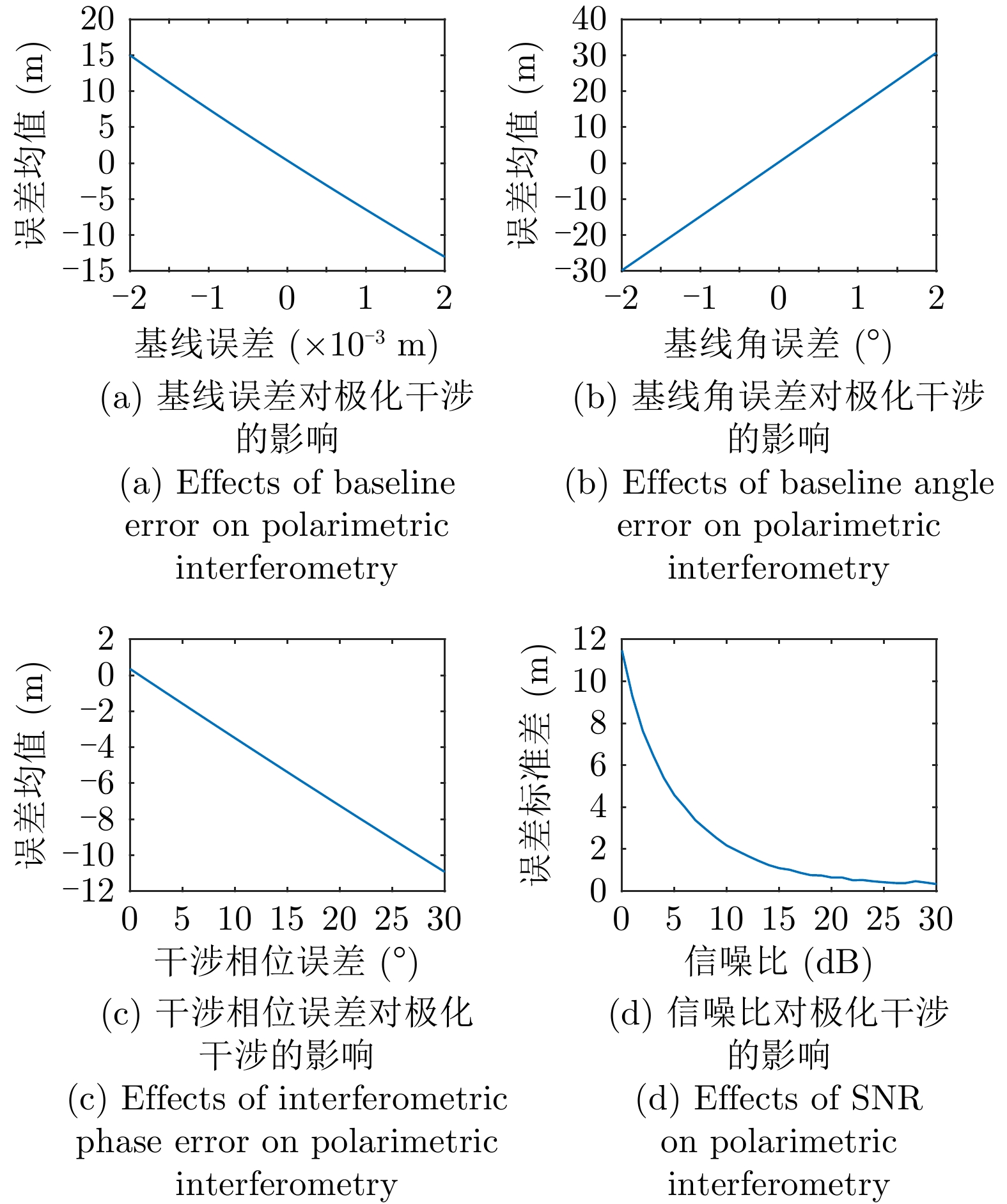


- Figure 1. The schematic diagram of InSAR
- Figure 2. Simulation image
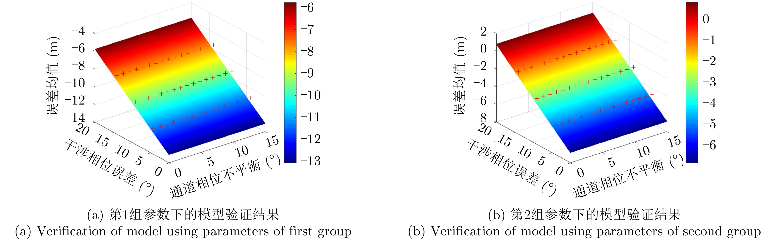
- Figure 3. Verification of PolInSAR error model
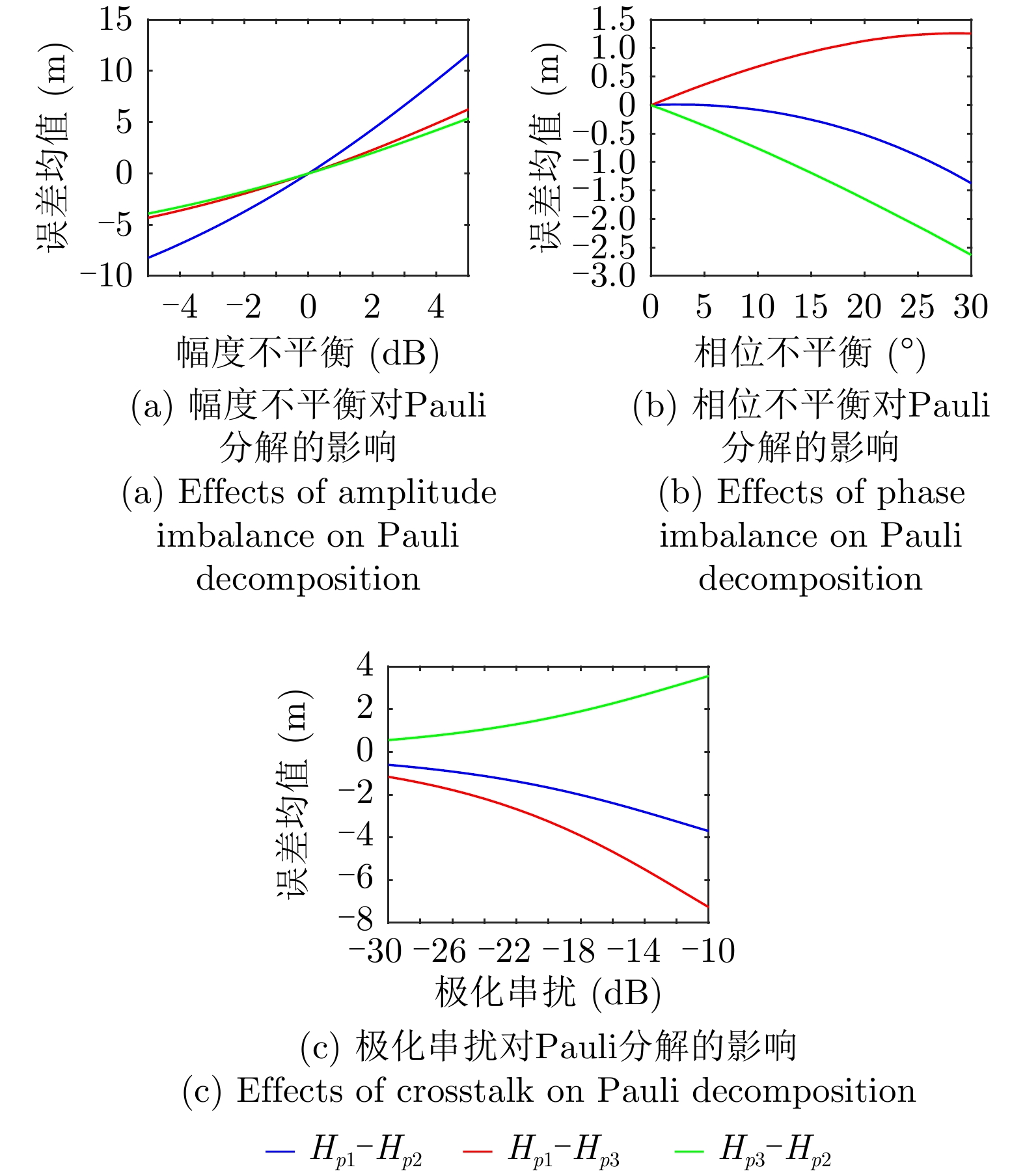
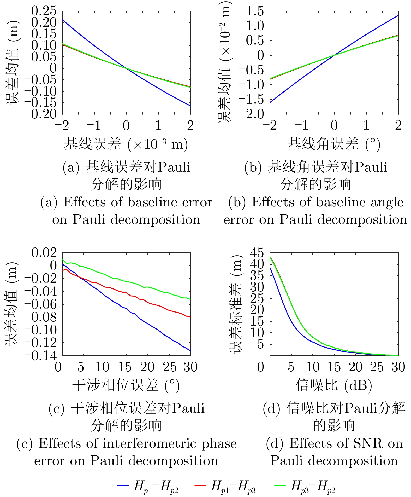
- Figure 4. Verification of error model under Pauli decomposition (Single height)
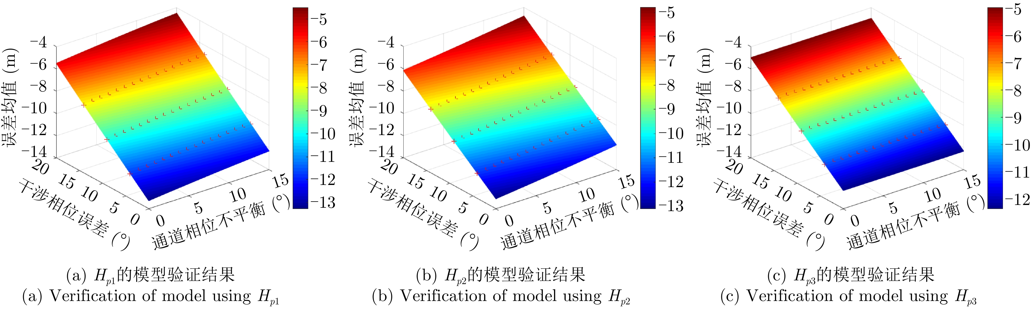
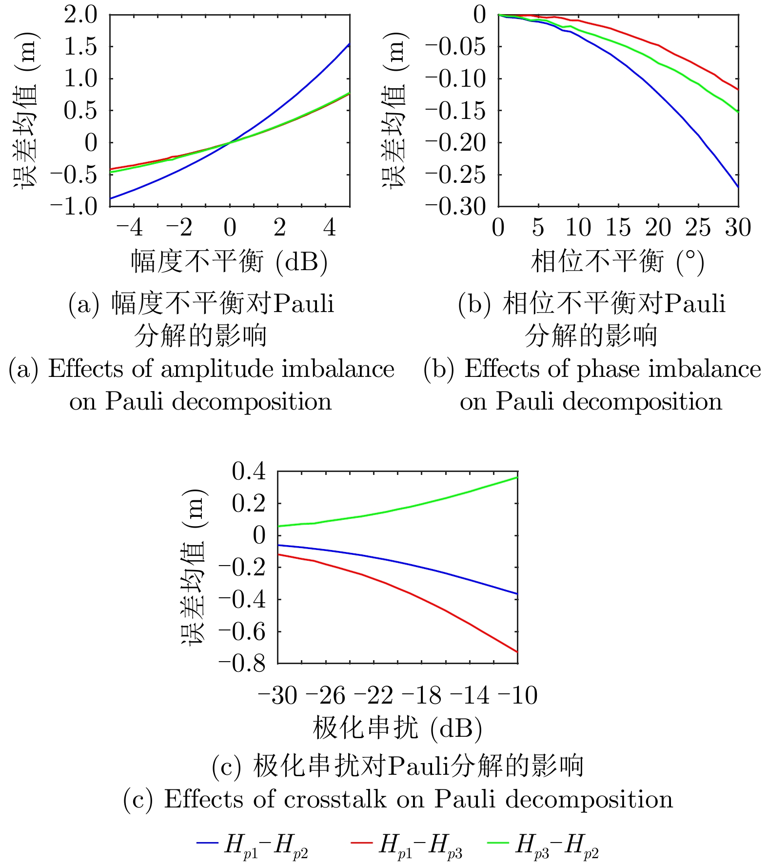
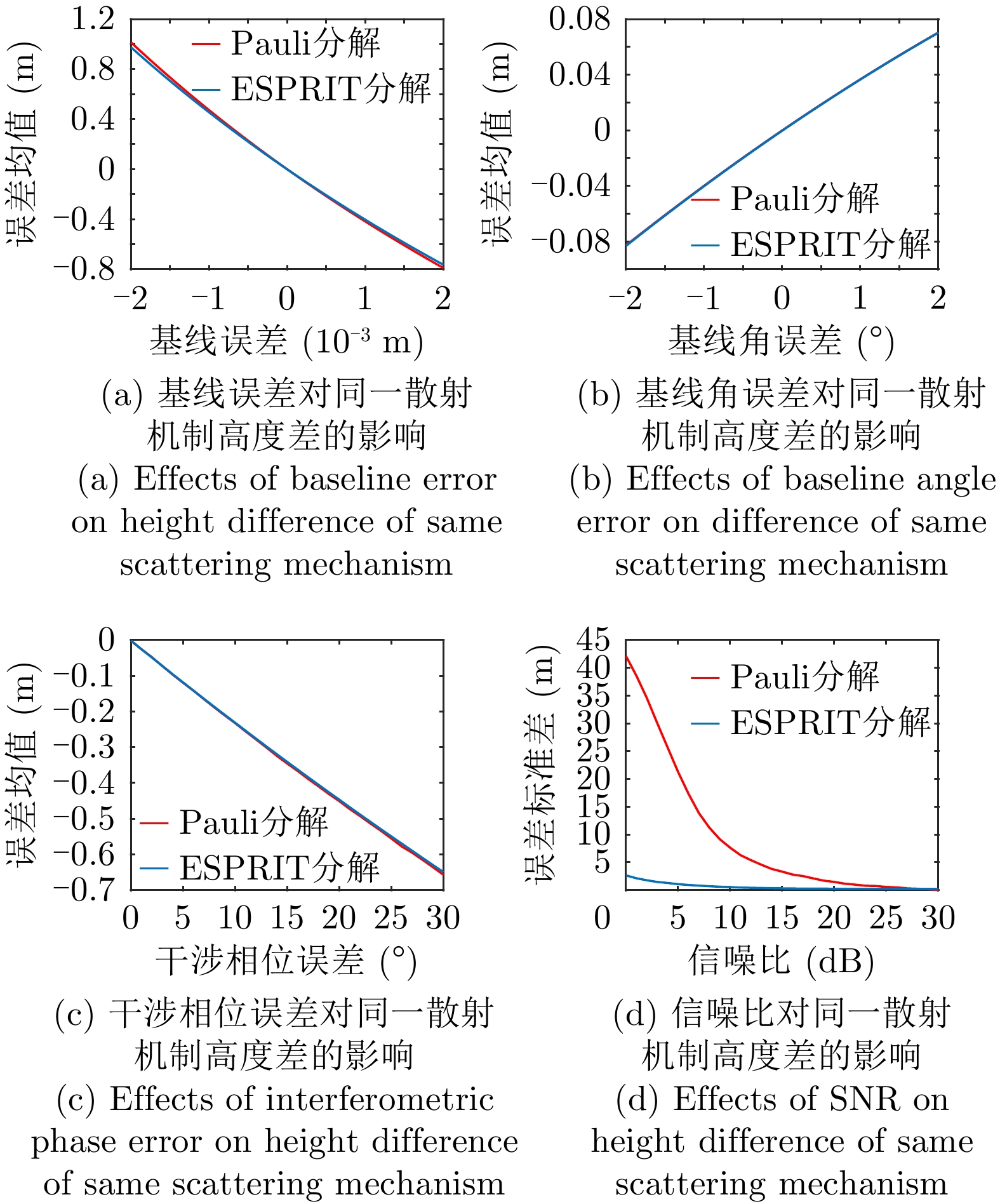
- Figure 5. Verification of error model under Pauli decomposition (Height difference)
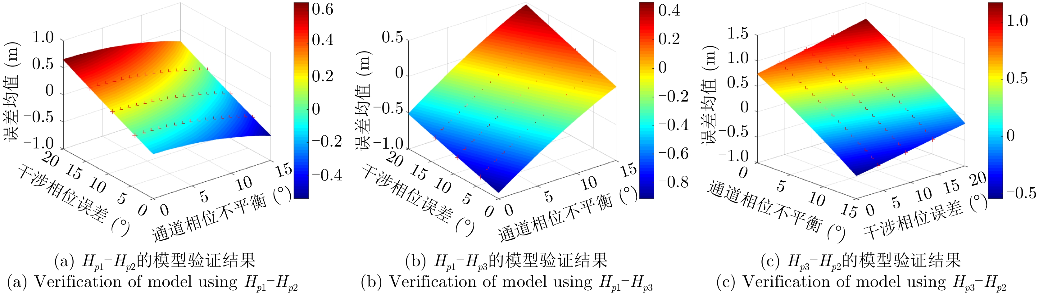
- Figure 6. Verification of error model of PolInSAR combined with ESPRIT (Single Height)
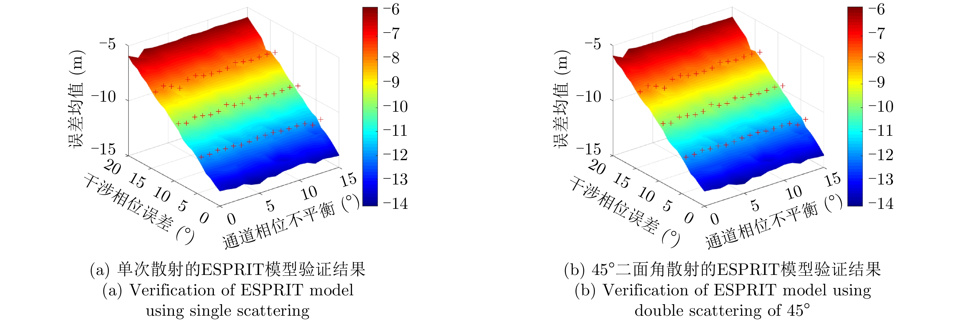
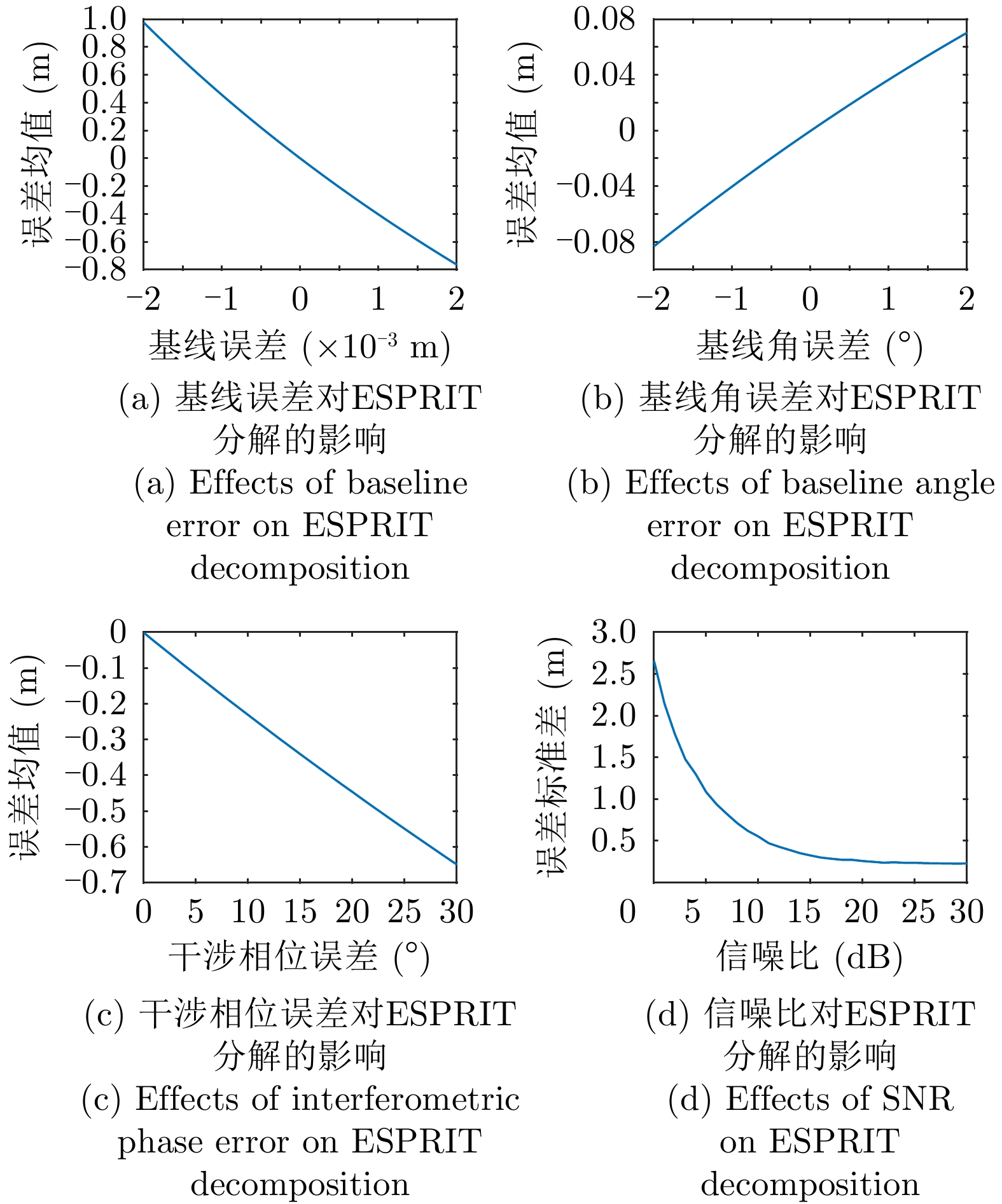
- Figure 7. Verification of error model of PolInSAR combined with ESPRIT
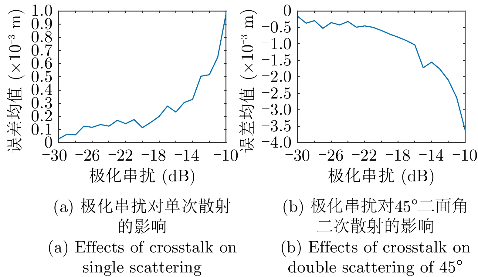
- Figure 8. Effects of crosstalk on height obtained by ESPRIT decomposition
- Figure 9. Effects of polarization distortion on ESPRIT error model when distortion is equal on two antennas
- Figure 10. Effects of polarization distortion on height obtained by PolInSAR
- Figure 11. Effects of interferometric error on height obtained by PolInSAR
- Figure 12. Effects of polarization distortion on height obtained by Pauli decomposition
- Figure 13. Effects of interferometric error on height obtained by PolInSAR
- Figure 14. Effects of polarization distortion on Pauli decomposition
- Figure 15. Effects of interferometric error on Pauli decomposition
- Figure 16. Effects of polarization distortion on ESPRIT
- Figure 17. Effects of interferometric error on ESPRIT
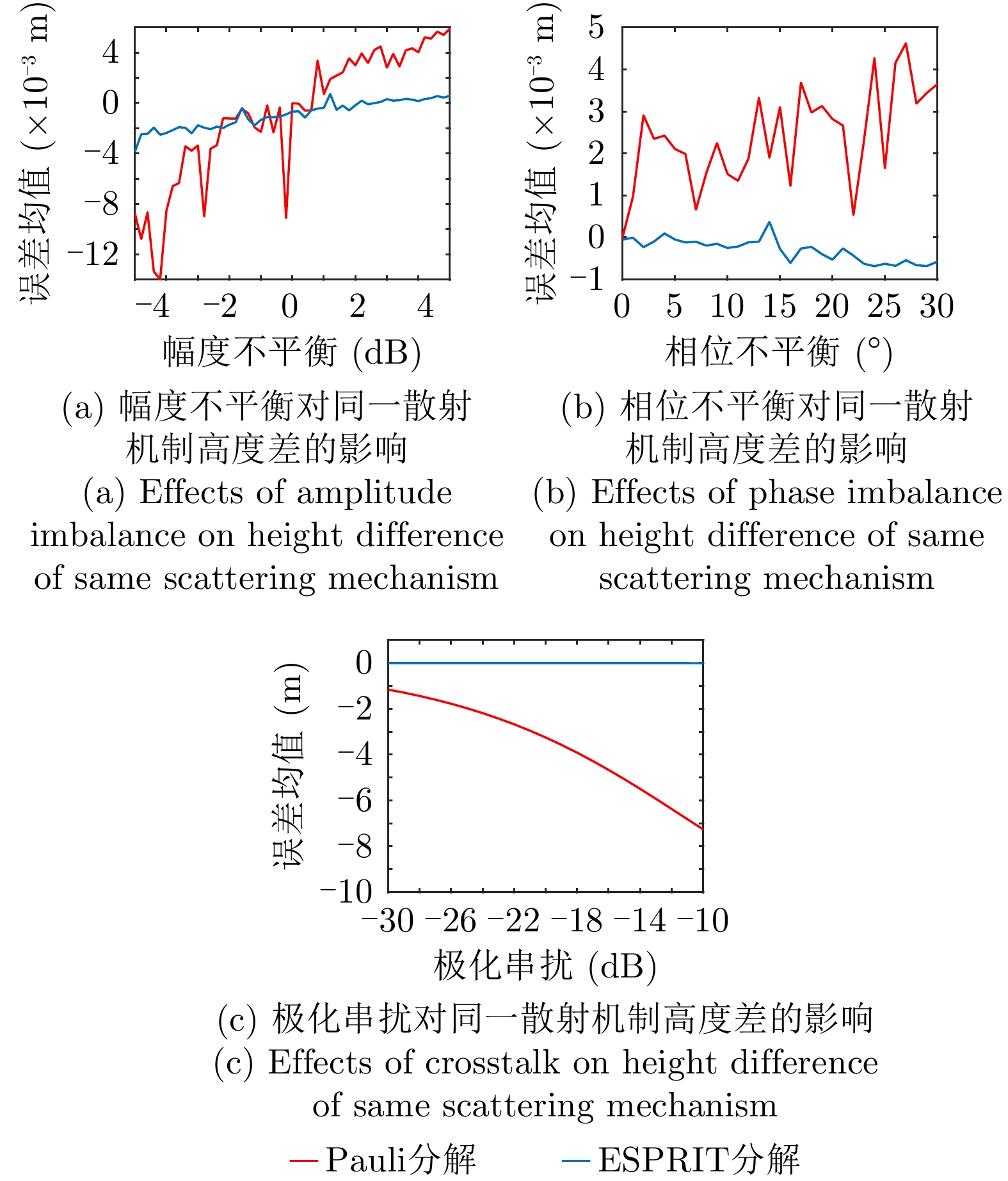
- Figure 18. Effects of polarization distortion on height difference of scattering mechanisms
- Figure 19. Effects of interferometric error on height difference of scattering mechanisms
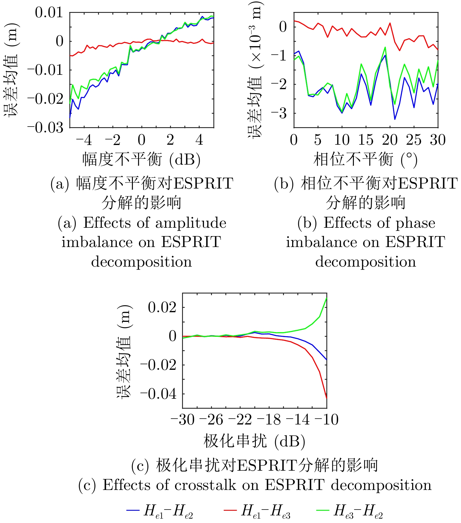
- Figure 20. Effects of polarization distortion on ESPRIT mixed by 3 mechanisms
- Figure 21. Effects of interferometric error on ESPRIT mixed by 3 mechanisms
- Figure 22. UAV-borne PolInSAR system
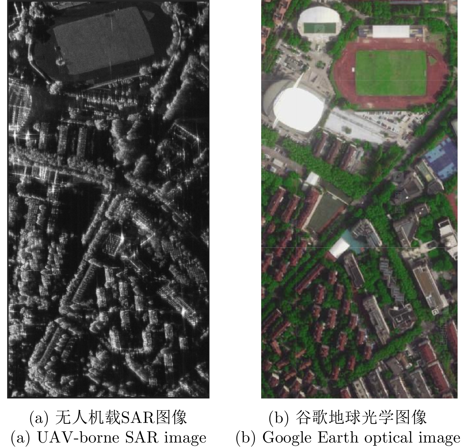
- Figure 23. Imaging area of UAV-borne system
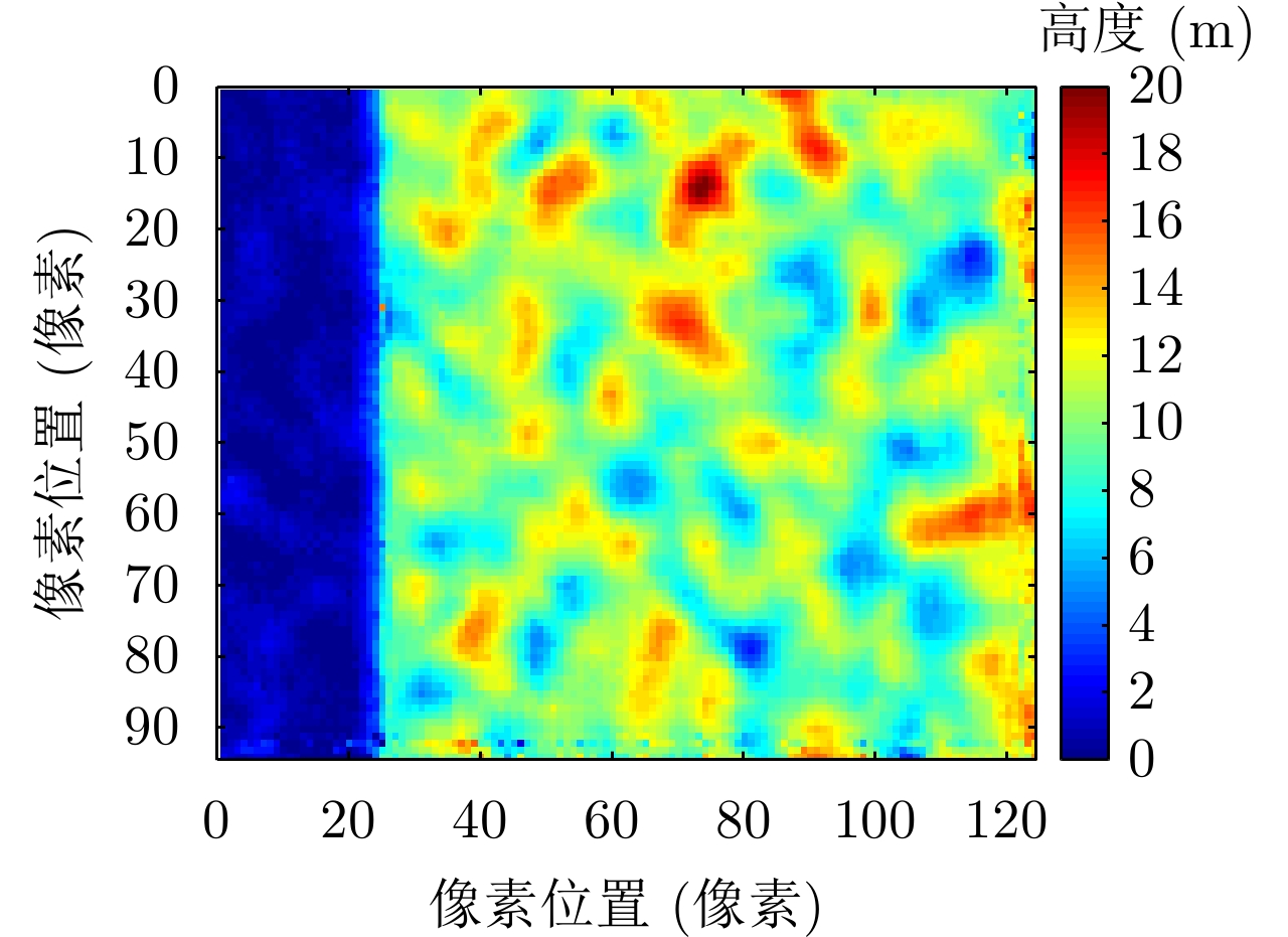
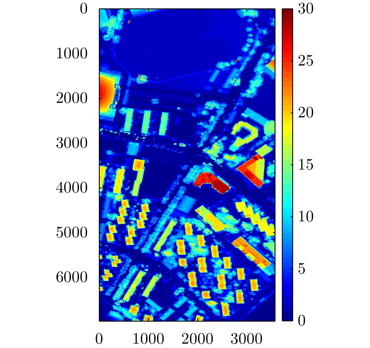
- Figure 24. Real height
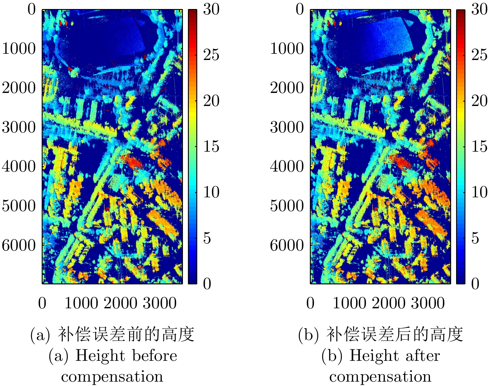
- Figure 25. Height retrieved by polarimetric optimal coherence
- Figure 26. Height retrieved by single scattering
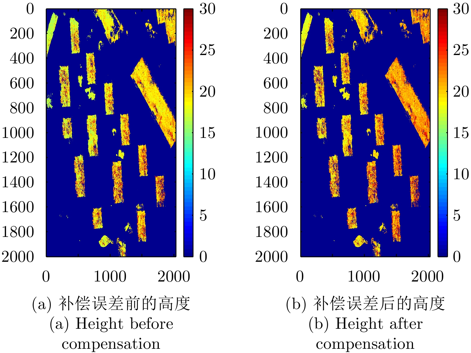
- Figure 27. Height retrieved by ESPRIT