
 Submit Manuscript
 Peer Review
 Editor Work
- Home
- Articles & Issues
-
Data
- Dataset of Radar Detecting Sea
- SAR Dataset
- SARGroundObjectsTypes
- SARMV3D
- AIRSAT Constellation SAR Land Cover Classification Dataset
- 3DRIED
- UWB-HA4D
- LLS-LFMCWR
- FAIR-CSAR
- MSAR
- SDD-SAR
- FUSAR
- SpaceborneSAR3Dimaging
- Sea-land Segmentation
- SAR Multi-domain Ship Detection Dataset
- SAR-Airport
- Hilly and mountainous farmland time-series SAR and ground quadrat dataset
- SAR images for interference detection and suppression
- HP-SAR Evaluation & Analytical Dataset
- GDHuiYan-ATRNet
- Multi-System Maritime Low Observable Target Dataset
- DatasetinthePaper
- DatasetintheCompetition
- Report
- Course
- About
- Publish
- Editorial Board
- Chinese

| Citation: | Wang Song, Zhang Fubo, Chen Longyong, Liang Xingdong. Array-interferometric Synthetic Aperture Radar Point Cloud Filtering Based on Spatial Clustering Seed Growth Algorithm[J]. Journal of Radars, 2018, 7(3): 355-363. doi: 10.12000/JR18006

|
Array-interferometric Synthetic Aperture Radar Point Cloud Filtering Based on Spatial Clustering Seed Growth Algorithm
DOI: 10.12000/JR18006 CSTR: 32380.14.JR18006
-
Abstract
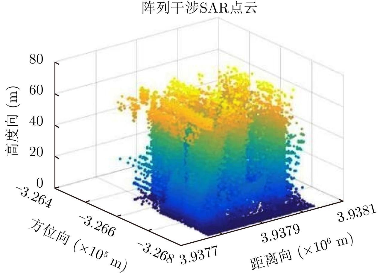
By arranging multiple antennas in the intersection direction and combining the synthetic aperture of azimuth direction and large bandwidth signal with oblique distance, array-interferometric Synthetic Aperture Radar (SAR) can generate a three-dimensional resolution and ensure the elevation spacial sampling due to its multiple array element, which could avoid the layover problem in surveying and mapping in the Interference SAR (InSAR) and realize the three-dimensional imaging of the observation scene. However, considering the existence of too much noise in the three-dimensional point cloud distribution in the scene area and the large elevation error, the traditional Light Detection And Ranging (LiDAR) point cloud filtering method is not suitable for the filtering processing of the array-interferometric SAR point cloud. In order to solve this problem, an array-interferometric SAR point cloud filtering algorithm based on spatial clustering seed growth algorithm is proposed, in which the density-elevation image is generated by the double threshold of density and elevation, the small clutter is removed by image processing, and the vegetation is removed from the point cloud data by using the spatial clustering seed growth algorithm, thus the point cloud filtering process is completed. Using the first airborne array-interferometric SAR experimental data, the validity of the proposed algorithm is verified compared to the traditional LiDAR filtering method, which provides the guarantee for the subsequent building extraction and meticulous treatment. -

-
References
[1] Cumming I G and Wong F H著. 洪文, 胡东辉, 译. 合成孔径雷达成像-算法与实现[M]. 北京: 电子工业出版社, 2007: 3–5.Cumming I G and Wong F H. Hong Wen and Hu Dong-hui, Trans. Digital Processing of Synthetic Aperture Radar Data: Algorithms and Implementation[M]. Beijing: Publishing House of Electronics Industry, 2007: 3–5.[2] Dorninger P and Pfeifer N. A comprehensive automated 3D approach for building extraction, reconstruction, and regularization from airborne laser scanning point clouds[J]. Sensors, 2008, 8(11): 7323–7343. DOI: 10.3390/s8117323[3] Filin S. Surface clustering from airborne laser scanning data[J]. International Archives of Photogrammetry and Remote Sensing, 2002, 32(3A): 119–124.[4] Elaksher A F and Bethel J S. Reconstructing 3D buildings from Lidar data[C]. Proceedings of the ISPRS Commission III Symposium on Photogrammetric Computer Vision, Graz, Austria, 2002: 1–6.[5] Forlani G, Nardinocchi C, Scaioni M, et al. Complete classification of raw LIDAR data and 3D reconstruction of buildings[J]. Pattern Analysis and Applications, 2006, 8(4): 357–374. DOI: 10.1007/s10044-005-0018-2[6] Zhu X X and Shahzad M. Facade reconstruction using Multiview Spaceborne TomoSAR point clouds[J]. IEEE Transactions on Geoscience and Remote Sensing, 2014, 52(6): 3541–3552. DOI: 10.1109/TGRS.2013.2273619[7] Shahzad M and Zhu X X. Reconstructing 2-D/3-D building shapes from spaceborne Tomographic Synthetic Aperture Radar data[C]. The International Archives of the Photogrammetry, Remote Sensing and Spatial Information Sciences, Volume XL-3, 2014, ISPRS Technical Commission III Symposium, Zurich, Switzerland, 2014.[8] Shahzad M and Zhu X X. Automatic detection and reconstruction of 2-D/3-D building shapes from Spaceborne TomoSAR point clouds[J]. IEEE Transactions on Geoscience and Remote Sensing, 2016, 54(3): 1292–1310. DOI: 10.1109/TGRS.2015.2477429[9] Sithole G and Vosselman G. Experimental comparison of filter algorithms for bare-earth extraction from airborne laser scanning point clouds[J]. ISPRS Journal of Photogrammetry and Remote Sensing, 2004, 59(1/2): 85–101. DOI: 10.1016/j.isprsjprs.2004.05.004[10] Vosselman G. Slope based filtering of laser altimetry data[J]. International Archives of Photogrammetry and Remote Sensing, 2000, 33(B3/2): 935–942.[11] 黄先锋, 李卉, 王潇, 等. 机载LiDAR数据滤波方法评述[J]. 测绘学报, 2009, 38(5): 466–469Huang Xian-feng, Li Hui, Wang Xiao, et al. Filter algorithms of airborne LiDAR data: Review and prospects[J]. Acta Geodaetica et Cartographica Sinica, 2009, 38(5): 466–469[12] Zhu X X and Bamler R. Super-resolution power and robustness of compressive sensing for spectral estimation with application to spaceborne tomographic SAR[J]. IEEE Transactions on Geoscience and Remote Sensing, 2012, 50(1): 247–258. DOI: 10.1109/TGRS.2011.2160183[13] Lombardini F. Differential tomography: A new framework for SAR interferometry[J]. IEEE Transactions on Geoscience and Remote Sensing, 2005, 43(1): 37–44. DOI: 10.1109/TGRS.2004.838371[14] Shahzad M and Zhu X X. Robust reconstruction of building facades for large areas using spaceborne TomoSAR point clouds[J]. IEEE Transactions on Geoscience and Remote Sensing, 2015, 53(2): 752–769. DOI: 10.1109/TGRS.2014.2327391[15] 栾晓岩. 一种TIN生成算法及其三维显示[J]. 海洋测绘, 2004, 24(5): 39–41. DOI: 10.3969/j.issn.1671-3044.2004.05.012Luan Xiao-yan. The method of building TIN and its three-dimensional display[J]. Hydrographic Surveying and Charting, 2004, 24(5): 39–41. DOI: 10.3969/j.issn.1671-3044.2004.05.012[16] 李杭, 梁兴东, 张福博, 等. 基于高斯混合聚类的阵列干涉SAR三维成像[J]. 雷达学报, 2017, 6(6): 630–639. DOI: 10.12000/JR17020Li Hang, Liang Xing-dong, Zhang Fu-bo, et al. 3D imaging for array InSAR based on Gaussian mixture model clustering[J]. Journal of Radars, 2017, 6(6): 630–639. DOI: 10.12000/JR17020 -
Proportional views

- Publishing Ethics
- Journal Insights
- Abstracting & Indexing
- Peer Review Policies
- Guide for Authors
- Conference
- ISSN 2095-283X (Print)ISSN 2097-339X (Online)
- CN 10-1030/TN
- CODEN LXEUAO
About Journal
- Sponsor: China Radio Detection and Ranging Industry Association (CRIA)
- Phone: 010-58887062
- Email:radars@aircas.ac.cn
- Publisher: Leida Xuebao Bianjibu (Editorial office of the Journal of Radars)
Contacts Us

京ICP备20021838号-14
Supported by: Beijing Renhe Information Technology Co. Ltd

Export File
Citation
Format
Content
 DownLoad:


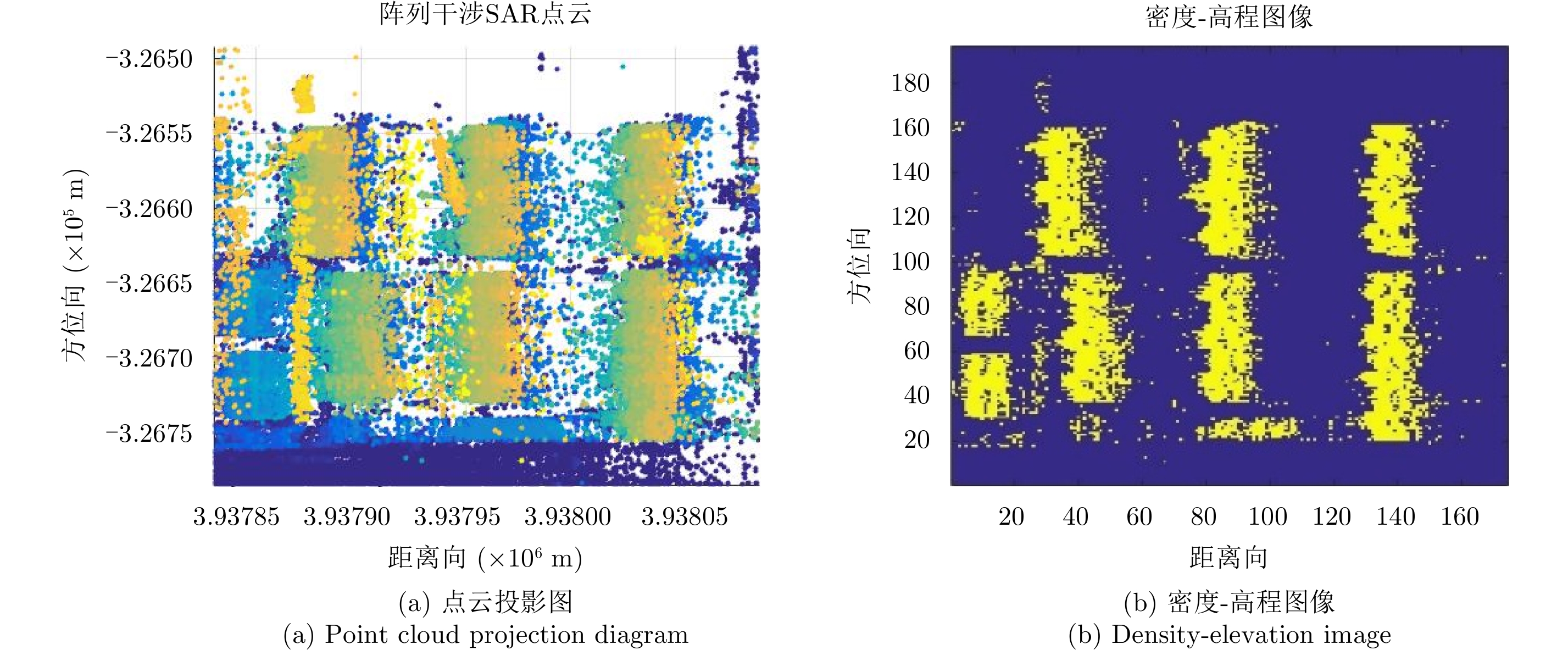
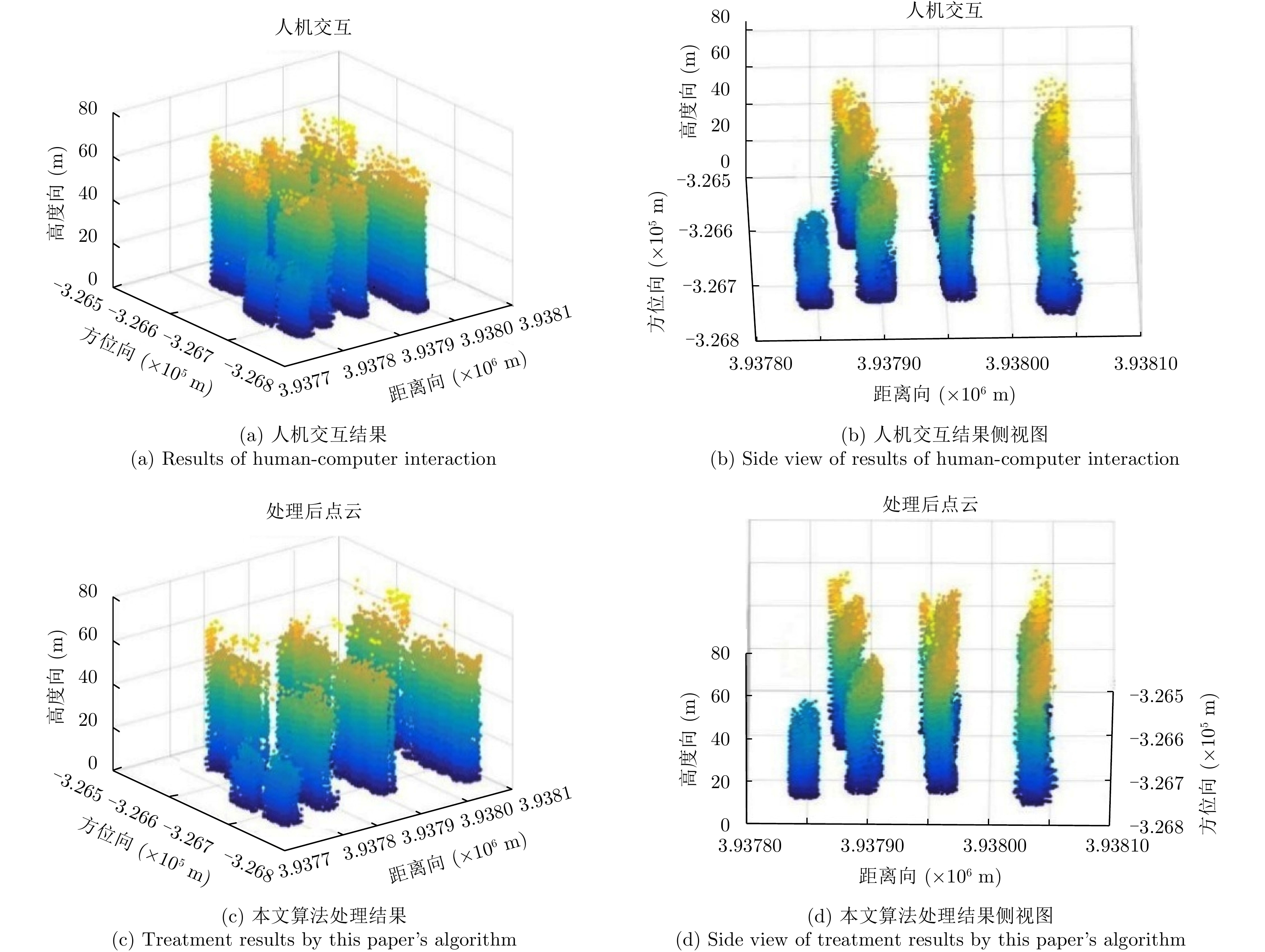
- Figure 1. The original three-dimensional point cloud
- Figure 2. Simple building model
- Figure 3. The encoding of the neighborhood in the search
- Figure 4. Flowchart of seed growth
- Figure 5. Schematic diagram before and after cloud processing
- Figure 6. Local enlarged image after processing
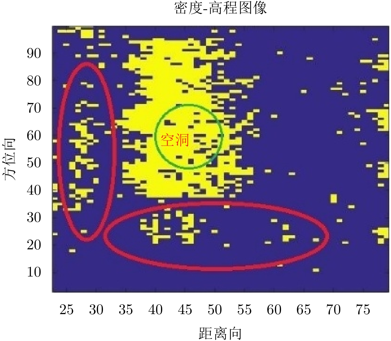
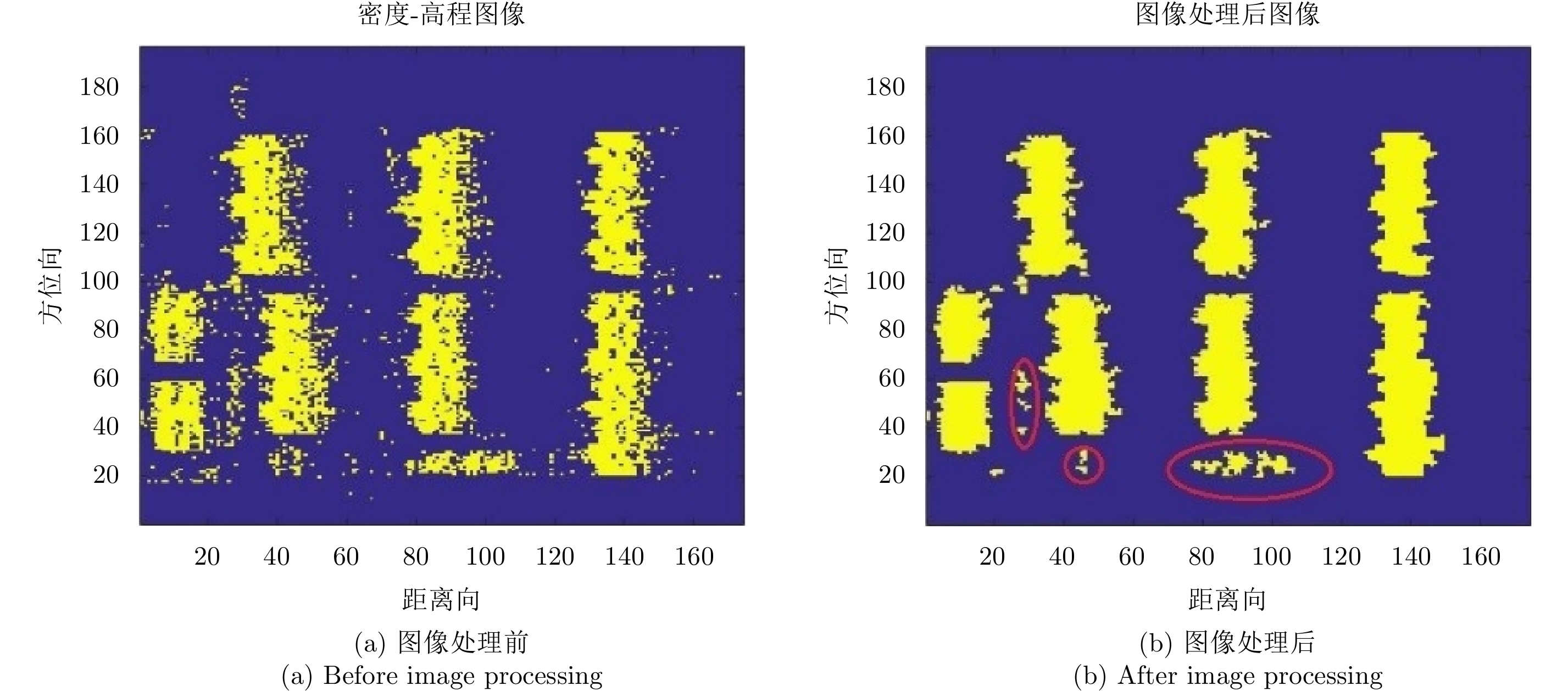
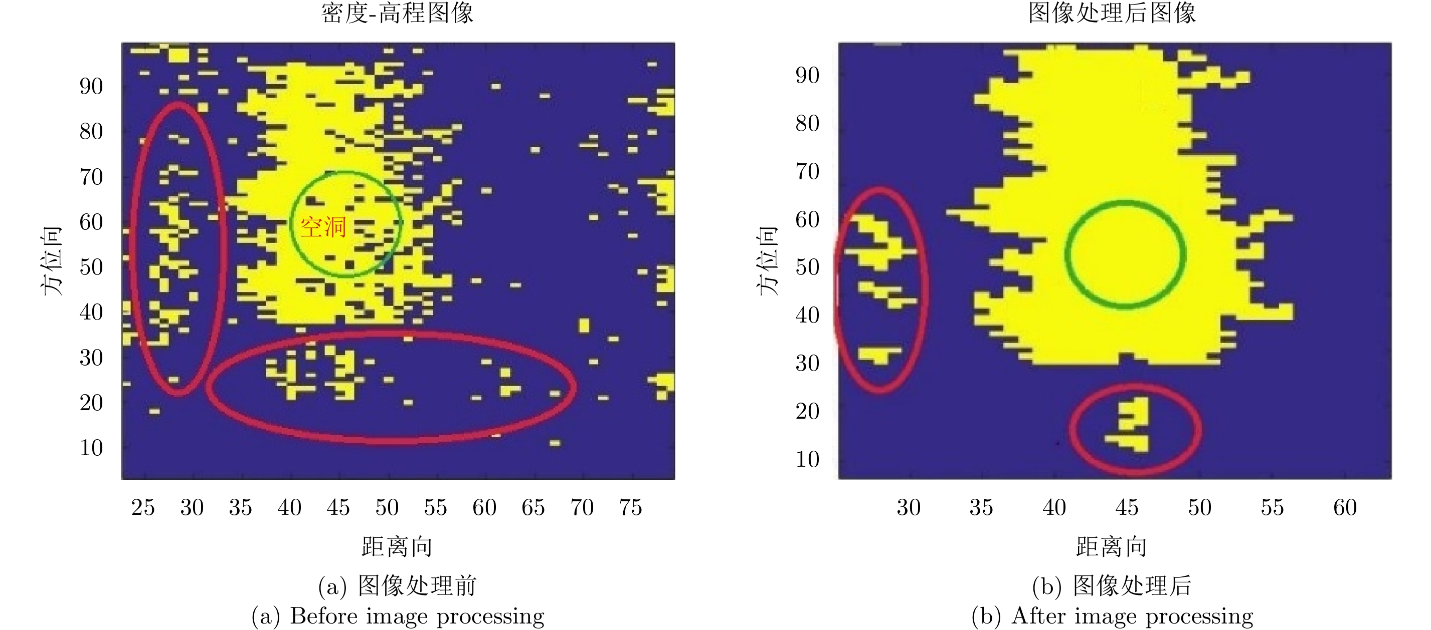
- Figure 7. Density-elevation image before and after image processing
- Figure 8. Local enlargement before and after image processing
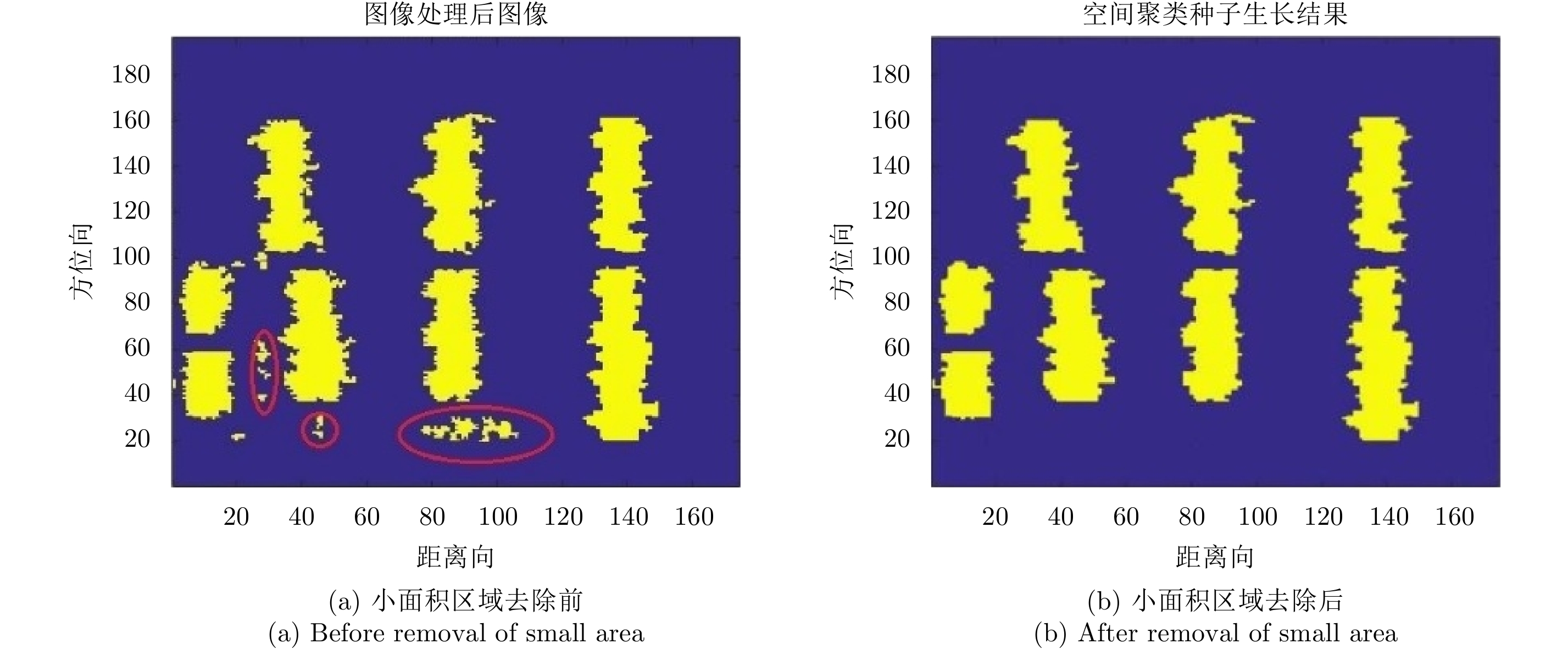
- Figure 9. Density-elevation images before and after removal of small area
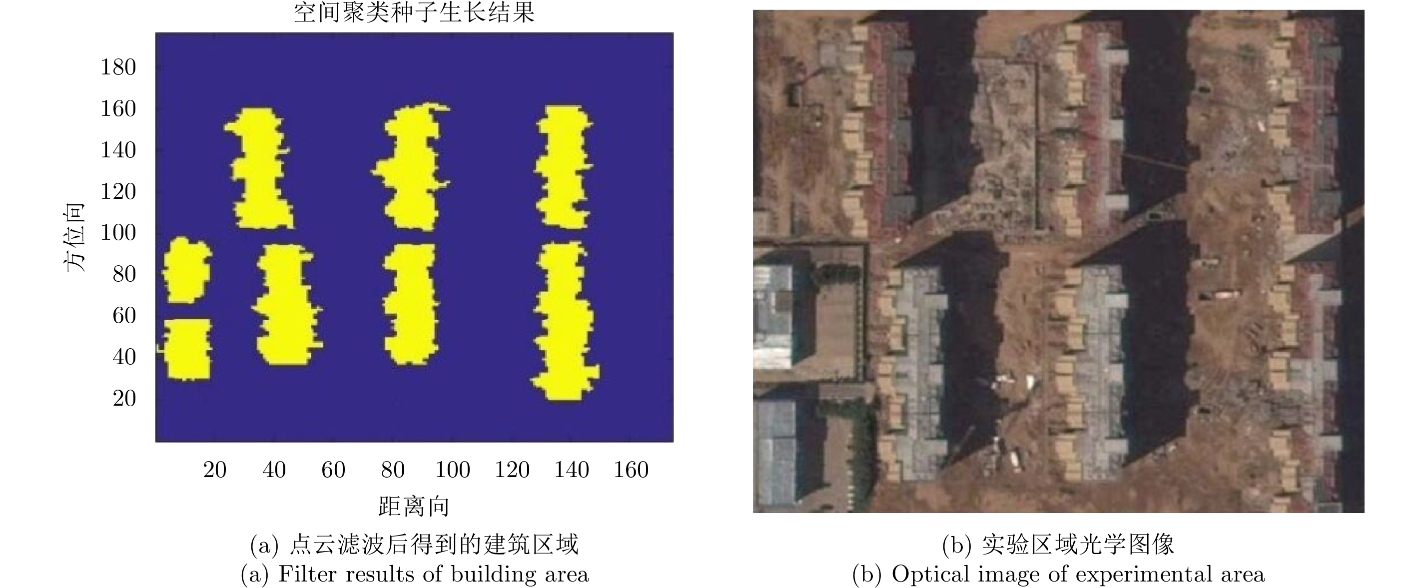
- Figure 10. Comparison of filter results with optical image
- Figure 11.