
 Submit Manuscript
 Peer Review
 Editor Work
- Home
- Articles & Issues
-
Data
- Dataset of Radar Detecting Sea
- SAR Dataset
- SARGroundObjectsTypes
- SARMV3D
- AIRSAT Constellation SAR Land Cover Classification Dataset
- 3DRIED
- UWB-HA4D
- LLS-LFMCWR
- FAIR-CSAR
- MSAR
- SDD-SAR
- FUSAR
- SpaceborneSAR3Dimaging
- Sea-land Segmentation
- SAR Multi-domain Ship Detection Dataset
- SAR-Airport
- Hilly and mountainous farmland time-series SAR and ground quadrat dataset
- SAR images for interference detection and suppression
- HP-SAR Evaluation & Analytical Dataset
- GDHuiYan-ATRNet
- Multi-System Maritime Low Observable Target Dataset
- DatasetinthePaper
- DatasetintheCompetition
- Report
- Course
- About
- Publish
- Editorial Board
- Chinese
| Citation: | Xu Feng, Wang Haipeng, Jin Yaqiu. Deep Learning as Applied in SAR Target Recognition and Terrain Classification[J]. Journal of Radars, 2017, 6(2): 136-148. doi: 10.12000/JR16130

|
Deep Learning as Applied in SAR Target Recognition and Terrain Classification
DOI: 10.12000/JR16130 CSTR: 32380.14.JR16130
-
Abstract
Deep learning such as deep neural networks has revolutionized the computer vision area. Deep learning-based algorithms have surpassed conventional algorithms in terms of performance by a significant margin. This paper reviews our works in the application of deep convolutional neural networks to target recognition and terrain classification using the SAR image. A convolutional neural network is employed to automatically extract a hierarchic feature representation from the data, based on which the target recognition and terrain classification can be conducted. Experimental results on the MSTAR benchmark dataset reveal that deep convolutional network could achieve a state-of-the-art classification accuracy of 99% for the 10-class task. For a polarimetric SAR image classification, we propose complex-valued convolutional neural networks for complex SAR images. This algorithm achieved a state-of-the-art accuracy of 95% for the 15-class task on the Flevoland benchmark dataset.
-

-
References
[1] 张红, 王超, 张波, 等. 高分辨率SAR图像目标识别[M]. 北京: 科学出版社, 2009: 4–7.Zhang Hong, Wang Chao, Zhang Bo, et al. High-Resolution SAR Image Target Recognition[M]. Beijing: Science Press, 2009: 4–7.[2] Moreira A, Prats-Iraola P, Younis M, et al. A tutorial on synthetic aperture radar[J].IEEE GeoscienceandRemote Sensing Magazine, 2013, 1(1): 6–43.[3] 程肖. 基于散射中心模型的SAR图像自动目标识别[D]. [硕士论文], 国防科学技术大学, 2009.Cheng Xiao. SAR ATR algorithm based on the scattering center model[D]. [Master dissertation], National University of Defense Technology, 2009.[4] Krizhevsky A, Sutskever I, and Hinton G E. ImageNet classification with deep convolutional neural networks[J].Advances in Neural Information Processing Systems, 2012, 25(2): 1097–1105. http://web.cs.ucdavis.edu/~yjlee/teaching/ecs289g-fall2016/yuanzhe.pdf[5] He K, Zhang X, Ren S, et al. Delving deep into rectifiers: Surpassing human-level performance on ImageNet classification[C]. IEEE International Conference on Computer Vision, Santiago, Chile, 2015: 1026–1034.[6] Szegedy C, Liu W, Jia Y, et al. Going deeper with convolutions[C]. IEEE Conference on Computer Vision and Pattern Recognition, Boston, M. A., USA, 2015: 1–9.[7] Large Scale Visual Recognition Challenge 2016 (ILSVRC2016). http://image-net.org/challenges/ LSVRC/2016/results.[8] Glorot X, Bordes A, and Bengio Y. Deep sparse rectifier networks[C]. International Conference on Artificial Intelligence and Statistics, Fort Lauderdale, United States, 2011: 315–323.[9] Chen S, Wang H, Xu F, et al. Target classification using the deep convolutional networks for SAR images[J].IEEE Transactions on GeoscienceandRemote Sensing, 2016, 54(8): 4806–4817. http://adsabs.harvard.edu/abs/2016ITGRS.54.4806C[10] Zhang Z, Wang H, Xu F, et al. Complex-valued convolutional neural network and its application in polarimetric SAR image classification[J].IEEE Transactions on Geoscience &Remote Sensing, in press.[11] Hänsch R and Hellwich O. Complex-valued convolutional neural networks for object detection in PolSAR data[C]. European Conference on Synthetic Aperture Radar, Aachen, Germany, 2010: 1–4.[12] Lecun Y, Bengio Y, and Hinton G. Deep learning[J].Nature, 2015, 521(7553): 436–444. doi: 10.1038/nature14539[13] Zeiler M D and Fergus R. Visualization and understanding convolutional networks[C]. European Conference on Computer Vision, Zurich, Switzerland, 2014: 818–833.[14] Srivastava N, Hinton G, Krizhevsky A, et al. Dropout: A simple way to prevent neural networks from overfitting[J].Journal of Machine Learning Research, 2014, 15(1): 1929–1958. https://www.researchgate.net/publication/286794765_Dropout_A_Simple_Way_to_Prevent_Neural_Networks_from_Overfitting[15] Keydel E R. MSTAR extended operating conditions: A tutorial[C]. Algorithms for Synthetic Aperture Radar Imagery Ⅲ, Orlando, F. L., USA, 1996: 228–242.[16] Kong J A, Swartz A A, Yueh H A, et al. Identification of terrain cover using the optimumterrain classifier[J].Journal of Electromagnetic Waves &Applications, 2012, 2(2): 171–194.[17] Lee J S and Grunes M R. Classification of multi-look polarimetric SAR data based on the complex Wishart distribution[J].International Journal of Remote Sensing, 1994, 15(11): 2299–2311. doi: 10.1080/01431169408954244[18] Freeman A, Villasenor J, Klein J D, et al. On the use of multi-frequency and polarimetric radar backscatter features for classification of agricultural crops[J].International Journal of Remote Sensing, 1994, 15(9): 1799–1812. doi: 10.1080/01431169408954210[19] Kouskoulas Y, Ulaby F T, and Pierce L E. The Bayesian Hierarchical Classifier (BHC) and its application to short vegetation using multi-frequency polarimetric SAR[J].IEEE Transactions on GeoscienceandRemote Sensing, 2004, 42(2): 469–477.[20] Lee J S, Grunes M R, Ainsworth T L, et al. Unsupervised classification using polarimetric decomposition and the complex Wishart classifier[J].IEEE Transactions on GeoscienceandRemote Sensing, 1999, 37(5): 2249–2258.[21] Cloude S R and Pottier E. An entropy based classification scheme for land applications of polarimetric SAR[J].IEEE Transactions on GeoscienceandRemote Sensing, 1997, 35(1): 68–78. http://www.academia.edu/10870525/An_entropy_based_classification_scheme_for_land_applications_of_polarimetric_SAR[22] Zhou Y, Wang H, Xu F, et al. Polarimetric SAR image classification using deep convolutional neural networks[J].IEEE Geoscience and Remote Sensing Letters, 2016, 13(12): 1935–1939. doi: 10.1109/LGRS.2016.2618840[23] Spaceborne and Airborne POLSAR Images[OL]. Available: http://envisat.esa.int/POLSARpro/datasets.html29.[24] Yu P, Qin A K, and Clausi D A. Unsupervised polarimetric SAR image segmentation using region growing with edge penalty[J].IEEE Transactions on GeoscienceandRemote Sensing, 2012, 50(4): 1302–1317. -
Proportional views

- Publishing Ethics
- Journal Insights
- Abstracting & Indexing
- Peer Review Policies
- Guide for Authors
- Conference
- ISSN 2095-283X (Print)ISSN 2097-339X (Online)
- CN 10-1030/TN
- CODEN LXEUAO
About Journal
- Sponsor: China Radio Detection and Ranging Industry Association (CRIA)
- Phone: 010-58887062
- Email:radars@aircas.ac.cn
- Publisher: Leida Xuebao Bianjibu (Editorial office of the Journal of Radars)
Contacts Us

京ICP备20021838号-14
Supported by: Beijing Renhe Information Technology Co. Ltd

Export File
Citation
Format
Content
 DownLoad:


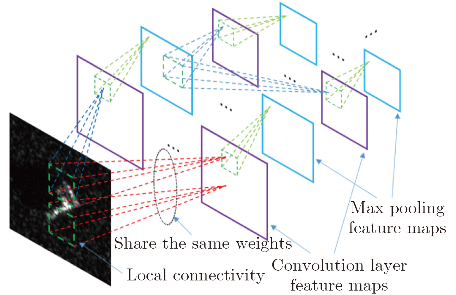
- Figure 1. Deep convolutional neural networks[9]
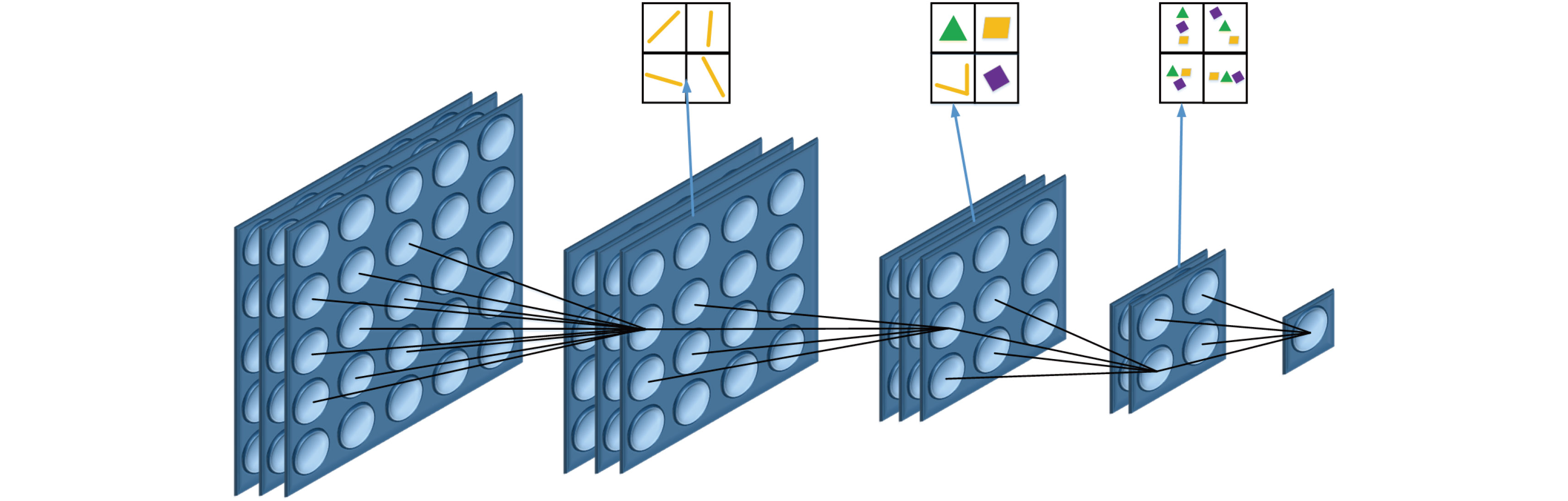
- Figure 2. Hierarchical compositional feature representation capability
- Figure 3. Two types of activation function and their gradients
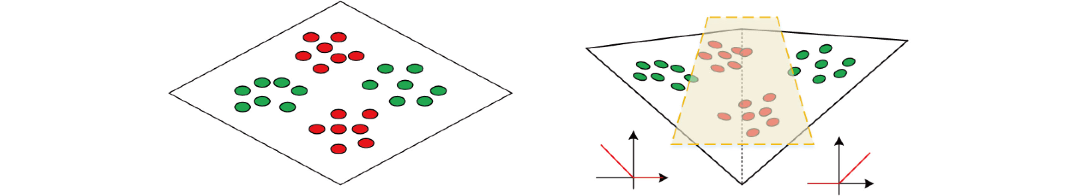
- Figure 4. XOR problem solved by using the nonlinearity of ReLU
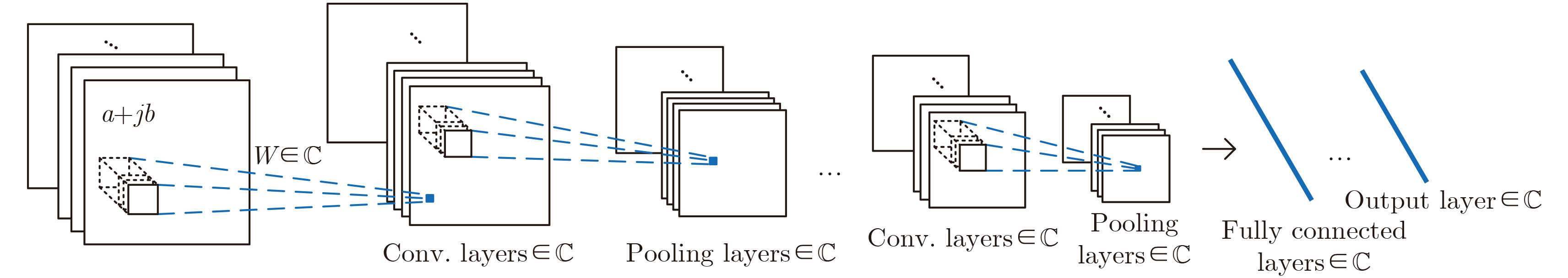
- Figure 5. Structure of complex-valued convolutional neural network[10]
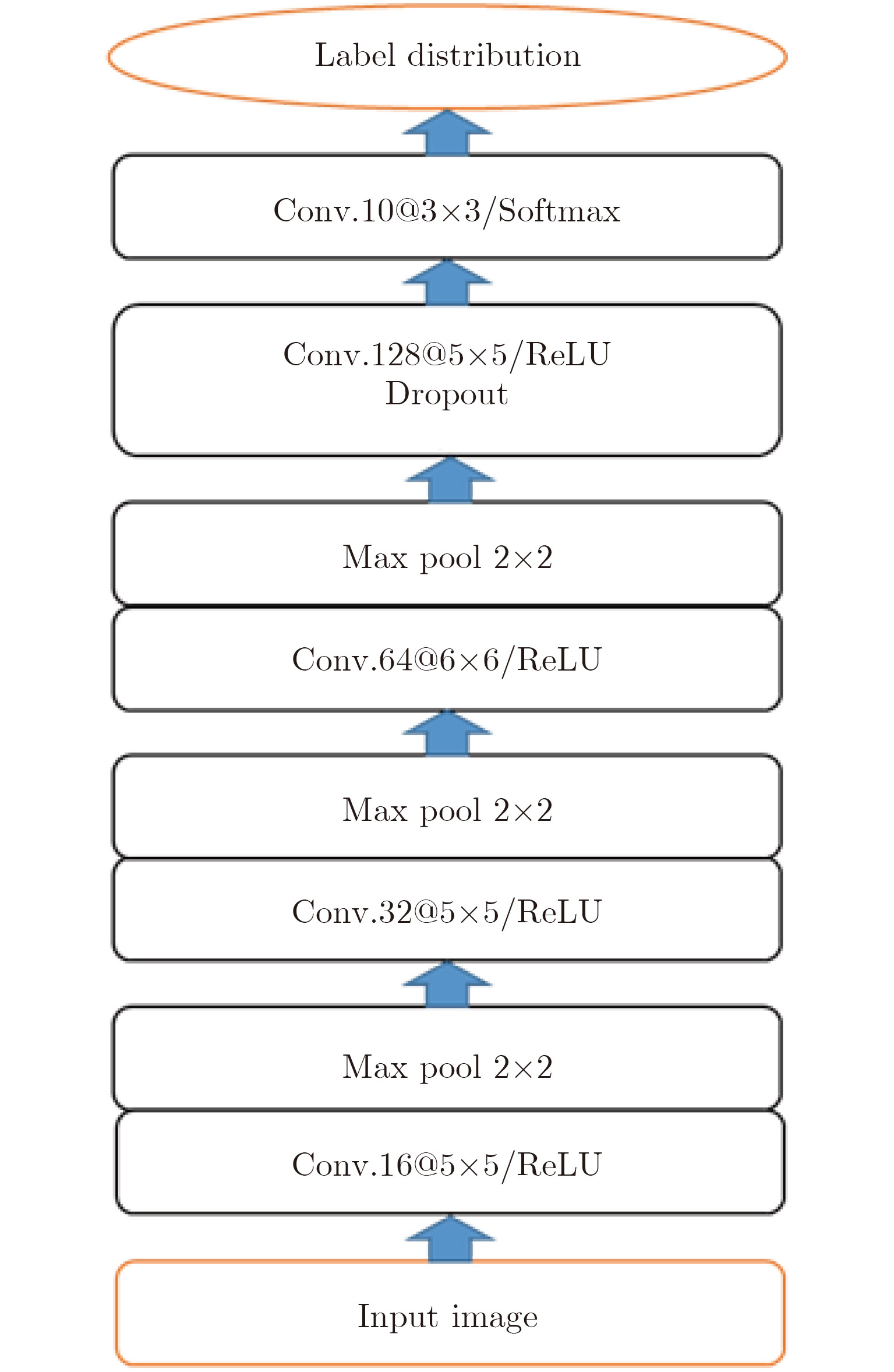
- Figure 6. Network architecture, including 5 trainable layers. Convolution layer is denoted as “conv.(kernel depth)@(kernel size)”
- Figure 7. Ten-class military targets: optical image vs. SAR image
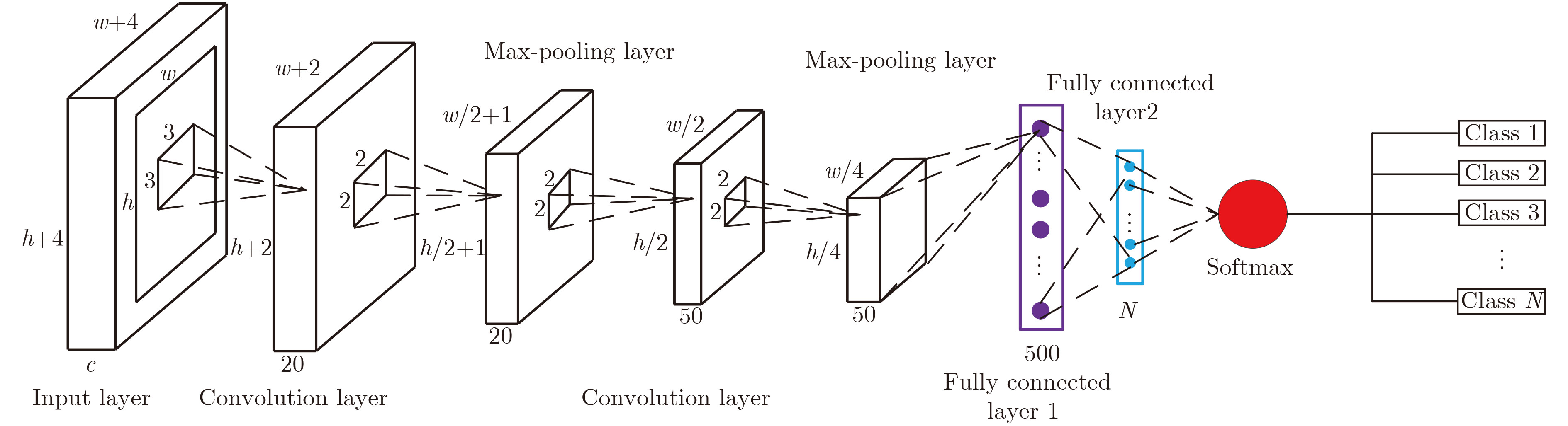
- Figure 8. Real-valued convolutional neural network architecture
- Figure 9. Fully-polarimetric L-band AirSAR image of San Francisco area
- Figure 10. Architecture of CV-CNN
- Figure 11. Flevoland data
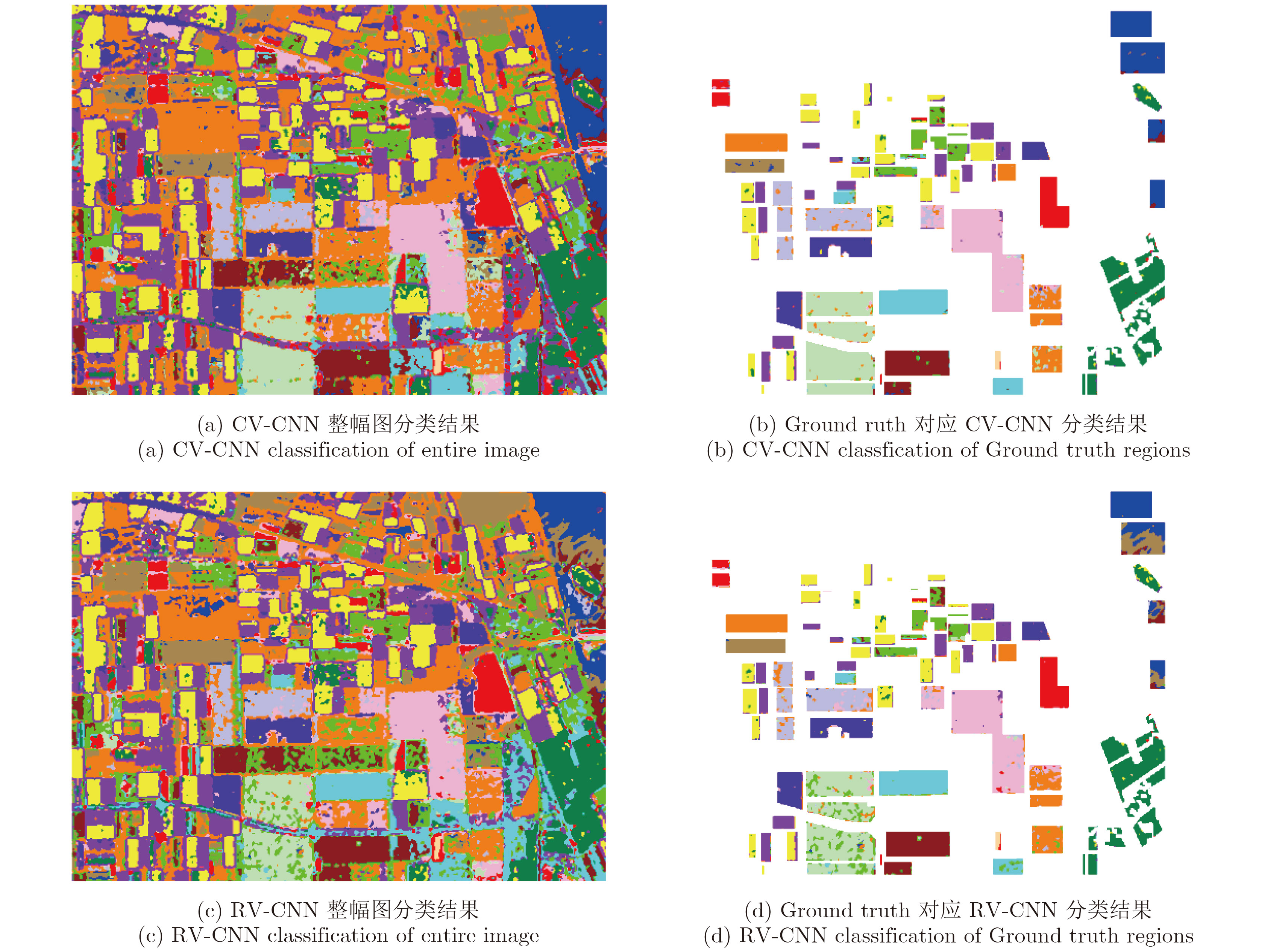
- Figure 12. Classification result
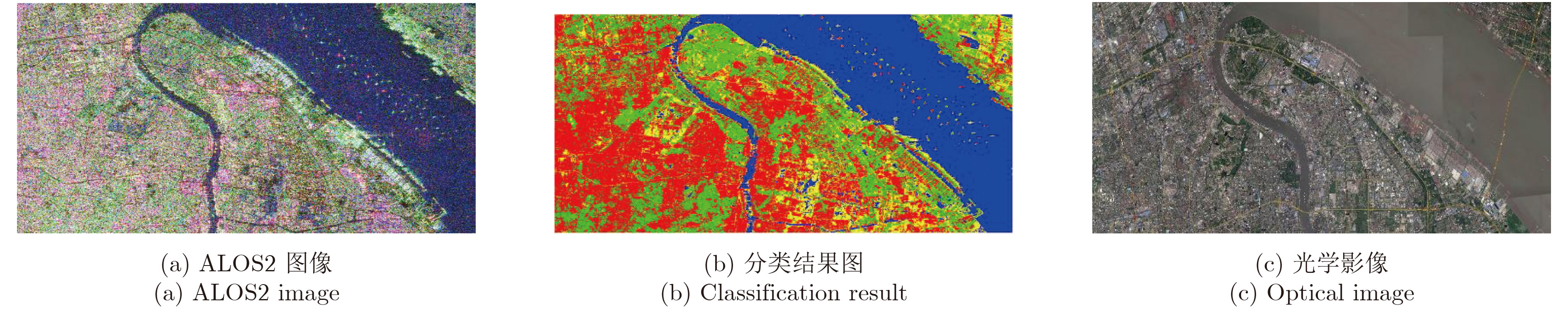
- Figure 13. ALOS2 image of Nanjing used as training data
- Figure 14. Results of another region in Nanjing used for testing
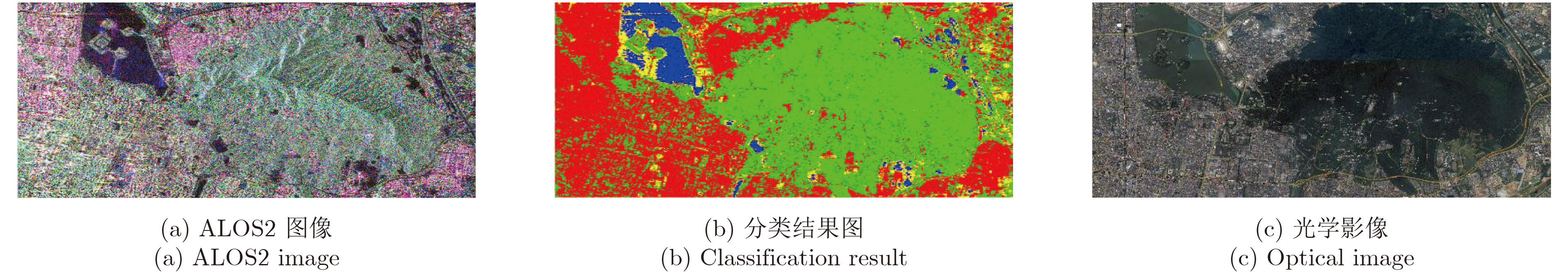
- Figure 15. Results of Shanghai area used for testing
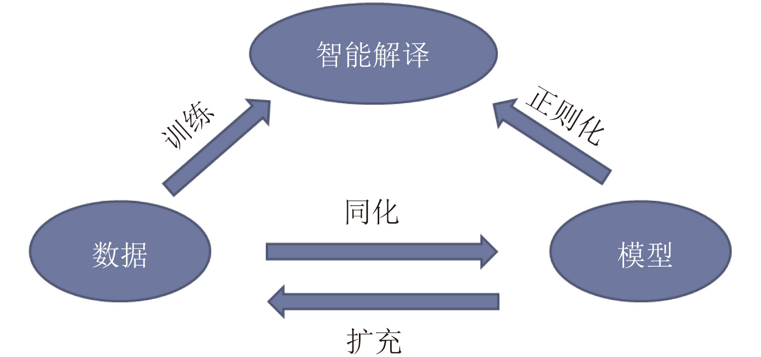
- Figure 16. Data driven-model regularized intelligent SAR imagery interpretation