
 Submit Manuscript
 Peer Review
 Editor Work
| Citation: | LI Xiaowan, LIANG Xingdong, ZHANG Fubo, et al. A geometry constrained moving least squares-based high-precision 3D reconstruction method of mountains from TomoSAR point clouds[J]. Journal of Radars, 2022, 11(3): 363–375. doi: 10.12000/JR22049

|
A Geometry Constrained Moving Least Squares-based High-precision 3D Reconstruction Method of Mountains from TomoSAR Point Clouds
doi: 10.12000/JR22049
More Information-
Abstract
Tomographic Synthetic Aperture Radar (TomoSAR) is an advanced technology for three-dimensional (3D) mountain reconstruction. However, the TomoSAR mountain point clouds have a significant location error in the elevation direction, making high-precision 3D reconstruction of mountains difficult. A geometry constrained Moving Least Squares (MLS)-based high-precision 3D reconstruction method is addressed in this issue. This method not only has the benefits of the traditional MLS in that it uses the local subspace principle for fitting complex surface structures but also fully uses the TomoSAR point cloud characteristic of monotonically increasing elevation with ground distance for reconstruction error correction. The point clouds are first projected onto a new azimuth-ground-elevation domain. Subsequently, the suggested iterative solution-based geometry constrained MLS performs location error correction in the elevation direction. Finally, the projection transformation is used to generate 3D reconstruction results of mountains. The simulation and measurement of airborne array TomoSAR mountain data, AW3D30 DSM data, and 1:10,000 DEM data validate the effectiveness of the proposed method and demonstrate the feasibility and superiority of airborne array TomoSAR for applications such as high-precision 3D mountain reconstruction. -

-
References
[1] KÖNINGER A and BARTEL S. 3D-GIS for urban purposes[J]. Geoinformatica, 1998, 2(1): 79–103. doi: 10.1023/A:1009797106866[2] WANG Yuanyuan and ZHU Xiaoxiang. Automatic feature-based geometric fusion of Multiview TomoSAR point clouds in urban area[J]. IEEE Journal of Selected Topics in Applied Earth Observations and Remote Sensing, 2015, 8(3): 953–965. doi: 10.1109/JSTARS.2014.2361430[3] MINH D H T, LE TOAN T, ROCCA F, et al. SAR tomography for the retrieval of forest biomass and height: Cross-validation at two tropical forest sites in French Guiana[J]. Remote Sensing of Environment, 2016, 175: 138–147. doi: 10.1016/j.rse.2015.12.037[4] EL IDRISSI ESSEBTEY S, VILLARD L, BORDERIES P, et al. Long-term trends of P-band temporal decorrelation over a tropical dense forest-experimental results for the BIOMASS mission[J]. IEEE Transactions on Geoscience and Remote Sensing, 2022, 60: 5102415. doi: 10.1109/TGRS.2021.3082395[5] LI Mofan, XIANG Yin, CHEN Xinliang, et al. Altitude ambiguity suppression method based on dual-frequency interfering and multi-frequency averaging for sparse baseline TomoSAR[J]. Electronics Letters, 2019, 55(22): 1194–1196. doi: 10.1049/el.2019.2198[6] GUO Jiao, LI Zhenfang, and BAO Zheng. Using multibaseline InSAR to recover layovered terrain considering wideband array problem[J]. IEEE Geoscience and Remote Sensing Letters, 2008, 5(4): 583–587. doi: 10.1109/LGRS.2008.2000623[7] ZHU Xiaoxiang and SHAHZAD M. Facade reconstruction using Multiview spaceborne TomoSAR point clouds[J]. IEEE Transactions on Geoscience and Remote Sensing, 2014, 52(6): 3541–3552. doi: 10.1109/TGRS.2013.2273619[8] ZHANG Fubo, LIANG Xingdong, WU Yirong, et al. 3D surface reconstruction of layover areas in continuous terrain for multi-baseline SAR interferometry using a curve model[J]. International Journal of Remote Sensing, 2015, 36(8): 2093–2112. doi: 10.1080/01431161.2015.1030042[9] 张福博. 阵列干涉SAR三维重建信号处理技术研究[D]. [博士论文], 中国科学院大学, 2015.ZHANG Fubo. Research on signal processing of 3-D reconstruction in linear array synthetic aperture radar interferometry[D]. [Ph. D. dissertation], University of Chinese Academy of Sciences, 2015.[10] LI Xiaowan, ZHANG Fubo, LI Yanlei, et al. An elevation ambiguity resolution method based on segmentation and reorganization of TomoSAR point cloud in 3D mountain reconstruction[J]. Remote Sensing, 2021, 13(24): 5118. doi: 10.3390/rs13245118[11] FISCHLER M A and BOLLES R C. Random sample consensus: A paradigm for model fitting with applications to image analysis and automated cartography[J]. Communications of the ACM, 1981, 24(6): 381–395. doi: 10.1145/358669.358692[12] D’HONDT O, GUILLASO S, and HELLWICH O. Geometric primitive extraction for 3D reconstruction of urban areas from tomographic SAR data[C]. Joint Urban Remote Sensing Event 2013, Sao Paulo, Brazil, 2013: 206–209.[13] SHAHZAD M and ZHU Xiaoxiang. Robust reconstruction of building facades for large areas using spaceborne TomoSAR point clouds[J]. IEEE Transactions on Geoscience and Remote Sensing, 2015, 53(2): 752–769. doi: 10.1109/TGRS.2014.2327391[14] SHAHZAD M and ZHU Xiaoxiang. Reconstructing 2-D/3-D building shapes from Spaceborne tomographic synthetic aperture radar data[J]. The International Archives of the Photogrammetry, Remote Sensing and Spatial Information Sciences, 2014, XL-3: 313–320. doi: 10.5194/isprsarchives-XL-3-313-2014[15] ZHOU Siyan, LI Yanlei, ZHANG Fubo, et al. Automatic regularization of TomoSAR point clouds for buildings using neural networks[J]. Sensors, 2019, 19(17): 3748. doi: 10.3390/s19173748[16] AVRON H, SHARF A, GREIF C, et al. ℓ1-sparse reconstruction of sharp point set surfaces[J]. ACM Transactions on Graphics, 2010, 29(5): 135. doi: 10.1145/1857907.1857911[17] FU Yan and ZHAI Jinlei. Research on scattered points cloud denoising algorithm[C]. 2015 IEEE International Conference on Signal Processing, Communications and Computing (ICSPCC), Ningbo, China, 2015: 1–5.[18] GU Xiaoying, LIU Yongshan, and WU Qiong. A filtering algorithm for scattered point cloud based on curvature features classification[J]. Journal of Information and Computational Science, 2015, 12(2): 525–532. doi: 10.12733/jics20105244[19] DIGNE J and DE FRANCHIS C. The bilateral filter for point clouds[J]. Image Processing on Line, 2017, 7: 278–287. doi: 10.5201/ipol.2017.179[20] ZENG Jin, CHEUNG G, NG M, et al. 3D point cloud denoising using graph Laplacian regularization of a low dimensional manifold model[J]. IEEE Transactions on Image Processing, 2020, 29: 3474–3489. doi: 10.1109/TIP.2019.2961429[21] GERNHARDT S, ADAM N, EINEDER M, et al. Potential of very high resolution SAR for persistent scatterer interferometry in urban areas[J]. Annals of GIS, 2010, 16(2): 103–111. doi: 10.1080/19475683.2010.492126[22] NEALEN A. An as-short-as-possible introduction to the least squares, weighted least squares and moving least squares methods for scattered data approximation and interpolation[R/OL]. http://www.nealen.com/projects, 2004.[23] LEVIN D. The approximation power of moving least-squares[J]. Mathematics of Computation, 1998, 67(224): 1517–1531. doi: 10.1090/S0025-5718-98-00974-0[24] JIAO Zekun, DING Chibiao, QIU Xiaolan, et al. Urban 3D imaging using airborne TomoSAR: Contextual information-based approach in the statistical way[J]. ISPRS Journal of Photogrammetry and Remote Sensing, 2020, 170: 127–141. doi: 10.1016/j.isprsjprs.2020.10.013[25] BUDILLON A, EVANGELISTA A, and SCHIRINZI G. Three-dimensional SAR focusing from multipass signals using compressive sampling[J]. IEEE Transactions on Geoscience and Remote Sensing, 2011, 49(1): 488–499. doi: 10.1109/TGRS.2010.2054099[26] 孙婷. 基于移动最小二乘近似权函数的选取及其应用[D]. [硕士论文], 苏州大学, 2010.SUN Ting. Selection and application of weight function based on MLS[D]. [Master dissertation], Soochow University, 2010.[27] 曾清红, 卢德唐. 基于移动最小二乘法的曲线曲面拟合[J]. 工程图学学报, 2004, 25(1): 84–89. doi: 10.3969/j.issn.1003-0158.2004.01.017ZENG Qinghong and LU Detang. Curve and surface fitting based on moving least-squares methods[J]. Journal of Engineering Graphics, 2004, 25(1): 84–89. doi: 10.3969/j.issn.1003-0158.2004.01.017[28] AUER S. 3D synthetic aperture radar simulation for interpreting complex urban reflection scenarios[D]. [Ph. D. dissertation], Technische Universität München, 2011.[29] 生强强. InSAR DEM精度分析与定量评估方法[D]. [硕士论文], 西安电子科技大学, 2018.SHENG Qiangqiang. InSAR DEM accuracy analysis and quantitative evaluation[D]. [Master dissertation], Xidian University, 2018.[30] TAKAKU J, TADONO T, DOUTSU M, et al. Updates of ‘AW3D30’ Alos global digital surface model with other open access datasets[J]. The International Archives of the Photogrammetry, Remote Sensing and Spatial Information Sciences, 2020, XLIII-B4-2020: 183–189. doi: 10.5194/isprs-archives-XLIII-B4-2020-183-2020 -
Proportional views


- Publishing Ethics
- Journal Insights
- Abstracting & Indexing
- Peer Review Policies
- Guide for Authors
- ISSN 2095-283X (Print)ISSN 2097-339X (Online)
- CN 10-1030/TN
- CODEN LXEUAO
About Journal
- Sponsor: China Radio Detection and Ranging Industry Association (CRIA)
- Phone: 010-58887062
- Email:radars@aircas.ac.cn
- Publisher: Leida Xuebao Bianjibu (Editorial office of the Journal of Radars)
Contacts Us

京ICP备20021838号-8
Supported by: Beijing Renhe Information Technology Co. Ltd

Export File
Citation
Format
Content
 DownLoad:


- Figure 1. Diagram of TomoSAR mountain observation geometry (y and z indicate the ground direction and the height direction, respectively, r and s indicate the range direction and the elevation direction, respectively)
- Figure 2. Flowchart of the geometry constrained MLS method
- Figure 3. The S shaped layover mountainous terrain on the range-elevation plane
- Figure 4. Diagram of two typical terrain for stagnation point positioning
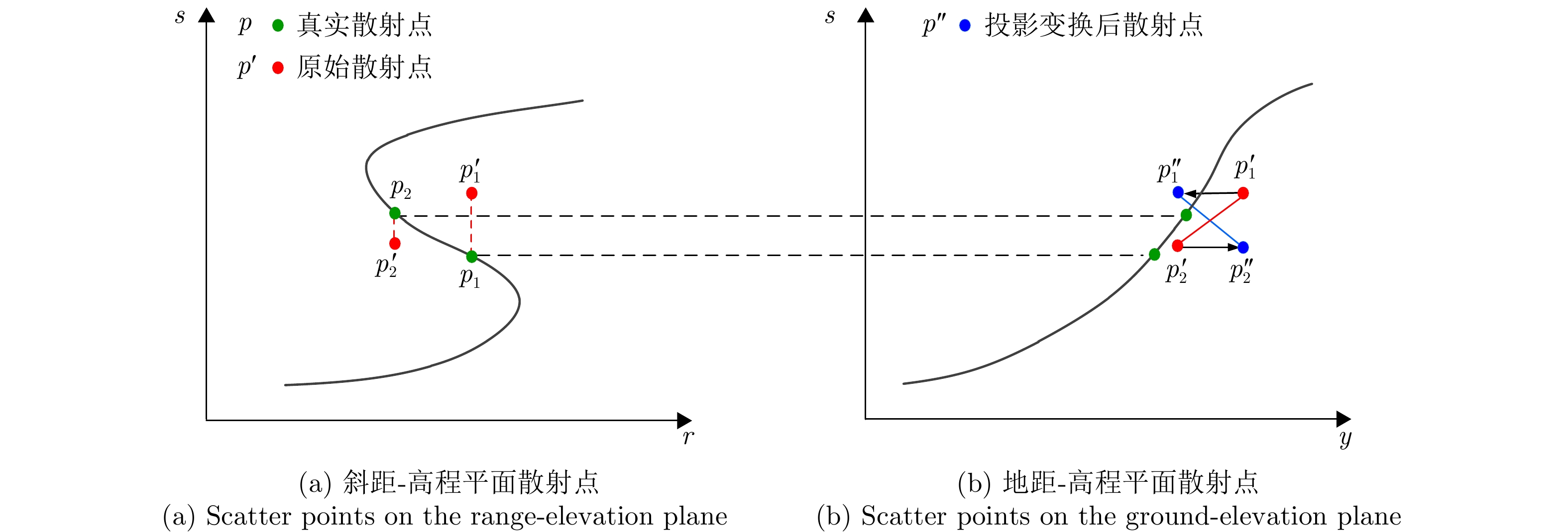
- Figure 5. Diagram of projection transform
- Figure 6. Simulation results of LS, MLS and the proposed method
- Figure 7. The precision comparison curves of different methods based on data 1
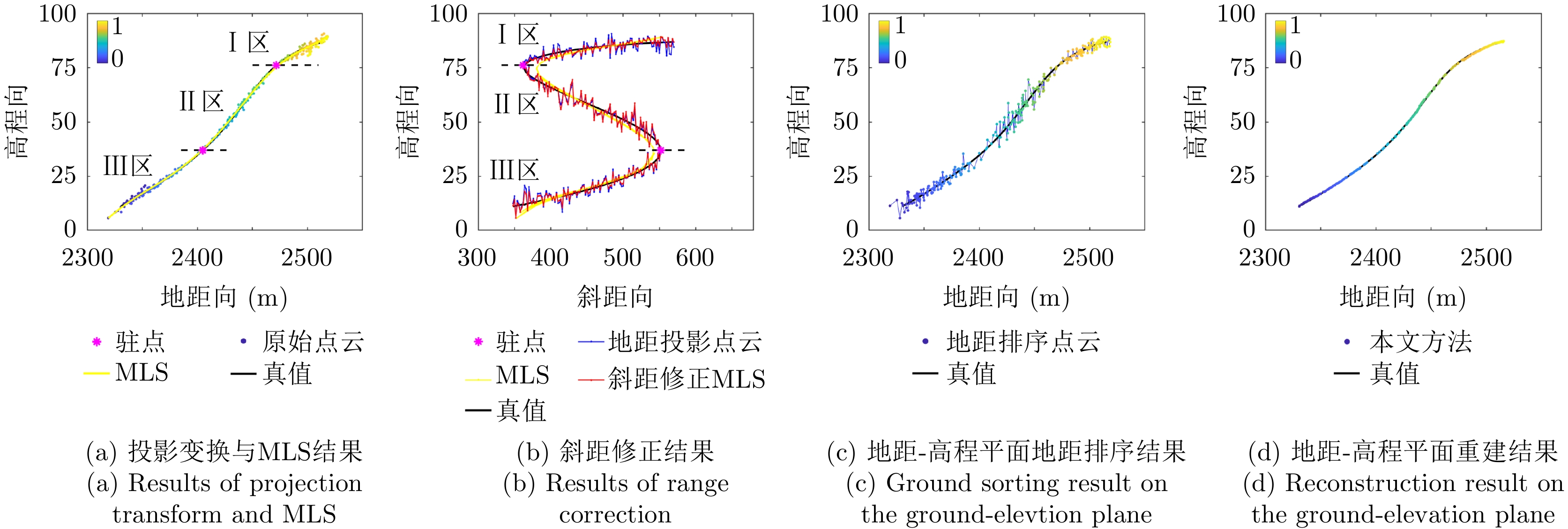
- Figure 8. The main intermediate results of the proposed method for slice 5
- Figure 9. SAR image of the observation scene (the color map indicates the normalized scattering intensity)
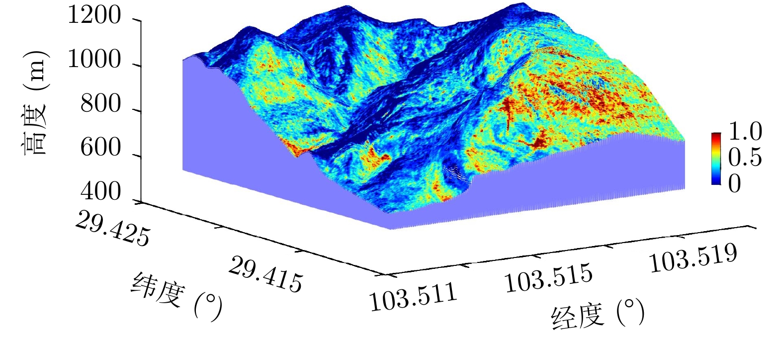
- Figure 10. Results of the real experiment
- Figure 11. Optical image of the observation scene
- Figure 12. The three-dimensional reconstruction image (the color map indicates the normalized scattering intensity)